Bridge Statistics for Roscoe, Illinois (IL)
Condition, Traffic, Stress, Structural Evaluation, Project Costs
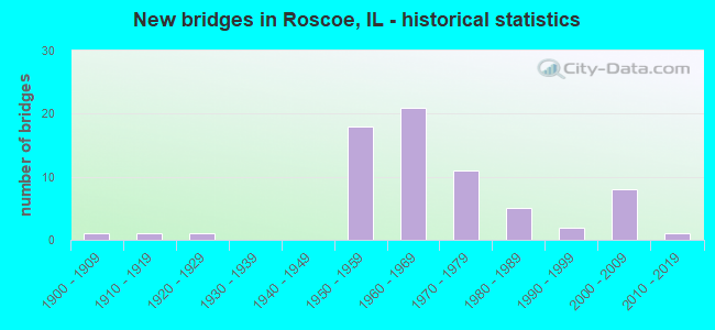
- New bridges - historical statistics
- 11900-1909
- 11910-1919
- 11920-1929
- 181950-1959
- 211960-1969
- 111970-1979
- 51980-1989
- 21990-1999
- 82000-2009
- 12010-2019
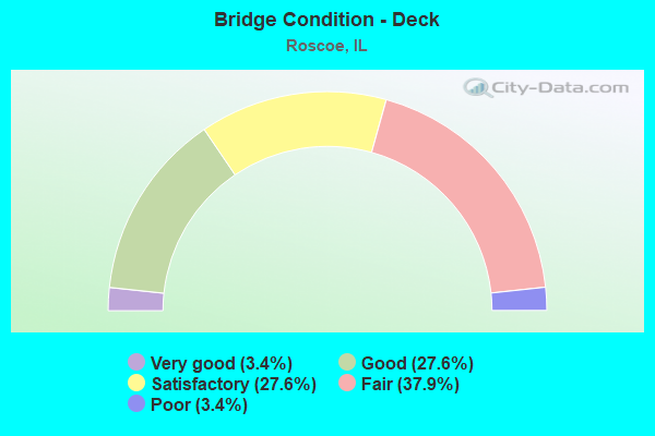
- Bridge Condition - Deck
- 3.4%Very good
- 27.6%Good
- 27.6%Satisfactory
- 37.9%Fair
- 3.4%Poor
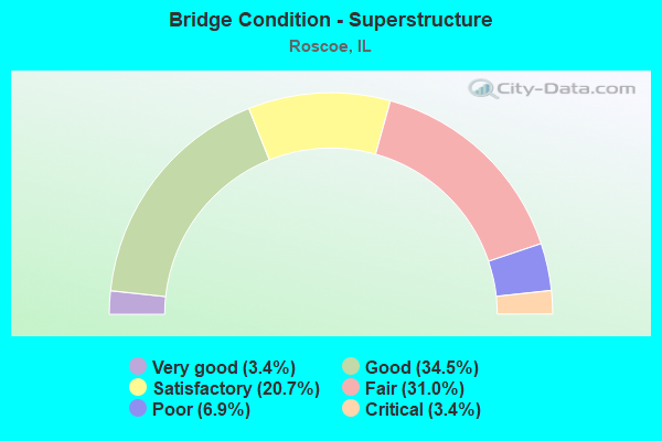
- Bridge Condition - Superstructure
- 3.4%Very good
- 34.5%Good
- 20.7%Satisfactory
- 31.0%Fair
- 6.9%Poor
- 3.4%Critical
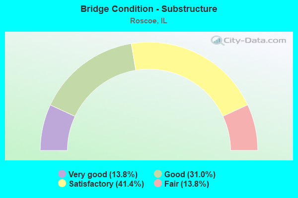
- Bridge Condition - Substructure
- 13.8%Very good
- 31.0%Good
- 41.4%Satisfactory
- 13.8%Fair
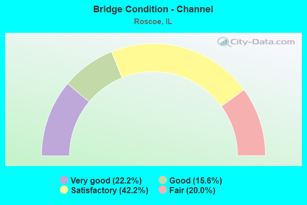
- Bridge Condition - Channel
- 22.2%Very good
- 15.6%Good
- 42.2%Satisfactory
- 20.0%Fair
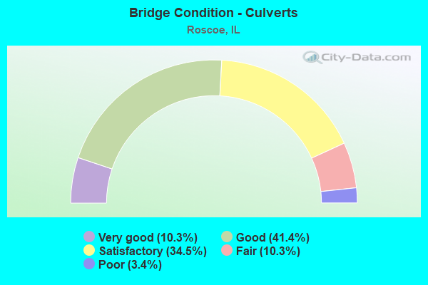
- Bridge Condition - Culverts
- 10.3%Very good
- 41.4%Good
- 34.5%Satisfactory
- 10.3%Fair
- 3.4%Poor
Find on map >> Show street view
Structure Number: 1016602, Location: .2 MI S OF SWANSON R (Lat: 42.389114, Lng: -89.013267), Route carried "on" structure: City street , Year Built: 2007, Status: Open, Structure Length: 1.75m (5.74ft), Average Daily Traffic: 1,000 (year 2017), Average Future Daily Traffic: 350 (year 2032), Design Load: HS 25 or greater, Features Intersected: S BR MCDONALD CRK, Facility Carried by Structure: SWANSON DR
Minimum Vertical Clearance: 30+ m (98+ ft), Kilometerpoint: 0.290, Lanes on structure: 2, Owner: City or Municipal Highway Agency, Approaching Roadway Width: 11.6m (38.1ft), Material/Design: Concrete, Design/Construction: Culvert, Number Of Spans In Main Unit: 5, Length of Maximum Span: 3.0m (9.8ft)
Condition: Channel: Fair, Culverts: Satisfactory, Operating Rating: 53.8 metric tons, Method Used To Determine Operating Rating: Field evaluation and documented engineering judgment, Inventory Rating: 32.4 metric tons, Method Used To Determine Inventory Rating: Field evaluation and documented engineering judgment, Structural Evaluation: Equal to present minimum criteria, Waterway Adequacy: Better than present minimum criteria, Approach Roadway Alignment: Equal to present desirable criteria, Designated Inspection Frequency: Every 24 months, Inspection Date: September 2020
Find on map >> Show street view
Structure Number: 1019901, Location: 1 MI E OF ROSCOE (Lat: 42.418550, Lng: -88.985731), Route carried "on" structure: Interstate 39, Year Built: 1958, Status: Open, Structure Length: 4.05m (13.29ft), Average Daily Traffic: 23,400 (year 2020), Truck Traffic: 34%, Average Future Daily Traffic: 38,800 (year 2040), Design Load: HS 20, Features Intersected: BURR OAK RD, Facility Carried by Structure: I-90 S B
Minimum Vertical Clearance: 30+ m (98+ ft), Kilometerpoint: 216.692, Lanes on structure: 2, Lanes under structure: 2, Base Highway Network: Yes, Toll: On toll road, Owner: State Toll Authority, Approaching Roadway Width: 10.7m (35.1ft), Skew: 1 degrees, Material/Design: Prestressed concrete, Design/Construction: Stringer/Multi-beam, Number Of Spans In Main Unit: 3, Length of Maximum Span: 13.7m (44.9ft), Curb-To-Curb Width: 10.5m (34.4ft), Out-to-Out Width: 11.8m (38.7ft)
Condition: Deck: Good, Superstructure: Good, Substructure: Good, Operating Rating: 97.2 metric tons, Method Used To Determine Operating Rating: Load Factor (LF) rating reported by rating factor (RF) method using MS18 loading, Inventory Rating: 62.2 metric tons, Method Used To Determine Inventory Rating: Load Factor (LF) rating reported by rating factor (RF) method using MS18 loading, Structural Evaluation: Better than present minimum criteria, Deck Geometry: Meets minimum limits, Underclear: Meets minimum limits, Approach Roadway Alignment: Equal to present desirable criteria, Designated Inspection Frequency: Every 24 months, Inspection Date: June 2019, Deck Structure Type: Concrete Precast Panels
Find on map >> Show street view
Structure Number: 1019902, Location: 1 MI E OF ROSCOE (Lat: 42.418408, Lng: -88.985728), Route carried "on" structure: Interstate 39, Year Built: 1958, Status: Open, Structure Length: 4.05m (13.29ft), Average Daily Traffic: 23,400 (year 2020), Truck Traffic: 34%, Average Future Daily Traffic: 37,800 (year 2040), Design Load: HS 20, Features Intersected: BURR OAK RD, Facility Carried by Structure: I-90 N B
Minimum Vertical Clearance: 30+ m (98+ ft), Kilometerpoint: 216.676, Lanes on structure: 2, Lanes under structure: 2, Base Highway Network: Yes, Toll: On toll road, Owner: State Toll Authority, Approaching Roadway Width: 10.7m (35.1ft), Skew: 1 degrees, Material/Design: Prestressed concrete, Design/Construction: Stringer/Multi-beam, Number Of Spans In Main Unit: 3, Length of Maximum Span: 13.7m (44.9ft), Curb-To-Curb Width: 10.5m (34.4ft), Out-to-Out Width: 11.8m (38.7ft)
Condition: Deck: Good, Superstructure: Good, Substructure: Good, Operating Rating: 78.7 metric tons, Method Used To Determine Operating Rating: Load Factor (LF) rating reported by rating factor (RF) method using MS18 loading, Inventory Rating: 47.3 metric tons, Method Used To Determine Inventory Rating: Load Factor (LF) rating reported by rating factor (RF) method using MS18 loading, Structural Evaluation: Better than present minimum criteria, Deck Geometry: Meets minimum limits, Underclear: Meets minimum limits, Approach Roadway Alignment: Equal to present desirable criteria, Designated Inspection Frequency: Every 24 months, Inspection Date: June 2019, Deck Structure Type: Concrete Precast Panels
Find on map >> Show street view
Structure Number: 1019903, Location: 1 MI E OF ROSCOE (Lat: 42.411239, Lng: -88.985611), Route carried "on" structure: Interstate 39, Year Built: 1958, Status: Open, Structure Length: 4.94m (16.21ft), Average Daily Traffic: 23,400 (year 2020), Truck Traffic: 34%, Average Future Daily Traffic: 37,800 (year 2040), Design Load: HS 20, Features Intersected: STONEBRIDGE TRAIL, Facility Carried by Structure: I-90 S B
Minimum Vertical Clearance: 30+ m (98+ ft), Kilometerpoint: 215.855, Lanes on structure: 2, Base Highway Network: Yes, Toll: On toll road, Owner: State Toll Authority, Approaching Roadway Width: 10.7m (35.1ft), Skew: 1 degrees, Material/Design: Prestressed concrete, Design/Construction: Stringer/Multi-beam, Number Of Spans In Main Unit: 3, Length of Maximum Span: 18.6m (61.0ft), Curb-To-Curb Width: 10.5m (34.4ft), Out-to-Out Width: 12.4m (40.7ft)
Condition: Deck: Satisfactory, Superstructure: Good, Substructure: Good, Operating Rating: 63.8 metric tons, Method Used To Determine Operating Rating: Load Factor (LF) rating reported by rating factor (RF) method using MS18 loading, Inventory Rating: 38.2 metric tons, Method Used To Determine Inventory Rating: Load Factor (LF) rating reported by rating factor (RF) method using MS18 loading, Structural Evaluation: Better than present minimum criteria, Deck Geometry: Meets minimum limits, Approach Roadway Alignment: Equal to present desirable criteria, Designated Inspection Frequency: Every 24 months, Inspection Date: June 2019, Deck Structure Type: Concrete Precast Panels
Find on map >> Show street view
Structure Number: 1019904, Location: 1 MI E OF ROSCOE (Lat: 42.411097, Lng: -88.985611), Route carried "on" structure: Interstate 39, Year Built: 1958, Status: Open, Structure Length: 4.94m (16.21ft), Average Daily Traffic: 23,400 (year 2020), Truck Traffic: 34%, Average Future Daily Traffic: 37,800 (year 2040), Design Load: HS 20, Features Intersected: STONEBRIDGE TRAIL, Facility Carried by Structure: I-90 N B
Minimum Vertical Clearance: 30+ m (98+ ft), Kilometerpoint: 215.839, Lanes on structure: 2, Base Highway Network: Yes, Toll: On toll road, Owner: State Toll Authority, Approaching Roadway Width: 10.7m (35.1ft), Skew: 1 degrees, Material/Design: Prestressed concrete, Design/Construction: Stringer/Multi-beam, Number Of Spans In Main Unit: 3, Length of Maximum Span: 18.6m (61.0ft), Curb-To-Curb Width: 10.5m (34.4ft), Out-to-Out Width: 12.4m (40.7ft)
Condition: Deck: Good, Superstructure: Very good, Substructure: Good, Operating Rating: 66.1 metric tons, Method Used To Determine Operating Rating: Load Factor (LF) rating reported by rating factor (RF) method using MS18 loading, Inventory Rating: 39.9 metric tons, Method Used To Determine Inventory Rating: Load Factor (LF) rating reported by rating factor (RF) method using MS18 loading, Structural Evaluation: Better than present minimum criteria, Deck Geometry: Meets minimum limits, Approach Roadway Alignment: Equal to present desirable criteria, Designated Inspection Frequency: Every 24 months, Inspection Date: June 2019, Deck Structure Type: Concrete Precast Panels
Find on map >> Show street view
Structure Number: 1019913, Location: 1 MI E OF ROSCOE (Lat: 42.427931, Lng: -88.986550), Route carried "on" structure: Other road , Year Built: 1958, Status: Open, Structure Length: 6.86m (22.51ft), Average Daily Traffic: 5,000 (year 2017), Truck Traffic: 4%, Average Future Daily Traffic: 5,700 (year 2040), Design Load: HS 15, Features Intersected: I-90, Facility Carried by Structure: ELEVATOR RD
Minimum Vertical Clearance: 30+ m (98+ ft), Kilometerpoint: 8.674, Lanes on structure: 2, Lanes under structure: 4, Base Highway Network: Yes, Owner: State Toll Authority, Approaching Roadway Width: 10.7m (35.1ft), Skew: 1 degrees, Material/Design: Prestressed concrete, Design/Construction: Stringer/Multi-beam, Number Of Spans In Main Unit: 4, Length of Maximum Span: 19.8m (65.0ft), Curb or Sidewalk Widths: Left: 0.6m (2.0ft), Right: 0.6m (2.0ft), Curb-To-Curb Width: 8.5m (27.9ft), Out-to-Out Width: 10.5m (34.4ft)
Condition: Deck: Fair, Superstructure: Poor, Substructure: Fair, Operating Rating: 64.5 metric tons, Method Used To Determine Operating Rating: Load Factor (LF) rating reported by rating factor (RF) method using MS18 loading, Inventory Rating: 38.6 metric tons, Method Used To Determine Inventory Rating: Load Factor (LF) rating reported by rating factor (RF) method using MS18 loading, Structural Evaluation: Meets minimum limits, Deck Geometry: Meets minimum limits, Underclear: Meets minimum limits, Approach Roadway Alignment: Equal to present desirable criteria, Designated Inspection Frequency: Every 24 months, Inspection Date: July 2020, Deck Structure Type: Concrete Precast Panels
Find on map >> Show street view
Structure Number: 1019917, Location: 2.5 MI N ILL 173 (Lat: 42.405919, Lng: -88.984131), Route carried "on" structure: Other road , Year Built: 1958, Status: Open, Structure Length: 11.40m (37.40ft), Average Daily Traffic: 3,700 (year 2017), Truck Traffic: 19%, Average Future Daily Traffic: 5,800 (year 2040), Design Load: HS 15, Features Intersected: I-90, Facility Carried by Structure: BELVIDERE RD
Minimum Vertical Clearance: 30+ m (98+ ft), Kilometerpoint: 7.982, Lanes on structure: 2, Lanes under structure: 4, Base Highway Network: Yes, Owner: State Toll Authority, Approaching Roadway Width: 11.0m (36.1ft), Skew: 3 degrees, Material/Design: Steel, Design/Construction: Stringer/Multi-beam, Number Of Spans In Main Unit: 4, Length of Maximum Span: 33.2m (108.9ft), Curb or Sidewalk Widths: Left: 0.6m (2.0ft), Right: 0.6m (2.0ft), Curb-To-Curb Width: 8.5m (27.9ft), Out-to-Out Width: 10.5m (34.4ft)
Condition: Deck: Satisfactory, Superstructure: Satisfactory, Substructure: Good, Operating Rating: 97.2 metric tons, Method Used To Determine Operating Rating: Load Factor (LF) rating reported by rating factor (RF) method using MS18 loading, Inventory Rating: 69.7 metric tons, Method Used To Determine Inventory Rating: Load Factor (LF) rating reported by rating factor (RF) method using MS18 loading, Structural Evaluation: Equal to present minimum criteria, Deck Geometry: Meets minimum limits, Underclear: Somewhat better than minimum adequacy, Approach Roadway Alignment: Equal to present desirable criteria, Designated Inspection Frequency: Every 24 months, Inspection Date: June 2019, Deck Structure Type: Concrete Cast-file-Place
Find on map >> Show street view
Structure Number: 1019919, Location: 2.5 MI S OF ILL 75 (Lat: 42.456850, Lng: -88.995189), Route carried "on" structure: Other road , Year Built: 1958, Status: Open, Structure Length: 6.55m (21.49ft), Average Daily Traffic: 2,225 (year 2017), Truck Traffic: 6%, Average Future Daily Traffic: 4,900 (year 2040), Features Intersected: I-90, Facility Carried by Structure: ROCKTON RD
Minimum Vertical Clearance: 30+ m (98+ ft), Kilometerpoint: 8.545, Lanes on structure: 2, Lanes under structure: 4, Base Highway Network: Yes, Owner: County Highway Agency, Approaching Roadway Width: 11.6m (38.1ft), Material/Design: Prestressed concrete, Design/Construction: Stringer/Multi-beam, Number Of Spans In Main Unit: 4, Length of Maximum Span: 19.5m (64.0ft), Curb or Sidewalk Widths: Left: 0.6m (2.0ft), Right: 0.6m (2.0ft), Curb-To-Curb Width: 8.5m (27.9ft), Out-to-Out Width: 10.5m (34.4ft)
Condition: Deck: Fair, Superstructure: Fair, Substructure: Satisfactory, Operating Rating: 62.5 metric tons, Method Used To Determine Operating Rating: Load Factor (LF) rating reported by rating factor (RF) method using MS18 loading, Inventory Rating: 37.6 metric tons, Method Used To Determine Inventory Rating: Load Factor (LF) rating reported by rating factor (RF) method using MS18 loading, Structural Evaluation: Somewhat better than minimum adequacy, Deck Geometry: Meets minimum limits, Underclear: Meets minimum limits, Approach Roadway Alignment: Equal to present desirable criteria, Designated Inspection Frequency: Every 24 months, Inspection Date: July 2020, Deck Structure Type: Concrete Precast Panels, Wearing Surface/Protective System: Wearing Surface: Latex Concrete, Deck Protection: Epoxy Coated Reinforcing
Find on map >> Show street view
Structure Number: 1019921, Location: 1.5 MI N ILL 173 (Lat: 42.388897, Lng: -88.974642), Route carried "on" structure: Other road , Year Built: 1958, Status: Open, Structure Length: 7.07m (23.20ft), Average Daily Traffic: 2,250 (year 2017), Truck Traffic: 16%, Average Future Daily Traffic: 4,200 (year 2040), Design Load: HS 15, Features Intersected: I-90, Facility Carried by Structure: SWANSON RD
Minimum Vertical Clearance: 30+ m (98+ ft), Kilometerpoint: 3.524, Lanes on structure: 2, Lanes under structure: 4, Owner: State Toll Authority, Approaching Roadway Width: 8.5m (27.9ft), Skew: 1 degrees, Material/Design: Prestressed concrete, Design/Construction: Stringer/Multi-beam, Number Of Spans In Main Unit: 4, Length of Maximum Span: 20.1m (65.9ft), Curb or Sidewalk Widths: Left: 0.6m (2.0ft), Right: 0.6m (2.0ft), Curb-To-Curb Width: 7.3m (24.0ft), Out-to-Out Width: 9.2m (30.2ft)
Condition: Deck: Satisfactory, Superstructure: Satisfactory, Substructure: Good, Operating Rating: 69.3 metric tons, Method Used To Determine Operating Rating: Load Factor (LF) rating reported by rating factor (RF) method using MS18 loading, Inventory Rating: 41.5 metric tons, Method Used To Determine Inventory Rating: Load Factor (LF) rating reported by rating factor (RF) method using MS18 loading, Structural Evaluation: Equal to present minimum criteria, Deck Geometry: High priority of replacement, Underclear: Meets minimum limits, Approach Roadway Alignment: Equal to present desirable criteria, Designated Inspection Frequency: Every 24 months, Inspection Date: June 2019, Deck Structure Type: Concrete Precast Panels
Find on map >> Show street view
Structure Number: 101993, Location: 1 MI SE OF ROCKTON (Lat: 42.439553, Lng: -89.042594), Route carried "on" structure: County highway , Year Built: 1925, Status: Open, Structure Length: 2.44m (8.01ft), Average Daily Traffic: 650 (year 2017), Average Future Daily Traffic: 600 (year 2040), Design Load: H 15, Features Intersected: DRY RUN CREEK, Facility Carried by Structure: HONONEGAH PRES RD
Minimum Vertical Clearance: 30+ m (98+ ft), Kilometerpoint: 0.338, Lanes on structure: 2, Owner: Local Park, Forest, or Reservation Agency, Approaching Roadway Width: 11.3m (37.1ft), Material/Design: Concrete, Design/Construction: Arch - Thru, Number Of Spans In Main Unit: 1, Length of Maximum Span: 22.9m (75.1ft), Curb-To-Curb Width: 5.8m (19.0ft), Out-to-Out Width: 6.6m (21.7ft)
Condition: Deck: Satisfactory, Superstructure: Satisfactory, Substructure: Satisfactory, Channel: Satisfactory, Operating Rating: 40.5 metric tons, Method Used To Determine Operating Rating: Field evaluation and documented engineering judgment, Inventory Rating: 24.3 metric tons, Method Used To Determine Inventory Rating: Field evaluation and documented engineering judgment, Structural Evaluation: Equal to present minimum criteria, Deck Geometry: High priority of replacement, Waterway Adequacy: Equal to present minimum criteria, Approach Roadway Alignment: Better than present minimum criteria, Designated Inspection Frequency: Every 24 months, Inspection Date: May 2020, Deck Structure Type: Concrete Cast-file-Place
Find on map >> Show street view
Structure Number: 1019951, Location: 1 MI NE OF ROSCOE (Lat: 42.451883, Lng: -88.994972), Route carried "on" structure: Interstate 39, Year Built: 1958, Status: Open, Structure Length: 1.02m (3.35ft), Average Daily Traffic: 23,400 (year 2020), Truck Traffic: 34%, Average Future Daily Traffic: 75,200 (year 2040), Design Load: HS 20, Features Intersected: STREAM, Facility Carried by Structure: I-90
Minimum Vertical Clearance: 30+ m (98+ ft), Kilometerpoint: 220.410, Lanes on structure: 4, Base Highway Network: Yes, Toll: On toll road, Owner: State Toll Authority, Approaching Roadway Width: 36.6m (120.1ft), Skew: 11 degrees, Material/Design: Steel, Design/Construction: Culvert, Number Of Spans In Main Unit: 2, Length of Maximum Span: 4.0m (13.1ft)
Condition: Channel: Very good, Culverts: Satisfactory, Structural Evaluation: Equal to present minimum criteria, Waterway Adequacy: Equal to present desirable criteria, Approach Roadway Alignment: Equal to present desirable criteria, Designated Inspection Frequency: Every 24 months, Inspection Date: June 2019
Find on map >> Show street view
Structure Number: 1019952, Location: 1 MI E OF ROSCOE (Lat: 42.435314, Lng: -88.989217), Route carried "on" structure: Interstate 39, Year Built: 1958, Status: Open, Structure Length: 2.27m (7.45ft), Average Daily Traffic: 23,400 (year 2020), Truck Traffic: 34%, Average Future Daily Traffic: 75,200 (year 2040), Design Load: HS 20, Features Intersected: N KINNIKINNICK CREEK, Facility Carried by Structure: I-90
Minimum Vertical Clearance: 30+ m (98+ ft), Kilometerpoint: 218.559, Lanes on structure: 4, Base Highway Network: Yes, Toll: On toll road, Owner: State Toll Authority, Approaching Roadway Width: 36.6m (120.1ft), Skew: 10 degrees, Material/Design: Steel, Design/Construction: Culvert, Number Of Spans In Main Unit: 5, Length of Maximum Span: 3.4m (11.2ft)
Condition: Channel: Very good, Culverts: Good, Operating Rating: 97.2 metric tons, Method Used To Determine Operating Rating: Load and Resistance Factor Rating (LRFR) rating reported by rating factor(RF) method using HL-93 loadings, Inventory Rating: 93.3 metric tons, Method Used To Determine Inventory Rating: Load and Resistance Factor Rating (LRFR) rating reported by rating factor(RF) method using HL-93 loadings, Structural Evaluation: Better than present minimum criteria, Waterway Adequacy: Equal to present desirable criteria, Approach Roadway Alignment: Equal to present desirable criteria, Designated Inspection Frequency: Every 24 months, Inspection Date: June 2019
Find on map >> Show street view
Structure Number: 1019953, Location: 1 MI E OF ROSCOE (Lat: 42.414472, Lng: -88.985667), Route carried "on" structure: Interstate 39, Year Built: 1958, Status: Open, Structure Length: 2.27m (7.45ft), Average Daily Traffic: 23,400 (year 2020), Truck Traffic: 34%, Average Future Daily Traffic: 75,600 (year 2040), Design Load: HS 20, Features Intersected: S KINNIKINNICK CREEK, Facility Carried by Structure: I-90
Minimum Vertical Clearance: 30+ m (98+ ft), Kilometerpoint: 216.226, Lanes on structure: 4, Base Highway Network: Yes, Toll: On toll road, Owner: State Toll Authority, Approaching Roadway Width: 36.6m (120.1ft), Skew: 10 degrees, Material/Design: Steel, Design/Construction: Culvert, Number Of Spans In Main Unit: 5, Length of Maximum Span: 3.4m (11.2ft)
Condition: Channel: Very good, Culverts: Good, Operating Rating: 89.1 metric tons, Method Used To Determine Operating Rating: Load Factor (LF) rating reported by rating factor (RF) method using MS18 loading, Inventory Rating: 89.1 metric tons, Method Used To Determine Inventory Rating: Load Factor (LF) rating reported by rating factor (RF) method using MS18 loading, Structural Evaluation: Better than present minimum criteria, Waterway Adequacy: Equal to present desirable criteria, Approach Roadway Alignment: Equal to present desirable criteria, Designated Inspection Frequency: Every 24 months, Inspection Date: June 2019
Find on map >> Show street view
Structure Number: 1019962, Location: .97 MI S OF BELV. RD (Lat: 42.392981, Lng: -88.976744), Route carried "on" structure: Interstate 39, Year Built: 1958, Status: Open, Structure Length: 0.67m (2.20ft), Average Daily Traffic: 23,400 (year 2020), Truck Traffic: 34%, Average Future Daily Traffic: 48,300 (year 2040), Design Load: HS 20, Features Intersected: STREAM, Facility Carried by Structure: I-90
Minimum Vertical Clearance: 30+ m (98+ ft), Kilometerpoint: 213.667, Lanes on structure: 4, Base Highway Network: Yes, Toll: On toll road, Owner: State Toll Authority, Approaching Roadway Width: 36.6m (120.1ft), Skew: 2 degrees, Material/Design: Steel, Design/Construction: Culvert, Number Of Spans In Main Unit: 1, Length of Maximum Span: 6.7m (22.0ft), Curb-To-Curb Width: 36.6m (120.1ft), Out-to-Out Width: 36.6m (120.1ft)
Condition: Channel: Very good, Culverts: Fair, Operating Rating: 89.1 metric tons, Method Used To Determine Operating Rating: Load Factor (LF) rating reported by rating factor (RF) method using MS18 loading, Inventory Rating: 89.1 metric tons, Method Used To Determine Inventory Rating: Load Factor (LF) rating reported by rating factor (RF) method using MS18 loading, Structural Evaluation: Somewhat better than minimum adequacy, Deck Geometry: Superior to present desirable criteria, Waterway Adequacy: Equal to present desirable criteria, Approach Roadway Alignment: Equal to present desirable criteria, Designated Inspection Frequency: Every 24 months, Inspection Date: June 2019
Find on map >> Show street view
Structure Number: 1019965, Location: 1 MI E OF ROSCOE (Lat: 42.442422, Lng: -88.991700), Route carried "on" structure: Other road , Year Built: 2006, Status: Open, Structure Length: 8.66m (28.41ft), Average Daily Traffic: 3,950 (year 2017), Truck Traffic: 3%, Average Future Daily Traffic: 5,200 (year 2040), Design Load: HS 20, Features Intersected: I-90 (N & W), Facility Carried by Structure: MCCURRY RD
Minimum Vertical Clearance: 30+ m (98+ ft), Kilometerpoint: 3.669, Lanes on structure: 2, Lanes under structure: 4, Owner: County Highway Agency, Approaching Roadway Width: 12.2m (40.0ft), Skew: 1 degrees, Material/Design: Steel, Design/Construction: Stringer/Multi-beam, Number Of Spans In Main Unit: 2, Length of Maximum Span: 44.2m (145.0ft), Curb-To-Curb Width: 12.2m (40.0ft), Out-to-Out Width: 13.2m (43.3ft)
Condition: Deck: Very good, Superstructure: Good, Substructure: Very good, Operating Rating: 78.1 metric tons, Method Used To Determine Operating Rating: Load Factor (LF) rating reported by rating factor (RF) method using MS18 loading, Inventory Rating: 46.7 metric tons, Method Used To Determine Inventory Rating: Load Factor (LF) rating reported by rating factor (RF) method using MS18 loading, Structural Evaluation: Better than present minimum criteria, Deck Geometry: Equal to present minimum criteria, Underclear: Somewhat better than minimum adequacy, Approach Roadway Alignment: Equal to present desirable criteria, Designated Inspection Frequency: Every 24 months, Inspection Date: June 2019, Deck Structure Type: Concrete Cast-file-Place
Find on map >> Show street view
Structure Number: 1010031, Location: 2.6 MI S ILL 75 (Lat: 42.456439, Lng: -89.019603), Route carried "under" structure: Other road , Year Built: 1967, Structure Length: 0. m, Average Daily Traffic: 13,800 (year 2017), Truck Traffic: 9%, Features Intersected: ROCKTON ROAD, Facility Carried by Structure: ILL 251 S B
Minimum Vertical Clearance: 5.79m (19.00ft), Kilometerpoint: 6.518, Lanes on structure: 2, Lanes under structure: 2, Material/Design: Prestressed concrete continuous, Design/Construction: Stringer/Multi-beam, Length of Maximum Span: 17.8m (58.4ft)
Find on map >> Show street view
Structure Number: 1010032, Location: 2.6 MI S ILL 75 (Lat: 42.456444, Lng: -89.019331), Route carried "under" structure: Other road , Year Built: 1967, Structure Length: 0. m, Average Daily Traffic: 9,100 (year 2017), Truck Traffic: 7%, Features Intersected: ROCKTON ROAD, Facility Carried by Structure: ILL 251 N B
Minimum Vertical Clearance: 5.77m (18.93ft), Kilometerpoint: 6.550, Lanes on structure: 2, Lanes under structure: 2, Material/Design: Prestressed concrete continuous, Design/Construction: Stringer/Multi-beam, Length of Maximum Span: 18.0m (59.1ft)
Find on map >> Show street view
Structure Number: 1019901, Location: 1 MI E OF ROSCOE (Lat: 42.418550, Lng: -88.985731), Route carried "under" structure: Other road , Year Built: 1958, Structure Length: 0. m, Average Daily Traffic: 2,050 (year 2017), Truck Traffic: 5%, Features Intersected: BURR OAK RD, Facility Carried by Structure: I-90 S B
Minimum Vertical Clearance: 4.45m (14.60ft), Kilometerpoint: 1.963, Lanes on structure: 2, Lanes under structure: 2, Toll: On toll road, Material/Design: Prestressed concrete, Design/Construction: Stringer/Multi-beam, Length of Maximum Span: 13.7m (44.9ft)
Find on map >> Show street view
Structure Number: 1019902, Location: 1 MI E OF ROSCOE (Lat: 42.418533, Lng: -88.985583), Route carried "under" structure: Other road , Year Built: 1958, Structure Length: 0. m, Average Daily Traffic: 2,050 (year 2017), Truck Traffic: 5%, Features Intersected: BURR OAK RD, Facility Carried by Structure: I-90 N B
Minimum Vertical Clearance: 4.39m (14.40ft), Kilometerpoint: 1.979, Lanes on structure: 2, Lanes under structure: 2, Toll: On toll road, Material/Design: Prestressed concrete, Design/Construction: Stringer/Multi-beam, Length of Maximum Span: 13.7m (44.9ft)
Find on map >> Show street view
Structure Number: 1019913, Location: 1 MI E OF ROSCOE (Lat: 42.427931, Lng: -88.986550), Route carried "under" structure: Interstate 39, Year Built: 1958, Structure Length: 0. m, Average Daily Traffic: 46,800 (year 2020), Truck Traffic: 34%, Features Intersected: I-90, Facility Carried by Structure: ELEVATOR RD
Minimum Vertical Clearance: 4.65m (15.26ft), Kilometerpoint: 217.706, Lanes on structure: 2, Lanes under structure: 4, Material/Design: Prestressed concrete, Design/Construction: Stringer/Multi-beam, Length of Maximum Span: 19.8m (65.0ft)
Find on map >> Show street view
Structure Number: 1019917, Location: 2.5 MI N ILL 173 (Lat: 42.405919, Lng: -88.984131), Route carried "under" structure: Interstate 39, Year Built: 1958, Structure Length: 0. m, Average Daily Traffic: 46,800 (year 2020), Truck Traffic: 34%, Features Intersected: I-90, Facility Carried by Structure: BELVIDERE RD
Minimum Vertical Clearance: 4.95m (16.24ft), Kilometerpoint: 215.228, Lanes on structure: 2, Lanes under structure: 4, Material/Design: Steel, Design/Construction: Stringer/Multi-beam, Length of Maximum Span: 33.2m (108.9ft)
Find on map >> Show street view
Structure Number: 1019919, Location: 2.5 MI S OF ILL 75 (Lat: 42.456850, Lng: -88.995189), Route carried "under" structure: Interstate 39, Year Built: 1958, Structure Length: 0. m, Average Daily Traffic: 46,800 (year 2020), Truck Traffic: 34%, Features Intersected: I-90, Facility Carried by Structure: ROCKTON RD
Minimum Vertical Clearance: 4.78m (15.68ft), Kilometerpoint: 221.005, Lanes on structure: 2, Lanes under structure: 4, Material/Design: Prestressed concrete, Design/Construction: Stringer/Multi-beam, Length of Maximum Span: 19.5m (64.0ft)
Find on map >> Show street view
Structure Number: 1019921, Location: 1.5 MI N ILL 173 (Lat: 42.388897, Lng: -88.974642), Route carried "under" structure: Interstate 39, Year Built: 1958, Structure Length: 0. m, Average Daily Traffic: 46,800 (year 2020), Truck Traffic: 34%, Features Intersected: I-90, Facility Carried by Structure: SWANSON RD
Minimum Vertical Clearance: 4.67m (15.32ft), Kilometerpoint: 213.184, Lanes on structure: 2, Lanes under structure: 4, Material/Design: Prestressed concrete, Design/Construction: Stringer/Multi-beam, Length of Maximum Span: 20.1m (65.9ft)
Find on map >> Show street view
Structure Number: 1019927, Location: 1.5 MI SW ROSCOE (Lat: 42.397981, Lng: -89.045739), Route carried "under" structure: Other road , Year Built: 1900, Structure Length: 0. m, Average Daily Traffic: 1,450 (year 2017), Truck Traffic: 5%, Features Intersected: GLEASMAN RD, Facility Carried by Structure: DM&E RR
Minimum Vertical Clearance: 3.96m (12.99ft), Kilometerpoint: 2.655, Lanes under structure: 2, Material/Design: Steel, Design/Construction: Girder and Floorbeam System, Length of Maximum Span: 8.5m (27.9ft)
Find on map >> Show street view
Structure Number: 1019945, Route carried "under" structure: Interstate 39, Year Built: 2006, Structure Length: 0. m, Average Daily Traffic: 46,800 (year 2020), Truck Traffic: 34%, Features Intersected: I-90, Facility Carried by Structure: Pedestrian Walkway
Minimum Vertical Clearance: 7.32m (24.02ft), Kilometerpoint: 219.621, Lanes under structure: 16, Toll: On toll road, Material/Design: Steel continuous, Length of Maximum Span: 36.0m (118.1ft)
Find on map >> Show street view
Structure Number: 1019965, Location: 1 MI E OF ROSCOE (Lat: 42.442422, Lng: -88.991700), Route carried "under" structure: Interstate 39, Year Built: 2006, Structure Length: 0. m, Average Daily Traffic: 46,800 (year 2020), Truck Traffic: 34%, Features Intersected: I-90 (N & W), Facility Carried by Structure: MCCURRY RD
Minimum Vertical Clearance: 4.95m (16.24ft), Kilometerpoint: 219.380, Lanes on structure: 2, Lanes under structure: 4, Material/Design: Steel, Design/Construction: Stringer/Multi-beam, Length of Maximum Span: 44.2m (145.0ft)