Bridge Statistics for Rosenberg, Texas (TX)
Condition, Traffic, Stress, Structural Evaluation, Project Costs
- National Bridge Inventory (NBI) Statistics
- 136Number of bridges
- 12,992ft / 3,960mTotal length
- $573,000Total costs
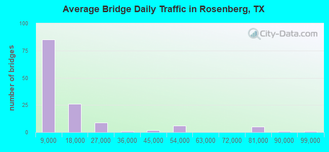
- 1,647,988Total average daily traffic
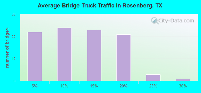
- 156,372Total average daily truck traffic
- National Bridge Inventory (NBI) Registered Bridges for Rosenberg
- No street view available for this location
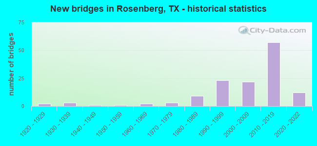
- New bridges - historical statistics
- 21920-1929
- 31930-1939
- 11940-1949
- 11950-1959
- 21960-1969
- 31970-1979
- 91980-1989
- 231990-1999
- 222000-2009
- 572010-2019
- 122020-2022
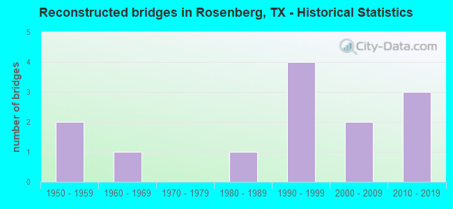
- Reconstructed bridges - Historical Statistics
- 21950-1959
- 11960-1969
- 01970-1979
- 11980-1989
- 41990-1999
- 22000-2009
- 32010-2019
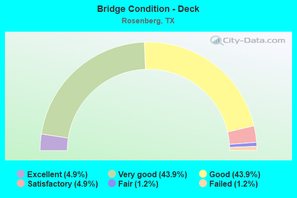
- Bridge Condition - Deck
- 4.9%Excellent
- 43.9%Very good
- 43.9%Good
- 4.9%Satisfactory
- 1.2%Fair
- 1.2%Failed
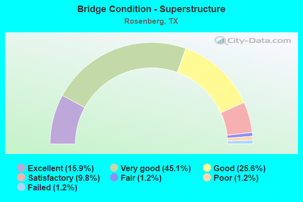
- Bridge Condition - Superstructure
- 15.9%Excellent
- 45.1%Very good
- 25.6%Good
- 9.8%Satisfactory
- 1.2%Fair
- 1.2%Poor
- 1.2%Failed
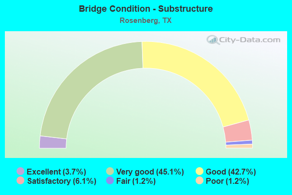
- Bridge Condition - Substructure
- 3.7%Excellent
- 45.1%Very good
- 42.7%Good
- 6.1%Satisfactory
- 1.2%Fair
- 1.2%Poor
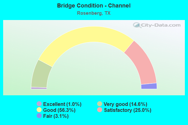
- Bridge Condition - Channel
- 1.0%Excellent
- 14.6%Very good
- 56.3%Good
- 25.0%Satisfactory
- 3.1%Fair
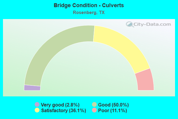
- Bridge Condition - Culverts
- 2.8%Very good
- 50.0%Good
- 36.1%Satisfactory
- 11.1%Poor
Structure Number: 120800002712573, Location: 1.35 MI NE of FM 2218, Route carried "under" structure: City street , Year Built: 2018, Structure Length: 0. m, Average Daily Traffic: 22,600 (year 2019), Truck Traffic: 1%, Features Intersected: IH 69 SBML, Facility Carried by Structure: IH 69 SB ML
Minimum Vertical Clearance: 5.19m (17.03ft), Kilometerpoint: 0.805, Lanes on structure: 8, Material/Design: Prestressed concrete, Design/Construction: Stringer/Multi-beam, Length of Maximum Span: 45.7m (149.9ft)
Minimum Vertical Clearance: 5.19m (17.03ft), Kilometerpoint: 0.805, Lanes on structure: 8, Material/Design: Prestressed concrete, Design/Construction: Stringer/Multi-beam, Length of Maximum Span: 45.7m (149.9ft)
Find on map >> Show street view
Structure Number: 120800002712574, Location: 1.35 MI NE of FM 2218 (Lat: 29.542842, Lng: -95.756314), Route carried "under" structure: City street , Year Built: 2018, Structure Length: 0. m, Average Daily Traffic: 22,600 (year 2011), Truck Traffic: 1%, Features Intersected: IH 69 NBML, Facility Carried by Structure: IH 69 NB ML
Minimum Vertical Clearance: 5.19m (17.03ft), Kilometerpoint: 0.000, Lanes on structure: 8, Material/Design: Prestressed concrete, Design/Construction: Stringer/Multi-beam, Length of Maximum Span: 45.7m (149.9ft)
Find on map >> Show street view
Structure Number: 120800008909002, Location: 4.03 MI W of SH 36 (Lat: 29.523431, Lng: -95.873792), Route carried "under" structure: US 59, Year Built: 2004, Structure Length: 0. m, Average Daily Traffic: 31,369 (year 2018), Truck Traffic: 25%, Features Intersected: US 59, Facility Carried by Structure: Spur 10
Minimum Vertical Clearance: 5.43m (17.81ft), Kilometerpoint: 30.745, Lanes on structure: 4, Lanes under structure: 6, Material/Design: Prestressed concrete, Design/Construction: Stringer/Multi-beam, Length of Maximum Span: 36.0m (118.1ft)
Find on map >> Show street view
Structure Number: 120800018809039, Location: 0.15 MI N OF US 90A (Lat: 29.559833, Lng: -95.808883), Route carried "under" structure: City street , Year Built: 2002, Structure Length: 0. m, Average Daily Traffic: 100 (year 2012), Truck Traffic: 1%, Features Intersected: UP RR, BNSF RR, WALNUT, Facility Carried by Structure: FM 723
Minimum Vertical Clearance: 7.52m (24.67ft), Kilometerpoint: 0.805, Lanes on structure: 2, Lanes under structure: 2, Material/Design: Prestressed concrete, Design/Construction: Stringer/Multi-beam, Length of Maximum Span: 36.0m (118.1ft)