Bridge Statistics for Russellville, Alabama (AL)
Condition, Traffic, Stress, Structural Evaluation, Project Costs
- National Bridge Inventory (NBI) Statistics
- 54Number of bridges
- 456ft / 139mTotal length
- $71,966,000Total costs
- 187,108Total average daily traffic
- 20,259Total average daily truck traffic
- National Bridge Inventory (NBI) Registered Bridges for Russellville
- No street view available for this location
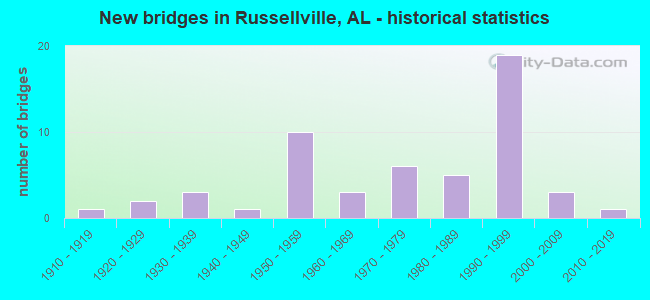
- New bridges - historical statistics
- 11910-1919
- 21920-1929
- 31930-1939
- 11940-1949
- 101950-1959
- 31960-1969
- 61970-1979
- 51980-1989
- 191990-1999
- 32000-2009
- 12010-2019
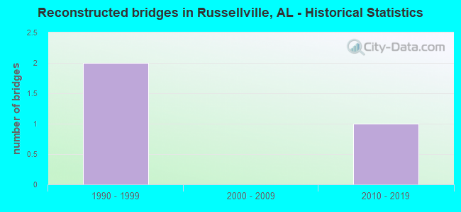
- Reconstructed bridges - Historical Statistics
- 21990-1999
- 02000-2009
- 12010-2019
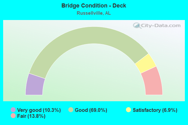
- Bridge Condition - Deck
- 10.3%Very good
- 69.0%Good
- 6.9%Satisfactory
- 13.8%Fair
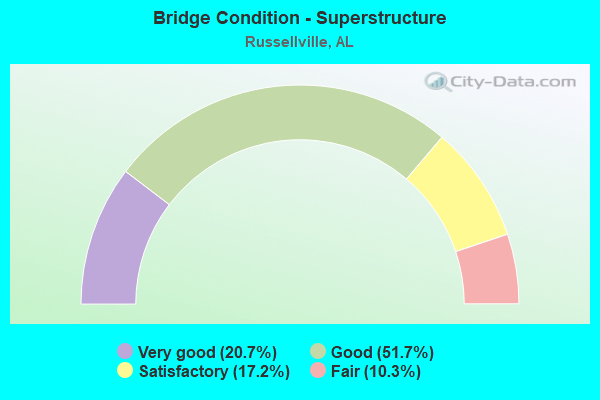
- Bridge Condition - Superstructure
- 20.7%Very good
- 51.7%Good
- 17.2%Satisfactory
- 10.3%Fair
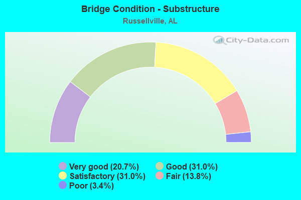
- Bridge Condition - Substructure
- 20.7%Very good
- 31.0%Good
- 31.0%Satisfactory
- 13.8%Fair
- 3.4%Poor
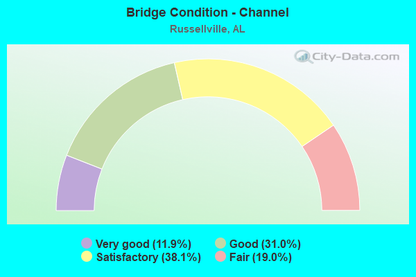
- Bridge Condition - Channel
- 11.9%Very good
- 31.0%Good
- 38.1%Satisfactory
- 19.0%Fair
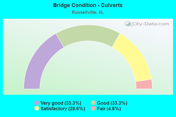
- Bridge Condition - Culverts
- 33.3%Very good
- 33.3%Good
- 28.6%Satisfactory
- 4.8%Fair
Find on map >> Show street view
Structure Number: 16983, Location: 1.3 M E JCT SR 24 & SR 13 (Lat: 34.483556, Lng: -87.712278), Route carried "on" structure: State highway 24, Year Built: 1999, Status: Open, Structure Length: 6.10m (20.01ft), Average Daily Traffic: 3,185 (year 2020), Truck Traffic: 20%, Average Future Daily Traffic: 3,825 (year 2033), Design Load: HS 20, Features Intersected: SLOSS LAKE (PAIN CK)
Minimum Vertical Clearance: 30+ m (98+ ft), Kilometerpoint: 44.362, Lanes on structure: 2, Base Highway Network: Yes, Owner: State Highway Agency, Approaching Roadway Width: 12.0m (39.4ft), Skew: 4 degrees, Material/Design: Prestressed concrete, Design/Construction: Stringer/Multi-beam, Number Of Spans In Main Unit: 1, Number Of Approach Spans: 2, Length of Maximum Span: 30.5m (100.1ft), Curb-To-Curb Width: 12.2m (40.0ft), Out-to-Out Width: 13.1m (43.0ft)
Condition: Deck: Good, Superstructure: Good, Substructure: Good, Channel: Very good, Operating Rating: 71.6 metric tons, Method Used To Determine Operating Rating: Load Factor (LF), Inventory Rating: 42.8 metric tons, Method Used To Determine Inventory Rating: Load Factor (LF), Structural Evaluation: Better than present minimum criteria, Deck Geometry: Better than present minimum criteria, Waterway Adequacy: Equal to present desirable criteria, Approach Roadway Alignment: Equal to present desirable criteria, Length Of Structure Improvement: 7.14m (23.43ft), Designated Inspection Frequency: Every 24 months, Inspection Date: October 2020, Bridge Improvement Cost: $2,055,000, Roadway Improvement Cost: $206,000, Total Project Cost: $2,261,000 ( Estimate for 2022), Deck Structure Type: Concrete Cast-file-Place
Find on map >> Show street view
Structure Number: 16984, Location: 1.3 M E JCT SR 24 & SR 13 (Lat: 34.483194, Lng: -87.711861), Route carried "on" structure: State highway 24, Year Built: 1999, Status: Open, Structure Length: 6.09m (19.98ft), Average Daily Traffic: 3,185 (year 2020), Truck Traffic: 20%, Average Future Daily Traffic: 3,825 (year 2033), Design Load: HS 20, Features Intersected: SLOSS LAKE (Pain CK)
Minimum Vertical Clearance: 30+ m (98+ ft), Kilometerpoint: 44.362, Lanes on structure: 2, Base Highway Network: Yes, Owner: State Highway Agency, Approaching Roadway Width: 12.0m (39.4ft), Skew: 4 degrees, Material/Design: Prestressed concrete, Design/Construction: Stringer/Multi-beam, Number Of Spans In Main Unit: 1, Number Of Approach Spans: 2, Length of Maximum Span: 30.5m (100.1ft), Curb-To-Curb Width: 12.2m (40.0ft), Out-to-Out Width: 13.0m (42.7ft)
Condition: Deck: Good, Superstructure: Good, Substructure: Good, Channel: Very good, Operating Rating: 71.6 metric tons, Method Used To Determine Operating Rating: Load Factor (LF), Inventory Rating: 42.8 metric tons, Method Used To Determine Inventory Rating: Load Factor (LF), Structural Evaluation: Better than present minimum criteria, Deck Geometry: Better than present minimum criteria, Waterway Adequacy: Equal to present desirable criteria, Approach Roadway Alignment: Equal to present desirable criteria, Length Of Structure Improvement: 7.13m (23.39ft), Designated Inspection Frequency: Every 24 months, Inspection Date: October 2020, Bridge Improvement Cost: $2,053,000, Roadway Improvement Cost: $205,000, Total Project Cost: $2,258,000 ( Estimate for 2022), Deck Structure Type: Concrete Cast-file-Place
Find on map >> Show street view
Structure Number: 16985, Location: 0.8 M E JCT SR24 & SR243 (Lat: 34.483222, Lng: -87.710111), Route carried "on" structure: State highway 24, Year Built: 1999, Status: Open, Structure Length: 1.22m (4.00ft), Average Daily Traffic: 6,370 (year 2018), Truck Traffic: 20%, Average Future Daily Traffic: 7,650 (year 2033), Design Load: HS 20, Features Intersected: PAIN CREEK
Minimum Vertical Clearance: 30+ m (98+ ft), Kilometerpoint: 44.542, Lanes on structure: 4, Base Highway Network: Yes, Owner: State Highway Agency, Approaching Roadway Width: 22.2m (72.8ft), Skew: 21 degrees, Material/Design: Concrete, Design/Construction: Culvert, Number Of Spans In Main Unit: 4, Length of Maximum Span: 3.0m (9.8ft)
Condition: Channel: Good, Culverts: Satisfactory, Operating Rating: 88.9 metric tons, Method Used To Determine Operating Rating: Load Factor (LF), Inventory Rating: 88.9 metric tons, Method Used To Determine Inventory Rating: Load Factor (LF), Structural Evaluation: Equal to present minimum criteria, Waterway Adequacy: Equal to present desirable criteria, Approach Roadway Alignment: Equal to present desirable criteria, Length Of Structure Improvement: 1.89m (6.20ft), Designated Inspection Frequency: Every 24 months, Inspection Date: October 2020, Bridge Improvement Cost: $2,284,000, Roadway Improvement Cost: $228,000, Total Project Cost: $2,512,000 ( Estimate for 2022)
Find on map >> Show street view
Structure Number: 17694, Location: 0.1 MI SE JCT. CO. 39 (Lat: 34.560308, Lng: -87.712225), Route carried "on" structure: County highway CG41, Year Built: 2000, Status: Open, Structure Length: 0.98m (3.22ft), Average Daily Traffic: 693 (year 1993), Truck Traffic: 5%, Average Future Daily Traffic: 1,120 (year 2032), Design Load: HS 20, Features Intersected: BROWN CREEK, Facility Carried by Structure: CO. RD. 60
Minimum Vertical Clearance: 30+ m (98+ ft), Kilometerpoint: 0.000, Lanes on structure: 2, Owner: County Highway Agency, Approaching Roadway Width: 7.3m (24.0ft), Skew: 1 degrees, Material/Design: Concrete, Design/Construction: Culvert, Number Of Spans In Main Unit: 3, Length of Maximum Span: 3.0m (9.8ft), Out-to-Out Width: 13.0m (42.7ft)
Condition: Channel: Good, Culverts: Very good, Operating Rating: 67.7 metric tons, Method Used To Determine Operating Rating: Load Factor (LF), Inventory Rating: 40.6 metric tons, Method Used To Determine Inventory Rating: Load Factor (LF), Structural Evaluation: Equal to present desirable criteria, Waterway Adequacy: Equal to present desirable criteria, Approach Roadway Alignment: Equal to present desirable criteria, Length Of Structure Improvement: 1.65m (5.41ft), Designated Inspection Frequency: Every 24 months, Inspection Date: November 2021, Bridge Improvement Cost: $401,000, Roadway Improvement Cost: $40,000, Total Project Cost: $441,000 ( Estimate for 2022)
Find on map >> Show street view
Structure Number: 17844, Location: 4.3 M E JCT SR24 & SR243 (Lat: 34.489361, Lng: -87.650778), Route carried "on" structure: Spur State highway 24, Year Built: 1998, Status: Open, Structure Length: 0.79m (2.59ft), Average Daily Traffic: 4,530 (year 2020), Truck Traffic: 29%, Average Future Daily Traffic: 5,441 (year 2033), Design Load: HS 20, Features Intersected: CREEK
Minimum Vertical Clearance: 30+ m (98+ ft), Kilometerpoint: 51.048, Lanes on structure: 4, Base Highway Network: Yes, Owner: State Highway Agency, Approaching Roadway Width: 22.2m (72.8ft), Skew: 6 degrees, Material/Design: Concrete, Design/Construction: Culvert, Number Of Spans In Main Unit: 3, Length of Maximum Span: 2.4m (7.9ft)
Condition: Channel: Good, Culverts: Satisfactory, Operating Rating: 88.9 metric tons, Method Used To Determine Operating Rating: Load Factor (LF), Inventory Rating: 82.7 metric tons, Method Used To Determine Inventory Rating: Load Factor (LF), Structural Evaluation: Equal to present minimum criteria, Waterway Adequacy: Equal to present desirable criteria, Approach Roadway Alignment: Equal to present desirable criteria, Length Of Structure Improvement: 1.45m (4.76ft), Designated Inspection Frequency: Every 24 months, Inspection Date: October 2020, Bridge Improvement Cost: $3,079,000, Roadway Improvement Cost: $308,000, Total Project Cost: $3,387,000 ( Estimate for 2022)
Find on map >> Show street view
Structure Number: 1903, Location: CO78 1.4 MI E OF CO48JCT (Lat: 34.507217, Lng: -87.636394), Route carried "on" structure: County highway 78, Year Built: 2003, Status: Open, Structure Length: 1.18m (3.87ft), Average Daily Traffic: 379 (year 2003), Truck Traffic: 4%, Average Future Daily Traffic: 661 (year 2036), Design Load: HS 20, Features Intersected: LITTLE MUD CREEK
Minimum Vertical Clearance: 30+ m (98+ ft), Kilometerpoint: 0.010, Lanes on structure: 2, Owner: County Highway Agency, Approaching Roadway Width: 6.1m (20.0ft), Skew: 1 degrees, Material/Design: Concrete continuous, Design/Construction: Culvert, Number Of Spans In Main Unit: 3, Length of Maximum Span: 3.7m (12.1ft)
Condition: Channel: Good, Culverts: Very good, Operating Rating: 86.8 metric tons, Method Used To Determine Operating Rating: Load Factor (LF), Inventory Rating: 52.1 metric tons, Method Used To Determine Inventory Rating: Load Factor (LF), Structural Evaluation: Equal to present desirable criteria, Waterway Adequacy: Equal to present desirable criteria, Approach Roadway Alignment: Equal to present desirable criteria, Length Of Structure Improvement: 1.85m (6.07ft), Designated Inspection Frequency: Every 24 months, Inspection Date: October 2020, Bridge Improvement Cost: $471,000, Roadway Improvement Cost: $47,000, Total Project Cost: $518,000 ( Estimate for 2022), Deck Structure Type: Concrete Cast-file-Place, Wearing Surface/Protective System: Wearing Surface: Bituminous
Find on map >> Show street view
Structure Number: 19032, Location: 0.3 MI W. US 43 CO 64 JCT (Lat: 34.440761, Lng: -87.759331), Route carried "on" structure: County highway 64, Year Built: 2004, Status: Open, Structure Length: 1.76m (5.77ft), Average Daily Traffic: 259 (year 2003), Truck Traffic: 2%, Average Future Daily Traffic: 385 (year 2028), Design Load: HS 20, Features Intersected: ROBINSON CREEK
Minimum Vertical Clearance: 30+ m (98+ ft), Kilometerpoint: 0.010, Lanes on structure: 2, Owner: County Highway Agency, Approaching Roadway Width: 6.1m (20.0ft), Material/Design: Concrete continuous, Design/Construction: Culvert, Number Of Spans In Main Unit: 4, Length of Maximum Span: 4.3m (14.1ft)
Condition: Channel: Very good, Culverts: Very good, Operating Rating: 76.7 metric tons, Method Used To Determine Operating Rating: Load Factor (LF), Inventory Rating: 46.0 metric tons, Method Used To Determine Inventory Rating: Load Factor (LF), Structural Evaluation: Equal to present desirable criteria, Waterway Adequacy: Equal to present desirable criteria, Approach Roadway Alignment: Equal to present desirable criteria, Length Of Structure Improvement: 2.47m (8.10ft), Designated Inspection Frequency: Every 24 months, Inspection Date: September 2021, Bridge Improvement Cost: $627,000, Roadway Improvement Cost: $63,000, Total Project Cost: $690,000 ( Estimate for 2022), Deck Structure Type: Concrete Cast-file-Place, Wearing Surface/Protective System: Wearing Surface: Bituminous
Find on map >> Show street view
Structure Number: 20399, Location: LIGON SPR. S LITTLE EGYPT (Lat: 34.590081, Lng: -87.741706), Route carried "on" structure: County highway 18, Year Built: 1938, Year Reconstructed: 2010, Status: Open, Structure Length: 0.91m (2.99ft), Average Daily Traffic: 343 (year 2006), Truck Traffic: 10%, Average Future Daily Traffic: 510 (year 2038), Design Load: HS 20, Features Intersected: DILLARD BRANCH, Facility Carried by Structure: LIGON SPRINGS RD
Minimum Vertical Clearance: 30.45m (99.90ft), Kilometerpoint: 0.000, Lanes on structure: 2, Owner: County Highway Agency, Approaching Roadway Width: 7.3m (24.0ft), Material/Design: Wood or Timber, Design/Construction: Stringer/Multi-beam, Number Of Spans In Main Unit: 1, Length of Maximum Span: 9.1m (29.9ft), Curb-To-Curb Width: 6.6m (21.7ft), Out-to-Out Width: 6.7m (22.0ft)
Condition: Deck: Very good, Superstructure: Very good, Substructure: Satisfactory, Channel: Satisfactory, Operating Rating: 44.6 metric tons, Method Used To Determine Operating Rating: Allowable Stress (AS), Inventory Rating: 32.3 metric tons, Method Used To Determine Inventory Rating: Allowable Stress (AS), Structural Evaluation: Equal to present minimum criteria, Deck Geometry: Meets minimum limits, Waterway Adequacy: Equal to present minimum criteria, Approach Roadway Alignment: Meets minimum limits, Length Of Structure Improvement: 1.59m (5.22ft), Designated Inspection Frequency: Every 24 months, Inspection Date: June 2020, Bridge Improvement Cost: $228,000, Roadway Improvement Cost: $23,000, Total Project Cost: $251,000 ( Estimate for 2022), Deck Structure Type: Wood or Timber, Wearing Surface/Protective System: Wearing Surface: Bituminous
Find on map >> Show street view
Structure Number: 20548, Location: 3.6 M E JCT SR24 & SR243 (Lat: 34.489611, Lng: -87.663000), Route carried "on" structure: State highway 24, Year Built: 1998, Status: Open, Structure Length: 0.61m (2.00ft), Average Daily Traffic: 4,530 (year 2020), Truck Traffic: 29%, Average Future Daily Traffic: 5,441 (year 2033), Design Load: HS 20, Features Intersected: HARRIS CREEK
Minimum Vertical Clearance: 30+ m (98+ ft), Kilometerpoint: 50.694, Lanes on structure: 4, Base Highway Network: Yes, Owner: State Highway Agency, Approaching Roadway Width: 22.2m (72.8ft), Skew: 25 degrees, Material/Design: Concrete, Design/Construction: Culvert, Number Of Spans In Main Unit: 1, Length of Maximum Span: 6.1m (20.0ft)
Condition: Channel: Satisfactory, Culverts: Good, Operating Rating: 88.9 metric tons, Method Used To Determine Operating Rating: Load Factor (LF), Inventory Rating: 88.9 metric tons, Method Used To Determine Inventory Rating: Load Factor (LF), Structural Evaluation: Better than present minimum criteria, Waterway Adequacy: Equal to present desirable criteria, Approach Roadway Alignment: Equal to present desirable criteria, Length Of Structure Improvement: 1.23m (4.04ft), Designated Inspection Frequency: Every 24 months, Inspection Date: October 2020, Bridge Improvement Cost: $2,490,000, Roadway Improvement Cost: $249,000, Total Project Cost: $2,739,000 ( Estimate for 2022)
Find on map >> Show street view
Structure Number: 21032, Location: 1.8 MI SE JCT CO.49 (Lat: 34.548642, Lng: -87.800450), Route carried "on" structure: County highway 58, Year Built: 2016, Status: Open, Structure Length: 2.53m (8.30ft), Average Daily Traffic: 218 (year 2015), Truck Traffic: 20%, Average Future Daily Traffic: 324 (year 2035), Design Load: HS 20, Features Intersected: TOLLISON CREEK
Minimum Vertical Clearance: 30+ m (98+ ft), Kilometerpoint: 0.010, Lanes on structure: 2, Owner: County Highway Agency, Approaching Roadway Width: 7.3m (24.0ft), Skew: 4 degrees, Material/Design: Concrete, Design/Construction: Culvert, Number Of Spans In Main Unit: 4, Length of Maximum Span: 4.3m (14.1ft), Curb-To-Curb Width: 7.3m (24.0ft), Out-to-Out Width: 9.4m (30.8ft)
Condition: Channel: Very good, Culverts: Very good, Operating Rating: 88.9 metric tons, Method Used To Determine Operating Rating: Load Factor (LF), Inventory Rating: 56.4 metric tons, Method Used To Determine Inventory Rating: Load Factor (LF), Structural Evaluation: Equal to present desirable criteria, Deck Geometry: High priority of replacement, Waterway Adequacy: Superior to present desirable criteria, Approach Roadway Alignment: Equal to present desirable criteria, Length Of Structure Improvement: 3.41m (11.19ft), Designated Inspection Frequency: Every 24 months, Inspection Date: April 2020, Bridge Improvement Cost: $867,000, Roadway Improvement Cost: $87,000, Total Project Cost: $954,000 ( Estimate for 2022), Deck Structure Type: Concrete Cast-file-Place
Find on map >> Show street view
Structure Number: 11421, Location: 0.3 M W JCT SR 24 & SR 13 (Lat: 34.492250, Lng: -87.737139), Route carried "under" structure: City street 43, Year Built: 1975, Structure Length: 0. m, Average Daily Traffic: 1,200 (year 2020), Truck Traffic: 1%, Features Intersected: CITY STREET, Facility Carried by Structure: SR 24
Minimum Vertical Clearance: 6.12m (20.08ft), Kilometerpoint: 0.000, Lanes on structure: 3, Lanes under structure: 2, Material/Design: Steel, Design/Construction: Stringer/Multi-beam, Length of Maximum Span: 21.6m (70.9ft)
Find on map >> Show street view
Structure Number: 16496, Location: 0.3 M W JCT SR 24 & SR 13 (Lat: 34.492178, Lng: -87.736878), Route carried "under" structure: City street 43, Year Built: 1997, Structure Length: 0. m, Average Daily Traffic: 1,200 (year 2020), Truck Traffic: 2%, Features Intersected: CITY STREET, Facility Carried by Structure: SR 24
Minimum Vertical Clearance: 4.60m (15.09ft), Kilometerpoint: 0.000, Lanes on structure: 3, Lanes under structure: 2, Material/Design: Prestressed concrete continuous, Design/Construction: Stringer/Multi-beam, Length of Maximum Span: 21.6m (70.9ft)
Find on map >> Show street view
Structure Number: 16499, Location: JCT SR 24 & SR 13 (Lat: 34.489444, Lng: -87.732194), Route carried "under" structure: US 43, Year Built: 1998, Structure Length: 0. m, Average Daily Traffic: 17,730 (year 2018), Truck Traffic: 9%, Features Intersected: SR 13, Facility Carried by Structure: SR 24
Minimum Vertical Clearance: 5.09m (16.70ft), Kilometerpoint: 472.791, Lanes on structure: 3, Lanes under structure: 9, Material/Design: Prestressed concrete, Design/Construction: Stringer/Multi-beam, Length of Maximum Span: 42.6m (139.8ft)
Find on map >> Show street view
Structure Number: 165, Location: JCT SR 24 & SR 13 (Lat: 34.489694, Lng: -87.731917), Route carried "under" structure: US 43, Year Built: 1998, Structure Length: 0. m, Average Daily Traffic: 17,730 (year 2020), Truck Traffic: 9%, Features Intersected: SR 13, Facility Carried by Structure: SR 24
Minimum Vertical Clearance: 5.80m (19.03ft), Kilometerpoint: 472.822, Lanes on structure: 2, Lanes under structure: 9, Material/Design: Prestressed concrete, Design/Construction: Stringer/Multi-beam, Length of Maximum Span: 42.6m (139.8ft)