Bridge Statistics for Sacramento, California (CA)
Condition, Traffic, Stress, Structural Evaluation, Project Costs
- National Bridge Inventory (NBI) Statistics
- 603Number of bridges
- 12,999ft / 3,962mTotal length
- $16,964,000Total costs
- 28,365,247Total average daily traffic
- 1,863,303Total average daily truck traffic
- National Bridge Inventory (NBI) Registered Bridges for Sacramento
- No street view available for this location
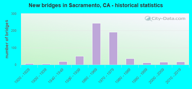
- New bridges - historical statistics
- 11910-1919
- 71920-1929
- 61930-1939
- 191940-1949
- 511950-1959
- 2451960-1969
- 1921970-1979
- 361980-1989
- 131990-1999
- 152000-2009
- 182010-2019

- Reconstructed bridges - Historical Statistics
- 11920-1929
- 01930-1939
- 01940-1949
- 41950-1959
- 151960-1969
- 41970-1979
- 71980-1989
- 81990-1999
- 122000-2009
- 22010-2019


- Bridge Condition - Deck
- 61.5%Good
- 14.3%Satisfactory
- 21.7%Fair
- 2.4%Poor

- Bridge Condition - Superstructure
- 63.4%Good
- 12.7%Satisfactory
- 22.9%Fair
- 1.0%Poor

- Bridge Condition - Substructure
- 0.3%Very good
- 83.2%Good
- 9.6%Satisfactory
- 6.8%Fair

- Bridge Condition - Channel
- 6.3%Excellent
- 53.9%Very good
- 19.5%Good
- 19.5%Satisfactory
- 0.8%Poor

- Bridge Condition - Culverts
- 66.7%Good
- 33.3%Satisfactory
Find on map >> Show street view
Structure Number: 24 0001L, Location: 03-SAC-160-R44.47-SAC (Lat: 38.595919, Lng: -121.477258), Route carried "on" structure: State highway 160, Year Built: 1915, Year Reconstructed: 1934, Status: Open, Structure Length: 18.90m (62.01ft), Average Daily Traffic: 26,500 (year 2009), Truck Traffic: 5%, Average Future Daily Traffic: 42,000 (year 2041), Design Load: HS 15, Features Intersected: AMERICAN RIVER
Minimum Vertical Clearance: 30+ m (98+ ft), Kilometerpoint: 44.470, Lanes on structure: 3, Base Highway Network: Yes (Inventory Route: 1, Subroute: 1), Owner: State Highway Agency, Approaching Roadway Width: 11.6m (38.1ft), Material/Design: Concrete, Design/Construction: Arch - Deck, Number Of Spans In Main Unit: 5, Length of Maximum Span: 40.5m (132.9ft), Curb or Sidewalk Widths: Left: 0.8m (2.6ft), Right: 0.0m, Curb-To-Curb Width: 11.6m (38.1ft), Out-to-Out Width: 17.5m (57.4ft)
Condition: Deck: Satisfactory, Superstructure: Fair, Substructure: Fair, Channel: Good, Operating Rating: 32.4 metric tons, Method Used To Determine Operating Rating: Load Factor (LF), Inventory Rating: 19.4 metric tons, Method Used To Determine Inventory Rating: Load Factor (LF), Structural Evaluation: Meets minimum limits, Deck Geometry: High priority of replacement, Waterway Adequacy: Equal to present desirable criteria, Approach Roadway Alignment: Equal to present desirable criteria, Designated Inspection Frequency: Every 24 months, Underwater Inspection Frequency: Every 60 months, Inspection Date: June 2021, Underwater Inspection Date: September 2017, Deck Structure Type: Concrete Cast-file-Place, Wearing Surface/Protective System: Wearing Surface: Integral Concrete
Find on map >> Show street view
Structure Number: 24 0001R, Location: 03-SAC-160-R44.46-SAC (Lat: 38.595625, Lng: -121.477008), Route carried "on" structure: State highway 160, Year Built: 1968, Status: Open, Structure Length: 20.12m (66.01ft), Average Daily Traffic: 26,500 (year 2009), Truck Traffic: 5%, Average Future Daily Traffic: 42,000 (year 2041), Design Load: HS 20, Features Intersected: AMERICAN RIVER
Minimum Vertical Clearance: 30+ m (98+ ft), Kilometerpoint: 44.460, Lanes on structure: 3, Base Highway Network: Yes (Inventory Route: 1, Subroute: 1), Owner: State Highway Agency, Approaching Roadway Width: 13.4m (44.0ft), Skew: 1 degrees, Material/Design: Concrete continuous, Design/Construction: Box Beam or Girders - Multiple, Number Of Spans In Main Unit: 6, Length of Maximum Span: 40.5m (132.9ft), Curb-To-Curb Width: 13.4m (44.0ft), Out-to-Out Width: 14.0m (45.9ft)
Condition: Deck: Good, Superstructure: Good, Substructure: Satisfactory, Channel: Good, Operating Rating: 43.7 metric tons, Method Used To Determine Operating Rating: Load Factor (LF), Inventory Rating: 26.2 metric tons, Method Used To Determine Inventory Rating: Load Factor (LF), Structural Evaluation: Equal to present minimum criteria, Deck Geometry: Meets minimum limits, Waterway Adequacy: Equal to present desirable criteria, Approach Roadway Alignment: Equal to present desirable criteria, Designated Inspection Frequency: Every 24 months, Underwater Inspection Frequency: Every 60 months, Inspection Date: June 2021, Underwater Inspection Date: September 2017, Deck Structure Type: Concrete Cast-file-Place, Wearing Surface/Protective System: Wearing Surface: Integral Concrete
Find on map >> Show street view
Structure Number: 24 0003, Location: 03-SAC-051-2.61-SAC (Lat: 38.586731, Lng: -121.447767), Route carried "on" structure: State highway 51, Year Built: 1954, Year Reconstructed: 1966, Status: Open, Structure Length: 57.60m (188.98ft), Average Daily Traffic: 195,000 (year 2010), Truck Traffic: 6%, Average Future Daily Traffic: 229,369 (year 2039), Design Load: HS 20, Features Intersected: AMERICAN RIVER
Minimum Vertical Clearance: 30+ m (98+ ft), Kilometerpoint: 2.610, Lanes on structure: 6, Base Highway Network: Yes (, Subroute: 1), Owner: State Highway Agency, Approaching Roadway Width: 27.2m (89.2ft), Skew: 32 degrees, Material/Design: Steel, Design/Construction: Stringer/Multi-beam, Number Of Spans In Main Unit: 8, Number Of Approach Spans: 17, Length of Maximum Span: 38.1m (125.0ft), Curb or Sidewalk Widths: Left: 0.3m (1.0ft), Right: 0.3m (1.0ft), Curb-To-Curb Width: 27.2m (89.2ft), Out-to-Out Width: 28.7m (94.2ft)
Condition: Deck: Fair, Superstructure: Good, Substructure: Satisfactory, Channel: Satisfactory, Operating Rating: 48.0 metric tons, Method Used To Determine Operating Rating: Load and Resistance Factor Rating (LRFR) rating reported by rating factor(RF) method using HL-93 loadings, Inventory Rating: 36.9 metric tons, Method Used To Determine Inventory Rating: Load and Resistance Factor Rating (LRFR) rating reported by rating factor(RF) method using HL-93 loadings, Structural Evaluation: Equal to present minimum criteria, Deck Geometry: Equal to present minimum criteria, Waterway Adequacy: Equal to present desirable criteria, Approach Roadway Alignment: Equal to present desirable criteria, Designated Inspection Frequency: Every 24 months, Critical Feature Inspection Frequency: Every 24 months, Underwater Inspection Frequency: Every 60 months, Other Special Inspection Frequency: Every 48 months, Inspection Date: November 2021, Critical Feature Inspection Date: May 2021, Underwater Inspection Date: October 2021, Other Special Inspection Date: May 2021, Deck Structure Type: Concrete Cast-file-Place, Wearing Surface/Protective System: Wearing Surface: Integral Concrete
Find on map >> Show street view
Structure Number: 24 0004L, Location: 03-SAC-050-L0.01-SAC (Lat: 38.576869, Lng: -121.523919), Route carried "on" structure: Interstate 50, Year Built: 1966, Year Reconstructed: 1971, Status: Open, Structure Length: 193.43m (634.61ft), Average Daily Traffic: 115,500 (year 2009), Truck Traffic: 3%, Average Future Daily Traffic: 130,961 (year 2043), Design Load: HS 20, Features Intersected: SACRAMENTO RIV,I-5,CONNS
Minimum Vertical Clearance: 30+ m (98+ ft), Kilometerpoint: 0.010, Lanes on structure: 3, Lanes under structure: 30, Base Highway Network: Yes (, Subroute: 1), Owner: State Highway Agency, Approaching Roadway Width: 19.2m (63.0ft), Skew: 9 degrees, Navigation Control: Yes ( Vertical Clearance: 16.8m (55.1ft), Horizontal Clearance: 65.2m (213.9ft)), Material/Design: Steel, Design/Construction: Stringer/Multi-beam, Number Of Spans In Main Unit: 40, Length of Maximum Span: 83.8m (274.9ft), Curb-To-Curb Width: 19.2m (63.0ft), Out-to-Out Width: 19.8m (65.0ft)
Condition: Deck: Satisfactory, Superstructure: Good, Substructure: Good, Channel: Very good, Operating Rating: 25.9 metric tons, Method Used To Determine Operating Rating: Load and Resistance Factor Rating (LRFR) rating reported by rating factor(RF) method using HL-93 loadings, Inventory Rating: 20.1 metric tons, Method Used To Determine Inventory Rating: Load and Resistance Factor Rating (LRFR) rating reported by rating factor(RF) method using HL-93 loadings, Structural Evaluation: Somewhat better than minimum adequacy, Deck Geometry: Superior to present desirable criteria, Underclear: High priority of corrective action, Waterway Adequacy: Equal to present desirable criteria, Approach Roadway Alignment: Equal to present desirable criteria, Designated Inspection Frequency: Every 24 months, Critical Feature Inspection Frequency: Every 24 months, Underwater Inspection Frequency: Every 60 months, Other Special Inspection Frequency: Every 48 months, Inspection Date: October 2021, Critical Feature Inspection Date: September 2020, Underwater Inspection Date: July 2019, Other Special Inspection Date: September 2020, Deck Structure Type: Concrete Cast-file-Place, Wearing Surface/Protective System: Wearing Surface: Integral Concrete
Find on map >> Show street view
Structure Number: 24 0004R, Location: 03-SAC-050-L0.01-SAC (Lat: 38.577119, Lng: -121.523869), Route carried "on" structure: Interstate 50, Year Built: 1966, Year Reconstructed: 1971, Status: Open, Structure Length: 193.43m (634.61ft), Average Daily Traffic: 115,500 (year 2009), Truck Traffic: 3%, Average Future Daily Traffic: 130,961 (year 2043), Design Load: HS 20, Features Intersected: SACRAMENTO RIV,I 5,CONNS
Minimum Vertical Clearance: 4.74m (15.55ft), Kilometerpoint: 0.010, Lanes on structure: 3, Lanes under structure: 29, Base Highway Network: Yes (, Subroute: 1), Owner: State Highway Agency, Approaching Roadway Width: 19.2m (63.0ft), Skew: 9 degrees, Navigation Control: Yes ( Vertical Clearance: 16.8m (55.1ft), Horizontal Clearance: 65.2m (213.9ft)), Material/Design: Steel, Design/Construction: Stringer/Multi-beam, Number Of Spans In Main Unit: 40, Length of Maximum Span: 83.8m (274.9ft), Curb-To-Curb Width: 19.2m (63.0ft), Out-to-Out Width: 19.8m (65.0ft)
Condition: Deck: Satisfactory, Superstructure: Good, Substructure: Good, Channel: Very good, Operating Rating: 23.7 metric tons, Method Used To Determine Operating Rating: Load and Resistance Factor Rating (LRFR) rating reported by rating factor(RF) method using HL-93 loadings, Inventory Rating: 18.1 metric tons, Method Used To Determine Inventory Rating: Load and Resistance Factor Rating (LRFR) rating reported by rating factor(RF) method using HL-93 loadings, Structural Evaluation: Meets minimum limits, Deck Geometry: Superior to present desirable criteria, Underclear: Meets minimum limits, Waterway Adequacy: Equal to present desirable criteria, Approach Roadway Alignment: Equal to present desirable criteria, Designated Inspection Frequency: Every 24 months, Critical Feature Inspection Frequency: Every 24 months, Underwater Inspection Frequency: Every 60 months, Other Special Inspection Frequency: Every 48 months, Inspection Date: October 2021, Critical Feature Inspection Date: March 2020, Underwater Inspection Date: July 2019, Other Special Inspection Date: March 2020, Deck Structure Type: Concrete Cast-file-Place, Wearing Surface/Protective System: Wearing Surface: Integral Concrete
Find on map >> Show street view
Structure Number: 24 0016, Location: 03-SAC-099-16.35-SAC (Lat: 38.458158, Lng: -121.410950), Route carried "on" structure: State highway 99, Year Built: 1924, Year Reconstructed: 1955, Status: Open, Structure Length: 1.68m (5.51ft), Average Daily Traffic: 131,000 (year 2009), Truck Traffic: 6%, Average Future Daily Traffic: 213,019 (year 2040), Design Load: HS 20, Features Intersected: STRAWBERRY CREEK
Minimum Vertical Clearance: 30+ m (98+ ft), Kilometerpoint: 16.350, Lanes on structure: 7, Base Highway Network: Yes (, Subroute: 1), Owner: State Highway Agency, Approaching Roadway Width: 57.4m (188.3ft), Skew: 30 degrees, Material/Design: Concrete continuous, Design/Construction: Slab, Number Of Spans In Main Unit: 3, Length of Maximum Span: 5.5m (18.0ft), Curb-To-Curb Width: 57.4m (188.3ft), Out-to-Out Width: 58.4m (191.6ft)
Condition: Deck: Good, Superstructure: Good, Substructure: Satisfactory, Channel: Satisfactory, Operating Rating: 37.9 metric tons, Method Used To Determine Operating Rating: Load Factor (LF), Inventory Rating: 22.7 metric tons, Method Used To Determine Inventory Rating: Load Factor (LF), Structural Evaluation: Somewhat better than minimum adequacy, Deck Geometry: Superior to present desirable criteria, Waterway Adequacy: Equal to present minimum criteria, Approach Roadway Alignment: Better than present minimum criteria, Designated Inspection Frequency: Every 24 months, Inspection Date: January 2022, Deck Structure Type: Concrete Cast-file-Place, Wearing Surface/Protective System: Wearing Surface: Bituminous
Find on map >> Show street view
Structure Number: 24 0016K, Location: 03-SAC-099-16.36-SAC (Lat: 38.457875, Lng: -121.412486), Route carried "on" structure: Ramp State highway 99, Year Built: 1995, Status: Open, Structure Length: 3.23m (10.60ft), Average Daily Traffic: 11,700 (year 2000), Truck Traffic: 16%, Average Future Daily Traffic: 22,402 (year 2042), Design Load: HS 20+Mod, Features Intersected: STRAWBERRY CREEK
Minimum Vertical Clearance: 30+ m (98+ ft), Kilometerpoint: 16.360, Lanes on structure: 3, Owner: State Highway Agency, Approaching Roadway Width: 14.6m (47.9ft), Skew: 4 degrees, Material/Design: Concrete continuous, Design/Construction: Slab, Number Of Spans In Main Unit: 3, Length of Maximum Span: 12.8m (42.0ft), Curb-To-Curb Width: 14.6m (47.9ft), Out-to-Out Width: 15.2m (49.9ft)
Condition: Deck: Satisfactory, Superstructure: Satisfactory, Substructure: Good, Channel: Very good, Operating Rating: 54.1 metric tons, Method Used To Determine Operating Rating: Assigned rating based on Load Factor Design (LFD) reported in metric tons, Inventory Rating: 32.4 metric tons, Method Used To Determine Inventory Rating: Assigned rating based on Load Factor Design (LFD) reported in metric tons, Structural Evaluation: Equal to present minimum criteria, Deck Geometry: Better than present minimum criteria, Waterway Adequacy: Equal to present desirable criteria, Approach Roadway Alignment: Better than present minimum criteria, Designated Inspection Frequency: Every 24 months, Inspection Date: January 2022, Deck Structure Type: Concrete Cast-file-Place
Find on map >> Show street view
Structure Number: 24 0020L, Location: 03-SAC-099-8.40 (Lat: 38.357200, Lng: -121.343344), Route carried "on" structure: State highway 99, Year Built: 1929, Year Reconstructed: 1958, Status: Open, Structure Length: 20.06m (65.81ft), Average Daily Traffic: 31,500 (year 2009), Truck Traffic: 18%, Average Future Daily Traffic: 55,865 (year 2040), Design Load: HS 20, Features Intersected: COSUMNES RIVER
Minimum Vertical Clearance: 30+ m (98+ ft), Kilometerpoint: 8.400, Lanes on structure: 2, Base Highway Network: Yes (, Subroute: 1), Owner: State Highway Agency, Approaching Roadway Width: 8.5m (27.9ft), Skew: 9 degrees, Material/Design: Concrete, Design/Construction: Tee Beam, Number Of Spans In Main Unit: 4, Number Of Approach Spans: 18, Length of Maximum Span: 16.5m (54.1ft), Curb or Sidewalk Widths: Left: 0.6m (2.0ft), Right: 0.6m (2.0ft), Curb-To-Curb Width: 8.5m (27.9ft), Out-to-Out Width: 9.9m (32.5ft)
Condition: Deck: Good, Superstructure: Good, Substructure: Satisfactory, Channel: Very good, Operating Rating: 24.0 metric tons, Method Used To Determine Operating Rating: Load and Resistance Factor Rating (LRFR) rating reported by rating factor(RF) method using HL-93 loadings, Inventory Rating: 16.2 metric tons, Method Used To Determine Inventory Rating: Load and Resistance Factor Rating (LRFR) rating reported by rating factor(RF) method using HL-93 loadings, Structural Evaluation: Meets minimum limits, Deck Geometry: High priority of corrective action, Waterway Adequacy: Equal to present desirable criteria, Approach Roadway Alignment: Equal to present desirable criteria, Designated Inspection Frequency: Every 24 months, Inspection Date: January 2022, Deck Structure Type: Concrete Cast-file-Place, Wearing Surface/Protective System: Wearing Surface: Bituminous
Find on map >> Show street view
Structure Number: 24 0030L, Location: 03-SAC-099-0.13-GAL (Lat: 38.245506, Lng: -121.287958), Route carried "on" structure: State highway 99, Year Built: 1938, Year Reconstructed: 1986, Status: Open, Structure Length: 5.61m (18.41ft), Average Daily Traffic: 29,500 (year 2009), Truck Traffic: 15%, Average Future Daily Traffic: 54,299 (year 2040), Design Load: HS 20+Mod, Features Intersected: NORTH CHANNEL DRY CREEK
Minimum Vertical Clearance: 30+ m (98+ ft), Kilometerpoint: 0.130, Lanes on structure: 2, Base Highway Network: Yes (, Subroute: 1), Owner: State Highway Agency, Approaching Roadway Width: 14.0m (45.9ft), Skew: 3 degrees, Material/Design: Concrete continuous, Design/Construction: Slab, Number Of Spans In Main Unit: 10, Length of Maximum Span: 6.7m (22.0ft), Curb-To-Curb Width: 14.0m (45.9ft), Out-to-Out Width: 15.1m (49.5ft)
Condition: Deck: Good, Superstructure: Good, Substructure: Good, Channel: Satisfactory, Operating Rating: 28.5 metric tons, Method Used To Determine Operating Rating: Load and Resistance Factor Rating (LRFR) rating reported by rating factor(RF) method using HL-93 loadings, Inventory Rating: 22.0 metric tons, Method Used To Determine Inventory Rating: Load and Resistance Factor Rating (LRFR) rating reported by rating factor(RF) method using HL-93 loadings, Structural Evaluation: Somewhat better than minimum adequacy, Deck Geometry: Superior to present desirable criteria, Waterway Adequacy: Equal to present minimum criteria, Approach Roadway Alignment: Equal to present desirable criteria, Designated Inspection Frequency: Every 24 months, Inspection Date: January 2022, Deck Structure Type: Concrete Cast-file-Place
Find on map >> Show street view
Structure Number: 24 0034J, Location: 03-SAC-050-R5.33-SAC (Lat: 38.559861, Lng: -121.379631), Route carried "on" structure: Ramp US 50, Year Built: 2015, Status: Open, Structure Length: 1.11m (3.64ft), Average Daily Traffic: 20,000 (year 2009), Truck Traffic: 6%, Average Future Daily Traffic: 30,503 (year 2037), Design Load: HL 93, Features Intersected: BICYCLE &PEDESTRIAN PATH
Minimum Vertical Clearance: 30+ m (98+ ft), Kilometerpoint: 5.330, Lanes on structure: 5, Base Highway Network: Yes (, Subroute: 1), Owner: State Highway Agency, Approaching Roadway Width: 22.3m (73.2ft), Skew: 9 degrees, Material/Design: Concrete, Design/Construction: Slab, Number Of Spans In Main Unit: 1, Length of Maximum Span: 10.7m (35.1ft), Curb-To-Curb Width: 22.3m (73.2ft), Out-to-Out Width: 23.3m (76.4ft)
Condition: Deck: Satisfactory, Superstructure: Satisfactory, Substructure: Good, Operating Rating: 42.1 metric tons, Method Used To Determine Operating Rating: Assigned ratings based on Load and Resistance Factor Design (LRFD) reported by rating factor (RF) using HL93 loadings, Inventory Rating: 32.4 metric tons, Method Used To Determine Inventory Rating: Assigned ratings based on Load and Resistance Factor Design (LRFD) reported by rating factor (RF) using HL93 loadings, Structural Evaluation: Equal to present minimum criteria, Deck Geometry: Superior to present desirable criteria, Approach Roadway Alignment: Equal to present desirable criteria, Designated Inspection Frequency: Every 48 months, Inspection Date: November 2019, Deck Structure Type: Concrete Cast-file-Place
Find on map >> Show street view
Structure Number: 24 0034K, Location: 03-SAC-050-R5.34-SAC (Lat: 38.559625, Lng: -121.379472), Route carried "on" structure: Ramp US 50, Year Built: 2015, Status: Open, Structure Length: 1.11m (3.64ft), Average Daily Traffic: 30,000 (year 2009), Truck Traffic: 6%, Average Future Daily Traffic: 40,671 (year 2037), Design Load: HL 93, Features Intersected: BICYCLE &PEDESTRIAN PATH
Minimum Vertical Clearance: 30+ m (98+ ft), Kilometerpoint: 5.340, Lanes on structure: 2, Base Highway Network: Yes (, Subroute: 1), Owner: State Highway Agency, Approaching Roadway Width: 12.8m (42.0ft), Skew: 9 degrees, Material/Design: Concrete, Design/Construction: Slab, Number Of Spans In Main Unit: 1, Length of Maximum Span: 10.4m (34.1ft), Curb or Sidewalk Widths: Left: 0.0m, Right: 3.7m (12.1ft), Curb-To-Curb Width: 12.8m (42.0ft), Out-to-Out Width: 17.9m (58.7ft)
Condition: Deck: Satisfactory, Superstructure: Satisfactory, Substructure: Good, Operating Rating: 42.1 metric tons, Method Used To Determine Operating Rating: Assigned ratings based on Load and Resistance Factor Design (LRFD) reported by rating factor (RF) using HL93 loadings, Inventory Rating: 32.4 metric tons, Method Used To Determine Inventory Rating: Assigned ratings based on Load and Resistance Factor Design (LRFD) reported by rating factor (RF) using HL93 loadings, Structural Evaluation: Equal to present minimum criteria, Deck Geometry: Superior to present desirable criteria, Approach Roadway Alignment: Equal to present desirable criteria, Designated Inspection Frequency: Every 48 months, Inspection Date: November 2019, Deck Structure Type: Concrete Cast-file-Place
Find on map >> Show street view
Structure Number: 24 0034T, Location: 03-SAC-050-R5.40-SAC (Lat: 38.557981, Lng: -121.378100), Route carried "on" structure: US 50, Year Built: 2015, Status: Open, Structure Length: 1.11m (3.64ft), Average Daily Traffic: 20,000 (year 2009), Truck Traffic: 6%, Average Future Daily Traffic: 30,503 (year 2037), Design Load: HL 93, Features Intersected: BICYCLE &PEDESTRIAN PATH
Minimum Vertical Clearance: 30+ m (98+ ft), Kilometerpoint: 5.400, Lanes on structure: 2, Base Highway Network: Yes (, Subroute: 1), Owner: State Highway Agency, Approaching Roadway Width: 11.0m (36.1ft), Skew: 9 degrees, Material/Design: Concrete, Design/Construction: Slab, Number Of Spans In Main Unit: 1, Length of Maximum Span: 10.7m (35.1ft), Curb-To-Curb Width: 11.0m (36.1ft), Out-to-Out Width: 11.9m (39.0ft)
Condition: Deck: Good, Superstructure: Good, Substructure: Good, Operating Rating: 42.1 metric tons, Method Used To Determine Operating Rating: Assigned ratings based on Load and Resistance Factor Design (LRFD) reported by rating factor (RF) using HL93 loadings, Inventory Rating: 32.4 metric tons, Method Used To Determine Inventory Rating: Assigned ratings based on Load and Resistance Factor Design (LRFD) reported by rating factor (RF) using HL93 loadings, Structural Evaluation: Better than present minimum criteria, Deck Geometry: Somewhat better than minimum adequacy, Approach Roadway Alignment: Equal to present desirable criteria, Designated Inspection Frequency: Every 48 months, Inspection Date: November 2019, Deck Structure Type: Concrete Cast-file-Place
Find on map >> Show street view
Structure Number: 24 0068L, Location: 03-SAC-005-24.82-SAC (Lat: 38.599400, Lng: -121.504453), Route carried "on" structure: Interstate 5, Year Built: 1968, Status: Open, Structure Length: 84.92m (278.61ft), Average Daily Traffic: 92,500 (year 2015), Truck Traffic: 10%, Average Future Daily Traffic: 130,000 (year 2040), Design Load: HS 20, Features Intersected: AMERICAN RIV, GARDEN HWY
Minimum Vertical Clearance: 30+ m (98+ ft), Kilometerpoint: 24.820, Lanes on structure: 5, Lanes under structure: 7, Base Highway Network: Yes (, Subroute: 1), Owner: State Highway Agency, Approaching Roadway Width: 20.1m (65.9ft), Skew: 9 degrees, Navigation Control: Yes ( Vertical Clearance: 3.0m (9.8ft), Horizontal Clearance: 33.8m (110.9ft)), Material/Design: Concrete continuous, Design/Construction: Box Beam or Girders - Multiple, Number Of Spans In Main Unit: 28, Length of Maximum Span: 36.6m (120.1ft), Curb-To-Curb Width: 20.1m (65.9ft), Out-to-Out Width: 20.7m (67.9ft)
Condition: Deck: Good, Superstructure: Good, Substructure: Satisfactory, Channel: Good, Operating Rating: 38.6 metric tons, Method Used To Determine Operating Rating: Load and Resistance Factor Rating (LRFR) rating reported by rating factor(RF) method using HL-93 loadings, Inventory Rating: 29.8 metric tons, Method Used To Determine Inventory Rating: Load and Resistance Factor Rating (LRFR) rating reported by rating factor(RF) method using HL-93 loadings, Structural Evaluation: Equal to present minimum criteria, Deck Geometry: Meets minimum limits, Underclear: High priority of corrective action, Waterway Adequacy: Equal to present desirable criteria, Approach Roadway Alignment: Equal to present desirable criteria, Designated Inspection Frequency: Every 24 months, Underwater Inspection Frequency: Every 60 months, Inspection Date: November 2021, Underwater Inspection Date: September 2017, Deck Structure Type: Concrete Cast-file-Place, Wearing Surface/Protective System: Wearing Surface: Integral Concrete
Find on map >> Show street view
Structure Number: 24 0068R, Location: 03-SAC-005-24.82-SAC (Lat: 38.599606, Lng: -121.504131), Route carried "on" structure: Interstate 5, Year Built: 1968, Status: Open, Structure Length: 84.92m (278.61ft), Average Daily Traffic: 92,500 (year 2015), Truck Traffic: 10%, Average Future Daily Traffic: 130,000 (year 2040), Design Load: HS 20, Features Intersected: AMERICAN RIV, GARDEN HWY
Minimum Vertical Clearance: 30+ m (98+ ft), Kilometerpoint: 24.820, Lanes on structure: 5, Lanes under structure: 7, Base Highway Network: Yes (, Subroute: 1), Owner: State Highway Agency, Approaching Roadway Width: 20.1m (65.9ft), Skew: 9 degrees, Navigation Control: Yes ( Vertical Clearance: 3.0m (9.8ft), Horizontal Clearance: 33.8m (110.9ft)), Material/Design: Concrete continuous, Design/Construction: Box Beam or Girders - Multiple, Number Of Spans In Main Unit: 28, Length of Maximum Span: 36.6m (120.1ft), Curb-To-Curb Width: 20.1m (65.9ft), Out-to-Out Width: 20.7m (67.9ft)
Condition: Deck: Good, Superstructure: Good, Substructure: Good, Channel: Good, Operating Rating: 39.5 metric tons, Method Used To Determine Operating Rating: Load and Resistance Factor Rating (LRFR) rating reported by rating factor(RF) method using HL-93 loadings, Inventory Rating: 30.5 metric tons, Method Used To Determine Inventory Rating: Load and Resistance Factor Rating (LRFR) rating reported by rating factor(RF) method using HL-93 loadings, Structural Evaluation: Better than present minimum criteria, Deck Geometry: Meets minimum limits, Underclear: High priority of corrective action, Waterway Adequacy: Equal to present desirable criteria, Approach Roadway Alignment: Equal to present desirable criteria, Designated Inspection Frequency: Every 24 months, Underwater Inspection Frequency: Every 60 months, Inspection Date: November 2021, Underwater Inspection Date: September 2017, Deck Structure Type: Concrete Cast-file-Place, Wearing Surface/Protective System: Wearing Surface: Integral Concrete
Find on map >> Show street view
Structure Number: 24 0069L, Location: 03-SAC-005-23.59-SAC (Lat: 38.581811, Lng: -121.503958), Route carried "on" structure: Interstate 5, Year Built: 1969, Status: Open, Structure Length: 95.83m (314.40ft), Average Daily Traffic: 92,500 (year 2015), Truck Traffic: 10%, Average Future Daily Traffic: 129,000 (year 2040), Design Load: HS 20+Mod, Features Intersected: UP RR,BNSF,AMTRAK, I ST
Minimum Vertical Clearance: 30+ m (98+ ft), Kilometerpoint: 23.590, Lanes on structure: 4, Lanes under structure: 10, Base Highway Network: Yes (, Subroute: 1), Owner: State Highway Agency, Approaching Roadway Width: 20.1m (65.9ft), Skew: 9 degrees, Material/Design: Steel, Design/Construction: Stringer/Multi-beam, Number Of Spans In Main Unit: 29, Number Of Approach Spans: 25, Length of Maximum Span: 45.7m (149.9ft), Curb-To-Curb Width: 20.1m (65.9ft), Out-to-Out Width: 20.7m (67.9ft)
Condition: Deck: Good, Superstructure: Good, Substructure: Good, Operating Rating: 29.8 metric tons, Method Used To Determine Operating Rating: Load and Resistance Factor Rating (LRFR) rating reported by rating factor(RF) method using HL-93 loadings, Inventory Rating: 23.0 metric tons, Method Used To Determine Inventory Rating: Load and Resistance Factor Rating (LRFR) rating reported by rating factor(RF) method using HL-93 loadings, Structural Evaluation: Somewhat better than minimum adequacy, Deck Geometry: Equal to present minimum criteria, Underclear: High priority of corrective action, Approach Roadway Alignment: Equal to present desirable criteria, Designated Inspection Frequency: Every 24 months, Critical Feature Inspection Frequency: Every 24 months, Other Special Inspection Frequency: Every 48 months, Inspection Date: November 2021, Critical Feature Inspection Date: May 2021, Other Special Inspection Date: May 2021, Deck Structure Type: Concrete Cast-file-Place, Wearing Surface/Protective System: Wearing Surface: Integral Concrete
Find on map >> Show street view
Structure Number: 24 0069R, Location: 03-SAC-005-23.59-SAC (Lat: 38.581744, Lng: -121.503708), Route carried "on" structure: Interstate 5, Year Built: 1969, Status: Open, Structure Length: 95.83m (314.40ft), Average Daily Traffic: 92,500 (year 2015), Truck Traffic: 10%, Average Future Daily Traffic: 129,000 (year 2040), Design Load: HS 20, Features Intersected: UP RR,BNSF,AMTRAK, I ST
Minimum Vertical Clearance: 30+ m (98+ ft), Kilometerpoint: 23.590, Lanes on structure: 3, Lanes under structure: 13, Base Highway Network: Yes (, Subroute: 1), Owner: State Highway Agency, Approaching Roadway Width: 20.1m (65.9ft), Skew: 9 degrees, Material/Design: Steel, Design/Construction: Stringer/Multi-beam, Number Of Spans In Main Unit: 29, Number Of Approach Spans: 17, Length of Maximum Span: 46.3m (151.9ft), Curb-To-Curb Width: 20.1m (65.9ft), Out-to-Out Width: 20.7m (67.9ft)
Condition: Deck: Good, Superstructure: Good, Substructure: Good, Operating Rating: 27.9 metric tons, Method Used To Determine Operating Rating: Load and Resistance Factor Rating (LRFR) rating reported by rating factor(RF) method using HL-93 loadings, Inventory Rating: 21.7 metric tons, Method Used To Determine Inventory Rating: Load and Resistance Factor Rating (LRFR) rating reported by rating factor(RF) method using HL-93 loadings, Structural Evaluation: Somewhat better than minimum adequacy, Deck Geometry: Superior to present desirable criteria, Underclear: High priority of corrective action, Approach Roadway Alignment: Equal to present desirable criteria, Designated Inspection Frequency: Every 24 months, Critical Feature Inspection Frequency: Every 24 months, Other Special Inspection Frequency: Every 48 months, Inspection Date: November 2021, Critical Feature Inspection Date: May 2021, Other Special Inspection Date: May 2021, Deck Structure Type: Concrete Cast-file-Place, Wearing Surface/Protective System: Wearing Surface: Integral Concrete
Find on map >> Show street view
Structure Number: 24 0093S, Location: 03-SAC-005-23.59-SAC (Lat: 38.581728, Lng: -121.503550), Route carried "on" structure: Ramp Interstate 5, Year Built: 1968, Status: Open, Structure Length: 1.04m (3.41ft), Average Daily Traffic: 12,000 (year 2015), Truck Traffic: 2%, Average Future Daily Traffic: 14,570 (year 2041), Design Load: HS 20, Features Intersected: PEDESTRIAN WALKWAY
Minimum Vertical Clearance: 30+ m (98+ ft), Kilometerpoint: 23.590, Lanes on structure: 2, Owner: State Highway Agency, Approaching Roadway Width: 12.2m (40.0ft), Material/Design: Concrete, Design/Construction: Slab, Number Of Spans In Main Unit: 1, Length of Maximum Span: 10.1m (33.1ft), Curb or Sidewalk Widths: Left: 0.0m, Right: 1.8m (5.9ft), Curb-To-Curb Width: 10.4m (34.1ft), Out-to-Out Width: 12.8m (42.0ft)
Condition: Deck: Good, Superstructure: Good, Substructure: Good, Operating Rating: 99.8 metric tons, Method Used To Determine Operating Rating: Load Factor (LF), Inventory Rating: 75.8 metric tons, Method Used To Determine Inventory Rating: Load Factor (LF), Structural Evaluation: Better than present minimum criteria, Deck Geometry: Better than present minimum criteria, Approach Roadway Alignment: Equal to present desirable criteria, Designated Inspection Frequency: Every 24 months, Inspection Date: Febuary 2021, Deck Structure Type: Concrete Cast-file-Place, Wearing Surface/Protective System: Wearing Surface: Bituminous
Find on map >> Show street view
Structure Number: 24 0100L, Location: 03-SAC-160-R44.65-SAC (Lat: 38.597589, Lng: -121.474692), Route carried "on" structure: State highway 160, Year Built: 1942, Status: Open, Structure Length: 45.60m (149.61ft), Average Daily Traffic: 26,500 (year 2009), Truck Traffic: 5%, Average Future Daily Traffic: 42,000 (year 2041), Design Load: HS 20, Features Intersected: UP RR,BNSF RY,NORTHGATE
Minimum Vertical Clearance: 30+ m (98+ ft), Kilometerpoint: 44.650, Lanes on structure: 2, Lanes under structure: 3, Base Highway Network: Yes (Inventory Route: 1, Subroute: 1), Owner: State Highway Agency, Approaching Roadway Width: 16.8m (55.1ft), Material/Design: Concrete continuous, Design/Construction: Tee Beam, Number Of Spans In Main Unit: 38, Length of Maximum Span: 12.5m (41.0ft), Curb or Sidewalk Widths: Left: 1.3m (4.3ft), Right: 1.3m (4.3ft), Curb-To-Curb Width: 16.8m (55.1ft), Out-to-Out Width: 20.0m (65.6ft)
Condition: Deck: Satisfactory, Superstructure: Satisfactory, Substructure: Good, Channel: Very good, Operating Rating: 48.6 metric tons, Method Used To Determine Operating Rating: Load Factor (LF), Inventory Rating: 29.2 metric tons, Method Used To Determine Inventory Rating: Load Factor (LF), Structural Evaluation: Equal to present minimum criteria, Deck Geometry: Superior to present desirable criteria, Underclear: Meets minimum limits, Waterway Adequacy: Equal to present desirable criteria, Approach Roadway Alignment: Equal to present desirable criteria, Designated Inspection Frequency: Every 24 months, Other Special Inspection Frequency: Every 48 months, Inspection Date: June 2021, Other Special Inspection Date: December 2020, Deck Structure Type: Concrete Cast-file-Place, Wearing Surface/Protective System: Wearing Surface: Integral Concrete
Find on map >> Show street view
Structure Number: 24 0100R, Location: 03-SAC-160-R44.71-SAC (Lat: 38.597744, Lng: -121.473281), Route carried "on" structure: State highway 160, Year Built: 1968, Status: Open, Structure Length: 34.75m (114.01ft), Average Daily Traffic: 26,500 (year 2009), Truck Traffic: 5%, Average Future Daily Traffic: 41,233 (year 2041), Design Load: HS 20, Features Intersected: UP RR,BNSF RY,NORTHGATE
Minimum Vertical Clearance: 30+ m (98+ ft), Kilometerpoint: 44.710, Lanes on structure: 3, Lanes under structure: 3, Base Highway Network: Yes (Inventory Route: 1, Subroute: 1), Owner: State Highway Agency, Approaching Roadway Width: 13.4m (44.0ft), Material/Design: Concrete continuous, Design/Construction: Box Beam or Girders - Multiple, Number Of Spans In Main Unit: 14, Length of Maximum Span: 27.4m (89.9ft), Curb-To-Curb Width: 13.4m (44.0ft), Out-to-Out Width: 14.0m (45.9ft)
Condition: Deck: Good, Superstructure: Good, Substructure: Good, Channel: Very good, Operating Rating: 40.8 metric tons, Method Used To Determine Operating Rating: Load and Resistance Factor Rating (LRFR) rating reported by rating factor(RF) method using HL-93 loadings, Inventory Rating: 30.5 metric tons, Method Used To Determine Inventory Rating: Load and Resistance Factor Rating (LRFR) rating reported by rating factor(RF) method using HL-93 loadings, Structural Evaluation: Better than present minimum criteria, Deck Geometry: Meets minimum limits, Underclear: Superior to present desirable criteria, Waterway Adequacy: Equal to present desirable criteria, Approach Roadway Alignment: Equal to present desirable criteria, Designated Inspection Frequency: Every 24 months, Inspection Date: June 2021, Deck Structure Type: Concrete Cast-file-Place, Wearing Surface/Protective System: Wearing Surface: Integral Concrete
Find on map >> Show street view
Structure Number: 24 0104, Location: 03-SAC-080-M7.13-SAC (Lat: 38.643053, Lng: -121.438394), Route carried "on" structure: City street , Year Built: 1970, Status: Open, Structure Length: 5.90m (19.36ft), Average Daily Traffic: 5,500 (year 2010), Truck Traffic: 10%, Average Future Daily Traffic: 10,364 (year 2043), Design Load: HS 20, Features Intersected: INTERSTATE 80, Facility Carried by Structure: DRY CREEK ROAD
Minimum Vertical Clearance: 30+ m (98+ ft), Kilometerpoint: 0.000, Lanes on structure: 4, Lanes under structure: 6, Owner: State Highway Agency, Approaching Roadway Width: 15.5m (50.9ft), Skew: 1 degrees, Material/Design: Prestressed concrete continuous, Design/Construction: Box Beam or Girders - Multiple, Number Of Spans In Main Unit: 2, Length of Maximum Span: 29.3m (96.1ft), Curb or Sidewalk Widths: Left: 1.5m (4.9ft), Right: 1.5m (4.9ft), Curb-To-Curb Width: 15.5m (50.9ft), Out-to-Out Width: 19.2m (63.0ft)
Condition: Deck: Good, Superstructure: Fair, Substructure: Good, Operating Rating: 42.8 metric tons, Method Used To Determine Operating Rating: Load and Resistance Factor Rating (LRFR) rating reported by rating factor(RF) method using HL-93 loadings, Inventory Rating: 26.9 metric tons, Method Used To Determine Inventory Rating: Load and Resistance Factor Rating (LRFR) rating reported by rating factor(RF) method using HL-93 loadings, Structural Evaluation: Somewhat better than minimum adequacy, Deck Geometry: Meets minimum limits, Underclear: Meets minimum limits, Approach Roadway Alignment: Equal to present desirable criteria, Designated Inspection Frequency: Every 24 months, Inspection Date: January 2021, Deck Structure Type: Concrete Cast-file-Place
Find on map >> Show street view
Structure Number: 24 0105, Location: 03-SAC-080-M7.63-SAC (Lat: 38.643131, Lng: -121.429144), Route carried "on" structure: City street , Year Built: 1970, Status: Open, Structure Length: 7.22m (23.69ft), Average Daily Traffic: 30,000 (year 2010), Truck Traffic: 10%, Average Future Daily Traffic: 42,896 (year 2041), Design Load: HS 20, Features Intersected: INTERSTATE 80, Facility Carried by Structure: RALEY BLVD
Minimum Vertical Clearance: 30+ m (98+ ft), Kilometerpoint: 0.000, Lanes on structure: 4, Lanes under structure: 6, Base Highway Network: Yes, Owner: State Highway Agency, Approaching Roadway Width: 22.3m (73.2ft), Skew: 21 degrees, Material/Design: Prestressed concrete continuous, Design/Construction: Box Beam or Girders - Multiple, Number Of Spans In Main Unit: 2, Length of Maximum Span: 36.1m (118.4ft), Curb or Sidewalk Widths: Left: 1.5m (4.9ft), Right: 1.5m (4.9ft), Curb-To-Curb Width: 22.3m (73.2ft), Out-to-Out Width: 25.9m (85.0ft)
Condition: Deck: Good, Superstructure: Fair, Substructure: Fair, Operating Rating: 56.4 metric tons, Method Used To Determine Operating Rating: Load and Resistance Factor Rating (LRFR) rating reported by rating factor(RF) method using HL-93 loadings, Inventory Rating: 42.8 metric tons, Method Used To Determine Inventory Rating: Load and Resistance Factor Rating (LRFR) rating reported by rating factor(RF) method using HL-93 loadings, Structural Evaluation: Somewhat better than minimum adequacy, Deck Geometry: Superior to present desirable criteria, Underclear: Better than present minimum criteria, Approach Roadway Alignment: Equal to present desirable criteria, Designated Inspection Frequency: Every 24 months, Inspection Date: January 2021, Deck Structure Type: Concrete Cast-file-Place, Wearing Surface/Protective System: Wearing Surface: Bituminous
Find on map >> Show street view
Structure Number: 24 0106, Location: 03-SAC-080-M8.07-SAC (Lat: 38.640000, Lng: -121.421242), Route carried "on" structure: City street , Year Built: 1970, Status: Open, Structure Length: 13.88m (45.54ft), Average Daily Traffic: 5,500 (year 2010), Truck Traffic: 10%, Average Future Daily Traffic: 10,724 (year 2041), Design Load: HS 20, Features Intersected: INTERSTATE 80, Facility Carried by Structure: NORTH AVE
Minimum Vertical Clearance: 30+ m (98+ ft), Kilometerpoint: 0.000, Lanes on structure: 2, Lanes under structure: 6, Owner: State Highway Agency, Approaching Roadway Width: 15.8m (51.8ft), Skew: 5 degrees, Material/Design: Prestressed concrete continuous, Design/Construction: Box Beam or Girders - Multiple, Number Of Spans In Main Unit: 2, Number Of Approach Spans: 2, Length of Maximum Span: 51.4m (168.6ft), Curb or Sidewalk Widths: Left: 1.5m (4.9ft), Right: 1.5m (4.9ft), Curb-To-Curb Width: 15.8m (51.8ft), Out-to-Out Width: 19.5m (64.0ft)
Condition: Deck: Good, Superstructure: Fair, Substructure: Good, Operating Rating: 86.2 metric tons, Method Used To Determine Operating Rating: Load Factor (LF), Inventory Rating: 32.4 metric tons, Method Used To Determine Inventory Rating: Load Factor (LF), Structural Evaluation: Somewhat better than minimum adequacy, Deck Geometry: Superior to present desirable criteria, Underclear: Equal to present minimum criteria, Approach Roadway Alignment: Equal to present desirable criteria, Designated Inspection Frequency: Every 24 months, Inspection Date: January 2021, Deck Structure Type: Concrete Cast-file-Place
Find on map >> Show street view
Structure Number: 24 0108, Location: 03-SAC-080-M6.12-SAC (Lat: 38.641653, Lng: -121.456906), Route carried "on" structure: City street , Year Built: 1970, Status: Open, Structure Length: 5.95m (19.52ft), Average Daily Traffic: 17,000 (year 2010), Truck Traffic: 10%, Average Future Daily Traffic: 21,591 (year 2043), Design Load: HS 20, Features Intersected: INTERSTATE 80, Facility Carried by Structure: NORWOOD AVE
Minimum Vertical Clearance: 30+ m (98+ ft), Kilometerpoint: 0.000, Lanes on structure: 4, Lanes under structure: 6, Base Highway Network: Yes, Owner: State Highway Agency, Approaching Roadway Width: 19.5m (64.0ft), Material/Design: Prestressed concrete continuous, Design/Construction: Box Beam or Girders - Multiple, Number Of Spans In Main Unit: 2, Length of Maximum Span: 30.2m (99.1ft), Curb or Sidewalk Widths: Left: 1.5m (4.9ft), Right: 1.5m (4.9ft), Curb-To-Curb Width: 19.5m (64.0ft), Out-to-Out Width: 23.2m (76.1ft)
Condition: Deck: Fair, Superstructure: Fair, Substructure: Good, Operating Rating: 53.8 metric tons, Method Used To Determine Operating Rating: Load and Resistance Factor Rating (LRFR) rating reported by rating factor(RF) method using HL-93 loadings, Inventory Rating: 35.0 metric tons, Method Used To Determine Inventory Rating: Load and Resistance Factor Rating (LRFR) rating reported by rating factor(RF) method using HL-93 loadings, Structural Evaluation: Somewhat better than minimum adequacy, Deck Geometry: Better than present minimum criteria, Underclear: Meets minimum limits, Approach Roadway Alignment: Equal to present desirable criteria, Designated Inspection Frequency: Every 24 months, Inspection Date: January 2021, Deck Structure Type: Concrete Cast-file-Place
Find on map >> Show street view
Structure Number: 24 0111L, Location: 03-SAC-160-R45.02-SAC (Lat: 38.600175, Lng: -121.468714), Route carried "on" structure: State highway 160, Year Built: 1946, Status: Open, Structure Length: 9.14m (29.99ft), Average Daily Traffic: 18,000 (year 2009), Truck Traffic: 6%, Average Future Daily Traffic: 25,810 (year 2039), Design Load: HS 20, Features Intersected: N160-DEL PASO OFF, LRT
Minimum Vertical Clearance: 30+ m (98+ ft), Kilometerpoint: 45.020, Lanes on structure: 2, Lanes under structure: 1, Base Highway Network: Yes (Inventory Route: 1, Subroute: 1), Owner: State Highway Agency, Approaching Roadway Width: 8.7m (28.5ft), Skew: 6 degrees, Material/Design: Concrete continuous, Design/Construction: Box Beam or Girders - Multiple, Number Of Spans In Main Unit: 6, Length of Maximum Span: 21.9m (71.9ft), Curb or Sidewalk Widths: Left: 0.6m (2.0ft), Right: 0.6m (2.0ft), Curb-To-Curb Width: 8.7m (28.5ft), Out-to-Out Width: 9.7m (31.8ft)
Condition: Deck: Good, Superstructure: Good, Substructure: Good, Operating Rating: 61.6 metric tons, Method Used To Determine Operating Rating: Load Factor (LF), Inventory Rating: 36.9 metric tons, Method Used To Determine Inventory Rating: Load Factor (LF), Structural Evaluation: Better than present minimum criteria, Deck Geometry: High priority of corrective action, Underclear: High priority of corrective action, Approach Roadway Alignment: Better than present minimum criteria, Designated Inspection Frequency: Every 48 months, Inspection Date: June 2019, Deck Structure Type: Concrete Cast-file-Place, Wearing Surface/Protective System: Wearing Surface: Integral Concrete
Find on map >> Show street view
Structure Number: 24 0112, Location: 03-SAC-160-45.60-SAC (Lat: 38.599975, Lng: -121.457908), Route carried "on" structure: City street , Year Built: 1947, Status: Open, Structure Length: 4.97m (16.31ft), Average Daily Traffic: 6,000 (year 2009), Truck Traffic: 5%, Average Future Daily Traffic: 7,884 (year 2041), Design Load: HS 20, Features Intersected: STATE ROUTE 160, Facility Carried by Structure: CANTERBURY ROAD
Minimum Vertical Clearance: 30+ m (98+ ft), Kilometerpoint: 0.000, Lanes on structure: 2, Lanes under structure: 4, Owner: State Highway Agency, Approaching Roadway Width: 7.9m (25.9ft), Material/Design: Concrete continuous, Design/Construction: Box Beam or Girders - Multiple, Number Of Spans In Main Unit: 4, Length of Maximum Span: 14.6m (47.9ft), Curb or Sidewalk Widths: Left: 1.1m (3.6ft), Right: 1.1m (3.6ft), Curb-To-Curb Width: 7.9m (25.9ft), Out-to-Out Width: 10.6m (34.8ft)
Condition: Deck: Satisfactory, Superstructure: Satisfactory, Substructure: Good, Operating Rating: 35.0 metric tons, Method Used To Determine Operating Rating: Load and Resistance Factor Rating (LRFR) rating reported by rating factor(RF) method using HL-93 loadings, Inventory Rating: 26.9 metric tons, Method Used To Determine Inventory Rating: Load and Resistance Factor Rating (LRFR) rating reported by rating factor(RF) method using HL-93 loadings, Structural Evaluation: Equal to present minimum criteria, Deck Geometry: High priority of replacement, Underclear: High priority of corrective action, Approach Roadway Alignment: Equal to present desirable criteria, Designated Inspection Frequency: Every 24 months, Inspection Date: June 2021, Deck Structure Type: Concrete Cast-file-Place, Wearing Surface/Protective System: Wearing Surface: Bituminous
Find on map >> Show street view
Structure Number: 24 0113, Location: 03-SAC-160-46.16-SAC (Lat: 38.600406, Lng: -121.447817), Route carried "on" structure: City street , Year Built: 1946, Status: Open, Structure Length: 6.22m (20.41ft), Average Daily Traffic: 6,000 (year 2009), Truck Traffic: 5%, Average Future Daily Traffic: 7,728 (year 2041), Design Load: HS 20, Features Intersected: STATE ROUTE 160, Facility Carried by Structure: LEISURE LANE
Minimum Vertical Clearance: 30+ m (98+ ft), Kilometerpoint: 0.000, Lanes on structure: 2, Lanes under structure: 4, Owner: State Highway Agency, Approaching Roadway Width: 8.5m (27.9ft), Skew: 9 degrees, Material/Design: Concrete continuous, Design/Construction: Box Beam or Girders - Multiple, Number Of Spans In Main Unit: 4, Length of Maximum Span: 15.2m (49.9ft), Curb or Sidewalk Widths: Left: 1.5m (4.9ft), Right: 0.3m (1.0ft), Curb-To-Curb Width: 8.5m (27.9ft), Out-to-Out Width: 11.3m (37.1ft)
Condition: Deck: Fair, Superstructure: Good, Substructure: Good, Operating Rating: 69.3 metric tons, Method Used To Determine Operating Rating: Load and Resistance Factor Rating (LRFR) rating reported by rating factor(RF) method using HL-93 loadings, Inventory Rating: 53.5 metric tons, Method Used To Determine Inventory Rating: Load and Resistance Factor Rating (LRFR) rating reported by rating factor(RF) method using HL-93 loadings, Structural Evaluation: Better than present minimum criteria, Deck Geometry: Meets minimum limits, Underclear: High priority of corrective action, Approach Roadway Alignment: Somewhat better than minimum adequacy, Designated Inspection Frequency: Every 24 months, Inspection Date: June 2021, Deck Structure Type: Concrete Cast-file-Place
Find on map >> Show street view
Structure Number: 24 0115L, Location: 03-SAC-051-4.02L-SAC (Lat: 38.603467, Lng: -121.435075), Route carried "on" structure: State highway 51, Year Built: 1946, Status: Open, Structure Length: 3.20m (10.50ft), Average Daily Traffic: 100,000 (year 2010), Truck Traffic: 6%, Average Future Daily Traffic: 226,161 (year 2039), Design Load: HS 20, Features Intersected: ARDEN WAY
Minimum Vertical Clearance: 30+ m (98+ ft), Kilometerpoint: 4.020, Lanes on structure: 6, Lanes under structure: 5, Base Highway Network: Yes (, Subroute: 1), Owner: State Highway Agency, Approaching Roadway Width: 32.0m (105.0ft), Skew: 20 degrees, Material/Design: Concrete continuous, Design/Construction: Slab, Number Of Spans In Main Unit: 5, Length of Maximum Span: 11.0m (36.1ft), Curb-To-Curb Width: 32.0m (105.0ft), Out-to-Out Width: 33.2m (108.9ft)
Condition: Deck: Satisfactory, Superstructure: Satisfactory, Substructure: Good, Operating Rating: 63.2 metric tons, Method Used To Determine Operating Rating: Load Factor (LF), Inventory Rating: 37.9 metric tons, Method Used To Determine Inventory Rating: Load Factor (LF), Structural Evaluation: Equal to present minimum criteria, Deck Geometry: Superior to present desirable criteria, Underclear: High priority of corrective action, Approach Roadway Alignment: Equal to present desirable criteria, Designated Inspection Frequency: Every 48 months, Inspection Date: November 2019, Deck Structure Type: Concrete Cast-file-Place, Wearing Surface/Protective System: Wearing Surface: Integral Concrete
Find on map >> Show street view
Structure Number: 24 0115R, Location: 03-SAC-051-4.06R-SAC (Lat: 38.603147, Lng: -121.434444), Route carried "on" structure: State highway 51, Year Built: 1954, Year Reconstructed: 1996, Status: Open, Structure Length: 5.09m (16.70ft), Average Daily Traffic: 100,000 (year 2010), Truck Traffic: 6%, Average Future Daily Traffic: 227,672 (year 2039), Design Load: HS 20+Mod, Features Intersected: ARDEN WAY
Minimum Vertical Clearance: 30+ m (98+ ft), Kilometerpoint: 4.060, Lanes on structure: 5, Lanes under structure: 4, Base Highway Network: Yes (, Subroute: 1), Owner: State Highway Agency, Approaching Roadway Width: 39.4m (129.3ft), Skew: 29 degrees, Material/Design: Concrete continuous, Design/Construction: Slab, Number Of Spans In Main Unit: 3, Length of Maximum Span: 15.8m (51.8ft), Curb-To-Curb Width: 39.4m (129.3ft), Out-to-Out Width: 40.4m (132.5ft)
Condition: Deck: Fair, Superstructure: Good, Substructure: Good, Operating Rating: 59.3 metric tons, Method Used To Determine Operating Rating: Load Factor (LF), Inventory Rating: 32.4 metric tons, Method Used To Determine Inventory Rating: Load Factor (LF), Structural Evaluation: Better than present minimum criteria, Deck Geometry: Superior to present desirable criteria, Underclear: High priority of corrective action, Approach Roadway Alignment: Equal to present desirable criteria, Designated Inspection Frequency: Every 24 months, Inspection Date: November 2021, Deck Structure Type: Concrete Cast-file-Place, Wearing Surface/Protective System: Wearing Surface: Integral Concrete
Find on map >> Show street view
Structure Number: 24 0116, Location: 03-SAC-051-4.74-SAC (Lat: 38.611158, Lng: -121.427281), Route carried "on" structure: City street , Year Built: 1978, Status: Open, Structure Length: 8.50m (27.89ft), Average Daily Traffic: 42,000 (year 2010), Truck Traffic: 2%, Average Future Daily Traffic: 68,326 (year 2039), Design Load: HS 20+Mod, Features Intersected: STATE ROUTE 51, Facility Carried by Structure: EL CAMINO AVE
Minimum Vertical Clearance: 30+ m (98+ ft), Kilometerpoint: 0.000, Lanes on structure: 4, Lanes under structure: 10, Base Highway Network: Yes, Owner: State Highway Agency, Approaching Roadway Width: 24.2m (79.4ft), Skew: 4 degrees, Material/Design: Prestressed concrete continuous, Design/Construction: Box Beam or Girders - Single/Spread, Number Of Spans In Main Unit: 2, Length of Maximum Span: 43.0m (141.1ft), Curb or Sidewalk Widths: Left: 1.5m (4.9ft), Right: 1.5m (4.9ft), Curb-To-Curb Width: 24.2m (79.4ft), Out-to-Out Width: 27.9m (91.5ft)
Condition: Deck: Satisfactory, Superstructure: Good, Substructure: Good, Operating Rating: 54.1 metric tons, Method Used To Determine Operating Rating: Assigned rating based on Load Factor Design (LFD) reported in metric tons, Inventory Rating: 32.4 metric tons, Method Used To Determine Inventory Rating: Assigned rating based on Load Factor Design (LFD) reported in metric tons, Structural Evaluation: Better than present minimum criteria, Deck Geometry: Superior to present desirable criteria, Underclear: Meets minimum limits, Approach Roadway Alignment: Equal to present desirable criteria, Designated Inspection Frequency: Every 24 months, Inspection Date: November 2021, Deck Structure Type: Concrete Cast-file-Place
Find on map >> Show street view
Structure Number: 24 0117, Location: 03-SAC-051-5.50-SAC (Lat: 38.620056, Lng: -121.419758), Route carried "on" structure: City street , Year Built: 1947, Status: Open, Structure Length: 3.66m (12.01ft), Average Daily Traffic: 40,000 (year 2010), Truck Traffic: 2%, Average Future Daily Traffic: 51,349 (year 2040), Design Load: HS 20, Features Intersected: STATE ROUTE 51, Facility Carried by Structure: MARCONI AVE
Minimum Vertical Clearance: 30+ m (98+ ft), Kilometerpoint: 0.000, Lanes on structure: 4, Lanes under structure: 6, Base Highway Network: Yes, Owner: State Highway Agency, Approaching Roadway Width: 15.2m (49.9ft), Skew: 2 degrees, Material/Design: Concrete continuous, Design/Construction: Box Beam or Girders - Multiple, Number Of Spans In Main Unit: 2, Length of Maximum Span: 17.7m (58.1ft), Curb or Sidewalk Widths: Left: 1.3m (4.3ft), Right: 1.3m (4.3ft), Curb-To-Curb Width: 15.2m (49.9ft), Out-to-Out Width: 18.3m (60.0ft)
Condition: Deck: Satisfactory, Superstructure: Fair, Substructure: Good, Operating Rating: 88.5 metric tons, Method Used To Determine Operating Rating: Load Factor (LF), Inventory Rating: 53.5 metric tons, Method Used To Determine Inventory Rating: Load Factor (LF), Structural Evaluation: Somewhat better than minimum adequacy, Deck Geometry: High priority of corrective action, Underclear: High priority of corrective action, Approach Roadway Alignment: Equal to present desirable criteria, Designated Inspection Frequency: Every 24 months, Inspection Date: March 2021, Deck Structure Type: Concrete Cast-file-Place
Find on map >> Show street view
Structure Number: 24 0118, Location: 03-SAC-160-46.25-SAC (Lat: 38.600406, Lng: -121.446147), Route carried "on" structure: City street , Year Built: 1947, Status: Open, Structure Length: 5.39m (17.68ft), Average Daily Traffic: 5,000 (year 2009), Truck Traffic: 10%, Average Future Daily Traffic: 6,182 (year 2041), Design Load: HS 20, Features Intersected: STATE ROUTE 160, Facility Carried by Structure: TRIBUTE ROAD
Minimum Vertical Clearance: 30+ m (98+ ft), Kilometerpoint: 0.000, Lanes on structure: 2, Lanes under structure: 4, Owner: State Highway Agency, Approaching Roadway Width: 8.5m (27.9ft), Material/Design: Concrete continuous, Design/Construction: Box Beam or Girders - Multiple, Number Of Spans In Main Unit: 4, Length of Maximum Span: 14.6m (47.9ft), Curb or Sidewalk Widths: Left: 0.5m (1.6ft), Right: 0.5m (1.6ft), Curb-To-Curb Width: 8.5m (27.9ft), Out-to-Out Width: 9.9m (32.5ft)
Condition: Deck: Satisfactory, Superstructure: Good, Substructure: Good, Operating Rating: 18.8 metric tons, Method Used To Determine Operating Rating: Load and Resistance Factor Rating (LRFR) rating reported by rating factor(RF) method using HL-93 loadings, Inventory Rating: 14.3 metric tons, Method Used To Determine Inventory Rating: Load and Resistance Factor Rating (LRFR) rating reported by rating factor(RF) method using HL-93 loadings, Structural Evaluation: Meets minimum limits, Deck Geometry: Meets minimum limits, Underclear: High priority of corrective action, Approach Roadway Alignment: Equal to present desirable criteria, Designated Inspection Frequency: Every 24 months, Inspection Date: June 2021, Deck Structure Type: Concrete Cast-file-Place
Find on map >> Show street view
Structure Number: 24 012, Location: 03-SAC-050-16.75 (Lat: 38.639750, Lng: -121.197492), Route carried "on" structure: US 50, Year Built: 1962, Year Reconstructed: 2005, Status: Open, Structure Length: 11.25m (36.91ft), Average Daily Traffic: 115,000 (year 2009), Truck Traffic: 6%, Average Future Daily Traffic: 200,261 (year 2038), Design Load: HS 20, Features Intersected: UP RR, FOLSOM BLVD
Minimum Vertical Clearance: 30+ m (98+ ft), Kilometerpoint: 16.750, Lanes on structure: 7, Lanes under structure: 6, Base Highway Network: Yes (, Subroute: 1), Owner: State Highway Agency, Approaching Roadway Width: 41.1m (134.8ft), Skew: 34 degrees, Material/Design: Concrete continuous, Design/Construction: Box Beam or Girders - Multiple, Number Of Spans In Main Unit: 5, Length of Maximum Span: 25.3m (83.0ft), Curb or Sidewalk Widths: Left: 0.6m (2.0ft), Right: 0.0m, Curb-To-Curb Width: 41.1m (134.8ft), Out-to-Out Width: 43.1m (141.4ft)
Condition: Deck: Good, Superstructure: Good, Substructure: Good, Operating Rating: 42.1 metric tons, Method Used To Determine Operating Rating: Field evaluation and documented engineering judgment, Inventory Rating: 32.4 metric tons, Method Used To Determine Inventory Rating: Field evaluation and documented engineering judgment, Structural Evaluation: Better than present minimum criteria, Deck Geometry: Superior to present desirable criteria, Underclear: Meets minimum limits, Approach Roadway Alignment: Equal to present desirable criteria, Length Of Structure Improvement: 11.25m (36.91ft), Designated Inspection Frequency: Every 48 months, Inspection Date: October 2020, Deck Structure Type: Concrete Cast-file-Place, Wearing Surface/Protective System: Wearing Surface: Bituminous
Find on map >> Show street view
Structure Number: 24 0123, Location: 03-SAC-051-6.79-SAC (Lat: 38.630947, Lng: -121.401514), Route carried "on" structure: City street , Year Built: 1954, Year Reconstructed: 1975, Status: Open, Structure Length: 3.57m (11.71ft), Average Daily Traffic: 15,000 (year 2010), Truck Traffic: 2%, Average Future Daily Traffic: 20,540 (year 2036), Design Load: HS 20, Features Intersected: STATE ROUTE 51, Facility Carried by Structure: FULTON AVE
Minimum Vertical Clearance: 30+ m (98+ ft), Kilometerpoint: 0.000, Lanes on structure: 3, Lanes under structure: 6, Owner: State Highway Agency, Approaching Roadway Width: 11.3m (37.1ft), Skew: 2 degrees, Material/Design: Concrete continuous, Design/Construction: Slab, Number Of Spans In Main Unit: 2, Length of Maximum Span: 17.4m (57.1ft), Curb or Sidewalk Widths: Left: 0.0m, Right: 1.9m (6.2ft), Curb-To-Curb Width: 11.3m (37.1ft), Out-to-Out Width: 13.8m (45.3ft)
Condition: Deck: Good, Superstructure: Good, Substructure: Good, Operating Rating: 99.8 metric tons, Method Used To Determine Operating Rating: Load Factor (LF), Inventory Rating: 66.7 metric tons, Method Used To Determine Inventory Rating: Load Factor (LF), Structural Evaluation: Better than present minimum criteria, Deck Geometry: High priority of replacement, Underclear: High priority of corrective action, Approach Roadway Alignment: Equal to present minimum criteria, Designated Inspection Frequency: Every 48 months, Inspection Date: March 2019, Deck Structure Type: Concrete Cast-file-Place
Find on map >> Show street view
Structure Number: 24 0124K, Location: 03-SAC-051-7.70-SAC (Lat: 38.636797, Lng: -121.386781), Route carried "on" structure: Ramp State highway 51, Year Built: 1954, Status: Open, Structure Length: 4.36m (14.30ft), Average Daily Traffic: 4,500 (year 2010), Truck Traffic: 2%, Average Future Daily Traffic: 5,256 (year 2039), Design Load: HS 20, Features Intersected: STATE ROUTE 51
Minimum Vertical Clearance: 30+ m (98+ ft), Kilometerpoint: 7.700, Lanes on structure: 1, Lanes under structure: 6, Owner: State Highway Agency, Approaching Roadway Width: 6.7m (22.0ft), Skew: 4 degrees, Material/Design: Concrete continuous, Design/Construction: Box Beam or Girders - Multiple, Number Of Spans In Main Unit: 2, Length of Maximum Span: 21.9m (71.9ft), Curb or Sidewalk Widths: Left: 0.6m (2.0ft), Right: 0.6m (2.0ft), Curb-To-Curb Width: 6.7m (22.0ft), Out-to-Out Width: 8.1m (26.6ft)
Condition: Deck: Good, Superstructure: Satisfactory, Substructure: Satisfactory, Operating Rating: 51.8 metric tons, Method Used To Determine Operating Rating: Load and Resistance Factor Rating (LRFR) rating reported by rating factor(RF) method using HL-93 loadings, Inventory Rating: 37.3 metric tons, Method Used To Determine Inventory Rating: Load and Resistance Factor Rating (LRFR) rating reported by rating factor(RF) method using HL-93 loadings, Structural Evaluation: Equal to present minimum criteria, Deck Geometry: Equal to present minimum criteria, Underclear: High priority of corrective action, Approach Roadway Alignment: Better than present minimum criteria, Designated Inspection Frequency: Every 24 months, Inspection Date: November 2021, Deck Structure Type: Concrete Cast-file-Place, Wearing Surface/Protective System: Wearing Surface: Integral Concrete
Find on map >> Show street view
Structure Number: 24 0125L, Location: 03-SAC-051-7.99-SAC (Lat: 38.640144, Lng: -121.383156), Route carried "on" structure: City street , Year Built: 1985, Status: Open, Structure Length: 5.85m (19.19ft), Average Daily Traffic: 30,000 (year 2010), Truck Traffic: 2%, Average Future Daily Traffic: 42,048 (year 2039), Design Load: HS 20+Mod, Features Intersected: STATE ROUTE 51 & RAMP, Facility Carried by Structure: WATT AVE NB
Minimum Vertical Clearance: 30+ m (98+ ft), Kilometerpoint: 0.000, Lanes on structure: 3, Lanes under structure: 6, Base Highway Network: Yes, Owner: State Highway Agency, Approaching Roadway Width: 15.4m (50.5ft), Skew: 4 degrees, Material/Design: Prestressed concrete continuous, Design/Construction: Box Beam or Girders - Multiple, Number Of Spans In Main Unit: 2, Length of Maximum Span: 31.7m (104.0ft), Curb or Sidewalk Widths: Left: 0.0m, Right: 1.5m (4.9ft), Curb-To-Curb Width: 15.4m (50.5ft), Out-to-Out Width: 17.5m (57.4ft)
Condition: Deck: Good, Superstructure: Good, Substructure: Satisfactory, Operating Rating: 54.1 metric tons, Method Used To Determine Operating Rating: Field evaluation and documented engineering judgment, Inventory Rating: 32.4 metric tons, Method Used To Determine Inventory Rating: Field evaluation and documented engineering judgment, Structural Evaluation: Equal to present minimum criteria, Deck Geometry: Equal to present minimum criteria, Underclear: High priority of corrective action, Approach Roadway Alignment: Equal to present desirable criteria, Designated Inspection Frequency: Every 24 months, Inspection Date: November 2021, Deck Structure Type: Concrete Cast-file-Place
Find on map >> Show street view
Structure Number: 24 0125R, Location: 03-SAC-051-7.97-SAC (Lat: 38.639972, Lng: -121.383386), Route carried "on" structure: City street , Year Built: 1954, Status: Open, Structure Length: 5.49m (18.01ft), Average Daily Traffic: 100,000 (year 2010), Truck Traffic: 10%, Average Future Daily Traffic: 172,727 (year 2039), Design Load: HS 20, Features Intersected: STATE ROUTE 51 & RAMP, Facility Carried by Structure: WATT AVE SB
Minimum Vertical Clearance: 30+ m (98+ ft), Kilometerpoint: 0.000, Lanes on structure: 3, Lanes under structure: 6, Base Highway Network: Yes, Owner: State Highway Agency, Approaching Roadway Width: 15.8m (51.8ft), Skew: 4 degrees, Material/Design: Concrete continuous, Design/Construction: Box Beam or Girders - Multiple, Number Of Spans In Main Unit: 2, Length of Maximum Span: 29.9m (98.1ft), Curb or Sidewalk Widths: Left: 0.0m, Right: 1.4m (4.6ft), Curb-To-Curb Width: 15.8m (51.8ft), Out-to-Out Width: 18.0m (59.1ft)
Condition: Deck: Good, Superstructure: Good, Substructure: Good, Operating Rating: 54.1 metric tons, Method Used To Determine Operating Rating: Load and Resistance Factor Rating (LRFR) rating reported by rating factor(RF) method using HL-93 loadings, Inventory Rating: 39.2 metric tons, Method Used To Determine Inventory Rating: Load and Resistance Factor Rating (LRFR) rating reported by rating factor(RF) method using HL-93 loadings, Structural Evaluation: Better than present minimum criteria, Deck Geometry: Better than present minimum criteria, Underclear: High priority of corrective action, Approach Roadway Alignment: Equal to present desirable criteria, Designated Inspection Frequency: Every 24 months, Inspection Date: November 2021, Deck Structure Type: Concrete Cast-file-Place, Wearing Surface/Protective System: Wearing Surface: Bituminous
Find on map >> Show street view
Structure Number: 24 0126, Location: 03-SAC-051-8.06-SAC (Lat: 38.640703, Lng: -121.382033), Route carried "on" structure: State highway 51, Year Built: 1954, Year Reconstructed: 1968, Status: Open, Structure Length: 3.12m (10.24ft), Average Daily Traffic: 145,000 (year 2010), Truck Traffic: 6%, Average Future Daily Traffic: 195,520 (year 2039), Design Load: HS 20, Features Intersected: ARCADE CREEK
Minimum Vertical Clearance: 30+ m (98+ ft), Kilometerpoint: 8.060, Lanes on structure: 6, Base Highway Network: Yes (, Subroute: 1), Owner: State Highway Agency, Approaching Roadway Width: 32.3m (106.0ft), Skew: 31 degrees, Material/Design: Concrete continuous, Design/Construction: Slab, Number Of Spans In Main Unit: 3, Length of Maximum Span: 12.2m (40.0ft), Curb or Sidewalk Widths: Left: 0.0m, Right: 0.6m (2.0ft), Curb-To-Curb Width: 32.3m (106.0ft), Out-to-Out Width: 34.2m (112.2ft)
Condition: Deck: Good, Superstructure: Good, Substructure: Good, Channel: Very good, Operating Rating: 62.5 metric tons, Method Used To Determine Operating Rating: Load Factor (LF), Inventory Rating: 37.6 metric tons, Method Used To Determine Inventory Rating: Load Factor (LF), Structural Evaluation: Better than present minimum criteria, Deck Geometry: Superior to present desirable criteria, Waterway Adequacy: Equal to present minimum criteria, Approach Roadway Alignment: Equal to present desirable criteria, Designated Inspection Frequency: Every 24 months, Inspection Date: November 2021, Deck Structure Type: Concrete Cast-file-Place, Wearing Surface/Protective System: Wearing Surface: Bituminous