Bridge Statistics for Saginaw, Michigan (MI)
Condition, Traffic, Stress, Structural Evaluation, Project Costs
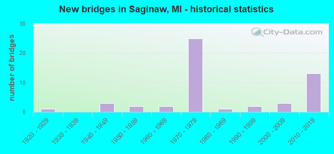
- New bridges - historical statistics
- 11920-1929
- 31940-1949
- 21950-1959
- 21960-1969
- 251970-1979
- 11980-1989
- 21990-1999
- 32000-2009
- 132010-2019
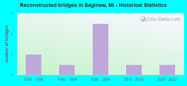
- Reconstructed bridges - Historical Statistics
- 21980-1989
- 11990-1999
- 52000-2009
- 12010-2019
- 12020-2022
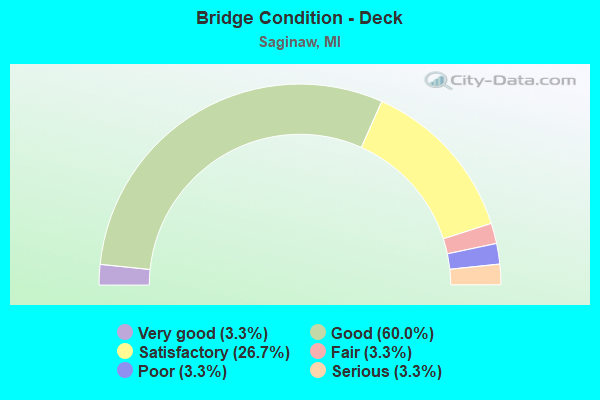
- Bridge Condition - Deck
- 3.3%Very good
- 60.0%Good
- 26.7%Satisfactory
- 3.3%Fair
- 3.3%Poor
- 3.3%Serious
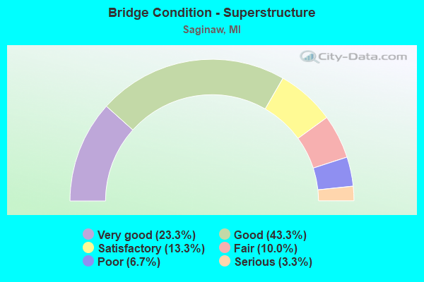
- Bridge Condition - Superstructure
- 23.3%Very good
- 43.3%Good
- 13.3%Satisfactory
- 10.0%Fair
- 6.7%Poor
- 3.3%Serious
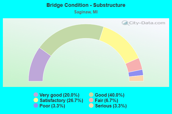
- Bridge Condition - Substructure
- 20.0%Very good
- 40.0%Good
- 26.7%Satisfactory
- 6.7%Fair
- 3.3%Poor
- 3.3%Serious
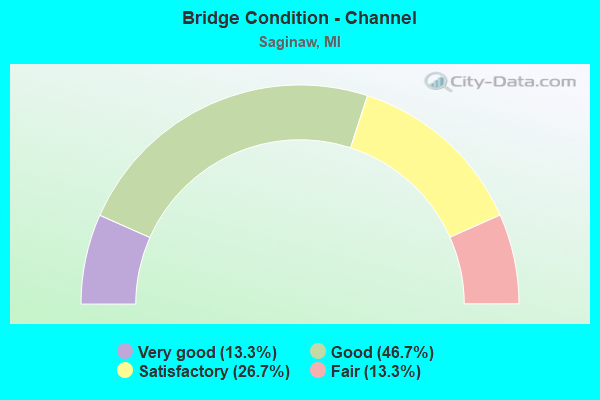
- Bridge Condition - Channel
- 13.3%Very good
- 46.7%Good
- 26.7%Satisfactory
- 13.3%Fair
Find on map >> Show street view
Structure Number: 912, Location: 0.2 MI E OF M-63 (Lat: 42.123300, Lng: -86.463772), Route carried "on" structure: Business Interstate 94, Year Built: 1955, Status: Open, Structure Length: 5.48m (17.98ft), Average Daily Traffic: 7,900 (year 1995), Average Future Daily Traffic: 9,085 (year 2015), Design Load: HS 20, Features Intersected: PAW PAW RIVER
Minimum Vertical Clearance: 30.48m (100.00ft), Kilometerpoint: 1.014, Lanes on structure: 2, Base Highway Network: Yes (Inventory Route: 311, Subroute: 9), Owner: State Highway Agency, Approaching Roadway Width: 16.5m (54.1ft), Skew: 21 degrees, Material/Design: Steel, Design/Construction: Stringer/Multi-beam, Number Of Spans In Main Unit: 3, Length of Maximum Span: 18.2m (59.7ft), Curb or Sidewalk Widths: Left: 0.3m (1.0ft), Right: 0.3m (1.0ft), Curb-To-Curb Width: 17.7m (58.1ft), Out-to-Out Width: 20.2m (66.3ft)
Condition: Deck: Satisfactory, Superstructure: Fair, Substructure: Satisfactory, Channel: Fair, Operating Rating: 93.3 metric tons, Method Used To Determine Operating Rating: Load Factor (LF) rating reported by rating factor (RF) method using MS18 loading, Inventory Rating: 56.1 metric tons, Method Used To Determine Inventory Rating: Load Factor (LF) rating reported by rating factor (RF) method using MS18 loading, Structural Evaluation: Somewhat better than minimum adequacy, Deck Geometry: Superior to present desirable criteria, Waterway Adequacy: Equal to present desirable criteria, Approach Roadway Alignment: Equal to present minimum criteria, Designated Inspection Frequency: Every 24 months, Underwater Inspection Frequency: Every 60 months, Inspection Date: August 2020, Underwater Inspection Date: June 2017, Deck Structure Type: Concrete Cast-file-Place, Wearing Surface/Protective System: Wearing Surface: Monolithic Concrete
Find on map >> Show street view
Structure Number: 913, Location: 1.5 MI E OF BENTON HARBOR (Lat: 42.119250, Lng: -86.407753), Route carried "on" structure: County highway 2013, Year Built: 1968, Status: Open, Structure Length: 5.42m (17.78ft), Average Daily Traffic: 6,200 (year 1992), Truck Traffic: 3%, Average Future Daily Traffic: 2,120 (year 1977), Design Load: H 20, Features Intersected: I-94 BL (MAIN STREET), Facility Carried by Structure: EUCLID AVE
Minimum Vertical Clearance: 30.48m (100.00ft), Kilometerpoint: 1.146, Lanes on structure: 2, Lanes under structure: 4, Owner: State Highway Agency, Approaching Roadway Width: 8.9m (29.2ft), Material/Design: Steel, Design/Construction: Stringer/Multi-beam, Number Of Spans In Main Unit: 2, Length of Maximum Span: 27.1m (88.9ft), Curb or Sidewalk Widths: Left: 1.7m (5.6ft), Right: 0.1m (0.3ft), Curb-To-Curb Width: 8.5m (27.9ft), Out-to-Out Width: 11.1m (36.4ft)
Condition: Deck: Satisfactory, Superstructure: Fair, Substructure: Good, Operating Rating: 64.5 metric tons, Method Used To Determine Operating Rating: Load Factor (LF) rating reported by rating factor (RF) method using MS18 loading, Inventory Rating: 38.6 metric tons, Method Used To Determine Inventory Rating: Load Factor (LF) rating reported by rating factor (RF) method using MS18 loading, Structural Evaluation: Somewhat better than minimum adequacy, Deck Geometry: High priority of replacement, Underclear: High priority of replacement, Approach Roadway Alignment: Equal to present desirable criteria, Length Of Structure Improvement: 5.43m (17.81ft), Designated Inspection Frequency: Every 24 months, Inspection Date: June 2020, Bridge Improvement Cost: $854,000, Roadway Improvement Cost: $6,000, Total Project Cost: $69,000, Deck Structure Type: Concrete Cast-file-Place, Wearing Surface/Protective System: Wearing Surface: Latex Concrete
Find on map >> Show street view
Structure Number: 914, Location: AT CASS CO LINE (Lat: 41.885061, Lng: -86.224092), Route carried "on" structure: State highway 51, Year Built: 2009, Status: Open, Structure Length: 2.56m (8.40ft), Average Daily Traffic: 6,654 (year 2007), Truck Traffic: 6%, Average Future Daily Traffic: 9,400 (year 2028), Design Load: HL 93, Features Intersected: MCKINZIE CREEK
Minimum Vertical Clearance: 30.48m (100.00ft), Kilometerpoint: 7.530, Lanes on structure: 2, Base Highway Network: Yes (Inventory Route: 136, Subroute: 10), Owner: State Highway Agency, Approaching Roadway Width: 13.4m (44.0ft), Material/Design: Prestressed concrete, Design/Construction: Box Beam or Girders - Single/Spread, Number Of Spans In Main Unit: 1, Length of Maximum Span: 24.7m (81.0ft), Curb-To-Curb Width: 13.4m (44.0ft), Out-to-Out Width: 14.4m (47.2ft)
Condition: Deck: Good, Superstructure: Very good, Substructure: Very good, Channel: Fair, Operating Rating: 62.0 metric tons, Method Used To Determine Operating Rating: Load Factor (LF), Inventory Rating: 35.1 metric tons, Method Used To Determine Inventory Rating: Load Factor (LF), Structural Evaluation: Equal to present desirable criteria, Deck Geometry: Equal to present minimum criteria, Waterway Adequacy: Equal to present desirable criteria, Approach Roadway Alignment: Equal to present desirable criteria, Designated Inspection Frequency: Every 24 months, Inspection Date: August 2020, Deck Structure Type: Concrete Cast-file-Place, Wearing Surface/Protective System: Wearing Surface: Monolithic Concrete, Deck Protection: Epoxy Coated Reinforcing
Find on map >> Show street view
Structure Number: 9081, Location: 5.8 MI S OF M-46 (Lat: 43.328625, Lng: -83.953756), Route carried "on" structure: State highway 13, Year Built: 1941, Year Reconstructed: 1986, Status: Open, Structure Length: 1.07m (3.51ft), Average Daily Traffic: 5,700 (year 2015), Truck Traffic: 6%, Average Future Daily Traffic: 6,300 (year 2035), Design Load: HS 20, Features Intersected: MESSNER DRAIN
Minimum Vertical Clearance: 30.48m (100.00ft), Kilometerpoint: 7.089, Lanes on structure: 2, Base Highway Network: Yes (Inventory Route: 47, Subroute: 10), Owner: State Highway Agency, Approaching Roadway Width: 12.8m (42.0ft), Skew: 3 degrees, Material/Design: Steel, Design/Construction: Stringer/Multi-beam, Number Of Spans In Main Unit: 1, Length of Maximum Span: 10.7m (35.1ft), Curb-To-Curb Width: 10.9m (35.8ft), Out-to-Out Width: 11.9m (39.0ft)
Condition: Deck: Good, Superstructure: Very good, Substructure: Good, Channel: Very good, Operating Rating: 72.9 metric tons, Method Used To Determine Operating Rating: Load Factor (LF) rating reported by rating factor (RF) method using MS18 loading, Inventory Rating: 49.6 metric tons, Method Used To Determine Inventory Rating: Load Factor (LF) rating reported by rating factor (RF) method using MS18 loading, Structural Evaluation: Better than present minimum criteria, Deck Geometry: Meets minimum limits, Waterway Adequacy: Somewhat better than minimum adequacy, Approach Roadway Alignment: Equal to present minimum criteria, Designated Inspection Frequency: Every 24 months, Inspection Date: July 2021, Deck Structure Type: Concrete Cast-file-Place, Wearing Surface/Protective System: Wearing Surface: Epoxy Overlay, Deck Protection: Epoxy Coated Reinforcing
Find on map >> Show street view
Structure Number: 9082, Location: 3.3 MI S OF M-46 (Lat: 43.364500, Lng: -83.954850), Route carried "on" structure: State highway 13, Year Built: 1964, Status: Open, Structure Length: 11.89m (39.01ft), Average Daily Traffic: 5,700 (year 2015), Truck Traffic: 6%, Average Future Daily Traffic: 6,300 (year 2035), Design Load: HS 20, Features Intersected: CASS RIVER
Minimum Vertical Clearance: 30.48m (100.00ft), Kilometerpoint: 10.863, Lanes on structure: 2, Base Highway Network: Yes (Inventory Route: 47, Subroute: 10), Owner: State Highway Agency, Approaching Roadway Width: 12.8m (42.0ft), Material/Design: Steel, Design/Construction: Stringer/Multi-beam, Number Of Spans In Main Unit: 6, Length of Maximum Span: 19.6m (64.3ft), Curb-To-Curb Width: 9.1m (29.9ft), Out-to-Out Width: 11.4m (37.4ft)
Condition: Deck: Satisfactory, Superstructure: Satisfactory, Substructure: Fair, Channel: Satisfactory, Operating Rating: 97.2 metric tons, Method Used To Determine Operating Rating: Load Factor (LF) rating reported by rating factor (RF) method using MS18 loading, Inventory Rating: 64.2 metric tons, Method Used To Determine Inventory Rating: Load Factor (LF) rating reported by rating factor (RF) method using MS18 loading, Structural Evaluation: Somewhat better than minimum adequacy, Deck Geometry: Meets minimum limits, Waterway Adequacy: Somewhat better than minimum adequacy, Approach Roadway Alignment: Somewhat better than minimum adequacy, Designated Inspection Frequency: Every 24 months, Inspection Date: July 2021, Deck Structure Type: Concrete Cast-file-Place, Wearing Surface/Protective System: Wearing Surface: Epoxy Overlay
Find on map >> Show street view
Structure Number: 9083, Location: 1.8 MI S OF M-46 (Lat: 43.384922, Lng: -83.955389), Route carried "on" structure: State highway 13, Year Built: 2010, Status: Open, Structure Length: 1.05m (3.44ft), Average Daily Traffic: 7,000 (year 2010), Truck Traffic: 7%, Average Future Daily Traffic: 7,700 (year 2030), Design Load: HL 93, Features Intersected: KING DRAIN
Minimum Vertical Clearance: 30.48m (100.00ft), Kilometerpoint: 13.055, Lanes on structure: 2, Base Highway Network: Yes (Inventory Route: 47, Subroute: 10), Owner: State Highway Agency, Approaching Roadway Width: 13.4m (44.0ft), Skew: 2 degrees, Material/Design: Concrete, Design/Construction: Culvert, Number Of Spans In Main Unit: 1, Length of Maximum Span: 9.5m (31.2ft), Curb-To-Curb Width: 13.4m (44.0ft), Out-to-Out Width: 14.9m (48.9ft)
Condition: Channel: Very good, Culverts: Very good, Operating Rating: 46.0 metric tons, Method Used To Determine Operating Rating: Load and Resistance Factor Rating (LRFR) rating reported by rating factor(RF) method using HL-93 loadings, Inventory Rating: 35.6 metric tons, Method Used To Determine Inventory Rating: Load and Resistance Factor Rating (LRFR) rating reported by rating factor(RF) method using HL-93 loadings, Structural Evaluation: Equal to present desirable criteria, Deck Geometry: Equal to present minimum criteria, Waterway Adequacy: Equal to present minimum criteria, Approach Roadway Alignment: Equal to present minimum criteria, Designated Inspection Frequency: Every 24 months, Inspection Date: October 2021, Deck Structure Type: Concrete Precast Panels, Wearing Surface/Protective System: Wearing Surface: Bituminous
Find on map >> Show street view
Structure Number: 9096, Location: IN SAGINAW (Lat: 43.410358, Lng: -83.964336), Route carried "on" structure: State highway 46, Year Built: 1957, Year Reconstructed: 1997, Status: Open, Structure Length: 19.20m (62.99ft), Average Daily Traffic: 17,266 (year 2007), Truck Traffic: 7%, Average Future Daily Traffic: 16,638 (year 2018), Design Load: HS 20, Features Intersected: SAGINAW RIVER
Minimum Vertical Clearance: 30.48m (100.00ft), Kilometerpoint: 1.450, Lanes on structure: 4, Base Highway Network: Yes (Inventory Route: 46, Subroute: 5), Owner: State Highway Agency, Approaching Roadway Width: 13.4m (44.0ft), Skew: 20 degrees, Navigation Control: Yes ( Vertical Clearance: 0.3m (1.0ft), Horizontal Clearance: 20.1m (65.9ft)), Material/Design: Prestressed concrete, Design/Construction: Stringer/Multi-beam, Number Of Spans In Main Unit: 9, Length of Maximum Span: 21.6m (70.9ft), Curb or Sidewalk Widths: Left: 1.5m (4.9ft), Right: 1.5m (4.9ft), Curb-To-Curb Width: 13.4m (44.0ft), Out-to-Out Width: 21.0m (68.9ft)
Condition: Deck: Good, Superstructure: Satisfactory, Substructure: Satisfactory, Channel: Satisfactory, Operating Rating: 63.8 metric tons, Method Used To Determine Operating Rating: Load Factor (LF) rating reported by rating factor (RF) method using MS18 loading, Inventory Rating: 37.9 metric tons, Method Used To Determine Inventory Rating: Load Factor (LF) rating reported by rating factor (RF) method using MS18 loading, Structural Evaluation: Equal to present minimum criteria, Deck Geometry: High priority of replacement, Waterway Adequacy: Better than present minimum criteria, Approach Roadway Alignment: Equal to present minimum criteria, Designated Inspection Frequency: Every 24 months, Underwater Inspection Frequency: Every 60 months, Inspection Date: August 2021, Underwater Inspection Date: August 2020, Deck Structure Type: Concrete Cast-file-Place, Wearing Surface/Protective System: Wearing Surface: Monolithic Concrete, Deck Protection: Epoxy Coated Reinforcing
Find on map >> Show street view
Structure Number: 9115, Location: IN SAGINAW (Lat: 43.437100, Lng: -83.937694), Route carried "on" structure: Interstate 675, Year Built: 1971, Year Reconstructed: 2009, Status: Open, Structure Length: 89.87m (294.85ft), Average Daily Traffic: 32,200 (year 2007), Truck Traffic: 3%, Average Future Daily Traffic: 34,762 (year 2018), Design Load: HS 20+Mod, Features Intersected: SAG RIV, H&E,SBS RR, M13
Minimum Vertical Clearance: 30.48m (100.00ft), Kilometerpoint: 3.879, Lanes on structure: 4, Lanes under structure: 12, Base Highway Network: Yes (Inventory Route: 46, Subroute: 2), Owner: State Highway Agency, Approaching Roadway Width: 27.7m (90.9ft), Skew: 39 degrees, Navigation Control: Yes ( Vertical Clearance: 0.3m (1.0ft), Horizontal Clearance: 42.0m (137.8ft)), Material/Design: Steel continuous, Design/Construction: Stringer/Multi-beam, Number Of Spans In Main Unit: 3, Number Of Approach Spans: 39, Length of Maximum Span: 43.2m (141.7ft), Curb-To-Curb Width: 26.4m (86.6ft), Out-to-Out Width: 28.7m (94.2ft)
Condition: Deck: Good, Superstructure: Fair, Substructure: Satisfactory, Channel: Good, Operating Rating: 62.2 metric tons, Method Used To Determine Operating Rating: Load Factor (LF) rating reported by rating factor (RF) method using MS18 loading, Inventory Rating: 37.3 metric tons, Method Used To Determine Inventory Rating: Load Factor (LF) rating reported by rating factor (RF) method using MS18 loading, Structural Evaluation: Somewhat better than minimum adequacy, Deck Geometry: Superior to present desirable criteria, Underclear: Meets minimum limits, Waterway Adequacy: Equal to present desirable criteria, Approach Roadway Alignment: Equal to present desirable criteria, Designated Inspection Frequency: Every 24 months, Underwater Inspection Frequency: Every 60 months, Inspection Date: May 2021, Underwater Inspection Date: September 2020, Deck Structure Type: Concrete Cast-file-Place, Wearing Surface/Protective System: Wearing Surface: Latex Concrete, Deck Protection: Epoxy Coated Reinforcing
Find on map >> Show street view
Structure Number: 9116, Location: IN SAGINAW (Lat: 43.437350, Lng: -83.947525), Route carried "on" structure: Ramp Interstate 675, Year Built: 1971, Year Reconstructed: 2009, Status: Open, Structure Length: 19.60m (64.30ft), Average Daily Traffic: 14,143 (year 2017), Truck Traffic: 7%, Average Future Daily Traffic: 16,264 (year 2037), Design Load: HS 20+Mod, Features Intersected: H&E RR, DAVENPORT
Minimum Vertical Clearance: 30.48m (100.00ft), Kilometerpoint: 0.209, Lanes on structure: 1, Lanes under structure: 3, Owner: State Highway Agency, Approaching Roadway Width: 10.9m (35.8ft), Skew: 9 degrees, Material/Design: Steel, Design/Construction: Stringer/Multi-beam, Number Of Spans In Main Unit: 10, Length of Maximum Span: 24.4m (80.1ft), Curb-To-Curb Width: 7.5m (24.6ft), Out-to-Out Width: 8.2m (26.9ft)
Condition: Deck: Good, Superstructure: Good, Substructure: Good, Operating Rating: 59.0 metric tons, Method Used To Determine Operating Rating: Load Factor (LF) rating reported by rating factor (RF) method using MS18 loading, Inventory Rating: 35.3 metric tons, Method Used To Determine Inventory Rating: Load Factor (LF) rating reported by rating factor (RF) method using MS18 loading, Structural Evaluation: Better than present minimum criteria, Deck Geometry: Better than present minimum criteria, Underclear: Equal to present minimum criteria, Approach Roadway Alignment: Equal to present desirable criteria, Designated Inspection Frequency: Every 24 months, Inspection Date: May 2021, Deck Structure Type: Concrete Cast-file-Place, Wearing Surface/Protective System: Wearing Surface: Epoxy Overlay, Deck Protection: Epoxy Coated Reinforcing
Find on map >> Show street view
Structure Number: 9127, Location: IN SAGINAW (Lat: 43.434078, Lng: -83.912558), Route carried "on" structure: City street 2004, Year Built: 1971, Year Reconstructed: 2010, Status: Open, Structure Length: 6.22m (20.41ft), Truck Traffic: 2%, Average Future Daily Traffic: 6,158 (year 2041), Design Load: H 20, Features Intersected: I-675, Facility Carried by Structure: NB VETERAN MEM PWY
Minimum Vertical Clearance: 30.48m (100.00ft), Kilometerpoint: 0.259, Lanes on structure: 3, Lanes under structure: 6, Owner: State Highway Agency, Approaching Roadway Width: 12.2m (40.0ft), Skew: 12 degrees, Material/Design: Steel continuous, Design/Construction: Stringer/Multi-beam, Number Of Spans In Main Unit: 2, Length of Maximum Span: 31.1m (102.0ft), Curb or Sidewalk Widths: Left: 1.8m (5.9ft), Right: 1.8m (5.9ft), Curb-To-Curb Width: 12.2m (40.0ft), Out-to-Out Width: 16.6m (54.5ft)
Condition: Deck: Good, Superstructure: Very good, Substructure: Satisfactory, Operating Rating: 61.5 metric tons, Method Used To Determine Operating Rating: Load Factor (LF), Inventory Rating: 36.9 metric tons, Method Used To Determine Inventory Rating: Load Factor (LF), Structural Evaluation: Equal to present minimum criteria, Deck Geometry: Meets minimum limits, Underclear: Meets minimum limits, Approach Roadway Alignment: Equal to present desirable criteria, Designated Inspection Frequency: Every 24 months, Inspection Date: October 2020, Deck Structure Type: Concrete Cast-file-Place, Wearing Surface/Protective System: Wearing Surface: Epoxy Overlay, Deck Protection: Epoxy Coated Reinforcing
Find on map >> Show street view
Structure Number: 9128, Location: IN SAGINAW (Lat: 43.434153, Lng: -83.912886), Route carried "on" structure: City street 2004, Year Built: 1971, Status: Open, Structure Length: 6.22m (20.41ft), Truck Traffic: 2%, Average Future Daily Traffic: 6,188 (year 2041), Design Load: H 20, Features Intersected: I-675, Facility Carried by Structure: SB VETERAN MEM PWY
Minimum Vertical Clearance: 30.48m (100.00ft), Kilometerpoint: 0.235, Lanes on structure: 3, Lanes under structure: 6, Owner: State Highway Agency, Approaching Roadway Width: 18.2m (59.7ft), Skew: 12 degrees, Material/Design: Steel continuous, Design/Construction: Stringer/Multi-beam, Number Of Spans In Main Unit: 2, Length of Maximum Span: 31.1m (102.0ft), Curb or Sidewalk Widths: Left: 1.5m (4.9ft), Right: 0.2m (0.7ft), Curb-To-Curb Width: 12.2m (40.0ft), Out-to-Out Width: 14.7m (48.2ft)
Condition: Deck: Poor, Superstructure: Poor, Substructure: Satisfactory, Operating Rating: 88.1 metric tons, Method Used To Determine Operating Rating: Load Factor (LF) rating reported by rating factor (RF) method using MS18 loading, Inventory Rating: 52.8 metric tons, Method Used To Determine Inventory Rating: Load Factor (LF) rating reported by rating factor (RF) method using MS18 loading, Structural Evaluation: Meets minimum limits, Deck Geometry: Meets minimum limits, Underclear: High priority of corrective action, Approach Roadway Alignment: Equal to present desirable criteria, Designated Inspection Frequency: Every 12 months, Inspection Date: October 2021, Deck Structure Type: Concrete Cast-file-Place, Wearing Surface/Protective System: Wearing Surface: Bituminous
Find on map >> Show street view
Structure Number: 9129, Location: IN SAGINAW (Lat: 43.434242, Lng: -83.917594), Route carried "on" structure: City street , Year Built: 1971, Year Reconstructed: 2009, Status: Open, Structure Length: 5.55m (18.21ft), Average Daily Traffic: 2,650 (year 1990), Truck Traffic: 2%, Average Future Daily Traffic: 2,800 (year 2010), Design Load: H 15, Features Intersected: I-675, Facility Carried by Structure: 14TH ST
Minimum Vertical Clearance: 30.48m (100.00ft), Kilometerpoint: 1.365, Lanes on structure: 2, Lanes under structure: 6, Owner: State Highway Agency, Approaching Roadway Width: 10.3m (33.8ft), Material/Design: Steel continuous, Design/Construction: Stringer/Multi-beam, Number Of Spans In Main Unit: 2, Length of Maximum Span: 27.7m (90.9ft), Curb or Sidewalk Widths: Left: 2.4m (7.9ft), Right: 2.4m (7.9ft), Curb-To-Curb Width: 9.1m (29.9ft), Out-to-Out Width: 14.8m (48.6ft)
Condition: Deck: Good, Superstructure: Good, Substructure: Satisfactory, Inventory Rating: 62.1 metric tons, Method Used To Determine Inventory Rating: Load Factor (LF), Structural Evaluation: Equal to present minimum criteria, Deck Geometry: Meets minimum limits, Underclear: Meets minimum limits, Approach Roadway Alignment: Equal to present desirable criteria, Designated Inspection Frequency: Every 24 months, Inspection Date: November 2020, Deck Structure Type: Concrete Cast-file-Place, Wearing Surface/Protective System: Wearing Surface: Latex Concrete, Deck Protection: Epoxy Coated Reinforcing
Find on map >> Show street view
Structure Number: 913, Location: IN SAGINAW (Lat: 43.436067, Lng: -83.926614), Route carried "on" structure: Interstate 675, Year Built: 2011, Status: Open, Structure Length: 2.05m (6.73ft), Average Daily Traffic: 13,527 (year 2007), Truck Traffic: 4%, Average Future Daily Traffic: 13,840 (year 2018), Design Load: HL 93, Features Intersected: 6TH ST
Minimum Vertical Clearance: 30.48m (100.00ft), Kilometerpoint: 2.968, Lanes on structure: 3, Lanes under structure: 2, Base Highway Network: Yes (Inventory Route: 46, Subroute: 2), Owner: State Highway Agency, Approaching Roadway Width: 12.8m (42.0ft), Skew: 11 degrees, Material/Design: Prestressed concrete, Design/Construction: Box Beam or Girders - Single/Spread, Number Of Spans In Main Unit: 1, Length of Maximum Span: 19.9m (65.3ft), Curb-To-Curb Width: 16.3m (53.5ft), Out-to-Out Width: 17.2m (56.4ft)
Condition: Deck: Good, Superstructure: Very good, Substructure: Very good, Operating Rating: 58.0 metric tons, Method Used To Determine Operating Rating: Load and Resistance Factor Rating (LRFR) rating reported by rating factor(RF) method using HL-93 loadings, Inventory Rating: 36.9 metric tons, Method Used To Determine Inventory Rating: Load and Resistance Factor Rating (LRFR) rating reported by rating factor(RF) method using HL-93 loadings, Structural Evaluation: Equal to present desirable criteria, Deck Geometry: Equal to present minimum criteria, Underclear: Somewhat better than minimum adequacy, Approach Roadway Alignment: Equal to present desirable criteria, Designated Inspection Frequency: Every 24 months, Inspection Date: October 2020, Deck Structure Type: Concrete Cast-file-Place, Wearing Surface/Protective System: Wearing Surface: Monolithic Concrete, Deck Protection: Epoxy Coated Reinforcing
Find on map >> Show street view
Structure Number: 9131, Location: IN SAGINAW (Lat: 43.435878, Lng: -83.926542), Route carried "on" structure: Interstate 675, Year Built: 2011, Status: Open, Structure Length: 2.06m (6.76ft), Average Daily Traffic: 11,654 (year 2017), Truck Traffic: 8%, Average Future Daily Traffic: 13,402 (year 2037), Design Load: HL 93, Features Intersected: 6TH ST
Minimum Vertical Clearance: 30.48m (100.00ft), Kilometerpoint: 3.201, Lanes on structure: 2, Lanes under structure: 4, Base Highway Network: Yes (Inventory Route: 46, Subroute: 1), Owner: State Highway Agency, Approaching Roadway Width: 15.2m (49.9ft), Skew: 11 degrees, Material/Design: Prestressed concrete, Design/Construction: Box Beam or Girders - Single/Spread, Number Of Spans In Main Unit: 1, Length of Maximum Span: 19.7m (64.6ft), Curb-To-Curb Width: 17.5m (57.4ft), Out-to-Out Width: 18.3m (60.0ft)
Condition: Deck: Good, Superstructure: Very good, Substructure: Very good, Operating Rating: 57.7 metric tons, Method Used To Determine Operating Rating: Load and Resistance Factor Rating (LRFR) rating reported by rating factor(RF) method using HL-93 loadings, Inventory Rating: 37.6 metric tons, Method Used To Determine Inventory Rating: Load and Resistance Factor Rating (LRFR) rating reported by rating factor(RF) method using HL-93 loadings, Structural Evaluation: Equal to present desirable criteria, Deck Geometry: Superior to present desirable criteria, Underclear: Equal to present minimum criteria, Approach Roadway Alignment: Equal to present desirable criteria, Designated Inspection Frequency: Every 24 months, Inspection Date: October 2020, Deck Structure Type: Concrete Cast-file-Place, Wearing Surface/Protective System: Wearing Surface: Epoxy Overlay, Deck Protection: Epoxy Coated Reinforcing
Find on map >> Show street view
Structure Number: 9132, Location: IN SAGINAW (Lat: 43.436064, Lng: -83.927675), Route carried "on" structure: Interstate 675, Year Built: 2011, Status: Open, Structure Length: 1.83m (6.00ft), Average Daily Traffic: 13,527 (year 2007), Truck Traffic: 4%, Average Future Daily Traffic: 13,244 (year 2018), Design Load: HL 93, Features Intersected: 5TH ST
Minimum Vertical Clearance: 30.48m (100.00ft), Kilometerpoint: 3.055, Lanes on structure: 3, Lanes under structure: 2, Base Highway Network: Yes (Inventory Route: 46, Subroute: 2), Owner: State Highway Agency, Approaching Roadway Width: 15.5m (50.9ft), Skew: 10 degrees, Material/Design: Prestressed concrete, Design/Construction: Box Beam or Girders - Single/Spread, Number Of Spans In Main Unit: 1, Length of Maximum Span: 17.4m (57.1ft), Curb-To-Curb Width: 13.7m (44.9ft), Out-to-Out Width: 20.6m (67.6ft)
Condition: Deck: Good, Superstructure: Good, Substructure: Very good, Operating Rating: 57.3 metric tons, Method Used To Determine Operating Rating: Load and Resistance Factor Rating (LRFR) rating reported by rating factor(RF) method using HL-93 loadings, Inventory Rating: 36.3 metric tons, Method Used To Determine Inventory Rating: Load and Resistance Factor Rating (LRFR) rating reported by rating factor(RF) method using HL-93 loadings, Structural Evaluation: Better than present minimum criteria, Deck Geometry: High priority of corrective action, Underclear: Meets minimum limits, Approach Roadway Alignment: Equal to present desirable criteria, Designated Inspection Frequency: Every 24 months, Inspection Date: October 2020, Deck Structure Type: Concrete Cast-file-Place, Wearing Surface/Protective System: Wearing Surface: Monolithic Concrete, Deck Protection: Epoxy Coated Reinforcing
Find on map >> Show street view
Structure Number: 9133, Location: IN SAGINAW (Lat: 43.435878, Lng: -83.927686), Route carried "on" structure: Interstate 675, Year Built: 2011, Status: Open, Structure Length: 1.83m (6.00ft), Average Daily Traffic: 11,654 (year 2017), Truck Traffic: 8%, Average Future Daily Traffic: 13,402 (year 2037), Design Load: HL 93, Features Intersected: 5TH ST
Minimum Vertical Clearance: 30.48m (100.00ft), Kilometerpoint: 3.293, Lanes on structure: 3, Lanes under structure: 2, Base Highway Network: Yes (Inventory Route: 46, Subroute: 1), Owner: State Highway Agency, Approaching Roadway Width: 16.5m (54.1ft), Skew: 10 degrees, Material/Design: Prestressed concrete, Design/Construction: Stringer/Multi-beam, Number Of Spans In Main Unit: 1, Length of Maximum Span: 17.4m (57.1ft), Curb-To-Curb Width: 19.6m (64.3ft), Out-to-Out Width: 20.1m (65.9ft)
Condition: Deck: Good, Superstructure: Very good, Substructure: Very good, Operating Rating: 59.3 metric tons, Method Used To Determine Operating Rating: Load and Resistance Factor Rating (LRFR) rating reported by rating factor(RF) method using HL-93 loadings, Inventory Rating: 38.2 metric tons, Method Used To Determine Inventory Rating: Load and Resistance Factor Rating (LRFR) rating reported by rating factor(RF) method using HL-93 loadings, Structural Evaluation: Equal to present desirable criteria, Deck Geometry: Superior to present desirable criteria, Underclear: Meets minimum limits, Approach Roadway Alignment: Equal to present desirable criteria, Designated Inspection Frequency: Every 24 months, Inspection Date: October 2020, Deck Structure Type: Concrete Cast-file-Place, Wearing Surface/Protective System: Wearing Surface: Epoxy Overlay
Find on map >> Show street view
Structure Number: 9136, Location: IN SAGINAW (Lat: 43.436250, Lng: -83.933161), Route carried "on" structure: Interstate 675, Year Built: 2011, Status: Open, Structure Length: 2.53m (8.30ft), Average Daily Traffic: 10,646 (year 2017), Truck Traffic: 8%, Average Future Daily Traffic: 12,242 (year 2037), Design Load: HL 93, Features Intersected: WARREN AVENUE
Minimum Vertical Clearance: 30.48m (100.00ft), Kilometerpoint: 3.499, Lanes on structure: 2, Lanes under structure: 3, Base Highway Network: Yes (Inventory Route: 46, Subroute: 2), Owner: State Highway Agency, Approaching Roadway Width: 12.8m (42.0ft), Material/Design: Prestressed concrete, Design/Construction: Box Beam or Girders - Single/Spread, Number Of Spans In Main Unit: 1, Length of Maximum Span: 24.4m (80.1ft), Curb-To-Curb Width: 13.4m (44.0ft), Out-to-Out Width: 14.4m (47.2ft)
Condition: Deck: Good, Superstructure: Good, Substructure: Good, Operating Rating: 53.8 metric tons, Method Used To Determine Operating Rating: Load and Resistance Factor Rating (LRFR) rating reported by rating factor(RF) method using HL-93 loadings, Inventory Rating: 37.9 metric tons, Method Used To Determine Inventory Rating: Load and Resistance Factor Rating (LRFR) rating reported by rating factor(RF) method using HL-93 loadings, Structural Evaluation: Better than present minimum criteria, Deck Geometry: Superior to present desirable criteria, Underclear: Equal to present minimum criteria, Approach Roadway Alignment: Equal to present desirable criteria, Designated Inspection Frequency: Every 24 months, Inspection Date: October 2020, Deck Structure Type: Concrete Cast-file-Place, Wearing Surface/Protective System: Wearing Surface: Epoxy Overlay, Deck Protection: Epoxy Coated Reinforcing
Find on map >> Show street view
Structure Number: 9137, Location: IN SAGINAW (Lat: 43.440642, Lng: -83.949472), Route carried "on" structure: Interstate 675, Year Built: 1971, Year Reconstructed: 2009, Status: Open, Structure Length: 6.00m (19.69ft), Average Daily Traffic: 13,177 (year 2007), Truck Traffic: 4%, Average Future Daily Traffic: 17,064 (year 2018), Design Load: HS 20+Mod, Features Intersected: MICHIGAN AVE
Minimum Vertical Clearance: 30.48m (100.00ft), Kilometerpoint: 4.938, Lanes on structure: 2, Lanes under structure: 3, Base Highway Network: Yes (Inventory Route: 46, Subroute: 2), Owner: State Highway Agency, Approaching Roadway Width: 12.8m (42.0ft), Skew: 15 degrees, Material/Design: Steel, Design/Construction: Stringer/Multi-beam, Number Of Spans In Main Unit: 3, Length of Maximum Span: 27.5m (90.2ft), Curb-To-Curb Width: 13.2m (43.3ft), Out-to-Out Width: 14.0m (45.9ft)
Condition: Deck: Satisfactory, Superstructure: Good, Substructure: Satisfactory, Operating Rating: 68.4 metric tons, Method Used To Determine Operating Rating: Load Factor (LF), Inventory Rating: 41.0 metric tons, Method Used To Determine Inventory Rating: Load Factor (LF), Structural Evaluation: Equal to present minimum criteria, Deck Geometry: Superior to present desirable criteria, Underclear: Somewhat better than minimum adequacy, Approach Roadway Alignment: Equal to present desirable criteria, Designated Inspection Frequency: Every 24 months, Inspection Date: November 2020, Deck Structure Type: Concrete Cast-file-Place, Wearing Surface/Protective System: Wearing Surface: Monolithic Concrete, Deck Protection: Epoxy Coated Reinforcing
Find on map >> Show street view
Structure Number: 9138, Location: IN SAGINAW (Lat: 43.440367, Lng: -83.949536), Route carried "on" structure: Interstate 675, Year Built: 1971, Status: Open, Structure Length: 6.00m (19.69ft), Average Daily Traffic: 13,032 (year 2017), Truck Traffic: 6%, Average Future Daily Traffic: 14,987 (year 2037), Design Load: HS 20+Mod, Features Intersected: MICHIGAN AVE
Minimum Vertical Clearance: 30.48m (100.00ft), Kilometerpoint: 5.169, Lanes on structure: 2, Lanes under structure: 3, Base Highway Network: Yes (Inventory Route: 46, Subroute: 1), Owner: State Highway Agency, Approaching Roadway Width: 13.1m (43.0ft), Skew: 14 degrees, Material/Design: Steel, Design/Construction: Stringer/Multi-beam, Number Of Spans In Main Unit: 3, Length of Maximum Span: 27.4m (89.9ft), Curb-To-Curb Width: 12.1m (39.7ft), Out-to-Out Width: 13.1m (43.0ft)
Condition: Deck: Satisfactory, Superstructure: Good, Substructure: Good, Operating Rating: 61.1 metric tons, Method Used To Determine Operating Rating: Load Factor (LF), Inventory Rating: 36.7 metric tons, Method Used To Determine Inventory Rating: Load Factor (LF), Structural Evaluation: Better than present minimum criteria, Deck Geometry: Equal to present minimum criteria, Underclear: High priority of corrective action, Approach Roadway Alignment: Equal to present desirable criteria, Designated Inspection Frequency: Every 24 months, Inspection Date: November 2020, Deck Structure Type: Concrete Cast-file-Place, Wearing Surface/Protective System: Wearing Surface: Epoxy Overlay
Find on map >> Show street view
Structure Number: 9139, Location: IN SAGINAW, AT N CTY LMTS (Lat: 43.443675, Lng: -83.950531), Route carried "on" structure: Interstate 675, Year Built: 1971, Year Reconstructed: 2009, Status: Open, Structure Length: 4.06m (13.32ft), Average Daily Traffic: 13,177 (year 2007), Truck Traffic: 4%, Average Future Daily Traffic: 22,270 (year 2027), Design Load: HS 20+Mod, Features Intersected: WEISS ST
Minimum Vertical Clearance: 30.48m (100.00ft), Kilometerpoint: 5.288, Lanes on structure: 3, Lanes under structure: 3, Base Highway Network: Yes (Inventory Route: 46, Subroute: 2), Owner: State Highway Agency, Approaching Roadway Width: 16.1m (52.8ft), Skew: 10 degrees, Material/Design: Steel, Design/Construction: Stringer/Multi-beam, Number Of Spans In Main Unit: 3, Length of Maximum Span: 21.8m (71.5ft), Curb-To-Curb Width: 16.8m (55.1ft), Out-to-Out Width: 17.6m (57.7ft)
Condition: Deck: Good, Superstructure: Good, Substructure: Good, Operating Rating: 66.1 metric tons, Method Used To Determine Operating Rating: Load Factor (LF), Inventory Rating: 39.6 metric tons, Method Used To Determine Inventory Rating: Load Factor (LF), Structural Evaluation: Better than present minimum criteria, Deck Geometry: Equal to present minimum criteria, Underclear: Equal to present minimum criteria, Approach Roadway Alignment: Equal to present desirable criteria, Designated Inspection Frequency: Every 24 months, Inspection Date: October 2020, Deck Structure Type: Concrete Cast-file-Place, Wearing Surface/Protective System: Wearing Surface: Latex Concrete, Deck Protection: Epoxy Coated Reinforcing
Find on map >> Show street view
Structure Number: 914, Location: IN SAGINAW, AT N CTY LMTS (Lat: 43.443683, Lng: -83.950822), Route carried "on" structure: Interstate 675, Year Built: 1971, Status: Open, Structure Length: 4.06m (13.32ft), Average Daily Traffic: 13,032 (year 2017), Truck Traffic: 6%, Average Future Daily Traffic: 14,987 (year 2037), Design Load: HS 20+Mod, Features Intersected: WEISS ST
Minimum Vertical Clearance: 30.48m (100.00ft), Kilometerpoint: 5.557, Lanes on structure: 3, Lanes under structure: 3, Base Highway Network: Yes (Inventory Route: 46, Subroute: 1), Owner: State Highway Agency, Approaching Roadway Width: 14.3m (46.9ft), Skew: 10 degrees, Material/Design: Steel, Design/Construction: Stringer/Multi-beam, Number Of Spans In Main Unit: 3, Length of Maximum Span: 21.9m (71.9ft), Curb-To-Curb Width: 14.6m (47.9ft), Out-to-Out Width: 15.3m (50.2ft)
Condition: Deck: Fair, Superstructure: Good, Substructure: Good, Operating Rating: 59.9 metric tons, Method Used To Determine Operating Rating: Load Factor (LF), Inventory Rating: 35.9 metric tons, Method Used To Determine Inventory Rating: Load Factor (LF), Structural Evaluation: Better than present minimum criteria, Deck Geometry: Meets minimum limits, Underclear: High priority of corrective action, Approach Roadway Alignment: Equal to present desirable criteria, Designated Inspection Frequency: Every 24 months, Inspection Date: October 2020, Deck Structure Type: Concrete Cast-file-Place, Wearing Surface/Protective System: Wearing Surface: Epoxy Overlay
Find on map >> Show street view
Structure Number: 9409, Location: 0.4 MI N OF CURTIS ROAD (Lat: 43.327608, Lng: -83.968586), Route carried "on" structure: ServiceCounty highway , Year Built: 1920, Status: Posted for load, Structure Length: 4.11m (13.48ft), Average Daily Traffic: 116 (year 2007), Truck Traffic: 5%, Average Future Daily Traffic: 122 (year 2017), Design Load: H 15, Features Intersected: COLE DRAIN, Facility Carried by Structure: MOWER ROAD
Minimum Vertical Clearance: 30.48m (100.00ft), Kilometerpoint: 0.631, Lanes on structure: 2, Owner: County Highway Agency, Approaching Roadway Width: 8.2m (26.9ft), Material/Design: Concrete, Design/Construction: Slab, Number Of Spans In Main Unit: 3, Length of Maximum Span: 13.7m (44.9ft), Curb-To-Curb Width: 5.5m (18.0ft), Out-to-Out Width: 6.4m (21.0ft)
Condition: Deck: Serious, Superstructure: Serious, Substructure: Serious, Channel: Satisfactory, Operating Rating: 18.0 metric tons, Method Used To Determine Operating Rating: Field evaluation and documented engineering judgment, Inventory Rating: 10.7 metric tons, Method Used To Determine Inventory Rating: Field evaluation and documented engineering judgment, Structural Evaluation: High priority of replacement, Deck Geometry: High priority of corrective action, Waterway Adequacy: Equal to present desirable criteria, Approach Roadway Alignment: Equal to present desirable criteria, Bridge Posting: Required (Relationship of Operating Rating to Maximum Legal Load: > 39.9% below), Length Of Structure Improvement: 6.10m (20.01ft), Designated Inspection Frequency: Every 12 months, Inspection Date: May 2021, Bridge Improvement Cost: $725,000, Roadway Improvement Cost: $75,000, Total Project Cost: $800,000, Deck Structure Type: Concrete Cast-file-Place, Wearing Surface/Protective System: Wearing Surface: Bituminous
Find on map >> Show street view
Structure Number: 9435, Location: CITY OF SAGINAW (Lat: 43.415253, Lng: -83.961186), Route carried "on" structure: City street 2004, Year Built: 1940, Year Reconstructed: 1992, Status: Open, Structure Length: 26.40m (86.61ft), Average Daily Traffic: 10,950 (year 2015), Truck Traffic: 5%, Average Future Daily Traffic: 16,272 (year 2035), Design Load: HS 20+Mod, Features Intersected: SAGINAW RIVER,PRK ACCESS, Facility Carried by Structure: COURT STREET
Minimum Vertical Clearance: 30.48m (100.00ft), Kilometerpoint: 3.150, Lanes on structure: 4, Lanes under structure: 2, Base Highway Network: Yes (Inventory Route: 45, Subroute: 8), Owner: City or Municipal Highway Agency, Approaching Roadway Width: 16.4m (53.8ft), Navigation Control: Yes ( Vertical Clearance: 9.7m (31.8ft), Horizontal Clearance: 21.5m (70.5ft)), Material/Design: Steel, Design/Construction: Stringer/Multi-beam, Number Of Spans In Main Unit: 5, Number Of Approach Spans: 9, Length of Maximum Span: 36.5m (119.8ft), Curb or Sidewalk Widths: Left: 2.4m (7.9ft), Right: 2.4m (7.9ft), Curb-To-Curb Width: 15.8m (51.8ft), Out-to-Out Width: 21.6m (70.9ft)
Condition: Deck: Good, Superstructure: Good, Substructure: Fair, Channel: Good, Operating Rating: 63.2 metric tons, Method Used To Determine Operating Rating: Load Factor (LF), Inventory Rating: 37.8 metric tons, Method Used To Determine Inventory Rating: Load Factor (LF), Structural Evaluation: Somewhat better than minimum adequacy, Deck Geometry: Meets minimum limits, Underclear: Better than present minimum criteria, Waterway Adequacy: Superior to present desirable criteria, Approach Roadway Alignment: Equal to present desirable criteria, Length Of Structure Improvement: 26.40m (86.61ft), Designated Inspection Frequency: Every 24 months, Underwater Inspection Frequency: Every 60 months, Inspection Date: June 2020, Underwater Inspection Date: August 2017, Bridge Improvement Cost: $1,180,000, Total Project Cost: $1,393,000, Deck Structure Type: Concrete Cast-file-Place, Wearing Surface/Protective System: Wearing Surface: Monolithic Concrete, Deck Protection: Epoxy Coated Reinforcing
Find on map >> Show street view
Structure Number: 9436, Location: CITY OF SAGINAW (Lat: 43.420803, Lng: -83.950983), Route carried "on" structure: City street 2004, Year Built: 2000, Status: Open, Structure Length: 21.47m (70.44ft), Average Daily Traffic: 11,675 (year 2015), Truck Traffic: 10%, Average Future Daily Traffic: 17,348 (year 2035), Design Load: H 20, Features Intersected: SAGINAW RIVER, Facility Carried by Structure: HOLLAND AVE
Minimum Vertical Clearance: 30.48m (100.00ft), Kilometerpoint: 1.188, Lanes on structure: 4, Base Highway Network: Yes (Inventory Route: 373, Subroute: 53), Owner: City or Municipal Highway Agency, Approaching Roadway Width: 15.9m (52.2ft), Navigation Control: Yes ( Vertical Clearance: 6.0m (19.7ft), Horizontal Clearance: 34.0m (111.5ft)), Material/Design: Prestressed concrete, Design/Construction: Box Beam or Girders - Multiple, Number Of Spans In Main Unit: 7, Length of Maximum Span: 36.6m (120.1ft), Curb or Sidewalk Widths: Left: 2.7m (8.9ft), Right: 2.7m (8.9ft), Curb-To-Curb Width: 17.1m (56.1ft), Out-to-Out Width: 23.4m (76.8ft)
Condition: Deck: Good, Superstructure: Good, Substructure: Good, Channel: Good, Operating Rating: 79.7 metric tons, Method Used To Determine Operating Rating: Load Factor (LF), Inventory Rating: 47.8 metric tons, Method Used To Determine Inventory Rating: Load Factor (LF), Structural Evaluation: Better than present minimum criteria, Deck Geometry: Somewhat better than minimum adequacy, Waterway Adequacy: Equal to present desirable criteria, Approach Roadway Alignment: Equal to present desirable criteria, Length Of Structure Improvement: 21.49m (70.51ft), Designated Inspection Frequency: Every 24 months, Underwater Inspection Frequency: Every 60 months, Inspection Date: June 2020, Underwater Inspection Date: August 2017, Bridge Improvement Cost: $483,000, Total Project Cost: $570,000, Deck Structure Type: Concrete Cast-file-Place, Wearing Surface/Protective System: Wearing Surface: Monolithic Concrete, Membrane: Epoxy, Deck Protection: Epoxy Coated Reinforcing
Find on map >> Show street view
Structure Number: 9437, Location: CITY OF SAGINAW (Lat: 43.435900, Lng: -83.939978), Route carried "on" structure: City street 2004, Year Built: 1983, Status: Open, Structure Length: 19.20m (62.99ft), Average Daily Traffic: 12,150 (year 2014), Truck Traffic: 10%, Average Future Daily Traffic: 18,050 (year 2034), Design Load: HS 20+Mod, Features Intersected: SAGINAW RIVER, Facility Carried by Structure: JOHNSON STREET
Minimum Vertical Clearance: 30.48m (100.00ft), Kilometerpoint: 0.631, Lanes on structure: 4, Base Highway Network: Yes (Inventory Route: 46, Subroute: 3), Owner: City or Municipal Highway Agency, Approaching Roadway Width: 15.9m (52.2ft), Skew: 10 degrees, Navigation Control: Yes ( Vertical Clearance: 7.6m (24.9ft), Horizontal Clearance: 22.6m (74.1ft)), Material/Design: Steel continuous, Design/Construction: Stringer/Multi-beam, Number Of Spans In Main Unit: 6, Length of Maximum Span: 36.6m (120.1ft), Curb or Sidewalk Widths: Left: 2.4m (7.9ft), Right: 2.4m (7.9ft), Curb-To-Curb Width: 17.1m (56.1ft), Out-to-Out Width: 22.7m (74.5ft)
Condition: Deck: Satisfactory, Superstructure: Satisfactory, Substructure: Satisfactory, Channel: Good, Operating Rating: 86.7 metric tons, Method Used To Determine Operating Rating: Load Factor (LF), Inventory Rating: 51.9 metric tons, Method Used To Determine Inventory Rating: Load Factor (LF), Structural Evaluation: Equal to present minimum criteria, Deck Geometry: Somewhat better than minimum adequacy, Waterway Adequacy: Equal to present desirable criteria, Approach Roadway Alignment: Better than present minimum criteria, Length Of Structure Improvement: 19.20m (62.99ft), Designated Inspection Frequency: Every 24 months, Underwater Inspection Frequency: Every 60 months, Inspection Date: May 2020, Underwater Inspection Date: August 2017, Bridge Improvement Cost: $604,000, Total Project Cost: $712,000, Deck Structure Type: Concrete Cast-file-Place, Wearing Surface/Protective System: Wearing Surface: Latex Concrete, Deck Protection: Epoxy Coated Reinforcing
Find on map >> Show street view
Structure Number: 9438, Location: IN CITY OF SAGINAW (Lat: 43.401439, Lng: -83.964692), Route carried "on" structure: City street 2004, Year Built: 1975, Status: Open, Structure Length: 24.38m (79.99ft), Average Daily Traffic: 7,625 (year 2015), Truck Traffic: 5%, Average Future Daily Traffic: 11,330 (year 2035), Design Load: HS 20, Features Intersected: SAGINAW RIVER, Facility Carried by Structure: CENTER STREET
Minimum Vertical Clearance: 30.48m (100.00ft), Kilometerpoint: 0.735, Lanes on structure: 4, Owner: City or Municipal Highway Agency, Approaching Roadway Width: 23.2m (76.1ft), Skew: 31 degrees, Navigation Control: Yes ( Vertical Clearance: 6.4m (21.0ft), Horizontal Clearance: 22.6m (74.1ft)), Material/Design: Steel continuous, Design/Construction: Stringer/Multi-beam, Number Of Spans In Main Unit: 7, Length of Maximum Span: 39.0m (128.0ft), Curb or Sidewalk Widths: Left: 1.8m (5.9ft), Right: 1.8m (5.9ft), Curb-To-Curb Width: 17.1m (56.1ft), Out-to-Out Width: 22.7m (74.5ft)
Condition: Deck: Satisfactory, Superstructure: Poor, Substructure: Good, Channel: Good, Operating Rating: 37.3 metric tons, Method Used To Determine Operating Rating: Load and Resistance Factor Rating (LRFR) rating reported by rating factor(RF) method using HL-93 loadings, Inventory Rating: 28.8 metric tons, Method Used To Determine Inventory Rating: Load and Resistance Factor Rating (LRFR) rating reported by rating factor(RF) method using HL-93 loadings, Structural Evaluation: Meets minimum limits, Deck Geometry: Somewhat better than minimum adequacy, Waterway Adequacy: Equal to present desirable criteria, Approach Roadway Alignment: Better than present minimum criteria, Length Of Structure Improvement: 24.38m (79.99ft), Designated Inspection Frequency: Every 12 months, Underwater Inspection Frequency: Every 60 months, Inspection Date: September 2021, Underwater Inspection Date: August 2017, Bridge Improvement Cost: $633,000, Roadway Improvement Cost: $78,000, Total Project Cost: $839,000, Deck Structure Type: Concrete Cast-file-Place, Wearing Surface/Protective System: Wearing Surface: Epoxy Overlay
Find on map >> Show street view
Structure Number: 9444, Location: CITY OF SAGINAW (Lat: 43.443567, Lng: -83.912644), Route carried "on" structure: City street , Year Built: 1971, Year Reconstructed: 2020, Status: Open, Structure Length: 3.47m (11.38ft), Average Daily Traffic: 2,500 (year 2019), Truck Traffic: 5%, Average Future Daily Traffic: 3,715 (year 2039), Design Load: HS 20, Features Intersected: VET.MEM.PARKWAY, Facility Carried by Structure: NORMAN STREET
Minimum Vertical Clearance: 30.48m (100.00ft), Kilometerpoint: 1.506, Lanes on structure: 2, Lanes under structure: 4, Owner: City or Municipal Highway Agency, Approaching Roadway Width: 9.4m (30.8ft), Skew: 3 degrees, Material/Design: Steel, Design/Construction: Stringer/Multi-beam, Number Of Spans In Main Unit: 2, Length of Maximum Span: 17.0m (55.8ft), Curb or Sidewalk Widths: Left: 1.7m (5.6ft), Right: 0.0m, Curb-To-Curb Width: 9.6m (31.5ft), Out-to-Out Width: 12.3m (40.4ft)
Condition: Deck: Very good, Superstructure: Good, Substructure: Good, Operating Rating: 48.9 metric tons, Method Used To Determine Operating Rating: Load and Resistance Factor Rating (LRFR) rating reported by rating factor(RF) method using HL-93 loadings, Inventory Rating: 37.6 metric tons, Method Used To Determine Inventory Rating: Load and Resistance Factor Rating (LRFR) rating reported by rating factor(RF) method using HL-93 loadings, Structural Evaluation: Better than present minimum criteria, Deck Geometry: Meets minimum limits, Underclear: Meets minimum limits, Approach Roadway Alignment: Equal to present desirable criteria, Length Of Structure Improvement: 3.48m (11.42ft), Designated Inspection Frequency: Every 24 months, Inspection Date: May 2021, Bridge Improvement Cost: $833,000, Roadway Improvement Cost: $126,000, Total Project Cost: $1,132,000, Deck Structure Type: Concrete Cast-file-Place, Wearing Surface/Protective System: Wearing Surface: Monolithic Concrete, Deck Protection: Epoxy Coated Reinforcing
Find on map >> Show street view
Structure Number: 9446, Location: IN CITY OF SAGINAW (Lat: 43.433572, Lng: -83.940786), Route carried "on" structure: City street 2004, Year Built: 1973, Status: Posted for load, Structure Length: 14.48m (47.51ft), Average Daily Traffic: 16,546 (year 2014), Truck Traffic: 2%, Average Future Daily Traffic: 24,587 (year 2034), Design Load: HS 20, Features Intersected: SAGINAW RIVER, Facility Carried by Structure: GENESEE AVE
Minimum Vertical Clearance: 30.48m (100.00ft), Kilometerpoint: 5.340, Lanes on structure: 4, Base Highway Network: Yes (Inventory Route: 46, Subroute: 2), Owner: City or Municipal Highway Agency, Approaching Roadway Width: 20.7m (67.9ft), Navigation Control: Yes ( Vertical Clearance: 7.6m (24.9ft), Horizontal Clearance: 20.2m (66.3ft)), Material/Design: Steel continuous, Design/Construction: Stringer/Multi-beam, Number Of Spans In Main Unit: 6, Length of Maximum Span: 34.1m (111.9ft), Curb or Sidewalk Widths: Left: 1.8m (5.9ft), Right: 1.8m (5.9ft), Curb-To-Curb Width: 15.8m (51.8ft), Out-to-Out Width: 20.2m (66.3ft)
Condition: Deck: Satisfactory, Superstructure: Satisfactory, Substructure: Poor, Channel: Good, Operating Rating: 49.6 metric tons, Method Used To Determine Operating Rating: Load Factor (LF) rating reported by rating factor (RF) method using MS18 loading, Inventory Rating: 29.8 metric tons, Method Used To Determine Inventory Rating: Load Factor (LF) rating reported by rating factor (RF) method using MS18 loading, Structural Evaluation: Meets minimum limits, Deck Geometry: Meets minimum limits, Waterway Adequacy: Superior to present desirable criteria, Approach Roadway Alignment: Equal to present minimum criteria, Bridge Posting: Required (Relationship of Operating Rating to Maximum Legal Load: 0.1 - 9.9% below), Length Of Structure Improvement: 14.48m (47.51ft), Designated Inspection Frequency: Every 12 months, Underwater Inspection Frequency: Every 60 months, Inspection Date: May 2021, Underwater Inspection Date: April 2019, Bridge Improvement Cost: $568,000, Total Project Cost: $670,000, Deck Structure Type: Concrete Cast-file-Place, Wearing Surface/Protective System: Wearing Surface: Monolithic Concrete
Find on map >> Show street view
Structure Number: 12964, Location: CITY OF SAGINAW (Lat: 43.415153, Lng: -83.959472), Route carried "on" structure: City street , Year Built: 1993, Status: Open, Structure Length: 1.80m (5.91ft), Average Daily Traffic: 1,000 (year 1991), Average Future Daily Traffic: 1,000 (year 2010), Design Load: HS 20, Features Intersected: LAKE LINTON CHANNEL, Facility Carried by Structure: OJIBWAY DRIVE
Minimum Vertical Clearance: 30.48m (100.00ft), Kilometerpoint: 0.016, Lanes on structure: 2, Owner: City or Municipal Highway Agency, Approaching Roadway Width: 9.1m (29.9ft), Material/Design: Concrete, Design/Construction: Box Beam or Girders - Multiple, Number Of Spans In Main Unit: 1, Length of Maximum Span: 17.0m (55.8ft), Curb or Sidewalk Widths: Left: 2.0m (6.6ft), Right: 2.0m (6.6ft), Curb-To-Curb Width: 9.1m (29.9ft), Out-to-Out Width: 14.0m (45.9ft)
Condition: Deck: Good, Superstructure: Good, Substructure: Good, Channel: Satisfactory, Operating Rating: 78.0 metric tons, Method Used To Determine Operating Rating: Load Factor (LF), Inventory Rating: 46.7 metric tons, Method Used To Determine Inventory Rating: Load Factor (LF), Structural Evaluation: Better than present minimum criteria, Deck Geometry: Equal to present minimum criteria, Waterway Adequacy: Equal to present desirable criteria, Approach Roadway Alignment: Equal to present desirable criteria, Designated Inspection Frequency: Every 24 months, Inspection Date: May 2020, Deck Structure Type: Concrete Cast-file-Place, Wearing Surface/Protective System: Wearing Surface: Integral Concrete, Deck Protection: Epoxy Coated Reinforcing
Find on map >> Show street view
Structure Number: 13561, Location: IN SAGINAW (Lat: 43.436128, Lng: -83.933211), Route carried "on" structure: Interstate 675, Year Built: 2011, Status: Open, Structure Length: 2.53m (8.30ft), Average Daily Traffic: 10,646 (year 2017), Truck Traffic: 4%, Average Future Daily Traffic: 12,242 (year 2037), Design Load: HL 93, Features Intersected: WARREN AVENUE
Minimum Vertical Clearance: 30.48m (100.00ft), Kilometerpoint: 3.742, Lanes on structure: 2, Lanes under structure: 2, Base Highway Network: Yes (Inventory Route: 46, Subroute: 1), Owner: State Highway Agency, Approaching Roadway Width: 12.8m (42.0ft), Material/Design: Prestressed concrete, Design/Construction: Box Beam or Girders - Single/Spread, Number Of Spans In Main Unit: 1, Length of Maximum Span: 24.4m (80.1ft), Curb-To-Curb Width: 13.4m (44.0ft), Out-to-Out Width: 14.4m (47.2ft)
Condition: Deck: Good, Superstructure: Good, Substructure: Good, Operating Rating: 54.1 metric tons, Method Used To Determine Operating Rating: Load and Resistance Factor Rating (LRFR) rating reported by rating factor(RF) method using HL-93 loadings, Inventory Rating: 37.9 metric tons, Method Used To Determine Inventory Rating: Load and Resistance Factor Rating (LRFR) rating reported by rating factor(RF) method using HL-93 loadings, Structural Evaluation: Better than present minimum criteria, Deck Geometry: Superior to present desirable criteria, Underclear: Equal to present minimum criteria, Approach Roadway Alignment: Equal to present desirable criteria, Designated Inspection Frequency: Every 24 months, Inspection Date: October 2020, Deck Structure Type: Concrete Cast-file-Place, Wearing Surface/Protective System: Wearing Surface: Epoxy Overlay, Deck Protection: Epoxy Coated Reinforcing
Find on map >> Show street view
Structure Number: 31520-00129, Location: "SEC 15, T11N, R4E" (Lat: 43.350667, Lng: -83.989167), Route carried "on" structure: Federal lands road , Year Built: 1999, Status: Open, Structure Length: 3.41m (11.19ft), Average Daily Traffic: 10 (year 2021), Average Future Daily Traffic: 35 (year 2041), Design Load: HS 20, Features Intersected: BIRCH RUN DRAIN, Facility Carried by Structure: HOULIHAN ROAD
Minimum Vertical Clearance: 30.48m (100.00ft), Kilometerpoint: 2.816, Lanes on structure: 2, Owner: Bureau of Fish and Wildlife, Approaching Roadway Width: 4.9m (16.1ft), Material/Design: Wood or Timber, Design/Construction: Slab, Number Of Spans In Main Unit: 3, Length of Maximum Span: 13.7m (44.9ft), Curb-To-Curb Width: 7.4m (24.3ft), Out-to-Out Width: 8.0m (26.2ft)
Condition: Deck: Good, Superstructure: Very good, Substructure: Very good, Channel: Good, Operating Rating: 52.6 metric tons, Method Used To Determine Operating Rating: Allowable Stress (AS), Inventory Rating: 36.3 metric tons, Method Used To Determine Inventory Rating: Allowable Stress (AS), Structural Evaluation: Equal to present desirable criteria, Deck Geometry: Equal to present minimum criteria, Waterway Adequacy: Better than present minimum criteria, Approach Roadway Alignment: Better than present minimum criteria, Designated Inspection Frequency: Every 24 months, Inspection Date: July 2021, Deck Structure Type: Wood or Timber, Wearing Surface/Protective System: Wearing Surface: Wood or Timber
Find on map >> Show street view
Structure Number: 9115, Location: IN SAGINAW (Lat: 43.437100, Lng: -83.937694), Route carried "under" structure: State highway 13, Year Built: 1971, Structure Length: 0. m, Average Daily Traffic: 10,159 (year 2007), Truck Traffic: 3%, Features Intersected: SAG RIV, H&E,SBS RR, M13, Facility Carried by Structure: I-675
Minimum Vertical Clearance: 30+ m (98+ ft), Kilometerpoint: 11.523, Lanes on structure: 4, Lanes under structure: 12, Material/Design: Steel continuous, Design/Construction: Stringer/Multi-beam, Length of Maximum Span: 43.2m (141.7ft)
Find on map >> Show street view
Structure Number: 9116, Location: IN SAGINAW (Lat: 43.437350, Lng: -83.947525), Route carried "under" structure: City street , Year Built: 1971, Structure Length: 0. m, Average Daily Traffic: 4,000 (year 1978), Features Intersected: H&E RR, DAVENPORT, Facility Carried by Structure: M-58 EB TO I-675 E
Minimum Vertical Clearance: 4.70m (15.42ft), Kilometerpoint: 0.126, Lanes on structure: 1, Lanes under structure: 3, Material/Design: Steel, Design/Construction: Stringer/Multi-beam, Length of Maximum Span: 24.4m (80.1ft)
Find on map >> Show street view
Structure Number: 912, Location: IN SAGINAW (Lat: 43.434094, Lng: -83.908350), Route carried "under" structure: Interstate 675, Year Built: 2009, Structure Length: 0. m, Average Daily Traffic: 20,600 (year 2007), Truck Traffic: 6%, Features Intersected: I-675, Facility Carried by Structure: 21ST ST WALKOVER
Minimum Vertical Clearance: 5.49m (18.01ft), Kilometerpoint: 1.448, Lanes under structure: 6, Material/Design: Steel continuous, Design/Construction: Stringer/Multi-beam, Length of Maximum Span: 30.5m (100.1ft)
Find on map >> Show street view
Structure Number: 9127, Location: IN SAGINAW (Lat: 43.434078, Lng: -83.912558), Route carried "under" structure: Interstate 675, Year Built: 1971, Structure Length: 0. m, Average Daily Traffic: 23,308 (year 2017), Truck Traffic: 8%, Features Intersected: I-675, Facility Carried by Structure: NB VETERAN MEM PWY
Minimum Vertical Clearance: 5.00m (16.40ft), Kilometerpoint: 1.809, Lanes on structure: 3, Lanes under structure: 6, Material/Design: Steel continuous, Design/Construction: Stringer/Multi-beam, Length of Maximum Span: 31.1m (102.0ft)
Find on map >> Show street view
Structure Number: 9128, Location: IN SAGINAW (Lat: 43.434153, Lng: -83.912886), Route carried "under" structure: Interstate 675, Year Built: 1971, Structure Length: 0. m, Average Daily Traffic: 23,308 (year 2017), Truck Traffic: 8%, Features Intersected: I-675, Facility Carried by Structure: SB VETERAN MEM PWY
Minimum Vertical Clearance: 4.95m (16.24ft), Kilometerpoint: 2.013, Lanes on structure: 3, Lanes under structure: 6, Material/Design: Steel continuous, Design/Construction: Stringer/Multi-beam, Length of Maximum Span: 31.1m (102.0ft)
Find on map >> Show street view
Structure Number: 9129, Location: IN SAGINAW (Lat: 43.434242, Lng: -83.917594), Route carried "under" structure: Interstate 675, Year Built: 1971, Structure Length: 0. m, Average Daily Traffic: 27,054 (year 2007), Truck Traffic: 4%, Features Intersected: I-675, Facility Carried by Structure: 14TH ST
Minimum Vertical Clearance: 5.31m (17.42ft), Kilometerpoint: 2.195, Lanes on structure: 2, Lanes under structure: 6, Material/Design: Steel continuous, Design/Construction: Stringer/Multi-beam, Length of Maximum Span: 27.7m (90.9ft)
Find on map >> Show street view
Structure Number: 913, Location: IN SAGINAW (Lat: 43.436067, Lng: -83.926614), Route carried "under" structure: City street 2004, Year Built: 2011, Structure Length: 0. m, Average Daily Traffic: 8,200 (year 1990), Truck Traffic: 2%, Features Intersected: 6TH ST, Facility Carried by Structure: I-675 NB
Minimum Vertical Clearance: 4.75m (15.58ft), Kilometerpoint: 0.964, Lanes on structure: 3, Lanes under structure: 2, Material/Design: Prestressed concrete, Design/Construction: Box Beam or Girders - Single/Spread, Length of Maximum Span: 19.9m (65.3ft)
Find on map >> Show street view
Structure Number: 9131, Location: IN SAGINAW (Lat: 43.435878, Lng: -83.926542), Route carried "under" structure: City street 2004, Year Built: 2011, Structure Length: 0. m, Average Daily Traffic: 8,200 (year 1990), Truck Traffic: 2%, Features Intersected: 6TH ST, Facility Carried by Structure: I-675 SB
Minimum Vertical Clearance: 4.52m (14.83ft), Kilometerpoint: 0.943, Lanes on structure: 2, Lanes under structure: 4, Material/Design: Prestressed concrete, Design/Construction: Box Beam or Girders - Single/Spread, Length of Maximum Span: 19.7m (64.6ft)
Find on map >> Show street view
Structure Number: 9132, Location: IN SAGINAW (Lat: 43.436064, Lng: -83.927675), Route carried "under" structure: City street 2004, Year Built: 2011, Structure Length: 0. m, Average Daily Traffic: 5,300 (year 1990), Truck Traffic: 2%, Features Intersected: 5TH ST, Facility Carried by Structure: I-675 NB
Minimum Vertical Clearance: 5.13m (16.83ft), Kilometerpoint: 0.761, Lanes on structure: 3, Lanes under structure: 2, Material/Design: Prestressed concrete, Design/Construction: Box Beam or Girders - Single/Spread, Length of Maximum Span: 17.4m (57.1ft)
Find on map >> Show street view
Structure Number: 9133, Location: IN SAGINAW (Lat: 43.435878, Lng: -83.927686), Route carried "under" structure: City street 2004, Year Built: 2011, Structure Length: 0. m, Average Daily Traffic: 5,300 (year 1990), Truck Traffic: 2%, Features Intersected: 5TH ST, Facility Carried by Structure: I-675 SB
Minimum Vertical Clearance: 4.85m (15.91ft), Kilometerpoint: 0.744, Lanes on structure: 3, Lanes under structure: 2, Material/Design: Prestressed concrete, Design/Construction: Stringer/Multi-beam, Length of Maximum Span: 17.4m (57.1ft)
Find on map >> Show street view
Structure Number: 9136, Location: IN SAGINAW (Lat: 43.436250, Lng: -83.933161), Route carried "under" structure: City street , Year Built: 2011, Structure Length: 0. m, Average Daily Traffic: 5,050 (year 1995), Truck Traffic: 2%, Features Intersected: WARREN AVENUE, Facility Carried by Structure: I-675 NB
Minimum Vertical Clearance: 4.52m (14.83ft), Kilometerpoint: 4.104, Lanes on structure: 2, Lanes under structure: 3, Material/Design: Prestressed concrete, Design/Construction: Box Beam or Girders - Single/Spread, Length of Maximum Span: 24.4m (80.1ft)
Find on map >> Show street view
Structure Number: 9137, Location: IN SAGINAW (Lat: 43.440642, Lng: -83.949472), Route carried "under" structure: Ramp State highway 58, Year Built: 1971, Structure Length: 0. m, Average Daily Traffic: 32,536 (year 2007), Truck Traffic: 2%, Features Intersected: MICHIGAN AVE, Facility Carried by Structure: I-675 NB
Minimum Vertical Clearance: 4.60m (15.09ft), Kilometerpoint: 9.663, Lanes on structure: 2, Lanes under structure: 3, Material/Design: Steel, Design/Construction: Stringer/Multi-beam, Length of Maximum Span: 27.5m (90.2ft)
Find on map >> Show street view
Structure Number: 9138, Location: IN SAGINAW (Lat: 43.440367, Lng: -83.949536), Route carried "under" structure: Ramp State highway 58, Year Built: 1971, Structure Length: 0. m, Average Daily Traffic: 32,536 (year 2007), Truck Traffic: 2%, Features Intersected: MICHIGAN AVE, Facility Carried by Structure: I-675 SB
Minimum Vertical Clearance: 4.70m (15.42ft), Kilometerpoint: 9.631, Lanes on structure: 2, Lanes under structure: 3, Material/Design: Steel, Design/Construction: Stringer/Multi-beam, Length of Maximum Span: 27.4m (89.9ft)
Find on map >> Show street view
Structure Number: 9139, Location: IN SAGINAW, AT N CTY LMTS (Lat: 43.443675, Lng: -83.950531), Route carried "under" structure: City street 2004, Year Built: 1971, Structure Length: 0. m, Average Daily Traffic: 7,400 (year 1992), Truck Traffic: 2%, Features Intersected: WEISS ST, Facility Carried by Structure: I-675 NB
Minimum Vertical Clearance: 4.88m (16.01ft), Kilometerpoint: 8.049, Lanes on structure: 3, Lanes under structure: 3, Material/Design: Steel, Design/Construction: Stringer/Multi-beam, Length of Maximum Span: 21.8m (71.5ft)
Find on map >> Show street view
Structure Number: 914, Location: IN SAGINAW, AT N CTY LMTS (Lat: 43.443683, Lng: -83.950822), Route carried "under" structure: City street 2004, Year Built: 1971, Structure Length: 0. m, Average Daily Traffic: 7,400 (year 1992), Truck Traffic: 2%, Features Intersected: WEISS ST, Facility Carried by Structure: I-675 SB
Minimum Vertical Clearance: 4.70m (15.42ft), Kilometerpoint: 8.024, Lanes on structure: 3, Lanes under structure: 3, Material/Design: Steel, Design/Construction: Stringer/Multi-beam, Length of Maximum Span: 21.9m (71.9ft)