Bridge Statistics for Salina, New York (NY)
Condition, Traffic, Stress, Structural Evaluation, Project Costs
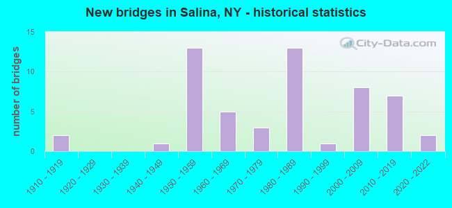
- New bridges - historical statistics
- 21910-1919
- 11940-1949
- 131950-1959
- 51960-1969
- 31970-1979
- 131980-1989
- 11990-1999
- 82000-2009
- 72010-2019
- 22020-2022
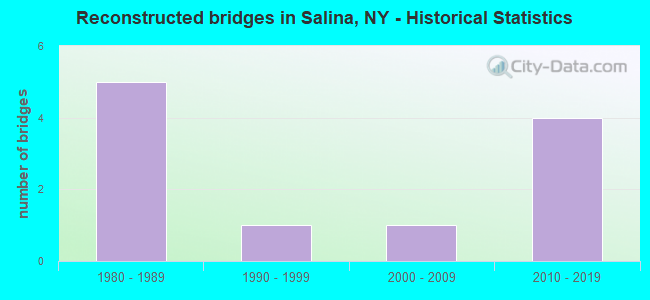
- Reconstructed bridges - Historical Statistics
- 51980-1989
- 11990-1999
- 12000-2009
- 42010-2019
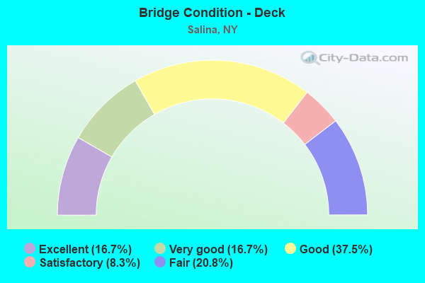
- Bridge Condition - Deck
- 16.7%Excellent
- 16.7%Very good
- 37.5%Good
- 8.3%Satisfactory
- 20.8%Fair
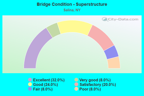
- Bridge Condition - Superstructure
- 32.0%Excellent
- 8.0%Very good
- 24.0%Good
- 20.0%Satisfactory
- 8.0%Fair
- 8.0%Poor
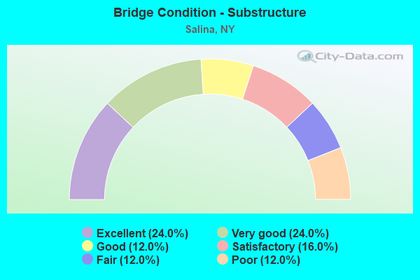
- Bridge Condition - Substructure
- 24.0%Excellent
- 24.0%Very good
- 12.0%Good
- 16.0%Satisfactory
- 12.0%Fair
- 12.0%Poor
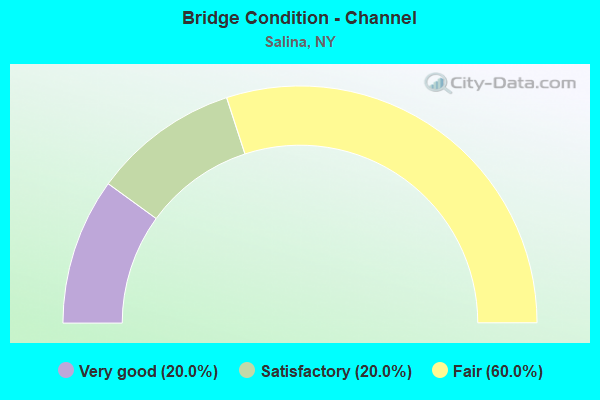
- Bridge Condition - Channel
- 20.0%Very good
- 20.0%Satisfactory
- 60.0%Fair
Find on map >> Show street view
Structure Number: 100851, Location: .1 MI S JCT US 11 & I90 (Lat: 43.089692, Lng: -76.149433), Route carried "on" structure: US 11, Year Built: 1950, Year Reconstructed: 1994, Status: Open, Structure Length: 1.89m (6.20ft), Average Daily Traffic: 4,985 (year 2016), Truck Traffic: 2%, Average Future Daily Traffic: 6,055 (year 2040), Design Load: HS 25 or greater, Features Intersected: LEY CREEK
Minimum Vertical Clearance: 30+ m (98+ ft), Kilometerpoint: 38.005, Lanes on structure: 4, Base Highway Network: Yes, Owner: State Highway Agency, Approaching Roadway Width: 15.8m (51.8ft), Skew: 3 degrees, Material/Design: Prestressed concrete, Design/Construction: Box Beam or Girders - Multiple, Number Of Spans In Main Unit: 1, Length of Maximum Span: 18.2m (59.7ft), Curb or Sidewalk Widths: Left: 2.4m (7.9ft), Right: 2.4m (7.9ft), Curb-To-Curb Width: 15.8m (51.8ft), Out-to-Out Width: 21.3m (69.9ft)
Condition: Deck: Good, Superstructure: Very good, Substructure: Good, Channel: Very good, Operating Rating: 58.0 metric tons, Method Used To Determine Operating Rating: Load and Resistance Factor Rating (LRFR) rating reported by rating factor(RF) method using HL-93 loadings, Inventory Rating: 38.2 metric tons, Method Used To Determine Inventory Rating: Load and Resistance Factor Rating (LRFR) rating reported by rating factor(RF) method using HL-93 loadings, Structural Evaluation: Better than present minimum criteria, Deck Geometry: Meets minimum limits, Waterway Adequacy: Equal to present minimum criteria, Approach Roadway Alignment: Equal to present desirable criteria, Length Of Structure Improvement: 1.88m (6.17ft), Designated Inspection Frequency: Every 24 months, Inspection Date: September 2020, Bridge Improvement Cost: $1,965,000, Roadway Improvement Cost: $1,151,000, Total Project Cost: $3,116,000 ( Estimate for 2021), Wearing Surface/Protective System: Wearing Surface: Monolithic Concrete
Find on map >> Show street view
Structure Number: 100852, Location: JCT OF RTS 11 + I-90 (Lat: 43.092175, Lng: -76.148144), Route carried "on" structure: US 11, Year Built: 2004, Status: Open, Structure Length: 6.58m (21.59ft), Average Daily Traffic: 4,985 (year 2016), Truck Traffic: 2%, Average Future Daily Traffic: 6,055 (year 2040), Design Load: HS 25 or greater, Features Intersected: 90IX EB, RTE I90
Minimum Vertical Clearance: 30+ m (98+ ft), Kilometerpoint: 38.262, Lanes on structure: 4, Lanes under structure: 4, Base Highway Network: Yes, Owner: State Toll Authority, Approaching Roadway Width: 15.8m (51.8ft), Skew: 2 degrees, Material/Design: Steel continuous, Design/Construction: Stringer/Multi-beam, Number Of Spans In Main Unit: 2, Length of Maximum Span: 32.6m (107.0ft), Curb or Sidewalk Widths: Left: 2.4m (7.9ft), Right: 2.4m (7.9ft), Curb-To-Curb Width: 15.8m (51.8ft), Out-to-Out Width: 21.2m (69.6ft)
Condition: Deck: Good, Superstructure: Excellent, Substructure: Very good, Inventory Rating: 68.9 metric tons, Method Used To Determine Inventory Rating: Load Factor (LF), Structural Evaluation: Equal to present desirable criteria, Deck Geometry: Meets minimum limits, Underclear: Meets minimum limits, Approach Roadway Alignment: Equal to present desirable criteria, Length Of Structure Improvement: 6.58m (21.59ft), Designated Inspection Frequency: Every 24 months, Inspection Date: October 2020, Bridge Improvement Cost: $2,621,000, Roadway Improvement Cost: $1,535,000, Total Project Cost: $4,155,000 ( Estimate for 2021), Deck Structure Type: Concrete Cast-file-Place, Wearing Surface/Protective System: Wearing Surface: Integral Concrete, Deck Protection: Galvanized Reinforcing
Find on map >> Show street view
Structure Number: 100853, Location: JCT US 11 NB & I81 (Lat: 43.112578, Lng: -76.145089), Route carried "on" structure: Ramp Interstate 936, Year Built: 1971, Year Reconstructed: 2018, Status: Open, Structure Length: 29.11m (95.51ft), Average Daily Traffic: 3,504 (year 2018), Truck Traffic: 5%, Average Future Daily Traffic: 4,256 (year 2040), Design Load: HS 20, Features Intersected: RTE 11, SO BAY RD-CR208
Minimum Vertical Clearance: 30+ m (98+ ft), Kilometerpoint: 1.947, Lanes on structure: 1, Lanes under structure: 5, Base Highway Network: Yes, Owner: State Highway Agency, Approaching Roadway Width: 4.6m (15.1ft), Skew: 2 degrees, Material/Design: Steel, Design/Construction: Stringer/Multi-beam, Number Of Spans In Main Unit: 8, Length of Maximum Span: 39.9m (130.9ft), Curb-To-Curb Width: 7.6m (24.9ft), Out-to-Out Width: 8.5m (27.9ft)
Condition: Deck: Good, Superstructure: Good, Substructure: Very good, Operating Rating: 76.2 metric tons, Method Used To Determine Operating Rating: Load Factor (LF), Inventory Rating: 45.4 metric tons, Method Used To Determine Inventory Rating: Load Factor (LF), Structural Evaluation: Better than present minimum criteria, Deck Geometry: Better than present minimum criteria, Underclear: High priority of corrective action, Approach Roadway Alignment: Equal to present desirable criteria, Length Of Structure Improvement: 29.10m (95.47ft), Designated Inspection Frequency: Every 24 months, Inspection Date: November 2020, Bridge Improvement Cost: $4,690,000, Roadway Improvement Cost: $2,747,000, Total Project Cost: $7,437,000 ( Estimate for 2021), Deck Structure Type: Concrete Cast-file-Place, Wearing Surface/Protective System: Wearing Surface: Integral Concrete
Find on map >> Show street view
Structure Number: 102739, Location: JCT OF I81 & SH 57 - RAMP (Lat: 43.078653, Lng: -76.177814), Route carried "on" structure: Ramp Interstate , Year Built: 1987, Status: Open, Structure Length: 9.36m (30.71ft), Average Daily Traffic: 4,690 (year 2020), Truck Traffic: 6%, Average Future Daily Traffic: 6,765 (year 2040), Design Load: HS 20, Features Intersected: RTE 370, BIKE PATH, Facility Carried by Structure: FROM CR137 TO I81
Minimum Vertical Clearance: 30+ m (98+ ft), Kilometerpoint: 0.161, Lanes on structure: 2, Lanes under structure: 3, Owner: State Highway Agency, Approaching Roadway Width: 14.6m (47.9ft), Material/Design: Steel, Design/Construction: Stringer/Multi-beam, Number Of Spans In Main Unit: 2, Length of Maximum Span: 63.3m (207.7ft), Curb-To-Curb Width: 10.5m (34.4ft), Out-to-Out Width: 11.5m (37.7ft)
Condition: Deck: Satisfactory, Superstructure: Good, Substructure: Good, Operating Rating: 36.0 metric tons, Method Used To Determine Operating Rating: Load and Resistance Factor Rating (LRFR) rating reported by rating factor(RF) method using HL-93 loadings, Inventory Rating: 27.9 metric tons, Method Used To Determine Inventory Rating: Load and Resistance Factor Rating (LRFR) rating reported by rating factor(RF) method using HL-93 loadings, Structural Evaluation: Better than present minimum criteria, Deck Geometry: Better than present minimum criteria, Underclear: Meets minimum limits, Approach Roadway Alignment: Equal to present desirable criteria, Length Of Structure Improvement: 9.35m (30.68ft), Designated Inspection Frequency: Every 24 months, Inspection Date: November 2020, Bridge Improvement Cost: $2,325,000, Roadway Improvement Cost: $1,361,000, Total Project Cost: $3,686,000 ( Estimate for 2021), Deck Structure Type: Concrete Cast-file-Place, Wearing Surface/Protective System: Wearing Surface: Integral Concrete, Deck Protection: Epoxy Coated Reinforcing
Find on map >> Show street view
Structure Number: 103164, Location: 0.3 MI.SW JCT.81I & 90I (Lat: 43.089683, Lng: -76.166772), Route carried "on" structure: County highway , Year Built: 1986, Status: Open, Structure Length: 6.19m (20.31ft), Truck Traffic: 5%, Design Load: HS 20+Mod, Features Intersected: RTE I81, Facility Carried by Structure: SEVENTH NORTH ST.
Minimum Vertical Clearance: 30+ m (98+ ft), Kilometerpoint: 0.676, Lanes on structure: 7, Lanes under structure: 8, Owner: State Highway Agency, Approaching Roadway Width: 31.7m (104.0ft), Skew: 30 degrees, Material/Design: Steel continuous, Design/Construction: Stringer/Multi-beam, Number Of Spans In Main Unit: 2, Length of Maximum Span: 31.0m (101.7ft), Curb-To-Curb Width: 31.7m (104.0ft), Out-to-Out Width: 33.8m (110.9ft)
Condition: Deck: Satisfactory, Superstructure: Satisfactory, Substructure: Satisfactory, Operating Rating: 41.1 metric tons, Method Used To Determine Operating Rating: Load and Resistance Factor Rating (LRFR) rating reported by rating factor(RF) method using HL-93 loadings, Inventory Rating: 31.8 metric tons, Method Used To Determine Inventory Rating: Load and Resistance Factor Rating (LRFR) rating reported by rating factor(RF) method using HL-93 loadings, Structural Evaluation: Equal to present minimum criteria, Deck Geometry: Superior to present desirable criteria, Underclear: High priority of corrective action, Approach Roadway Alignment: Equal to present desirable criteria, Length Of Structure Improvement: 6.18m (20.28ft), Designated Inspection Frequency: Every 24 months, Inspection Date: July 2020, Bridge Improvement Cost: $4,903,000, Roadway Improvement Cost: $2,871,000, Total Project Cost: $7,774,000 ( Estimate for 2021), Deck Structure Type: Concrete Cast-file-Place, Wearing Surface/Protective System: Wearing Surface: Integral Concrete, Deck Protection: Epoxy Coated Reinforcing
Find on map >> Show street view
Structure Number: 1031659, Location: JCT I81 & I90 (Lat: 43.093122, Lng: -76.163628), Route carried "on" structure: Interstate 81, Year Built: 1986, Year Reconstructed: 2016, Status: Open, Structure Length: 6.19m (20.31ft), Average Daily Traffic: 54,456 (year 2020), Truck Traffic: 8%, Average Future Daily Traffic: 78,552 (year 2040), Design Load: HS 20, Features Intersected: 90x, RTE I90
Minimum Vertical Clearance: 30+ m (98+ ft), Kilometerpoint: 37.248, Lanes on structure: 8, Lanes under structure: 6, Base Highway Network: Yes, Owner: State Highway Agency, Approaching Roadway Width: 39.3m (128.9ft), Skew: 21 degrees, Material/Design: Steel continuous, Design/Construction: Stringer/Multi-beam, Number Of Spans In Main Unit: 2, Length of Maximum Span: 30.4m (99.7ft), Curb-To-Curb Width: 39.2m (128.6ft), Out-to-Out Width: 40.2m (131.9ft)
Condition: Deck: Very good, Superstructure: Satisfactory, Substructure: Very good, Operating Rating: 69.9 metric tons, Method Used To Determine Operating Rating: Load Factor (LF), Inventory Rating: 41.7 metric tons, Method Used To Determine Inventory Rating: Load Factor (LF), Structural Evaluation: Equal to present minimum criteria, Deck Geometry: Superior to present desirable criteria, Underclear: High priority of corrective action, Approach Roadway Alignment: Equal to present desirable criteria, Length Of Structure Improvement: 6.18m (20.28ft), Designated Inspection Frequency: Every 24 months, Inspection Date: November 2020, Bridge Improvement Cost: $6,120,000, Roadway Improvement Cost: $3,584,000, Total Project Cost: $9,704,000 ( Estimate for 2021), Deck Structure Type: Concrete Cast-file-Place, Wearing Surface/Protective System: Wearing Surface: Integral Concrete, Deck Protection: Epoxy Coated Reinforcing
Find on map >> Show street view
Structure Number: 103166, Location: .2 MI NE JCT I81 & I90 (Lat: 43.094783, Lng: -76.162092), Route carried "on" structure: Ramp Interstate , Year Built: 1986, Status: Open, Structure Length: 6.25m (20.51ft), Average Daily Traffic: 2,076 (year 2018), Truck Traffic: 14%, Average Future Daily Traffic: 2,994 (year 2040), Design Load: HS 20, Features Intersected: 81I 81I33033013 NB, RTE, Facility Carried by Structure: RAMP TO I81NB&I90
Minimum Vertical Clearance: 30+ m (98+ ft), Kilometerpoint: 1.786, Lanes on structure: 2, Lanes under structure: 6, Owner: State Highway Agency, Approaching Roadway Width: 15.5m (50.9ft), Skew: 20 degrees, Material/Design: Steel continuous, Design/Construction: Stringer/Multi-beam, Number Of Spans In Main Unit: 2, Length of Maximum Span: 30.7m (100.7ft), Curb-To-Curb Width: 15.5m (50.9ft), Out-to-Out Width: 16.4m (53.8ft)
Condition: Deck: Fair, Superstructure: Satisfactory, Substructure: Fair, Operating Rating: 64.4 metric tons, Method Used To Determine Operating Rating: Load Factor (LF), Inventory Rating: 38.1 metric tons, Method Used To Determine Inventory Rating: Load Factor (LF), Structural Evaluation: Somewhat better than minimum adequacy, Deck Geometry: Superior to present desirable criteria, Underclear: High priority of corrective action, Approach Roadway Alignment: Equal to present desirable criteria, Length Of Structure Improvement: 6.24m (20.47ft), Designated Inspection Frequency: Every 24 months, Inspection Date: October 2021, Bridge Improvement Cost: $2,323,000, Roadway Improvement Cost: $1,361,000, Total Project Cost: $3,684,000 ( Estimate for 2021), Deck Structure Type: Concrete Cast-file-Place, Wearing Surface/Protective System: Wearing Surface: Integral Concrete, Deck Protection: Epoxy Coated Reinforcing
Find on map >> Show street view
Structure Number: 1031671, Location: JCT I81 & US 11 (Lat: 43.111403, Lng: -76.146153), Route carried "on" structure: Interstate 81, Year Built: 1959, Year Reconstructed: 2017, Status: Open, Structure Length: 54.01m (177.20ft), Average Daily Traffic: 43,836 (year 2005), Truck Traffic: 13%, Design Load: HS 20, Features Intersected: 11 11 33033021, RTE 11,
Minimum Vertical Clearance: 30+ m (98+ ft), Kilometerpoint: 39.388, Lanes on structure: 3, Lanes under structure: 8, Base Highway Network: Yes, Owner: State Highway Agency, Approaching Roadway Width: 16.8m (55.1ft), Material/Design: Steel, Design/Construction: Stringer/Multi-beam, Number Of Spans In Main Unit: 26, Length of Maximum Span: 35.0m (114.8ft), Curb-To-Curb Width: 16.6m (54.5ft), Out-to-Out Width: 17.6m (57.7ft)
Condition: Deck: Good, Superstructure: Good, Substructure: Good, Operating Rating: 63.5 metric tons, Method Used To Determine Operating Rating: Load Factor (LF), Inventory Rating: 33.6 metric tons, Method Used To Determine Inventory Rating: Load Factor (LF), Structural Evaluation: Better than present minimum criteria, Deck Geometry: Equal to present minimum criteria, Underclear: High priority of corrective action, Approach Roadway Alignment: Equal to present desirable criteria, Length Of Structure Improvement: 54.01m (177.20ft), Designated Inspection Frequency: Every 24 months, Critical Feature Inspection Frequency: Every 24 months, Inspection Date: October 2020, Critical Feature Inspection Date: October 2020, Bridge Improvement Cost: $17,473,000, Roadway Improvement Cost: $10,232,000, Total Project Cost: $27,705,000 ( Estimate for 2021), Deck Structure Type: Concrete Cast-file-Place, Wearing Surface/Protective System: Wearing Surface: Epoxy Overlay, Deck Protection: Epoxy Coated Reinforcing
Find on map >> Show street view
Structure Number: 1031672, Location: JCT US 11 & I81 (Lat: 43.111206, Lng: -76.146039), Route carried "on" structure: Interstate 81, Year Built: 1989, Year Reconstructed: 2017, Status: Open, Structure Length: 54.25m (177.99ft), Average Daily Traffic: 27,228 (year 2020), Truck Traffic: 11%, Average Future Daily Traffic: 39,276 (year 2040), Design Load: HS 20, Features Intersected: 11 11 33033022, RTE 11,
Minimum Vertical Clearance: 30+ m (98+ ft), Kilometerpoint: 39.404, Lanes on structure: 3, Lanes under structure: 7, Base Highway Network: Yes, Owner: State Highway Agency, Approaching Roadway Width: 16.3m (53.5ft), Material/Design: Steel continuous, Design/Construction: Stringer/Multi-beam, Number Of Spans In Main Unit: 11, Length of Maximum Span: 79.2m (259.8ft), Curb-To-Curb Width: 16.3m (53.5ft), Out-to-Out Width: 17.3m (56.8ft)
Condition: Deck: Good, Superstructure: Good, Substructure: Satisfactory, Operating Rating: 44.5 metric tons, Method Used To Determine Operating Rating: Load Factor (LF), Inventory Rating: 32.7 metric tons, Method Used To Determine Inventory Rating: Load Factor (LF), Structural Evaluation: Equal to present minimum criteria, Deck Geometry: Equal to present minimum criteria, Underclear: High priority of corrective action, Approach Roadway Alignment: Equal to present desirable criteria, Length Of Structure Improvement: 54.25m (177.99ft), Designated Inspection Frequency: Every 24 months, Inspection Date: October 2020, Bridge Improvement Cost: $17,580,000, Roadway Improvement Cost: $10,295,000, Total Project Cost: $27,874,000 ( Estimate for 2021), Deck Structure Type: Concrete Cast-file-Place, Wearing Surface/Protective System: Wearing Surface: Epoxy Overlay, Deck Protection: Epoxy Coated Reinforcing
Find on map >> Show street view
Structure Number: 1031681, Location: .6 MI NE JCT RTS I-81 +11 (Lat: 43.115900, Lng: -76.136067), Route carried "on" structure: County highway , Year Built: 1963, Year Reconstructed: 1992, Status: Open, Structure Length: 13.81m (45.31ft), Average Daily Traffic: 2,761 (year 2015), Truck Traffic: 3%, Average Future Daily Traffic: 3,353 (year 2040), Design Load: HS 20, Features Intersected: 81I 81I33033033 SB, Rout, Facility Carried by Structure: AIRPORT BLVD (WB)
Minimum Vertical Clearance: 30+ m (98+ ft), Kilometerpoint: 0.676, Lanes on structure: 2, Lanes under structure: 11, Owner: State Highway Agency, Approaching Roadway Width: 8.5m (27.9ft), Skew: 1 degrees, Material/Design: Steel, Design/Construction: Stringer/Multi-beam, Number Of Spans In Main Unit: 7, Length of Maximum Span: 23.2m (76.1ft), Curb or Sidewalk Widths: Left: 0.0m, Right: 0.5m (1.6ft), Curb-To-Curb Width: 8.5m (27.9ft), Out-to-Out Width: 10.9m (35.8ft)
Condition: Deck: Fair, Superstructure: Poor, Substructure: Poor, Operating Rating: 34.7 metric tons, Method Used To Determine Operating Rating: Load and Resistance Factor Rating (LRFR) rating reported by rating factor(RF) method using HL-93 loadings, Inventory Rating: 26.6 metric tons, Method Used To Determine Inventory Rating: Load and Resistance Factor Rating (LRFR) rating reported by rating factor(RF) method using HL-93 loadings, Structural Evaluation: Meets minimum limits, Deck Geometry: High priority of corrective action, Underclear: High priority of corrective action, Approach Roadway Alignment: Equal to present desirable criteria, Length Of Structure Improvement: 13.80m (45.28ft), Designated Inspection Frequency: Every 24 months, Inspection Date: May 2021, Bridge Improvement Cost: $2,860,000, Roadway Improvement Cost: $1,675,000, Total Project Cost: $4,534,000 ( Estimate for 2021), Deck Structure Type: Concrete Cast-file-Place, Wearing Surface/Protective System: Wearing Surface: Latex Concrete
Find on map >> Show street view
Structure Number: 1031682, Location: .6 MI NE JCT RTS I-81 +11 (Lat: 43.115989, Lng: -76.135858), Route carried "on" structure: County highway , Year Built: 1963, Year Reconstructed: 1992, Status: Open, Structure Length: 13.81m (45.31ft), Average Daily Traffic: 2,761 (year 2015), Truck Traffic: 3%, Average Future Daily Traffic: 3,353 (year 2040), Design Load: HS 20, Features Intersected: Route 936A, 81I 81I33033, Facility Carried by Structure: AIRPORT BLVD (EB)
Minimum Vertical Clearance: 30+ m (98+ ft), Kilometerpoint: 0.708, Lanes on structure: 2, Lanes under structure: 11, Owner: State Highway Agency, Approaching Roadway Width: 8.5m (27.9ft), Skew: 1 degrees, Material/Design: Steel, Design/Construction: Stringer/Multi-beam, Number Of Spans In Main Unit: 7, Length of Maximum Span: 23.2m (76.1ft), Curb or Sidewalk Widths: Left: 0.5m (1.6ft), Right: 0.9m (3.0ft), Curb-To-Curb Width: 8.5m (27.9ft), Out-to-Out Width: 10.9m (35.8ft)
Condition: Deck: Fair, Superstructure: Poor, Substructure: Poor, Operating Rating: 60.8 metric tons, Method Used To Determine Operating Rating: Load Factor (LF), Inventory Rating: 36.3 metric tons, Method Used To Determine Inventory Rating: Load Factor (LF), Structural Evaluation: Meets minimum limits, Deck Geometry: High priority of corrective action, Underclear: High priority of corrective action, Approach Roadway Alignment: Equal to present desirable criteria, Length Of Structure Improvement: 13.80m (45.28ft), Designated Inspection Frequency: Every 24 months, Inspection Date: May 2021, Bridge Improvement Cost: $2,985,000, Roadway Improvement Cost: $1,748,000, Total Project Cost: $4,733,000 ( Estimate for 2021), Deck Structure Type: Concrete Cast-file-Place, Wearing Surface/Protective System: Wearing Surface: Latex Concrete
Find on map >> Show street view
Structure Number: 104687, Location: JCT OF RTS 370 + I-90 (Lat: 43.118081, Lng: -76.226514), Route carried "on" structure: State highway 370, Year Built: 2011, Status: Open, Structure Length: 7.16m (23.49ft), Average Daily Traffic: 5,701 (year 2019), Truck Traffic: 3%, Average Future Daily Traffic: 6,925 (year 2040), Design Load: HL 93, Features Intersected: 90IX EB, RTE I90
Minimum Vertical Clearance: 30+ m (98+ ft), Kilometerpoint: 21.947, Lanes on structure: 2, Lanes under structure: 4, Base Highway Network: Yes, Owner: State Toll Authority, Approaching Roadway Width: 12.2m (40.0ft), Skew: 4 degrees, Material/Design: Steel continuous, Design/Construction: Stringer/Multi-beam, Number Of Spans In Main Unit: 2, Length of Maximum Span: 34.7m (113.8ft), Curb or Sidewalk Widths: Left: 1.7m (5.6ft), Right: 1.7m (5.6ft), Curb-To-Curb Width: 9.2m (30.2ft), Out-to-Out Width: 13.1m (43.0ft)
Condition: Deck: Very good, Superstructure: Excellent, Substructure: Excellent, Operating Rating: 83.5 metric tons, Method Used To Determine Operating Rating: Load Factor (LF), Inventory Rating: 49.9 metric tons, Method Used To Determine Inventory Rating: Load Factor (LF), Structural Evaluation: Superior to present desirable criteria, Deck Geometry: Meets minimum limits, Underclear: Meets minimum limits, Approach Roadway Alignment: Equal to present desirable criteria, Length Of Structure Improvement: 7.16m (23.49ft), Designated Inspection Frequency: Every 24 months, Inspection Date: August 2021, Bridge Improvement Cost: $2,613,000, Roadway Improvement Cost: $1,530,000, Total Project Cost: $4,144,000 ( Estimate for 2021), Deck Structure Type: Concrete Cast-file-Place, Wearing Surface/Protective System: Wearing Surface: Integral Concrete, Deck Protection: Galvanized Reinforcing
Find on map >> Show street view
Structure Number: 104982, Location: .5 MI S JCT LEMOYNE + 90I (Lat: 43.090111, Lng: -76.145131), Route carried "on" structure: County highway 930A, Year Built: 1950, Year Reconstructed: 1993, Status: Open, Structure Length: 1.65m (5.41ft), Average Daily Traffic: 8,313 (year 2016), Truck Traffic: 3%, Average Future Daily Traffic: 10,098 (year 2040), Design Load: HS 20, Features Intersected: LEY CREEK
Minimum Vertical Clearance: 30+ m (98+ ft), Kilometerpoint: 0.660, Lanes on structure: 4, Owner: County Highway Agency, Approaching Roadway Width: 15.8m (51.8ft), Material/Design: Steel, Design/Construction: Stringer/Multi-beam, Number Of Spans In Main Unit: 1, Length of Maximum Span: 15.2m (49.9ft), Curb or Sidewalk Widths: Left: 2.7m (8.9ft), Right: 2.7m (8.9ft), Curb-To-Curb Width: 15.8m (51.8ft), Out-to-Out Width: 21.8m (71.5ft)
Condition: Deck: Good, Superstructure: Satisfactory, Substructure: Satisfactory, Channel: Satisfactory, Operating Rating: 85.3 metric tons, Method Used To Determine Operating Rating: Load Factor (LF), Inventory Rating: 50.8 metric tons, Method Used To Determine Inventory Rating: Load Factor (LF), Structural Evaluation: Equal to present minimum criteria, Deck Geometry: Meets minimum limits, Waterway Adequacy: Equal to present minimum criteria, Approach Roadway Alignment: Equal to present desirable criteria, Length Of Structure Improvement: 1.64m (5.38ft), Designated Inspection Frequency: Every 24 months, Inspection Date: November 2021, Bridge Improvement Cost: $1,418,000, Roadway Improvement Cost: $830,000, Total Project Cost: $2,248,000 ( Estimate for 2021), Deck Structure Type: Concrete Cast-file-Place, Wearing Surface/Protective System: Wearing Surface: Bituminous, Membrane: Other, Deck Protection: Epoxy Coated Reinforcing
Find on map >> Show street view
Structure Number: 104983, Location: JCT OF LEMOYNE + I-09 (Lat: 43.092117, Lng: -76.145294), Route carried "on" structure: County highway , Year Built: 2004, Status: Open, Structure Length: 6.13m (20.11ft), Average Daily Traffic: 8,313 (year 2016), Truck Traffic: 3%, Average Future Daily Traffic: 10,098 (year 2040), Design Load: HS 25 or greater, Features Intersected: 90IX EB, RTE I90, Facility Carried by Structure: LEMOYNE AVE CR219
Minimum Vertical Clearance: 30+ m (98+ ft), Kilometerpoint: 0.853, Lanes on structure: 4, Lanes under structure: 4, Owner: State Toll Authority, Approaching Roadway Width: 15.8m (51.8ft), Material/Design: Steel continuous, Design/Construction: Stringer/Multi-beam, Number Of Spans In Main Unit: 2, Length of Maximum Span: 30.5m (100.1ft), Curb or Sidewalk Widths: Left: 2.4m (7.9ft), Right: 2.4m (7.9ft), Curb-To-Curb Width: 15.8m (51.8ft), Out-to-Out Width: 21.4m (70.2ft)
Condition: Deck: Very good, Superstructure: Excellent, Substructure: Very good, Inventory Rating: 59.9 metric tons, Method Used To Determine Inventory Rating: Load Factor (LF), Structural Evaluation: Equal to present desirable criteria, Deck Geometry: Meets minimum limits, Underclear: Meets minimum limits, Approach Roadway Alignment: Equal to present desirable criteria, Length Of Structure Improvement: 6.12m (20.08ft), Designated Inspection Frequency: Every 24 months, Inspection Date: September 2021, Bridge Improvement Cost: $2,462,000, Roadway Improvement Cost: $1,442,000, Total Project Cost: $3,903,000 ( Estimate for 2021), Deck Structure Type: Concrete Cast-file-Place, Wearing Surface/Protective System: Wearing Surface: Integral Concrete, Deck Protection: Galvanized Reinforcing
Find on map >> Show street view
Structure Number: 331279, Location: 1.3 MI W EXIT 35 OF I90 (Lat: 43.090906, Lng: -76.116608), Route carried "on" structure: County highway , Year Built: 1951, Year Reconstructed: 2006, Status: Open, Structure Length: 1.77m (5.81ft), Average Daily Traffic: 9,788 (year 2017), Truck Traffic: 6%, Average Future Daily Traffic: 11,890 (year 2040), Design Load: HS 20, Features Intersected: LEY CREEK, Facility Carried by Structure: SALINA-DEWITT RD
Minimum Vertical Clearance: 30+ m (98+ ft), Kilometerpoint: 0.386, Lanes on structure: 4, Owner: County Highway Agency, Approaching Roadway Width: 20.4m (66.9ft), Material/Design: Steel, Design/Construction: Stringer/Multi-beam, Number Of Spans In Main Unit: 1, Length of Maximum Span: 16.3m (53.5ft), Curb-To-Curb Width: 20.4m (66.9ft), Out-to-Out Width: 21.4m (70.2ft)
Condition: Deck: Good, Superstructure: Good, Substructure: Fair, Channel: Fair, Operating Rating: 66.1 metric tons, Method Used To Determine Operating Rating: Load and Resistance Factor Rating (LRFR) rating reported by rating factor(RF) method using HL-93 loadings, Inventory Rating: 50.5 metric tons, Method Used To Determine Inventory Rating: Load and Resistance Factor Rating (LRFR) rating reported by rating factor(RF) method using HL-93 loadings, Structural Evaluation: Somewhat better than minimum adequacy, Deck Geometry: Superior to present desirable criteria, Waterway Adequacy: Meets minimum limits, Approach Roadway Alignment: Equal to present desirable criteria, Length Of Structure Improvement: 1.76m (5.77ft), Designated Inspection Frequency: Every 24 months, Inspection Date: November 2020, Bridge Improvement Cost: $1,250,000, Roadway Improvement Cost: $732,000, Total Project Cost: $1,982,000 ( Estimate for 2021), Deck Structure Type: Concrete Cast-file-Place, Wearing Surface/Protective System: Wearing Surface: Integral Concrete, Deck Protection: Epoxy Coated Reinforcing
Find on map >> Show street view
Structure Number: 331286, Location: .5 MI SE OF EXIT 25 - I81 (Lat: 43.086100, Lng: -76.162453), Route carried "on" structure: County highway , Year Built: 1993, Status: Open, Structure Length: 0.82m (2.69ft), Average Daily Traffic: 7,723 (year 2019), Truck Traffic: 5%, Average Future Daily Traffic: 9,381 (year 2040), Design Load: HS 20, Features Intersected: LEY CREEK, Facility Carried by Structure: 7TH NORTH STREET
Minimum Vertical Clearance: 30+ m (98+ ft), Kilometerpoint: 0.338, Lanes on structure: 2, Owner: County Highway Agency, Approaching Roadway Width: 7.3m (24.0ft), Material/Design: Aluminum, Iron, Design/Construction: Arch - Deck, Number Of Spans In Main Unit: 1, Length of Maximum Span: 7.3m (24.0ft), Curb-To-Curb Width: 11.0m (36.1ft), Out-to-Out Width: 14.0m (45.9ft)
Condition: Superstructure: Good, Substructure: Very good, Channel: Fair, Operating Rating: 77.7 metric tons, Method Used To Determine Operating Rating: Field evaluation and documented engineering judgment, Inventory Rating: 32.7 metric tons, Method Used To Determine Inventory Rating: Field evaluation and documented engineering judgment, Structural Evaluation: Better than present minimum criteria, Deck Geometry: Meets minimum limits, Waterway Adequacy: Meets minimum limits, Approach Roadway Alignment: Equal to present desirable criteria, Length Of Structure Improvement: 0.82m (2.69ft), Designated Inspection Frequency: Every 24 months, Underwater Inspection Frequency: Every 60 months, Inspection Date: September 2021, Underwater Inspection Date: June 2019, Bridge Improvement Cost: $208,000, Roadway Improvement Cost: $122,000, Total Project Cost: $329,000 ( Estimate for 2021), Wearing Surface/Protective System: Wearing Surface: Bituminous
Find on map >> Show street view
Structure Number: 502741, Location: 0.3MI E EXIT 38 OVER I90 (Lat: 43.115617, Lng: -76.213306), Route carried "on" structure: County highway , Year Built: 1952, Year Reconstructed: 1987, Status: Open, Structure Length: 5.15m (16.90ft), Average Daily Traffic: 17,577 (year 2019), Truck Traffic: 3%, Average Future Daily Traffic: 17,659 (year 2040), Design Load: HS 20+Mod, Features Intersected: 90IX, RTE I90, Facility Carried by Structure: CR57 OSWEGO ST
Minimum Vertical Clearance: 30+ m (98+ ft), Kilometerpoint: 1.335, Lanes on structure: 4, Lanes under structure: 6, Owner: State Toll Authority, Approaching Roadway Width: 20.4m (66.9ft), Skew: 3 degrees, Material/Design: Steel, Design/Construction: Stringer/Multi-beam, Number Of Spans In Main Unit: 2, Length of Maximum Span: 25.6m (84.0ft), Curb or Sidewalk Widths: Left: 0.5m (1.6ft), Right: 0.5m (1.6ft), Curb-To-Curb Width: 19.2m (63.0ft), Out-to-Out Width: 20.1m (65.9ft)
Condition: Deck: Fair, Superstructure: Satisfactory, Substructure: Poor, Operating Rating: 77.1 metric tons, Method Used To Determine Operating Rating: Load Factor (LF), Inventory Rating: 46.3 metric tons, Method Used To Determine Inventory Rating: Load Factor (LF), Structural Evaluation: Meets minimum limits, Deck Geometry: Equal to present minimum criteria, Underclear: High priority of corrective action, Approach Roadway Alignment: Equal to present desirable criteria, Length Of Structure Improvement: 5.15m (16.90ft), Designated Inspection Frequency: Every 24 months, Inspection Date: September 2020, Bridge Improvement Cost: $2,944,000, Roadway Improvement Cost: $1,724,000, Total Project Cost: $4,667,000 ( Estimate for 2021), Deck Structure Type: Concrete Cast-file-Place, Wearing Surface/Protective System: Wearing Surface: Integral Concrete, Deck Protection: Epoxy Coated Reinforcing
Find on map >> Show street view
Structure Number: 551013, Location: .1 MI E JCT I81 & I90 (Lat: 43.092525, Lng: -76.162342), Route carried "on" structure: Interstate 90, Year Built: 1946, Year Reconstructed: 1998, Status: Open, Structure Length: 0.91m (2.99ft), Average Daily Traffic: 22,817 (year 2020), Truck Traffic: 25%, Average Future Daily Traffic: 32,913 (year 2040), Design Load: HS 20+Mod, Features Intersected: BEAR TRAP CREEK
Minimum Vertical Clearance: 30+ m (98+ ft), Kilometerpoint: 28.978, Lanes on structure: 5, Base Highway Network: Yes, Toll: On Interstate toll segment, Owner: State Toll Authority, Approaching Roadway Width: 24.1m (79.1ft), Skew: 22 degrees, Material/Design: Concrete, Design/Construction: Culvert, Number Of Spans In Main Unit: 2, Length of Maximum Span: 4.3m (14.1ft)
Condition: Channel: Fair, Culverts: Poor, Operating Rating: 89.8 metric tons, Method Used To Determine Operating Rating: Load Factor (LF), Inventory Rating: 59.0 metric tons, Method Used To Determine Inventory Rating: Load Factor (LF), Structural Evaluation: Meets minimum limits, Waterway Adequacy: Meets minimum limits, Approach Roadway Alignment: Equal to present desirable criteria, Length Of Structure Improvement: 0.91m (2.99ft), Designated Inspection Frequency: Every 12 months, Inspection Date: May 2021, Bridge Improvement Cost: $888,000, Roadway Improvement Cost: $520,000, Total Project Cost: $1,409,000 ( Estimate for 2021)
Find on map >> Show street view
Structure Number: 551014, Location: AT EXIT 36 OF I90 (Lat: 43.094472, Lng: -76.167853), Route carried "on" structure: Ramp Interstate , Year Built: 2016, Status: Open, Structure Length: 5.73m (18.80ft), Average Daily Traffic: 4,312 (year 2018), Truck Traffic: 14%, Average Future Daily Traffic: 6,220 (year 2040), Design Load: HL 93, Features Intersected: 90 IX EB, RTE I90, Facility Carried by Structure: EXIT 36 RAMP
Minimum Vertical Clearance: 30+ m (98+ ft), Kilometerpoint: 1.158, Lanes on structure: 3, Lanes under structure: 5, Toll: On toll road, Owner: State Toll Authority, Approaching Roadway Width: 20.1m (65.9ft), Skew: 21 degrees, Material/Design: Steel, Design/Construction: Stringer/Multi-beam, Number Of Spans In Main Unit: 2, Length of Maximum Span: 30.5m (100.1ft), Curb-To-Curb Width: 20.1m (65.9ft), Out-to-Out Width: 21.6m (70.9ft)
Condition: Deck: Excellent, Superstructure: Excellent, Substructure: Excellent, Operating Rating: 52.8 metric tons, Method Used To Determine Operating Rating: Load and Resistance Factor Rating (LRFR) rating reported by rating factor(RF) method using HL-93 loadings, Inventory Rating: 47.3 metric tons, Method Used To Determine Inventory Rating: Load and Resistance Factor Rating (LRFR) rating reported by rating factor(RF) method using HL-93 loadings, Structural Evaluation: Superior to present desirable criteria, Deck Geometry: Superior to present desirable criteria, Underclear: Equal to present minimum criteria, Approach Roadway Alignment: Equal to present desirable criteria, Length Of Structure Improvement: 5.73m (18.80ft), Designated Inspection Frequency: Every 24 months, Inspection Date: September 2020, Bridge Improvement Cost: $3,202,000, Roadway Improvement Cost: $1,875,000, Total Project Cost: $5,077,000 ( Estimate for 2021), Deck Structure Type: Concrete Cast-file-Place, Wearing Surface/Protective System: Wearing Surface: Integral Concrete, Deck Protection: Galvanized Reinforcing
Find on map >> Show street view
Structure Number: 551015, Location: .3MI W EXIT 36 ON I-90 (Lat: 43.095217, Lng: -76.169789), Route carried "on" structure: County highway , Year Built: 2009, Status: Open, Structure Length: 5.73m (18.80ft), Average Daily Traffic: 10,235 (year 2016), Truck Traffic: 5%, Average Future Daily Traffic: 12,433 (year 2040), Design Load: HS 25 or greater, Features Intersected: 90IX EB, RTE I90, Facility Carried by Structure: BUCKLEY RD CR 48
Minimum Vertical Clearance: 30+ m (98+ ft), Kilometerpoint: 1.738, Lanes on structure: 3, Lanes under structure: 6, Owner: State Toll Authority, Approaching Roadway Width: 11.6m (38.1ft), Material/Design: Steel, Design/Construction: Stringer/Multi-beam, Number Of Spans In Main Unit: 2, Length of Maximum Span: 28.3m (92.8ft), Curb or Sidewalk Widths: Left: 1.7m (5.6ft), Right: 1.7m (5.6ft), Curb-To-Curb Width: 11.7m (38.4ft), Out-to-Out Width: 15.6m (51.2ft)
Condition: Deck: Very good, Superstructure: Excellent, Substructure: Excellent, Operating Rating: 67.1 metric tons, Method Used To Determine Operating Rating: Load Factor (LF), Inventory Rating: 39.9 metric tons, Method Used To Determine Inventory Rating: Load Factor (LF), Structural Evaluation: Superior to present desirable criteria, Deck Geometry: High priority of corrective action, Underclear: Equal to present minimum criteria, Approach Roadway Alignment: Equal to present desirable criteria, Length Of Structure Improvement: 5.73m (18.80ft), Designated Inspection Frequency: Every 24 months, Inspection Date: September 2021, Bridge Improvement Cost: $2,099,000, Roadway Improvement Cost: $1,229,000, Total Project Cost: $3,328,000 ( Estimate for 2021), Deck Structure Type: Concrete Cast-file-Place, Wearing Surface/Protective System: Wearing Surface: Integral Concrete, Deck Protection: Other Coated Reinforcing
Find on map >> Show street view
Structure Number: 551016, Location: RAMP BRIDGE EXIT 37 I90 (Lat: 43.102144, Lng: -76.181311), Route carried "on" structure: Ramp Interstate , Year Built: 2020, Status: Open, Structure Length: 6.68m (21.92ft), Average Daily Traffic: 1,511 (year 2019), Truck Traffic: 14%, Average Future Daily Traffic: 2,179 (year 2040), Design Load: HL 93, Features Intersected: 90IX EB, RTE I90, Facility Carried by Structure: EXIT 37 RAMP
Minimum Vertical Clearance: 30+ m (98+ ft), Kilometerpoint: 0.917, Lanes on structure: 2, Lanes under structure: 5, Toll: On Interstate toll segment, Owner: State Toll Authority, Approaching Roadway Width: 15.8m (51.8ft), Skew: 30 degrees, Material/Design: Steel, Design/Construction: Stringer/Multi-beam, Number Of Spans In Main Unit: 2, Length of Maximum Span: 34.4m (112.9ft), Curb-To-Curb Width: 15.8m (51.8ft), Out-to-Out Width: 17.0m (55.8ft)
Condition: Deck: Excellent, Superstructure: Excellent, Substructure: Excellent, Operating Rating: 53.5 metric tons, Method Used To Determine Operating Rating: Load Factor (LF), Inventory Rating: 31.8 metric tons, Method Used To Determine Inventory Rating: Load Factor (LF), Structural Evaluation: Better than present minimum criteria, Deck Geometry: Superior to present desirable criteria, Underclear: Somewhat better than minimum adequacy, Approach Roadway Alignment: Equal to present desirable criteria, Length Of Structure Improvement: 6.67m (21.88ft), Designated Inspection Frequency: Every 24 months, Inspection Date: November 2020, Bridge Improvement Cost: $2,237,000, Roadway Improvement Cost: $1,310,000, Total Project Cost: $3,547,000 ( Estimate for 2021), Deck Structure Type: Concrete Cast-file-Place, Wearing Surface/Protective System: Wearing Surface: Integral Concrete, Deck Protection: Galvanized Reinforcing
Find on map >> Show street view
Structure Number: 551017, Location: 1MI NW THRUWAY EXIT 35 (Lat: 43.109022, Lng: -76.197533), Route carried "on" structure: Interstate 90, Year Built: 2019, Status: Open, Structure Length: 3.35m (10.99ft), Average Daily Traffic: 28,225 (year 2020), Truck Traffic: 25%, Average Future Daily Traffic: 40,714 (year 2040), Design Load: HL 93, Features Intersected: CSX RR
Minimum Vertical Clearance: 30+ m (98+ ft), Kilometerpoint: 25.567, Lanes on structure: 4, Base Highway Network: Yes, Toll: On Interstate toll segment, Owner: State Toll Authority, Approaching Roadway Width: 28.0m (91.9ft), Skew: 30 degrees, Material/Design: Steel, Design/Construction: Stringer/Multi-beam, Number Of Spans In Main Unit: 1, Length of Maximum Span: 32.3m (106.0ft), Curb-To-Curb Width: 35.4m (116.1ft), Out-to-Out Width: 36.3m (119.1ft)
Condition: Deck: Excellent, Superstructure: Excellent, Substructure: Excellent, Operating Rating: 89.8 metric tons, Method Used To Determine Operating Rating: Load Factor (LF), Inventory Rating: 69.9 metric tons, Method Used To Determine Inventory Rating: Load Factor (LF), Structural Evaluation: Superior to present desirable criteria, Deck Geometry: Superior to present desirable criteria, Underclear: Superior to present desirable criteria, Approach Roadway Alignment: Equal to present desirable criteria, Length Of Structure Improvement: 3.35m (10.99ft), Designated Inspection Frequency: Every 24 months, Inspection Date: October 2021, Bridge Improvement Cost: $3,050,000, Roadway Improvement Cost: $1,786,000, Total Project Cost: $4,836,000 ( Estimate for 2021), Deck Structure Type: Concrete Cast-file-Place, Wearing Surface/Protective System: Wearing Surface: Integral Concrete, Deck Protection: Galvanized Reinforcing
Find on map >> Show street view
Structure Number: 551018, Location: 2.1 MI NW JCT I90 & I81 (Lat: 43.109450, Lng: -76.198522), Route carried "on" structure: Interstate 90, Year Built: 2019, Status: Open, Structure Length: 3.29m (10.79ft), Average Daily Traffic: 28,225 (year 2020), Truck Traffic: 25%, Average Future Daily Traffic: 40,714 (year 2040), Design Load: HL 93, Features Intersected: VINE ST CR 51
Minimum Vertical Clearance: 30+ m (98+ ft), Kilometerpoint: 25.470, Lanes on structure: 4, Lanes under structure: 2, Base Highway Network: Yes, Toll: On Interstate toll segment, Owner: State Toll Authority, Approaching Roadway Width: 29.3m (96.1ft), Skew: 31 degrees, Material/Design: Steel, Design/Construction: Stringer/Multi-beam, Number Of Spans In Main Unit: 1, Length of Maximum Span: 32.3m (106.0ft), Curb-To-Curb Width: 35.4m (116.1ft), Out-to-Out Width: 36.3m (119.1ft)
Condition: Deck: Excellent, Superstructure: Excellent, Substructure: Excellent, Operating Rating: 89.8 metric tons, Method Used To Determine Operating Rating: Load Factor (LF), Inventory Rating: 36.3 metric tons, Method Used To Determine Inventory Rating: Load Factor (LF), Structural Evaluation: Superior to present desirable criteria, Deck Geometry: Superior to present desirable criteria, Underclear: Equal to present minimum criteria, Approach Roadway Alignment: Equal to present desirable criteria, Length Of Structure Improvement: 3.29m (10.79ft), Designated Inspection Frequency: Every 24 months, Inspection Date: October 2021, Bridge Improvement Cost: $2,327,000, Roadway Improvement Cost: $1,363,000, Total Project Cost: $3,689,000 ( Estimate for 2021), Deck Structure Type: Concrete Cast-file-Place, Wearing Surface/Protective System: Wearing Surface: Integral Concrete, Deck Protection: Galvanized Reinforcing
Find on map >> Show street view
Structure Number: 55102, Location: EXIT 38 OF I90 (Lat: 43.117028, Lng: -76.218511), Route carried "on" structure: Ramp Interstate , Year Built: 1954, Status: Open, Structure Length: 6.28m (20.60ft), Average Daily Traffic: 769 (year 2019), Truck Traffic: 14%, Average Future Daily Traffic: 1,109 (year 2040), Design Load: HS 20+Mod, Features Intersected: 90IX EB, RTE I90, Facility Carried by Structure: EXIT 38 RAMP
Minimum Vertical Clearance: 30+ m (98+ ft), Kilometerpoint: 0.402, Lanes on structure: 2, Lanes under structure: 5, Toll: On Interstate toll segment, Owner: State Toll Authority, Approaching Roadway Width: 14.6m (47.9ft), Skew: 20 degrees, Material/Design: Steel, Design/Construction: Stringer/Multi-beam, Number Of Spans In Main Unit: 4, Length of Maximum Span: 19.8m (65.0ft), Curb-To-Curb Width: 11.8m (38.7ft), Out-to-Out Width: 13.1m (43.0ft)
Condition: Deck: Fair, Superstructure: Fair, Substructure: Fair, Operating Rating: 51.7 metric tons, Method Used To Determine Operating Rating: Load Factor (LF), Inventory Rating: 30.8 metric tons, Method Used To Determine Inventory Rating: Load Factor (LF), Structural Evaluation: Somewhat better than minimum adequacy, Deck Geometry: Superior to present desirable criteria, Underclear: High priority of corrective action, Approach Roadway Alignment: Equal to present desirable criteria, Length Of Structure Improvement: 6.27m (20.57ft), Designated Inspection Frequency: Every 24 months, Inspection Date: October 2021, Bridge Improvement Cost: $1,662,000, Roadway Improvement Cost: $973,000, Total Project Cost: $2,635,000 ( Estimate for 2021), Deck Structure Type: Concrete Cast-file-Place, Wearing Surface/Protective System: Wearing Surface: Bituminous, Membrane: Other
Find on map >> Show street view
Structure Number: 5510219, Location: .6 MI W JCT370<90I ON 90I (Lat: 43.117050, Lng: -76.241283), Route carried "on" structure: Interstate 90, Year Built: 1954, Status: Open, Structure Length: 5.12m (16.80ft), Average Daily Traffic: 26,036 (year 2020), Truck Traffic: 27%, Average Future Daily Traffic: 37,556 (year 2040), Design Load: HS 20+Mod, Features Intersected: ONONDAGA PARK RD
Minimum Vertical Clearance: 30+ m (98+ ft), Kilometerpoint: 21.770, Lanes on structure: 4, Lanes under structure: 2, Base Highway Network: Yes, Toll: On Interstate toll segment, Owner: State Toll Authority, Approaching Roadway Width: 31.7m (104.0ft), Skew: 33 degrees, Material/Design: Steel, Design/Construction: Stringer/Multi-beam, Number Of Spans In Main Unit: 3, Length of Maximum Span: 20.4m (66.9ft), Curb-To-Curb Width: 33.6m (110.2ft), Out-to-Out Width: 34.4m (112.9ft)
Condition: Deck: Good, Superstructure: Fair, Substructure: Satisfactory, Operating Rating: 56.2 metric tons, Method Used To Determine Operating Rating: Load Factor (LF), Inventory Rating: 33.6 metric tons, Method Used To Determine Inventory Rating: Load Factor (LF), Structural Evaluation: Somewhat better than minimum adequacy, Deck Geometry: Superior to present desirable criteria, Underclear: Meets minimum limits, Approach Roadway Alignment: Equal to present desirable criteria, Length Of Structure Improvement: 5.12m (16.80ft), Designated Inspection Frequency: Every 24 months, Inspection Date: July 2020, Bridge Improvement Cost: $3,665,000, Roadway Improvement Cost: $2,146,000, Total Project Cost: $5,812,000 ( Estimate for 2021), Deck Structure Type: Concrete Cast-file-Place, Wearing Surface/Protective System: Wearing Surface: Bituminous, Membrane: Other, Deck Protection: Epoxy Coated Reinforcing
Find on map >> Show street view
Structure Number: 5521279, Location: .1 MI W OF I90 EXIT 37 (Lat: 43.104161, Lng: -76.185839), Route carried "on" structure: Interstate 90, Year Built: 2000, Status: Open, Structure Length: 3.23m (10.60ft), Average Daily Traffic: 28,225 (year 2020), Truck Traffic: 25%, Average Future Daily Traffic: 40,714 (year 2040), Design Load: HS 25 or greater, Features Intersected: ELEC PKWY CR 148 SB, ELE
Minimum Vertical Clearance: 30+ m (98+ ft), Kilometerpoint: 26.645, Lanes on structure: 5, Lanes under structure: 4, Base Highway Network: Yes, Toll: On Interstate toll segment, Owner: State Toll Authority, Approaching Roadway Width: 39.0m (128.0ft), Skew: 20 degrees, Material/Design: Steel continuous, Design/Construction: Stringer/Multi-beam, Number Of Spans In Main Unit: 2, Length of Maximum Span: 15.5m (50.9ft), Curb-To-Curb Width: 38.9m (127.6ft), Out-to-Out Width: 40.3m (132.2ft)
Condition: Deck: Good, Superstructure: Very good, Substructure: Very good, Operating Rating: 70.3 metric tons, Method Used To Determine Operating Rating: Load and Resistance Factor Rating (LRFR) rating reported by rating factor(RF) method using HL-93 loadings, Inventory Rating: 54.1 metric tons, Method Used To Determine Inventory Rating: Load and Resistance Factor Rating (LRFR) rating reported by rating factor(RF) method using HL-93 loadings, Structural Evaluation: Equal to present desirable criteria, Deck Geometry: Superior to present desirable criteria, Underclear: Meets minimum limits, Approach Roadway Alignment: Equal to present desirable criteria, Length Of Structure Improvement: 3.23m (10.60ft), Designated Inspection Frequency: Every 24 months, Inspection Date: September 2020, Bridge Improvement Cost: $3,932,000, Roadway Improvement Cost: $2,303,000, Total Project Cost: $6,234,000 ( Estimate for 2021), Deck Structure Type: Concrete Cast-file-Place, Wearing Surface/Protective System: Wearing Surface: Integral Concrete, Deck Protection: Galvanized Reinforcing
Find on map >> Show street view
Structure Number: 100852, Location: JCT OF RTS 11 + I-90 (Lat: 43.092175, Lng: -76.148144), Route carried "under" structure: Interstate 90, Year Built: 2004, Structure Length: 0. m, Average Daily Traffic: 6,950 (year 1975), Features Intersected: 90IX EB, RTE I90, Facility Carried by Structure: RTE 11
Minimum Vertical Clearance: 4.70m (15.42ft), Kilometerpoint: 453.577, Lanes on structure: 4, Lanes under structure: 2, Toll: On Interstate toll segment, Material/Design: Steel continuous, Design/Construction: Stringer/Multi-beam, Length of Maximum Span: 32.6m (107.0ft)
Find on map >> Show street view
Structure Number: 100853, Location: JCT US 11 NB & I81 (Lat: 43.112578, Lng: -76.145089), Route carried "under" structure: US 11, Year Built: 1971, Structure Length: 0. m, Average Daily Traffic: 18,889 (year 1999), Features Intersected: RTE 11, SO BAY RD-CR208, Facility Carried by Structure: RTE 936
Minimum Vertical Clearance: 4.80m (15.75ft), Kilometerpoint: 3.556, Lanes on structure: 1, Lanes under structure: 3, Material/Design: Steel, Design/Construction: Stringer/Multi-beam, Length of Maximum Span: 39.9m (130.9ft)
Find on map >> Show street view
Structure Number: 100853, Location: JCT US 11 NB & I81 (Lat: 43.112578, Lng: -76.145089), Route carried "under" structure: County highway , Year Built: 1971, Structure Length: 0. m, Average Daily Traffic: 600 (year 2021), Features Intersected: RTE 11, SO BAY RD-CR208, Facility Carried by Structure: RTE 936
Minimum Vertical Clearance: 5.69m (18.67ft), Kilometerpoint: 0.000, Lanes on structure: 1, Lanes under structure: 2, Material/Design: Steel, Design/Construction: Stringer/Multi-beam, Length of Maximum Span: 39.9m (130.9ft)
Find on map >> Show street view
Structure Number: 102739, Location: JCT OF I81 & SH 57 - RAMP (Lat: 43.078653, Lng: -76.177814), Route carried "under" structure: State highway 370, Year Built: 1987, Structure Length: 0. m, Average Daily Traffic: 13,070 (year 1988), Features Intersected: RTE 370, BIKE PATH, Facility Carried by Structure: FROM CR137 TO I81
Minimum Vertical Clearance: 4.60m (15.09ft), Kilometerpoint: 0.000, Lanes on structure: 2, Lanes under structure: 3, Material/Design: Steel, Design/Construction: Stringer/Multi-beam, Length of Maximum Span: 63.3m (207.7ft)
Find on map >> Show street view
Structure Number: 103164, Location: 0.3 MI.SW JCT.81I & 90I (Lat: 43.089683, Lng: -76.166772), Route carried "under" structure: Interstate 81, Year Built: 1986, Structure Length: 0. m, Average Daily Traffic: 34,971 (year 1999), Features Intersected: RTE I81, Facility Carried by Structure: SEVENTH NORTH ST.
Minimum Vertical Clearance: 4.62m (15.16ft), Kilometerpoint: 1.400, Lanes on structure: 7, Lanes under structure: 8, Material/Design: Steel continuous, Design/Construction: Stringer/Multi-beam, Length of Maximum Span: 31.0m (101.7ft)
Find on map >> Show street view
Structure Number: 1031659, Location: JCT I81 & I90 (Lat: 43.093122, Lng: -76.163628), Route carried "under" structure: Interstate 90, Year Built: 1986, Structure Length: 0. m, Average Daily Traffic: 18,500 (year 1981), Features Intersected: 90x, RTE I90, Facility Carried by Structure: RTE I81
Minimum Vertical Clearance: 4.57m (14.99ft), Kilometerpoint: 133.080, Lanes on structure: 8, Lanes under structure: 3, Toll: On toll road, Material/Design: Steel continuous, Design/Construction: Stringer/Multi-beam, Length of Maximum Span: 30.4m (99.7ft)
Find on map >> Show street view
Structure Number: 103166, Location: .2 MI NE JCT I81 & I90 (Lat: 43.094783, Lng: -76.162092), Route carried "under" structure: Interstate 81, Year Built: 1986, Structure Length: 0. m, Average Daily Traffic: 70,370 (year 2000), Features Intersected: 81I 81I33033013 NB, RTE
Minimum Vertical Clearance: 4.98m (16.34ft), Kilometerpoint: 2.124, Lanes on structure: 2, Lanes under structure: 3, Material/Design: Steel continuous, Design/Construction: Stringer/Multi-beam, Length of Maximum Span: 30.7m (100.7ft)
Find on map >> Show street view
Structure Number: 1031671, Location: JCT I81 & US 11 (Lat: 43.111403, Lng: -76.146153), Route carried "under" structure: US 11, Year Built: 1959, Structure Length: 0. m, Average Daily Traffic: 18,889 (year 1999), Features Intersected: 11 11 33033021, RTE 11,, Facility Carried by Structure: RTE I81
Minimum Vertical Clearance: 4.29m (14.07ft), Kilometerpoint: 3.379, Lanes on structure: 3, Lanes under structure: 4, Material/Design: Steel, Design/Construction: Stringer/Multi-beam, Length of Maximum Span: 35.0m (114.8ft)
Find on map >> Show street view
Structure Number: 1031671, Location: JCT I81 & US 11 (Lat: 43.111403, Lng: -76.146153), Route carried "under" structure: US , Year Built: 1959, Structure Length: 0. m, Average Daily Traffic: 7,240 (year 1968), Features Intersected: 11 11 33033021, RTE 11,, Facility Carried by Structure: RTE I81
Minimum Vertical Clearance: 4.72m (15.49ft), Kilometerpoint: 3.379, Lanes on structure: 3, Lanes under structure: 2, Material/Design: Steel, Design/Construction: Stringer/Multi-beam, Length of Maximum Span: 35.0m (114.8ft)
Find on map >> Show street view
Structure Number: 1031672, Location: JCT US 11 & I81 (Lat: 43.111206, Lng: -76.146039), Route carried "under" structure: US 11, Year Built: 1989, Structure Length: 0. m, Average Daily Traffic: 18,889 (year 1999), Features Intersected: 11 11 33033022, RTE 11,, Facility Carried by Structure: RTE I81
Minimum Vertical Clearance: 4.85m (15.91ft), Kilometerpoint: 3.379, Lanes on structure: 3, Lanes under structure: 3, Material/Design: Steel continuous, Design/Construction: Stringer/Multi-beam, Length of Maximum Span: 79.2m (259.8ft)
Find on map >> Show street view
Structure Number: 1031672, Location: JCT US 11 & I81 (Lat: 43.111206, Lng: -76.146039), Route carried "under" structure: US , Year Built: 1989, Structure Length: 0. m, Average Daily Traffic: 7,240 (year 1968), Features Intersected: 11 11 33033022, RTE 11,, Facility Carried by Structure: RTE I81
Minimum Vertical Clearance: 5.64m (18.50ft), Kilometerpoint: 3.379, Lanes on structure: 3, Lanes under structure: 2, Material/Design: Steel continuous, Design/Construction: Stringer/Multi-beam, Length of Maximum Span: 79.2m (259.8ft)
Find on map >> Show street view
Structure Number: 1031681, Location: .6 MI NE JCT RTS I-81 +11 (Lat: 43.115900, Lng: -76.136067), Route carried "under" structure: Interstate 81, Year Built: 1963, Structure Length: 0. m, Average Daily Traffic: 34,971 (year 1999), Features Intersected: 81I 81I33033033 SB, Rout, Facility Carried by Structure: AIRPORT BLVD (WB)
Minimum Vertical Clearance: 5.11m (16.77ft), Kilometerpoint: 5.358, Lanes on structure: 2, Lanes under structure: 3, Material/Design: Steel, Design/Construction: Stringer/Multi-beam, Length of Maximum Span: 23.2m (76.1ft)
Find on map >> Show street view
Structure Number: 1031682, Location: .6 MI NE JCT RTS I-81 +11 (Lat: 43.115989, Lng: -76.135858), Route carried "under" structure: Interstate 81, Year Built: 1963, Structure Length: 0. m, Average Daily Traffic: 34,971 (year 1999), Features Intersected: Route 936A, 81I 81I33033, Facility Carried by Structure: AIRPORT BLVD (EB)
Minimum Vertical Clearance: 5.21m (17.09ft), Kilometerpoint: 5.358, Lanes on structure: 2, Lanes under structure: 3, Material/Design: Steel, Design/Construction: Stringer/Multi-beam, Length of Maximum Span: 23.2m (76.1ft)
Find on map >> Show street view
Structure Number: 104687, Location: JCT OF RTS 370 + I-90 (Lat: 43.118081, Lng: -76.226514), Route carried "under" structure: Interstate 90, Year Built: 2011, Structure Length: 0. m, Average Daily Traffic: 8,300 (year 1975), Features Intersected: 90IX EB, RTE I90, Facility Carried by Structure: RTE 370
Minimum Vertical Clearance: 5.82m (19.09ft), Kilometerpoint: 460.753, Lanes on structure: 2, Lanes under structure: 2, Toll: On Interstate toll segment, Material/Design: Steel continuous, Design/Construction: Stringer/Multi-beam, Length of Maximum Span: 34.7m (113.8ft)
Find on map >> Show street view
Structure Number: 104983, Location: JCT OF LEMOYNE + I-09 (Lat: 43.092117, Lng: -76.145294), Route carried "under" structure: Interstate 90, Year Built: 2004, Structure Length: 0. m, Average Daily Traffic: 8,970 (year 2000), Features Intersected: 90IX EB, RTE I90, Facility Carried by Structure: LEMOYNE AVE CR219
Minimum Vertical Clearance: 4.75m (15.58ft), Kilometerpoint: 453.336, Lanes on structure: 4, Lanes under structure: 2, Toll: On Interstate toll segment, Material/Design: Steel continuous, Design/Construction: Stringer/Multi-beam, Length of Maximum Span: 30.5m (100.1ft)
Find on map >> Show street view
Structure Number: 226661, Location: JCT I81 & I90 - EXIT 36 (Lat: 43.092869, Lng: -76.163544), Route carried "under" structure: Interstate 90, Year Built: 1986, Structure Length: 0. m, Average Daily Traffic: 18,500 (year 1981), Features Intersected: 90IX EB, RTE I90, Facility Carried by Structure: PED/BIKE PATH
Minimum Vertical Clearance: 4.60m (15.09ft), Kilometerpoint: 454.832, Lanes under structure: 3, Toll: On Interstate toll segment, Material/Design: Steel continuous, Design/Construction: Stringer/Multi-beam, Length of Maximum Span: 30.5m (100.1ft)
Find on map >> Show street view
Structure Number: 226661, Location: JCT I81 & I90 - EXIT 36 (Lat: 43.092869, Lng: -76.163544), Route carried "under" structure: Interstate , Year Built: 1986, Structure Length: 0. m, Features Intersected: 90IX EB, RTE I90, Facility Carried by Structure: PED/BIKE PATH
Minimum Vertical Clearance: 4.55m (14.93ft), Kilometerpoint: 454.832, Lanes under structure: 3, Toll: On Interstate toll segment, Material/Design: Steel continuous, Design/Construction: Stringer/Multi-beam, Length of Maximum Span: 30.5m (100.1ft)
Find on map >> Show street view
Structure Number: 320792, Location: 1 MI N LIVERPOOL (Lat: 43.130114, Lng: -76.236597), Route carried "under" structure: County highway , Year Built: 1965, Structure Length: 0. m, Average Daily Traffic: 5,600 (year 1977), Features Intersected: J.GLENNBLVDEBCR81, Facility Carried by Structure: ELMCRESTSCHOOLPED
Minimum Vertical Clearance: 4.67m (15.32ft), Kilometerpoint: 0.000, Lanes under structure: 4, Material/Design: Concrete, Length of Maximum Span: 17.0m (55.8ft)
Find on map >> Show street view
Structure Number: 502741, Location: 0.3MI E EXIT 38 OVER I90 (Lat: 43.115617, Lng: -76.213306), Route carried "under" structure: Interstate 90, Year Built: 1952, Structure Length: 0. m, Average Daily Traffic: 9,300 (year 1975), Features Intersected: 90IX, RTE I90, Facility Carried by Structure: CR57 OSWEGO ST
Minimum Vertical Clearance: 4.83m (15.85ft), Kilometerpoint: 459.643, Lanes on structure: 4, Lanes under structure: 3, Toll: On Interstate toll segment, Material/Design: Steel, Design/Construction: Stringer/Multi-beam, Length of Maximum Span: 25.6m (84.0ft)
Find on map >> Show street view
Structure Number: 551014, Location: AT EXIT 36 OF I90 (Lat: 43.094472, Lng: -76.167853), Route carried "under" structure: Interstate 90, Year Built: 2016, Structure Length: 0. m, Average Daily Traffic: 20,500 (year 1977), Features Intersected: 90 IX EB, RTE I90, Facility Carried by Structure: EXIT 36 RAMP
Minimum Vertical Clearance: 5.18m (16.99ft), Kilometerpoint: 455.234, Lanes on structure: 3, Lanes under structure: 2, Toll: On Interstate toll segment, Material/Design: Steel, Design/Construction: Stringer/Multi-beam, Length of Maximum Span: 30.5m (100.1ft)
Find on map >> Show street view
Structure Number: 551015, Location: .3MI W EXIT 36 ON I-90 (Lat: 43.095217, Lng: -76.169789), Route carried "under" structure: Interstate 90, Year Built: 2009, Structure Length: 0. m, Average Daily Traffic: 9,800 (year 1975), Features Intersected: 90IX EB, RTE I90, Facility Carried by Structure: BUCKLEY RD CR 48
Minimum Vertical Clearance: 5.23m (17.16ft), Kilometerpoint: 455.411, Lanes on structure: 3, Lanes under structure: 3, Toll: On Interstate toll segment, Material/Design: Steel, Design/Construction: Stringer/Multi-beam, Length of Maximum Span: 28.3m (92.8ft)
Find on map >> Show street view
Structure Number: 551016, Location: RAMP BRIDGE EXIT 37 I90 (Lat: 43.102144, Lng: -76.181311), Route carried "under" structure: Interstate 90, Year Built: 2020, Structure Length: 0. m, Average Daily Traffic: 34,767 (year 2015), Features Intersected: 90IX EB, RTE I90, Facility Carried by Structure: EXIT 37 RAMP
Minimum Vertical Clearance: 5.11m (16.77ft), Kilometerpoint: 456.618, Lanes on structure: 2, Lanes under structure: 3, Toll: On Interstate toll segment, Material/Design: Steel, Design/Construction: Stringer/Multi-beam, Length of Maximum Span: 34.4m (112.9ft)
Find on map >> Show street view
Structure Number: 551018, Location: 2.1 MI NW JCT I90 & I81 (Lat: 43.109450, Lng: -76.198522), Route carried "under" structure: County highway , Year Built: 2019, Structure Length: 0. m, Average Daily Traffic: 10,373 (year 2020), Truck Traffic: 6%, Features Intersected: VINE ST CR 51, Facility Carried by Structure: RTE I90
Minimum Vertical Clearance: 4.88m (16.01ft), Kilometerpoint: 1.110, Lanes on structure: 4, Lanes under structure: 2, Material/Design: Steel, Design/Construction: Stringer/Multi-beam, Length of Maximum Span: 32.3m (106.0ft)
Find on map >> Show street view
Structure Number: 55102, Location: EXIT 38 OF I90 (Lat: 43.117028, Lng: -76.218511), Route carried "under" structure: Interstate 90, Year Built: 1954, Structure Length: 0. m, Average Daily Traffic: 8,300 (year 1975), Features Intersected: 90IX EB, RTE I90, Facility Carried by Structure: EXIT 38 RAMP
Minimum Vertical Clearance: 4.62m (15.16ft), Kilometerpoint: 460.094, Lanes on structure: 2, Lanes under structure: 3, Toll: On Interstate toll segment, Material/Design: Steel, Design/Construction: Stringer/Multi-beam, Length of Maximum Span: 19.8m (65.0ft)
Find on map >> Show street view
Structure Number: 5510219, Location: .6 MI W JCT370<90I ON 90I (Lat: 43.117050, Lng: -76.241283), Route carried "under" structure: ServiceOther road , Year Built: 1954, Structure Length: 0. m, Average Daily Traffic: 500 (year 2015), Features Intersected: ONONDAGA PARK RD, Facility Carried by Structure: RTE I90
Minimum Vertical Clearance: 4.65m (15.26ft), Kilometerpoint: 0.000, Lanes on structure: 4, Lanes under structure: 2, Material/Design: Steel, Design/Construction: Stringer/Multi-beam, Length of Maximum Span: 20.4m (66.9ft)
Find on map >> Show street view
Structure Number: 5521279, Location: .1 MI W OF I90 EXIT 37 (Lat: 43.104161, Lng: -76.185839), Route carried "under" structure: County highway , Year Built: 2000, Structure Length: 0. m, Average Daily Traffic: 16,486 (year 2011), Truck Traffic: 5%, Features Intersected: ELEC PKWY CR 148 SB, ELE, Facility Carried by Structure: RTE I90
Minimum Vertical Clearance: 4.39m (14.40ft), Kilometerpoint: 1.126, Lanes on structure: 5, Lanes under structure: 2, Material/Design: Steel continuous, Design/Construction: Stringer/Multi-beam, Length of Maximum Span: 15.5m (50.9ft)