Bridge Statistics for Salisbury, North Carolina (NC)
Condition, Traffic, Stress, Structural Evaluation, Project Costs
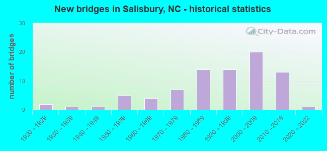
- New bridges - historical statistics
- 21920-1929
- 11930-1939
- 11940-1949
- 51950-1959
- 41960-1969
- 71970-1979
- 141980-1989
- 141990-1999
- 202000-2009
- 132010-2019
- 12020-2022
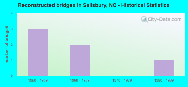
- Reconstructed bridges - Historical Statistics
- 31950-1959
- 21960-1969
- 01970-1979
- 11980-1989
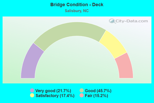
- Bridge Condition - Deck
- 21.7%Very good
- 45.7%Good
- 17.4%Satisfactory
- 15.2%Fair
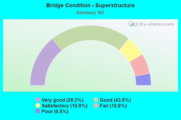
- Bridge Condition - Superstructure
- 28.3%Very good
- 43.5%Good
- 10.9%Satisfactory
- 10.9%Fair
- 6.5%Poor
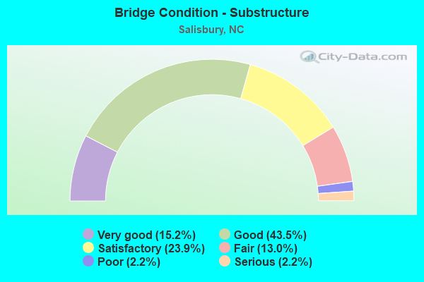
- Bridge Condition - Substructure
- 15.2%Very good
- 43.5%Good
- 23.9%Satisfactory
- 13.0%Fair
- 2.2%Poor
- 2.2%Serious
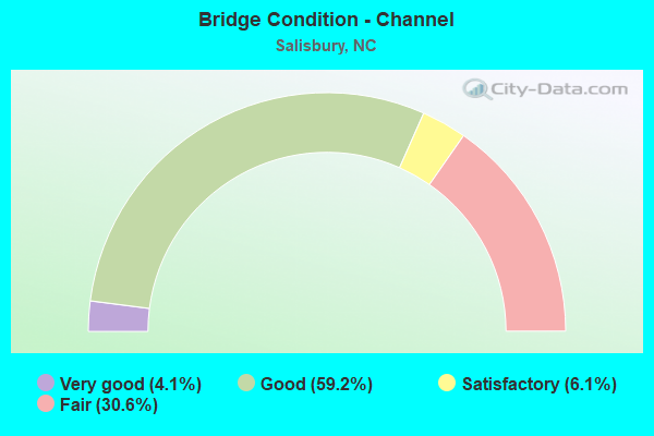
- Bridge Condition - Channel
- 4.1%Very good
- 59.2%Good
- 6.1%Satisfactory
- 30.6%Fair
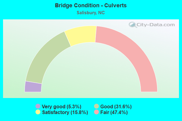
- Bridge Condition - Culverts
- 5.3%Very good
- 31.6%Good
- 15.8%Satisfactory
- 47.4%Fair
Find on map >> Show street view
Structure Number: 1590213, Location: 0.7 MI. N. JCT. SR1534 (Lat: 35.632039, Lng: -80.588586), Route carried "on" structure: State highway 1509, Year Built: 2008, Status: Open, Structure Length: 1.73m (5.68ft), Average Daily Traffic: 2,700 (year 2013), Truck Traffic: 7%, Average Future Daily Traffic: 5,400 (year 2040), Design Load: HS 20+Mod, Features Intersected: LITTLE CREEK
Minimum Vertical Clearance: 30+ m (98+ ft), Kilometerpoint: 0.000, Lanes on structure: 2, Owner: State Highway Agency, Approaching Roadway Width: 7.3m (24.0ft), Skew: 1 degrees, Material/Design: Prestressed concrete, Design/Construction: Slab, Number Of Spans In Main Unit: 1, Length of Maximum Span: 16.4m (53.8ft), Curb-To-Curb Width: 7.3m (24.0ft), Out-to-Out Width: 8.2m (26.9ft)
Condition: Deck: Good, Superstructure: Good, Substructure: Good, Channel: Good, Operating Rating: 70.7 metric tons, Method Used To Determine Operating Rating: Load Factor (LF), Inventory Rating: 41.7 metric tons, Method Used To Determine Inventory Rating: Load Factor (LF), Structural Evaluation: Better than present minimum criteria, Deck Geometry: High priority of replacement, Waterway Adequacy: Better than present minimum criteria, Approach Roadway Alignment: Equal to present desirable criteria, Designated Inspection Frequency: Every 24 months, Inspection Date: June 2020, Deck Structure Type: Concrete Precast Panels, Wearing Surface/Protective System: Wearing Surface: Bituminous
Find on map >> Show street view
Structure Number: 1590251, Location: 0.1 MI. E. JCT. SR1550 (Lat: 35.610631, Lng: -80.672192), Route carried "on" structure: State highway 1549, Year Built: 2018, Status: Open, Structure Length: 2.59m (8.50ft), Average Daily Traffic: 280 (year 2000), Truck Traffic: 6%, Average Future Daily Traffic: 560 (year 2040), Design Load: HL 93, Features Intersected: KERR CREEK
Minimum Vertical Clearance: 30+ m (98+ ft), Kilometerpoint: 0.000, Lanes on structure: 2, Owner: State Highway Agency, Approaching Roadway Width: 9.1m (29.9ft), Material/Design: Prestressed concrete, Design/Construction: Box Beam or Girders - Multiple, Number Of Spans In Main Unit: 1, Length of Maximum Span: 24.6m (80.7ft), Curb-To-Curb Width: 9.1m (29.9ft), Out-to-Out Width: 10.0m (32.8ft)
Condition: Deck: Very good, Superstructure: Very good, Substructure: Good, Channel: Good, Operating Rating: 83.4 metric tons, Method Used To Determine Operating Rating: Load and Resistance Factor (LRFR), Inventory Rating: 60.7 metric tons, Method Used To Determine Inventory Rating: Load and Resistance Factor (LRFR), Structural Evaluation: Better than present minimum criteria, Deck Geometry: Equal to present minimum criteria, Waterway Adequacy: Better than present minimum criteria, Approach Roadway Alignment: Equal to present desirable criteria, Designated Inspection Frequency: Every 24 months, Inspection Date: September 2020, Deck Structure Type: Concrete Precast Panels, Wearing Surface/Protective System: Wearing Surface: Bituminous
Find on map >> Show street view
Structure Number: 1590255, Location: 0.2 MI. W. JCT. SR1500 (Lat: 35.615056, Lng: -80.558414), Route carried "on" structure: State highway 1503, Year Built: 2021, Status: Open, Structure Length: 2.19m (7.19ft), Average Daily Traffic: 3,200 (year 2018), Truck Traffic: 7%, Average Future Daily Traffic: 6,400 (year 2040), Design Load: HL 93, Features Intersected: GRANTS CREEK
Minimum Vertical Clearance: 30+ m (98+ ft), Kilometerpoint: 0.000, Lanes on structure: 2, Owner: State Highway Agency, Approaching Roadway Width: 11.2m (36.7ft), Skew: 3 degrees, Material/Design: Prestressed concrete, Design/Construction: Slab, Number Of Spans In Main Unit: 1, Length of Maximum Span: 21.0m (68.9ft), Curb-To-Curb Width: 11.0m (36.1ft), Out-to-Out Width: 11.8m (38.7ft)
Condition: Deck: Very good, Superstructure: Very good, Substructure: Very good, Channel: Good, Operating Rating: 55.3 metric tons, Method Used To Determine Operating Rating: Load and Resistance Factor (LRFR), Inventory Rating: 42.6 metric tons, Method Used To Determine Inventory Rating: Load and Resistance Factor (LRFR), Structural Evaluation: Equal to present desirable criteria, Deck Geometry: Somewhat better than minimum adequacy, Waterway Adequacy: Better than present minimum criteria, Approach Roadway Alignment: Equal to present desirable criteria, Designated Inspection Frequency: Every 24 months, Inspection Date: November 2021, Deck Structure Type: Concrete Precast Panels, Wearing Surface/Protective System: Wearing Surface: Bituminous
Find on map >> Show street view
Structure Number: 1590272, Location: 0.2 MI. S. JCT. SR2254 (Lat: 35.648267, Lng: -80.433714), Route carried "on" structure: State highway 2126, Year Built: 1996, Status: Open, Structure Length: 0.79m (2.59ft), Average Daily Traffic: 760 (year 2013), Truck Traffic: 7%, Average Future Daily Traffic: 1,520 (year 2040), Design Load: HS 20+Mod, Features Intersected: BRANCH OF CRANE CREEK
Minimum Vertical Clearance: 30+ m (98+ ft), Kilometerpoint: 0.000, Lanes on structure: 2, Owner: State Highway Agency, Approaching Roadway Width: 6.0m (19.7ft), Material/Design: Steel, Design/Construction: Culvert, Number Of Spans In Main Unit: 2, Length of Maximum Span: 3.3m (10.8ft)
Condition: Channel: Fair, Culverts: Fair, Operating Rating: 89.8 metric tons, Method Used To Determine Operating Rating: Load and Resistance Factor (LRFR), Inventory Rating: 89.8 metric tons, Method Used To Determine Inventory Rating: Load and Resistance Factor (LRFR), Structural Evaluation: Somewhat better than minimum adequacy, Waterway Adequacy: Better than present minimum criteria, Approach Roadway Alignment: Equal to present desirable criteria, Designated Inspection Frequency: Every 24 months, Inspection Date: July 2020
Find on map >> Show street view
Structure Number: 1590278, Location: 0.2 MI. E. JCT. SR1710 (Lat: 35.674556, Lng: -80.502558), Route carried "on" structure: US 70, Year Built: 1994, Status: Open, Structure Length: 4.93m (16.17ft), Average Daily Traffic: 26,000 (year 2013), Truck Traffic: 12%, Average Future Daily Traffic: 52,000 (year 2040), Design Load: HS 20+Mod, Features Intersected: GRANTS CREEK
Minimum Vertical Clearance: 30+ m (98+ ft), Kilometerpoint: 0.000, Lanes on structure: 5, Base Highway Network: Yes (Inventory Route: 2, Subroute: 70), Owner: State Highway Agency, Approaching Roadway Width: 19.8m (65.0ft), Skew: 1 degrees, Material/Design: Prestressed concrete continuous, Design/Construction: Stringer/Multi-beam, Number Of Spans In Main Unit: 3, Length of Maximum Span: 19.2m (63.0ft), Curb or Sidewalk Widths: Left: 0.0m, Right: 1.2m (3.9ft), Curb-To-Curb Width: 19.5m (64.0ft), Out-to-Out Width: 21.5m (70.5ft)
Condition: Deck: Good, Superstructure: Good, Substructure: Good, Channel: Good, Operating Rating: 79.8 metric tons, Method Used To Determine Operating Rating: Load Factor (LF), Inventory Rating: 37.1 metric tons, Method Used To Determine Inventory Rating: Load Factor (LF), Structural Evaluation: Better than present minimum criteria, Deck Geometry: Meets minimum limits, Waterway Adequacy: Better than present minimum criteria, Approach Roadway Alignment: Equal to present desirable criteria, Designated Inspection Frequency: Every 24 months, Inspection Date: June 2020, Deck Structure Type: Concrete Cast-file-Place, Wearing Surface/Protective System: Wearing Surface: Monolithic Concrete, Deck Protection: Epoxy Coated Reinforcing
Find on map >> Show street view
Structure Number: 1590281, Location: 0.6 MI. W. JCT. US29 (Lat: 35.616139, Lng: -80.523017), Route carried "on" structure: State highway 2538, Year Built: 2016, Status: Open, Structure Length: 1.37m (4.49ft), Average Daily Traffic: 3,300 (year 2014), Truck Traffic: 7%, Average Future Daily Traffic: 6,600 (year 2040), Design Load: HL 93, Features Intersected: TOWN CREEK
Minimum Vertical Clearance: 30+ m (98+ ft), Kilometerpoint: 0.000, Lanes on structure: 2, Owner: State Highway Agency, Approaching Roadway Width: 10.3m (33.8ft), Skew: 1 degrees, Material/Design: Concrete continuous, Design/Construction: Culvert, Number Of Spans In Main Unit: 3, Length of Maximum Span: 4.2m (13.8ft)
Condition: Channel: Fair, Culverts: Very good, Operating Rating: 57.1 metric tons, Method Used To Determine Operating Rating: Load and Resistance Factor (LRFR), Inventory Rating: 43.5 metric tons, Method Used To Determine Inventory Rating: Load and Resistance Factor (LRFR), Structural Evaluation: Equal to present desirable criteria, Waterway Adequacy: Better than present minimum criteria, Approach Roadway Alignment: Equal to present desirable criteria, Designated Inspection Frequency: Every 24 months, Inspection Date: March 2021
Find on map >> Show street view
Structure Number: 1590301, Location: 0.2 MI. E. JCT. SR1006 (Lat: 35.622608, Lng: -80.458497), Route carried "on" structure: State highway 2312, Year Built: 2018, Status: Open, Structure Length: 2.13m (6.99ft), Average Daily Traffic: 360 (year 2015), Truck Traffic: 7%, Average Future Daily Traffic: 720 (year 2040), Design Load: HL 93, Features Intersected: CRANE CREEK
Minimum Vertical Clearance: 30+ m (98+ ft), Kilometerpoint: 0.000, Lanes on structure: 2, Owner: State Highway Agency, Approaching Roadway Width: 8.2m (26.9ft), Material/Design: Prestressed concrete, Design/Construction: Slab, Number Of Spans In Main Unit: 1, Length of Maximum Span: 20.4m (66.9ft), Curb-To-Curb Width: 8.2m (26.9ft), Out-to-Out Width: 9.1m (29.9ft)
Condition: Deck: Very good, Superstructure: Very good, Substructure: Very good, Channel: Good, Operating Rating: 56.2 metric tons, Method Used To Determine Operating Rating: Load and Resistance Factor (LRFR), Inventory Rating: 41.7 metric tons, Method Used To Determine Inventory Rating: Load and Resistance Factor (LRFR), Structural Evaluation: Equal to present desirable criteria, Deck Geometry: Somewhat better than minimum adequacy, Waterway Adequacy: Better than present minimum criteria, Approach Roadway Alignment: Equal to present desirable criteria, Designated Inspection Frequency: Every 24 months, Inspection Date: April 2020, Deck Structure Type: Concrete Precast Panels, Wearing Surface/Protective System: Wearing Surface: Bituminous
Find on map >> Show street view
Structure Number: 1590302, Location: 0.7 MI. S. JCT. SR1514 (Lat: 35.629553, Lng: -80.560894), Route carried "on" structure: State highway 1512, Year Built: 1983, Status: Open, Structure Length: 1.18m (3.87ft), Average Daily Traffic: 770 (year 1998), Truck Traffic: 7%, Average Future Daily Traffic: 1,540 (year 2040), Design Load: HS 20+Mod, Features Intersected: LITTLE CREEK
Minimum Vertical Clearance: 30+ m (98+ ft), Kilometerpoint: 0.000, Lanes on structure: 2, Owner: State Highway Agency, Approaching Roadway Width: 5.7m (18.7ft), Skew: 3 degrees, Material/Design: Steel, Design/Construction: Culvert, Number Of Spans In Main Unit: 3, Length of Maximum Span: 2.7m (8.9ft)
Condition: Channel: Good, Culverts: Fair, Operating Rating: 89.8 metric tons, Method Used To Determine Operating Rating: Load and Resistance Factor (LRFR), Inventory Rating: 89.8 metric tons, Method Used To Determine Inventory Rating: Load and Resistance Factor (LRFR), Structural Evaluation: Somewhat better than minimum adequacy, Waterway Adequacy: Better than present minimum criteria, Approach Roadway Alignment: Equal to present desirable criteria, Designated Inspection Frequency: Every 24 months, Inspection Date: July 2020
Find on map >> Show street view
Structure Number: 1590306, Location: 0.15 MI. N. JCT. SR1002 (Lat: 35.583722, Lng: -80.498533), Route carried "on" structure: State highway 2532, Year Built: 2015, Status: Open, Structure Length: 2.19m (7.19ft), Average Daily Traffic: 1,100 (year 2012), Truck Traffic: 6%, Average Future Daily Traffic: 2,200 (year 2025), Design Load: HL 93, Features Intersected: CRANE CREEK
Minimum Vertical Clearance: 30+ m (98+ ft), Kilometerpoint: 0.000, Lanes on structure: 2, Owner: State Highway Agency, Approaching Roadway Width: 8.8m (28.9ft), Material/Design: Prestressed concrete, Design/Construction: Slab, Number Of Spans In Main Unit: 1, Length of Maximum Span: 21.0m (68.9ft), Curb-To-Curb Width: 8.2m (26.9ft), Out-to-Out Width: 9.1m (29.9ft)
Condition: Deck: Very good, Superstructure: Very good, Substructure: Very good, Channel: Good, Operating Rating: 56.2 metric tons, Method Used To Determine Operating Rating: Load and Resistance Factor (LRFR), Inventory Rating: 41.7 metric tons, Method Used To Determine Inventory Rating: Load and Resistance Factor (LRFR), Structural Evaluation: Equal to present desirable criteria, Deck Geometry: Meets minimum limits, Waterway Adequacy: Better than present minimum criteria, Approach Roadway Alignment: Equal to present desirable criteria, Designated Inspection Frequency: Every 24 months, Inspection Date: Febuary 2022, Deck Structure Type: Concrete Precast Panels, Wearing Surface/Protective System: Wearing Surface: Bituminous
Find on map >> Show street view
Structure Number: 1590324, Location: 0.6 MI.W.JCT. SR1657 (Lat: 35.626022, Lng: -80.605250), Route carried "on" structure: State highway 1534, Year Built: 1979, Status: Open, Structure Length: 1.18m (3.87ft), Average Daily Traffic: 30 (year 2000), Average Future Daily Traffic: 60 (year 2040), Design Load: HS 20+Mod, Features Intersected: LITTLE CREEK
Minimum Vertical Clearance: 30+ m (98+ ft), Kilometerpoint: 0.000, Lanes on structure: 2, Owner: State Highway Agency, Approaching Roadway Width: 6.7m (22.0ft), Material/Design: Steel, Design/Construction: Culvert, Number Of Spans In Main Unit: 3, Length of Maximum Span: 3.3m (10.8ft)
Condition: Channel: Fair, Culverts: Fair, Operating Rating: 89.8 metric tons, Method Used To Determine Operating Rating: Load and Resistance Factor (LRFR), Inventory Rating: 89.8 metric tons, Method Used To Determine Inventory Rating: Load and Resistance Factor (LRFR), Structural Evaluation: Somewhat better than minimum adequacy, Waterway Adequacy: Better than present minimum criteria, Approach Roadway Alignment: Equal to present desirable criteria, Designated Inspection Frequency: Every 24 months, Inspection Date: September 2020
Find on map >> Show street view
Structure Number: 1590381, Location: 0.7 MI. N. JCT. I85 (Lat: 35.665617, Lng: -80.467814), Route carried "on" structure: State highway 2200, Year Built: 2005, Status: Open, Structure Length: 2.98m (9.78ft), Average Daily Traffic: 18,000 (year 2013), Truck Traffic: 6%, Average Future Daily Traffic: 36,000 (year 2040), Design Load: HS 20+Mod, Features Intersected: SOUTHERN RAILWAY
Minimum Vertical Clearance: 30+ m (98+ ft), Kilometerpoint: 0.000, Lanes on structure: 4, Owner: State Highway Agency, Approaching Roadway Width: 20.4m (66.9ft), Skew: 20 degrees, Material/Design: Steel, Design/Construction: Stringer/Multi-beam, Number Of Spans In Main Unit: 1, Length of Maximum Span: 28.6m (93.8ft), Curb or Sidewalk Widths: Left: 2.3m (7.5ft), Right: 2.3m (7.5ft), Curb-To-Curb Width: 19.5m (64.0ft), Out-to-Out Width: 25.1m (82.3ft)
Condition: Deck: Good, Superstructure: Good, Substructure: Good, Operating Rating: 89.8 metric tons, Method Used To Determine Operating Rating: Load Factor (LF), Inventory Rating: 73.4 metric tons, Method Used To Determine Inventory Rating: Load Factor (LF), Structural Evaluation: Better than present minimum criteria, Deck Geometry: Better than present minimum criteria, Underclear: High priority of corrective action, Approach Roadway Alignment: Equal to present desirable criteria, Designated Inspection Frequency: Every 24 months, Inspection Date: March 2020, Deck Structure Type: Concrete Cast-file-Place, Wearing Surface/Protective System: Wearing Surface: Monolithic Concrete, Deck Protection: Epoxy Coated Reinforcing
Find on map >> Show street view
Structure Number: 1590389, Location: 0.2 MI. N. JCT. I85 (Lat: 35.659231, Lng: -80.461036), Route carried "on" structure: State highway 2200, Year Built: 1929, Year Reconstructed: 1957, Status: Open, Structure Length: 1.58m (5.18ft), Average Daily Traffic: 26,000 (year 2015), Truck Traffic: 6%, Average Future Daily Traffic: 52,000 (year 2040), Design Load: HS 20, Features Intersected: TOWN CREEK
Minimum Vertical Clearance: 30+ m (98+ ft), Kilometerpoint: 0.000, Lanes on structure: 7, Owner: State Highway Agency, Approaching Roadway Width: 29.2m (95.8ft), Skew: 1 degrees, Material/Design: Concrete continuous, Design/Construction: Culvert, Number Of Spans In Main Unit: 4, Length of Maximum Span: 3.6m (11.8ft)
Condition: Channel: Good, Culverts: Satisfactory, Operating Rating: 41.7 metric tons, Method Used To Determine Operating Rating: Field evaluation and documented engineering judgment, Inventory Rating: 32.6 metric tons, Method Used To Determine Inventory Rating: Field evaluation and documented engineering judgment, Structural Evaluation: Equal to present minimum criteria, Waterway Adequacy: Better than present minimum criteria, Approach Roadway Alignment: Equal to present desirable criteria, Designated Inspection Frequency: Every 24 months, Underwater Inspection Frequency: Every 60 months, Inspection Date: March 2021, Underwater Inspection Date: March 2021
Find on map >> Show street view
Structure Number: 1590392, Location: 0.3 MI. S. JCT. I85 (Lat: 35.722544, Lng: -80.391744), Route carried "on" structure: US 29, Year Built: 2014, Status: Open, Structure Length: 26.60m (87.27ft), Average Daily Traffic: 2,600 (year 2018), Truck Traffic: 6%, Average Future Daily Traffic: 5,200 (year 2040), Design Load: HL 93, Features Intersected: YADKIN RIVER
Minimum Vertical Clearance: 30+ m (98+ ft), Kilometerpoint: 0.000, Lanes on structure: 2, Owner: State Highway Agency, Approaching Roadway Width: 8.2m (26.9ft), Skew: 10 degrees, Material/Design: Prestressed concrete continuous, Design/Construction: Stringer/Multi-beam, Number Of Spans In Main Unit: 6, Number Of Approach Spans: 1, Length of Maximum Span: 42.0m (137.8ft), Curb-To-Curb Width: 9.7m (31.8ft), Out-to-Out Width: 10.8m (35.4ft)
Condition: Deck: Good, Superstructure: Good, Substructure: Very good, Channel: Satisfactory, Operating Rating: 89.8 metric tons, Method Used To Determine Operating Rating: Load and Resistance Factor (LRFR), Inventory Rating: 66.2 metric tons, Method Used To Determine Inventory Rating: Load and Resistance Factor (LRFR), Structural Evaluation: Better than present minimum criteria, Deck Geometry: Meets minimum limits, Waterway Adequacy: Better than present minimum criteria, Approach Roadway Alignment: Equal to present desirable criteria, Designated Inspection Frequency: Every 24 months, Underwater Inspection Frequency: Every 60 months, Inspection Date: Febuary 2022, Underwater Inspection Date: March 2020, Deck Structure Type: Concrete Cast-file-Place, Wearing Surface/Protective System: Wearing Surface: Monolithic Concrete
Find on map >> Show street view
Structure Number: 1590393, Location: 0.3 MI.E.JCT.US70 (Lat: 35.673889, Lng: -80.470492), Route carried "on" structure: City street , Year Built: 1940, Status: Posted for load, Structure Length: 3.10m (10.17ft), Average Daily Traffic: 5,555 (year 1992), Truck Traffic: 7%, Average Future Daily Traffic: 11,110 (year 2040), Design Load: HS 20, Features Intersected: NORFOLK SOUTHERN RR., Facility Carried by Structure: NORTH ELLIS ST.
Minimum Vertical Clearance: 30+ m (98+ ft), Kilometerpoint: 0.000, Lanes on structure: 2, Owner: City or Municipal Highway Agency, Approaching Roadway Width: 7.3m (24.0ft), Skew: 1 degrees, Material/Design: Steel, Design/Construction: Stringer/Multi-beam, Number Of Spans In Main Unit: 1, Number Of Approach Spans: 4, Length of Maximum Span: 10.3m (33.8ft), Curb or Sidewalk Widths: Left: 1.4m (4.6ft), Right: 1.4m (4.6ft), Curb-To-Curb Width: 7.9m (25.9ft), Out-to-Out Width: 10.7m (35.1ft)
Condition: Deck: Good, Superstructure: Fair, Substructure: Fair, Operating Rating: 11.7 metric tons, Method Used To Determine Operating Rating: Allowable Stress (AS), Inventory Rating: 7.2 metric tons, Method Used To Determine Inventory Rating: Allowable Stress (AS), Structural Evaluation: High priority of corrective action, Deck Geometry: High priority of replacement, Underclear: High priority of corrective action, Approach Roadway Alignment: Equal to present desirable criteria, Bridge Posting: Required (Relationship of Operating Rating to Maximum Legal Load: > 39.9% below), Designated Inspection Frequency: Every 24 months, Inspection Date: January 2022, Deck Structure Type: Wood or Timber, Wearing Surface/Protective System: Wearing Surface: Bituminous
Find on map >> Show street view
Structure Number: 1590394, Location: .1MI.S.JCT.MAIN STREET (Lat: 35.663831, Lng: -80.470006), Route carried "on" structure: City street , Year Built: 1950, Status: Posted for load, Structure Length: 2.77m (9.09ft), Average Daily Traffic: 3,000 (year 1992), Truck Traffic: 7%, Average Future Daily Traffic: 6,000 (year 2025), Design Load: HS 20, Features Intersected: NORFOLK SOUTHERN RR, Facility Carried by Structure: EAST BANK STREET
Minimum Vertical Clearance: 30+ m (98+ ft), Kilometerpoint: 0.000, Lanes on structure: 2, Owner: City or Municipal Highway Agency, Approaching Roadway Width: 10.0m (32.8ft), Material/Design: Steel continuous, Design/Construction: Stringer/Multi-beam, Number Of Spans In Main Unit: 3, Length of Maximum Span: 11.8m (38.7ft), Curb or Sidewalk Widths: Left: 1.6m (5.2ft), Right: 1.6m (5.2ft), Curb-To-Curb Width: 10.0m (32.8ft), Out-to-Out Width: 14.1m (46.3ft)
Condition: Deck: Fair, Superstructure: Fair, Substructure: Satisfactory, Operating Rating: 29.0 metric tons, Method Used To Determine Operating Rating: Load Factor (LF), Inventory Rating: 16.3 metric tons, Method Used To Determine Inventory Rating: Load Factor (LF), Structural Evaluation: Meets minimum limits, Deck Geometry: Meets minimum limits, Underclear: Meets minimum limits, Approach Roadway Alignment: Equal to present desirable criteria, Bridge Posting: Required (Relationship of Operating Rating to Maximum Legal Load: 10.0 - 19.9% below), Designated Inspection Frequency: Every 24 months, Inspection Date: January 2022, Deck Structure Type: Concrete Cast-file-Place, Wearing Surface/Protective System: Wearing Surface: Monolithic Concrete
Find on map >> Show street view
Structure Number: 1590395, Location: 0.2 MI. S. JCT. SR2540 (Lat: 35.646733, Lng: -80.491225), Route carried "on" structure: US 601, Year Built: 1980, Status: Open, Structure Length: 1.76m (5.77ft), Average Daily Traffic: 31,000 (year 2013), Truck Traffic: 12%, Average Future Daily Traffic: 62,000 (year 2040), Design Load: HS 20+Mod, Features Intersected: TOWN CREEK
Minimum Vertical Clearance: 30+ m (98+ ft), Kilometerpoint: 0.000, Lanes on structure: 5, Base Highway Network: Yes (Inventory Route: 2, Subroute: 1), Owner: State Highway Agency, Approaching Roadway Width: 23.7m (77.8ft), Skew: 5 degrees, Material/Design: Concrete continuous, Design/Construction: Culvert, Number Of Spans In Main Unit: 3, Length of Maximum Span: 3.6m (11.8ft)
Condition: Channel: Fair, Culverts: Fair, Operating Rating: 58.0 metric tons, Method Used To Determine Operating Rating: Load and Resistance Factor (LRFR), Inventory Rating: 44.4 metric tons, Method Used To Determine Inventory Rating: Load and Resistance Factor (LRFR), Structural Evaluation: Somewhat better than minimum adequacy, Waterway Adequacy: Better than present minimum criteria, Approach Roadway Alignment: Equal to present desirable criteria, Designated Inspection Frequency: Every 24 months, Inspection Date: July 2020
Find on map >> Show street view
Structure Number: 1590396, Location: 0.3 MI. N. JCT. SR2541 (Lat: 35.644783, Lng: -80.486378), Route carried "on" structure: US 601, Year Built: 1980, Status: Open, Structure Length: 0.64m (2.10ft), Average Daily Traffic: 24,000 (year 2013), Truck Traffic: 12%, Average Future Daily Traffic: 48,000 (year 2040), Design Load: HS 20+Mod, Features Intersected: UT TO TOWN CREEK
Minimum Vertical Clearance: 30+ m (98+ ft), Kilometerpoint: 0.000, Lanes on structure: 5, Base Highway Network: Yes (Inventory Route: 2, Subroute: 1), Owner: State Highway Agency, Approaching Roadway Width: 22.2m (72.8ft), Skew: 21 degrees, Material/Design: Concrete continuous, Design/Construction: Culvert, Number Of Spans In Main Unit: 2, Length of Maximum Span: 3.0m (9.8ft)
Condition: Channel: Fair, Culverts: Good, Operating Rating: 48.0 metric tons, Method Used To Determine Operating Rating: Load and Resistance Factor (LRFR), Inventory Rating: 37.1 metric tons, Method Used To Determine Inventory Rating: Load and Resistance Factor (LRFR), Structural Evaluation: Better than present minimum criteria, Waterway Adequacy: Better than present minimum criteria, Approach Roadway Alignment: Equal to present desirable criteria, Designated Inspection Frequency: Every 24 months, Inspection Date: July 2020
Find on map >> Show street view
Structure Number: 15904, Location: 0.15 MI. W. JCT. SR2048 (Lat: 35.737606, Lng: -80.558475), Route carried "on" structure: State highway 1954, Year Built: 1995, Status: Open, Structure Length: 0.79m (2.59ft), Average Daily Traffic: 600 (year 2015), Truck Traffic: 6%, Average Future Daily Traffic: 1,200 (year 2040), Design Load: HS 20+Mod, Features Intersected: UT TO SECOND CREEK
Minimum Vertical Clearance: 30+ m (98+ ft), Kilometerpoint: 0.000, Lanes on structure: 2, Owner: State Highway Agency, Approaching Roadway Width: 6.7m (22.0ft), Material/Design: Steel, Design/Construction: Culvert, Number Of Spans In Main Unit: 2, Length of Maximum Span: 3.3m (10.8ft)
Condition: Channel: Fair, Culverts: Good, Operating Rating: 89.8 metric tons, Method Used To Determine Operating Rating: Load and Resistance Factor (LRFR), Inventory Rating: 89.8 metric tons, Method Used To Determine Inventory Rating: Load and Resistance Factor (LRFR), Structural Evaluation: Better than present minimum criteria, Waterway Adequacy: Better than present minimum criteria, Approach Roadway Alignment: Equal to present minimum criteria, Designated Inspection Frequency: Every 24 months, Inspection Date: Febuary 2022
Find on map >> Show street view
Structure Number: 1590402, Location: 1.0 MI. N. JCT. SR2140 (Lat: 35.555761, Lng: -80.329492), Route carried "on" structure: State highway 2365, Year Built: 1997, Status: Open, Structure Length: 0.67m (2.20ft), Average Daily Traffic: 60 (year 2000), Average Future Daily Traffic: 120 (year 2040), Design Load: HS 20+Mod, Features Intersected: REEDY CREEK
Minimum Vertical Clearance: 30+ m (98+ ft), Kilometerpoint: 0.000, Lanes on structure: 2, Owner: State Highway Agency, Approaching Roadway Width: 5.7m (18.7ft), Material/Design: Steel, Design/Construction: Culvert, Number Of Spans In Main Unit: 2, Length of Maximum Span: 2.7m (8.9ft)
Condition: Channel: Good, Culverts: Good, Operating Rating: 89.8 metric tons, Method Used To Determine Operating Rating: Load and Resistance Factor (LRFR), Inventory Rating: 89.8 metric tons, Method Used To Determine Inventory Rating: Load and Resistance Factor (LRFR), Structural Evaluation: Better than present minimum criteria, Waterway Adequacy: Better than present minimum criteria, Approach Roadway Alignment: Equal to present desirable criteria, Designated Inspection Frequency: Every 24 months, Inspection Date: September 2021
Find on map >> Show street view
Structure Number: 1590405, Location: 0.4 MI. W. JCT. NC150 (Lat: 35.669883, Lng: -80.529767), Route carried "on" structure: State highway 1526, Year Built: 1955, Status: Open, Structure Length: 0.76m (2.49ft), Average Daily Traffic: 8,500 (year 2014), Truck Traffic: 6%, Average Future Daily Traffic: 17,000 (year 2040), Design Load: HS 20+Mod, Features Intersected: DRAFT BRANCH
Minimum Vertical Clearance: 30+ m (98+ ft), Kilometerpoint: 0.000, Lanes on structure: 2, Owner: State Highway Agency, Approaching Roadway Width: 7.0m (23.0ft), Material/Design: Concrete continuous, Design/Construction: Culvert, Number Of Spans In Main Unit: 2, Length of Maximum Span: 3.6m (11.8ft)
Condition: Channel: Fair, Culverts: Satisfactory, Operating Rating: 41.7 metric tons, Method Used To Determine Operating Rating: Field evaluation and documented engineering judgment, Inventory Rating: 32.6 metric tons, Method Used To Determine Inventory Rating: Field evaluation and documented engineering judgment, Structural Evaluation: Equal to present minimum criteria, Waterway Adequacy: Better than present minimum criteria, Approach Roadway Alignment: Equal to present desirable criteria, Designated Inspection Frequency: Every 24 months, Inspection Date: July 2021
Find on map >> Show street view
Structure Number: 1590415, Location: .2 MI.W.JCT.INNES ST. (Lat: 35.658239, Lng: -80.463875), Route carried "on" structure: City street , Year Built: 2002, Status: Open, Structure Length: 9.14m (29.99ft), Average Daily Traffic: 1,000 (year 2002), Truck Traffic: 7%, Average Future Daily Traffic: 2,000 (year 2040), Design Load: HS 20, Features Intersected: TOWN CREEK, Facility Carried by Structure: ARLINGTON STREET
Minimum Vertical Clearance: 30+ m (98+ ft), Kilometerpoint: 0.000, Lanes on structure: 5, Owner: City or Municipal Highway Agency, Approaching Roadway Width: 19.5m (64.0ft), Skew: 23 degrees, Material/Design: Prestressed concrete continuous, Design/Construction: Stringer/Multi-beam, Number Of Spans In Main Unit: 3, Length of Maximum Span: 32.3m (106.0ft), Curb or Sidewalk Widths: Left: 1.6m (5.2ft), Right: 1.6m (5.2ft), Curb-To-Curb Width: 20.7m (67.9ft), Out-to-Out Width: 24.6m (80.7ft)
Condition: Deck: Satisfactory, Superstructure: Good, Substructure: Satisfactory, Channel: Good, Operating Rating: 66.2 metric tons, Method Used To Determine Operating Rating: Load Factor (LF), Inventory Rating: 39.0 metric tons, Method Used To Determine Inventory Rating: Load Factor (LF), Structural Evaluation: Equal to present minimum criteria, Deck Geometry: Somewhat better than minimum adequacy, Waterway Adequacy: Better than present minimum criteria, Approach Roadway Alignment: Equal to present desirable criteria, Designated Inspection Frequency: Every 24 months, Inspection Date: January 2022, Deck Structure Type: Concrete Cast-file-Place, Wearing Surface/Protective System: Wearing Surface: Monolithic Concrete
Find on map >> Show street view
Structure Number: 1590461, Location: .08 MI. N. OF JCT SR2662 (Lat: 35.623833, Lng: -80.527917), Route carried "on" structure: State highway 2538, Year Built: 2015, Status: Open, Structure Length: 12.52m (41.08ft), Average Daily Traffic: 3,300 (year 2016), Truck Traffic: 7%, Average Future Daily Traffic: 6,600 (year 2040), Design Load: HL 93, Features Intersected: NORFOLK S. RR&US29
Minimum Vertical Clearance: 30+ m (98+ ft), Kilometerpoint: 0.000, Lanes on structure: 2, Lanes under structure: 5, Owner: State Highway Agency, Approaching Roadway Width: 10.0m (32.8ft), Skew: 2 degrees, Material/Design: Prestressed concrete, Design/Construction: Stringer/Multi-beam, Number Of Spans In Main Unit: 4, Length of Maximum Span: 37.4m (122.7ft), Curb-To-Curb Width: 9.5m (31.2ft), Out-to-Out Width: 10.5m (34.4ft)
Condition: Deck: Good, Superstructure: Very good, Substructure: Good, Operating Rating: 89.8 metric tons, Method Used To Determine Operating Rating: Load and Resistance Factor (LRFR), Inventory Rating: 76.2 metric tons, Method Used To Determine Inventory Rating: Load and Resistance Factor (LRFR), Structural Evaluation: Better than present minimum criteria, Deck Geometry: Meets minimum limits, Underclear: Meets minimum limits, Approach Roadway Alignment: Equal to present desirable criteria, Designated Inspection Frequency: Every 24 months, Inspection Date: July 2021, Deck Structure Type: Concrete Cast-file-Place, Wearing Surface/Protective System: Wearing Surface: Monolithic Concrete
Find on map >> Show street view
Structure Number: 1590041, Location: 0.1 MI. N. JCT. SR1529 (Lat: 35.651522, Lng: -80.498694), Route carried "under" structure: US 70, Year Built: 1979, Structure Length: 0. m, Average Daily Traffic: 18,000 (year 2015), Truck Traffic: 12%, Features Intersected: US29/US70
Minimum Vertical Clearance: 5.25m (17.22ft), Kilometerpoint: 0.000, Lanes on structure: 4, Lanes under structure: 3, Material/Design: Steel, Design/Construction: Stringer/Multi-beam, Length of Maximum Span: 32.9m (107.9ft)
Find on map >> Show street view
Structure Number: 1590041, Location: 0.1 MI. N. JCT. SR1529 (Lat: 35.651522, Lng: -80.498694), Route carried "under" structure: US 70, Year Built: 1979, Structure Length: 0. m, Average Daily Traffic: 18,000 (year 2015), Truck Traffic: 12%, Features Intersected: US29/US70
Minimum Vertical Clearance: 5.76m (18.90ft), Kilometerpoint: 0.000, Lanes on structure: 4, Lanes under structure: 2, Material/Design: Steel, Design/Construction: Stringer/Multi-beam, Length of Maximum Span: 32.9m (107.9ft)
Find on map >> Show street view
Structure Number: 1590109, Location: 0.1 MI. W. JCT. SR2548 (Lat: 35.599564, Lng: -80.531431), Route carried "under" structure: Interstate 85, Year Built: 1999, Structure Length: 0. m, Average Daily Traffic: 41,500 (year 2015), Truck Traffic: 16%, Features Intersected: SR1500
Minimum Vertical Clearance: 5.89m (19.32ft), Kilometerpoint: 21.488, Lanes on structure: 4, Lanes under structure: 4, Material/Design: Steel continuous, Design/Construction: Stringer/Multi-beam, Length of Maximum Span: 41.4m (135.8ft)
Find on map >> Show street view
Structure Number: 1590109, Location: 0.1 MI. W. JCT. SR2548 (Lat: 35.599564, Lng: -80.531431), Route carried "under" structure: Interstate 85, Year Built: 1999, Structure Length: 0. m, Average Daily Traffic: 41,500 (year 2015), Truck Traffic: 16%, Features Intersected: SR1500
Minimum Vertical Clearance: 5.38m (17.65ft), Kilometerpoint: 21.488, Lanes on structure: 4, Lanes under structure: 4, Material/Design: Steel continuous, Design/Construction: Stringer/Multi-beam, Length of Maximum Span: 41.4m (135.8ft)
Find on map >> Show street view
Structure Number: 1590111, Location: 1.0 MI. E. JCT. US29 (Lat: 35.610911, Lng: -80.517972), Route carried "under" structure: Interstate 85, Year Built: 2000, Structure Length: 0. m, Average Daily Traffic: 46,500 (year 2019), Truck Traffic: 16%, Features Intersected: SR2538
Minimum Vertical Clearance: 5.44m (17.85ft), Kilometerpoint: 21.854, Lanes on structure: 4, Lanes under structure: 4, Material/Design: Steel continuous, Design/Construction: Stringer/Multi-beam, Length of Maximum Span: 37.7m (123.7ft)
Find on map >> Show street view
Structure Number: 1590111, Location: 1.0 MI. E. JCT. US29 (Lat: 35.610911, Lng: -80.517972), Route carried "under" structure: Interstate 85, Year Built: 2000, Structure Length: 0. m, Average Daily Traffic: 46,500 (year 2019), Truck Traffic: 16%, Features Intersected: SR2538
Minimum Vertical Clearance: 5.59m (18.34ft), Kilometerpoint: 21.854, Lanes on structure: 4, Lanes under structure: 4, Material/Design: Steel continuous, Design/Construction: Stringer/Multi-beam, Length of Maximum Span: 37.7m (123.7ft)
Find on map >> Show street view
Structure Number: 1590112, Location: 0.05 MI.E.JCT.SR1526 (Lat: 35.618844, Lng: -80.508444), Route carried "under" structure: Interstate 85, Year Built: 2000, Structure Length: 0. m, Average Daily Traffic: 42,500 (year 2015), Truck Traffic: 16%, Features Intersected: SR2539
Minimum Vertical Clearance: 5.30m (17.39ft), Kilometerpoint: 22.037, Lanes on structure: 2, Lanes under structure: 4, Material/Design: Steel continuous, Design/Construction: Stringer/Multi-beam, Length of Maximum Span: 38.1m (125.0ft)
Find on map >> Show street view
Structure Number: 1590112, Location: 0.05 MI.E.JCT.SR1526 (Lat: 35.618844, Lng: -80.508444), Route carried "under" structure: Interstate 85, Year Built: 2000, Structure Length: 0. m, Average Daily Traffic: 42,500 (year 2015), Truck Traffic: 16%, Features Intersected: SR2539
Minimum Vertical Clearance: 5.82m (19.09ft), Kilometerpoint: 22.037, Lanes on structure: 2, Lanes under structure: 4, Material/Design: Steel continuous, Design/Construction: Stringer/Multi-beam, Length of Maximum Span: 38.1m (125.0ft)
Find on map >> Show street view
Structure Number: 1590113, Location: 0.4 MI. E. JCT. SR2540 (Lat: 35.634419, Lng: -80.489747), Route carried "under" structure: Interstate 85, Year Built: 2000, Structure Length: 0. m, Average Daily Traffic: 33,500 (year 2013), Truck Traffic: 16%, Features Intersected: SR2528
Minimum Vertical Clearance: 5.32m (17.45ft), Kilometerpoint: 22.555, Lanes on structure: 4, Lanes under structure: 5, Material/Design: Steel continuous, Design/Construction: Stringer/Multi-beam, Length of Maximum Span: 39.6m (129.9ft)
Find on map >> Show street view
Structure Number: 1590113, Location: 0.4 MI. E. JCT. SR2540 (Lat: 35.634419, Lng: -80.489747), Route carried "under" structure: Interstate 85, Year Built: 2000, Structure Length: 0. m, Average Daily Traffic: 33,500 (year 2013), Truck Traffic: 16%, Features Intersected: SR2528
Minimum Vertical Clearance: 5.93m (19.46ft), Kilometerpoint: 22.555, Lanes on structure: 4, Lanes under structure: 5, Material/Design: Steel continuous, Design/Construction: Stringer/Multi-beam, Length of Maximum Span: 39.6m (129.9ft)
Find on map >> Show street view
Structure Number: 1590114, Location: 0.4 MI. W. JCT. SR1002 (Lat: 35.642414, Lng: -80.480458), Route carried "under" structure: Interstate 85, Year Built: 1980, Structure Length: 0. m, Average Daily Traffic: 34,000 (year 2013), Truck Traffic: 16%, Features Intersected: US601
Minimum Vertical Clearance: 5.66m (18.57ft), Kilometerpoint: 0.000, Lanes on structure: 4, Lanes under structure: 4, Material/Design: Steel, Design/Construction: Stringer/Multi-beam, Length of Maximum Span: 26.5m (86.9ft)
Find on map >> Show street view
Structure Number: 1590114, Location: 0.4 MI. W. JCT. SR1002 (Lat: 35.642414, Lng: -80.480458), Route carried "under" structure: Interstate 85, Year Built: 1980, Structure Length: 0. m, Average Daily Traffic: 34,000 (year 2013), Truck Traffic: 16%, Features Intersected: US601
Minimum Vertical Clearance: 6.02m (19.75ft), Kilometerpoint: 0.000, Lanes on structure: 4, Lanes under structure: 4, Material/Design: Steel, Design/Construction: Stringer/Multi-beam, Length of Maximum Span: 26.5m (86.9ft)
Find on map >> Show street view
Structure Number: 1590118, Location: 0.6 MI. N. JCT.SR1007 (Lat: 35.648286, Lng: -80.473136), Route carried "under" structure: State highway 1002, Year Built: 2005, Structure Length: 0. m, Average Daily Traffic: 9,900 (year 2013), Truck Traffic: 6%, Features Intersected: I85
Minimum Vertical Clearance: 4.90m (16.08ft), Kilometerpoint: 0.000, Lanes on structure: 10, Lanes under structure: 2, Material/Design: Steel, Design/Construction: Stringer/Multi-beam, Length of Maximum Span: 46.0m (150.9ft)
Find on map >> Show street view
Structure Number: 1590123, Location: 1.6 MI. N. JCT. SR1007 (Lat: 35.657547, Lng: -80.459406), Route carried "under" structure: US 52, Year Built: 2005, Structure Length: 0. m, Average Daily Traffic: 24,000 (year 2013), Truck Traffic: 12%, Features Intersected: I85
Minimum Vertical Clearance: 5.29m (17.36ft), Kilometerpoint: 0.000, Lanes on structure: 8, Lanes under structure: 6, Material/Design: Steel, Design/Construction: Stringer/Multi-beam, Length of Maximum Span: 74.6m (244.8ft)
Find on map >> Show street view
Structure Number: 1590127, Location: 0.11 MI. W. OF NEWSOME RD (Lat: 35.663878, Lng: -80.447436), Route carried "under" structure: Interstate 85, Year Built: 2003, Structure Length: 0. m, Average Daily Traffic: 32,500 (year 2013), Truck Traffic: 16%, Features Intersected: SR1002
Minimum Vertical Clearance: 5.27m (17.29ft), Kilometerpoint: 0.000, Lanes on structure: 2, Lanes under structure: 4, Material/Design: Steel continuous, Design/Construction: Stringer/Multi-beam, Length of Maximum Span: 31.6m (103.7ft)
Find on map >> Show street view
Structure Number: 1590127, Location: 0.11 MI. W. OF NEWSOME RD (Lat: 35.663878, Lng: -80.447436), Route carried "under" structure: Interstate 85, Year Built: 2003, Structure Length: 0. m, Average Daily Traffic: 32,500 (year 2013), Truck Traffic: 16%, Features Intersected: SR1002
Minimum Vertical Clearance: 5.67m (18.60ft), Kilometerpoint: 0.000, Lanes on structure: 2, Lanes under structure: 4, Material/Design: Steel continuous, Design/Construction: Stringer/Multi-beam, Length of Maximum Span: 31.6m (103.7ft)
Find on map >> Show street view
Structure Number: 1590461, Location: .08 MI. N. OF JCT SR2662 (Lat: 35.623833, Lng: -80.527917), Route carried "under" structure: US 29, Year Built: 2015, Structure Length: 0. m, Average Daily Traffic: 13,500 (year 2018), Truck Traffic: 12%, Features Intersected: SR2538
Minimum Vertical Clearance: 5.68m (18.64ft), Kilometerpoint: 0.000, Lanes on structure: 2, Lanes under structure: 5, Material/Design: Prestressed concrete, Design/Construction: Stringer/Multi-beam, Length of Maximum Span: 37.4m (122.7ft)