Bridge Statistics for Sand Springs, Oklahoma (OK)
Condition, Traffic, Stress, Structural Evaluation, Project Costs
- National Bridge Inventory (NBI) Statistics
- 92Number of bridges
- 1,198ft / 365mTotal length
- $105,052,000Total costs
- 610,019Total average daily traffic
- 70,852Total average daily truck traffic
- National Bridge Inventory (NBI) Registered Bridges for Sand Springs
- No street view available for this location
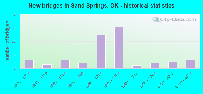
- New bridges - historical statistics
- 61920-1929
- 31930-1939
- 61940-1949
- 41950-1959
- 251960-1969
- 311970-1979
- 21980-1989
- 41990-1999
- 52000-2009
- 62010-2019
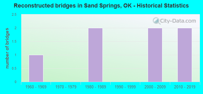
- Reconstructed bridges - Historical Statistics
- 11960-1969
- 01970-1979
- 21980-1989
- 01990-1999
- 22000-2009
- 22010-2019
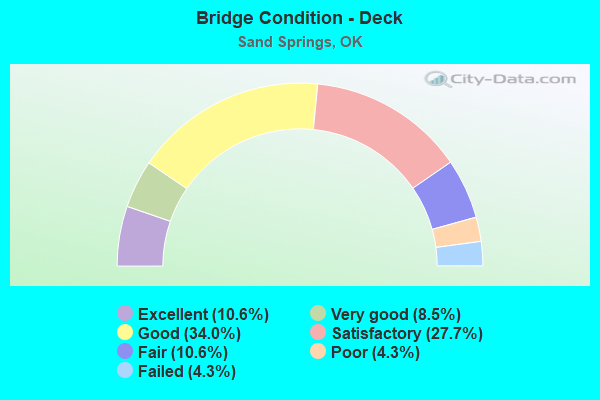
- Bridge Condition - Deck
- 10.6%Excellent
- 8.5%Very good
- 34.0%Good
- 27.7%Satisfactory
- 10.6%Fair
- 4.3%Poor
- 4.3%Failed
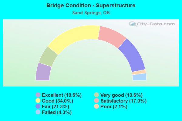
- Bridge Condition - Superstructure
- 10.6%Excellent
- 10.6%Very good
- 34.0%Good
- 17.0%Satisfactory
- 21.3%Fair
- 2.1%Poor
- 4.3%Failed
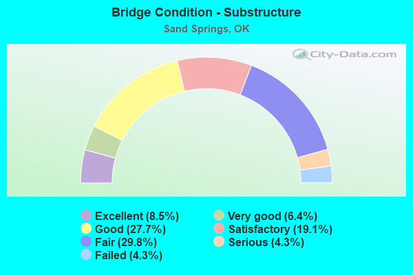
- Bridge Condition - Substructure
- 8.5%Excellent
- 6.4%Very good
- 27.7%Good
- 19.1%Satisfactory
- 29.8%Fair
- 4.3%Serious
- 4.3%Failed
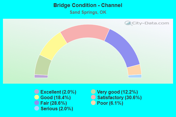
- Bridge Condition - Channel
- 2.0%Excellent
- 12.2%Very good
- 18.4%Good
- 30.6%Satisfactory
- 28.6%Fair
- 6.1%Poor
- 2.0%Serious
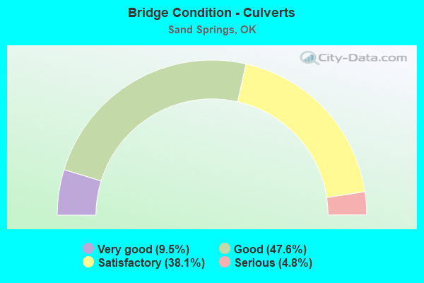
- Bridge Condition - Culverts
- 9.5%Very good
- 47.6%Good
- 38.1%Satisfactory
- 4.8%Serious
Find on map >> Show street view
Structure Number: 832, Location: INDUSTRIAL AVE S.OF 10TH (Lat: 36.147464, Lng: -96.119236), Route carried "on" structure: County highway N3870, Year Built: 1920, Status: Posted for load, Structure Length: 0.91m (2.99ft), Average Daily Traffic: 150 (year 2020), Truck Traffic: 10%, Average Future Daily Traffic: 240 (year 2040), Design Load: HS 20, Features Intersected: CREEK
Minimum Vertical Clearance: 30+ m (98+ ft), Kilometerpoint: 0.805, Lanes on structure: 1, Owner: County Highway Agency, Approaching Roadway Width: 3.7m (12.1ft), Skew: 1 degrees, Material/Design: Steel, Design/Construction: Stringer/Multi-beam, Number Of Spans In Main Unit: 1, Length of Maximum Span: 8.8m (28.9ft), Curb-To-Curb Width: 4.4m (14.4ft), Out-to-Out Width: 4.8m (15.7ft)
Condition: Deck: Good, Superstructure: Fair, Substructure: Fair, Channel: Fair, Operating Rating: 6.4 metric tons, Method Used To Determine Operating Rating: Load Factor (LF), Inventory Rating: 4.5 metric tons, Method Used To Determine Inventory Rating: Load Factor (LF), Structural Evaluation: High priority of replacement, Deck Geometry: High priority of replacement, Waterway Adequacy: Equal to present minimum criteria, Approach Roadway Alignment: Better than present minimum criteria, Bridge Posting: Required (Relationship of Operating Rating to Maximum Legal Load: > 39.9% below), Length Of Structure Improvement: 3.28m (10.76ft), Designated Inspection Frequency: Every 24 months, Inspection Date: October 2021, Bridge Improvement Cost: $84,000, Roadway Improvement Cost: $46,000, Total Project Cost: $225,000 ( Estimate for 2015), Deck Structure Type: Wood or Timber, Wearing Surface/Protective System: Wearing Surface: Wood or Timber
Find on map >> Show street view
Structure Number: 1289, Location: 0.5 MI E OF 177 ST W (Lat: 36.180578, Lng: -96.179689), Route carried "on" structure: City street 5710C, Year Built: 1922, Status: Posted for load, Structure Length: 23.04m (75.59ft), Average Daily Traffic: 400 (year 2020), Truck Traffic: 5%, Average Future Daily Traffic: 640 (year 2040), Features Intersected: SHELL CREEK LAKE
Minimum Vertical Clearance: 30+ m (98+ ft), Kilometerpoint: 1.287, Lanes on structure: 1, Owner: City or Municipal Highway Agency, Approaching Roadway Width: 4.9m (16.1ft), Material/Design: Concrete, Design/Construction: Slab, Number Of Spans In Main Unit: 42, Length of Maximum Span: 5.5m (18.0ft), Curb or Sidewalk Widths: Left: 0.4m (1.3ft), Right: 0.4m (1.3ft), Curb-To-Curb Width: 4.6m (15.1ft), Out-to-Out Width: 5.4m (17.7ft)
Condition: Deck: Poor, Superstructure: Fair, Substructure: Fair, Channel: Satisfactory, Operating Rating: 19.6 metric tons, Method Used To Determine Operating Rating: Load Factor (LF), Inventory Rating: 11.8 metric tons, Method Used To Determine Inventory Rating: Load Factor (LF), Structural Evaluation: Meets minimum limits, Deck Geometry: High priority of replacement, Waterway Adequacy: Somewhat better than minimum adequacy, Approach Roadway Alignment: High priority of replacement, Bridge Posting: Required (Relationship of Operating Rating to Maximum Legal Load: > 39.9% below), Length Of Structure Improvement: 25.35m (83.17ft), Designated Inspection Frequency: Every 24 months, Other Special Inspection Frequency: Every 24 months, Inspection Date: September 2021, Other Special Inspection Date: September 2020, Bridge Improvement Cost: $588,000, Roadway Improvement Cost: $324,000, Total Project Cost: $921,000 ( Estimate for 2015), Deck Structure Type: Concrete Cast-file-Place, Wearing Surface/Protective System: Wearing Surface: Monolithic Concrete
Find on map >> Show street view
Structure Number: 1421, Location: 4W 2.1N of KREMLIN (Lat: 36.582475, Lng: -97.908072), Route carried "on" structure: County highway N2860, Year Built: 1925, Status: Posted for load, Structure Length: 0.70m (2.30ft), Average Daily Traffic: 25 (year 2020), Truck Traffic: 10%, Average Future Daily Traffic: 40 (year 2040), Features Intersected: NINE MILE CREEK
Minimum Vertical Clearance: 30+ m (98+ ft), Kilometerpoint: 1.448, Lanes on structure: 2, Owner: County Highway Agency, Approaching Roadway Width: 5.5m (18.0ft), Material/Design: Concrete, Design/Construction: Stringer/Multi-beam, Number Of Spans In Main Unit: 1, Length of Maximum Span: 6.7m (22.0ft), Curb-To-Curb Width: 5.4m (17.7ft), Out-to-Out Width: 5.9m (19.4ft)
Condition: Deck: Poor, Superstructure: Poor, Substructure: Serious, Channel: Fair, Operating Rating: 11.8 metric tons, Method Used To Determine Operating Rating: Allowable Stress (AS), Inventory Rating: 6.4 metric tons, Method Used To Determine Inventory Rating: Allowable Stress (AS), Structural Evaluation: High priority of replacement, Deck Geometry: High priority of corrective action, Waterway Adequacy: Somewhat better than minimum adequacy, Approach Roadway Alignment: Equal to present desirable criteria, Bridge Posting: Required (Relationship of Operating Rating to Maximum Legal Load: 20.0 - 29.9% below), Length Of Structure Improvement: 2.86m (9.38ft), Designated Inspection Frequency: Every 6 months, Inspection Date: July 2021, Bridge Improvement Cost: $146,000, Roadway Improvement Cost: $80,000, Total Project Cost: $230,000 ( Estimate for 2015), Deck Structure Type: Concrete Cast-file-Place, Wearing Surface/Protective System: Wearing Surface: Gravel
Find on map >> Show street view
Structure Number: 143, Location: 2.5 S & 4 W OF LITTLE (Lat: 35.312694, Lng: -96.741575), Route carried "on" structure: County highway N3520, Year Built: 1925, Year Reconstructed: 1973, Status: Temporarily open, Structure Length: 0.61m (2.00ft), Average Daily Traffic: 75 (year 2020), Truck Traffic: 10%, Average Future Daily Traffic: 120 (year 2040), Design Load: HS 20, Features Intersected: CREEK
Minimum Vertical Clearance: 30+ m (98+ ft), Kilometerpoint: 0.805, Lanes on structure: 1, Owner: County Highway Agency, Approaching Roadway Width: 7.3m (24.0ft), Material/Design: Steel, Design/Construction: Stringer/Multi-beam, Number Of Spans In Main Unit: 1, Length of Maximum Span: 5.5m (18.0ft), Curb-To-Curb Width: 5.8m (19.0ft), Out-to-Out Width: 6.1m (20.0ft)
Condition: Deck: Failed, Superstructure: Failed, Substructure: Failed, Channel: Fair, Deck Geometry: Meets minimum limits, Waterway Adequacy: Somewhat better than minimum adequacy, Approach Roadway Alignment: Equal to present desirable criteria, Length Of Structure Improvement: 2.66m (8.73ft), Designated Inspection Frequency: Every 24 months, Inspection Date: July 2021, Bridge Improvement Cost: $136,000, Roadway Improvement Cost: $75,000, Total Project Cost: $225,000 ( Estimate for 2015), Deck Structure Type: Wood or Timber, Wearing Surface/Protective System: Wearing Surface: Gravel
Find on map >> Show street view
Structure Number: 1431, Location: 2.E 1.9S PF LAKE VALLE (Lat: 35.148383, Lng: -98.828206), Route carried "on" structure: County highway N2330, Year Built: 1925, Status: Open, Structure Length: 0.67m (2.20ft), Average Daily Traffic: 25 (year 2020), Truck Traffic: 10%, Average Future Daily Traffic: 40 (year 2040), Features Intersected: CREEK
Minimum Vertical Clearance: 30+ m (98+ ft), Kilometerpoint: 1.448, Lanes on structure: 2, Owner: County Highway Agency, Approaching Roadway Width: 5.5m (18.0ft), Material/Design: Concrete, Design/Construction: Tee Beam, Number Of Spans In Main Unit: 1, Length of Maximum Span: 6.1m (20.0ft), Curb-To-Curb Width: 5.1m (16.7ft), Out-to-Out Width: 5.6m (18.4ft)
Condition: Deck: Satisfactory, Superstructure: Satisfactory, Substructure: Satisfactory, Channel: Fair, Operating Rating: 37.2 metric tons, Method Used To Determine Operating Rating: Load Factor (LF), Inventory Rating: 27.2 metric tons, Method Used To Determine Inventory Rating: Load Factor (LF), Structural Evaluation: Equal to present minimum criteria, Deck Geometry: High priority of corrective action, Waterway Adequacy: Equal to present minimum criteria, Approach Roadway Alignment: Equal to present desirable criteria, Length Of Structure Improvement: 2.79m (9.15ft), Designated Inspection Frequency: Every 24 months, Inspection Date: January 2021, Bridge Improvement Cost: $143,000, Roadway Improvement Cost: $78,000, Total Project Cost: $225,000 ( Estimate for 2015), Deck Structure Type: Concrete Cast-file-Place, Wearing Surface/Protective System: Wearing Surface: Gravel
Find on map >> Show street view
Structure Number: 1441, Location: 1.4 S 9.3 W OF I-44 (Lat: 34.488506, Lng: -98.574833), Route carried "on" structure: County highway N2470, Year Built: 1925, Status: Open, Structure Length: 0.70m (2.30ft), Average Daily Traffic: 100 (year 2020), Truck Traffic: 10%, Average Future Daily Traffic: 160 (year 2040), Design Load: H 20, Features Intersected: CREEK
Minimum Vertical Clearance: 30+ m (98+ ft), Kilometerpoint: 0.644, Lanes on structure: 2, Owner: County Highway Agency, Approaching Roadway Width: 5.5m (18.0ft), Material/Design: Concrete, Design/Construction: Tee Beam, Number Of Spans In Main Unit: 1, Length of Maximum Span: 6.1m (20.0ft), Curb-To-Curb Width: 5.5m (18.0ft), Out-to-Out Width: 6.4m (21.0ft)
Condition: Deck: Satisfactory, Superstructure: Satisfactory, Substructure: Satisfactory, Channel: Satisfactory, Operating Rating: 37.6 metric tons, Method Used To Determine Operating Rating: Load Factor (LF), Inventory Rating: 22.5 metric tons, Method Used To Determine Inventory Rating: Load Factor (LF), Structural Evaluation: Equal to present minimum criteria, Deck Geometry: Meets minimum limits, Waterway Adequacy: Better than present minimum criteria, Approach Roadway Alignment: Equal to present desirable criteria, Length Of Structure Improvement: 2.86m (9.38ft), Designated Inspection Frequency: Every 24 months, Inspection Date: September 2021, Bridge Improvement Cost: $146,000, Roadway Improvement Cost: $80,000, Total Project Cost: $230,000 ( Estimate for 2015), Deck Structure Type: Concrete Cast-file-Place, Wearing Surface/Protective System: Wearing Surface: Gravel
Find on map >> Show street view
Structure Number: 2832, Location: WEKIWA RD .5E JCT 129 W (Lat: 36.139733, Lng: -96.124883), Route carried "on" structure: City street E0605, Year Built: 1930, Status: Open, Structure Length: 1.04m (3.41ft), Average Daily Traffic: 100 (year 2020), Truck Traffic: 10%, Average Future Daily Traffic: 160 (year 2040), Design Load: HS 20, Features Intersected: CREEK
Minimum Vertical Clearance: 30+ m (98+ ft), Kilometerpoint: 1.127, Lanes on structure: 2, Owner: City or Municipal Highway Agency, Approaching Roadway Width: 8.5m (27.9ft), Skew: 2 degrees, Material/Design: Concrete, Design/Construction: Culvert, Number Of Spans In Main Unit: 3, Length of Maximum Span: 3.0m (9.8ft)
Condition: Channel: Fair, Culverts: Good, Inventory Rating: 58.6 metric tons, Method Used To Determine Inventory Rating: Load Factor (LF), Structural Evaluation: Better than present minimum criteria, Waterway Adequacy: Somewhat better than minimum adequacy, Approach Roadway Alignment: Equal to present desirable criteria, Length Of Structure Improvement: 3.52m (11.55ft), Designated Inspection Frequency: Every 24 months, Inspection Date: September 2021, Bridge Improvement Cost: $100,000, Roadway Improvement Cost: $75,000, Total Project Cost: $225,000 ( Estimate for 2015), Deck Structure Type: Concrete Cast-file-Place
Find on map >> Show street view
Structure Number: 6442, Location: CHARLES PAGE BLVD W. 65TH (Lat: 36.146719, Lng: -96.067783), Route carried "on" structure: County highway E0602, Year Built: 1938, Status: Open, Structure Length: 1.65m (5.41ft), Average Daily Traffic: 6,200 (year 2020), Truck Traffic: 5%, Average Future Daily Traffic: 9,920 (year 2040), Design Load: HS 20, Features Intersected: BIGHEART CREEK
Minimum Vertical Clearance: 30+ m (98+ ft), Kilometerpoint: 0.966, Lanes on structure: 4, Owner: County Highway Agency, Approaching Roadway Width: 15.8m (51.8ft), Material/Design: Concrete, Design/Construction: Culvert, Number Of Spans In Main Unit: 5, Length of Maximum Span: 3.0m (9.8ft), Curb-To-Curb Width: 59.4m (194.9ft), Out-to-Out Width: 60.0m (196.9ft)
Condition: Channel: Satisfactory, Culverts: Satisfactory, Operating Rating: 49.9 metric tons, Method Used To Determine Operating Rating: Load Factor (LF), Inventory Rating: 29.9 metric tons, Method Used To Determine Inventory Rating: Load Factor (LF), Structural Evaluation: Equal to present minimum criteria, Deck Geometry: Superior to present desirable criteria, Waterway Adequacy: Better than present minimum criteria, Approach Roadway Alignment: Equal to present desirable criteria, Length Of Structure Improvement: 4.59m (15.06ft), Designated Inspection Frequency: Every 24 months, Inspection Date: October 2021, Bridge Improvement Cost: $100,000, Roadway Improvement Cost: $75,000, Total Project Cost: $225,000 ( Estimate for 2015), Deck Structure Type: Concrete Cast-file-Place, Wearing Surface/Protective System: Wearing Surface: Bituminous
Find on map >> Show street view
Structure Number: 6844, Location: 4.E KEYSTONE DAM (Lat: 36.149331, Lng: -96.193617), Route carried "on" structure: County highway E0600, Year Built: 1939, Status: Open, Structure Length: 0.64m (2.10ft), Average Daily Traffic: 452 (year 2020), Truck Traffic: 10%, Average Future Daily Traffic: 723 (year 2040), Design Load: HS 20, Features Intersected: CREEK
Minimum Vertical Clearance: 30+ m (98+ ft), Kilometerpoint: 1.287, Lanes on structure: 2, Owner: County Highway Agency, Approaching Roadway Width: 5.5m (18.0ft), Material/Design: Concrete, Design/Construction: Culvert, Number Of Spans In Main Unit: 2, Length of Maximum Span: 3.0m (9.8ft), Curb-To-Curb Width: 8.4m (27.6ft), Out-to-Out Width: 10.4m (34.1ft)
Condition: Channel: Satisfactory, Culverts: Satisfactory, Operating Rating: 42.6 metric tons, Method Used To Determine Operating Rating: Allowable Stress (AS), Inventory Rating: 32.7 metric tons, Method Used To Determine Inventory Rating: Allowable Stress (AS), Structural Evaluation: Equal to present minimum criteria, Deck Geometry: Somewhat better than minimum adequacy, Waterway Adequacy: Somewhat better than minimum adequacy, Approach Roadway Alignment: Equal to present minimum criteria, Length Of Structure Improvement: 2.86m (9.38ft), Designated Inspection Frequency: Every 24 months, Inspection Date: October 2021, Bridge Improvement Cost: $100,000, Roadway Improvement Cost: $75,000, Total Project Cost: $225,000 ( Estimate for 2015)
Find on map >> Show street view
Structure Number: 741, Location: OLD HWY 97 .5 MI S 41 ST (Lat: 36.097328, Lng: -96.119997), Route carried "on" structure: City street N3870, Year Built: 1940, Status: Posted for load, Structure Length: 0.83m (2.72ft), Average Daily Traffic: 100 (year 2020), Truck Traffic: 5%, Average Future Daily Traffic: 160 (year 2040), Design Load: HS 20, Features Intersected: CREEK
Minimum Vertical Clearance: 30+ m (98+ ft), Kilometerpoint: 0.805, Lanes on structure: 2, Owner: City or Municipal Highway Agency, Approaching Roadway Width: 6.9m (22.6ft), Material/Design: Steel, Design/Construction: Stringer/Multi-beam, Number Of Spans In Main Unit: 1, Length of Maximum Span: 7.7m (25.3ft), Curb-To-Curb Width: 6.9m (22.6ft), Out-to-Out Width: 7.0m (23.0ft)
Condition: Deck: Satisfactory, Superstructure: Satisfactory, Substructure: Good, Channel: Fair, Operating Rating: 31.8 metric tons, Method Used To Determine Operating Rating: Load Factor (LF), Inventory Rating: 19.1 metric tons, Method Used To Determine Inventory Rating: Load Factor (LF), Structural Evaluation: Somewhat better than minimum adequacy, Deck Geometry: Somewhat better than minimum adequacy, Waterway Adequacy: Somewhat better than minimum adequacy, Approach Roadway Alignment: Equal to present minimum criteria, Bridge Posting: Required (Relationship of Operating Rating to Maximum Legal Load: 0.1 - 9.9% below), Length Of Structure Improvement: 3.22m (10.56ft), Designated Inspection Frequency: Every 24 months, Inspection Date: September 2021, Bridge Improvement Cost: $165,000, Roadway Improvement Cost: $91,000, Total Project Cost: $261,000 ( Estimate for 2015), Deck Structure Type: Concrete Cast-file-Place, Wearing Surface/Protective System: Wearing Surface: Bituminous
Find on map >> Show street view
Structure Number: 8052, Location: OLD NORTH RD. .1W OF 81ST (Lat: 36.156694, Lng: -96.085444), Route carried "on" structure: County highway E0596, Year Built: 1940, Status: Open, Structure Length: 0.64m (2.10ft), Average Daily Traffic: 256 (year 2020), Truck Traffic: 10%, Average Future Daily Traffic: 410 (year 2040), Design Load: HS 20, Features Intersected: CREEK
Minimum Vertical Clearance: 30+ m (98+ ft), Kilometerpoint: 0.805, Lanes on structure: 2, Owner: County Highway Agency, Approaching Roadway Width: 6.9m (22.6ft), Material/Design: Concrete, Design/Construction: Culvert, Number Of Spans In Main Unit: 2, Length of Maximum Span: 3.0m (9.8ft), Curb-To-Curb Width: 18.0m (59.1ft), Out-to-Out Width: 18.6m (61.0ft)
Condition: Channel: Satisfactory, Culverts: Good, Operating Rating: 42.6 metric tons, Method Used To Determine Operating Rating: Load Factor (LF), Inventory Rating: 32.7 metric tons, Method Used To Determine Inventory Rating: Load Factor (LF), Structural Evaluation: Better than present minimum criteria, Deck Geometry: Superior to present desirable criteria, Waterway Adequacy: Equal to present minimum criteria, Approach Roadway Alignment: Better than present minimum criteria, Length Of Structure Improvement: 2.86m (9.38ft), Designated Inspection Frequency: Every 24 months, Inspection Date: October 2021, Bridge Improvement Cost: $100,000, Roadway Improvement Cost: $75,000, Total Project Cost: $225,000 ( Estimate for 2015)
Find on map >> Show street view
Structure Number: 8056, Location: 31ST .1E 65TH W AVE (Lat: 36.119303, Lng: -96.064328), Route carried "on" structure: County highway E0619, Year Built: 1940, Status: Posted for load, Structure Length: 0.76m (2.49ft), Average Daily Traffic: 1,895 (year 2020), Truck Traffic: 10%, Average Future Daily Traffic: 3,032 (year 2040), Design Load: HS 20, Features Intersected: CREEK
Minimum Vertical Clearance: 30+ m (98+ ft), Kilometerpoint: 0.161, Lanes on structure: 2, Owner: County Highway Agency, Approaching Roadway Width: 7.2m (23.6ft), Material/Design: Steel, Design/Construction: Stringer/Multi-beam, Number Of Spans In Main Unit: 1, Length of Maximum Span: 7.0m (23.0ft), Curb or Sidewalk Widths: Left: 0.0m, Right: 1.6m (5.2ft), Curb-To-Curb Width: 6.1m (20.0ft), Out-to-Out Width: 7.0m (23.0ft)
Condition: Deck: Good, Superstructure: Satisfactory, Substructure: Fair, Channel: Fair, Operating Rating: 42.6 metric tons, Method Used To Determine Operating Rating: Load Factor (LF), Inventory Rating: 25.4 metric tons, Method Used To Determine Inventory Rating: Load Factor (LF), Structural Evaluation: Somewhat better than minimum adequacy, Deck Geometry: High priority of replacement, Waterway Adequacy: Somewhat better than minimum adequacy, Approach Roadway Alignment: Equal to present minimum criteria, Bridge Posting: Required (Relationship of Operating Rating to Maximum Legal Load: 10.0 - 19.9% below), Length Of Structure Improvement: 3.22m (10.56ft), Designated Inspection Frequency: Every 24 months, Inspection Date: October 2021, Bridge Improvement Cost: $165,000, Roadway Improvement Cost: $91,000, Total Project Cost: $261,000 ( Estimate for 2015), Deck Structure Type: Concrete Cast-file-Place, Wearing Surface/Protective System: Wearing Surface: Bituminous
Find on map >> Show street view
Structure Number: 8658, Location: 56TH S. .3E 145TH W. AVE. (Lat: 36.082906, Lng: -96.148981), Route carried "on" structure: County highway E0645, Year Built: 1940, Status: Posted for load, Structure Length: 1.00m (3.28ft), Average Daily Traffic: 1,000 (year 2020), Truck Traffic: 10%, Average Future Daily Traffic: 1,600 (year 2040), Features Intersected: CREEK
Minimum Vertical Clearance: 30+ m (98+ ft), Kilometerpoint: 0.483, Lanes on structure: 2, Owner: County Highway Agency, Approaching Roadway Width: 6.0m (19.7ft), Material/Design: Steel, Design/Construction: Stringer/Multi-beam, Number Of Spans In Main Unit: 1, Length of Maximum Span: 9.1m (29.9ft), Curb-To-Curb Width: 6.0m (19.7ft), Out-to-Out Width: 6.8m (22.3ft)
Condition: Deck: Fair, Superstructure: Fair, Substructure: Fair, Channel: Fair, Operating Rating: 25.4 metric tons, Method Used To Determine Operating Rating: Allowable Stress (AS), Inventory Rating: 18.2 metric tons, Method Used To Determine Inventory Rating: Allowable Stress (AS), Structural Evaluation: Somewhat better than minimum adequacy, Deck Geometry: High priority of replacement, Waterway Adequacy: Somewhat better than minimum adequacy, Approach Roadway Alignment: Equal to present minimum criteria, Bridge Posting: Required (Relationship of Operating Rating to Maximum Legal Load: 20.0 - 29.9% below), Length Of Structure Improvement: 3.47m (11.38ft), Designated Inspection Frequency: Every 24 months, Inspection Date: October 2021, Bridge Improvement Cost: $177,000, Roadway Improvement Cost: $97,000, Total Project Cost: $281,000 ( Estimate for 2015), Deck Structure Type: Concrete Cast-file-Place, Wearing Surface/Protective System: Wearing Surface: Bituminous
Find on map >> Show street view
Structure Number: 10731, Location: 3.W JCT HWY 97 WEKIWA RD. (Lat: 36.153253, Lng: -96.170592), Route carried "on" structure: County highway E0600, Year Built: 1947, Year Reconstructed: 1985, Status: Open, Structure Length: 4.60m (15.09ft), Average Daily Traffic: 712 (year 2020), Truck Traffic: 10%, Average Future Daily Traffic: 1,139 (year 2040), Design Load: HS 20, Features Intersected: SHELL CREEK
Minimum Vertical Clearance: 30+ m (98+ ft), Kilometerpoint: 0.000, Lanes on structure: 2, Owner: County Highway Agency, Approaching Roadway Width: 6.6m (21.7ft), Material/Design: Concrete, Design/Construction: Stringer/Multi-beam, Number Of Spans In Main Unit: 4, Length of Maximum Span: 12.2m (40.0ft), Curb-To-Curb Width: 7.3m (24.0ft), Out-to-Out Width: 7.8m (25.6ft)
Condition: Deck: Satisfactory, Superstructure: Good, Substructure: Fair, Channel: Fair, Operating Rating: 24.5 metric tons, Method Used To Determine Operating Rating: Allowable Stress (AS), Inventory Rating: 14.5 metric tons, Method Used To Determine Inventory Rating: Allowable Stress (AS), Structural Evaluation: Meets minimum limits, Deck Geometry: Meets minimum limits, Waterway Adequacy: Somewhat better than minimum adequacy, Approach Roadway Alignment: Equal to present minimum criteria, Length Of Structure Improvement: 7.75m (25.43ft), Designated Inspection Frequency: Every 24 months, Inspection Date: October 2021, Bridge Improvement Cost: $396,000, Roadway Improvement Cost: $218,000, Total Project Cost: $675,000 ( Estimate for 2015), Deck Structure Type: Concrete Cast-file-Place, Wearing Surface/Protective System: Wearing Surface: Monolithic Concrete
Find on map >> Show street view
Structure Number: 11572, Location: AVERY DR 1.6 MI E SH 97 (Lat: 36.125367, Lng: -96.091489), Route carried "on" structure: County highway 8320, Year Built: 1950, Status: Open, Structure Length: 0.64m (2.10ft), Average Daily Traffic: 3,667 (year 2020), Truck Traffic: 5%, Average Future Daily Traffic: 5,867 (year 2040), Design Load: HS 20, Features Intersected: CREEK
Minimum Vertical Clearance: 30+ m (98+ ft), Kilometerpoint: 0.966, Lanes on structure: 2, Owner: County Highway Agency, Approaching Roadway Width: 9.1m (29.9ft), Material/Design: Concrete, Design/Construction: Culvert, Number Of Spans In Main Unit: 2, Length of Maximum Span: 3.0m (9.8ft), Curb-To-Curb Width: 18.6m (61.0ft), Out-to-Out Width: 19.2m (63.0ft)
Condition: Channel: Good, Culverts: Satisfactory, Operating Rating: 44.5 metric tons, Method Used To Determine Operating Rating: Allowable Stress (AS), Inventory Rating: 32.7 metric tons, Method Used To Determine Inventory Rating: Allowable Stress (AS), Structural Evaluation: Equal to present minimum criteria, Deck Geometry: Superior to present desirable criteria, Waterway Adequacy: Equal to present minimum criteria, Approach Roadway Alignment: Better than present minimum criteria, Length Of Structure Improvement: 2.72m (8.92ft), Designated Inspection Frequency: Every 24 months, Inspection Date: October 2021, Bridge Improvement Cost: $100,000, Roadway Improvement Cost: $75,000, Total Project Cost: $225,000 ( Estimate for 2015), Deck Structure Type: Concrete Cast-file-Place
Find on map >> Show street view
Structure Number: 12387, Location: OLD HWY 51 .7E 193RD WEST (Lat: 36.139447, Lng: -96.195331), Route carried "on" structure: County highway E0605, Year Built: 1950, Status: Open, Structure Length: 2.80m (9.19ft), Average Daily Traffic: 50 (year 2020), Truck Traffic: 10%, Average Future Daily Traffic: 80 (year 2040), Design Load: HS 20, Features Intersected: MUD CREEK
Minimum Vertical Clearance: 30+ m (98+ ft), Kilometerpoint: 0.805, Lanes on structure: 2, Owner: County Highway Agency, Approaching Roadway Width: 5.8m (19.0ft), Material/Design: Concrete, Design/Construction: Stringer/Multi-beam, Number Of Spans In Main Unit: 3, Length of Maximum Span: 9.1m (29.9ft), Curb-To-Curb Width: 6.7m (22.0ft), Out-to-Out Width: 7.6m (24.9ft)
Condition: Deck: Satisfactory, Superstructure: Fair, Substructure: Fair, Channel: Serious, Operating Rating: 42.6 metric tons, Method Used To Determine Operating Rating: Load Factor (LF), Inventory Rating: 32.7 metric tons, Method Used To Determine Inventory Rating: Load Factor (LF), Structural Evaluation: Somewhat better than minimum adequacy, Deck Geometry: Somewhat better than minimum adequacy, Waterway Adequacy: Somewhat better than minimum adequacy, Approach Roadway Alignment: Better than present minimum criteria, Length Of Structure Improvement: 5.96m (19.55ft), Designated Inspection Frequency: Every 24 months, Inspection Date: October 2021, Bridge Improvement Cost: $304,000, Roadway Improvement Cost: $167,000, Total Project Cost: $485,000 ( Estimate for 2015), Deck Structure Type: Concrete Cast-file-Place, Wearing Surface/Protective System: Wearing Surface: Bituminous
Find on map >> Show street view
Structure Number: 13584, Location: 1.6 S & .2 E OF DOLBERG (Lat: 34.605406, Lng: -96.915033), Route carried "on" structure: County highway N3420, Year Built: 1956, Year Reconstructed: 1993, Status: Temporarily open, Structure Length: 1.01m (3.31ft), Average Daily Traffic: 50 (year 2020), Truck Traffic: 10%, Average Future Daily Traffic: 80 (year 2040), Design Load: HS 20, Features Intersected: CREEK
Minimum Vertical Clearance: 30+ m (98+ ft), Kilometerpoint: 0.322, Lanes on structure: 1, Owner: County Highway Agency, Approaching Roadway Width: 6.1m (20.0ft), Material/Design: Wood or Timber, Design/Construction: Stringer/Multi-beam, Number Of Spans In Main Unit: 1, Length of Maximum Span: 9.4m (30.8ft), Curb-To-Curb Width: 4.9m (16.1ft), Out-to-Out Width: 4.9m (16.1ft)
Condition: Deck: Failed, Superstructure: Failed, Substructure: Failed, Channel: Satisfactory, Deck Geometry: High priority of corrective action, Waterway Adequacy: Somewhat better than minimum adequacy, Approach Roadway Alignment: High priority of corrective action, Length Of Structure Improvement: 3.47m (11.38ft), Designated Inspection Frequency: Every 24 months, Inspection Date: November 2020, Bridge Improvement Cost: $177,000, Roadway Improvement Cost: $97,000, Total Project Cost: $281,000 ( Estimate for 2015), Deck Structure Type: Wood or Timber, Wearing Surface/Protective System: Wearing Surface: Wood or Timber
Find on map >> Show street view
Structure Number: 1429, Location: 5.3 MI E JCT US77 (Lat: 34.187156, Lng: -97.060653), Route carried "on" structure: State highway 199, Year Built: 1959, Year Reconstructed: 2011, Status: Open, Structure Length: 1.01m (3.31ft), Average Daily Traffic: 6,000 (year 2020), Truck Traffic: 16%, Average Future Daily Traffic: 9,600 (year 2040), Design Load: HL 93, Features Intersected: CREEK
Minimum Vertical Clearance: 30+ m (98+ ft), Kilometerpoint: 8.802, Lanes on structure: 2, Base Highway Network: Yes, Owner: State Highway Agency, Approaching Roadway Width: 13.4m (44.0ft), Material/Design: Concrete, Design/Construction: Culvert, Number Of Spans In Main Unit: 3, Length of Maximum Span: 3.0m (9.8ft), Curb-To-Curb Width: 18.6m (61.0ft), Out-to-Out Width: 39.8m (130.6ft)
Condition: Channel: Satisfactory, Culverts: Good, Operating Rating: 90.7 metric tons, Method Used To Determine Operating Rating: Load and Resistance Factor (LRFR), Inventory Rating: 90.7 metric tons, Method Used To Determine Inventory Rating: Load and Resistance Factor (LRFR), Structural Evaluation: Better than present minimum criteria, Deck Geometry: Superior to present desirable criteria, Waterway Adequacy: Equal to present minimum criteria, Approach Roadway Alignment: Equal to present desirable criteria, Length Of Structure Improvement: 1.01m (3.31ft), Designated Inspection Frequency: Every 24 months, Inspection Date: October 2020, Bridge Improvement Cost: $230,000, Roadway Improvement Cost: $380,000, Total Project Cost: $644,000 ( Estimate for 2015)
Find on map >> Show street view
Structure Number: 14746, Location: 0.5 MI E OF 129 W AVE (Lat: 36.139183, Lng: -96.125631), Route carried "on" structure: City street E0607, Year Built: 1960, Year Reconstructed: 2010, Status: Open, Structure Length: 0.98m (3.22ft), Average Daily Traffic: 100 (year 2020), Truck Traffic: 10%, Average Future Daily Traffic: 160 (year 2040), Design Load: HS 20, Features Intersected: CREEK
Minimum Vertical Clearance: 30+ m (98+ ft), Kilometerpoint: 0.080, Lanes on structure: 3, Owner: City or Municipal Highway Agency, Approaching Roadway Width: 12.2m (40.0ft), Skew: 1 degrees, Material/Design: Concrete, Design/Construction: Culvert, Number Of Spans In Main Unit: 3, Length of Maximum Span: 3.0m (9.8ft), Curb or Sidewalk Widths: Left: 1.1m (3.6ft), Right: 4.4m (14.4ft), Curb-To-Curb Width: 12.5m (41.0ft), Out-to-Out Width: 18.7m (61.4ft)
Condition: Channel: Good, Culverts: Good, Operating Rating: 54.4 metric tons, Method Used To Determine Operating Rating: Load Factor (LF), Inventory Rating: 32.7 metric tons, Method Used To Determine Inventory Rating: Load Factor (LF), Structural Evaluation: Better than present minimum criteria, Deck Geometry: Meets minimum limits, Waterway Adequacy: Somewhat better than minimum adequacy, Approach Roadway Alignment: Equal to present desirable criteria, Length Of Structure Improvement: 3.52m (11.55ft), Designated Inspection Frequency: Every 24 months, Inspection Date: September 2021, Bridge Improvement Cost: $100,000, Roadway Improvement Cost: $75,000, Total Project Cost: $225,000 ( Estimate for 2015), Deck Structure Type: Concrete Cast-file-Place, Wearing Surface/Protective System: Wearing Surface: Bituminous
Find on map >> Show street view
Structure Number: 14748, Location: WHSP. CRK .1 MI S 41ST (Lat: 36.103872, Lng: -96.111325), Route carried "on" structure: City street N3870, Year Built: 1960, Status: Open, Structure Length: 1.04m (3.41ft), Average Daily Traffic: 128 (year 2020), Truck Traffic: 5%, Average Future Daily Traffic: 205 (year 2040), Features Intersected: WHISPERING CREEK, Facility Carried by Structure: N3874 (WHSP.CRK.DR
Minimum Vertical Clearance: 30+ m (98+ ft), Kilometerpoint: 0.805, Lanes on structure: 2, Owner: City or Municipal Highway Agency, Approaching Roadway Width: 11.6m (38.1ft), Material/Design: Concrete, Design/Construction: Culvert, Number Of Spans In Main Unit: 3, Length of Maximum Span: 3.0m (9.8ft), Curb or Sidewalk Widths: Left: 1.0m (3.3ft), Right: 1.0m (3.3ft), Curb-To-Curb Width: 11.6m (38.1ft), Out-to-Out Width: 14.9m (48.9ft)
Condition: Channel: Poor, Culverts: Satisfactory, Operating Rating: 32.7 metric tons, Method Used To Determine Operating Rating: Allowable Stress (AS), Inventory Rating: 19.6 metric tons, Method Used To Determine Inventory Rating: Allowable Stress (AS), Structural Evaluation: Somewhat better than minimum adequacy, Deck Geometry: Superior to present desirable criteria, Waterway Adequacy: Somewhat better than minimum adequacy, Approach Roadway Alignment: Better than present minimum criteria, Length Of Structure Improvement: 3.52m (11.55ft), Designated Inspection Frequency: Every 24 months, Inspection Date: September 2021, Bridge Improvement Cost: $100,000, Roadway Improvement Cost: $75,000, Total Project Cost: $225,000 ( Estimate for 2015), Deck Structure Type: Concrete Cast-file-Place, Wearing Surface/Protective System: Wearing Surface: Bituminous
Find on map >> Show street view
Structure Number: 16409, Location: 137TH W AVE .1S OF HWY 51 (Lat: 36.127572, Lng: -96.145989), Route carried "on" structure: County highway N3855, Year Built: 1965, Status: Open, Structure Length: 1.58m (5.18ft), Average Daily Traffic: 453 (year 2020), Truck Traffic: 10%, Average Future Daily Traffic: 725 (year 2040), Design Load: HS 20, Features Intersected: CREEK, Facility Carried by Structure: E3855(137TH.W.AVE
Minimum Vertical Clearance: 30+ m (98+ ft), Kilometerpoint: 0.644, Lanes on structure: 2, Owner: County Highway Agency, Approaching Roadway Width: 7.3m (24.0ft), Material/Design: Prestressed concrete, Design/Construction: Tee Beam, Number Of Spans In Main Unit: 1, Length of Maximum Span: 14.9m (48.9ft), Curb-To-Curb Width: 9.8m (32.2ft), Out-to-Out Width: 10.4m (34.1ft)
Condition: Deck: Good, Superstructure: Fair, Substructure: Satisfactory, Channel: Fair, Operating Rating: 42.6 metric tons, Method Used To Determine Operating Rating: Load Factor (LF), Inventory Rating: 32.7 metric tons, Method Used To Determine Inventory Rating: Load Factor (LF), Structural Evaluation: Somewhat better than minimum adequacy, Deck Geometry: Equal to present minimum criteria, Waterway Adequacy: Somewhat better than minimum adequacy, Approach Roadway Alignment: Equal to present desirable criteria, Length Of Structure Improvement: 4.40m (14.44ft), Designated Inspection Frequency: Every 24 months, Inspection Date: October 2021, Bridge Improvement Cost: $225,000, Roadway Improvement Cost: $124,000, Total Project Cost: $357,000 ( Estimate for 2015), Deck Structure Type: Concrete Cast-file-Place, Wearing Surface/Protective System: Wearing Surface: Bituminous
Find on map >> Show street view
Structure Number: 16871, Location: 7.5 MI SE C/L (Lat: 36.139736, Lng: -96.124886), Route carried "on" structure: ServiceUS 64, Year Built: 1967, Status: Open, Structure Length: 1.10m (3.61ft), Average Daily Traffic: 5,000 (year 2020), Truck Traffic: 8%, Average Future Daily Traffic: 8,000 (year 2040), Design Load: HS 20, Features Intersected: CREEK
Minimum Vertical Clearance: 30+ m (98+ ft), Kilometerpoint: 12.147, Lanes on structure: 2, Base Highway Network: Yes, Owner: State Highway Agency, Approaching Roadway Width: 8.5m (27.9ft), Skew: 2 degrees, Material/Design: Concrete, Design/Construction: Culvert, Number Of Spans In Main Unit: 3, Length of Maximum Span: 3.0m (9.8ft)
Condition: Channel: Good, Culverts: Very good, Operating Rating: 44.5 metric tons, Method Used To Determine Operating Rating: Allowable Stress (AS), Inventory Rating: 32.7 metric tons, Method Used To Determine Inventory Rating: Allowable Stress (AS), Structural Evaluation: Equal to present desirable criteria, Waterway Adequacy: Equal to present minimum criteria, Approach Roadway Alignment: Equal to present desirable criteria, Length Of Structure Improvement: 1.10m (3.61ft), Designated Inspection Frequency: Every 24 months, Inspection Date: October 2020, Bridge Improvement Cost: $230,000, Roadway Improvement Cost: $380,000, Total Project Cost: $644,000 ( Estimate for 2015)
Find on map >> Show street view
Structure Number: 16872, Location: 7.5 MI SE C/L (Lat: 36.139181, Lng: -96.125631), Route carried "on" structure: ServiceUS 64, Year Built: 1967, Year Reconstructed: 2010, Status: Open, Structure Length: 1.13m (3.71ft), Average Daily Traffic: 5,000 (year 2020), Truck Traffic: 8%, Average Future Daily Traffic: 8,000 (year 2040), Design Load: HS 20, Features Intersected: CREEK
Minimum Vertical Clearance: 30+ m (98+ ft), Kilometerpoint: 12.147, Lanes on structure: 3, Base Highway Network: Yes, Owner: State Highway Agency, Approaching Roadway Width: 13.4m (44.0ft), Skew: 3 degrees, Material/Design: Concrete, Design/Construction: Culvert, Number Of Spans In Main Unit: 3, Length of Maximum Span: 3.0m (9.8ft), Curb or Sidewalk Widths: Left: 0.9m (3.0ft), Right: 4.3m (14.1ft)
Condition: Channel: Good, Culverts: Very good, Operating Rating: 59.8 metric tons, Method Used To Determine Operating Rating: Load Factor (LF), Inventory Rating: 35.8 metric tons, Method Used To Determine Inventory Rating: Load Factor (LF), Structural Evaluation: Equal to present desirable criteria, Waterway Adequacy: Equal to present minimum criteria, Approach Roadway Alignment: Equal to present desirable criteria, Length Of Structure Improvement: 1.10m (3.61ft), Designated Inspection Frequency: Every 24 months, Inspection Date: October 2020, Bridge Improvement Cost: $230,000, Roadway Improvement Cost: $380,000, Total Project Cost: $644,000 ( Estimate for 2015)
Find on map >> Show street view
Structure Number: 16873, Location: 7.5 MI SE C/L (Lat: 36.139364, Lng: -96.125389), Route carried "on" structure: US 64, Year Built: 1967, Status: Open, Structure Length: 1.10m (3.61ft), Average Daily Traffic: 20,700 (year 2020), Truck Traffic: 8%, Average Future Daily Traffic: 33,120 (year 2040), Design Load: HS 20, Features Intersected: CREEK
Minimum Vertical Clearance: 30+ m (98+ ft), Kilometerpoint: 12.147, Lanes on structure: 4, Base Highway Network: Yes, Owner: State Highway Agency, Approaching Roadway Width: 12.2m (40.0ft), Skew: 2 degrees, Material/Design: Concrete, Design/Construction: Culvert, Number Of Spans In Main Unit: 3, Length of Maximum Span: 3.0m (9.8ft)
Condition: Channel: Good, Culverts: Good, Operating Rating: 44.5 metric tons, Method Used To Determine Operating Rating: Load Factor (LF), Inventory Rating: 32.7 metric tons, Method Used To Determine Inventory Rating: Load Factor (LF), Structural Evaluation: Better than present minimum criteria, Waterway Adequacy: Better than present minimum criteria, Approach Roadway Alignment: Equal to present desirable criteria, Length Of Structure Improvement: 1.10m (3.61ft), Designated Inspection Frequency: Every 24 months, Inspection Date: October 2020, Bridge Improvement Cost: $272,000, Roadway Improvement Cost: $448,000, Total Project Cost: $761,000 ( Estimate for 2015)
Find on map >> Show street view
Structure Number: 17196, Location: 0.5 MI E JCT SH 97 (Lat: 36.137631, Lng: -96.107664), Route carried "on" structure: US 64, Year Built: 1968, Status: Open, Structure Length: 2.77m (9.09ft), Average Daily Traffic: 25,350 (year 2020), Truck Traffic: 8%, Average Future Daily Traffic: 40,560 (year 2040), Design Load: HS 20, Features Intersected: LINCOLN AVE RAMP UNDER
Minimum Vertical Clearance: 30+ m (98+ ft), Kilometerpoint: 13.853, Lanes on structure: 2, Lanes under structure: 2, Base Highway Network: Yes, Owner: State Highway Agency, Approaching Roadway Width: 13.4m (44.0ft), Skew: 13 degrees, Material/Design: Steel, Design/Construction: Stringer/Multi-beam, Number Of Spans In Main Unit: 1, Length of Maximum Span: 27.1m (88.9ft), Curb-To-Curb Width: 11.3m (37.1ft), Out-to-Out Width: 12.2m (40.0ft)
Condition: Deck: Satisfactory, Superstructure: Good, Substructure: Satisfactory, Operating Rating: 58.2 metric tons, Method Used To Determine Operating Rating: Load Factor (LF), Inventory Rating: 34.9 metric tons, Method Used To Determine Inventory Rating: Load Factor (LF), Structural Evaluation: Equal to present minimum criteria, Deck Geometry: Somewhat better than minimum adequacy, Underclear: High priority of replacement, Approach Roadway Alignment: Equal to present desirable criteria, Length Of Structure Improvement: 3.52m (11.55ft), Designated Inspection Frequency: Every 24 months, Inspection Date: October 2020, Bridge Improvement Cost: $451,000, Roadway Improvement Cost: $745,000, Total Project Cost: $1,264,000 ( Estimate for 2015), Deck Structure Type: Concrete Cast-file-Place, Wearing Surface/Protective System: Wearing Surface: Bituminous
Find on map >> Show street view
Structure Number: 17197, Location: 0.5 MI E JCT SH 97 (Lat: 36.137372, Lng: -96.107392), Route carried "on" structure: US 64, Year Built: 1968, Status: Open, Structure Length: 2.77m (9.09ft), Average Daily Traffic: 13,000 (year 2020), Truck Traffic: 8%, Average Future Daily Traffic: 20,800 (year 2040), Design Load: HS 20, Features Intersected: LINCOLN AVE RAMP UNDER
Minimum Vertical Clearance: 30+ m (98+ ft), Kilometerpoint: 13.853, Lanes on structure: 2, Lanes under structure: 2, Base Highway Network: Yes, Owner: State Highway Agency, Approaching Roadway Width: 13.4m (44.0ft), Skew: 13 degrees, Material/Design: Steel, Design/Construction: Stringer/Multi-beam, Number Of Spans In Main Unit: 1, Length of Maximum Span: 27.1m (88.9ft), Curb-To-Curb Width: 11.3m (37.1ft), Out-to-Out Width: 12.2m (40.0ft)
Condition: Deck: Satisfactory, Superstructure: Good, Substructure: Good, Operating Rating: 58.2 metric tons, Method Used To Determine Operating Rating: Load Factor (LF), Inventory Rating: 34.9 metric tons, Method Used To Determine Inventory Rating: Load Factor (LF), Structural Evaluation: Better than present minimum criteria, Deck Geometry: Somewhat better than minimum adequacy, Underclear: High priority of replacement, Approach Roadway Alignment: Equal to present desirable criteria, Length Of Structure Improvement: 3.52m (11.55ft), Designated Inspection Frequency: Every 24 months, Inspection Date: October 2020, Bridge Improvement Cost: $451,000, Roadway Improvement Cost: $745,000, Total Project Cost: $1,264,000 ( Estimate for 2015), Deck Structure Type: Concrete Cast-file-Place, Wearing Surface/Protective System: Wearing Surface: Bituminous
Find on map >> Show street view
Structure Number: 17224, Location: 0.8 MI E JCT SH 97 (Lat: 36.138261, Lng: -96.101525), Route carried "on" structure: US 64, Year Built: 1968, Status: Open, Structure Length: 3.98m (13.06ft), Average Daily Traffic: 25,350 (year 2020), Truck Traffic: 8%, Average Future Daily Traffic: 40,560 (year 2040), Design Load: HL 93, Features Intersected: 97TH W AVE. UNDER
Minimum Vertical Clearance: 30+ m (98+ ft), Kilometerpoint: 23.176, Lanes on structure: 2, Lanes under structure: 4, Base Highway Network: Yes, Owner: State Highway Agency, Approaching Roadway Width: 15.8m (51.8ft), Skew: 10 degrees, Material/Design: Steel, Design/Construction: Stringer/Multi-beam, Number Of Spans In Main Unit: 3, Length of Maximum Span: 19.8m (65.0ft), Curb-To-Curb Width: 14.9m (48.9ft), Out-to-Out Width: 15.8m (51.8ft)
Condition: Deck: Excellent, Superstructure: Excellent, Substructure: Excellent, Operating Rating: 50.9 metric tons, Method Used To Determine Operating Rating: Load and Resistance Factor (LRFR), Inventory Rating: 39.3 metric tons, Method Used To Determine Inventory Rating: Load and Resistance Factor (LRFR), Structural Evaluation: Superior to present desirable criteria, Deck Geometry: Superior to present desirable criteria, Underclear: High priority of replacement, Approach Roadway Alignment: Equal to present desirable criteria, Length Of Structure Improvement: 6.03m (19.78ft), Designated Inspection Frequency: Every 24 months, Inspection Date: October 2020, Bridge Improvement Cost: $774,000, Roadway Improvement Cost: $1,277,000, Total Project Cost: $2,167,000 ( Estimate for 2015), Deck Structure Type: Concrete Cast-file-Place, Wearing Surface/Protective System: Wearing Surface: Monolithic Concrete, Membrane: Epoxy, Deck Protection: Epoxy Coated Reinforcing
Find on map >> Show street view
Structure Number: 17225, Location: 0.8 MI E JCT SH 97 (Lat: 36.137933, Lng: -96.101525), Route carried "on" structure: US 64, Year Built: 1968, Status: Open, Structure Length: 3.98m (13.06ft), Average Daily Traffic: 13,000 (year 2020), Truck Traffic: 8%, Average Future Daily Traffic: 20,800 (year 2040), Design Load: HL 93, Features Intersected: 97TH W AVE. UNDER
Minimum Vertical Clearance: 30+ m (98+ ft), Kilometerpoint: 23.176, Lanes on structure: 3, Lanes under structure: 4, Base Highway Network: Yes, Owner: State Highway Agency, Approaching Roadway Width: 15.8m (51.8ft), Skew: 10 degrees, Material/Design: Steel, Design/Construction: Stringer/Multi-beam, Number Of Spans In Main Unit: 3, Length of Maximum Span: 19.8m (65.0ft), Curb-To-Curb Width: 14.9m (48.9ft), Out-to-Out Width: 15.8m (51.8ft)
Condition: Deck: Excellent, Superstructure: Excellent, Substructure: Excellent, Operating Rating: 50.9 metric tons, Method Used To Determine Operating Rating: Load and Resistance Factor (LRFR), Inventory Rating: 39.3 metric tons, Method Used To Determine Inventory Rating: Load and Resistance Factor (LRFR), Structural Evaluation: Superior to present desirable criteria, Deck Geometry: Meets minimum limits, Underclear: High priority of replacement, Approach Roadway Alignment: Equal to present desirable criteria, Length Of Structure Improvement: 6.03m (19.78ft), Designated Inspection Frequency: Every 24 months, Inspection Date: October 2020, Bridge Improvement Cost: $1,084,000, Roadway Improvement Cost: $1,788,000, Total Project Cost: $3,034,000 ( Estimate for 2015), Deck Structure Type: Concrete Cast-file-Place, Wearing Surface/Protective System: Wearing Surface: Monolithic Concrete, Membrane: Epoxy, Deck Protection: Epoxy Coated Reinforcing
Find on map >> Show street view
Structure Number: 17233, Location: 8.1 MI SE C/L (Lat: 36.136550, Lng: -96.115539), Route carried "on" structure: US 64, Year Built: 1968, Status: Open, Structure Length: 4.24m (13.91ft), Average Daily Traffic: 10,350 (year 2020), Truck Traffic: 8%, Average Future Daily Traffic: 16,560 (year 2040), Design Load: HS 20, Features Intersected: S.H. 97 UNDER
Minimum Vertical Clearance: 30+ m (98+ ft), Kilometerpoint: 13.113, Lanes on structure: 2, Lanes under structure: 5, Base Highway Network: Yes, Owner: State Highway Agency, Approaching Roadway Width: 12.2m (40.0ft), Skew: 10 degrees, Material/Design: Steel continuous, Design/Construction: Stringer/Multi-beam, Number Of Spans In Main Unit: 2, Length of Maximum Span: 22.6m (74.1ft), Curb-To-Curb Width: 11.3m (37.1ft), Out-to-Out Width: 12.2m (40.0ft)
Condition: Deck: Satisfactory, Superstructure: Good, Substructure: Good, Operating Rating: 40.6 metric tons, Method Used To Determine Operating Rating: Load Factor (LF), Inventory Rating: 24.4 metric tons, Method Used To Determine Inventory Rating: Load Factor (LF), Structural Evaluation: Equal to present minimum criteria, Deck Geometry: Somewhat better than minimum adequacy, Underclear: High priority of replacement, Approach Roadway Alignment: Equal to present desirable criteria, Length Of Structure Improvement: 6.20m (20.34ft), Designated Inspection Frequency: Every 24 months, Inspection Date: October 2020, Bridge Improvement Cost: $795,000, Roadway Improvement Cost: $1,312,000, Total Project Cost: $2,227,000 ( Estimate for 2015), Deck Structure Type: Concrete Cast-file-Place, Wearing Surface/Protective System: Wearing Surface: Monolithic Concrete
Find on map >> Show street view
Structure Number: 17234, Location: 8.1 MI SE C/L (Lat: 36.136844, Lng: -96.115542), Route carried "on" structure: US 64, Year Built: 1968, Status: Open, Structure Length: 4.24m (13.91ft), Average Daily Traffic: 15,900 (year 2020), Truck Traffic: 8%, Average Future Daily Traffic: 25,440 (year 2040), Design Load: HS 20, Features Intersected: S.H. 97 UNDER
Minimum Vertical Clearance: 30+ m (98+ ft), Kilometerpoint: 13.113, Lanes on structure: 2, Lanes under structure: 5, Base Highway Network: Yes, Owner: State Highway Agency, Approaching Roadway Width: 12.2m (40.0ft), Skew: 10 degrees, Material/Design: Steel continuous, Design/Construction: Stringer/Multi-beam, Number Of Spans In Main Unit: 2, Length of Maximum Span: 22.6m (74.1ft), Curb-To-Curb Width: 11.3m (37.1ft), Out-to-Out Width: 12.2m (40.0ft)
Condition: Deck: Satisfactory, Superstructure: Good, Substructure: Good, Operating Rating: 40.6 metric tons, Method Used To Determine Operating Rating: Load Factor (LF), Inventory Rating: 24.4 metric tons, Method Used To Determine Inventory Rating: Load Factor (LF), Structural Evaluation: Equal to present minimum criteria, Deck Geometry: Somewhat better than minimum adequacy, Underclear: High priority of replacement, Approach Roadway Alignment: Equal to present desirable criteria, Length Of Structure Improvement: 6.20m (20.34ft), Designated Inspection Frequency: Every 24 months, Inspection Date: October 2020, Bridge Improvement Cost: $795,000, Roadway Improvement Cost: $1,312,000, Total Project Cost: $2,227,000 ( Estimate for 2015), Deck Structure Type: Concrete Cast-file-Place, Wearing Surface/Protective System: Wearing Surface: Monolithic Concrete
Find on map >> Show street view
Structure Number: 17235, Location: 0.3 MI E JCT SH 97 (Lat: 36.137175, Lng: -96.110461), Route carried "on" structure: US 64, Year Built: 1968, Status: Open, Structure Length: 4.21m (13.81ft), Average Daily Traffic: 25,350 (year 2020), Truck Traffic: 8%, Average Future Daily Traffic: 40,560 (year 2040), Design Load: HS 20, Features Intersected: MAIN ST. UNDER
Minimum Vertical Clearance: 30+ m (98+ ft), Kilometerpoint: 13.580, Lanes on structure: 2, Lanes under structure: 2, Base Highway Network: Yes, Owner: State Highway Agency, Approaching Roadway Width: 12.2m (40.0ft), Skew: 11 degrees, Material/Design: Steel, Design/Construction: Stringer/Multi-beam, Number Of Spans In Main Unit: 3, Length of Maximum Span: 22.6m (74.1ft), Curb-To-Curb Width: 11.3m (37.1ft), Out-to-Out Width: 12.2m (40.0ft)
Condition: Deck: Satisfactory, Superstructure: Good, Substructure: Good, Operating Rating: 74.0 metric tons, Method Used To Determine Operating Rating: Load Factor (LF), Inventory Rating: 44.5 metric tons, Method Used To Determine Inventory Rating: Load Factor (LF), Structural Evaluation: Better than present minimum criteria, Deck Geometry: Somewhat better than minimum adequacy, Underclear: High priority of replacement, Approach Roadway Alignment: Equal to present desirable criteria, Length Of Structure Improvement: 5.89m (19.32ft), Designated Inspection Frequency: Every 24 months, Inspection Date: October 2020, Bridge Improvement Cost: $755,000, Roadway Improvement Cost: $1,247,000, Total Project Cost: $2,115,000 ( Estimate for 2015), Deck Structure Type: Concrete Cast-file-Place, Wearing Surface/Protective System: Wearing Surface: Bituminous
Find on map >> Show street view
Structure Number: 17236, Location: 0.3 MI E JCT SH 97 (Lat: 36.136847, Lng: -96.110458), Route carried "on" structure: US 64, Year Built: 1968, Status: Open, Structure Length: 4.21m (13.81ft), Average Daily Traffic: 13,000 (year 2020), Truck Traffic: 8%, Average Future Daily Traffic: 20,800 (year 2040), Design Load: HS 20, Features Intersected: MAIN ST. UNDER
Minimum Vertical Clearance: 30+ m (98+ ft), Kilometerpoint: 13.580, Lanes on structure: 3, Lanes under structure: 2, Base Highway Network: Yes, Owner: State Highway Agency, Approaching Roadway Width: 16.5m (54.1ft), Skew: 10 degrees, Material/Design: Steel, Design/Construction: Stringer/Multi-beam, Number Of Spans In Main Unit: 3, Length of Maximum Span: 22.6m (74.1ft), Curb-To-Curb Width: 14.0m (45.9ft), Out-to-Out Width: 14.9m (48.9ft)
Condition: Deck: Satisfactory, Superstructure: Good, Substructure: Satisfactory, Operating Rating: 71.7 metric tons, Method Used To Determine Operating Rating: Load Factor (LF), Inventory Rating: 43.0 metric tons, Method Used To Determine Inventory Rating: Load Factor (LF), Structural Evaluation: Equal to present minimum criteria, Deck Geometry: Meets minimum limits, Underclear: High priority of replacement, Approach Roadway Alignment: Equal to present desirable criteria, Length Of Structure Improvement: 5.89m (19.32ft), Designated Inspection Frequency: Every 24 months, Inspection Date: October 2020, Bridge Improvement Cost: $1,058,000, Roadway Improvement Cost: $1,745,000, Total Project Cost: $2,962,000 ( Estimate for 2015), Deck Structure Type: Concrete Cast-file-Place, Wearing Surface/Protective System: Wearing Surface: Bituminous
Find on map >> Show street view
Structure Number: 17277, Location: 6.9 MI SE C/L (Lat: 36.141667, Lng: -96.135000), Route carried "on" structure: City street , Year Built: 1968, Status: Open, Structure Length: 5.03m (16.50ft), Average Daily Traffic: 1,000 (year 2020), Truck Traffic: 5%, Average Future Daily Traffic: 1,600 (year 2040), Design Load: HS 20, Features Intersected: U.S. 64 UNDER, Facility Carried by Structure: 129TH W. AVE.
Minimum Vertical Clearance: 30+ m (98+ ft), Kilometerpoint: 11.248, Lanes on structure: 2, Lanes under structure: 4, Owner: State Highway Agency, Approaching Roadway Width: 13.1m (43.0ft), Material/Design: Steel continuous, Design/Construction: Stringer/Multi-beam, Number Of Spans In Main Unit: 2, Length of Maximum Span: 25.9m (85.0ft), Curb-To-Curb Width: 13.1m (43.0ft), Out-to-Out Width: 13.7m (44.9ft)
Condition: Deck: Good, Superstructure: Satisfactory, Substructure: Satisfactory, Operating Rating: 59.6 metric tons, Method Used To Determine Operating Rating: Load Factor (LF), Inventory Rating: 35.7 metric tons, Method Used To Determine Inventory Rating: Load Factor (LF), Structural Evaluation: Equal to present minimum criteria, Deck Geometry: Superior to present desirable criteria, Underclear: Meets minimum limits, Approach Roadway Alignment: Equal to present desirable criteria, Length Of Structure Improvement: 7.20m (23.62ft), Designated Inspection Frequency: Every 24 months, Inspection Date: October 2020, Bridge Improvement Cost: $924,000, Roadway Improvement Cost: $1,524,000, Total Project Cost: $2,586,000 ( Estimate for 2015), Deck Structure Type: Concrete Cast-file-Place, Wearing Surface/Protective System: Wearing Surface: Monolithic Concrete
Find on map >> Show street view
Structure Number: 17751, Location: AVERY DR. .3 MI E SH 97 (Lat: 36.120867, Lng: -96.110506), Route carried "on" structure: County highway 7240, Year Built: 1970, Status: Open, Structure Length: 0.98m (3.22ft), Average Daily Traffic: 3,667 (year 2020), Truck Traffic: 15%, Average Future Daily Traffic: 5,867 (year 2040), Design Load: HS 20, Features Intersected: CREEK
Minimum Vertical Clearance: 30+ m (98+ ft), Kilometerpoint: 0.483, Lanes on structure: 2, Owner: County Highway Agency, Approaching Roadway Width: 9.8m (32.2ft), Material/Design: Concrete, Design/Construction: Culvert, Number Of Spans In Main Unit: 3, Length of Maximum Span: 3.0m (9.8ft), Curb-To-Curb Width: 14.9m (48.9ft), Out-to-Out Width: 15.5m (50.9ft)
Condition: Channel: Fair, Culverts: Serious, Operating Rating: 44.5 metric tons, Method Used To Determine Operating Rating: Allowable Stress (AS), Inventory Rating: 32.7 metric tons, Method Used To Determine Inventory Rating: Allowable Stress (AS), Structural Evaluation: High priority of corrective action, Deck Geometry: Superior to present desirable criteria, Waterway Adequacy: Somewhat better than minimum adequacy, Approach Roadway Alignment: Better than present minimum criteria, Length Of Structure Improvement: 3.52m (11.55ft), Designated Inspection Frequency: Every 12 months, Inspection Date: October 2021, Bridge Improvement Cost: $100,000, Roadway Improvement Cost: $75,000, Total Project Cost: $225,000 ( Estimate for 2015)
Find on map >> Show street view
Structure Number: 17987, Location: 1.9 MI SE C/L (Lat: 36.151361, Lng: -96.220731), Route carried "on" structure: US 64, Year Built: 1971, Status: Open, Structure Length: 1.01m (3.31ft), Average Daily Traffic: 20,700 (year 2020), Truck Traffic: 25%, Average Future Daily Traffic: 33,120 (year 2040), Design Load: HS 20, Features Intersected: CREEK
Minimum Vertical Clearance: 30+ m (98+ ft), Kilometerpoint: 3.121, Lanes on structure: 4, Base Highway Network: Yes, Owner: State Highway Agency, Approaching Roadway Width: 9.8m (32.2ft), Material/Design: Concrete, Design/Construction: Culvert, Number Of Spans In Main Unit: 3, Length of Maximum Span: 3.0m (9.8ft)
Condition: Channel: Very good, Culverts: Satisfactory, Operating Rating: 48.3 metric tons, Method Used To Determine Operating Rating: Load Factor (LF), Inventory Rating: 28.9 metric tons, Method Used To Determine Inventory Rating: Load Factor (LF), Structural Evaluation: Equal to present minimum criteria, Waterway Adequacy: Somewhat better than minimum adequacy, Approach Roadway Alignment: Equal to present desirable criteria, Length Of Structure Improvement: 1.01m (3.31ft), Designated Inspection Frequency: Every 24 months, Inspection Date: October 2020, Bridge Improvement Cost: $309,000, Roadway Improvement Cost: $511,000, Total Project Cost: $867,000 ( Estimate for 2015)
Find on map >> Show street view
Structure Number: 18003, Location: 6.4 MI SE C/L (Lat: 36.142406, Lng: -96.144553), Route carried "on" structure: US 64, Year Built: 1971, Status: Open, Structure Length: 1.34m (4.40ft), Average Daily Traffic: 20,700 (year 2020), Truck Traffic: 8%, Average Future Daily Traffic: 33,120 (year 2040), Design Load: HS 20, Features Intersected: EUCHEE CREEK
Minimum Vertical Clearance: 30+ m (98+ ft), Kilometerpoint: 10.363, Lanes on structure: 6, Base Highway Network: Yes, Owner: State Highway Agency, Approaching Roadway Width: 12.8m (42.0ft), Material/Design: Concrete, Design/Construction: Culvert, Number Of Spans In Main Unit: 3, Length of Maximum Span: 4.0m (13.1ft)
Condition: Channel: Good, Culverts: Good, Operating Rating: 40.9 metric tons, Method Used To Determine Operating Rating: Load Factor (LF), Inventory Rating: 24.5 metric tons, Method Used To Determine Inventory Rating: Load Factor (LF), Structural Evaluation: Equal to present minimum criteria, Waterway Adequacy: Somewhat better than minimum adequacy, Approach Roadway Alignment: Equal to present desirable criteria, Length Of Structure Improvement: 1.34m (4.40ft), Designated Inspection Frequency: Every 24 months, Inspection Date: October 2020, Bridge Improvement Cost: $746,000, Roadway Improvement Cost: $1,231,000, Total Project Cost: $2,090,000 ( Estimate for 2015)
Find on map >> Show street view
Structure Number: 18036, Location: 2.6 MI SE C/L (Lat: 36.152461, Lng: -96.208311), Route carried "on" structure: US 64, Year Built: 1971, Status: Open, Structure Length: 3.23m (10.60ft), Average Daily Traffic: 11,650 (year 2020), Truck Traffic: 25%, Average Future Daily Traffic: 18,640 (year 2040), Design Load: HS 20, Features Intersected: CO. RD. UNDER
Minimum Vertical Clearance: 30+ m (98+ ft), Kilometerpoint: 4.249, Lanes on structure: 2, Lanes under structure: 2, Base Highway Network: Yes, Owner: State Highway Agency, Approaching Roadway Width: 12.8m (42.0ft), Skew: 10 degrees, Material/Design: Steel, Design/Construction: Stringer/Multi-beam, Number Of Spans In Main Unit: 3, Length of Maximum Span: 13.1m (43.0ft), Curb-To-Curb Width: 12.4m (40.7ft), Out-to-Out Width: 13.4m (44.0ft)
Condition: Deck: Good, Superstructure: Satisfactory, Substructure: Good, Operating Rating: 78.0 metric tons, Method Used To Determine Operating Rating: Load Factor (LF), Inventory Rating: 46.8 metric tons, Method Used To Determine Inventory Rating: Load Factor (LF), Structural Evaluation: Equal to present minimum criteria, Deck Geometry: Better than present minimum criteria, Underclear: Somewhat better than minimum adequacy, Approach Roadway Alignment: Equal to present desirable criteria, Length Of Structure Improvement: 5.62m (18.44ft), Designated Inspection Frequency: Every 24 months, Inspection Date: October 2020, Bridge Improvement Cost: $488,000, Roadway Improvement Cost: $805,000, Total Project Cost: $1,365,000 ( Estimate for 2015), Deck Structure Type: Concrete Cast-file-Place, Wearing Surface/Protective System: Wearing Surface: Monolithic Concrete
Find on map >> Show street view
Structure Number: 18044, Location: 2.6 MI SE C/L (Lat: 36.152153, Lng: -96.208344), Route carried "on" structure: US 64, Year Built: 1971, Status: Open, Structure Length: 3.84m (12.60ft), Average Daily Traffic: 10,350 (year 2020), Truck Traffic: 25%, Average Future Daily Traffic: 16,560 (year 2040), Design Load: HS 20, Features Intersected: CO. RD. UNDER
Minimum Vertical Clearance: 30+ m (98+ ft), Kilometerpoint: 4.249, Lanes on structure: 2, Lanes under structure: 2, Base Highway Network: Yes, Owner: State Highway Agency, Approaching Roadway Width: 12.8m (42.0ft), Skew: 10 degrees, Material/Design: Steel, Design/Construction: Stringer/Multi-beam, Number Of Spans In Main Unit: 3, Length of Maximum Span: 13.1m (43.0ft), Curb-To-Curb Width: 12.4m (40.7ft), Out-to-Out Width: 13.4m (44.0ft)
Condition: Deck: Good, Superstructure: Good, Substructure: Good, Operating Rating: 78.0 metric tons, Method Used To Determine Operating Rating: Load Factor (LF), Inventory Rating: 46.8 metric tons, Method Used To Determine Inventory Rating: Load Factor (LF), Structural Evaluation: Better than present minimum criteria, Deck Geometry: Better than present minimum criteria, Underclear: Somewhat better than minimum adequacy, Approach Roadway Alignment: Equal to present desirable criteria, Length Of Structure Improvement: 5.62m (18.44ft), Designated Inspection Frequency: Every 24 months, Inspection Date: October 2020, Bridge Improvement Cost: $488,000, Roadway Improvement Cost: $805,000, Total Project Cost: $1,365,000 ( Estimate for 2015), Deck Structure Type: Concrete Cast-file-Place, Wearing Surface/Protective System: Wearing Surface: Monolithic Concrete
Find on map >> Show street view
Structure Number: 18047, Location: 3.6 MI SE C/L (Lat: 36.153519, Lng: -96.190436), Route carried "on" structure: US 64, Year Built: 1971, Status: Open, Structure Length: 3.81m (12.50ft), Average Daily Traffic: 11,650 (year 2020), Truck Traffic: 25%, Average Future Daily Traffic: 18,640 (year 2040), Design Load: HS 20, Features Intersected: 177 W AVE. UNDER
Minimum Vertical Clearance: 30+ m (98+ ft), Kilometerpoint: 5.872, Lanes on structure: 2, Lanes under structure: 2, Base Highway Network: Yes, Owner: State Highway Agency, Approaching Roadway Width: 12.2m (40.0ft), Skew: 10 degrees, Material/Design: Steel continuous, Design/Construction: Stringer/Multi-beam, Number Of Spans In Main Unit: 3, Length of Maximum Span: 19.2m (63.0ft), Curb-To-Curb Width: 12.4m (40.7ft), Out-to-Out Width: 13.4m (44.0ft)
Condition: Deck: Fair, Superstructure: Satisfactory, Substructure: Fair, Operating Rating: 56.4 metric tons, Method Used To Determine Operating Rating: Load Factor (LF), Inventory Rating: 33.8 metric tons, Method Used To Determine Inventory Rating: Load Factor (LF), Structural Evaluation: Somewhat better than minimum adequacy, Deck Geometry: Better than present minimum criteria, Underclear: Equal to present minimum criteria, Approach Roadway Alignment: Equal to present desirable criteria, Length Of Structure Improvement: 5.82m (19.09ft), Designated Inspection Frequency: Every 24 months, Inspection Date: October 2020, Bridge Improvement Cost: $503,000, Roadway Improvement Cost: $829,000, Total Project Cost: $1,407,000 ( Estimate for 2015), Deck Structure Type: Concrete Cast-file-Place, Wearing Surface/Protective System: Wearing Surface: Monolithic Concrete