Bridge Statistics for Sanford, North Carolina (NC)
Condition, Traffic, Stress, Structural Evaluation, Project Costs
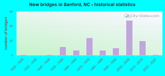
- New bridges - historical statistics
- 11920-1929
- 11940-1949
- 121950-1959
- 71960-1969
- 241970-1979
- 71980-1989
- 101990-1999
- 482000-2009
- 202010-2019
- 12020-2022
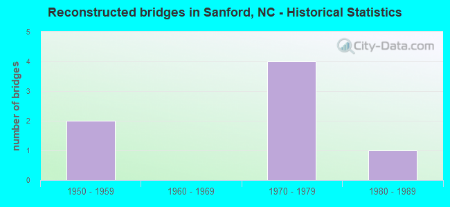
- Reconstructed bridges - Historical Statistics
- 21950-1959
- 01960-1969
- 41970-1979
- 11980-1989

- Bridge Condition - Deck
- 7.8%Very good
- 60.9%Good
- 23.4%Satisfactory
- 7.8%Fair
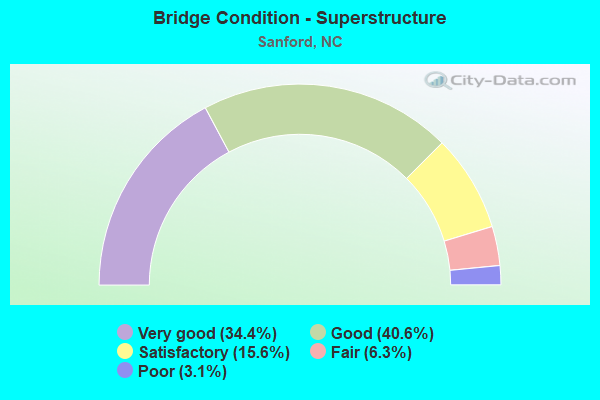
- Bridge Condition - Superstructure
- 34.4%Very good
- 40.6%Good
- 15.6%Satisfactory
- 6.3%Fair
- 3.1%Poor
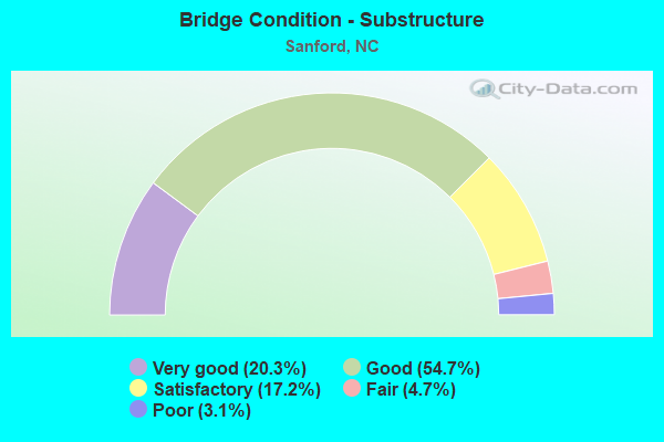
- Bridge Condition - Substructure
- 20.3%Very good
- 54.7%Good
- 17.2%Satisfactory
- 4.7%Fair
- 3.1%Poor
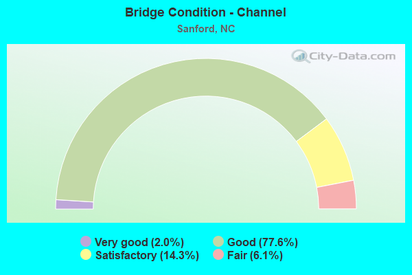
- Bridge Condition - Channel
- 2.0%Very good
- 77.6%Good
- 14.3%Satisfactory
- 6.1%Fair
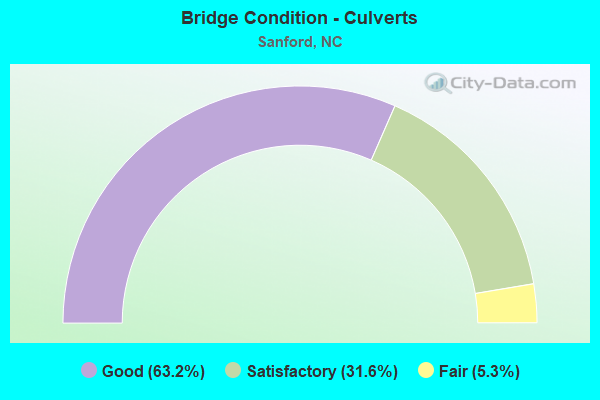
- Bridge Condition - Culverts
- 63.2%Good
- 31.6%Satisfactory
- 5.3%Fair
Find on map >> Show street view
Structure Number: 1050026, Location: 1.94 MI. N. JCT. NC42 (Lat: 35.495197, Lng: -79.195183), Route carried "under" structure: US 421, Year Built: 1977, Structure Length: 0. m, Average Daily Traffic: 8,000 (year 2018), Truck Traffic: 12%, Features Intersected: US1/15/501,NC87BUS
Minimum Vertical Clearance: 4.74m (15.55ft), Kilometerpoint: 0.000, Lanes on structure: 5, Lanes under structure: 3, Material/Design: Steel, Design/Construction: Stringer/Multi-beam, Length of Maximum Span: 31.3m (102.7ft)
Find on map >> Show street view
Structure Number: 1050026, Location: 1.94 MI. N. JCT. NC42 (Lat: 35.495197, Lng: -79.195183), Route carried "under" structure: US 421, Year Built: 1977, Structure Length: 0. m, Average Daily Traffic: 8,000 (year 2018), Truck Traffic: 12%, Features Intersected: US1/15/501,NC87BUS
Minimum Vertical Clearance: 4.92m (16.14ft), Kilometerpoint: 0.000, Lanes on structure: 5, Lanes under structure: 2, Material/Design: Steel, Design/Construction: Stringer/Multi-beam, Length of Maximum Span: 31.3m (102.7ft)
Find on map >> Show street view
Structure Number: 1050029, Location: 0.2 MI. E. JCT. SR1438 (Lat: 35.502906, Lng: -79.190911), Route carried "under" structure: Bypass US 1, Year Built: 2005, Structure Length: 0. m, Average Daily Traffic: 16,500 (year 2017), Truck Traffic: 12%, Features Intersected: SR1406
Minimum Vertical Clearance: 5.43m (17.81ft), Kilometerpoint: 0.000, Lanes on structure: 2, Lanes under structure: 4, Material/Design: Prestressed concrete continuous, Design/Construction: Stringer/Multi-beam, Length of Maximum Span: 34.1m (111.9ft)
Find on map >> Show street view
Structure Number: 1050029, Location: 0.2 MI. E. JCT. SR1438 (Lat: 35.502906, Lng: -79.190911), Route carried "under" structure: Bypass US 1, Year Built: 2005, Structure Length: 0. m, Average Daily Traffic: 16,500 (year 2017), Truck Traffic: 12%, Features Intersected: SR1406
Minimum Vertical Clearance: 5.81m (19.06ft), Kilometerpoint: 0.000, Lanes on structure: 2, Lanes under structure: 4, Material/Design: Prestressed concrete continuous, Design/Construction: Stringer/Multi-beam, Length of Maximum Span: 34.1m (111.9ft)
Find on map >> Show street view
Structure Number: 1050031, Location: 2.2 MI. N. JCT. US421 (Lat: 35.523356, Lng: -79.183722), Route carried "under" structure: US 15, Year Built: 1974, Structure Length: 0. m, Average Daily Traffic: 8,250 (year 2019), Truck Traffic: 12%, Features Intersected: US1B,US15/501,NC87
Minimum Vertical Clearance: 4.69m (15.39ft), Kilometerpoint: 0.000, Lanes on structure: 4, Lanes under structure: 1, Material/Design: Steel, Design/Construction: Stringer/Multi-beam, Length of Maximum Span: 47.2m (154.9ft)
Find on map >> Show street view
Structure Number: 1050031, Location: 2.2 MI. N. JCT. US421 (Lat: 35.523356, Lng: -79.183722), Route carried "under" structure: US 15, Year Built: 1974, Structure Length: 0. m, Average Daily Traffic: 8,250 (year 2019), Truck Traffic: 12%, Features Intersected: US1B,US15/501,NC87
Minimum Vertical Clearance: 4.72m (15.49ft), Kilometerpoint: 0.000, Lanes on structure: 4, Lanes under structure: 2, Material/Design: Steel, Design/Construction: Stringer/Multi-beam, Length of Maximum Span: 47.2m (154.9ft)
Find on map >> Show street view
Structure Number: 1050039, Location: 2.7 MI. N. JCT. NC87 (Lat: 35.561256, Lng: -79.153225), Route carried "under" structure: State highway 1415, Year Built: 1974, Structure Length: 0. m, Average Daily Traffic: 2,300 (year 2018), Truck Traffic: 7%, Features Intersected: US1 SBL
Minimum Vertical Clearance: 4.72m (15.49ft), Kilometerpoint: 0.000, Lanes on structure: 2, Lanes under structure: 2, Material/Design: Steel, Design/Construction: Stringer/Multi-beam, Length of Maximum Span: 27.7m (90.9ft)
Find on map >> Show street view
Structure Number: 105004, Location: 0.7 MI.W.JCT.SR1423 (Lat: 35.577353, Lng: -79.135300), Route carried "under" structure: US 1, Year Built: 1974, Structure Length: 0. m, Average Daily Traffic: 16,000 (year 2017), Truck Traffic: 14%, Features Intersected: SR1426
Minimum Vertical Clearance: 4.87m (15.98ft), Kilometerpoint: 22.921, Lanes on structure: 2, Lanes under structure: 2, Material/Design: Steel, Design/Construction: Stringer/Multi-beam, Length of Maximum Span: 27.4m (89.9ft)
Find on map >> Show street view
Structure Number: 105004, Location: 0.7 MI.W.JCT.SR1423 (Lat: 35.577353, Lng: -79.135300), Route carried "under" structure: US 1, Year Built: 1974, Structure Length: 0. m, Average Daily Traffic: 16,000 (year 2017), Truck Traffic: 14%, Features Intersected: SR1426
Minimum Vertical Clearance: 4.93m (16.17ft), Kilometerpoint: 22.921, Lanes on structure: 2, Lanes under structure: 2, Material/Design: Steel, Design/Construction: Stringer/Multi-beam, Length of Maximum Span: 27.4m (89.9ft)
Find on map >> Show street view
Structure Number: 1050041, Location: 1.0 MI. N. JCT. SR1426 (Lat: 35.587694, Lng: -79.121969), Route carried "under" structure: US 1, Year Built: 1997, Structure Length: 0. m, Average Daily Traffic: 16,750 (year 2019), Truck Traffic: 14%, Features Intersected: SR1423
Minimum Vertical Clearance: 5.13m (16.83ft), Kilometerpoint: 0.000, Lanes on structure: 2, Lanes under structure: 2, Material/Design: Steel continuous, Design/Construction: Stringer/Multi-beam, Length of Maximum Span: 21.9m (71.9ft)
Find on map >> Show street view
Structure Number: 1050041, Location: 1.0 MI. N. JCT. SR1426 (Lat: 35.587694, Lng: -79.121969), Route carried "under" structure: US 1, Year Built: 1997, Structure Length: 0. m, Average Daily Traffic: 16,750 (year 2019), Truck Traffic: 14%, Features Intersected: SR1423
Minimum Vertical Clearance: 5.43m (17.81ft), Kilometerpoint: 0.000, Lanes on structure: 2, Lanes under structure: 2, Material/Design: Steel continuous, Design/Construction: Stringer/Multi-beam, Length of Maximum Span: 21.9m (71.9ft)
Find on map >> Show street view
Structure Number: 1050113, Location: 2.7 MI. N. JCT. NC87 (Lat: 35.561044, Lng: -79.153025), Route carried "under" structure: Bypass Interstate 1415, Year Built: 1999, Structure Length: 0. m, Average Daily Traffic: 2,200 (year 2017), Truck Traffic: 7%, Features Intersected: US1 NBL
Minimum Vertical Clearance: 4.95m (16.24ft), Kilometerpoint: 0.000, Lanes on structure: 2, Lanes under structure: 2, Material/Design: Steel, Design/Construction: Stringer/Multi-beam, Length of Maximum Span: 27.4m (89.9ft)
Find on map >> Show street view
Structure Number: 1050115, Location: 1.1MI.N.JCT.SR1415 (Lat: 35.511272, Lng: -79.187817), Route carried "under" structure: Bypass US 1, Year Built: 2007, Structure Length: 0. m, Average Daily Traffic: 16,500 (year 2017), Truck Traffic: 12%, Features Intersected: US421N, NC87
Minimum Vertical Clearance: 7.03m (23.06ft), Kilometerpoint: 0.000, Lanes on structure: 2, Lanes under structure: 4, Material/Design: Prestressed concrete continuous, Design/Construction: Stringer/Multi-beam, Length of Maximum Span: 32.6m (107.0ft)
Find on map >> Show street view
Structure Number: 1050115, Location: 1.1MI.N.JCT.SR1415 (Lat: 35.511272, Lng: -79.187817), Route carried "under" structure: Bypass US 1, Year Built: 2007, Structure Length: 0. m, Average Daily Traffic: 14,500 (year 2013), Truck Traffic: 12%, Features Intersected: US421N, NC87
Minimum Vertical Clearance: 7.59m (24.90ft), Kilometerpoint: 0.000, Lanes on structure: 2, Lanes under structure: 4, Material/Design: Prestressed concrete continuous, Design/Construction: Stringer/Multi-beam, Length of Maximum Span: 32.6m (107.0ft)
Find on map >> Show street view
Structure Number: 1050115, Location: 1.1MI.N.JCT.SR1415 (Lat: 35.511272, Lng: -79.187817), Route carried "under" structure: Bypass US 1, Year Built: 2007, Structure Length: 0. m, Average Daily Traffic: 16,500 (year 2017), Truck Traffic: 12%, Features Intersected: US421N, NC87
Minimum Vertical Clearance: 7.16m (23.49ft), Kilometerpoint: 0.000, Lanes on structure: 2, Lanes under structure: 4, Material/Design: Prestressed concrete continuous, Design/Construction: Stringer/Multi-beam, Length of Maximum Span: 32.6m (107.0ft)
Find on map >> Show street view
Structure Number: 1050116, Location: 1.1 MI. N. JCT. SR1415 (Lat: 35.511028, Lng: -79.187900), Route carried "under" structure: Bypass US 1, Year Built: 2007, Structure Length: 0. m, Average Daily Traffic: 14,500 (year 2013), Truck Traffic: 12%, Features Intersected: US 421 SBL
Minimum Vertical Clearance: 6.12m (20.08ft), Kilometerpoint: 0.000, Lanes on structure: 2, Lanes under structure: 4, Material/Design: Prestressed concrete continuous, Design/Construction: Stringer/Multi-beam, Length of Maximum Span: 30.7m (100.7ft)
Find on map >> Show street view
Structure Number: 1050116, Location: 1.1 MI. N. JCT. SR1415 (Lat: 35.511028, Lng: -79.187900), Route carried "under" structure: Bypass US 1, Year Built: 2007, Structure Length: 0. m, Average Daily Traffic: 14,500 (year 2013), Truck Traffic: 12%, Features Intersected: US 421 SBL
Minimum Vertical Clearance: 6.14m (20.14ft), Kilometerpoint: 0.000, Lanes on structure: 2, Lanes under structure: 4, Material/Design: Prestressed concrete continuous, Design/Construction: Stringer/Multi-beam, Length of Maximum Span: 30.7m (100.7ft)
Find on map >> Show street view
Structure Number: 1050117, Location: 1.1 MI. N. JCT.SR1415 (Lat: 35.511458, Lng: -79.187753), Route carried "under" structure: Bypass US 1, Year Built: 2007, Structure Length: 0. m, Average Daily Traffic: 15,500 (year 2013), Truck Traffic: 12%, Features Intersected: US421(FUT) NBL COL
Minimum Vertical Clearance: 7.59m (24.90ft), Kilometerpoint: 0.000, Lanes on structure: 2, Lanes under structure: 4, Material/Design: Prestressed concrete continuous, Design/Construction: Tee Beam, Length of Maximum Span: 32.6m (107.0ft)
Find on map >> Show street view
Structure Number: 1050117, Location: 1.1 MI. N. JCT.SR1415 (Lat: 35.511458, Lng: -79.187753), Route carried "under" structure: Bypass US 1, Year Built: 2007, Structure Length: 0. m, Average Daily Traffic: 15,500 (year 2013), Truck Traffic: 12%, Features Intersected: US421(FUT) NBL COL
Minimum Vertical Clearance: 7.36m (24.15ft), Kilometerpoint: 0.000, Lanes on structure: 2, Lanes under structure: 4, Material/Design: Prestressed concrete continuous, Design/Construction: Tee Beam, Length of Maximum Span: 32.6m (107.0ft)
Find on map >> Show street view
Structure Number: 1050118, Location: 0.45 MI. W. JCT. US1 BUS (Lat: 35.510836, Lng: -79.187967), Route carried "under" structure: Bypass US 1, Year Built: 2007, Structure Length: 0. m, Average Daily Traffic: 22,000 (year 2019), Truck Traffic: 12%, Features Intersected: US421,NC87 SBL COL
Minimum Vertical Clearance: 5.53m (18.14ft), Kilometerpoint: 0.000, Lanes on structure: 2, Lanes under structure: 4, Material/Design: Prestressed concrete continuous, Design/Construction: Stringer/Multi-beam, Length of Maximum Span: 30.7m (100.7ft)
Find on map >> Show street view
Structure Number: 1050118, Location: 0.45 MI. W. JCT. US1 BUS (Lat: 35.510836, Lng: -79.187967), Route carried "under" structure: Bypass US 1, Year Built: 2007, Structure Length: 0. m, Average Daily Traffic: 22,000 (year 2019), Truck Traffic: 12%, Features Intersected: US421,NC87 SBL COL
Minimum Vertical Clearance: 5.48m (17.98ft), Kilometerpoint: 0.000, Lanes on structure: 2, Lanes under structure: 4, Material/Design: Prestressed concrete continuous, Design/Construction: Stringer/Multi-beam, Length of Maximum Span: 30.7m (100.7ft)
Find on map >> Show street view
Structure Number: 1050119, Location: 0.45 MI. N. JCT. SR1406 (Lat: 35.508961, Lng: -79.178839), Route carried "under" structure: Bypass US 421, Year Built: 2004, Structure Length: 0. m, Average Daily Traffic: 12,500 (year 2015), Truck Traffic: 12%, Features Intersected: US1BUS
Minimum Vertical Clearance: 6.01m (19.72ft), Kilometerpoint: 0.000, Lanes on structure: 2, Lanes under structure: 3, Material/Design: Steel continuous, Design/Construction: Stringer/Multi-beam, Length of Maximum Span: 40.8m (133.9ft)
Find on map >> Show street view
Structure Number: 1050119, Location: 0.45 MI. N. JCT. SR1406 (Lat: 35.508961, Lng: -79.178839), Route carried "under" structure: Bypass US 421, Year Built: 2004, Structure Length: 0. m, Average Daily Traffic: 12,500 (year 2015), Truck Traffic: 12%, Features Intersected: US1BUS
Minimum Vertical Clearance: 5.94m (19.49ft), Kilometerpoint: 0.000, Lanes on structure: 2, Lanes under structure: 3, Material/Design: Steel continuous, Design/Construction: Stringer/Multi-beam, Length of Maximum Span: 40.8m (133.9ft)
Find on map >> Show street view
Structure Number: 1050124, Location: 0.6 MI.E.JCT. US1BUS. (Lat: 35.507453, Lng: -79.168314), Route carried "under" structure: Bypass US 421, Year Built: 2004, Structure Length: 0. m, Average Daily Traffic: 6,000 (year 2013), Truck Traffic: 12%, Features Intersected: SR1415
Minimum Vertical Clearance: 5.20m (17.06ft), Kilometerpoint: 0.000, Lanes on structure: 2, Lanes under structure: 3, Material/Design: Steel continuous, Design/Construction: Stringer/Multi-beam, Length of Maximum Span: 36.8m (120.7ft)
Find on map >> Show street view
Structure Number: 1050124, Location: 0.6 MI.E.JCT. US1BUS. (Lat: 35.507453, Lng: -79.168314), Route carried "under" structure: Bypass US 421, Year Built: 2004, Structure Length: 0. m, Average Daily Traffic: 6,000 (year 2013), Truck Traffic: 12%, Features Intersected: SR1415
Minimum Vertical Clearance: 5.46m (17.91ft), Kilometerpoint: 0.000, Lanes on structure: 2, Lanes under structure: 3, Material/Design: Steel continuous, Design/Construction: Stringer/Multi-beam, Length of Maximum Span: 36.8m (120.7ft)
Find on map >> Show street view
Structure Number: 1050125, Location: 1.2 MI. N. JCT. SR1521 (Lat: 35.498136, Lng: -79.145028), Route carried "under" structure: Bypass US 421, Year Built: 2003, Structure Length: 0. m, Average Daily Traffic: 13,000 (year 2015), Truck Traffic: 12%, Features Intersected: SR1002
Minimum Vertical Clearance: 6.11m (20.05ft), Kilometerpoint: 44.592, Lanes on structure: 2, Lanes under structure: 2, Material/Design: Steel continuous, Design/Construction: Stringer/Multi-beam, Length of Maximum Span: 45.1m (148.0ft)
Find on map >> Show street view
Structure Number: 1050125, Location: 1.2 MI. N. JCT. SR1521 (Lat: 35.498136, Lng: -79.145028), Route carried "under" structure: Bypass US 421, Year Built: 2003, Structure Length: 0. m, Average Daily Traffic: 13,000 (year 2015), Truck Traffic: 12%, Features Intersected: SR1002
Minimum Vertical Clearance: 5.35m (17.55ft), Kilometerpoint: 44.592, Lanes on structure: 2, Lanes under structure: 2, Material/Design: Steel continuous, Design/Construction: Stringer/Multi-beam, Length of Maximum Span: 45.1m (148.0ft)
Find on map >> Show street view
Structure Number: 1050126, Location: 0.65 MI. N. JCT. SR1521 (Lat: 35.491292, Lng: -79.140558), Route carried "under" structure: Bypass US 421, Year Built: 2003, Structure Length: 0. m, Average Daily Traffic: 14,500 (year 2018), Truck Traffic: 12%, Features Intersected: SR1509
Minimum Vertical Clearance: 6.54m (21.46ft), Kilometerpoint: 44.348, Lanes on structure: 2, Lanes under structure: 2, Material/Design: Steel continuous, Design/Construction: Stringer/Multi-beam, Length of Maximum Span: 40.8m (133.9ft)
Find on map >> Show street view
Structure Number: 1050126, Location: 0.65 MI. N. JCT. SR1521 (Lat: 35.491292, Lng: -79.140558), Route carried "under" structure: Bypass US 421, Year Built: 2003, Structure Length: 0. m, Average Daily Traffic: 14,500 (year 2018), Truck Traffic: 12%, Features Intersected: SR1509
Minimum Vertical Clearance: 5.09m (16.70ft), Kilometerpoint: 44.348, Lanes on structure: 2, Lanes under structure: 2, Material/Design: Steel continuous, Design/Construction: Stringer/Multi-beam, Length of Maximum Span: 40.8m (133.9ft)
Find on map >> Show street view
Structure Number: 1050127, Location: 0.65 MI. S. JCT. SR1506 (Lat: 35.483608, Lng: -79.133475), Route carried "under" structure: Alternate US 421, Year Built: 2003, Structure Length: 0. m, Average Daily Traffic: 13,500 (year 2018), Truck Traffic: 14%, Features Intersected: SR1521
Minimum Vertical Clearance: 5.51m (18.08ft), Kilometerpoint: 0.000, Lanes on structure: 2, Lanes under structure: 2, Material/Design: Steel continuous, Design/Construction: Stringer/Multi-beam, Length of Maximum Span: 38.7m (127.0ft)
Find on map >> Show street view
Structure Number: 1050127, Location: 0.65 MI. S. JCT. SR1506 (Lat: 35.483608, Lng: -79.133475), Route carried "under" structure: Alternate US 421, Year Built: 2003, Structure Length: 0. m, Average Daily Traffic: 13,500 (year 2018), Truck Traffic: 14%, Features Intersected: SR1521
Minimum Vertical Clearance: 6.65m (21.82ft), Kilometerpoint: 0.000, Lanes on structure: 2, Lanes under structure: 2, Material/Design: Steel continuous, Design/Construction: Stringer/Multi-beam, Length of Maximum Span: 38.7m (127.0ft)
Find on map >> Show street view
Structure Number: 1050128, Location: 0.8 MI. N. JCT. SR1596 (Lat: 35.472144, Lng: -79.121656), Route carried "under" structure: Bypass US 421, Year Built: 2008, Structure Length: 0. m, Average Daily Traffic: 13,500 (year 2018), Truck Traffic: 12%, Features Intersected: SR1524
Minimum Vertical Clearance: 5.30m (17.39ft), Kilometerpoint: 0.000, Lanes on structure: 2, Lanes under structure: 2, Material/Design: Steel continuous, Design/Construction: Stringer/Multi-beam, Length of Maximum Span: 38.7m (127.0ft)
Find on map >> Show street view
Structure Number: 1050128, Location: 0.8 MI. N. JCT. SR1596 (Lat: 35.472144, Lng: -79.121656), Route carried "under" structure: Bypass US 421, Year Built: 2008, Structure Length: 0. m, Average Daily Traffic: 13,500 (year 2018), Truck Traffic: 12%, Features Intersected: SR1524
Minimum Vertical Clearance: 5.71m (18.73ft), Kilometerpoint: 0.000, Lanes on structure: 2, Lanes under structure: 2, Material/Design: Steel continuous, Design/Construction: Stringer/Multi-beam, Length of Maximum Span: 38.7m (127.0ft)
Find on map >> Show street view
Structure Number: 1050129, Location: 09 MI. N. JCT. US421 BUS (Lat: 35.460511, Lng: -79.118225), Route carried "under" structure: State highway 42, Year Built: 2007, Structure Length: 0. m, Average Daily Traffic: 6,500 (year 2017), Truck Traffic: 6%, Features Intersected: US421NB,NC87N BYP.
Minimum Vertical Clearance: 5.28m (17.32ft), Kilometerpoint: 0.000, Lanes on structure: 3, Lanes under structure: 4, Material/Design: Steel, Design/Construction: Stringer/Multi-beam, Length of Maximum Span: 42.3m (138.8ft)
Find on map >> Show street view
Structure Number: 105013, Location: 0.9 MI. N. JCT. US421BUS. (Lat: 35.460600, Lng: -79.118500), Route carried "under" structure: State highway 42, Year Built: 2007, Structure Length: 0. m, Average Daily Traffic: 13,000 (year 2017), Truck Traffic: 6%, Features Intersected: US421S, NC87S BYP.
Minimum Vertical Clearance: 5.28m (17.32ft), Kilometerpoint: 0.000, Lanes on structure: 3, Lanes under structure: 4, Material/Design: Steel, Design/Construction: Stringer/Multi-beam, Length of Maximum Span: 42.0m (137.8ft)
Find on map >> Show street view
Structure Number: 1050135, Location: 1.0 MI. S. JCT. NC42 (Lat: 35.446750, Lng: -79.118858), Route carried "under" structure: US 421, Year Built: 2013, Structure Length: 0. m, Average Daily Traffic: 5,250 (year 2019), Truck Traffic: 12%, Features Intersected: US421(FUT),NC87N
Minimum Vertical Clearance: 5.89m (19.32ft), Kilometerpoint: 40.843, Lanes on structure: 2, Lanes under structure: 2, Material/Design: Prestressed concrete continuous, Design/Construction: Stringer/Multi-beam, Length of Maximum Span: 31.0m (101.7ft)
Find on map >> Show street view
Structure Number: 1050135, Location: 1.0 MI. S. JCT. NC42 (Lat: 35.446750, Lng: -79.118858), Route carried "under" structure: Business US 421, Year Built: 2013, Structure Length: 0. m, Average Daily Traffic: 5,250 (year 2019), Truck Traffic: 12%, Features Intersected: US421(FUT),NC87N
Minimum Vertical Clearance: 5.89m (19.32ft), Kilometerpoint: 40.843, Lanes on structure: 2, Lanes under structure: 2, Material/Design: Prestressed concrete continuous, Design/Construction: Stringer/Multi-beam, Length of Maximum Span: 31.0m (101.7ft)
Find on map >> Show street view
Structure Number: 1050136, Location: 0.1 MI. S. JCT. NC42 (Lat: 35.446750, Lng: -79.118858), Route carried "under" structure: Bypass US 421, Year Built: 2013, Structure Length: 0. m, Average Daily Traffic: 15,500 (year 2019), Truck Traffic: 12%, Features Intersected: US421S,NC87S
Minimum Vertical Clearance: 5.10m (16.73ft), Kilometerpoint: 40.843, Lanes on structure: 3, Lanes under structure: 2, Material/Design: Prestressed concrete continuous, Design/Construction: Stringer/Multi-beam, Length of Maximum Span: 31.0m (101.7ft)
Find on map >> Show street view
Structure Number: 1050136, Location: 0.1 MI. S. JCT. NC42 (Lat: 35.446750, Lng: -79.118858), Route carried "under" structure: Bypass US 241, Year Built: 2013, Structure Length: 0. m, Average Daily Traffic: 15,500 (year 2019), Truck Traffic: 12%, Features Intersected: US421S,NC87S, Facility Carried by Structure: US421S
Minimum Vertical Clearance: 5.10m (16.73ft), Kilometerpoint: 40.843, Lanes on structure: 3, Lanes under structure: 2, Material/Design: Prestressed concrete continuous, Design/Construction: Stringer/Multi-beam, Length of Maximum Span: 31.0m (101.7ft)
Find on map >> Show street view
Structure Number: 1050137, Location: 1.1 MI. S. JCT. US421 (Lat: 35.433783, Lng: -79.122617), Route carried "under" structure: Bypass State highway 87, Year Built: 2012, Structure Length: 0. m, Average Daily Traffic: 7,500 (year 2013), Truck Traffic: 12%, Features Intersected: NC87 BUS. NBL
Minimum Vertical Clearance: 5.35m (17.55ft), Kilometerpoint: 0.000, Lanes on structure: 2, Lanes under structure: 2, Material/Design: Steel continuous, Design/Construction: Stringer/Multi-beam, Length of Maximum Span: 46.0m (150.9ft)
Find on map >> Show street view
Structure Number: 1050137, Location: 1.1 MI. S. JCT. US421 (Lat: 35.433783, Lng: -79.122617), Route carried "under" structure: Bypass State highway 87, Year Built: 2012, Structure Length: 0. m, Average Daily Traffic: 7,500 (year 2013), Truck Traffic: 12%, Features Intersected: NC87 BUS. NBL
Minimum Vertical Clearance: 6.19m (20.31ft), Kilometerpoint: 0.000, Lanes on structure: 2, Lanes under structure: 2, Material/Design: Steel continuous, Design/Construction: Stringer/Multi-beam, Length of Maximum Span: 46.0m (150.9ft)
Find on map >> Show street view
Structure Number: 1050153, Location: 1.9 MI. S. JCT. SR2146 (Lat: 35.540689, Lng: -79.240719), Route carried "under" structure: US 421, Year Built: 2015, Structure Length: 0. m, Average Daily Traffic: 8,000 (year 2018), Truck Traffic: 14%, Features Intersected: US401BUS,SR1400
Minimum Vertical Clearance: 6.14m (20.14ft), Kilometerpoint: 0.000, Lanes on structure: 4, Lanes under structure: 3, Material/Design: Steel continuous, Design/Construction: Stringer/Multi-beam, Length of Maximum Span: 44.5m (146.0ft)
Find on map >> Show street view
Structure Number: 1050153, Location: 1.9 MI. S. JCT. SR2146 (Lat: 35.540689, Lng: -79.240719), Route carried "under" structure: US 421, Year Built: 2015, Structure Length: 0. m, Average Daily Traffic: 8,000 (year 2018), Truck Traffic: 14%, Features Intersected: US401BUS,SR1400
Minimum Vertical Clearance: 6.09m (19.98ft), Kilometerpoint: 0.000, Lanes on structure: 4, Lanes under structure: 3, Material/Design: Steel continuous, Design/Construction: Stringer/Multi-beam, Length of Maximum Span: 44.5m (146.0ft)