Bridge Statistics for Sapulpa, Oklahoma (OK)
Condition, Traffic, Stress, Structural Evaluation, Project Costs
- National Bridge Inventory (NBI) Statistics
- 102Number of bridges
- 1,293ft / 394mTotal length
- $116,609,000Total costs
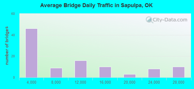
- 850,025Total average daily traffic
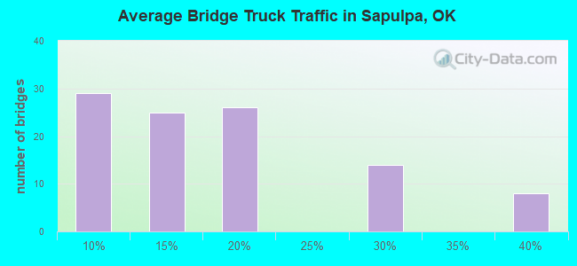
- 146,007Total average daily truck traffic
- National Bridge Inventory (NBI) Registered Bridges for Sapulpa
- No street view available for this location
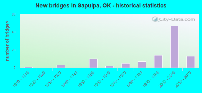
- New bridges - historical statistics
- 11910-1919
- 31930-1939
- 101950-1959
- 21960-1969
- 51970-1979
- 71980-1989
- 141990-1999
- 472000-2009
- 132010-2019
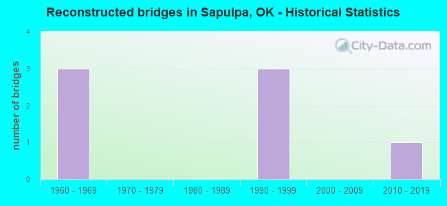
- Reconstructed bridges - Historical Statistics
- 31960-1969
- 01970-1979
- 01980-1989
- 31990-1999
- 02000-2009
- 12010-2019
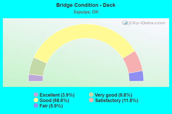
- Bridge Condition - Deck
- 3.9%Excellent
- 9.8%Very good
- 68.6%Good
- 11.8%Satisfactory
- 5.9%Fair
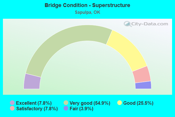
- Bridge Condition - Superstructure
- 7.8%Excellent
- 54.9%Very good
- 25.5%Good
- 7.8%Satisfactory
- 3.9%Fair
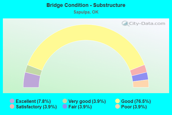
- Bridge Condition - Substructure
- 7.8%Excellent
- 3.9%Very good
- 76.5%Good
- 3.9%Satisfactory
- 3.9%Fair
- 3.9%Poor
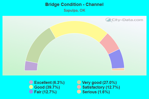
- Bridge Condition - Channel
- 6.3%Excellent
- 27.0%Very good
- 39.7%Good
- 12.7%Satisfactory
- 12.7%Fair
- 1.6%Serious
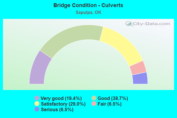
- Bridge Condition - Culverts
- 19.4%Very good
- 38.7%Good
- 29.0%Satisfactory
- 6.5%Fair
- 6.5%Serious
Find on map >> Show street view
Structure Number: 3186, Location: 79.4 NE JCT I-35 (Lat: 36.010278, Lng: -96.114722), Route carried "on" structure: Ramp Other road , Year Built: 1953, Status: Open, Structure Length: 7.99m (26.21ft), Average Daily Traffic: 15,750 (year 2020), Truck Traffic: 14%, Average Future Daily Traffic: 25,200 (year 2040), Design Load: HL 93, Features Intersected: TURNER TP (I-44) UNDER, Facility Carried by Structure: SAPULPA INTERCHANG
Minimum Vertical Clearance: 30+ m (98+ ft), Kilometerpoint: 53.789, Lanes on structure: 2, Lanes under structure: 6, Toll: On toll road, Owner: State Toll Authority, Approaching Roadway Width: 19.5m (64.0ft), Skew: 30 degrees, Material/Design: Prestressed concrete, Design/Construction: Stringer/Multi-beam, Number Of Spans In Main Unit: 2, Length of Maximum Span: 41.5m (136.2ft), Curb-To-Curb Width: 17.7m (58.1ft), Out-to-Out Width: 19.2m (63.0ft)
Condition: Deck: Excellent, Superstructure: Excellent, Substructure: Excellent, Operating Rating: 53.9 metric tons, Method Used To Determine Operating Rating: Load and Resistance Factor (LRFR), Inventory Rating: 41.5 metric tons, Method Used To Determine Inventory Rating: Load and Resistance Factor (LRFR), Structural Evaluation: Superior to present desirable criteria, Deck Geometry: Superior to present desirable criteria, Underclear: Equal to present minimum criteria, Approach Roadway Alignment: Equal to present minimum criteria, Designated Inspection Frequency: Every 24 months, Inspection Date: June 2020, Deck Structure Type: Concrete Cast-file-Place, Wearing Surface/Protective System: Wearing Surface: Monolithic Concrete, Deck Protection: Epoxy Coated Reinforcing
Find on map >> Show street view
Structure Number: 31861, Location: 77.6 NE JCT I-35 (Lat: 35.997222, Lng: -96.163333), Route carried "on" structure: County highway 1954C, Year Built: 2018, Status: Open, Structure Length: 7.56m (24.80ft), Average Daily Traffic: 150 (year 2020), Truck Traffic: 7%, Average Future Daily Traffic: 240 (year 2040), Design Load: HL 93, Features Intersected: TURNER TP (I-44) UNDER
Minimum Vertical Clearance: 30+ m (98+ ft), Kilometerpoint: 79.547, Lanes on structure: 2, Lanes under structure: 6, Owner: State Toll Authority, Approaching Roadway Width: 8.5m (27.9ft), Skew: 11 degrees, Material/Design: Prestressed concrete, Design/Construction: Stringer/Multi-beam, Number Of Spans In Main Unit: 2, Length of Maximum Span: 37.8m (124.0ft), Curb-To-Curb Width: 7.9m (25.9ft), Out-to-Out Width: 8.6m (28.2ft)
Condition: Deck: Excellent, Superstructure: Excellent, Substructure: Excellent, Operating Rating: 43.5 metric tons, Method Used To Determine Operating Rating: Load and Resistance Factor (LRFR), Inventory Rating: 33.7 metric tons, Method Used To Determine Inventory Rating: Load and Resistance Factor (LRFR), Structural Evaluation: Superior to present desirable criteria, Deck Geometry: Somewhat better than minimum adequacy, Underclear: Equal to present minimum criteria, Approach Roadway Alignment: Equal to present minimum criteria, Designated Inspection Frequency: Every 24 months, Inspection Date: June 2020, Deck Structure Type: Concrete Cast-file-Place, Wearing Surface/Protective System: Wearing Surface: Monolithic Concrete, Deck Protection: Epoxy Coated Reinforcing
Find on map >> Show street view
Structure Number: 26017, Location: 00.01 (Lat: 36.024819, Lng: -96.093289), Route carried "under" structure: Ramp Other road 44, Year Built: 2000, Structure Length: 0. m, Average Daily Traffic: 5,000 (year 2020), Truck Traffic: 8%, Features Intersected: TURNER TP (I-44) UNDER, Facility Carried by Structure: 96TH ST. S.
Minimum Vertical Clearance: 5.41m (17.75ft), Kilometerpoint: 56.556, Lanes on structure: 2, Lanes under structure: 1, Toll: On toll road, Material/Design: Prestressed concrete continuous, Design/Construction: Stringer/Multi-beam, Length of Maximum Span: 32.6m (107.0ft)
Find on map >> Show street view
Structure Number: 26017, Location: 00.01 (Lat: 36.024819, Lng: -96.093289), Route carried "under" structure: Other road 44, Year Built: 2000, Structure Length: 0. m, Average Daily Traffic: 26,300 (year 2020), Truck Traffic: 8%, Features Intersected: TURNER TP (I-44) UNDER, Facility Carried by Structure: 96TH ST. S.
Minimum Vertical Clearance: 5.41m (17.75ft), Kilometerpoint: 56.556, Lanes on structure: 2, Lanes under structure: 6, Toll: On toll road, Material/Design: Prestressed concrete continuous, Design/Construction: Stringer/Multi-beam, Length of Maximum Span: 32.6m (107.0ft)
Find on map >> Show street view
Structure Number: 26018, Location: 83.01 S (Lat: 36.028442, Lng: -96.092219), Route carried "under" structure: Other road , Year Built: 2000, Structure Length: 0. m, Average Daily Traffic: 15,700 (year 2020), Truck Traffic: 16%, Features Intersected: CREEK TP & CREEK UNDER, Facility Carried by Structure: TURNER TP (I-44)
Minimum Vertical Clearance: 5.11m (16.77ft), Kilometerpoint: 0.322, Lanes on structure: 2, Lanes under structure: 1, Toll: On toll road, Material/Design: Prestressed concrete, Design/Construction: Stringer/Multi-beam, Length of Maximum Span: 45.1m (148.0ft)
Find on map >> Show street view
Structure Number: 26019, Location: 83.01 N (Lat: 36.028611, Lng: -96.092500), Route carried "under" structure: Other road , Year Built: 2000, Structure Length: 0. m, Average Daily Traffic: 8,050 (year 2020), Truck Traffic: 16%, Features Intersected: CREEK TP & CREEK UNDER, Facility Carried by Structure: TURNER TP (I-44)
Minimum Vertical Clearance: 5.72m (18.77ft), Kilometerpoint: 0.000, Lanes on structure: 2, Lanes under structure: 1, Toll: On toll road, Material/Design: Steel continuous, Design/Construction: Stringer/Multi-beam, Length of Maximum Span: 46.0m (150.9ft)
Find on map >> Show street view
Structure Number: 26022, Location: 00.13N (Lat: 36.029236, Lng: -96.088558), Route carried "under" structure: Business State highway 66, Year Built: 2000, Structure Length: 0. m, Average Daily Traffic: 16,700 (year 2020), Truck Traffic: 5%, Features Intersected: S.H. 66 UNDER, Facility Carried by Structure: CREEK TP E-S RAMP
Minimum Vertical Clearance: 5.21m (17.09ft), Kilometerpoint: 5.649, Lanes on structure: 1, Lanes under structure: 4, Material/Design: Prestressed concrete, Design/Construction: Stringer/Multi-beam, Length of Maximum Span: 32.6m (107.0ft)
Find on map >> Show street view
Structure Number: 26023, Location: 00.13S (Lat: 36.029086, Lng: -96.089500), Route carried "under" structure: Business State highway 66, Year Built: 2000, Structure Length: 0. m, Average Daily Traffic: 16,700 (year 2020), Truck Traffic: 16%, Features Intersected: S.H. 66 UNDER, Facility Carried by Structure: CREEK TP S-E RAMP
Minimum Vertical Clearance: 5.59m (18.34ft), Kilometerpoint: 5.633, Lanes on structure: 1, Lanes under structure: 4, Material/Design: Prestressed concrete, Design/Construction: Stringer/Multi-beam, Length of Maximum Span: 32.8m (107.6ft)
Find on map >> Show street view
Structure Number: 26028, Location: 00.97 (Lat: 36.024769, Lng: -96.075367), Route carried "under" structure: Other road , Year Built: 2000, Structure Length: 0. m, Average Daily Traffic: 20,300 (year 2020), Truck Traffic: 25%, Features Intersected: CREEK TP UNDER, Facility Carried by Structure: 96TH ST. S.
Minimum Vertical Clearance: 5.33m (17.49ft), Kilometerpoint: 1.561, Lanes on structure: 2, Lanes under structure: 4, Toll: On toll road, Material/Design: Prestressed concrete, Design/Construction: Stringer/Multi-beam, Length of Maximum Span: 29.6m (97.1ft)
Find on map >> Show street view
Structure Number: 26031, Location: 01.67 (Lat: 36.018186, Lng: -96.066383), Route carried "under" structure: Other road , Year Built: 2000, Structure Length: 0. m, Average Daily Traffic: 20,300 (year 2020), Truck Traffic: 10%, Features Intersected: CREEK TP UNDER, Facility Carried by Structure: HICKORY HILL RD.
Minimum Vertical Clearance: 5.21m (17.09ft), Kilometerpoint: 2.688, Lanes on structure: 2, Lanes under structure: 4, Toll: On toll road, Material/Design: Prestressed concrete, Design/Construction: Stringer/Multi-beam, Length of Maximum Span: 24.4m (80.1ft)
Find on map >> Show street view
Structure Number: 26033, Location: 02.29 (Lat: 36.013764, Lng: -96.056478), Route carried "under" structure: Other road , Year Built: 2000, Structure Length: 0. m, Average Daily Traffic: 20,300 (year 2020), Truck Traffic: 10%, Features Intersected: CREEK TP UNDER, Facility Carried by Structure: HILTON RD.
Minimum Vertical Clearance: 5.26m (17.26ft), Kilometerpoint: 4.328, Lanes on structure: 2, Lanes under structure: 4, Toll: On toll road, Material/Design: Prestressed concrete, Design/Construction: Stringer/Multi-beam, Length of Maximum Span: 27.4m (89.9ft)
Find on map >> Show street view
Structure Number: 26034, Location: 02.81 (Lat: 36.012200, Lng: -96.047364), Route carried "under" structure: Other road , Year Built: 2000, Structure Length: 0. m, Average Daily Traffic: 20,300 (year 2020), Truck Traffic: 10%, Features Intersected: CREEK TP UNDER, Facility Carried by Structure: S 49TH ST. W
Minimum Vertical Clearance: 5.28m (17.32ft), Kilometerpoint: 5.164, Lanes on structure: 2, Lanes under structure: 4, Toll: On toll road, Material/Design: Prestressed concrete, Design/Construction: Stringer/Multi-beam, Length of Maximum Span: 25.9m (85.0ft)
Find on map >> Show street view
Structure Number: 26035, Location: 03.38 (Lat: 36.009181, Lng: -96.038286), Route carried "under" structure: ServiceCity street , Year Built: 2000, Structure Length: 0. m, Average Daily Traffic: 24 (year 2020), Truck Traffic: 5%, Features Intersected: EQUIPMENT PASS UNDER, Facility Carried by Structure: CREEK TP
Minimum Vertical Clearance: 4.72m (15.49ft), Kilometerpoint: 6.082, Lanes on structure: 4, Lanes under structure: 2, Material/Design: Concrete, Design/Construction: Slab, Length of Maximum Span: 8.5m (27.9ft)
Find on map >> Show street view
Structure Number: 27635, Location: 84.4 MI E OF I-35 (Lat: 36.046653, Lng: -96.078761), Route carried "under" structure: Other road 44, Year Built: 2003, Structure Length: 0. m, Average Daily Traffic: 26,300 (year 2020), Truck Traffic: 5%, Features Intersected: TURNER TP (I-44) UNDER, Facility Carried by Structure: E0670 (81ST ST.)
Minimum Vertical Clearance: 4.98m (16.34ft), Kilometerpoint: 59.275, Lanes on structure: 4, Lanes under structure: 4, Toll: On toll road, Material/Design: Steel, Design/Construction: Stringer/Multi-beam, Length of Maximum Span: 19.2m (63.0ft)
Find on map >> Show street view
Structure Number: 27865, Location: 1.0 MI N OF SH 66 (Lat: 36.011169, Lng: -96.111758), Route carried "under" structure: Interstate 44, Year Built: 1997, Structure Length: 0. m, Average Daily Traffic: 26,300 (year 2020), Truck Traffic: 12%, Features Intersected: TURNER TP (I-44) UNDER, Facility Carried by Structure: S.H. 97
Minimum Vertical Clearance: 7.44m (24.41ft), Kilometerpoint: 54.095, Lanes on structure: 4, Lanes under structure: 6, Toll: On toll road, Material/Design: Steel, Design/Construction: Stringer/Multi-beam, Length of Maximum Span: 65.5m (214.9ft)
Find on map >> Show street view
Structure Number: 28573, Location: 81.4MI.NE JCT. I-35 (Lat: 36.014917, Lng: -96.100828), Route carried "under" structure: State highway 166, Year Built: 2006, Structure Length: 0. m, Average Daily Traffic: 3,000 (year 2020), Truck Traffic: 15%, Features Intersected: S.H. 166 / R.R. UNDER, Facility Carried by Structure: TURNER TP (I-44)
Minimum Vertical Clearance: 6.48m (21.26ft), Kilometerpoint: 1.110, Lanes on structure: 4, Lanes under structure: 2, Material/Design: Steel, Design/Construction: Stringer/Multi-beam, Length of Maximum Span: 41.1m (134.8ft)
Find on map >> Show street view
Structure Number: 31789, Location: 24.3 E PAYNE C/L (Lat: 35.987222, Lng: -96.194167), Route carried "under" structure: State highway 33, Year Built: 2018, Structure Length: 0. m, Average Daily Traffic: 5,000 (year 2020), Truck Traffic: 16%, Features Intersected: S.H. 33 UNDER, Facility Carried by Structure: TURNER TP (I-44)
Minimum Vertical Clearance: 5.49m (18.01ft), Kilometerpoint: 46.146, Lanes on structure: 6, Lanes under structure: 4, Material/Design: Prestressed concrete, Design/Construction: Stringer/Multi-beam, Length of Maximum Span: 14.9m (48.9ft)
Find on map >> Show street view
Structure Number: 31858, Location: 78.8 NE JCT I-35 (Lat: 36.002303, Lng: -96.143636), Route carried "under" structure: Other road 44, Year Built: 2018, Structure Length: 0. m, Average Daily Traffic: 25,900 (year 2020), Truck Traffic: 25%, Features Intersected: TURNER TP, Facility Carried by Structure: CO RD N3845
Minimum Vertical Clearance: 5.24m (17.19ft), Kilometerpoint: 82.136, Lanes on structure: 2, Lanes under structure: 6, Toll: Toll bridge, Material/Design: Prestressed concrete, Design/Construction: Stringer/Multi-beam, Length of Maximum Span: 43.3m (142.1ft)
Find on map >> Show street view
Structure Number: 31859, Location: 79.2 NE JCT I-35 (Lat: 36.004758, Lng: -96.136328), Route carried "under" structure: Other road 44, Year Built: 2018, Structure Length: 0. m, Average Daily Traffic: 25,900 (year 2020), Truck Traffic: 36%, Features Intersected: TURNER TP (I-44) UNDER, Facility Carried by Structure: S. 145TH W. AVE
Minimum Vertical Clearance: 5.33m (17.49ft), Kilometerpoint: 83.329, Lanes on structure: 2, Lanes under structure: 6, Toll: On toll road, Material/Design: Prestressed concrete, Design/Construction: Stringer/Multi-beam, Length of Maximum Span: 24.4m (80.1ft)
Find on map >> Show street view
Structure Number: 3186, Location: 79.4 NE JCT I-35 (Lat: 36.010278, Lng: -96.114722), Route carried "under" structure: Other road 44, Year Built: 1953, Structure Length: 0. m, Average Daily Traffic: 25,900 (year 2020), Truck Traffic: 12%, Features Intersected: TURNER TP (I-44) UNDER, Facility Carried by Structure: SAPULPA INTERCHANG
Minimum Vertical Clearance: 5.21m (17.09ft), Kilometerpoint: 86.565, Lanes on structure: 2, Lanes under structure: 6, Toll: On toll road, Material/Design: Prestressed concrete, Design/Construction: Stringer/Multi-beam, Length of Maximum Span: 41.5m (136.2ft)
Find on map >> Show street view
Structure Number: 31861, Location: 77.6 NE JCT I-35 (Lat: 35.997222, Lng: -96.163333), Route carried "under" structure: Other road 44, Year Built: 2018, Structure Length: 0. m, Average Daily Traffic: 25,900 (year 2020), Truck Traffic: 36%, Features Intersected: TURNER TP (I-44) UNDER, Facility Carried by Structure: CO. RD. 1954C
Minimum Vertical Clearance: 5.21m (17.09ft), Kilometerpoint: 79.133, Lanes on structure: 2, Lanes under structure: 6, Toll: On toll road, Material/Design: Prestressed concrete, Design/Construction: Stringer/Multi-beam, Length of Maximum Span: 37.8m (124.0ft)