Bridge Statistics for Schertz, Texas (TX)
Condition, Traffic, Stress, Structural Evaluation, Project Costs
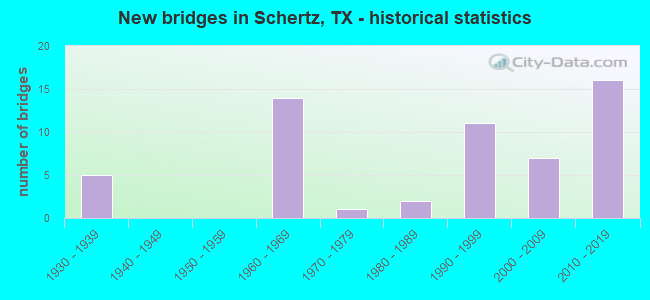
- New bridges - historical statistics
- 51930-1939
- 141960-1969
- 11970-1979
- 21980-1989
- 111990-1999
- 72000-2009
- 162010-2019
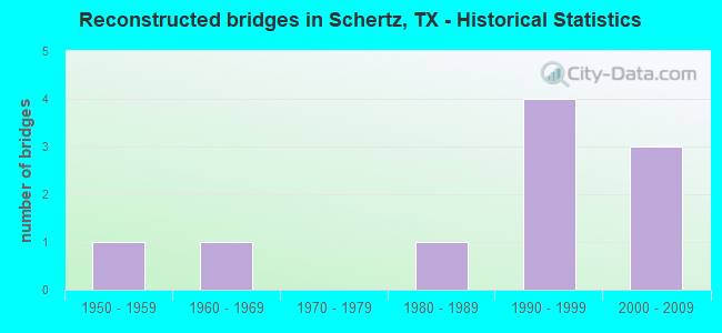
- Reconstructed bridges - Historical Statistics
- 11950-1959
- 11960-1969
- 01970-1979
- 11980-1989
- 41990-1999
- 32000-2009
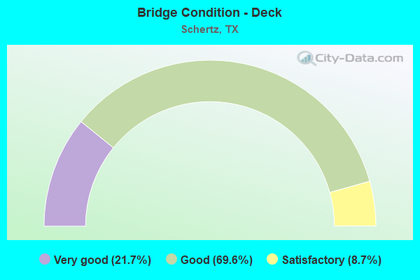
- Bridge Condition - Deck
- 21.7%Very good
- 69.6%Good
- 8.7%Satisfactory
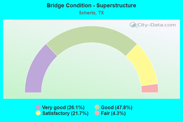
- Bridge Condition - Superstructure
- 26.1%Very good
- 47.8%Good
- 21.7%Satisfactory
- 4.3%Fair
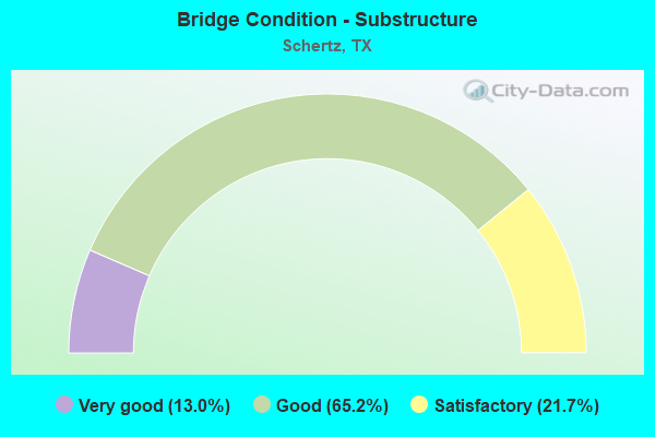
- Bridge Condition - Substructure
- 13.0%Very good
- 65.2%Good
- 21.7%Satisfactory
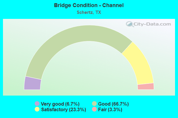
- Bridge Condition - Channel
- 6.7%Very good
- 66.7%Good
- 23.3%Satisfactory
- 3.3%Fair
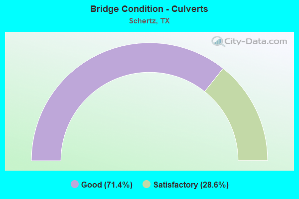
- Bridge Condition - Culverts
- 71.4%Good
- 28.6%Satisfactory
Find on map >> Show street view
Structure Number: 15015000250201, Location: 1.01 MI E OF FM 1518 (Lat: 29.493558, Lng: -98.208017), Route carried "on" structure: ServiceOther road 10, Year Built: 1932, Status: Open, Structure Length: 3.47m (11.38ft), Average Daily Traffic: 431 (year 2020), Truck Traffic: 10%, Average Future Daily Traffic: 1,070 (year 2036), Design Load: H 15, Features Intersected: WOMAN HOLLERING CREEK
Minimum Vertical Clearance: 30+ m (98+ ft), Kilometerpoint: 32.636, Lanes on structure: 2, Owner: State Highway Agency, Approaching Roadway Width: 7.3m (24.0ft), Material/Design: Concrete, Design/Construction: Tee Beam, Number Of Spans In Main Unit: 4, Length of Maximum Span: 8.5m (27.9ft), Curb-To-Curb Width: 11.8m (38.7ft), Out-to-Out Width: 13.1m (43.0ft)
Condition: Deck: Good, Superstructure: Satisfactory, Substructure: Satisfactory, Channel: Satisfactory, Operating Rating: 68.0 metric tons, Method Used To Determine Operating Rating: Load Factor (LF), Inventory Rating: 40.8 metric tons, Method Used To Determine Inventory Rating: Load Factor (LF), Structural Evaluation: Equal to present minimum criteria, Deck Geometry: Better than present minimum criteria, Waterway Adequacy: Better than present minimum criteria, Approach Roadway Alignment: Equal to present desirable criteria, Designated Inspection Frequency: Every 24 months, Inspection Date: June 2020, Deck Structure Type: Concrete Cast-file-Place, Wearing Surface/Protective System: Wearing Surface: Bituminous
Find on map >> Show street view
Structure Number: 150150002502011, Location: BEXAR-GUADALUPE CO LINE (Lat: 29.501411, Lng: -98.186439), Route carried "on" structure: ServiceInterstate 10, Year Built: 1933, Status: Not yet open, Structure Length: 13.23m (43.41ft), Average Daily Traffic: 840 (year 2010), Truck Traffic: 3%, Average Future Daily Traffic: 1,370 (year 2030), Design Load: H 15, Features Intersected: CIBOLO CREEK
Minimum Vertical Clearance: 4.83m (15.85ft), Kilometerpoint: 34.797, Lanes on structure: 1, Owner: State Highway Agency, Approaching Roadway Width: 7.3m (24.0ft), Material/Design: Steel, Design/Construction: Truss - Thru, Number Of Spans In Main Unit: 1, Number Of Approach Spans: 6, Length of Maximum Span: 36.6m (120.1ft), Curb-To-Curb Width: 7.2m (23.6ft), Out-to-Out Width: 7.9m (25.9ft)
Condition: Deck: Satisfactory, Superstructure: Fair, Substructure: Satisfactory, Channel: Good, Operating Rating: 49.0 metric tons, Method Used To Determine Operating Rating: Load Factor (LF), Inventory Rating: 29.9 metric tons, Method Used To Determine Inventory Rating: Load Factor (LF), Structural Evaluation: Somewhat better than minimum adequacy, Deck Geometry: Meets minimum limits, Waterway Adequacy: Better than present minimum criteria, Approach Roadway Alignment: Equal to present desirable criteria, Length Of Structure Improvement: 14.39m (47.21ft), Designated Inspection Frequency: Every 24 months, Critical Feature Inspection Frequency: Every 24 months, Inspection Date: August 2021, Critical Feature Inspection Date: September 2021, Bridge Improvement Cost: $629,000, Roadway Improvement Cost: $157,000, Total Project Cost: $786,000, Deck Structure Type: Concrete Cast-file-Place, Wearing Surface/Protective System: Wearing Surface: Monolithic Concrete
Find on map >> Show street view
Structure Number: 150150002502108, Location: 1.44 MI E OF LP 1604 (Lat: 29.472775, Lng: -98.269894), Route carried "on" structure: ServiceInterstate 10, Year Built: 1962, Year Reconstructed: 2008, Status: Open, Structure Length: 6.52m (21.39ft), Average Daily Traffic: 440 (year 2010), Truck Traffic: 3%, Average Future Daily Traffic: 420 (year 2030), Design Load: H 20, Features Intersected: SALITRILLO CREEK
Minimum Vertical Clearance: 30+ m (98+ ft), Kilometerpoint: 26.174, Lanes on structure: 2, Owner: State Highway Agency, Approaching Roadway Width: 9.4m (30.8ft), Skew: 3 degrees, Material/Design: Concrete, Design/Construction: Stringer/Multi-beam, Number Of Spans In Main Unit: 5, Length of Maximum Span: 13.1m (43.0ft), Curb-To-Curb Width: 9.4m (30.8ft), Out-to-Out Width: 10.5m (34.4ft)
Condition: Deck: Good, Superstructure: Good, Substructure: Good, Channel: Good, Operating Rating: 47.2 metric tons, Method Used To Determine Operating Rating: Load Factor (LF), Inventory Rating: 28.1 metric tons, Method Used To Determine Inventory Rating: Load Factor (LF), Structural Evaluation: Better than present minimum criteria, Deck Geometry: Equal to present minimum criteria, Waterway Adequacy: Equal to present minimum criteria, Approach Roadway Alignment: Equal to present desirable criteria, Length Of Structure Improvement: 6.52m (21.39ft), Designated Inspection Frequency: Every 24 months, Inspection Date: May 2020, Bridge Improvement Cost: $11,000, Roadway Improvement Cost: $3,000, Total Project Cost: $14,000, Deck Structure Type: Concrete Cast-file-Place, Wearing Surface/Protective System: Wearing Surface: Bituminous
Find on map >> Show street view
Structure Number: 150150002502115, Location: 2.73 MI E OF LP 1604 (Lat: 29.479456, Lng: -98.249872), Route carried "on" structure: Interstate 10, Year Built: 1931, Year Reconstructed: 1962, Status: Open, Structure Length: 0.79m (2.59ft), Average Daily Traffic: 54,755 (year 2019), Truck Traffic: 21%, Average Future Daily Traffic: 53,150 (year 2033), Design Load: H 15, Features Intersected: DRAIN
Minimum Vertical Clearance: 30+ m (98+ ft), Kilometerpoint: 28.268, Lanes on structure: 8, Owner: State Highway Agency, Approaching Roadway Width: 37.8m (124.0ft), Skew: 19 degrees, Material/Design: Concrete, Design/Construction: Culvert, Number Of Spans In Main Unit: 3, Length of Maximum Span: 1.8m (5.9ft)
Condition: Channel: Satisfactory, Culverts: Satisfactory, Operating Rating: 39.9 metric tons, Method Used To Determine Operating Rating: Load Factor (LF), Inventory Rating: 23.6 metric tons, Method Used To Determine Inventory Rating: Load Factor (LF), Structural Evaluation: Somewhat better than minimum adequacy, Waterway Adequacy: Equal to present minimum criteria, Approach Roadway Alignment: Equal to present desirable criteria, Designated Inspection Frequency: Every 24 months, Inspection Date: May 2020
Find on map >> Show street view
Structure Number: 150150002502125, Location: 1.01 MI E OF FM 1518 (Lat: 29.493392, Lng: -98.207939), Route carried "on" structure: Interstate 10, Year Built: 1962, Status: Open, Structure Length: 3.66m (12.01ft), Average Daily Traffic: 25,460 (year 2017), Truck Traffic: 17%, Average Future Daily Traffic: 29,085 (year 2036), Design Load: HS 20, Features Intersected: WOMAN HOLLERING CREEK
Minimum Vertical Clearance: 30+ m (98+ ft), Kilometerpoint: 32.636, Lanes on structure: 2, Owner: State Highway Agency, Approaching Roadway Width: 11.6m (38.1ft), Material/Design: Concrete, Design/Construction: Stringer/Multi-beam, Number Of Spans In Main Unit: 3, Length of Maximum Span: 12.2m (40.0ft), Curb-To-Curb Width: 11.3m (37.1ft), Out-to-Out Width: 12.1m (39.7ft)
Condition: Deck: Good, Superstructure: Satisfactory, Substructure: Good, Channel: Satisfactory, Operating Rating: 54.4 metric tons, Method Used To Determine Operating Rating: Load Factor (LF), Inventory Rating: 32.7 metric tons, Method Used To Determine Inventory Rating: Load Factor (LF), Structural Evaluation: Equal to present minimum criteria, Deck Geometry: Somewhat better than minimum adequacy, Waterway Adequacy: Equal to present minimum criteria, Approach Roadway Alignment: Equal to present desirable criteria, Designated Inspection Frequency: Every 24 months, Inspection Date: June 2020, Deck Structure Type: Concrete Cast-file-Place, Wearing Surface/Protective System: Wearing Surface: Bituminous
Find on map >> Show street view
Structure Number: 150150002502126, Location: 1.01 MI E OF FM 1518 (Lat: 29.493225, Lng: -98.207869), Route carried "on" structure: Interstate 10, Year Built: 1962, Status: Open, Structure Length: 3.66m (12.01ft), Average Daily Traffic: 23,519 (year 2017), Truck Traffic: 17%, Average Future Daily Traffic: 29,085 (year 2036), Design Load: HS 20, Features Intersected: WOMAN HOLLERING CREEK
Minimum Vertical Clearance: 30+ m (98+ ft), Kilometerpoint: 32.636, Lanes on structure: 2, Owner: State Highway Agency, Approaching Roadway Width: 11.6m (38.1ft), Material/Design: Concrete, Design/Construction: Stringer/Multi-beam, Number Of Spans In Main Unit: 3, Length of Maximum Span: 12.2m (40.0ft), Curb-To-Curb Width: 11.3m (37.1ft), Out-to-Out Width: 12.1m (39.7ft)
Condition: Deck: Good, Superstructure: Satisfactory, Substructure: Satisfactory, Channel: Satisfactory, Operating Rating: 54.4 metric tons, Method Used To Determine Operating Rating: Load Factor (LF), Inventory Rating: 32.7 metric tons, Method Used To Determine Inventory Rating: Load Factor (LF), Structural Evaluation: Equal to present minimum criteria, Deck Geometry: Somewhat better than minimum adequacy, Waterway Adequacy: Equal to present minimum criteria, Approach Roadway Alignment: Equal to present desirable criteria, Designated Inspection Frequency: Every 24 months, Inspection Date: June 2020, Deck Structure Type: Concrete Cast-file-Place, Wearing Surface/Protective System: Wearing Surface: Bituminous
Find on map >> Show street view
Structure Number: 150150002502127, Location: 1.82 MI E OF FM 1518 (Lat: 29.497575, Lng: -98.195575), Route carried "on" structure: State highway 2538, Year Built: 1962, Status: Open, Structure Length: 7.01m (23.00ft), Average Daily Traffic: 2,034 (year 2016), Truck Traffic: 6%, Average Future Daily Traffic: 2,856 (year 2036), Design Load: H 15, Features Intersected: IH 10
Minimum Vertical Clearance: 30+ m (98+ ft), Kilometerpoint: 16.090, Lanes on structure: 2, Lanes under structure: 4, Owner: State Highway Agency, Approaching Roadway Width: 7.3m (24.0ft), Skew: 2 degrees, Material/Design: Prestressed concrete, Design/Construction: Stringer/Multi-beam, Number Of Spans In Main Unit: 4, Length of Maximum Span: 19.8m (65.0ft), Curb-To-Curb Width: 7.3m (24.0ft), Out-to-Out Width: 7.8m (25.6ft)
Condition: Deck: Satisfactory, Superstructure: Good, Substructure: Good, Operating Rating: 62.6 metric tons, Method Used To Determine Operating Rating: Load Factor (LF), Inventory Rating: 23.6 metric tons, Method Used To Determine Inventory Rating: Load Factor (LF), Structural Evaluation: Equal to present minimum criteria, Deck Geometry: High priority of replacement, Underclear: Equal to present minimum criteria, Approach Roadway Alignment: Equal to present desirable criteria, Length Of Structure Improvement: 7.01m (23.00ft), Designated Inspection Frequency: Every 24 months, Inspection Date: June 2020, Bridge Improvement Cost: $11,000, Roadway Improvement Cost: $3,000, Total Project Cost: $14,000, Deck Structure Type: Concrete Cast-file-Place, Wearing Surface/Protective System: Wearing Surface: Bituminous
Find on map >> Show street view
Structure Number: 150150046502194, Location: 1.67 MI N OF !H 10 (Lat: 29.508611, Lng: -98.237083), Route carried "on" structure: State highway 1518, Year Built: 2014, Status: Open, Structure Length: 7.01m (23.00ft), Average Daily Traffic: 8,020 (year 2020), Truck Traffic: 5%, Average Future Daily Traffic: 11,000 (year 2033), Design Load: HL 93, Features Intersected: WOMAN HOLLERING CREEK
Minimum Vertical Clearance: 30+ m (98+ ft), Kilometerpoint: 0.000, Lanes on structure: 2, Owner: State Highway Agency, Approaching Roadway Width: 13.4m (44.0ft), Skew: 1 degrees, Material/Design: Concrete continuous, Design/Construction: Slab, Number Of Spans In Main Unit: 8, Length of Maximum Span: 9.1m (29.9ft), Curb-To-Curb Width: 13.4m (44.0ft), Out-to-Out Width: 14.0m (45.9ft)
Condition: Deck: Good, Superstructure: Good, Substructure: Good, Channel: Very good, Operating Rating: 54.4 metric tons, Method Used To Determine Operating Rating: Assigned ratings based on Load and Resistance Factor Design (LRFD) reported in metric tons, Inventory Rating: 32.7 metric tons, Method Used To Determine Inventory Rating: Assigned ratings based on Load and Resistance Factor Design (LRFD) reported in metric tons, Structural Evaluation: Better than present minimum criteria, Deck Geometry: Equal to present minimum criteria, Waterway Adequacy: Superior to present desirable criteria, Approach Roadway Alignment: Equal to present desirable criteria, Designated Inspection Frequency: Every 24 months, Inspection Date: May 2020, Deck Structure Type: Concrete Cast-file-Place
Find on map >> Show street view
Structure Number: 150150AA9019001, Location: 0.4 Miles NE FM 1518 (Lat: 29.502183, Lng: -98.225217), Route carried "on" structure: County highway , Year Built: 2012, Status: Open, Structure Length: 3.32m (10.89ft), Average Daily Traffic: 410 (year 2020), Truck Traffic: 1%, Average Future Daily Traffic: 100 (year 2033), Design Load: HL 93, Features Intersected: WOMAN HOLLERING CREEK, Facility Carried by Structure: TRAINER HALE ROAD
Minimum Vertical Clearance: 30+ m (98+ ft), Kilometerpoint: 0.644, Lanes on structure: 2, Owner: County Highway Agency, Approaching Roadway Width: 6.7m (22.0ft), Skew: 1 degrees, Material/Design: Concrete, Design/Construction: Culvert, Number Of Spans In Main Unit: 10, Length of Maximum Span: 3.0m (9.8ft), Curb-To-Curb Width: 9.6m (31.5ft), Out-to-Out Width: 10.4m (34.1ft)
Condition: Channel: Good, Culverts: Good, Operating Rating: 54.4 metric tons, Method Used To Determine Operating Rating: Assigned ratings based on Load and Resistance Factor Design (LRFD) reported in metric tons, Inventory Rating: 32.7 metric tons, Method Used To Determine Inventory Rating: Assigned ratings based on Load and Resistance Factor Design (LRFD) reported in metric tons, Structural Evaluation: Better than present minimum criteria, Deck Geometry: Equal to present minimum criteria, Waterway Adequacy: Equal to present minimum criteria, Approach Roadway Alignment: Equal to present desirable criteria, Designated Inspection Frequency: Every 24 months, Inspection Date: September 2021, Deck Structure Type: Concrete Cast-file-Place, Wearing Surface/Protective System: Wearing Surface: Bituminous
Find on map >> Show street view
Structure Number: 150150R00480001, Location: 1.50 MI NE OF LP 1604 (Lat: 29.514922, Lng: -98.266606), Route carried "on" structure: City street , Year Built: 2006, Status: Open, Structure Length: 2.93m (9.61ft), Average Daily Traffic: 4,904 (year 2020), Truck Traffic: 1%, Average Future Daily Traffic: 3,000 (year 2033), Design Load: HS 20, Features Intersected: WOMAN HOLLERING CREEK, Facility Carried by Structure: LOWER SEGUIN RD
Minimum Vertical Clearance: 30+ m (98+ ft), Kilometerpoint: 2.414, Lanes on structure: 2, Owner: City or Municipal Highway Agency, Approaching Roadway Width: 11.9m (39.0ft), Skew: 3 degrees, Material/Design: Concrete, Design/Construction: Culvert, Number Of Spans In Main Unit: 7, Length of Maximum Span: 3.4m (11.2ft), Curb-To-Curb Width: 11.9m (39.0ft), Out-to-Out Width: 12.8m (42.0ft)
Condition: Channel: Good, Culverts: Good, Operating Rating: 54.4 metric tons, Method Used To Determine Operating Rating: Assigned ratings based on Load and Resistance Factor Design (LRFD) reported in metric tons, Inventory Rating: 32.7 metric tons, Method Used To Determine Inventory Rating: Assigned ratings based on Load and Resistance Factor Design (LRFD) reported in metric tons, Structural Evaluation: Better than present minimum criteria, Deck Geometry: Somewhat better than minimum adequacy, Waterway Adequacy: Superior to present desirable criteria, Approach Roadway Alignment: Equal to present desirable criteria, Designated Inspection Frequency: Every 24 months, Inspection Date: May 2021, Deck Structure Type: Concrete Cast-file-Place, Wearing Surface/Protective System: Wearing Surface: Bituminous
Find on map >> Show street view
Structure Number: 150460001605019, Location: 90 FT N OF SCHWAB ROAD (Lat: 29.640067, Lng: -98.211369), Route carried "on" structure: Interstate 35, Year Built: 1933, Year Reconstructed: 1965, Status: Open, Structure Length: 0.64m (2.10ft), Average Daily Traffic: 105,026 (year 2020), Truck Traffic: 15%, Average Future Daily Traffic: 150,990 (year 2033), Design Load: H 15, Features Intersected: DRAW
Minimum Vertical Clearance: 30+ m (98+ ft), Kilometerpoint: 5.662, Lanes on structure: 10, Owner: State Highway Agency, Approaching Roadway Width: 58.5m (191.9ft), Skew: 30 degrees, Material/Design: Concrete, Design/Construction: Culvert, Number Of Spans In Main Unit: 2, Length of Maximum Span: 3.0m (9.8ft)
Condition: Channel: Good, Culverts: Good, Operating Rating: 39.9 metric tons, Method Used To Determine Operating Rating: Load Factor (LF), Inventory Rating: 23.6 metric tons, Method Used To Determine Inventory Rating: Load Factor (LF), Structural Evaluation: Somewhat better than minimum adequacy, Waterway Adequacy: Equal to present minimum criteria, Approach Roadway Alignment: Equal to present desirable criteria, Designated Inspection Frequency: Every 24 months, Inspection Date: June 2020
Find on map >> Show street view
Structure Number: 15046000160502, Location: 8.9 MI SW OF FM 725 (Lat: 29.627903, Lng: -98.235150), Route carried "on" structure: Interstate 35, Year Built: 1933, Year Reconstructed: 1998, Status: Open, Structure Length: 1.62m (5.31ft), Average Daily Traffic: 105,026 (year 2020), Truck Traffic: 15%, Average Future Daily Traffic: 150,990 (year 2033), Design Load: H 15, Features Intersected: DRAW
Minimum Vertical Clearance: 30+ m (98+ ft), Kilometerpoint: 3.019, Lanes on structure: 10, Owner: State Highway Agency, Approaching Roadway Width: 62.8m (206.0ft), Skew: 39 degrees, Material/Design: Concrete, Design/Construction: Culvert, Number Of Spans In Main Unit: 8, Length of Maximum Span: 1.8m (5.9ft)
Condition: Channel: Satisfactory, Culverts: Satisfactory, Operating Rating: 39.9 metric tons, Method Used To Determine Operating Rating: Load Factor (LF), Inventory Rating: 23.6 metric tons, Method Used To Determine Inventory Rating: Load Factor (LF), Structural Evaluation: Somewhat better than minimum adequacy, Waterway Adequacy: Equal to present minimum criteria, Approach Roadway Alignment: Equal to present desirable criteria, Designated Inspection Frequency: Every 24 months, Inspection Date: June 2020, Deck Structure Type: Concrete Precast Panels, Wearing Surface/Protective System: Wearing Surface: Bituminous
Find on map >> Show street view
Structure Number: 150460001605136, Location: 0.4 MI N OF GUADALUPE C/L (Lat: 29.616750, Lng: -98.256928), Route carried "on" structure: State highway 482, Year Built: 1965, Year Reconstructed: 1998, Status: Open, Structure Length: 7.07m (23.20ft), Average Daily Traffic: 1,460 (year 2013), Truck Traffic: 7%, Average Future Daily Traffic: 2,050 (year 2033), Design Load: H 20, Features Intersected: IH 35
Minimum Vertical Clearance: 30+ m (98+ ft), Kilometerpoint: 0.034, Lanes on structure: 2, Lanes under structure: 6, Owner: State Highway Agency, Approaching Roadway Width: 13.1m (43.0ft), Material/Design: Prestressed concrete, Design/Construction: Stringer/Multi-beam, Number Of Spans In Main Unit: 4, Length of Maximum Span: 19.8m (65.0ft), Curb-To-Curb Width: 13.1m (43.0ft), Out-to-Out Width: 14.0m (45.9ft)
Condition: Deck: Good, Superstructure: Very good, Substructure: Good, Operating Rating: 68.0 metric tons, Method Used To Determine Operating Rating: Load Factor (LF), Inventory Rating: 34.5 metric tons, Method Used To Determine Inventory Rating: Load Factor (LF), Structural Evaluation: Better than present minimum criteria, Deck Geometry: Better than present minimum criteria, Underclear: Meets minimum limits, Approach Roadway Alignment: Equal to present desirable criteria, Designated Inspection Frequency: Every 24 months, Inspection Date: June 2020, Deck Structure Type: Concrete Cast-file-Place, Wearing Surface/Protective System: Wearing Surface: Bituminous
Find on map >> Show street view
Structure Number: 150460001605138, Location: 3.4 MI N OF GUADALUPE C/L (Lat: 29.639867, Lng: -98.211869), Route carried "on" structure: Interstate 35, Year Built: 1965, Year Reconstructed: 1996, Status: Open, Structure Length: 3.69m (12.11ft), Average Daily Traffic: 58,940 (year 2019), Truck Traffic: 15%, Average Future Daily Traffic: 75,490 (year 2033), Design Load: HS 20, Features Intersected: SCHWAB ROAD
Minimum Vertical Clearance: 30+ m (98+ ft), Kilometerpoint: 5.615, Lanes on structure: 3, Lanes under structure: 2, Base Highway Network: Yes, Owner: State Highway Agency, Approaching Roadway Width: 18.3m (60.0ft), Material/Design: Prestressed concrete, Design/Construction: Stringer/Multi-beam, Number Of Spans In Main Unit: 3, Length of Maximum Span: 12.2m (40.0ft), Curb-To-Curb Width: 18.1m (59.4ft), Out-to-Out Width: 18.9m (62.0ft)
Condition: Deck: Good, Superstructure: Good, Substructure: Good, Operating Rating: 61.7 metric tons, Method Used To Determine Operating Rating: Load Factor (LF), Inventory Rating: 37.2 metric tons, Method Used To Determine Inventory Rating: Load Factor (LF), Structural Evaluation: Better than present minimum criteria, Deck Geometry: Better than present minimum criteria, Underclear: High priority of corrective action, Approach Roadway Alignment: Equal to present desirable criteria, Length Of Structure Improvement: 3.69m (12.11ft), Designated Inspection Frequency: Every 24 months, Inspection Date: June 2020, Deck Structure Type: Concrete Cast-file-Place, Wearing Surface/Protective System: Wearing Surface: Bituminous
Find on map >> Show street view
Structure Number: 150460001605139, Location: 3.4 MI N OF GUADALUPE C/L (Lat: 29.639789, Lng: -98.211819), Route carried "on" structure: Interstate 35, Year Built: 1965, Year Reconstructed: 1996, Status: Open, Structure Length: 3.69m (12.11ft), Average Daily Traffic: 61,780 (year 2019), Truck Traffic: 15%, Average Future Daily Traffic: 75,490 (year 2033), Design Load: HS 20, Features Intersected: SCHWAB RD
Minimum Vertical Clearance: 30+ m (98+ ft), Kilometerpoint: 5.615, Lanes on structure: 3, Lanes under structure: 2, Owner: State Highway Agency, Approaching Roadway Width: 18.3m (60.0ft), Material/Design: Prestressed concrete, Design/Construction: Stringer/Multi-beam, Number Of Spans In Main Unit: 3, Length of Maximum Span: 12.2m (40.0ft), Curb-To-Curb Width: 18.1m (59.4ft), Out-to-Out Width: 18.9m (62.0ft)
Condition: Deck: Good, Superstructure: Good, Substructure: Good, Operating Rating: 61.7 metric tons, Method Used To Determine Operating Rating: Load Factor (LF), Inventory Rating: 37.2 metric tons, Method Used To Determine Inventory Rating: Load Factor (LF), Structural Evaluation: Better than present minimum criteria, Deck Geometry: Better than present minimum criteria, Underclear: High priority of corrective action, Approach Roadway Alignment: Equal to present desirable criteria, Designated Inspection Frequency: Every 24 months, Inspection Date: June 2020, Deck Structure Type: Concrete Cast-file-Place, Wearing Surface/Protective System: Wearing Surface: Bituminous
Find on map >> Show street view
Structure Number: 150460001605456, Location: FM 1103 at IH 35 (Lat: 29.625236, Lng: -98.239672), Route carried "on" structure: State highway 1103, Year Built: 2019, Status: Open, Structure Length: 6.71m (22.01ft), Average Daily Traffic: 17,600 (year 2017), Average Future Daily Traffic: 28,600 (year 2037), Design Load: HL 93, Features Intersected: IH 35
Minimum Vertical Clearance: 0.00m, Kilometerpoint: 0.000, Lanes on structure: 5, Lanes under structure: 6, Owner: State Highway Agency, Approaching Roadway Width: 25.0m (82.0ft), Material/Design: Prestressed concrete, Design/Construction: Stringer/Multi-beam, Number Of Spans In Main Unit: 2, Length of Maximum Span: 33.5m (109.9ft), Curb or Sidewalk Widths: Left: 2.0m (6.6ft), Right: 2.0m (6.6ft), Curb-To-Curb Width: 25.0m (82.0ft), Out-to-Out Width: 29.6m (97.1ft)
Condition: Deck: Good, Superstructure: Very good, Substructure: Very good, Operating Rating: 54.4 metric tons, Method Used To Determine Operating Rating: Assigned ratings based on Load and Resistance Factor Design (LRFD) reported in metric tons, Inventory Rating: 32.7 metric tons, Method Used To Determine Inventory Rating: Assigned ratings based on Load and Resistance Factor Design (LRFD) reported in metric tons, Structural Evaluation: Equal to present desirable criteria, Deck Geometry: Superior to present desirable criteria, Underclear: Meets minimum limits, Approach Roadway Alignment: Equal to present desirable criteria, Designated Inspection Frequency: Every 24 months, Inspection Date: June 2020, Deck Structure Type: Concrete Cast-file-Place, Wearing Surface/Protective System: Deck Protection: Epoxy Coated Reinforcing
Find on map >> Show street view
Structure Number: 150460001605457, Location: 0 (Lat: 29.625936, Lng: -98.239783), Route carried "on" structure: ServiceState highway 1103, Year Built: 2019, Status: Open, Structure Length: 6.71m (22.01ft), Average Future Daily Traffic: 1 (year 1900), Design Load: HL 93, Features Intersected: IH 35, Facility Carried by Structure: IH 35 SBFR T/A
Minimum Vertical Clearance: 0.00m, Kilometerpoint: 0.000, Lanes on structure: 1, Lanes under structure: 6, Owner: State Highway Agency, Approaching Roadway Width: 9.1m (29.9ft), Material/Design: Prestressed concrete, Design/Construction: Stringer/Multi-beam, Number Of Spans In Main Unit: 2, Length of Maximum Span: 33.5m (109.9ft), Curb-To-Curb Width: 9.1m (29.9ft), Out-to-Out Width: 9.8m (32.2ft)
Condition: Deck: Very good, Superstructure: Very good, Substructure: Very good, Operating Rating: 54.4 metric tons, Method Used To Determine Operating Rating: Assigned ratings based on Load and Resistance Factor Design (LRFD) reported in metric tons, Inventory Rating: 32.7 metric tons, Method Used To Determine Inventory Rating: Assigned ratings based on Load and Resistance Factor Design (LRFD) reported in metric tons, Structural Evaluation: Equal to present desirable criteria, Deck Geometry: Better than present minimum criteria, Underclear: Meets minimum limits, Approach Roadway Alignment: Equal to present desirable criteria, Designated Inspection Frequency: Every 24 months, Inspection Date: June 2020, Deck Structure Type: Concrete Precast Panels, Wearing Surface/Protective System: Deck Protection: Epoxy Coated Reinforcing
Find on map >> Show street view
Structure Number: 150460001605458, Location: FM 1103 at IH 35 (Lat: 29.625292, Lng: -98.239700), Route carried "on" structure: ServiceState highway 1103, Year Built: 2019, Status: Open, Structure Length: 6.71m (22.01ft), Average Future Daily Traffic: 1 (year 1900), Design Load: HL 93, Features Intersected: IH 35
Minimum Vertical Clearance: 0.00m, Kilometerpoint: 0.000, Lanes on structure: 1, Lanes under structure: 6, Owner: State Highway Agency, Approaching Roadway Width: 9.1m (29.9ft), Material/Design: Steel, Design/Construction: Stringer/Multi-beam, Number Of Spans In Main Unit: 3, Length of Maximum Span: 33.5m (109.9ft), Curb-To-Curb Width: 9.1m (29.9ft), Out-to-Out Width: 9.8m (32.2ft)
Condition: Deck: Very good, Superstructure: Very good, Substructure: Very good, Operating Rating: 54.4 metric tons, Method Used To Determine Operating Rating: Assigned ratings based on Load and Resistance Factor Design (LRFD) reported in metric tons, Inventory Rating: 32.7 metric tons, Method Used To Determine Inventory Rating: Assigned ratings based on Load and Resistance Factor Design (LRFD) reported in metric tons, Structural Evaluation: Equal to present desirable criteria, Deck Geometry: Better than present minimum criteria, Underclear: Meets minimum limits, Approach Roadway Alignment: Equal to present desirable criteria, Designated Inspection Frequency: Every 24 months, Inspection Date: June 2020, Deck Structure Type: Concrete Cast-file-Place, Wearing Surface/Protective System: Deck Protection: Epoxy Coated Reinforcing
Find on map >> Show street view
Structure Number: 150460143302003, Location: 1.0 MI FROM FM 482 (Lat: 29.632231, Lng: -98.262569), Route carried "on" structure: State highway 2252, Year Built: 1961, Status: Open, Structure Length: 0.76m (2.49ft), Average Daily Traffic: 4,379 (year 2020), Truck Traffic: 5%, Average Future Daily Traffic: 5,480 (year 2033), Design Load: HS 20, Features Intersected: BREMER CREEK
Minimum Vertical Clearance: 30+ m (98+ ft), Kilometerpoint: 3.082, Lanes on structure: 2, Owner: State Highway Agency, Approaching Roadway Width: 7.9m (25.9ft), Material/Design: Concrete, Design/Construction: Culvert, Number Of Spans In Main Unit: 3, Length of Maximum Span: 2.4m (7.9ft)
Condition: Channel: Satisfactory, Culverts: Good, Operating Rating: 39.9 metric tons, Method Used To Determine Operating Rating: Load Factor (LF), Inventory Rating: 23.6 metric tons, Method Used To Determine Inventory Rating: Load Factor (LF), Structural Evaluation: Equal to present minimum criteria, Waterway Adequacy: Equal to present minimum criteria, Approach Roadway Alignment: Equal to present desirable criteria, Length Of Structure Improvement: 0.79m (2.59ft), Designated Inspection Frequency: Every 24 months, Inspection Date: June 2020
Find on map >> Show street view
Structure Number: 150460310701143, Location: 0.65 M NW of Guadalupe CL (Lat: 29.614933, Lng: -98.285183), Route carried "on" structure: State highway 3009, Year Built: 2011, Status: Open, Structure Length: 7.92m (25.98ft), Average Daily Traffic: 19,800 (year 2010), Truck Traffic: 15%, Average Future Daily Traffic: 28,300 (year 2030), Design Load: HL 93, Features Intersected: UPRR (EAST X-ING)
Minimum Vertical Clearance: 30+ m (98+ ft), Kilometerpoint: 37.033, Lanes on structure: 4, Owner: State Highway Agency, Approaching Roadway Width: 17.7m (58.1ft), Skew: 20 degrees, Material/Design: Prestressed concrete, Design/Construction: Stringer/Multi-beam, Number Of Spans In Main Unit: 1, Number Of Approach Spans: 2, Length of Maximum Span: 36.6m (120.1ft), Curb or Sidewalk Widths: Left: 1.8m (5.9ft), Right: 1.8m (5.9ft), Curb-To-Curb Width: 17.9m (58.7ft), Out-to-Out Width: 27.4m (89.9ft)
Condition: Deck: Good, Superstructure: Very good, Substructure: Good, Operating Rating: 54.4 metric tons, Method Used To Determine Operating Rating: Assigned ratings based on Load and Resistance Factor Design (LRFD) reported in metric tons, Inventory Rating: 32.7 metric tons, Method Used To Determine Inventory Rating: Assigned ratings based on Load and Resistance Factor Design (LRFD) reported in metric tons, Structural Evaluation: Better than present minimum criteria, Deck Geometry: Somewhat better than minimum adequacy, Underclear: Superior to present desirable criteria, Approach Roadway Alignment: Equal to present desirable criteria, Designated Inspection Frequency: Every 24 months, Inspection Date: June 2020, Deck Structure Type: Concrete Precast Panels
Find on map >> Show street view
Structure Number: 150460310701144, Location: 1.1 MI NW of Guadalupe CL (Lat: 29.620933, Lng: -98.288933), Route carried "on" structure: State highway 3009, Year Built: 2011, Status: Open, Structure Length: 8.69m (28.51ft), Average Daily Traffic: 18,991 (year 2020), Truck Traffic: 15%, Average Future Daily Traffic: 28,000 (year 2030), Design Load: HL 93, Features Intersected: UPRR (WEST X-ING)
Minimum Vertical Clearance: 30+ m (98+ ft), Kilometerpoint: 36.278, Lanes on structure: 4, Owner: State Highway Agency, Approaching Roadway Width: 17.7m (58.1ft), Skew: 21 degrees, Material/Design: Prestressed concrete, Design/Construction: Stringer/Multi-beam, Number Of Spans In Main Unit: 1, Number Of Approach Spans: 2, Length of Maximum Span: 37.8m (124.0ft), Curb or Sidewalk Widths: Left: 1.8m (5.9ft), Right: 1.8m (5.9ft), Curb-To-Curb Width: 17.9m (58.7ft), Out-to-Out Width: 27.4m (89.9ft)
Condition: Deck: Good, Superstructure: Good, Substructure: Good, Operating Rating: 54.4 metric tons, Method Used To Determine Operating Rating: Assigned ratings based on Load and Resistance Factor Design (LRFD) reported in metric tons, Inventory Rating: 32.7 metric tons, Method Used To Determine Inventory Rating: Assigned ratings based on Load and Resistance Factor Design (LRFD) reported in metric tons, Structural Evaluation: Better than present minimum criteria, Deck Geometry: Somewhat better than minimum adequacy, Underclear: Superior to present desirable criteria, Approach Roadway Alignment: Equal to present desirable criteria, Designated Inspection Frequency: Every 24 months, Inspection Date: June 2020, Deck Structure Type: Concrete Precast Panels
Find on map >> Show street view
Structure Number: 150460310701145, Location: .55 MI NW of Guadalupe CL (Lat: 29.613783, Lng: -98.284350), Route carried "on" structure: ServiceState highway 3009, Year Built: 2011, Status: Open, Structure Length: 1.01m (3.31ft), Average Daily Traffic: 19,800 (year 2010), Truck Traffic: 15%, Average Future Daily Traffic: 28,300 (year 2030), Design Load: HS 20, Features Intersected: DRY COMAL CREEK TRIB
Minimum Vertical Clearance: 30+ m (98+ ft), Kilometerpoint: 37.211, Lanes on structure: 6, Owner: State Highway Agency, Approaching Roadway Width: 34.1m (111.9ft), Skew: 3 degrees, Material/Design: Concrete, Design/Construction: Culvert, Number Of Spans In Main Unit: 2, Length of Maximum Span: 3.7m (12.1ft)
Condition: Channel: Satisfactory, Culverts: Satisfactory, Operating Rating: 54.4 metric tons, Method Used To Determine Operating Rating: Assigned rating based on Load Factor Design (LFD) reported in metric tons, Inventory Rating: 32.7 metric tons, Method Used To Determine Inventory Rating: Assigned rating based on Load Factor Design (LFD) reported in metric tons, Structural Evaluation: Equal to present minimum criteria, Waterway Adequacy: Superior to present desirable criteria, Approach Roadway Alignment: Equal to present desirable criteria, Designated Inspection Frequency: Every 24 months, Inspection Date: June 2020
Find on map >> Show street view
Structure Number: 150460AA0736001, Location: 0.02 N OF NACOGDOCHES RD (Lat: 29.646303, Lng: -98.240189), Route carried "on" structure: County highway , Year Built: 2011, Status: Open, Structure Length: 1.01m (3.31ft), Average Daily Traffic: 697 (year 2015), Average Future Daily Traffic: 400 (year 2033), Design Load: HS 20, Features Intersected: DRY COMAL CREEK, Facility Carried by Structure: CR 736(COYOTE RUN)
Minimum Vertical Clearance: 30+ m (98+ ft), Kilometerpoint: 0.032, Lanes on structure: 2, Owner: County Highway Agency, Approaching Roadway Width: 8.5m (27.9ft), Material/Design: Concrete, Design/Construction: Culvert, Number Of Spans In Main Unit: 3, Length of Maximum Span: 3.0m (9.8ft), Curb-To-Curb Width: 9.0m (29.5ft), Out-to-Out Width: 9.8m (32.2ft)
Condition: Channel: Good, Culverts: Good, Operating Rating: 54.4 metric tons, Method Used To Determine Operating Rating: Assigned rating based on Load Factor Design (LFD) reported in metric tons, Inventory Rating: 32.7 metric tons, Method Used To Determine Inventory Rating: Assigned rating based on Load Factor Design (LFD) reported in metric tons, Structural Evaluation: Better than present minimum criteria, Deck Geometry: Somewhat better than minimum adequacy, Waterway Adequacy: Meets minimum limits, Approach Roadway Alignment: Equal to present desirable criteria, Designated Inspection Frequency: Every 24 months, Inspection Date: September 2021, Deck Structure Type: Concrete Cast-file-Place, Wearing Surface/Protective System: Wearing Surface: Bituminous
Find on map >> Show street view
Structure Number: 150950001606142, Location: 2.0 MI NORTH OF BEXAR C/L (Lat: 29.599978, Lng: -98.276919), Route carried "on" structure: State highway 3009, Year Built: 1965, Year Reconstructed: 1993, Status: Open, Structure Length: 7.07m (23.20ft), Average Daily Traffic: 25,720 (year 2013), Truck Traffic: 3%, Average Future Daily Traffic: 36,010 (year 2033), Design Load: HS 20, Features Intersected: IH 35
Minimum Vertical Clearance: 30+ m (98+ ft), Kilometerpoint: 8.066, Lanes on structure: 6, Lanes under structure: 6, Owner: State Highway Agency, Approaching Roadway Width: 23.2m (76.1ft), Material/Design: Steel continuous, Design/Construction: Stringer/Multi-beam, Number Of Spans In Main Unit: 2, Number Of Approach Spans: 2, Length of Maximum Span: 22.9m (75.1ft), Curb or Sidewalk Widths: Left: 1.5m (4.9ft), Right: 1.5m (4.9ft), Curb-To-Curb Width: 23.2m (76.1ft), Out-to-Out Width: 28.0m (91.9ft)
Condition: Deck: Good, Superstructure: Satisfactory, Substructure: Good, Operating Rating: 52.6 metric tons, Method Used To Determine Operating Rating: Load Factor (LF), Inventory Rating: 31.7 metric tons, Method Used To Determine Inventory Rating: Load Factor (LF), Structural Evaluation: Equal to present minimum criteria, Deck Geometry: Meets minimum limits, Underclear: Somewhat better than minimum adequacy, Approach Roadway Alignment: Equal to present desirable criteria, Length Of Structure Improvement: 7.07m (23.20ft), Designated Inspection Frequency: Every 24 months, Inspection Date: August 2020, Bridge Improvement Cost: $1,280,000, Roadway Improvement Cost: $128,000, Total Project Cost: $1,920,000, Deck Structure Type: Concrete Cast-file-Place, Wearing Surface/Protective System: Wearing Surface: Bituminous
Find on map >> Show street view
Structure Number: 150950001606191, Location: 1.4 MI N OF BEXAR C/L (Lat: 29.595267, Lng: -98.285672), Route carried "on" structure: Interstate 35, Year Built: 1993, Status: Open, Structure Length: 0.76m (2.49ft), Average Daily Traffic: 94,227 (year 2020), Truck Traffic: 14%, Average Future Daily Traffic: 155,920 (year 2033), Design Load: HS 20, Features Intersected: DRAW
Minimum Vertical Clearance: 30+ m (98+ ft), Kilometerpoint: 2.437, Lanes on structure: 12, Owner: State Highway Agency, Approaching Roadway Width: 56.1m (184.1ft), Skew: 3 degrees, Material/Design: Concrete, Design/Construction: Culvert, Number Of Spans In Main Unit: 3, Length of Maximum Span: 2.1m (6.9ft), Curb or Sidewalk Widths: Left: 0.0m, Right: 1.5m (4.9ft)
Condition: Channel: Good, Culverts: Good, Operating Rating: 39.9 metric tons, Method Used To Determine Operating Rating: Load Factor (LF), Inventory Rating: 23.6 metric tons, Method Used To Determine Inventory Rating: Load Factor (LF), Structural Evaluation: Somewhat better than minimum adequacy, Waterway Adequacy: Equal to present minimum criteria, Approach Roadway Alignment: Equal to present desirable criteria, Length Of Structure Improvement: 0.76m (2.49ft), Designated Inspection Frequency: Every 24 months, Inspection Date: August 2020, Bridge Improvement Cost: $3,000, Roadway Improvement Cost: $1,000, Total Project Cost: $4,000
Find on map >> Show street view
Structure Number: 150950001606196, Location: 1.1 MI N OF BEXAR CO LN (Lat: 29.592594, Lng: -98.290936), Route carried "on" structure: City street , Year Built: 1993, Status: Open, Structure Length: 5.18m (16.99ft), Average Daily Traffic: 14,644 (year 2015), Average Future Daily Traffic: 1,500 (year 2032), Design Load: HS 20, Features Intersected: IH 35, Facility Carried by Structure: SCHERTZ PARKWAY
Minimum Vertical Clearance: 30+ m (98+ ft), Kilometerpoint: 0.805, Lanes on structure: 6, Lanes under structure: 8, Owner: State Highway Agency, Approaching Roadway Width: 23.2m (76.1ft), Material/Design: Prestressed concrete, Design/Construction: Stringer/Multi-beam, Number Of Spans In Main Unit: 2, Length of Maximum Span: 25.9m (85.0ft), Curb or Sidewalk Widths: Left: 1.5m (4.9ft), Right: 1.5m (4.9ft), Curb-To-Curb Width: 23.2m (76.1ft), Out-to-Out Width: 28.0m (91.9ft)
Condition: Deck: Good, Superstructure: Good, Substructure: Good, Operating Rating: 54.4 metric tons, Method Used To Determine Operating Rating: Assigned rating based on Load Factor Design (LFD) reported in metric tons, Inventory Rating: 32.7 metric tons, Method Used To Determine Inventory Rating: Assigned rating based on Load Factor Design (LFD) reported in metric tons, Structural Evaluation: Better than present minimum criteria, Deck Geometry: Meets minimum limits, Underclear: Equal to present minimum criteria, Approach Roadway Alignment: Equal to present desirable criteria, Length Of Structure Improvement: 5.18m (16.99ft), Designated Inspection Frequency: Every 24 months, Inspection Date: August 2020, Bridge Improvement Cost: $938,000, Roadway Improvement Cost: $94,000, Total Project Cost: $1,408,000, Deck Structure Type: Concrete Cast-file-Place
Find on map >> Show street view
Structure Number: 150950001606207, Location: 2.9 MI N OF BEXAR C/L (Lat: 29.609433, Lng: -98.267150), Route carried "on" structure: City street , Year Built: 1999, Status: Open, Structure Length: 6.40m (21.00ft), Average Daily Traffic: 5,000 (year 2011), Truck Traffic: 3%, Average Future Daily Traffic: 7,000 (year 2029), Design Load: HS 20, Features Intersected: IH 35, Facility Carried by Structure: OLD WIEDERSTEIN RD
Minimum Vertical Clearance: 30+ m (98+ ft), Kilometerpoint: 4.669, Lanes on structure: 2, Lanes under structure: 7, Owner: State Highway Agency, Approaching Roadway Width: 11.6m (38.1ft), Material/Design: Prestressed concrete, Design/Construction: Stringer/Multi-beam, Number Of Spans In Main Unit: 2, Length of Maximum Span: 35.1m (115.2ft), Curb-To-Curb Width: 13.1m (43.0ft), Out-to-Out Width: 14.0m (45.9ft)
Condition: Deck: Very good, Superstructure: Satisfactory, Substructure: Good, Operating Rating: 54.4 metric tons, Method Used To Determine Operating Rating: Assigned rating based on Load Factor Design (LFD) reported in metric tons, Inventory Rating: 32.7 metric tons, Method Used To Determine Inventory Rating: Assigned rating based on Load Factor Design (LFD) reported in metric tons, Structural Evaluation: Equal to present minimum criteria, Deck Geometry: Equal to present minimum criteria, Underclear: Meets minimum limits, Approach Roadway Alignment: Equal to present desirable criteria, Designated Inspection Frequency: Every 24 months, Inspection Date: August 2020, Deck Structure Type: Concrete Precast Panels
Find on map >> Show street view
Structure Number: 150950001606439, Location: 4.0 Mi E of LP 1604 (Lat: 29.600050, Lng: -98.277300), Route carried "on" structure: ServiceState highway 3009, Year Built: 2015, Status: Open, Structure Length: 7.01m (23.00ft), Average Daily Traffic: 298 (year 2012), Truck Traffic: 3%, Average Future Daily Traffic: 443 (year 2032), Design Load: HL 93, Features Intersected: IH 35
Minimum Vertical Clearance: 30+ m (98+ ft), Kilometerpoint: 0.000, Lanes on structure: 1, Lanes under structure: 6, Owner: State Highway Agency, Approaching Roadway Width: 4.3m (14.1ft), Material/Design: Prestressed concrete, Design/Construction: Stringer/Multi-beam, Number Of Spans In Main Unit: 2, Number Of Approach Spans: 2, Length of Maximum Span: 22.9m (75.1ft), Curb-To-Curb Width: 8.5m (27.9ft), Out-to-Out Width: 9.1m (29.9ft)
Condition: Deck: Very good, Superstructure: Good, Substructure: Good, Operating Rating: 54.4 metric tons, Method Used To Determine Operating Rating: Assigned ratings based on Load and Resistance Factor Design (LRFD) reported in metric tons, Inventory Rating: 32.7 metric tons, Method Used To Determine Inventory Rating: Assigned ratings based on Load and Resistance Factor Design (LRFD) reported in metric tons, Structural Evaluation: Better than present minimum criteria, Deck Geometry: Equal to present minimum criteria, Underclear: Equal to present minimum criteria, Approach Roadway Alignment: Equal to present desirable criteria, Designated Inspection Frequency: Every 24 months, Inspection Date: August 2020, Deck Structure Type: Concrete Precast Panels
Find on map >> Show street view
Structure Number: 15095000160644, Location: 4.0 Mi E fo LP 1604 (Lat: 29.600339, Lng: -98.276939), Route carried "on" structure: ServiceState highway 3009, Year Built: 2015, Status: Open, Structure Length: 7.01m (23.00ft), Average Daily Traffic: 206 (year 2012), Truck Traffic: 3%, Average Future Daily Traffic: 305 (year 2032), Design Load: HL 93, Features Intersected: IH 35
Minimum Vertical Clearance: 30+ m (98+ ft), Kilometerpoint: 0.000, Lanes on structure: 1, Lanes under structure: 6, Owner: State Highway Agency, Approaching Roadway Width: 4.3m (14.1ft), Material/Design: Prestressed concrete, Design/Construction: Stringer/Multi-beam, Number Of Spans In Main Unit: 2, Number Of Approach Spans: 2, Length of Maximum Span: 22.9m (75.1ft), Curb-To-Curb Width: 8.2m (26.9ft), Out-to-Out Width: 9.1m (29.9ft)
Condition: Deck: Very good, Superstructure: Very good, Substructure: Satisfactory, Operating Rating: 54.4 metric tons, Method Used To Determine Operating Rating: Assigned ratings based on Load and Resistance Factor Design (LRFD) reported in metric tons, Inventory Rating: 32.7 metric tons, Method Used To Determine Inventory Rating: Assigned ratings based on Load and Resistance Factor Design (LRFD) reported in metric tons, Structural Evaluation: Equal to present minimum criteria, Deck Geometry: Somewhat better than minimum adequacy, Underclear: Equal to present minimum criteria, Approach Roadway Alignment: Equal to present desirable criteria, Designated Inspection Frequency: Every 24 months, Inspection Date: August 2020, Deck Structure Type: Concrete Precast Panels
Find on map >> Show street view
Structure Number: 150950002510223, Location: 0.5 MI W OF FM 1103 (Lat: 29.559592, Lng: -98.247572), Route carried "on" structure: State highway 78, Year Built: 1994, Status: Open, Structure Length: 4.57m (14.99ft), Average Daily Traffic: 18,555 (year 2020), Truck Traffic: 5%, Average Future Daily Traffic: 25,890 (year 2033), Design Load: HS 20, Features Intersected: DIETZ CREEK
Minimum Vertical Clearance: 30+ m (98+ ft), Kilometerpoint: 2.649, Lanes on structure: 5, Owner: State Highway Agency, Approaching Roadway Width: 22.6m (74.1ft), Skew: 1 degrees, Material/Design: Concrete, Design/Construction: Slab, Number Of Spans In Main Unit: 6, Length of Maximum Span: 9.1m (29.9ft), Curb-To-Curb Width: 22.6m (74.1ft), Out-to-Out Width: 23.2m (76.1ft)
Condition: Deck: Good, Superstructure: Good, Substructure: Satisfactory, Channel: Fair, Operating Rating: 54.4 metric tons, Method Used To Determine Operating Rating: Assigned rating based on Load Factor Design (LFD) reported in metric tons, Inventory Rating: 32.7 metric tons, Method Used To Determine Inventory Rating: Assigned rating based on Load Factor Design (LFD) reported in metric tons, Structural Evaluation: Equal to present minimum criteria, Deck Geometry: Equal to present minimum criteria, Waterway Adequacy: Superior to present desirable criteria, Approach Roadway Alignment: Equal to present desirable criteria, Length Of Structure Improvement: 3.63m (11.91ft), Designated Inspection Frequency: Every 24 months, Inspection Date: August 2020, Bridge Improvement Cost: $684,000, Roadway Improvement Cost: $68,000, Total Project Cost: $1,026,000, Deck Structure Type: Concrete Cast-file-Place, Wearing Surface/Protective System: Wearing Surface: Bituminous
Find on map >> Show street view
Structure Number: 150950310702005, Location: 0.1 MI N OF FM 78 (Lat: 29.561789, Lng: -98.255331), Route carried "on" structure: State highway 3009, Year Built: 1995, Status: Open, Structure Length: 4.57m (14.99ft), Average Daily Traffic: 16,754 (year 2020), Truck Traffic: 3%, Average Future Daily Traffic: 24,060 (year 2033), Design Load: HS 20, Features Intersected: Dietz Creek
Minimum Vertical Clearance: 30+ m (98+ ft), Kilometerpoint: 12.892, Lanes on structure: 5, Owner: State Highway Agency, Approaching Roadway Width: 20.1m (65.9ft), Material/Design: Concrete, Design/Construction: Slab, Number Of Spans In Main Unit: 6, Length of Maximum Span: 7.6m (24.9ft), Curb-To-Curb Width: 20.1m (65.9ft), Out-to-Out Width: 20.7m (67.9ft)
Condition: Deck: Good, Superstructure: Good, Substructure: Good, Channel: Good, Operating Rating: 54.4 metric tons, Method Used To Determine Operating Rating: Assigned rating based on Load Factor Design (LFD) reported in metric tons, Inventory Rating: 32.7 metric tons, Method Used To Determine Inventory Rating: Assigned rating based on Load Factor Design (LFD) reported in metric tons, Structural Evaluation: Better than present minimum criteria, Deck Geometry: Somewhat better than minimum adequacy, Waterway Adequacy: Equal to present minimum criteria, Approach Roadway Alignment: Equal to present desirable criteria, Designated Inspection Frequency: Every 24 months, Inspection Date: August 2020, Deck Structure Type: Concrete Cast-file-Place
Find on map >> Show street view
Structure Number: 150950310702006, Location: .65MI S OF IH35 AT FM3009 (Lat: 29.590547, Lng: -98.270297), Route carried "on" structure: State highway 3009, Year Built: 1995, Status: Open, Structure Length: 1.59m (5.22ft), Average Daily Traffic: 30,087 (year 2020), Truck Traffic: 3%, Average Future Daily Traffic: 36,010 (year 2033), Design Load: HS 20, Features Intersected: DIETZ CREEK, Facility Carried by Structure: CIRCLE OAK LN
Minimum Vertical Clearance: 30+ m (98+ ft), Kilometerpoint: 9.313, Lanes on structure: 2, Owner: State Highway Agency, Approaching Roadway Width: 7.3m (24.0ft), Skew: 9 degrees, Material/Design: Concrete, Design/Construction: Culvert, Number Of Spans In Main Unit: 6, Length of Maximum Span: 2.4m (7.9ft), Curb or Sidewalk Widths: Left: 0.0m, Right: 1.8m (5.9ft), Curb-To-Curb Width: 7.6m (24.9ft), Out-to-Out Width: 10.1m (33.1ft)
Condition: Channel: Good, Culverts: Good, Operating Rating: 39.9 metric tons, Method Used To Determine Operating Rating: Load Factor (LF), Inventory Rating: 23.6 metric tons, Method Used To Determine Inventory Rating: Load Factor (LF), Structural Evaluation: Somewhat better than minimum adequacy, Deck Geometry: High priority of replacement, Waterway Adequacy: Equal to present minimum criteria, Approach Roadway Alignment: Equal to present desirable criteria, Length Of Structure Improvement: 1.59m (5.22ft), Designated Inspection Frequency: Every 48 months, Inspection Date: September 2018, Bridge Improvement Cost: $3,000, Roadway Improvement Cost: $1,000, Total Project Cost: $4,000, Deck Structure Type: Concrete Cast-file-Place, Wearing Surface/Protective System: Wearing Surface: Bituminous
Find on map >> Show street view
Structure Number: 150950D00020001, Location: 0.1 MI N. OF FM 3009 (Lat: 29.575197, Lng: -98.259047), Route carried "on" structure: City street , Year Built: 1998, Status: Open, Structure Length: 3.81m (12.50ft), Average Daily Traffic: 2,150 (year 2010), Truck Traffic: 2%, Average Future Daily Traffic: 2,300 (year 2030), Design Load: HS 20, Features Intersected: EAST DIETZ CREEK, Facility Carried by Structure: DIETZ ROAD
Minimum Vertical Clearance: 30+ m (98+ ft), Kilometerpoint: 0.161, Lanes on structure: 2, Owner: City or Municipal Highway Agency, Approaching Roadway Width: 10.4m (34.1ft), Material/Design: Concrete, Design/Construction: Slab, Number Of Spans In Main Unit: 5, Length of Maximum Span: 7.6m (24.9ft), Curb-To-Curb Width: 7.2m (23.6ft), Out-to-Out Width: 7.9m (25.9ft)
Condition: Deck: Good, Superstructure: Good, Substructure: Good, Channel: Good, Operating Rating: 54.4 metric tons, Method Used To Determine Operating Rating: Assigned rating based on Load Factor Design (LFD) reported in metric tons, Inventory Rating: 32.7 metric tons, Method Used To Determine Inventory Rating: Assigned rating based on Load Factor Design (LFD) reported in metric tons, Structural Evaluation: Better than present minimum criteria, Deck Geometry: High priority of replacement, Waterway Adequacy: Equal to present minimum criteria, Approach Roadway Alignment: Equal to present desirable criteria, Length Of Structure Improvement: 3.81m (12.50ft), Designated Inspection Frequency: Every 24 months, Inspection Date: May 2021, Bridge Improvement Cost: $6,000, Roadway Improvement Cost: $2,000, Total Project Cost: $8,000, Deck Structure Type: Concrete Cast-file-Place
Find on map >> Show street view
Structure Number: 150950R00010001, Location: 0.01 MI NE OF FM 3009 (Lat: 29.592836, Lng: -98.271664), Route carried "on" structure: City street , Year Built: 1987, Status: Open, Structure Length: 1.52m (4.99ft), Average Daily Traffic: 250 (year 2010), Average Future Daily Traffic: 900 (year 2030), Design Load: HS 20, Features Intersected: EAST DIETZ CREEK, Facility Carried by Structure: CREST OAK DRIVE
Minimum Vertical Clearance: 30+ m (98+ ft), Kilometerpoint: 0.016, Lanes on structure: 2, Owner: City or Municipal Highway Agency, Approaching Roadway Width: 9.1m (29.9ft), Skew: 3 degrees, Material/Design: Concrete, Design/Construction: Culvert, Number Of Spans In Main Unit: 5, Length of Maximum Span: 2.4m (7.9ft), Curb or Sidewalk Widths: Left: 0.0m, Right: 1.5m (4.9ft), Curb-To-Curb Width: 9.1m (29.9ft), Out-to-Out Width: 12.6m (41.3ft)
Condition: Channel: Good, Culverts: Good, Operating Rating: 39.9 metric tons, Method Used To Determine Operating Rating: Load Factor (LF), Inventory Rating: 23.6 metric tons, Method Used To Determine Inventory Rating: Load Factor (LF), Structural Evaluation: Equal to present minimum criteria, Deck Geometry: Equal to present minimum criteria, Waterway Adequacy: Meets minimum limits, Approach Roadway Alignment: Equal to present desirable criteria, Designated Inspection Frequency: Every 24 months, Inspection Date: May 2021, Wearing Surface/Protective System: Wearing Surface: Monolithic Concrete
Find on map >> Show street view
Structure Number: 150950R00185001, Location: 0.1 MI NE OF SCHERTZ PKWY (Lat: 29.568642, Lng: -98.271636), Route carried "on" structure: City street , Year Built: 2002, Year Reconstructed: 2012, Status: Open, Structure Length: 0.91m (2.99ft), Average Daily Traffic: 3,000 (year 2010), Average Future Daily Traffic: 8,000 (year 2030), Features Intersected: WEST DIETZ CREEK TRIB, Facility Carried by Structure: LIVE OAK RD
Minimum Vertical Clearance: 30+ m (98+ ft), Kilometerpoint: 0.161, Lanes on structure: 2, Owner: City or Municipal Highway Agency, Approaching Roadway Width: 9.1m (29.9ft), Skew: 3 degrees, Material/Design: Concrete, Design/Construction: Culvert, Number Of Spans In Main Unit: 3, Length of Maximum Span: 2.4m (7.9ft), Curb-To-Curb Width: 9.1m (29.9ft), Out-to-Out Width: 22.6m (74.1ft)
Condition: Channel: Good, Culverts: Good, Operating Rating: 32.7 metric tons, Method Used To Determine Operating Rating: Field evaluation and documented engineering judgment, Inventory Rating: 24.5 metric tons, Method Used To Determine Inventory Rating: Field evaluation and documented engineering judgment, Structural Evaluation: Equal to present minimum criteria, Deck Geometry: Meets minimum limits, Waterway Adequacy: Better than present minimum criteria, Approach Roadway Alignment: Equal to present desirable criteria, Designated Inspection Frequency: Every 24 months, Inspection Date: May 2021
Find on map >> Show street view
Structure Number: 150950R00230001, Location: 0.20 MI SW OF FM 3009 (Lat: 29.564844, Lng: -98.260006), Route carried "on" structure: City street , Year Built: 2004, Status: Open, Structure Length: 5.24m (17.19ft), Average Daily Traffic: 5,960 (year 2010), Truck Traffic: 1%, Average Future Daily Traffic: 4,100 (year 2030), Design Load: HS 20, Features Intersected: WEST DIETZ CREEK, Facility Carried by Structure: ELBEL ROAD
Minimum Vertical Clearance: 30+ m (98+ ft), Kilometerpoint: 0.805, Lanes on structure: 4, Owner: City or Municipal Highway Agency, Approaching Roadway Width: 12.8m (42.0ft), Material/Design: Concrete, Design/Construction: Culvert, Number Of Spans In Main Unit: 16, Length of Maximum Span: 3.0m (9.8ft), Curb or Sidewalk Widths: Left: 1.8m (5.9ft), Right: 1.8m (5.9ft), Curb-To-Curb Width: 12.8m (42.0ft), Out-to-Out Width: 17.2m (56.4ft)
Condition: Channel: Good, Culverts: Good, Operating Rating: 44.4 metric tons, Method Used To Determine Operating Rating: Assigned rating based on Load Factor Design (LFD) reported in metric tons, Inventory Rating: 32.7 metric tons, Method Used To Determine Inventory Rating: Assigned rating based on Load Factor Design (LFD) reported in metric tons, Structural Evaluation: Better than present minimum criteria, Deck Geometry: High priority of replacement, Waterway Adequacy: Better than present minimum criteria, Approach Roadway Alignment: Equal to present desirable criteria, Length Of Structure Improvement: 5.18m (16.99ft), Designated Inspection Frequency: Every 24 months, Inspection Date: May 2021, Bridge Improvement Cost: $14,000, Roadway Improvement Cost: $4,000, Total Project Cost: $18,000, Wearing Surface/Protective System: Wearing Surface: Bituminous
Find on map >> Show street view
Structure Number: 150950R00345001, Location: 0.30 MI NE OF FM 3009 (Lat: 29.566469, Lng: -98.253072), Route carried "on" structure: City street , Year Built: 1988, Status: Open, Structure Length: 3.29m (10.79ft), Average Daily Traffic: 5,960 (year 2010), Average Future Daily Traffic: 2,000 (year 2030), Features Intersected: EAST DIETZ CREEK, Facility Carried by Structure: BORGFELD ROAD
Minimum Vertical Clearance: 30+ m (98+ ft), Kilometerpoint: 0.483, Lanes on structure: 4, Owner: City or Municipal Highway Agency, Approaching Roadway Width: 13.4m (44.0ft), Material/Design: Concrete, Design/Construction: Culvert, Number Of Spans In Main Unit: 10, Length of Maximum Span: 3.0m (9.8ft), Curb or Sidewalk Widths: Left: 1.5m (4.9ft), Right: 0.0m, Curb-To-Curb Width: 13.4m (44.0ft), Out-to-Out Width: 15.3m (50.2ft)
Condition: Channel: Very good, Culverts: Satisfactory, Operating Rating: 32.7 metric tons, Method Used To Determine Operating Rating: Field evaluation and documented engineering judgment, Inventory Rating: 24.5 metric tons, Method Used To Determine Inventory Rating: Field evaluation and documented engineering judgment, Structural Evaluation: Equal to present minimum criteria, Deck Geometry: High priority of replacement, Waterway Adequacy: Equal to present minimum criteria, Approach Roadway Alignment: Equal to present desirable criteria, Length Of Structure Improvement: 3.23m (10.60ft), Designated Inspection Frequency: Every 24 months, Inspection Date: May 2021, Bridge Improvement Cost: $9,000, Roadway Improvement Cost: $2,000, Total Project Cost: $11,000, Wearing Surface/Protective System: Wearing Surface: Monolithic Concrete
Find on map >> Show street view
Structure Number: 150950R00460008, Location: 0.7 MI N. OF FM 78 (Lat: 29.563414, Lng: -98.269017), Route carried "on" structure: City street , Year Built: 1975, Year Reconstructed: 2009, Status: Open, Structure Length: 0.70m (2.30ft), Average Daily Traffic: 6,090 (year 2010), Average Future Daily Traffic: 400 (year 2030), Features Intersected: BUFFALO CROSSING, Facility Carried by Structure: SCHERTZ PARKWAY
Minimum Vertical Clearance: 30+ m (98+ ft), Kilometerpoint: 2.012, Lanes on structure: 5, Owner: City or Municipal Highway Agency, Approaching Roadway Width: 18.3m (60.0ft), Material/Design: Concrete, Design/Construction: Culvert, Number Of Spans In Main Unit: 3, Length of Maximum Span: 2.1m (6.9ft), Curb or Sidewalk Widths: Left: 2.0m (6.6ft), Right: 2.7m (8.9ft), Curb-To-Curb Width: 18.3m (60.0ft), Out-to-Out Width: 23.6m (77.4ft)
Condition: Channel: Good, Culverts: Good, Operating Rating: 32.7 metric tons, Method Used To Determine Operating Rating: Field evaluation and documented engineering judgment, Inventory Rating: 24.5 metric tons, Method Used To Determine Inventory Rating: Field evaluation and documented engineering judgment, Structural Evaluation: Equal to present minimum criteria, Deck Geometry: High priority of replacement, Waterway Adequacy: Equal to present minimum criteria, Approach Roadway Alignment: Equal to present desirable criteria, Length Of Structure Improvement: 0.70m (2.30ft), Designated Inspection Frequency: Every 24 months, Inspection Date: May 2021, Wearing Surface/Protective System: Wearing Surface: Bituminous
Find on map >> Show street view
Structure Number: 150950R00460009, Location: 1.1 MI NW OF FM78 (Lat: 29.568211, Lng: -98.272422), Route carried "on" structure: City street , Year Built: 2002, Status: Open, Structure Length: 5.24m (17.19ft), Average Daily Traffic: 9,990 (year 2010), Average Future Daily Traffic: 8,000 (year 2030), Design Load: HS 20, Features Intersected: WEST DIETZ CREEK, Facility Carried by Structure: SCHERTZ PARKWAY
Minimum Vertical Clearance: 30+ m (98+ ft), Kilometerpoint: 2.575, Lanes on structure: 4, Owner: City or Municipal Highway Agency, Approaching Roadway Width: 17.7m (58.1ft), Material/Design: Concrete, Design/Construction: Culvert, Number Of Spans In Main Unit: 16, Length of Maximum Span: 3.0m (9.8ft), Curb or Sidewalk Widths: Left: 1.5m (4.9ft), Right: 1.5m (4.9ft), Curb-To-Curb Width: 17.9m (58.7ft), Out-to-Out Width: 21.4m (70.2ft)
Condition: Channel: Good, Culverts: Good, Operating Rating: 44.4 metric tons, Method Used To Determine Operating Rating: Assigned rating based on Load Factor Design (LFD) reported in metric tons, Inventory Rating: 32.7 metric tons, Method Used To Determine Inventory Rating: Assigned rating based on Load Factor Design (LFD) reported in metric tons, Structural Evaluation: Better than present minimum criteria, Deck Geometry: Somewhat better than minimum adequacy, Waterway Adequacy: Equal to present minimum criteria, Approach Roadway Alignment: Equal to present desirable criteria, Length Of Structure Improvement: 5.18m (16.99ft), Designated Inspection Frequency: Every 24 months, Inspection Date: May 2021, Bridge Improvement Cost: $16,000, Roadway Improvement Cost: $4,000, Total Project Cost: $20,000, Wearing Surface/Protective System: Wearing Surface: Bituminous
Find on map >> Show street view
Structure Number: 150950R0046001, Location: 0.5 MI SE OF IH35 (Lat: 29.586817, Lng: -98.288047), Route carried "on" structure: City street , Year Built: 2002, Status: Open, Structure Length: 1.07m (3.51ft), Average Daily Traffic: 9,990 (year 2010), Average Future Daily Traffic: 8,000 (year 2030), Features Intersected: DRAW, Facility Carried by Structure: SCHERTZ PARKWAY
Minimum Vertical Clearance: 30+ m (98+ ft), Kilometerpoint: 3.621, Lanes on structure: 5, Owner: City or Municipal Highway Agency, Approaching Roadway Width: 21.6m (70.9ft), Skew: 20 degrees, Material/Design: Concrete, Design/Construction: Culvert, Number Of Spans In Main Unit: 4, Length of Maximum Span: 2.4m (7.9ft), Curb or Sidewalk Widths: Left: 1.7m (5.6ft), Right: 2.6m (8.5ft), Curb-To-Curb Width: 21.6m (70.9ft), Out-to-Out Width: 24.0m (78.7ft)
Condition: Channel: Good, Culverts: Good, Operating Rating: 32.7 metric tons, Method Used To Determine Operating Rating: Field evaluation and documented engineering judgment, Inventory Rating: 24.5 metric tons, Method Used To Determine Inventory Rating: Field evaluation and documented engineering judgment, Structural Evaluation: Equal to present minimum criteria, Deck Geometry: Somewhat better than minimum adequacy, Waterway Adequacy: Equal to present minimum criteria, Approach Roadway Alignment: Equal to present desirable criteria, Designated Inspection Frequency: Every 24 months, Inspection Date: May 2021, Wearing Surface/Protective System: Wearing Surface: Bituminous
Find on map >> Show street view
Structure Number: 150950R00485001, Location: 0.1 MI NE OF FM3009 (Lat: 29.588678, Lng: -98.268044), Route carried "on" structure: City street , Year Built: 1998, Status: Open, Structure Length: 2.38m (7.81ft), Average Daily Traffic: 500 (year 2010), Average Future Daily Traffic: 700 (year 2030), Features Intersected: EAST DIETZ CREEK, Facility Carried by Structure: ARROYO VERDE
Minimum Vertical Clearance: 30+ m (98+ ft), Kilometerpoint: 0.161, Lanes on structure: 2, Owner: City or Municipal Highway Agency, Approaching Roadway Width: 9.1m (29.9ft), Material/Design: Concrete, Design/Construction: Culvert, Number Of Spans In Main Unit: 8, Length of Maximum Span: 2.7m (8.9ft), Curb or Sidewalk Widths: Left: 1.5m (4.9ft), Right: 1.5m (4.9ft), Curb-To-Curb Width: 9.1m (29.9ft), Out-to-Out Width: 12.6m (41.3ft)
Condition: Channel: Good, Culverts: Satisfactory, Operating Rating: 32.7 metric tons, Method Used To Determine Operating Rating: Field evaluation and documented engineering judgment, Inventory Rating: 24.5 metric tons, Method Used To Determine Inventory Rating: Field evaluation and documented engineering judgment, Structural Evaluation: Equal to present minimum criteria, Deck Geometry: Equal to present minimum criteria, Waterway Adequacy: Better than present minimum criteria, Approach Roadway Alignment: Equal to present desirable criteria, Designated Inspection Frequency: Every 24 months, Inspection Date: May 2021, Wearing Surface/Protective System: Wearing Surface: Monolithic Concrete