Bridge Statistics for Searcy, Arkansas (AR)
Condition, Traffic, Stress, Structural Evaluation, Project Costs
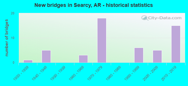
- New bridges - historical statistics
- 11930-1939
- 51940-1949
- 31960-1969
- 181970-1979
- 61990-1999
- 52000-2009
- 152010-2019
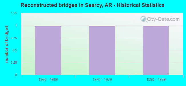
- Reconstructed bridges - Historical Statistics
- 11960-1969
- 11970-1979
- 11980-1989
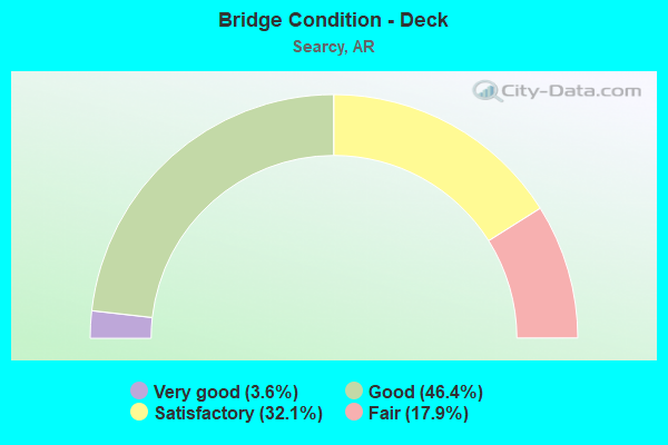
- Bridge Condition - Deck
- 3.6%Very good
- 46.4%Good
- 32.1%Satisfactory
- 17.9%Fair
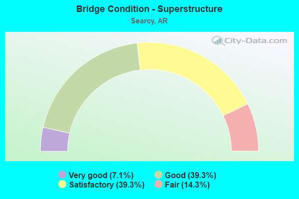
- Bridge Condition - Superstructure
- 7.1%Very good
- 39.3%Good
- 39.3%Satisfactory
- 14.3%Fair
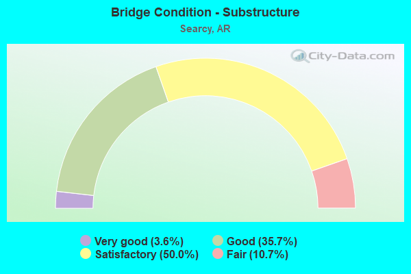
- Bridge Condition - Substructure
- 3.6%Very good
- 35.7%Good
- 50.0%Satisfactory
- 10.7%Fair
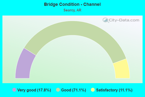
- Bridge Condition - Channel
- 17.8%Very good
- 71.1%Good
- 11.1%Satisfactory
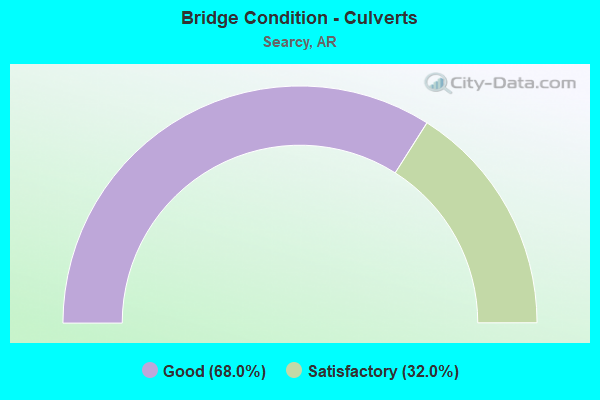
- Bridge Condition - Culverts
- 68.0%Good
- 32.0%Satisfactory
Find on map >> Show street view
Structure Number: X1091, Location: SE EDGE OF SUNNY HILL (Lat: 35.288128, Lng: -91.767739), Route carried "on" structure: State highway 16, Year Built: 2001, Status: Open, Structure Length: 1.25m (4.10ft), Average Daily Traffic: 5,600 (year 2018), Truck Traffic: 1%, Average Future Daily Traffic: 8,537 (year 2028), Design Load: H 20, Features Intersected: CREEK
Minimum Vertical Clearance: 30+ m (98+ ft), Kilometerpoint: 18.604, Lanes on structure: 2, Base Highway Network: Yes, Owner: State Highway Agency, Approaching Roadway Width: 12.2m (40.0ft), Material/Design: Concrete, Design/Construction: Culvert, Number Of Spans In Main Unit: 4, Length of Maximum Span: 3.0m (9.8ft)
Condition: Channel: Good, Culverts: Good, Operating Rating: 39.9 metric tons, Method Used To Determine Operating Rating: Load Factor (LF), Inventory Rating: 23.6 metric tons, Method Used To Determine Inventory Rating: Load Factor (LF), Structural Evaluation: Somewhat better than minimum adequacy, Waterway Adequacy: Equal to present desirable criteria, Approach Roadway Alignment: Better than present minimum criteria, Designated Inspection Frequency: Every 24 months, Critical Feature Inspection Frequency: Every 24 months, Inspection Date: March 2021
Find on map >> Show street view
Structure Number: X1112, Location: .98 M N JCT US 67 B (Lat: 35.257500, Lng: -91.744978), Route carried "on" structure: State highway 16, Year Built: 2003, Status: Open, Structure Length: 1.55m (5.09ft), Average Daily Traffic: 8,500 (year 2018), Truck Traffic: 1%, Average Future Daily Traffic: 14,907 (year 2028), Design Load: H 20, Features Intersected: Deener Creek
Minimum Vertical Clearance: 30+ m (98+ ft), Kilometerpoint: 22.965, Lanes on structure: 4, Owner: State Highway Agency, Approaching Roadway Width: 15.8m (51.8ft), Material/Design: Concrete, Design/Construction: Culvert, Number Of Spans In Main Unit: 4, Length of Maximum Span: 3.7m (12.1ft)
Condition: Channel: Good, Culverts: Good, Operating Rating: 38.1 metric tons, Method Used To Determine Operating Rating: Load Factor (LF), Inventory Rating: 22.7 metric tons, Method Used To Determine Inventory Rating: Load Factor (LF), Structural Evaluation: Somewhat better than minimum adequacy, Waterway Adequacy: Equal to present desirable criteria, Approach Roadway Alignment: Equal to present desirable criteria, Designated Inspection Frequency: Every 24 months, Critical Feature Inspection Frequency: Every 24 months, Inspection Date: March 2021
Find on map >> Show street view
Structure Number: X1113, Location: 1.62 M W US 67B (Lat: 35.266619, Lng: -91.747378), Route carried "on" structure: State highway 16, Year Built: 2003, Status: Open, Structure Length: 0.64m (2.10ft), Average Daily Traffic: 8,500 (year 2018), Truck Traffic: 1%, Average Future Daily Traffic: 12,196 (year 2028), Design Load: H 20, Features Intersected: Rocky Branch
Minimum Vertical Clearance: 30+ m (98+ ft), Kilometerpoint: 21.887, Lanes on structure: 4, Owner: State Highway Agency, Approaching Roadway Width: 15.8m (51.8ft), Skew: 1 degrees, Material/Design: Concrete, Design/Construction: Culvert, Number Of Spans In Main Unit: 2, Length of Maximum Span: 3.0m (9.8ft)
Condition: Channel: Good, Culverts: Satisfactory, Operating Rating: 39.9 metric tons, Method Used To Determine Operating Rating: Load Factor (LF), Inventory Rating: 23.6 metric tons, Method Used To Determine Inventory Rating: Load Factor (LF), Structural Evaluation: Somewhat better than minimum adequacy, Waterway Adequacy: Equal to present desirable criteria, Approach Roadway Alignment: Equal to present desirable criteria, Designated Inspection Frequency: Every 24 months, Critical Feature Inspection Frequency: Every 24 months, Inspection Date: March 2021
Find on map >> Show street view
Structure Number: X1483, Location: 2.43 Mi N of Jct SH 267 (Lat: 35.210169, Lng: -91.793158), Route carried "on" structure: County highway , Year Built: 2014, Status: Open, Structure Length: 0.75m (2.46ft), Average Daily Traffic: 91 (year 2015), Truck Traffic: 1%, Average Future Daily Traffic: 30 (year 2035), Design Load: HL 93, Features Intersected: Ditch, Facility Carried by Structure: HoneyHillLoopWHITE
Minimum Vertical Clearance: 30+ m (98+ ft), Kilometerpoint: 12.006, Lanes on structure: 2, Owner: State Highway Agency, Approaching Roadway Width: 6.8m (22.3ft), Material/Design: Concrete, Design/Construction: Culvert, Number Of Spans In Main Unit: 2, Length of Maximum Span: 3.7m (12.1ft)
Condition: Channel: Very good, Culverts: Good, Operating Rating: 44.5 metric tons, Method Used To Determine Operating Rating: Load and Resistance Factor (LRFR), Inventory Rating: 32.7 metric tons, Method Used To Determine Inventory Rating: Load and Resistance Factor (LRFR), Structural Evaluation: Better than present minimum criteria, Waterway Adequacy: Equal to present desirable criteria, Approach Roadway Alignment: Equal to present desirable criteria, Designated Inspection Frequency: Every 24 months, Critical Feature Inspection Frequency: Every 24 months, Inspection Date: May 2020, Deck Structure Type: Concrete Cast-file-Place, Wearing Surface/Protective System: Wearing Surface: Bituminous
Find on map >> Show street view
Structure Number: X1484, Location: Jct.N.Main&N.ByPass(Ramp) (Lat: 35.266811, Lng: -91.734147), Route carried "on" structure: Ramp State highway 13, Year Built: 2016, Status: Open, Structure Length: 2.62m (8.60ft), Average Daily Traffic: 12 (year 2017), Truck Traffic: 1%, Average Future Daily Traffic: 250 (year 2035), Design Load: HL 93, Features Intersected: Rocky Branch
Minimum Vertical Clearance: 30+ m (98+ ft), Kilometerpoint: 23.416, Lanes on structure: 2, Owner: State Highway Agency, Approaching Roadway Width: 9.6m (31.5ft), Material/Design: Concrete, Design/Construction: Culvert, Number Of Spans In Main Unit: 9, Length of Maximum Span: 2.4m (7.9ft)
Condition: Channel: Very good, Culverts: Good, Operating Rating: 45.4 metric tons, Method Used To Determine Operating Rating: Load and Resistance Factor (LRFR), Inventory Rating: 32.7 metric tons, Method Used To Determine Inventory Rating: Load and Resistance Factor (LRFR), Structural Evaluation: Better than present minimum criteria, Waterway Adequacy: Equal to present desirable criteria, Approach Roadway Alignment: Equal to present desirable criteria, Designated Inspection Frequency: Every 24 months, Critical Feature Inspection Frequency: Every 24 months, Inspection Date: January 2021, Deck Structure Type: Concrete Precast Panels, Wearing Surface/Protective System: Wearing Surface: Bituminous
Find on map >> Show street view
Structure Number: X1523, Location: 3.24 mi W SH 16 (Lat: 35.256108, Lng: -91.793989), Route carried "on" structure: State highway 13, Year Built: 2018, Status: Open, Structure Length: 0.79m (2.59ft), Average Daily Traffic: 12 (year 2017), Truck Traffic: 7%, Average Future Daily Traffic: 6,500 (year 2036), Design Load: HL 93, Features Intersected: Deener Creek
Minimum Vertical Clearance: 30+ m (98+ ft), Kilometerpoint: 16.576, Lanes on structure: 2, Owner: State Highway Agency, Approaching Roadway Width: 12.5m (41.0ft), Skew: 3 degrees, Material/Design: Concrete, Design/Construction: Culvert, Number Of Spans In Main Unit: 2, Length of Maximum Span: 3.9m (12.8ft)
Condition: Channel: Good, Culverts: Good, Operating Rating: 46.3 metric tons, Method Used To Determine Operating Rating: Load and Resistance Factor (LRFR), Inventory Rating: 32.7 metric tons, Method Used To Determine Inventory Rating: Load and Resistance Factor (LRFR), Structural Evaluation: Better than present minimum criteria, Waterway Adequacy: Equal to present desirable criteria, Approach Roadway Alignment: Equal to present desirable criteria, Designated Inspection Frequency: Every 24 months, Critical Feature Inspection Frequency: Every 24 months, Inspection Date: July 2020, Deck Structure Type: Concrete Cast-file-Place, Wearing Surface/Protective System: Wearing Surface: Bituminous
Find on map >> Show street view
Structure Number: X1524, Location: .95 mi W SH 16 (Lat: 35.269169, Lng: -91.765828), Route carried "on" structure: State highway 13, Year Built: 2018, Status: Open, Structure Length: 0.87m (2.85ft), Average Daily Traffic: 12 (year 2017), Truck Traffic: 7%, Average Future Daily Traffic: 6,500 (year 2036), Design Load: HL 93, Features Intersected: Rocky Branch
Minimum Vertical Clearance: 30+ m (98+ ft), Kilometerpoint: 20.262, Lanes on structure: 2, Owner: State Highway Agency, Approaching Roadway Width: 12.5m (41.0ft), Material/Design: Concrete, Design/Construction: Culvert, Number Of Spans In Main Unit: 3, Length of Maximum Span: 2.7m (8.9ft)
Condition: Channel: Good, Culverts: Satisfactory, Operating Rating: 45.4 metric tons, Method Used To Determine Operating Rating: Load and Resistance Factor (LRFR), Inventory Rating: 32.7 metric tons, Method Used To Determine Inventory Rating: Load and Resistance Factor (LRFR), Structural Evaluation: Equal to present minimum criteria, Waterway Adequacy: Equal to present desirable criteria, Approach Roadway Alignment: Equal to present desirable criteria, Designated Inspection Frequency: Every 24 months, Critical Feature Inspection Frequency: Every 24 months, Inspection Date: July 2020, Deck Structure Type: Concrete Cast-file-Place, Wearing Surface/Protective System: Wearing Surface: Bituminous
Find on map >> Show street view
Structure Number: X1525, Location: .05 mi W SH 16 (Lat: 35.269169, Lng: -91.751669), Route carried "on" structure: State highway 13, Year Built: 2018, Status: Open, Structure Length: 0.72m (2.36ft), Average Daily Traffic: 12 (year 2017), Truck Traffic: 7%, Average Future Daily Traffic: 6,500 (year 2036), Design Load: HL 93, Features Intersected: Creek
Minimum Vertical Clearance: 30+ m (98+ ft), Kilometerpoint: 21.630, Lanes on structure: 2, Owner: State Highway Agency, Approaching Roadway Width: 13.9m (45.6ft), Skew: 4 degrees, Material/Design: Concrete, Design/Construction: Culvert, Number Of Spans In Main Unit: 2, Length of Maximum Span: 3.4m (11.2ft)
Condition: Channel: Good, Culverts: Good, Operating Rating: 39.9 metric tons, Method Used To Determine Operating Rating: Load and Resistance Factor (LRFR), Inventory Rating: 30.8 metric tons, Method Used To Determine Inventory Rating: Load and Resistance Factor (LRFR), Structural Evaluation: Better than present minimum criteria, Waterway Adequacy: Equal to present desirable criteria, Approach Roadway Alignment: Equal to present desirable criteria, Designated Inspection Frequency: Every 24 months, Critical Feature Inspection Frequency: Every 24 months, Inspection Date: July 2020, Deck Structure Type: Concrete Cast-file-Place, Wearing Surface/Protective System: Wearing Surface: Bituminous
Find on map >> Show street view
Structure Number: X1526, Location: .10 East SH 16 (Lat: 35.269169, Lng: -91.746939), Route carried "on" structure: State highway 13, Year Built: 2018, Status: Open, Structure Length: 1.19m (3.90ft), Average Daily Traffic: 12 (year 2017), Truck Traffic: 8%, Average Future Daily Traffic: 5,800 (year 2035), Design Load: HL 93, Features Intersected: Ditch
Minimum Vertical Clearance: 30+ m (98+ ft), Kilometerpoint: 22.064, Lanes on structure: 2, Owner: State Highway Agency, Approaching Roadway Width: 12.3m (40.4ft), Skew: 4 degrees, Material/Design: Concrete, Design/Construction: Culvert, Number Of Spans In Main Unit: 3, Length of Maximum Span: 3.4m (11.2ft)
Condition: Channel: Good, Culverts: Good, Operating Rating: 43.5 metric tons, Method Used To Determine Operating Rating: Load and Resistance Factor (LRFR), Inventory Rating: 32.7 metric tons, Method Used To Determine Inventory Rating: Load and Resistance Factor (LRFR), Structural Evaluation: Better than present minimum criteria, Waterway Adequacy: Equal to present desirable criteria, Approach Roadway Alignment: Equal to present desirable criteria, Designated Inspection Frequency: Every 24 months, Critical Feature Inspection Frequency: Every 24 months, Inspection Date: July 2020, Deck Structure Type: Concrete Precast Panels, Wearing Surface/Protective System: Wearing Surface: Bituminous
Find on map >> Show street view
Structure Number: X1527, Location: .43 West of Main Street (Lat: 35.268058, Lng: -91.737778), Route carried "on" structure: State highway 13, Year Built: 2018, Status: Open, Structure Length: 0.98m (3.22ft), Average Daily Traffic: 12 (year 2017), Truck Traffic: 8%, Average Future Daily Traffic: 5,800 (year 2035), Design Load: HL 93, Features Intersected: Creek
Minimum Vertical Clearance: 30+ m (98+ ft), Kilometerpoint: 22.547, Lanes on structure: 2, Owner: State Highway Agency, Approaching Roadway Width: 12.4m (40.7ft), Skew: 1 degrees, Material/Design: Concrete, Design/Construction: Culvert, Number Of Spans In Main Unit: 3, Length of Maximum Span: 3.0m (9.8ft)
Condition: Channel: Good, Culverts: Good, Operating Rating: 54.4 metric tons, Method Used To Determine Operating Rating: Load and Resistance Factor (LRFR), Inventory Rating: 32.7 metric tons, Method Used To Determine Inventory Rating: Load and Resistance Factor (LRFR), Structural Evaluation: Better than present minimum criteria, Waterway Adequacy: Equal to present desirable criteria, Approach Roadway Alignment: Equal to present desirable criteria, Designated Inspection Frequency: Every 24 months, Critical Feature Inspection Frequency: Every 24 months, Inspection Date: July 2020, Deck Structure Type: Concrete Cast-file-Place, Wearing Surface/Protective System: Wearing Surface: Bituminous
Find on map >> Show street view
Structure Number: X1528, Location: 0.15 mi W of Main Street (Lat: 35.267778, Lng: -91.737778), Route carried "on" structure: State highway 13, Year Built: 2018, Status: Open, Structure Length: 2.29m (7.51ft), Average Daily Traffic: 12 (year 2017), Truck Traffic: 8%, Average Future Daily Traffic: 5,800 (year 2035), Design Load: HL 93, Features Intersected: Rocky Branch
Minimum Vertical Clearance: 30+ m (98+ ft), Kilometerpoint: 22.965, Lanes on structure: 2, Owner: State Highway Agency, Approaching Roadway Width: 12.3m (40.4ft), Skew: 4 degrees, Material/Design: Concrete, Design/Construction: Culvert, Number Of Spans In Main Unit: 5, Length of Maximum Span: 4.4m (14.4ft)
Condition: Channel: Good, Culverts: Good, Operating Rating: 54.4 metric tons, Method Used To Determine Operating Rating: Load and Resistance Factor (LRFR), Inventory Rating: 32.7 metric tons, Method Used To Determine Inventory Rating: Load and Resistance Factor (LRFR), Structural Evaluation: Better than present minimum criteria, Waterway Adequacy: Equal to present desirable criteria, Approach Roadway Alignment: Equal to present desirable criteria, Designated Inspection Frequency: Every 24 months, Critical Feature Inspection Frequency: Every 24 months, Inspection Date: July 2020, Deck Structure Type: Concrete Cast-file-Place, Wearing Surface/Protective System: Wearing Surface: Bituminous
Find on map >> Show street view
Structure Number: 5357, Location: .15 MI N SH 367 (Lat: 35.203319, Lng: -91.732581), Route carried "under" structure: US 67, Structure Length: 0. m, Average Daily Traffic: 12,000 (year 2014), Truck Traffic: 1%, Features Intersected: US 67-SEC 12
Minimum Vertical Clearance: 5.02m (16.47ft), Kilometerpoint: 26.586, Length of Maximum Span: 0.0m
Find on map >> Show street view
Structure Number: 5357, Location: .15 MI N SH 367 (Lat: 35.203319, Lng: -91.732581), Route carried "under" structure: US 67, Structure Length: 0. m, Average Daily Traffic: 12,000 (year 2014), Truck Traffic: 1%, Features Intersected: US 67-SEC 12
Minimum Vertical Clearance: 5.05m (16.57ft), Kilometerpoint: 26.586, Length of Maximum Span: 0.0m
Find on map >> Show street view
Structure Number: 5449, Location: JCT US 67 & SH 367 (Lat: 35.221000, Lng: -91.717369), Route carried "under" structure: US 67, Structure Length: 0. m, Average Daily Traffic: 12,000 (year 2014), Truck Traffic: 1%, Features Intersected: US 67-SEC 12
Minimum Vertical Clearance: 4.96m (16.27ft), Kilometerpoint: 29.016, Length of Maximum Span: 0.0m
Find on map >> Show street view
Structure Number: 5449, Location: JCT US 67 & SH 367 (Lat: 35.221000, Lng: -91.717369), Route carried "under" structure: US 67, Structure Length: 0. m, Average Daily Traffic: 12,000 (year 2014), Truck Traffic: 1%, Features Intersected: US 67-SEC 12
Minimum Vertical Clearance: 5.05m (16.57ft), Kilometerpoint: 29.016, Length of Maximum Span: 0.0m
Find on map >> Show street view
Structure Number: 6602, Location: 2.1 MI E OF SH 36&MAIN (Lat: 35.236050, Lng: -91.701881), Route carried "under" structure: US 67, Structure Length: 0. m, Average Daily Traffic: 12,000 (year 2014), Truck Traffic: 1%, Features Intersected: US HWY 67&167, Facility Carried by Structure: SH 36 O/P White Co
Minimum Vertical Clearance: 5.24m (17.19ft), Kilometerpoint: 31.189, Length of Maximum Span: 0.0m
Find on map >> Show street view
Structure Number: 6602, Location: 2.1 MI E OF SH 36&MAIN (Lat: 35.236050, Lng: -91.701881), Route carried "under" structure: US 67, Structure Length: 0. m, Average Daily Traffic: 12,000 (year 2014), Truck Traffic: 1%, Features Intersected: US HWY 67&167, Facility Carried by Structure: SH 36 O/P White Co
Minimum Vertical Clearance: 5.21m (17.09ft), Kilometerpoint: 31.189, Length of Maximum Span: 0.0m
Find on map >> Show street view
Structure Number: 7353, Location: 0.85 MI E of SH 16 (Lat: 35.267711, Lng: -91.734750), Route carried "under" structure: Bypass State highway 43, Structure Length: 0. m, Average Daily Traffic: 3,800 (year 2015), Truck Traffic: 1%, Features Intersected: North Main Street Searcy, Facility Carried by Structure: SH 13
Minimum Vertical Clearance: 6.55m (21.49ft), Kilometerpoint: 1.931, Length of Maximum Span: 0.0m
Find on map >> Show street view
Structure Number: A545, Location: 1.9 M NO JCT US 67 &SH367 (Lat: 35.241469, Lng: -91.695369), Route carried "under" structure: City street 43930, Structure Length: 0. m, Average Daily Traffic: 1,714 (year 1983), Truck Traffic: 1%, Features Intersected: EAST PARK STREET, Facility Carried by Structure: US 67 WHITE COUNTY
Minimum Vertical Clearance: 7.10m (23.29ft), Kilometerpoint: 3.911, Length of Maximum Span: 0.0m
Find on map >> Show street view
Structure Number: A5535, Location: JCT US67C & HWY36 RACE ST (Lat: 35.250150, Lng: -91.689369), Route carried "under" structure: Alternate US 67, Structure Length: 0. m, Average Daily Traffic: 21,000 (year 2014), Truck Traffic: 1%, Features Intersected: US 67-SEC 12C
Minimum Vertical Clearance: 4.96m (16.27ft), Kilometerpoint: 9.944, Length of Maximum Span: 0.0m
Find on map >> Show street view
Structure Number: B545, Location: 1.9 MI N JCT US 67 & 367 (Lat: 35.241419, Lng: -91.695050), Route carried "under" structure: City street 43930, Structure Length: 0. m, Average Daily Traffic: 1,205 (year 1983), Truck Traffic: 1%, Features Intersected: EAST PARK STREET, Facility Carried by Structure: US 67 WHITE COUNTY
Minimum Vertical Clearance: 7.19m (23.59ft), Kilometerpoint: 3.911, Length of Maximum Span: 0.0m
Find on map >> Show street view
Structure Number: B5535, Location: JCT US 67 & HWY36 RACE ST (Lat: 35.250150, Lng: -91.689081), Route carried "under" structure: Alternate US 67, Structure Length: 0. m, Average Daily Traffic: 21,000 (year 2014), Truck Traffic: 1%, Features Intersected: US 67-SEC 12C
Minimum Vertical Clearance: 5.39m (17.68ft), Kilometerpoint: 9.944, Length of Maximum Span: 0.0m