Bridge Statistics for Seymour, Indiana (IN)
Condition, Traffic, Stress, Structural Evaluation, Project Costs
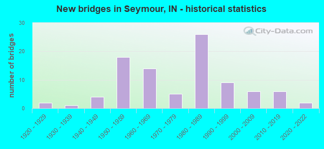
- New bridges - historical statistics
- 21920-1929
- 11930-1939
- 41940-1949
- 181950-1959
- 141960-1969
- 51970-1979
- 261980-1989
- 91990-1999
- 62000-2009
- 62010-2019
- 22020-2022
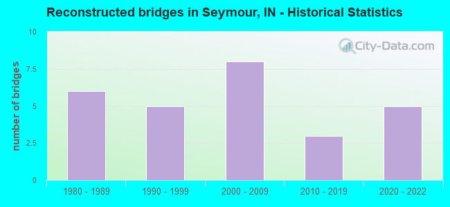
- Reconstructed bridges - Historical Statistics
- 61980-1989
- 51990-1999
- 82000-2009
- 32010-2019
- 52020-2022
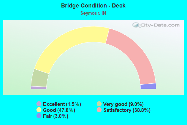
- Bridge Condition - Deck
- 1.5%Excellent
- 9.0%Very good
- 47.8%Good
- 38.8%Satisfactory
- 3.0%Fair
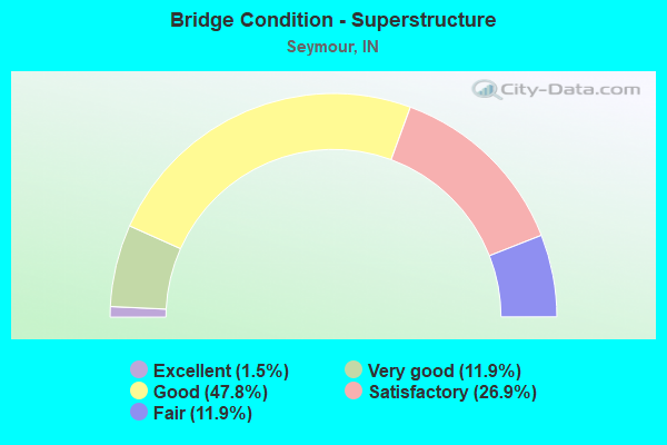
- Bridge Condition - Superstructure
- 1.5%Excellent
- 11.9%Very good
- 47.8%Good
- 26.9%Satisfactory
- 11.9%Fair
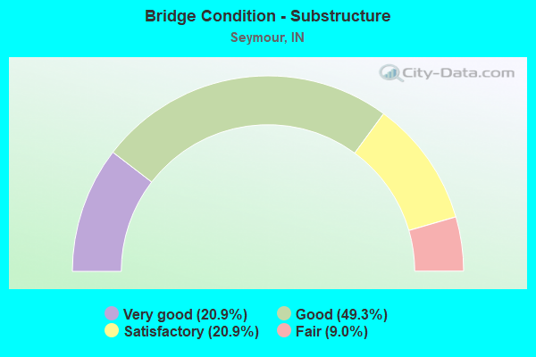
- Bridge Condition - Substructure
- 20.9%Very good
- 49.3%Good
- 20.9%Satisfactory
- 9.0%Fair
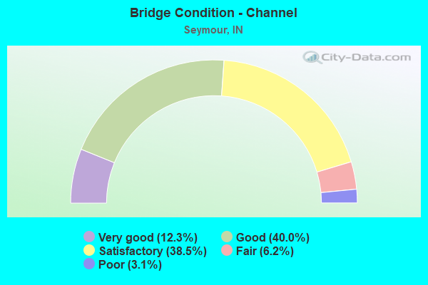
- Bridge Condition - Channel
- 12.3%Very good
- 40.0%Good
- 38.5%Satisfactory
- 6.2%Fair
- 3.1%Poor
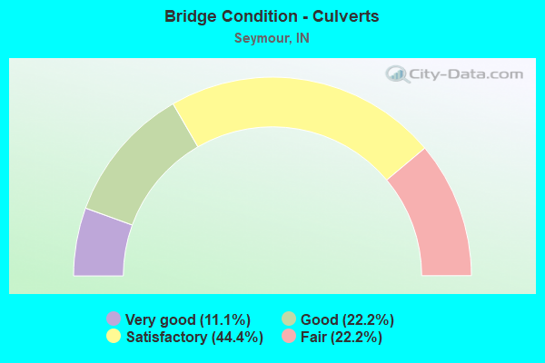
- Bridge Condition - Culverts
- 11.1%Very good
- 22.2%Good
- 44.4%Satisfactory
- 22.2%Fair
Find on map >> Show street view
Structure Number: 3522, Location: 04.18 N US 31 (Lat: 38.958189, Lng: -85.843642), Route carried "under" structure: US 50, Year Built: 1958, Structure Length: 0. m, Average Daily Traffic: 14,303 (year 2004), Truck Traffic: 5%, Features Intersected: US 50 EB, Facility Carried by Structure: I-65 SB
Minimum Vertical Clearance: 4.55m (14.93ft), Kilometerpoint: 41.907, Lanes on structure: 3, Lanes under structure: 6, Material/Design: Steel continuous, Design/Construction: Stringer/Multi-beam, Length of Maximum Span: 19.7m (64.6ft)
Find on map >> Show street view
Structure Number: 3525, Location: 01.76 N US 50 (Lat: 38.983811, Lng: -85.843536), Route carried "under" structure: Interstate 65, Year Built: 1960, Structure Length: 0. m, Average Daily Traffic: 16,108 (year 2004), Truck Traffic: 10%, Features Intersected: I-65 NB, Facility Carried by Structure: ENOS ROAD
Minimum Vertical Clearance: 5.21m (17.09ft), Kilometerpoint: 82.575, Lanes on structure: 2, Lanes under structure: 6, Material/Design: Concrete continuous, Design/Construction: Stringer/Multi-beam, Length of Maximum Span: 19.9m (65.3ft)
Find on map >> Show street view
Structure Number: 3525, Location: 01.76 N US 50 (Lat: 38.983811, Lng: -85.843536), Route carried "under" structure: Interstate 65, Year Built: 1960, Structure Length: 0. m, Average Daily Traffic: 16,108 (year 2004), Truck Traffic: 10%, Features Intersected: I-65 SB, Facility Carried by Structure: ENOS ROAD
Minimum Vertical Clearance: 5.18m (16.99ft), Kilometerpoint: 82.575, Lanes on structure: 2, Lanes under structure: 6, Material/Design: Concrete continuous, Design/Construction: Stringer/Multi-beam, Length of Maximum Span: 19.9m (65.3ft)
Find on map >> Show street view
Structure Number: 3528, Location: 02.79 S SR 11 (Lat: 38.998300, Lng: -85.853303), Route carried "under" structure: Interstate 65, Year Built: 1962, Structure Length: 0. m, Average Daily Traffic: 16,108 (year 2004), Truck Traffic: 10%, Features Intersected: I-65 SB, Facility Carried by Structure: CR 800 N
Minimum Vertical Clearance: 4.88m (16.01ft), Kilometerpoint: 84.539, Lanes on structure: 2, Lanes under structure: 4, Material/Design: Steel continuous, Design/Construction: Stringer/Multi-beam, Length of Maximum Span: 20.7m (67.9ft)
Find on map >> Show street view
Structure Number: 3528, Location: 02.79 S SR 11 (Lat: 38.998300, Lng: -85.853303), Route carried "under" structure: Interstate 65, Year Built: 1962, Structure Length: 0. m, Average Daily Traffic: 16,108 (year 2004), Truck Traffic: 10%, Features Intersected: I-65 NB, Facility Carried by Structure: CR 800 N
Minimum Vertical Clearance: 4.90m (16.08ft), Kilometerpoint: 84.539, Lanes on structure: 2, Lanes under structure: 4, Material/Design: Steel continuous, Design/Construction: Stringer/Multi-beam, Length of Maximum Span: 20.7m (67.9ft)
Find on map >> Show street view
Structure Number: 3529, Location: 02.20 S SR 11 (Lat: 39.003831, Lng: -85.862075), Route carried "under" structure: Interstate 65, Year Built: 1960, Structure Length: 0. m, Average Daily Traffic: 16,108 (year 2004), Truck Traffic: 10%, Features Intersected: I-65 NB, Facility Carried by Structure: REDDING ROAD
Minimum Vertical Clearance: 5.16m (16.93ft), Kilometerpoint: 85.488, Lanes on structure: 2, Lanes under structure: 4, Material/Design: Concrete continuous, Design/Construction: Stringer/Multi-beam, Length of Maximum Span: 20.1m (65.9ft)
Find on map >> Show street view
Structure Number: 3529, Location: 02.20 S SR 11 (Lat: 39.003831, Lng: -85.862075), Route carried "under" structure: Interstate 65, Year Built: 1960, Structure Length: 0. m, Average Daily Traffic: 16,108 (year 2004), Truck Traffic: 10%, Features Intersected: I-65 SB, Facility Carried by Structure: REDDING ROAD
Minimum Vertical Clearance: 5.18m (16.99ft), Kilometerpoint: 85.488, Lanes on structure: 2, Lanes under structure: 4, Material/Design: Concrete continuous, Design/Construction: Stringer/Multi-beam, Length of Maximum Span: 20.1m (65.9ft)
Find on map >> Show street view
Structure Number: 79024, Location: 08.54 N SR 46 (Lat: 38.983811, Lng: -85.843531), Route carried "under" structure: Interstate 69, Year Built: 2018, Structure Length: 0. m, Average Daily Traffic: 22,827 (year 2016), Truck Traffic: 22%, Features Intersected: I-69 SB, Facility Carried by Structure: CHAMBERS PIKE
Minimum Vertical Clearance: 5.39m (17.68ft), Kilometerpoint: 206.962, Lanes on structure: 2, Lanes under structure: 6, Material/Design: Prestressed concrete continuous, Design/Construction: Stringer/Multi-beam, Length of Maximum Span: 29.9m (98.1ft)
Find on map >> Show street view
Structure Number: 79024, Location: 08.54 N SR 46 (Lat: 38.983811, Lng: -85.843531), Route carried "under" structure: Interstate 69, Year Built: 2018, Structure Length: 0. m, Average Daily Traffic: 24,621 (year 2016), Truck Traffic: 20%, Features Intersected: I-69 NB, Facility Carried by Structure: CHAMBERS PIKE
Minimum Vertical Clearance: 5.30m (17.39ft), Kilometerpoint: 206.962, Lanes on structure: 2, Lanes under structure: 6, Material/Design: Prestressed concrete continuous, Design/Construction: Stringer/Multi-beam, Length of Maximum Span: 29.9m (98.1ft)
Find on map >> Show street view
Structure Number: 79024, Location: 08.54 N SR 46 (Lat: 38.983811, Lng: -85.843531), Route carried "under" structure: County highway , Year Built: 2018, Structure Length: 0. m, Average Daily Traffic: 168 (year 2016), Truck Traffic: 2%, Features Intersected: BURMA ROAD, Facility Carried by Structure: CHAMBERS PIKE
Minimum Vertical Clearance: 4.80m (15.75ft), Kilometerpoint: 0.000, Lanes on structure: 2, Lanes under structure: 6, Material/Design: Prestressed concrete continuous, Design/Construction: Stringer/Multi-beam, Length of Maximum Span: 29.9m (98.1ft)