Bridge Statistics for Shawnee, Kansas (KS)
Condition, Traffic, Stress, Structural Evaluation, Project Costs
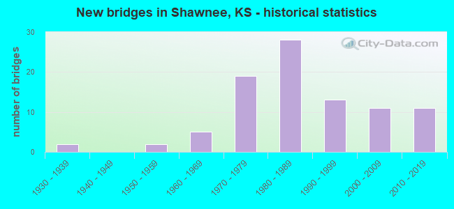
- New bridges - historical statistics
- 21930-1939
- 21950-1959
- 51960-1969
- 191970-1979
- 281980-1989
- 131990-1999
- 112000-2009
- 112010-2019
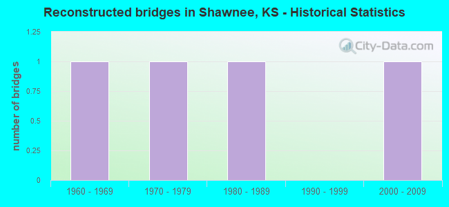
- Reconstructed bridges - Historical Statistics
- 11960-1969
- 11970-1979
- 11980-1989
- 01990-1999
- 12000-2009
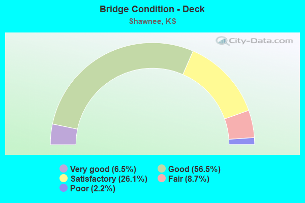
- Bridge Condition - Deck
- 6.5%Very good
- 56.5%Good
- 26.1%Satisfactory
- 8.7%Fair
- 2.2%Poor
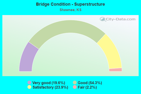
- Bridge Condition - Superstructure
- 19.6%Very good
- 54.3%Good
- 23.9%Satisfactory
- 2.2%Fair
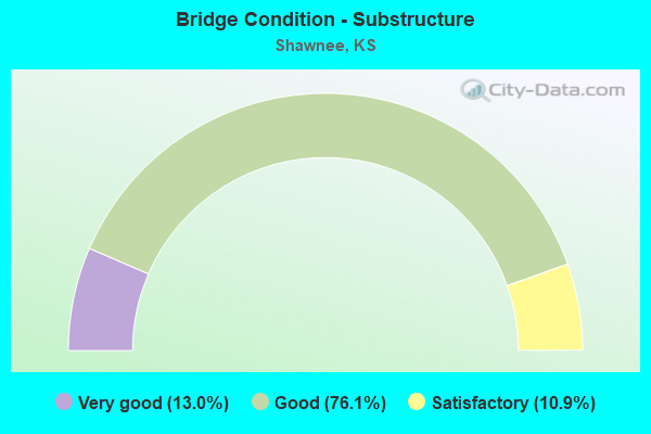
- Bridge Condition - Substructure
- 13.0%Very good
- 76.1%Good
- 10.9%Satisfactory
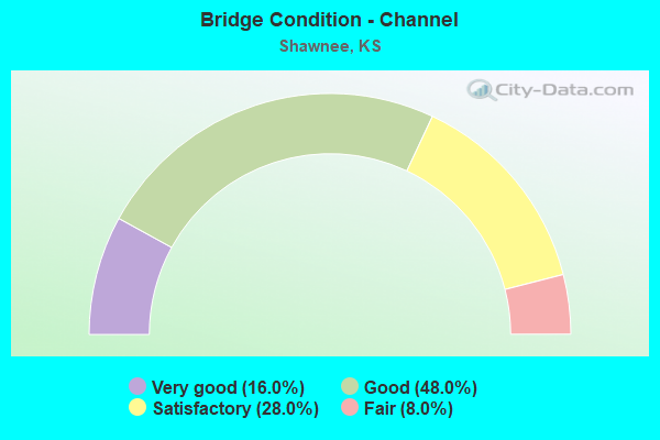
- Bridge Condition - Channel
- 16.0%Very good
- 48.0%Good
- 28.0%Satisfactory
- 8.0%Fair
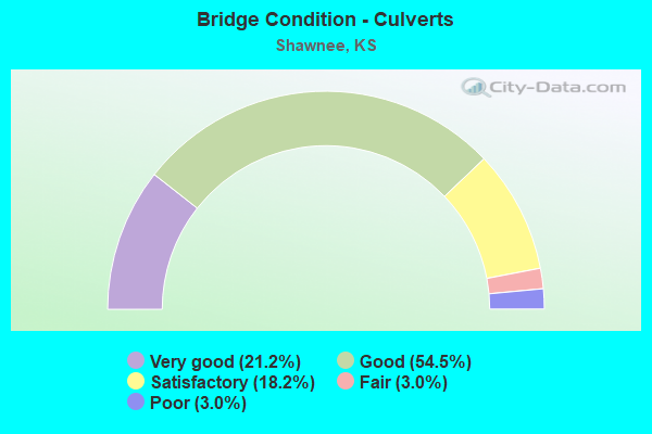
- Bridge Condition - Culverts
- 21.2%Very good
- 54.5%Good
- 18.2%Satisfactory
- 3.0%Fair
- 3.0%Poor
Find on map >> Show street view
Structure Number: 6014, Location: 0.7S OF MAPLETON (Lat: 38.999783, Lng: -94.880278), Route carried "on" structure: County highway 51, Year Built: 1970, Status: Posted for load, Structure Length: 8.90m (29.20ft), Average Daily Traffic: 133 (year 2006), Truck Traffic: 11%, Average Future Daily Traffic: 133 (year 2039), Design Load: H 15, Features Intersected: LITTLE OSAGE RIVER
Minimum Vertical Clearance: 30.47m (99.97ft), Kilometerpoint: 27.479, Lanes on structure: 2, Owner: County Highway Agency, Approaching Roadway Width: 9.1m (29.9ft), Material/Design: Steel continuous, Design/Construction: Stringer/Multi-beam, Number Of Spans In Main Unit: 4, Length of Maximum Span: 24.4m (80.1ft), Curb or Sidewalk Widths: Left: 0.4m (1.3ft), Right: 0.4m (1.3ft), Curb-To-Curb Width: 8.5m (27.9ft), Out-to-Out Width: 9.4m (30.8ft)
Condition: Deck: Satisfactory, Superstructure: Very good, Substructure: Good, Channel: Satisfactory, Operating Rating: 41.6 metric tons, Method Used To Determine Operating Rating: Load Factor (LF), Inventory Rating: 24.9 metric tons, Method Used To Determine Inventory Rating: Load Factor (LF), Structural Evaluation: Equal to present minimum criteria, Deck Geometry: Equal to present minimum criteria, Waterway Adequacy: Equal to present desirable criteria, Approach Roadway Alignment: Equal to present minimum criteria, Designated Inspection Frequency: Every 24 months, Inspection Date: March 2020, Deck Structure Type: Concrete Cast-file-Place
Find on map >> Show street view
Structure Number: 52019, Location: 6.4E 1.0N OF LINWOOD (Lat: 39.014528, Lng: -94.908919), Route carried "on" structure: County highway 387, Year Built: 1975, Status: Open, Structure Length: 0.96m (3.15ft), Average Daily Traffic: 875 (year 2013), Truck Traffic: 11%, Average Future Daily Traffic: 914 (year 2038), Design Load: H 20, Features Intersected: UNNAMED STREAM, Facility Carried by Structure: SH-60 LORING DR
Minimum Vertical Clearance: 30.47m (99.97ft), Kilometerpoint: 0.000, Lanes on structure: 2, Owner: County Highway Agency, Approaching Roadway Width: 7.4m (24.3ft), Skew: 3 degrees, Material/Design: Concrete, Design/Construction: Culvert, Number Of Spans In Main Unit: 3, Length of Maximum Span: 3.0m (9.8ft)
Condition: Channel: Fair, Culverts: Good, Operating Rating: 32.4 metric tons, Method Used To Determine Operating Rating: Load Factor (LF), Inventory Rating: 18.0 metric tons, Method Used To Determine Inventory Rating: Load Factor (LF), Structural Evaluation: Somewhat better than minimum adequacy, Waterway Adequacy: Equal to present minimum criteria, Approach Roadway Alignment: Equal to present desirable criteria, Designated Inspection Frequency: Every 24 months, Inspection Date: March 2020
Find on map >> Show street view
Structure Number: 71018, Location: 3.0E OF OSBORNE (Lat: 39.438169, Lng: -98.638228), Route carried "on" structure: County highway 517, Year Built: 1958, Status: Open, Structure Length: 0.64m (2.10ft), Average Daily Traffic: 435 (year 2014), Truck Traffic: 20%, Average Future Daily Traffic: 550 (year 2041), Design Load: H 20, Features Intersected: TRIB SOUTH FORK SOLOMON
Minimum Vertical Clearance: 30.47m (99.97ft), Kilometerpoint: 4.876, Lanes on structure: 2, Owner: County Highway Agency, Approaching Roadway Width: 7.8m (25.6ft), Material/Design: Concrete, Design/Construction: Culvert, Number Of Spans In Main Unit: 2, Length of Maximum Span: 3.0m (9.8ft), Curb-To-Curb Width: 8.5m (27.9ft), Out-to-Out Width: 9.0m (29.5ft)
Condition: Channel: Satisfactory, Culverts: Satisfactory, Operating Rating: 38.6 metric tons, Method Used To Determine Operating Rating: Allowable Stress (AS), Inventory Rating: 23.1 metric tons, Method Used To Determine Inventory Rating: Allowable Stress (AS), Structural Evaluation: Equal to present minimum criteria, Deck Geometry: Somewhat better than minimum adequacy, Waterway Adequacy: Better than present minimum criteria, Approach Roadway Alignment: Equal to present desirable criteria, Designated Inspection Frequency: Every 24 months, Inspection Date: May 2021, Wearing Surface/Protective System: Wearing Surface: Bituminous
Find on map >> Show street view
Structure Number: 426350462525002, Location: 0.40N OF SM PKWY FAU 2724 (Lat: 39.015619, Lng: -94.825389), Route carried "on" structure: City street 2525, Year Built: 1988, Status: Open, Structure Length: 4.40m (14.44ft), Average Daily Traffic: 7,425 (year 2017), Truck Traffic: 6%, Average Future Daily Traffic: 9,000 (year 2040), Design Load: HS 20, Features Intersected: CLEAR CREEK, Facility Carried by Structure: WOODLAND RD.
Minimum Vertical Clearance: 30.47m (99.97ft), Kilometerpoint: 0.000, Lanes on structure: 3, Owner: City or Municipal Highway Agency, Approaching Roadway Width: 14.9m (48.9ft), Skew: 3 degrees, Material/Design: Prestressed concrete continuous, Design/Construction: Tee Beam, Number Of Spans In Main Unit: 3, Length of Maximum Span: 18.3m (60.0ft), Curb or Sidewalk Widths: Left: 0.0m, Right: 1.5m (4.9ft), Curb-To-Curb Width: 16.0m (52.5ft), Out-to-Out Width: 18.3m (60.0ft)
Condition: Deck: Good, Superstructure: Good, Substructure: Good, Channel: Good, Operating Rating: 47.7 metric tons, Method Used To Determine Operating Rating: Load Factor (LF), Inventory Rating: 30.6 metric tons, Method Used To Determine Inventory Rating: Load Factor (LF), Structural Evaluation: Better than present minimum criteria, Deck Geometry: Better than present minimum criteria, Waterway Adequacy: Equal to present desirable criteria, Approach Roadway Alignment: Equal to present desirable criteria, Designated Inspection Frequency: Every 24 months, Inspection Date: March 2020, Deck Structure Type: Concrete Cast-file-Place, Wearing Surface/Protective System: Wearing Surface: Epoxy Overlay, Deck Protection: Epoxy Coated Reinforcing
Find on map >> Show street view
Structure Number: 426350462525042, Location: 2 MI N OF SH. MIS. PKWY (Lat: 39.034981, Lng: -94.825339), Route carried "on" structure: City street , Year Built: 2002, Status: Open, Structure Length: 1.03m (3.38ft), Average Daily Traffic: 3,115 (year 2017), Truck Traffic: 6%, Average Future Daily Traffic: 3,800 (year 2040), Design Load: HS 20, Features Intersected: MILL CREEK TRIB., Facility Carried by Structure: WOODLAND RD.
Minimum Vertical Clearance: 30.47m (99.97ft), Kilometerpoint: 0.000, Lanes on structure: 3, Owner: City or Municipal Highway Agency, Approaching Roadway Width: 14.5m (47.6ft), Material/Design: Concrete, Design/Construction: Culvert, Number Of Spans In Main Unit: 3, Length of Maximum Span: 3.0m (9.8ft), Curb or Sidewalk Widths: Left: 1.2m (3.9ft), Right: 1.2m (3.9ft)
Condition: Channel: Good, Culverts: Good, Operating Rating: 89.8 metric tons, Method Used To Determine Operating Rating: Load Factor (LF), Inventory Rating: 65.3 metric tons, Method Used To Determine Inventory Rating: Load Factor (LF), Structural Evaluation: Better than present minimum criteria, Waterway Adequacy: Better than present minimum criteria, Approach Roadway Alignment: Equal to present desirable criteria, Designated Inspection Frequency: Every 24 months, Inspection Date: March 2020
Find on map >> Show street view
Structure Number: 426350462624008, Location: 0.19NW OF HOLIDAY DRIVE (Lat: 39.040281, Lng: -94.809231), Route carried "on" structure: City street 2624, Year Built: 1963, Status: Open, Structure Length: 6.80m (22.31ft), Average Daily Traffic: 4,210 (year 2017), Truck Traffic: 6%, Average Future Daily Traffic: 5,000 (year 2040), Design Load: H 20, Features Intersected: MILL CREEK, Facility Carried by Structure: WILDER ROAD
Minimum Vertical Clearance: 30.47m (99.97ft), Kilometerpoint: 0.000, Lanes on structure: 2, Owner: City or Municipal Highway Agency, Approaching Roadway Width: 6.7m (22.0ft), Material/Design: Concrete continuous, Design/Construction: Tee Beam, Number Of Spans In Main Unit: 3, Length of Maximum Span: 27.7m (90.9ft), Curb-To-Curb Width: 8.5m (27.9ft), Out-to-Out Width: 9.4m (30.8ft)
Condition: Deck: Satisfactory, Superstructure: Good, Substructure: Good, Channel: Good, Operating Rating: 42.3 metric tons, Method Used To Determine Operating Rating: Load Factor (LF), Inventory Rating: 25.4 metric tons, Method Used To Determine Inventory Rating: Load Factor (LF), Structural Evaluation: Equal to present minimum criteria, Deck Geometry: Meets minimum limits, Waterway Adequacy: Equal to present desirable criteria, Approach Roadway Alignment: Equal to present desirable criteria, Designated Inspection Frequency: Every 24 months, Inspection Date: March 2020, Deck Structure Type: Concrete Cast-file-Place, Wearing Surface/Protective System: Wearing Surface: Epoxy Overlay
Find on map >> Show street view
Structure Number: 426350462624028, Location: 0.75E OF K 7 HWY (Lat: 39.043333, Lng: -94.847500), Route carried "on" structure: City street 2624, Year Built: 1930, Year Reconstructed: 1992, Status: Open, Structure Length: 0.73m (2.40ft), Average Daily Traffic: 4,210 (year 2017), Truck Traffic: 6%, Average Future Daily Traffic: 5,100 (year 2040), Features Intersected: KANSAS RIVER TRIBUTARY, Facility Carried by Structure: 47TH STREET
Minimum Vertical Clearance: 30.47m (99.97ft), Kilometerpoint: 0.000, Lanes on structure: 2, Owner: City or Municipal Highway Agency, Approaching Roadway Width: 10.6m (34.8ft), Skew: 3 degrees, Material/Design: Concrete, Design/Construction: Culvert, Number Of Spans In Main Unit: 2, Length of Maximum Span: 4.3m (14.1ft), Curb or Sidewalk Widths: Left: 1.5m (4.9ft), Right: 1.5m (4.9ft)
Condition: Channel: Fair, Culverts: Good, Operating Rating: 43.5 metric tons, Method Used To Determine Operating Rating: Load Factor (LF), Inventory Rating: 32.7 metric tons, Method Used To Determine Inventory Rating: Load Factor (LF), Structural Evaluation: Better than present minimum criteria, Waterway Adequacy: Better than present minimum criteria, Approach Roadway Alignment: Equal to present desirable criteria, Designated Inspection Frequency: Every 24 months, Inspection Date: March 2020
Find on map >> Show street view
Structure Number: 426350462625078, Location: 0.04 MI NORTH OF 75TH ST. (Lat: 38.993222, Lng: -94.821200), Route carried "on" structure: City street 2625, Year Built: 2019, Status: Open, Structure Length: 0.67m (2.20ft), Average Daily Traffic: 1,430 (year 2017), Truck Traffic: 5%, Average Future Daily Traffic: 1,700 (year 2040), Design Load: HL 93, Features Intersected: MILL CREEK TRIB., Facility Carried by Structure: MARTINDALE RD
Minimum Vertical Clearance: 30.47m (99.97ft), Kilometerpoint: 0.000, Lanes on structure: 2, Owner: City or Municipal Highway Agency, Approaching Roadway Width: 6.7m (22.0ft), Material/Design: Concrete, Design/Construction: Culvert, Number Of Spans In Main Unit: 2, Length of Maximum Span: 3.0m (9.8ft), Curb-To-Curb Width: 8.4m (27.6ft), Out-to-Out Width: 12.2m (40.0ft)
Condition: Channel: Satisfactory, Culverts: Very good, Operating Rating: 55.1 metric tons, Method Used To Determine Operating Rating: Load and Resistance Factor (LRFR), Inventory Rating: 42.5 metric tons, Method Used To Determine Inventory Rating: Load and Resistance Factor (LRFR), Structural Evaluation: Equal to present desirable criteria, Deck Geometry: Meets minimum limits, Waterway Adequacy: Meets minimum limits, Approach Roadway Alignment: Equal to present desirable criteria, Designated Inspection Frequency: Every 24 months, Inspection Date: March 2020
Find on map >> Show street view
Structure Number: 426350462653001, Location: 0.30S OF MIDLAND DRIVE (Lat: 38.995900, Lng: -94.778919), Route carried "on" structure: City street 2653, Year Built: 1982, Status: Open, Structure Length: 8.84m (29.00ft), Average Daily Traffic: 5,830 (year 2017), Truck Traffic: 6%, Average Future Daily Traffic: 7,000 (year 2040), Design Load: HS 20, Features Intersected: LITTLE MILL CREEK, Facility Carried by Structure: RENNER RD.
Minimum Vertical Clearance: 30.47m (99.97ft), Kilometerpoint: 0.000, Lanes on structure: 4, Owner: City or Municipal Highway Agency, Approaching Roadway Width: 14.5m (47.6ft), Skew: 4 degrees, Material/Design: Steel continuous, Design/Construction: Stringer/Multi-beam, Number Of Spans In Main Unit: 3, Length of Maximum Span: 35.1m (115.2ft), Curb-To-Curb Width: 18.3m (60.0ft), Out-to-Out Width: 19.1m (62.7ft)
Condition: Deck: Good, Superstructure: Good, Substructure: Good, Channel: Good, Operating Rating: 50.3 metric tons, Method Used To Determine Operating Rating: Load Factor (LF), Inventory Rating: 30.1 metric tons, Method Used To Determine Inventory Rating: Load Factor (LF), Structural Evaluation: Better than present minimum criteria, Deck Geometry: Somewhat better than minimum adequacy, Waterway Adequacy: Superior to present desirable criteria, Approach Roadway Alignment: Equal to present desirable criteria, Length Of Structure Improvement: 8.84m (29.00ft), Designated Inspection Frequency: Every 24 months, Inspection Date: March 2020, Other Special Inspection Date: October 2020, Bridge Improvement Cost: $111,000, Total Project Cost: $111,000 ( Estimate for 2016), Deck Structure Type: Concrete Cast-file-Place, Wearing Surface/Protective System: Wearing Surface: Epoxy Overlay
Find on map >> Show street view
Structure Number: 426350462701004, Location: 0.04S OF MIDLAND DRIVE (Lat: 38.997861, Lng: -94.761167), Route carried "on" structure: City street 2701, Year Built: 1990, Status: Open, Structure Length: 4.05m (13.29ft), Average Daily Traffic: 8,015 (year 2017), Truck Traffic: 6%, Average Future Daily Traffic: 9,600 (year 2040), Design Load: HS 20, Features Intersected: LITTLE MILL CREEK, Facility Carried by Structure: LACKMAN RD.
Minimum Vertical Clearance: 30.47m (99.97ft), Kilometerpoint: 0.000, Lanes on structure: 3, Owner: City or Municipal Highway Agency, Approaching Roadway Width: 11.8m (38.7ft), Skew: 1 degrees, Material/Design: Prestressed concrete continuous, Design/Construction: Tee Beam, Number Of Spans In Main Unit: 3, Length of Maximum Span: 15.2m (49.9ft), Curb or Sidewalk Widths: Left: 1.5m (4.9ft), Right: 0.0m, Curb-To-Curb Width: 15.8m (51.8ft), Out-to-Out Width: 18.3m (60.0ft)
Condition: Deck: Good, Superstructure: Good, Substructure: Good, Channel: Good, Operating Rating: 53.1 metric tons, Method Used To Determine Operating Rating: Load Factor (LF), Inventory Rating: 34.2 metric tons, Method Used To Determine Inventory Rating: Load Factor (LF), Structural Evaluation: Better than present minimum criteria, Deck Geometry: Better than present minimum criteria, Waterway Adequacy: Equal to present desirable criteria, Approach Roadway Alignment: Equal to present desirable criteria, Designated Inspection Frequency: Every 24 months, Inspection Date: March 2020, Deck Structure Type: Concrete Cast-file-Place, Wearing Surface/Protective System: Deck Protection: Epoxy Coated Reinforcing
Find on map >> Show street view
Structure Number: 426350462701023, Location: 4.24E OF K-7 HWY (Lat: 39.008839, Lng: -94.761081), Route carried "on" structure: City street 2701, Year Built: 1998, Status: Open, Structure Length: 7.45m (24.44ft), Average Daily Traffic: 8,820 (year 2017), Truck Traffic: 6%, Average Future Daily Traffic: 10,500 (year 2040), Design Load: HS 20, Features Intersected: SM PKWY FAU 2724, Facility Carried by Structure: LACKMAN ROAD
Minimum Vertical Clearance: 30.47m (99.97ft), Kilometerpoint: 0.000, Lanes on structure: 5, Lanes under structure: 4, Owner: City or Municipal Highway Agency, Approaching Roadway Width: 19.5m (64.0ft), Skew: 1 degrees, Material/Design: Prestressed concrete continuous, Design/Construction: Stringer/Multi-beam, Number Of Spans In Main Unit: 4, Length of Maximum Span: 21.3m (69.9ft), Curb or Sidewalk Widths: Left: 2.4m (7.9ft), Right: 0.0m, Curb-To-Curb Width: 19.5m (64.0ft), Out-to-Out Width: 23.1m (75.8ft)
Condition: Deck: Satisfactory, Superstructure: Very good, Substructure: Good, Operating Rating: 67.0 metric tons, Method Used To Determine Operating Rating: Load Factor (LF), Inventory Rating: 40.1 metric tons, Method Used To Determine Inventory Rating: Load Factor (LF), Structural Evaluation: Better than present minimum criteria, Deck Geometry: Meets minimum limits, Underclear: Better than present minimum criteria, Approach Roadway Alignment: Equal to present desirable criteria, Length Of Structure Improvement: 7.47m (24.51ft), Designated Inspection Frequency: Every 24 months, Inspection Date: March 2020, Bridge Improvement Cost: $25,000, Roadway Improvement Cost: $15,000, Total Project Cost: $57,000 ( Estimate for 2020), Deck Structure Type: Concrete Cast-file-Place, Wearing Surface/Protective System: Deck Protection: Epoxy Coated Reinforcing
Find on map >> Show street view
Structure Number: 426350462712065, Location: 0.25 M. E. OF QUIVIRA RD. (Lat: 39.022883, Lng: -94.719197), Route carried "on" structure: City street , Year Built: 1977, Year Reconstructed: 2009, Status: Open, Structure Length: 0.83m (2.72ft), Average Daily Traffic: 12,000 (year 2017), Truck Traffic: 5%, Average Future Daily Traffic: 14,500 (year 2040), Design Load: HS 20, Features Intersected: TURKEY CREEK TRIBUTARY, Facility Carried by Structure: JOHNSON DR.
Minimum Vertical Clearance: 30.47m (99.97ft), Kilometerpoint: 0.000, Lanes on structure: 4, Owner: City or Municipal Highway Agency, Approaching Roadway Width: 14.3m (46.9ft), Skew: 1 degrees, Material/Design: Concrete, Design/Construction: Culvert, Number Of Spans In Main Unit: 2, Length of Maximum Span: 4.3m (14.1ft), Curb or Sidewalk Widths: Left: 1.2m (3.9ft), Right: 1.2m (3.9ft)
Condition: Channel: Good, Culverts: Good, Operating Rating: 34.5 metric tons, Method Used To Determine Operating Rating: Load Factor (LF), Inventory Rating: 20.7 metric tons, Method Used To Determine Inventory Rating: Load Factor (LF), Structural Evaluation: Somewhat better than minimum adequacy, Waterway Adequacy: Equal to present desirable criteria, Approach Roadway Alignment: Equal to present desirable criteria, Designated Inspection Frequency: Every 24 months, Inspection Date: March 2020
Find on map >> Show street view
Structure Number: 426350462712074, Location: 0.3 MI W OF I-435 (Lat: 39.022319, Lng: -94.791300), Route carried "on" structure: City street 2712, Year Built: 1987, Status: Open, Structure Length: 0.66m (2.17ft), Average Daily Traffic: 7,270 (year 2017), Truck Traffic: 5%, Average Future Daily Traffic: 8,700 (year 2040), Design Load: HS 20, Features Intersected: MILL CREEK TRIB., Facility Carried by Structure: JOHNSON DR.
Minimum Vertical Clearance: 30.47m (99.97ft), Kilometerpoint: 0.000, Lanes on structure: 4, Owner: City or Municipal Highway Agency, Approaching Roadway Width: 14.3m (46.9ft), Skew: 3 degrees, Material/Design: Concrete, Design/Construction: Culvert, Number Of Spans In Main Unit: 2, Length of Maximum Span: 3.1m (10.2ft)
Condition: Channel: Satisfactory, Culverts: Good, Operating Rating: 32.7 metric tons, Method Used To Determine Operating Rating: Field evaluation and documented engineering judgment, Inventory Rating: 32.7 metric tons, Method Used To Determine Inventory Rating: Field evaluation and documented engineering judgment, Structural Evaluation: Better than present minimum criteria, Waterway Adequacy: Equal to present desirable criteria, Approach Roadway Alignment: Equal to present desirable criteria, Designated Inspection Frequency: Every 24 months, Inspection Date: March 2020
Find on map >> Show street view
Structure Number: 426350462716075, Location: 0.28 MI N. OF SH MSN PKWY (Lat: 39.018833, Lng: -94.714569), Route carried "on" structure: City street 2716, Year Built: 2018, Status: Open, Structure Length: 2.31m (7.58ft), Average Daily Traffic: 15,170 (year 2017), Truck Traffic: 5%, Average Future Daily Traffic: 16,000 (year 2040), Design Load: HS 20, Features Intersected: TURKEY CREEK TRIB., Facility Carried by Structure: NIEMAN RD.
Minimum Vertical Clearance: 30.47m (99.97ft), Kilometerpoint: 0.000, Lanes on structure: 3, Owner: City or Municipal Highway Agency, Approaching Roadway Width: 11.3m (37.1ft), Skew: 4 degrees, Material/Design: Concrete, Design/Construction: Culvert, Number Of Spans In Main Unit: 4, Length of Maximum Span: 5.2m (17.1ft), Curb or Sidewalk Widths: Left: 1.5m (4.9ft), Right: 3.0m (9.8ft)
Condition: Channel: Very good, Culverts: Very good, Operating Rating: 50.6 metric tons, Method Used To Determine Operating Rating: Load and Resistance Factor (LRFR), Inventory Rating: 38.9 metric tons, Method Used To Determine Inventory Rating: Load and Resistance Factor (LRFR), Structural Evaluation: Equal to present desirable criteria, Waterway Adequacy: Equal to present desirable criteria, Approach Roadway Alignment: Equal to present desirable criteria, Designated Inspection Frequency: Every 24 months, Inspection Date: March 2020
Find on map >> Show street view
Structure Number: 426350462716077, Location: 0.06 MI N OF SH MIS PKWY (Lat: 39.015661, Lng: -94.714561), Route carried "on" structure: City street 2716, Year Built: 2018, Status: Open, Structure Length: 0.98m (3.22ft), Average Daily Traffic: 15,170 (year 2017), Truck Traffic: 5%, Average Future Daily Traffic: 16,000 (year 2040), Design Load: HL 93, Features Intersected: TURKEY CREEK TRIB., Facility Carried by Structure: NIEMAN RD.
Minimum Vertical Clearance: 30.47m (99.97ft), Kilometerpoint: 0.000, Lanes on structure: 5, Owner: City or Municipal Highway Agency, Approaching Roadway Width: 17.6m (57.7ft), Skew: 1 degrees, Material/Design: Concrete, Design/Construction: Culvert, Number Of Spans In Main Unit: 3, Length of Maximum Span: 3.1m (10.2ft), Curb or Sidewalk Widths: Left: 1.9m (6.2ft), Right: 2.4m (7.9ft)
Condition: Channel: Good, Culverts: Good, Operating Rating: 90.5 metric tons, Method Used To Determine Operating Rating: Load Factor (LF), Inventory Rating: 73.5 metric tons, Method Used To Determine Inventory Rating: Load Factor (LF), Structural Evaluation: Better than present minimum criteria, Waterway Adequacy: Equal to present desirable criteria, Approach Roadway Alignment: Equal to present desirable criteria, Designated Inspection Frequency: Every 24 months, Inspection Date: March 2020
Find on map >> Show street view
Structure Number: 426350462721044, Location: .25 MI E OF k-7 (Lat: 39.043481, Lng: -94.853311), Route carried "on" structure: City street 2721, Year Built: 2001, Status: Open, Structure Length: 0.63m (2.07ft), Average Daily Traffic: 6,000 (year 2020), Truck Traffic: 10%, Average Future Daily Traffic: 7,200 (year 2040), Design Load: HS 20, Features Intersected: TRIB TO KANSAS RIVER, Facility Carried by Structure: 47TH ST
Minimum Vertical Clearance: 30.47m (99.97ft), Kilometerpoint: 0.000, Lanes on structure: 3, Owner: City or Municipal Highway Agency, Approaching Roadway Width: 14.2m (46.6ft), Material/Design: Concrete, Design/Construction: Culvert, Number Of Spans In Main Unit: 2, Length of Maximum Span: 3.0m (9.8ft), Curb or Sidewalk Widths: Left: 1.2m (3.9ft), Right: 1.2m (3.9ft)
Condition: Channel: Good, Culverts: Good, Operating Rating: 90.6 metric tons, Method Used To Determine Operating Rating: Load Factor (LF), Inventory Rating: 90.6 metric tons, Method Used To Determine Inventory Rating: Load Factor (LF), Structural Evaluation: Better than present minimum criteria, Waterway Adequacy: Better than present minimum criteria, Approach Roadway Alignment: Equal to present desirable criteria, Designated Inspection Frequency: Every 24 months, Inspection Date: March 2020
Find on map >> Show street view
Structure Number: 426350462724015, Location: 1.79E OF K-7 HWY. (Lat: 39.009511, Lng: -94.821039), Route carried "on" structure: City street 2724, Year Built: 1969, Status: Open, Structure Length: 4.36m (14.30ft), Average Daily Traffic: 14,600 (year 2017), Truck Traffic: 6%, Average Future Daily Traffic: 17,500 (year 2040), Design Load: H 20, Features Intersected: BNSF RAILROAD, Facility Carried by Structure: SM PKWY W.B.
Minimum Vertical Clearance: 30.47m (99.97ft), Kilometerpoint: 0.000, Lanes on structure: 2, Owner: City or Municipal Highway Agency, Approaching Roadway Width: 13.4m (44.0ft), Skew: 1 degrees, Material/Design: Concrete continuous, Design/Construction: Slab, Number Of Spans In Main Unit: 3, Length of Maximum Span: 17.1m (56.1ft), Curb-To-Curb Width: 13.4m (44.0ft), Out-to-Out Width: 14.0m (45.9ft)
Condition: Deck: Satisfactory, Superstructure: Satisfactory, Substructure: Satisfactory, Operating Rating: 64.7 metric tons, Method Used To Determine Operating Rating: Load Factor (LF), Inventory Rating: 38.6 metric tons, Method Used To Determine Inventory Rating: Load Factor (LF), Structural Evaluation: Equal to present minimum criteria, Deck Geometry: Superior to present desirable criteria, Underclear: Better than present minimum criteria, Approach Roadway Alignment: Equal to present desirable criteria, Length Of Structure Improvement: 4.36m (14.30ft), Designated Inspection Frequency: Every 24 months, Inspection Date: March 2020, Other Special Inspection Date: October 2020, Bridge Improvement Cost: $147,000, Total Project Cost: $183,000 ( Estimate for 2020), Deck Structure Type: Concrete Cast-file-Place, Wearing Surface/Protective System: Wearing Surface: Latex Concrete
Find on map >> Show street view
Structure Number: 426350462724016, Location: 1.80E OF K 7 HWY (Lat: 39.009169, Lng: -94.821072), Route carried "on" structure: City street 2724, Year Built: 1973, Status: Open, Structure Length: 4.36m (14.30ft), Average Daily Traffic: 14,600 (year 2017), Truck Traffic: 6%, Average Future Daily Traffic: 17,500 (year 2040), Design Load: H 20, Features Intersected: BNSF RAILROAD, Facility Carried by Structure: SM PKWY E.B.
Minimum Vertical Clearance: 30.47m (99.97ft), Kilometerpoint: 0.000, Lanes on structure: 2, Owner: City or Municipal Highway Agency, Approaching Roadway Width: 12.1m (39.7ft), Skew: 1 degrees, Material/Design: Concrete continuous, Design/Construction: Slab, Number Of Spans In Main Unit: 3, Length of Maximum Span: 17.1m (56.1ft), Curb-To-Curb Width: 12.2m (40.0ft), Out-to-Out Width: 12.8m (42.0ft)
Condition: Deck: Satisfactory, Superstructure: Satisfactory, Substructure: Good, Operating Rating: 64.6 metric tons, Method Used To Determine Operating Rating: Load Factor (LF), Inventory Rating: 38.6 metric tons, Method Used To Determine Inventory Rating: Load Factor (LF), Structural Evaluation: Equal to present minimum criteria, Deck Geometry: Better than present minimum criteria, Underclear: Better than present minimum criteria, Approach Roadway Alignment: Equal to present desirable criteria, Length Of Structure Improvement: 4.36m (14.30ft), Designated Inspection Frequency: Every 24 months, Inspection Date: March 2020, Other Special Inspection Date: October 2020, Bridge Improvement Cost: $65,000, Total Project Cost: $81,000 ( Estimate for 2020), Deck Structure Type: Concrete Cast-file-Place, Wearing Surface/Protective System: Wearing Surface: Latex Concrete
Find on map >> Show street view
Structure Number: 426350462724017, Location: 2.05E OF K-7 HWY. (Lat: 39.009450, Lng: -94.816161), Route carried "on" structure: City street 2724, Year Built: 1969, Status: Open, Structure Length: 6.29m (20.64ft), Average Daily Traffic: 14,600 (year 2017), Truck Traffic: 6%, Average Future Daily Traffic: 17,500 (year 2040), Design Load: H 20, Features Intersected: MILL CREEK, Facility Carried by Structure: SM PKWY WB
Minimum Vertical Clearance: 30.47m (99.97ft), Kilometerpoint: 0.000, Lanes on structure: 2, Owner: City or Municipal Highway Agency, Approaching Roadway Width: 13.4m (44.0ft), Material/Design: Concrete continuous, Design/Construction: Tee Beam, Number Of Spans In Main Unit: 3, Length of Maximum Span: 25.6m (84.0ft), Curb-To-Curb Width: 13.4m (44.0ft), Out-to-Out Width: 14.0m (45.9ft)
Condition: Deck: Satisfactory, Superstructure: Satisfactory, Substructure: Good, Channel: Good, Operating Rating: 48.9 metric tons, Method Used To Determine Operating Rating: Load Factor (LF), Inventory Rating: 31.3 metric tons, Method Used To Determine Inventory Rating: Load Factor (LF), Structural Evaluation: Equal to present minimum criteria, Deck Geometry: Superior to present desirable criteria, Waterway Adequacy: Equal to present desirable criteria, Approach Roadway Alignment: Equal to present desirable criteria, Designated Inspection Frequency: Every 24 months, Inspection Date: March 2020, Other Special Inspection Date: October 2020, Deck Structure Type: Concrete Cast-file-Place, Wearing Surface/Protective System: Wearing Surface: Latex Concrete
Find on map >> Show street view
Structure Number: 426350462724018, Location: 2.06E OF K 7 HWY (Lat: 39.009100, Lng: -94.815961), Route carried "on" structure: City street 2724, Year Built: 1972, Status: Open, Structure Length: 6.29m (20.64ft), Average Daily Traffic: 14,600 (year 2017), Truck Traffic: 6%, Average Future Daily Traffic: 17,500 (year 2040), Design Load: H 20, Features Intersected: MILL CREEK, Facility Carried by Structure: SM PKWY EB
Minimum Vertical Clearance: 30.47m (99.97ft), Kilometerpoint: 0.000, Lanes on structure: 2, Owner: City or Municipal Highway Agency, Approaching Roadway Width: 12.1m (39.7ft), Material/Design: Concrete continuous, Design/Construction: Tee Beam, Number Of Spans In Main Unit: 3, Length of Maximum Span: 25.6m (84.0ft), Curb-To-Curb Width: 12.2m (40.0ft), Out-to-Out Width: 12.8m (42.0ft)
Condition: Deck: Good, Superstructure: Good, Substructure: Good, Channel: Satisfactory, Operating Rating: 48.0 metric tons, Method Used To Determine Operating Rating: Load Factor (LF), Inventory Rating: 28.8 metric tons, Method Used To Determine Inventory Rating: Load Factor (LF), Structural Evaluation: Better than present minimum criteria, Deck Geometry: Better than present minimum criteria, Waterway Adequacy: Equal to present desirable criteria, Approach Roadway Alignment: Equal to present desirable criteria, Designated Inspection Frequency: Every 24 months, Inspection Date: March 2020, Other Special Inspection Date: October 2020, Deck Structure Type: Concrete Cast-file-Place, Wearing Surface/Protective System: Wearing Surface: Latex Concrete
Find on map >> Show street view
Structure Number: 42635046272402, Location: 4.01E OF K 7 HWY (Lat: 39.010289, Lng: -94.779819), Route carried "on" structure: City street 2724, Year Built: 1968, Status: Open, Structure Length: 4.05m (13.29ft), Average Daily Traffic: 20,000 (year 2017), Truck Traffic: 6%, Average Future Daily Traffic: 24,000 (year 2040), Design Load: H 20, Features Intersected: RENNER ROAD FAU 2653, Facility Carried by Structure: SM PKWY WB
Minimum Vertical Clearance: 30.47m (99.97ft), Kilometerpoint: 0.000, Lanes on structure: 2, Lanes under structure: 4, Owner: City or Municipal Highway Agency, Approaching Roadway Width: 13.4m (44.0ft), Skew: 1 degrees, Material/Design: Concrete continuous, Design/Construction: Slab, Number Of Spans In Main Unit: 3, Length of Maximum Span: 15.8m (51.8ft), Curb-To-Curb Width: 13.4m (44.0ft), Out-to-Out Width: 14.0m (45.9ft)
Condition: Deck: Good, Superstructure: Good, Substructure: Good, Operating Rating: 61.9 metric tons, Method Used To Determine Operating Rating: Load Factor (LF), Inventory Rating: 35.3 metric tons, Method Used To Determine Inventory Rating: Load Factor (LF), Structural Evaluation: Better than present minimum criteria, Deck Geometry: Superior to present desirable criteria, Underclear: High priority of replacement, Approach Roadway Alignment: Equal to present desirable criteria, Length Of Structure Improvement: 4.36m (14.30ft), Designated Inspection Frequency: Every 24 months, Inspection Date: April 2020, Bridge Improvement Cost: $630,000, Roadway Improvement Cost: $258,000, Total Project Cost: $155,000 ( Estimate for 2016), Deck Structure Type: Concrete Cast-file-Place, Wearing Surface/Protective System: Wearing Surface: Latex Concrete
Find on map >> Show street view
Structure Number: 426350462724021, Location: 4.02E OF K 7 HWY (Lat: 39.009989, Lng: -94.779858), Route carried "on" structure: City street 2724, Year Built: 1973, Status: Open, Structure Length: 4.36m (14.30ft), Average Daily Traffic: 20,000 (year 2017), Truck Traffic: 6%, Average Future Daily Traffic: 24,000 (year 2040), Design Load: HS 20, Features Intersected: RENNER ROAD FAU 2653, Facility Carried by Structure: SM PKWY EB
Minimum Vertical Clearance: 30.47m (99.97ft), Kilometerpoint: 0.000, Lanes on structure: 2, Lanes under structure: 4, Owner: City or Municipal Highway Agency, Approaching Roadway Width: 12.1m (39.7ft), Skew: 1 degrees, Material/Design: Concrete continuous, Design/Construction: Slab, Number Of Spans In Main Unit: 3, Length of Maximum Span: 17.1m (56.1ft), Curb-To-Curb Width: 12.2m (40.0ft), Out-to-Out Width: 12.8m (42.0ft)
Condition: Deck: Good, Superstructure: Good, Substructure: Good, Operating Rating: 60.1 metric tons, Method Used To Determine Operating Rating: Load Factor (LF), Inventory Rating: 36.0 metric tons, Method Used To Determine Inventory Rating: Load Factor (LF), Structural Evaluation: Better than present minimum criteria, Deck Geometry: Better than present minimum criteria, Underclear: Meets minimum limits, Approach Roadway Alignment: Equal to present desirable criteria, Designated Inspection Frequency: Every 24 months, Inspection Date: April 2020, Deck Structure Type: Concrete Cast-file-Place, Wearing Surface/Protective System: Wearing Surface: Latex Concrete
Find on map >> Show street view
Structure Number: 426350462724024, Location: 7.90E OF K 7 HWY (Lat: 39.014761, Lng: -94.710239), Route carried "on" structure: City street 2724, Year Built: 1936, Year Reconstructed: 1971, Status: Open, Structure Length: 1.87m (6.14ft), Average Daily Traffic: 45,000 (year 2017), Truck Traffic: 6%, Average Future Daily Traffic: 52,000 (year 2040), Design Load: H 20, Features Intersected: TURKEY CREEK TRIBUTARY, Facility Carried by Structure: SM PKWY
Minimum Vertical Clearance: 30.47m (99.97ft), Kilometerpoint: 0.000, Lanes on structure: 7, Owner: City or Municipal Highway Agency, Approaching Roadway Width: 23.1m (75.8ft), Material/Design: Concrete, Design/Construction: Culvert, Number Of Spans In Main Unit: 7, Length of Maximum Span: 2.7m (8.9ft), Curb or Sidewalk Widths: Left: 1.5m (4.9ft), Right: 1.5m (4.9ft)
Condition: Channel: Good, Culverts: Satisfactory, Operating Rating: 54.4 metric tons, Method Used To Determine Operating Rating: Field evaluation and documented engineering judgment, Inventory Rating: 32.7 metric tons, Method Used To Determine Inventory Rating: Field evaluation and documented engineering judgment, Structural Evaluation: Equal to present minimum criteria, Waterway Adequacy: Equal to present desirable criteria, Approach Roadway Alignment: Equal to present desirable criteria, Length Of Structure Improvement: 2.13m (6.99ft), Designated Inspection Frequency: Every 24 months, Inspection Date: March 2020, Bridge Improvement Cost: $250,000, Roadway Improvement Cost: $500,000, Total Project Cost: $540,000 ( Estimate for 2016)
Find on map >> Show street view
Structure Number: 426350462724026, Location: 8.05E OF K-7 HWY (Lat: 39.014575, Lng: -94.707439), Route carried "on" structure: City street 2724, Year Built: 1994, Status: Open, Structure Length: 1.31m (4.30ft), Average Daily Traffic: 100 (year 2020), Truck Traffic: 6%, Average Future Daily Traffic: 100 (year 2040), Design Load: HS 20, Features Intersected: TURKEY CREEK TRIBUTARY, Facility Carried by Structure: PNR XNG PK ENT
Minimum Vertical Clearance: 30.47m (99.97ft), Kilometerpoint: 0.000, Lanes on structure: 2, Owner: City or Municipal Highway Agency, Approaching Roadway Width: 11.6m (38.1ft), Material/Design: Concrete, Design/Construction: Culvert, Number Of Spans In Main Unit: 4, Length of Maximum Span: 3.0m (9.8ft), Curb-To-Curb Width: 11.6m (38.1ft), Out-to-Out Width: 12.2m (40.0ft)
Condition: Channel: Satisfactory, Culverts: Satisfactory, Operating Rating: 82.7 metric tons, Method Used To Determine Operating Rating: Load Factor (LF), Inventory Rating: 49.5 metric tons, Method Used To Determine Inventory Rating: Load Factor (LF), Structural Evaluation: Equal to present minimum criteria, Deck Geometry: Superior to present desirable criteria, Waterway Adequacy: Equal to present desirable criteria, Approach Roadway Alignment: Equal to present desirable criteria, Designated Inspection Frequency: Every 24 months, Inspection Date: March 2020
Find on map >> Show street view
Structure Number: 42635046275108, Location: 0.17 MI N OF 55TH ST. (Lat: 39.031611, Lng: -94.746472), Route carried "on" structure: City street 2751, Year Built: 2019, Status: Open, Structure Length: 1.16m (3.81ft), Average Daily Traffic: 5,000 (year 2020), Truck Traffic: 3%, Average Future Daily Traffic: 6,000 (year 2040), Features Intersected: KANSAS RIVER TRIB, Facility Carried by Structure: QUIVIRA DR
Minimum Vertical Clearance: 30.47m (99.97ft), Kilometerpoint: 0.000, Lanes on structure: 2, Owner: City or Municipal Highway Agency, Approaching Roadway Width: 9.0m (29.5ft), Skew: 5 degrees, Material/Design: Concrete, Design/Construction: Culvert, Number Of Spans In Main Unit: 2, Length of Maximum Span: 5.3m (17.4ft), Curb or Sidewalk Widths: Left: 0.0m, Right: 1.2m (3.9ft)
Condition: Channel: Very good, Culverts: Very good, Operating Rating: 43.5 metric tons, Method Used To Determine Operating Rating: Load Factor (LF), Inventory Rating: 32.7 metric tons, Method Used To Determine Inventory Rating: Load Factor (LF), Structural Evaluation: Equal to present desirable criteria, Waterway Adequacy: Equal to present desirable criteria, Approach Roadway Alignment: Equal to present desirable criteria, Designated Inspection Frequency: Every 24 months, Inspection Date: March 2020
Find on map >> Show street view
Structure Number: 426350462760056, Location: 0.2 M. W. OF PFLUMM RD. (Lat: 38.995131, Lng: -94.745489), Route carried "on" structure: City street , Year Built: 2004, Status: Open, Structure Length: 0.69m (2.26ft), Average Daily Traffic: 8,040 (year 2017), Truck Traffic: 5%, Average Future Daily Traffic: 9,700 (year 2040), Features Intersected: LITTLE MILL CK TRIB, Facility Carried by Structure: BLACKFISH PKWY.
Minimum Vertical Clearance: 30.47m (99.97ft), Kilometerpoint: 0.000, Lanes on structure: 2, Owner: City or Municipal Highway Agency, Approaching Roadway Width: 9.1m (29.9ft), Skew: 3 degrees, Material/Design: Concrete, Design/Construction: Culvert, Number Of Spans In Main Unit: 3, Length of Maximum Span: 2.1m (6.9ft), Curb or Sidewalk Widths: Left: 1.2m (3.9ft), Right: 2.4m (7.9ft)
Condition: Channel: Good, Culverts: Very good, Operating Rating: 39.0 metric tons, Method Used To Determine Operating Rating: Load Factor (LF), Inventory Rating: 32.7 metric tons, Method Used To Determine Inventory Rating: Load Factor (LF), Structural Evaluation: Equal to present desirable criteria, Waterway Adequacy: Equal to present desirable criteria, Approach Roadway Alignment: Equal to present desirable criteria, Designated Inspection Frequency: Every 24 months, Inspection Date: March 2020
Find on map >> Show street view
Structure Number: 426350462760079, Location: 0.17 MI E. OF PFLUMM RD. (Lat: 38.994894, Lng: -94.739461), Route carried "on" structure: City street 2760, Year Built: 2019, Status: Open, Structure Length: 1.22m (4.00ft), Average Daily Traffic: 9,000 (year 2020), Truck Traffic: 3%, Average Future Daily Traffic: 10,800 (year 2040), Features Intersected: LITTLE MILL CREEK TRIB., Facility Carried by Structure: BLACKFISH PKWY.
Minimum Vertical Clearance: 30.47m (99.97ft), Kilometerpoint: 0.000, Lanes on structure: 2, Owner: City or Municipal Highway Agency, Approaching Roadway Width: 9.1m (29.9ft), Skew: 3 degrees, Material/Design: Concrete, Design/Construction: Culvert, Number Of Spans In Main Unit: 3, Length of Maximum Span: 3.6m (11.8ft), Curb or Sidewalk Widths: Left: 1.2m (3.9ft), Right: 2.4m (7.9ft)
Condition: Channel: Good, Culverts: Very good, Operating Rating: 43.5 metric tons, Method Used To Determine Operating Rating: Load Factor (LF), Inventory Rating: 32.7 metric tons, Method Used To Determine Inventory Rating: Load Factor (LF), Structural Evaluation: Equal to present desirable criteria, Waterway Adequacy: Equal to present desirable criteria, Approach Roadway Alignment: Equal to present desirable criteria, Designated Inspection Frequency: Every 24 months, Inspection Date: March 2020
Find on map >> Show street view
Structure Number: 526350460000005, Location: 0.04E OF MIDLAND DRIVE (Lat: 39.000211, Lng: -94.754425), Route carried "on" structure: City street , Year Built: 1992, Status: Open, Structure Length: 0.94m (3.08ft), Average Daily Traffic: 2,330 (year 2017), Truck Traffic: 3%, Average Future Daily Traffic: 2,800 (year 2040), Design Load: HS 20, Features Intersected: LITTLE MILL CREEK TRIB, Facility Carried by Structure: 71ST STREET
Minimum Vertical Clearance: 30.47m (99.97ft), Kilometerpoint: 0.000, Lanes on structure: 2, Owner: City or Municipal Highway Agency, Approaching Roadway Width: 9.1m (29.9ft), Material/Design: Concrete, Design/Construction: Culvert, Number Of Spans In Main Unit: 3, Length of Maximum Span: 3.0m (9.8ft), Curb or Sidewalk Widths: Left: 1.2m (3.9ft), Right: 1.2m (3.9ft)
Condition: Channel: Fair, Culverts: Good, Operating Rating: 62.1 metric tons, Method Used To Determine Operating Rating: Load Factor (LF), Inventory Rating: 36.9 metric tons, Method Used To Determine Inventory Rating: Load Factor (LF), Structural Evaluation: Better than present minimum criteria, Waterway Adequacy: Equal to present desirable criteria, Approach Roadway Alignment: Equal to present desirable criteria, Designated Inspection Frequency: Every 24 months, Inspection Date: March 2020
Find on map >> Show street view
Structure Number: 526350460000006, Location: 0.2 MI S. OF MIDLAND DR. (Lat: 38.999694, Lng: -94.797550), Route carried "on" structure: City street , Year Built: 2008, Status: Open, Structure Length: 1.06m (3.48ft), Average Daily Traffic: 400 (year 2020), Truck Traffic: 5%, Average Future Daily Traffic: 500 (year 2040), Design Load: HS 20, Features Intersected: LITTLE MILL CREEK, Facility Carried by Structure: OGG RD.
Minimum Vertical Clearance: 30.47m (99.97ft), Kilometerpoint: 0.000, Lanes on structure: 2, Owner: City or Municipal Highway Agency, Approaching Roadway Width: 5.1m (16.7ft), Skew: 4 degrees, Material/Design: Concrete, Design/Construction: Culvert, Number Of Spans In Main Unit: 2, Length of Maximum Span: 5.2m (17.1ft), Curb-To-Curb Width: 6.9m (22.6ft), Out-to-Out Width: 12.3m (40.4ft)
Condition: Channel: Good, Culverts: Good, Operating Rating: 57.2 metric tons, Method Used To Determine Operating Rating: Load Factor (LF), Inventory Rating: 34.5 metric tons, Method Used To Determine Inventory Rating: Load Factor (LF), Structural Evaluation: Better than present minimum criteria, Deck Geometry: Meets minimum limits, Waterway Adequacy: High priority of corrective action, Approach Roadway Alignment: Equal to present minimum criteria, Designated Inspection Frequency: Every 24 months, Inspection Date: March 2020
Find on map >> Show street view
Structure Number: 526350460000011, Location: 63RD STREET (Lat: 39.014217, Lng: -94.872372), Route carried "on" structure: City street , Year Built: 1985, Status: Open, Structure Length: 2.04m (6.69ft), Average Daily Traffic: 620 (year 2017), Truck Traffic: 6%, Average Future Daily Traffic: 800 (year 2040), Design Load: H 20, Features Intersected: CLEAR CREEK, Facility Carried by Structure: CLARE ROAD
Minimum Vertical Clearance: 30.47m (99.97ft), Kilometerpoint: 0.000, Lanes on structure: 2, Owner: City or Municipal Highway Agency, Approaching Roadway Width: 5.7m (18.7ft), Skew: 3 degrees, Material/Design: Concrete, Design/Construction: Culvert, Number Of Spans In Main Unit: 4, Length of Maximum Span: 4.9m (16.1ft), Curb-To-Curb Width: 7.9m (25.9ft), Out-to-Out Width: 8.6m (28.2ft)
Condition: Channel: Satisfactory, Culverts: Satisfactory, Operating Rating: 89.8 metric tons, Method Used To Determine Operating Rating: Load Factor (LF), Inventory Rating: 67.5 metric tons, Method Used To Determine Inventory Rating: Load Factor (LF), Structural Evaluation: Equal to present minimum criteria, Deck Geometry: Somewhat better than minimum adequacy, Waterway Adequacy: Equal to present minimum criteria, Approach Roadway Alignment: Equal to present desirable criteria, Length Of Structure Improvement: 2.04m (6.69ft), Designated Inspection Frequency: Every 24 months, Inspection Date: March 2020, Bridge Improvement Cost: $36,000, Total Project Cost: $45,000 ( Estimate for 2020)
Find on map >> Show street view
Structure Number: 526350460000012, Location: 0.02E OF GLEASON ROAD (Lat: 39.000000, Lng: -94.862489), Route carried "on" structure: City street , Year Built: 1998, Status: Open, Structure Length: 1.10m (3.61ft), Average Daily Traffic: 1,485 (year 2017), Truck Traffic: 6%, Average Future Daily Traffic: 1,800 (year 2040), Design Load: HS 20, Features Intersected: CLEAR CREEK TRIBUTARY, Facility Carried by Structure: 71ST STREET
Minimum Vertical Clearance: 30.47m (99.97ft), Kilometerpoint: 0.000, Lanes on structure: 3, Owner: City or Municipal Highway Agency, Approaching Roadway Width: 7.3m (24.0ft), Skew: 3 degrees, Material/Design: Concrete, Design/Construction: Culvert, Number Of Spans In Main Unit: 3, Length of Maximum Span: 3.7m (12.1ft)
Condition: Channel: Good, Culverts: Good, Operating Rating: 73.0 metric tons, Method Used To Determine Operating Rating: Load Factor (LF), Inventory Rating: 43.8 metric tons, Method Used To Determine Inventory Rating: Load Factor (LF), Structural Evaluation: Better than present minimum criteria, Waterway Adequacy: Better than present minimum criteria, Approach Roadway Alignment: Equal to present desirable criteria, Designated Inspection Frequency: Every 24 months, Inspection Date: March 2020
Find on map >> Show street view
Structure Number: 526350460000013, Location: 0.20E OF MIZE ROAD (Lat: 39.000061, Lng: -94.877819), Route carried "on" structure: City street , Year Built: 1960, Status: Open, Structure Length: 1.25m (4.10ft), Average Daily Traffic: 1,485 (year 2017), Truck Traffic: 6%, Average Future Daily Traffic: 1,800 (year 2040), Features Intersected: CLEAR CREEK, Facility Carried by Structure: 71ST STREET
Minimum Vertical Clearance: 30.47m (99.97ft), Kilometerpoint: 0.000, Lanes on structure: 2, Owner: City or Municipal Highway Agency, Approaching Roadway Width: 7.6m (24.9ft), Material/Design: Concrete, Design/Construction: Culvert, Number Of Spans In Main Unit: 2, Length of Maximum Span: 6.1m (20.0ft), Curb-To-Curb Width: 7.9m (25.9ft), Out-to-Out Width: 8.7m (28.5ft)
Condition: Channel: Satisfactory, Culverts: Satisfactory, Operating Rating: 32.4 metric tons, Method Used To Determine Operating Rating: Load Factor (LF), Inventory Rating: 19.8 metric tons, Method Used To Determine Inventory Rating: Load Factor (LF), Structural Evaluation: Somewhat better than minimum adequacy, Deck Geometry: Meets minimum limits, Waterway Adequacy: Equal to present desirable criteria, Approach Roadway Alignment: Equal to present desirable criteria, Length Of Structure Improvement: 2.53m (8.30ft), Designated Inspection Frequency: Every 24 months, Inspection Date: March 2020, Bridge Improvement Cost: $365,000, Roadway Improvement Cost: $180,000, Total Project Cost: $920,000 ( Estimate for 2020)
Find on map >> Show street view
Structure Number: 526350460000019, Location: 3.33E OF K 7 HWY (Lat: 39.010586, Lng: -94.792539), Route carried "on" structure: City street , Year Built: 1970, Status: Open, Structure Length: 8.18m (26.84ft), Average Daily Traffic: 500 (year 2020), Truck Traffic: 6%, Average Future Daily Traffic: 600 (year 2040), Design Load: H 20, Features Intersected: SM PKWY FAU 2724, Facility Carried by Structure: LIND ROAD
Minimum Vertical Clearance: 30.47m (99.97ft), Kilometerpoint: 0.000, Lanes on structure: 2, Lanes under structure: 4, Owner: City or Municipal Highway Agency, Approaching Roadway Width: 7.0m (23.0ft), Material/Design: Concrete continuous, Design/Construction: Box Beam or Girders - Multiple, Number Of Spans In Main Unit: 4, Length of Maximum Span: 28.3m (92.8ft), Curb-To-Curb Width: 8.5m (27.9ft), Out-to-Out Width: 9.3m (30.5ft)
Condition: Deck: Satisfactory, Superstructure: Satisfactory, Substructure: Satisfactory, Operating Rating: 56.1 metric tons, Method Used To Determine Operating Rating: Load Factor (LF), Inventory Rating: 33.6 metric tons, Method Used To Determine Inventory Rating: Load Factor (LF), Structural Evaluation: Equal to present minimum criteria, Deck Geometry: Somewhat better than minimum adequacy, Underclear: Better than present minimum criteria, Approach Roadway Alignment: Equal to present desirable criteria, Designated Inspection Frequency: Every 24 months, Inspection Date: March 2020, Deck Structure Type: Concrete Cast-file-Place
Find on map >> Show street view
Structure Number: 526350460000022, Location: 4.53E OF K 7 HWY (Lat: 39.008500, Lng: -94.770481), Route carried "on" structure: City street , Year Built: 1998, Status: Open, Structure Length: 8.69m (28.51ft), Average Daily Traffic: 4,395 (year 2017), Truck Traffic: 6%, Average Future Daily Traffic: 5,300 (year 2040), Design Load: HS 20, Features Intersected: SM PKWY FAU 2724, Facility Carried by Structure: MAURER ROAD
Minimum Vertical Clearance: 30.47m (99.97ft), Kilometerpoint: 0.000, Lanes on structure: 5, Lanes under structure: 6, Owner: City or Municipal Highway Agency, Approaching Roadway Width: 18.3m (60.0ft), Material/Design: Prestressed concrete continuous, Design/Construction: Stringer/Multi-beam, Number Of Spans In Main Unit: 4, Length of Maximum Span: 26.2m (86.0ft), Curb or Sidewalk Widths: Left: 2.4m (7.9ft), Right: 0.0m, Curb-To-Curb Width: 19.2m (63.0ft), Out-to-Out Width: 22.8m (74.8ft)
Condition: Deck: Very good, Superstructure: Very good, Substructure: Good, Operating Rating: 64.3 metric tons, Method Used To Determine Operating Rating: Load Factor (LF), Inventory Rating: 38.5 metric tons, Method Used To Determine Inventory Rating: Load Factor (LF), Structural Evaluation: Better than present minimum criteria, Deck Geometry: Meets minimum limits, Underclear: Superior to present desirable criteria, Approach Roadway Alignment: Equal to present desirable criteria, Designated Inspection Frequency: Every 24 months, Inspection Date: March 2020, Deck Structure Type: Concrete Cast-file-Place, Wearing Surface/Protective System: Deck Protection: Epoxy Coated Reinforcing
Find on map >> Show street view
Structure Number: 526350460000027, Location: 1.50E OF K 7 HWY (Lat: 39.029428, Lng: -94.818197), Route carried "on" structure: City street , Year Built: 1990, Status: Open, Structure Length: 19.17m (62.89ft), Average Daily Traffic: 7,300 (year 2017), Truck Traffic: 6%, Average Future Daily Traffic: 8,800 (year 2040), Design Load: HS 20, Features Intersected: MILL CK. & BNSF RAILROAD, Facility Carried by Structure: JOHNSON DR.
Minimum Vertical Clearance: 30.47m (99.97ft), Kilometerpoint: 0.000, Lanes on structure: 4, Owner: City or Municipal Highway Agency, Approaching Roadway Width: 14.5m (47.6ft), Material/Design: Prestressed concrete continuous, Design/Construction: Stringer/Multi-beam, Number Of Spans In Main Unit: 9, Length of Maximum Span: 25.9m (85.0ft), Curb or Sidewalk Widths: Left: 1.4m (4.6ft), Right: 0.0m, Curb-To-Curb Width: 15.8m (51.8ft), Out-to-Out Width: 18.3m (60.0ft)
Condition: Deck: Good, Superstructure: Very good, Substructure: Good, Channel: Satisfactory, Operating Rating: 78.0 metric tons, Method Used To Determine Operating Rating: Load Factor (LF), Inventory Rating: 47.4 metric tons, Method Used To Determine Inventory Rating: Load Factor (LF), Structural Evaluation: Better than present minimum criteria, Deck Geometry: Meets minimum limits, Underclear: Superior to present desirable criteria, Waterway Adequacy: Equal to present desirable criteria, Approach Roadway Alignment: Equal to present desirable criteria, Designated Inspection Frequency: Every 24 months, Inspection Date: March 2020, Deck Structure Type: Concrete Cast-file-Place, Wearing Surface/Protective System: Deck Protection: Epoxy Coated Reinforcing
Find on map >> Show street view
Structure Number: 52635046000003, Location: 0.1N OF 55TH. ST. (Lat: 39.030439, Lng: -94.755614), Route carried "on" structure: City street , Year Built: 1993, Status: Open, Structure Length: 0.98m (3.22ft), Average Daily Traffic: 500 (year 2020), Truck Traffic: 2%, Average Future Daily Traffic: 600 (year 2040), Design Load: H 20, Features Intersected: KANSAS RIVER TRIBUTARY, Facility Carried by Structure: ALDEN LANE
Minimum Vertical Clearance: 30.47m (99.97ft), Kilometerpoint: 0.000, Lanes on structure: 2, Owner: City or Municipal Highway Agency, Approaching Roadway Width: 8.5m (27.9ft), Material/Design: Concrete, Design/Construction: Culvert, Number Of Spans In Main Unit: 3, Length of Maximum Span: 3.0m (9.8ft), Curb or Sidewalk Widths: Left: 1.2m (3.9ft), Right: 0.0m
Condition: Channel: Satisfactory, Culverts: Good, Operating Rating: 49.5 metric tons, Method Used To Determine Operating Rating: Load Factor (LF), Inventory Rating: 30.6 metric tons, Method Used To Determine Inventory Rating: Load Factor (LF), Structural Evaluation: Better than present minimum criteria, Waterway Adequacy: Equal to present desirable criteria, Approach Roadway Alignment: Equal to present desirable criteria, Designated Inspection Frequency: Every 24 months, Inspection Date: March 2020
Find on map >> Show street view
Structure Number: 526350460000031, Location: 800' N. OF 63RD. ST. (Lat: 39.015575, Lng: -94.869831), Route carried "on" structure: City street , Year Built: 1994, Status: Open, Structure Length: 1.52m (4.99ft), Average Daily Traffic: 100 (year 2020), Truck Traffic: 6%, Average Future Daily Traffic: 120 (year 2040), Design Load: HS 20, Features Intersected: CLEAR CREEK, Facility Carried by Structure: ARAPAHOE ST
Minimum Vertical Clearance: 30.47m (99.97ft), Kilometerpoint: 0.000, Lanes on structure: 2, Owner: City or Municipal Highway Agency, Approaching Roadway Width: 7.3m (24.0ft), Material/Design: Concrete, Design/Construction: Culvert, Number Of Spans In Main Unit: 3, Length of Maximum Span: 4.9m (16.1ft), Curb-To-Curb Width: 9.8m (32.2ft), Out-to-Out Width: 10.4m (34.1ft)
Condition: Channel: Fair, Culverts: Good, Operating Rating: 49.5 metric tons, Method Used To Determine Operating Rating: Load Factor (LF), Inventory Rating: 30.6 metric tons, Method Used To Determine Inventory Rating: Load Factor (LF), Structural Evaluation: Better than present minimum criteria, Deck Geometry: Equal to present desirable criteria, Waterway Adequacy: Better than present minimum criteria, Approach Roadway Alignment: Equal to present desirable criteria, Designated Inspection Frequency: Every 24 months, Inspection Date: March 2020
Find on map >> Show street view
Structure Number: 526350460000032, Location: 200' E. OF MIDLAND DR. (Lat: 38.997494, Lng: -94.756781), Route carried "on" structure: City street , Year Built: 1994, Status: Open, Structure Length: 1.01m (3.31ft), Average Daily Traffic: 8,040 (year 2017), Truck Traffic: 6%, Average Future Daily Traffic: 9,700 (year 2040), Features Intersected: LITTLE MILL CREEK TRIB., Facility Carried by Structure: BLACKFISH PKWY.
Minimum Vertical Clearance: 30.47m (99.97ft), Kilometerpoint: 0.000, Lanes on structure: 2, Owner: City or Municipal Highway Agency, Approaching Roadway Width: 8.5m (27.9ft), Skew: 21 degrees, Material/Design: Concrete, Design/Construction: Culvert, Number Of Spans In Main Unit: 3, Length of Maximum Span: 3.0m (9.8ft), Curb or Sidewalk Widths: Left: 0.0m, Right: 2.4m (7.9ft)
Condition: Channel: Good, Culverts: Good, Operating Rating: 65.7 metric tons, Method Used To Determine Operating Rating: Load Factor (LF), Inventory Rating: 33.3 metric tons, Method Used To Determine Inventory Rating: Load Factor (LF), Structural Evaluation: Better than present minimum criteria, Waterway Adequacy: Equal to present desirable criteria, Approach Roadway Alignment: Equal to present desirable criteria, Designated Inspection Frequency: Every 24 months, Inspection Date: March 2020
Find on map >> Show street view
Structure Number: 526350460000034, Location: 0.4N. OF FAU 2724 (Lat: 39.016436, Lng: -94.839219), Route carried "on" structure: City street , Year Built: 1994, Status: Open, Structure Length: 4.05m (13.29ft), Average Daily Traffic: 9,000 (year 2020), Truck Traffic: 6%, Average Future Daily Traffic: 10,500 (year 2040), Design Load: HS 20, Features Intersected: CLEAR CREEK, Facility Carried by Structure: MONTICELLO RD
Minimum Vertical Clearance: 30.47m (99.97ft), Kilometerpoint: 0.000, Lanes on structure: 2, Owner: City or Municipal Highway Agency, Approaching Roadway Width: 9.1m (29.9ft), Material/Design: Prestressed concrete continuous, Design/Construction: Tee Beam, Number Of Spans In Main Unit: 3, Length of Maximum Span: 15.2m (49.9ft), Curb or Sidewalk Widths: Left: 0.0m, Right: 1.4m (4.6ft), Curb-To-Curb Width: 8.6m (28.2ft), Out-to-Out Width: 11.1m (36.4ft)
Condition: Deck: Good, Superstructure: Good, Substructure: Good, Channel: Good, Operating Rating: 41.4 metric tons, Method Used To Determine Operating Rating: Load Factor (LF), Inventory Rating: 27.0 metric tons, Method Used To Determine Inventory Rating: Load Factor (LF), Structural Evaluation: Equal to present minimum criteria, Deck Geometry: High priority of replacement, Waterway Adequacy: Equal to present desirable criteria, Approach Roadway Alignment: Equal to present desirable criteria, Length Of Structure Improvement: 5.03m (16.50ft), Designated Inspection Frequency: Every 24 months, Inspection Date: March 2020, Bridge Improvement Cost: $726,000, Roadway Improvement Cost: $238,000, Total Project Cost: $165,000 ( Estimate for 2016), Deck Structure Type: Concrete Cast-file-Place, Wearing Surface/Protective System: Deck Protection: Epoxy Coated Reinforcing
Find on map >> Show street view
Structure Number: 526350460000035, Location: 350' SO. BLACKFISH PARK (Lat: 38.994500, Lng: -94.742411), Route carried "on" structure: City street , Year Built: 1994, Status: Open, Structure Length: 1.52m (4.99ft), Average Daily Traffic: 4,565 (year 2017), Truck Traffic: 6%, Average Future Daily Traffic: 5,500 (year 2040), Features Intersected: LITTLE MILL CREEK TRIB., Facility Carried by Structure: PFLUMM ROAD
Minimum Vertical Clearance: 30.47m (99.97ft), Kilometerpoint: 0.000, Lanes on structure: 2, Owner: City or Municipal Highway Agency, Approaching Roadway Width: 9.1m (29.9ft), Skew: 1 degrees, Material/Design: Steel, Design/Construction: Culvert, Number Of Spans In Main Unit: 3, Length of Maximum Span: 4.6m (15.1ft), Curb or Sidewalk Widths: Left: 1.2m (3.9ft), Right: 1.2m (3.9ft)
Condition: Channel: Satisfactory, Culverts: Poor, Operating Rating: 39.0 metric tons, Method Used To Determine Operating Rating: Load Factor (LF), Inventory Rating: 29.0 metric tons, Method Used To Determine Inventory Rating: Load Factor (LF), Structural Evaluation: Meets minimum limits, Waterway Adequacy: Equal to present desirable criteria, Approach Roadway Alignment: Equal to present desirable criteria, Length Of Structure Improvement: 2.53m (8.30ft), Designated Inspection Frequency: Every 24 months, Inspection Date: March 2020, Bridge Improvement Cost: $530,000, Roadway Improvement Cost: $220,000, Total Project Cost: $132,000 ( Estimate for 2020)
Find on map >> Show street view
Structure Number: 526350460000037, Location: .5 MI S OF 75TH ST. (Lat: 38.986403, Lng: -94.705428), Route carried "on" structure: City street , Year Built: 1986, Status: Open, Structure Length: 1.01m (3.31ft), Average Daily Traffic: 5,000 (year 2020), Truck Traffic: 10%, Average Future Daily Traffic: 6,000 (year 2040), Design Load: HS 20, Features Intersected: TURKEY CREEK, Facility Carried by Structure: SWITZER RD
Minimum Vertical Clearance: 30.47m (99.97ft), Kilometerpoint: 0.000, Lanes on structure: 2, Owner: City or Municipal Highway Agency, Approaching Roadway Width: 9.1m (29.9ft), Skew: 2 degrees, Material/Design: Concrete, Design/Construction: Culvert, Number Of Spans In Main Unit: 3, Length of Maximum Span: 3.0m (9.8ft)
Condition: Channel: Satisfactory, Culverts: Satisfactory, Operating Rating: 49.9 metric tons, Method Used To Determine Operating Rating: Load Factor (LF), Inventory Rating: 29.8 metric tons, Method Used To Determine Inventory Rating: Load Factor (LF), Structural Evaluation: Equal to present minimum criteria, Waterway Adequacy: Equal to present desirable criteria, Approach Roadway Alignment: Better than present minimum criteria, Designated Inspection Frequency: Every 24 months, Inspection Date: March 2020
Find on map >> Show street view
Structure Number: 526350460000039, Location: 0.34 MI NORTH OF 47TH ST (Lat: 39.047628, Lng: -94.849611), Route carried "on" structure: City street , Year Built: 2002, Status: Open, Structure Length: 2.82m (9.25ft), Average Daily Traffic: 400 (year 2020), Truck Traffic: 10%, Average Future Daily Traffic: 500 (year 2040), Design Load: HS 20, Features Intersected: TRIB TO KANSAS RIVER, Facility Carried by Structure: 44TH TERRACE
Minimum Vertical Clearance: 30.47m (99.97ft), Kilometerpoint: 0.000, Lanes on structure: 2, Owner: City or Municipal Highway Agency, Approaching Roadway Width: 8.5m (27.9ft), Material/Design: Concrete continuous, Design/Construction: Slab, Number Of Spans In Main Unit: 3, Length of Maximum Span: 11.0m (36.1ft), Curb or Sidewalk Widths: Left: 0.0m, Right: 1.7m (5.6ft), Curb-To-Curb Width: 8.5m (27.9ft), Out-to-Out Width: 11.0m (36.1ft)
Condition: Deck: Fair, Superstructure: Fair, Substructure: Very good, Channel: Good, Operating Rating: 55.7 metric tons, Method Used To Determine Operating Rating: Load Factor (LF), Inventory Rating: 31.0 metric tons, Method Used To Determine Inventory Rating: Load Factor (LF), Structural Evaluation: Somewhat better than minimum adequacy, Deck Geometry: Equal to present minimum criteria, Waterway Adequacy: Equal to present desirable criteria, Approach Roadway Alignment: Equal to present desirable criteria, Length Of Structure Improvement: 2.82m (9.25ft), Designated Inspection Frequency: Every 24 months, Inspection Date: March 2020, Bridge Improvement Cost: $72,000, Total Project Cost: $91,000 ( Estimate for 2020), Deck Structure Type: Concrete Cast-file-Place
Find on map >> Show street view
Structure Number: 52635046000004, Location: 0.42 MI. N. OF 55TH ST. (Lat: 39.035222, Lng: -94.858175), Route carried "on" structure: City street , Year Built: 2002, Status: Open, Structure Length: 0.89m (2.92ft), Average Daily Traffic: 1,500 (year 2020), Truck Traffic: 6%, Average Future Daily Traffic: 1,800 (year 2040), Design Load: HS 20, Features Intersected: TRIB TO KANSAS RIVER, Facility Carried by Structure: OLD K-7
Minimum Vertical Clearance: 30.47m (99.97ft), Kilometerpoint: 0.000, Lanes on structure: 2, Owner: City or Municipal Highway Agency, Approaching Roadway Width: 9.1m (29.9ft), Skew: 4 degrees, Material/Design: Concrete, Design/Construction: Culvert, Number Of Spans In Main Unit: 2, Length of Maximum Span: 4.2m (13.8ft), Curb or Sidewalk Widths: Left: 1.2m (3.9ft), Right: 1.2m (3.9ft)
Condition: Channel: Good, Culverts: Good, Operating Rating: 90.6 metric tons, Method Used To Determine Operating Rating: Load Factor (LF), Inventory Rating: 90.6 metric tons, Method Used To Determine Inventory Rating: Load Factor (LF), Structural Evaluation: Better than present minimum criteria, Waterway Adequacy: Better than present minimum criteria, Approach Roadway Alignment: Equal to present desirable criteria, Designated Inspection Frequency: Every 24 months, Inspection Date: March 2020