Bridge Statistics for Shelbyville, Indiana (IN)
Condition, Traffic, Stress, Structural Evaluation, Project Costs
- National Bridge Inventory (NBI) Statistics
- 99Number of bridges
- 1,001ft / 305mTotal length
- $5,635,000Total costs
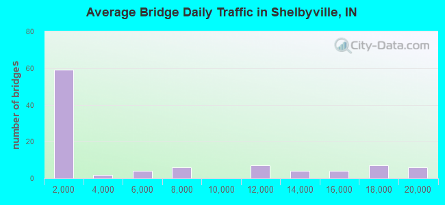
- 512,163Total average daily traffic
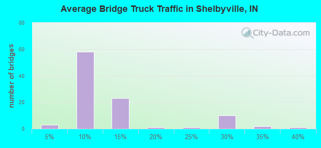
- 80,568Total average daily truck traffic
- National Bridge Inventory (NBI) Registered Bridges for Shelbyville
- No street view available for this location
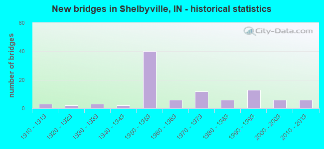
- New bridges - historical statistics
- 31910-1919
- 21920-1929
- 31930-1939
- 21940-1949
- 401950-1959
- 61960-1969
- 121970-1979
- 61980-1989
- 131990-1999
- 62000-2009
- 62010-2019
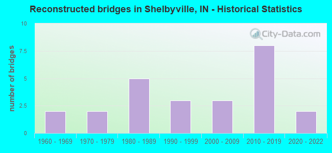
- Reconstructed bridges - Historical Statistics
- 21960-1969
- 21970-1979
- 51980-1989
- 31990-1999
- 32000-2009
- 82010-2019
- 22020-2022
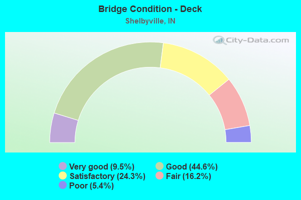
- Bridge Condition - Deck
- 9.5%Very good
- 44.6%Good
- 24.3%Satisfactory
- 16.2%Fair
- 5.4%Poor
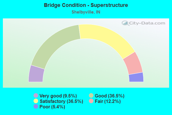
- Bridge Condition - Superstructure
- 9.5%Very good
- 36.5%Good
- 36.5%Satisfactory
- 12.2%Fair
- 5.4%Poor
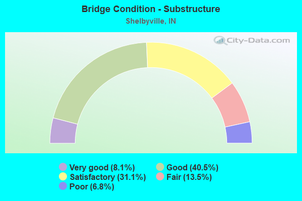
- Bridge Condition - Substructure
- 8.1%Very good
- 40.5%Good
- 31.1%Satisfactory
- 13.5%Fair
- 6.8%Poor
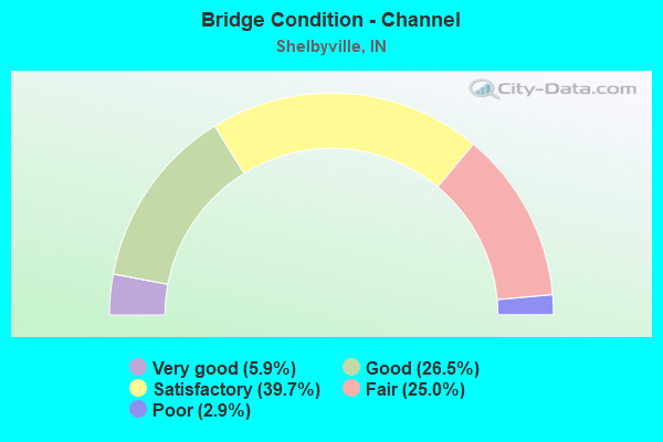
- Bridge Condition - Channel
- 5.9%Very good
- 26.5%Good
- 39.7%Satisfactory
- 25.0%Fair
- 2.9%Poor
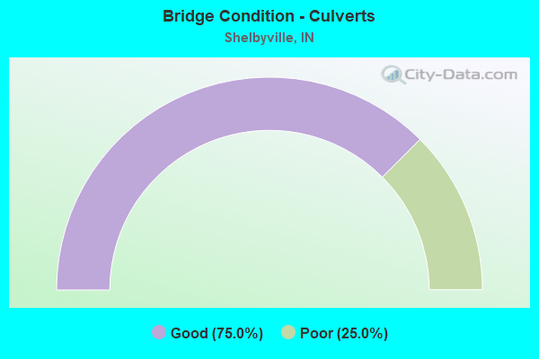
- Bridge Condition - Culverts
- 75.0%Good
- 25.0%Poor
Find on map >> Show street view
Structure Number: 245, Location: 01.97 N SR 44 (Lat: 39.551011, Lng: -85.775669), Route carried "under" structure: Interstate 74, Year Built: 1959, Structure Length: 0. m, Average Daily Traffic: 15,480 (year 2006), Truck Traffic: 28%, Features Intersected: I-74 WB, Facility Carried by Structure: SR 9
Minimum Vertical Clearance: 5.64m (18.50ft), Kilometerpoint: 181.437, Lanes on structure: 4, Lanes under structure: 5, Material/Design: Concrete continuous, Design/Construction: Stringer/Multi-beam, Length of Maximum Span: 26.2m (86.0ft)
Find on map >> Show street view
Structure Number: 301, Location: 11.66 W SR 3 (Lat: 39.497200, Lng: -85.693950), Route carried "under" structure: Interstate 74, Year Built: 1959, Structure Length: 0. m, Average Daily Traffic: 10,730 (year 2004), Truck Traffic: 12%, Features Intersected: I74 WBL, Facility Carried by Structure: SR 244
Minimum Vertical Clearance: 5.08m (16.67ft), Kilometerpoint: 190.675, Lanes on structure: 2, Lanes under structure: 4, Material/Design: Steel continuous, Design/Construction: Stringer/Multi-beam, Length of Maximum Span: 28.1m (92.2ft)
Find on map >> Show street view
Structure Number: 301, Location: 11.66 W SR 3 (Lat: 39.497200, Lng: -85.693950), Route carried "under" structure: Interstate 74, Year Built: 1959, Structure Length: 0. m, Average Daily Traffic: 10,729 (year 2004), Truck Traffic: 12%, Features Intersected: I74 EBL, Facility Carried by Structure: SR 244
Minimum Vertical Clearance: 5.08m (16.67ft), Kilometerpoint: 190.675, Lanes on structure: 2, Lanes under structure: 4, Material/Design: Steel continuous, Design/Construction: Stringer/Multi-beam, Length of Maximum Span: 28.1m (92.2ft)
Find on map >> Show street view
Structure Number: 4477, Location: 04.41 W SR 9 (Lat: 39.594111, Lng: -85.836631), Route carried "under" structure: Interstate 74, Year Built: 1958, Structure Length: 0. m, Average Daily Traffic: 19,973 (year 2016), Truck Traffic: 28%, Features Intersected: I-74 WBL, Facility Carried by Structure: BRANDYWINE ROAD
Minimum Vertical Clearance: 5.33m (17.49ft), Kilometerpoint: 174.340, Lanes on structure: 2, Lanes under structure: 6, Material/Design: Steel continuous, Design/Construction: Stringer/Multi-beam, Length of Maximum Span: 23.9m (78.4ft)
Find on map >> Show street view
Structure Number: 4477, Location: 04.41 W SR 9 (Lat: 39.594111, Lng: -85.836631), Route carried "under" structure: Interstate 74, Year Built: 1958, Structure Length: 0. m, Average Daily Traffic: 19,973 (year 2016), Truck Traffic: 28%, Features Intersected: I-74 EBL, Facility Carried by Structure: BRANDYWINE ROAD
Minimum Vertical Clearance: 5.21m (17.09ft), Kilometerpoint: 174.340, Lanes on structure: 2, Lanes under structure: 6, Material/Design: Steel continuous, Design/Construction: Stringer/Multi-beam, Length of Maximum Span: 23.9m (78.4ft)
Find on map >> Show street view
Structure Number: 4477, Location: 04.41 W SR 9 (Lat: 39.594111, Lng: -85.836631), Route carried "under" structure: ServiceCounty highway , Year Built: 1958, Structure Length: 0. m, Average Daily Traffic: 1,847 (year 2016), Truck Traffic: 10%, Features Intersected: MICHIGAN ROAD, Facility Carried by Structure: BRANDYWINE ROAD
Minimum Vertical Clearance: 5.01m (16.44ft), Kilometerpoint: 174.340, Lanes on structure: 2, Lanes under structure: 6, Material/Design: Steel continuous, Design/Construction: Stringer/Multi-beam, Length of Maximum Span: 23.9m (78.4ft)
Find on map >> Show street view
Structure Number: 448, Location: 03.42 W SR 9 (Lat: 39.584469, Lng: -85.822769), Route carried "under" structure: Interstate 74, Year Built: 1958, Structure Length: 0. m, Average Daily Traffic: 19,973 (year 2016), Truck Traffic: 10%, Features Intersected: I-74 WBL, Facility Carried by Structure: FAIRLAND ROAD
Minimum Vertical Clearance: 5.08m (16.67ft), Kilometerpoint: 175.933, Lanes on structure: 2, Lanes under structure: 4, Material/Design: Steel continuous, Design/Construction: Stringer/Multi-beam, Length of Maximum Span: 24.4m (80.1ft)
Find on map >> Show street view
Structure Number: 448, Location: 03.42 W SR 9 (Lat: 39.584469, Lng: -85.822769), Route carried "under" structure: Interstate 74, Year Built: 1958, Structure Length: 0. m, Average Daily Traffic: 19,973 (year 2016), Truck Traffic: 10%, Features Intersected: I-74 EBL, Facility Carried by Structure: FAIRLAND ROAD
Minimum Vertical Clearance: 5.11m (16.77ft), Kilometerpoint: 175.933, Lanes on structure: 2, Lanes under structure: 4, Material/Design: Steel continuous, Design/Construction: Stringer/Multi-beam, Length of Maximum Span: 24.4m (80.1ft)
Find on map >> Show street view
Structure Number: 4481, Location: 01.39 W SR 9 (Lat: 39.564211, Lng: -85.794981), Route carried "under" structure: Interstate 74, Year Built: 1958, Structure Length: 0. m, Average Daily Traffic: 19,973 (year 2016), Truck Traffic: 10%, Features Intersected: I-74 EBL, Facility Carried by Structure: MICHIGAN ROAD
Minimum Vertical Clearance: 5.74m (18.83ft), Kilometerpoint: 179.200, Lanes on structure: 2, Lanes under structure: 4, Material/Design: Concrete continuous, Design/Construction: Stringer/Multi-beam, Length of Maximum Span: 23.0m (75.5ft)
Find on map >> Show street view
Structure Number: 4481, Location: 01.39 W SR 9 (Lat: 39.564211, Lng: -85.794981), Route carried "under" structure: Interstate 74, Year Built: 1958, Structure Length: 0. m, Average Daily Traffic: 19,973 (year 2016), Truck Traffic: 10%, Features Intersected: I-74 WBL, Facility Carried by Structure: MICHIGAN ROAD
Minimum Vertical Clearance: 5.56m (18.24ft), Kilometerpoint: 179.200, Lanes on structure: 2, Lanes under structure: 4, Material/Design: Concrete continuous, Design/Construction: Stringer/Multi-beam, Length of Maximum Span: 23.0m (75.5ft)
Find on map >> Show street view
Structure Number: 4484, Location: 01.34 E SR 9 (Lat: 39.539539, Lng: -85.755300), Route carried "under" structure: Interstate 74, Year Built: 1959, Structure Length: 0. m, Average Daily Traffic: 13,523 (year 2004), Truck Traffic: 10%, Features Intersected: I-74 WBL, Facility Carried by Structure: KNIGHTSTOWN ROAD
Minimum Vertical Clearance: 4.88m (16.01ft), Kilometerpoint: 183.594, Lanes on structure: 2, Lanes under structure: 4, Material/Design: Steel continuous, Design/Construction: Stringer/Multi-beam, Length of Maximum Span: 21.0m (68.9ft)
Find on map >> Show street view
Structure Number: 4484, Location: 01.34 E SR 9 (Lat: 39.539539, Lng: -85.755300), Route carried "under" structure: Interstate 74, Year Built: 1959, Structure Length: 0. m, Average Daily Traffic: 13,524 (year 2004), Truck Traffic: 10%, Features Intersected: I-74 EBL, Facility Carried by Structure: KNIGHTSTOWN ROAD
Minimum Vertical Clearance: 4.93m (16.17ft), Kilometerpoint: 183.594, Lanes on structure: 2, Lanes under structure: 4, Material/Design: Steel continuous, Design/Construction: Stringer/Multi-beam, Length of Maximum Span: 21.0m (68.9ft)
Find on map >> Show street view
Structure Number: 4485, Location: 00.86 W SR 44 (Lat: 39.534339, Lng: -85.748439), Route carried "under" structure: Interstate 74, Year Built: 1959, Structure Length: 0. m, Average Daily Traffic: 13,524 (year 2004), Truck Traffic: 10%, Features Intersected: I-74 EBL, Facility Carried by Structure: RUSHVILLE ROAD
Minimum Vertical Clearance: 5.01m (16.44ft), Kilometerpoint: 184.415, Lanes on structure: 2, Lanes under structure: 4, Material/Design: Steel continuous, Design/Construction: Stringer/Multi-beam, Length of Maximum Span: 23.8m (78.1ft)
Find on map >> Show street view
Structure Number: 4485, Location: 00.86 W SR 44 (Lat: 39.534339, Lng: -85.748439), Route carried "under" structure: Interstate 74, Year Built: 1959, Structure Length: 0. m, Average Daily Traffic: 13,523 (year 2004), Truck Traffic: 10%, Features Intersected: I-74 WBL, Facility Carried by Structure: RUSHVILLE ROAD
Minimum Vertical Clearance: 5.01m (16.44ft), Kilometerpoint: 184.415, Lanes on structure: 2, Lanes under structure: 4, Material/Design: Steel continuous, Design/Construction: Stringer/Multi-beam, Length of Maximum Span: 23.8m (78.1ft)
Find on map >> Show street view
Structure Number: 4488, Location: 02.71 E SR-9 (Lat: 39.526661, Lng: -85.736439), Route carried "under" structure: State highway 44, Year Built: 1959, Structure Length: 0. m, Average Daily Traffic: 6,367 (year 2004), Truck Traffic: 5%, Features Intersected: SR 44 WBL, Facility Carried by Structure: I-74 EB
Minimum Vertical Clearance: 7.09m (23.26ft), Kilometerpoint: 20.085, Lanes on structure: 3, Lanes under structure: 4, Material/Design: Steel continuous, Design/Construction: Stringer/Multi-beam, Length of Maximum Span: 19.4m (63.6ft)
Find on map >> Show street view
Structure Number: 4488, Location: 02.71 E SR-9 (Lat: 39.526661, Lng: -85.736439), Route carried "under" structure: State highway 44, Year Built: 1959, Structure Length: 0. m, Average Daily Traffic: 6,367 (year 2004), Truck Traffic: 5%, Features Intersected: SR 44 EB, Facility Carried by Structure: I-74 EB
Minimum Vertical Clearance: 7.11m (23.33ft), Kilometerpoint: 20.085, Lanes on structure: 3, Lanes under structure: 4, Material/Design: Steel continuous, Design/Construction: Stringer/Multi-beam, Length of Maximum Span: 19.4m (63.6ft)
Find on map >> Show street view
Structure Number: 4489, Location: 02.71 E SR-9 (Lat: 39.526419, Lng: -85.736089), Route carried "under" structure: State highway 44, Year Built: 1959, Structure Length: 0. m, Average Daily Traffic: 6,367 (year 2004), Truck Traffic: 5%, Features Intersected: SR 44 WBL, Facility Carried by Structure: I-74 WB
Minimum Vertical Clearance: 6.83m (22.41ft), Kilometerpoint: 20.117, Lanes on structure: 3, Lanes under structure: 4, Material/Design: Steel continuous, Design/Construction: Stringer/Multi-beam, Length of Maximum Span: 19.4m (63.6ft)
Find on map >> Show street view
Structure Number: 4489, Location: 02.71 E SR-9 (Lat: 39.526419, Lng: -85.736089), Route carried "under" structure: State highway 44, Year Built: 1959, Structure Length: 0. m, Average Daily Traffic: 6,367 (year 2004), Truck Traffic: 5%, Features Intersected: SR 44 EBL, Facility Carried by Structure: I-74 WB
Minimum Vertical Clearance: 6.81m (22.34ft), Kilometerpoint: 20.117, Lanes on structure: 3, Lanes under structure: 4, Material/Design: Steel continuous, Design/Construction: Stringer/Multi-beam, Length of Maximum Span: 19.4m (63.6ft)
Find on map >> Show street view
Structure Number: 4492, Location: 00.87 E SR 44 (Lat: 39.519069, Lng: -85.722700), Route carried "under" structure: Interstate 74, Year Built: 1959, Structure Length: 0. m, Average Daily Traffic: 10,871 (year 2004), Truck Traffic: 10%, Features Intersected: I-74 EBL, Facility Carried by Structure: BLUE RIDGE ROAD
Minimum Vertical Clearance: 5.05m (16.57ft), Kilometerpoint: 187.199, Lanes on structure: 2, Lanes under structure: 4, Material/Design: Steel continuous, Design/Construction: Stringer/Multi-beam, Length of Maximum Span: 24.2m (79.4ft)
Find on map >> Show street view
Structure Number: 4492, Location: 00.87 E SR 44 (Lat: 39.519069, Lng: -85.722700), Route carried "under" structure: Interstate 74, Year Built: 1959, Structure Length: 0. m, Average Daily Traffic: 10,872 (year 2004), Truck Traffic: 10%, Features Intersected: I-74 WBL, Facility Carried by Structure: BLUE RIDGE ROAD
Minimum Vertical Clearance: 4.90m (16.08ft), Kilometerpoint: 187.199, Lanes on structure: 2, Lanes under structure: 4, Material/Design: Steel continuous, Design/Construction: Stringer/Multi-beam, Length of Maximum Span: 24.2m (79.4ft)