Bridge Statistics for Sioux Falls, South Dakota (SD)
Condition, Traffic, Stress, Structural Evaluation, Project Costs
- National Bridge Inventory (NBI) Statistics
- 248Number of bridges
- 3,396ft / 1,035mTotal length
- $53,131,000Total costs
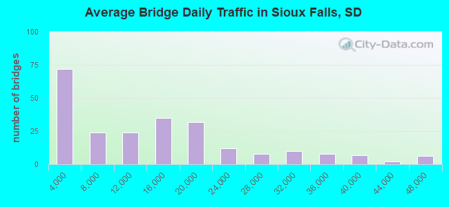
- 3,177,932Total average daily traffic
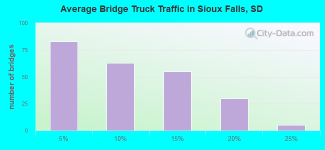
- 297,651Total average daily truck traffic
- National Bridge Inventory (NBI) Registered Bridges for Sioux Falls
- No street view available for this location
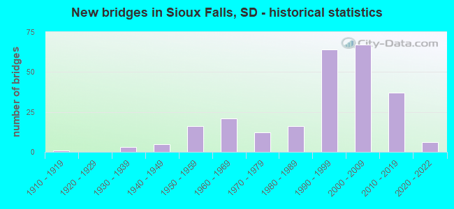
- New bridges - historical statistics
- 11910-1919
- 31930-1939
- 51940-1949
- 161950-1959
- 211960-1969
- 121970-1979
- 161980-1989
- 641990-1999
- 672000-2009
- 372010-2019
- 62020-2022
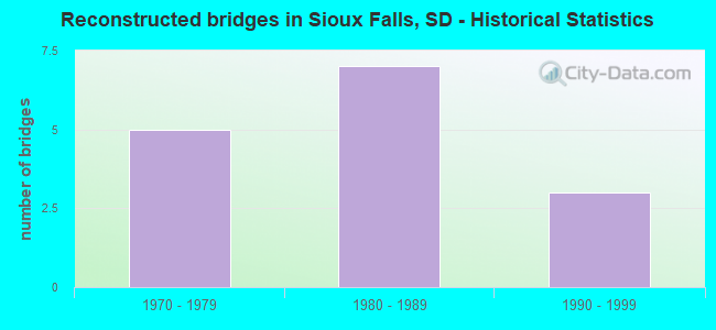
- Reconstructed bridges - Historical Statistics
- 51970-1979
- 71980-1989
- 31990-1999
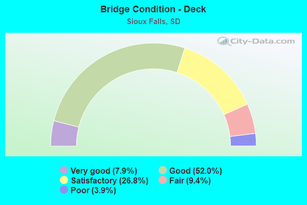
- Bridge Condition - Deck
- 7.9%Very good
- 52.0%Good
- 26.8%Satisfactory
- 9.4%Fair
- 3.9%Poor
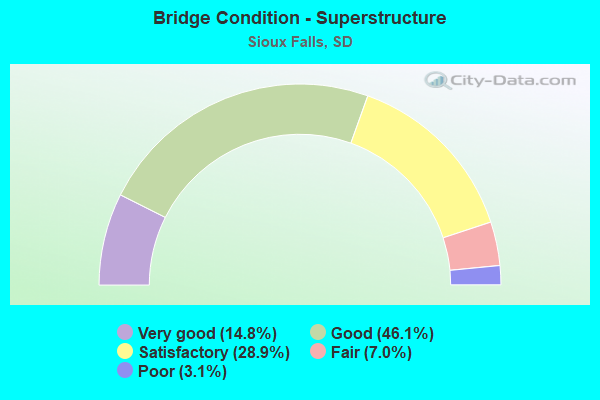
- Bridge Condition - Superstructure
- 14.8%Very good
- 46.1%Good
- 28.9%Satisfactory
- 7.0%Fair
- 3.1%Poor
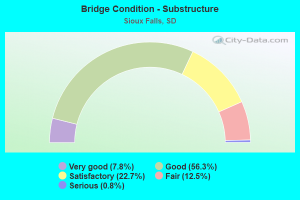
- Bridge Condition - Substructure
- 7.8%Very good
- 56.3%Good
- 22.7%Satisfactory
- 12.5%Fair
- 0.8%Serious
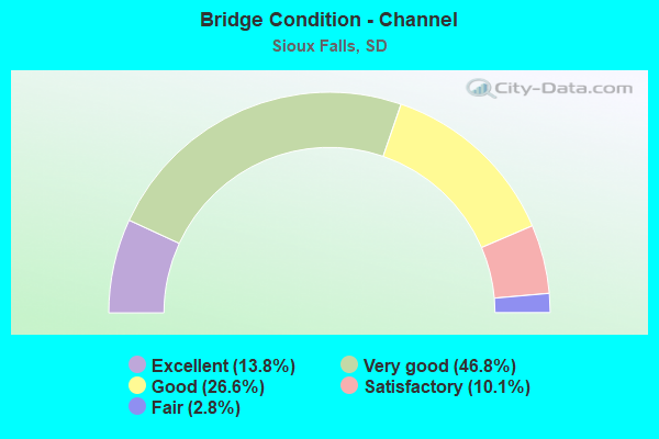
- Bridge Condition - Channel
- 13.8%Excellent
- 46.8%Very good
- 26.6%Good
- 10.1%Satisfactory
- 2.8%Fair
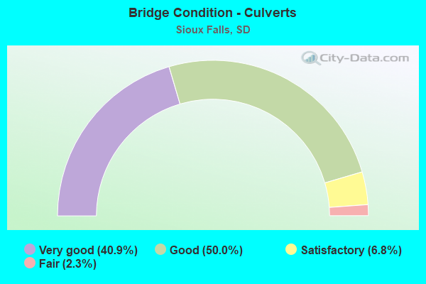
- Bridge Condition - Culverts
- 40.9%Very good
- 50.0%Good
- 6.8%Satisfactory
- 2.3%Fair
Find on map >> Show street view
Structure Number: 5016416, Location: 3.5N & 1.4E ELLIS (Lat: 43.616356, Lng: -96.800908), Route carried "on" structure: County highway , Year Built: 1987, Status: Open, Structure Length: 1.58m (5.18ft), Average Daily Traffic: 45 (year 2021), Truck Traffic: 2%, Average Future Daily Traffic: 50 (year 2036), Features Intersected: TRIB TO WILLOW CK, Facility Carried by Structure: 260TH STREET
Minimum Vertical Clearance: 30+ m (98+ ft), Kilometerpoint: 0.000, Lanes on structure: 2, Owner: County Highway Agency, Approaching Roadway Width: 7.3m (24.0ft), Material/Design: Prestressed concrete, Design/Construction: Tee Beam, Number Of Spans In Main Unit: 1, Length of Maximum Span: 15.2m (49.9ft), Curb-To-Curb Width: 9.6m (31.5ft), Out-to-Out Width: 9.8m (32.2ft)
Condition: Deck: Good, Superstructure: Good, Substructure: Good, Channel: Good, Operating Rating: 32.7 metric tons, Method Used To Determine Operating Rating: Field evaluation and documented engineering judgment, Inventory Rating: 19.6 metric tons, Method Used To Determine Inventory Rating: Field evaluation and documented engineering judgment, Structural Evaluation: Somewhat better than minimum adequacy, Deck Geometry: Better than present minimum criteria, Waterway Adequacy: Equal to present desirable criteria, Approach Roadway Alignment: Equal to present desirable criteria, Length Of Structure Improvement: 2.27m (7.45ft), Designated Inspection Frequency: Every 24 months, Inspection Date: July 2021, Bridge Improvement Cost: $334,000, Roadway Improvement Cost: $33,000, Total Project Cost: $543,000 ( Estimate for 2017), Deck Structure Type: Concrete Precast Panels, Wearing Surface/Protective System: Wearing Surface: Monolithic Concrete
Find on map >> Show street view
Structure Number: 5016819, Location: W of Marion Rd - SF (Lat: 43.572875, Lng: -96.794417), Route carried "on" structure: City street , Year Built: 2013, Status: Open, Structure Length: 1.68m (5.51ft), Average Daily Traffic: 525 (year 2019), Truck Traffic: 3%, Average Future Daily Traffic: 525 (year 2032), Design Load: HL 93, Features Intersected: Trib. to Skunk Creek, Facility Carried by Structure: Maple Street
Minimum Vertical Clearance: 30+ m (98+ ft), Kilometerpoint: 0.000, Lanes on structure: 4, Owner: City or Municipal Highway Agency, Approaching Roadway Width: 21.0m (68.9ft), Skew: 20 degrees, Material/Design: Concrete, Design/Construction: Culvert, Number Of Spans In Main Unit: 4, Number Of Approach Spans: 1, Length of Maximum Span: 3.7m (12.1ft), Curb or Sidewalk Widths: Left: 3.5m (11.5ft), Right: 3.5m (11.5ft)
Condition: Channel: Very good, Culverts: Good, Operating Rating: 36.2 metric tons, Method Used To Determine Operating Rating: Load and Resistance Factor (LRFR), Inventory Rating: 27.9 metric tons, Method Used To Determine Inventory Rating: Load and Resistance Factor (LRFR), Structural Evaluation: Better than present minimum criteria, Waterway Adequacy: Superior to present desirable criteria, Approach Roadway Alignment: Superior to present desirable criteria, Designated Inspection Frequency: Every 48 months, Inspection Date: September 2021
Find on map >> Show street view
Structure Number: 50170164, Location: 1.1 W I 29 INTERCH (Lat: 43.611086, Lng: -96.790992), Route carried "on" structure: County highway , Year Built: 2010, Status: Open, Structure Length: 7.99m (26.21ft), Average Daily Traffic: 450 (year 2020), Truck Traffic: 5%, Average Future Daily Traffic: 450 (year 2040), Design Load: HS 25 or greater, Features Intersected: I090, Facility Carried by Structure: N MARION RD
Minimum Vertical Clearance: 30+ m (98+ ft), Kilometerpoint: 0.000, Lanes on structure: 2, Lanes under structure: 4, Owner: State Highway Agency, Approaching Roadway Width: 24.4m (80.1ft), Skew: 11 degrees, Material/Design: Prestressed concrete continuous, Design/Construction: Stringer/Multi-beam, Number Of Spans In Main Unit: 2, Length of Maximum Span: 39.9m (130.9ft), Curb or Sidewalk Widths: Left: 0.0m, Right: 2.4m (7.9ft), Curb-To-Curb Width: 24.4m (80.1ft), Out-to-Out Width: 27.9m (91.5ft)
Condition: Deck: Good, Superstructure: Good, Substructure: Good, Operating Rating: 89.8 metric tons, Method Used To Determine Operating Rating: Load Factor (LF), Inventory Rating: 62.4 metric tons, Method Used To Determine Inventory Rating: Load Factor (LF), Structural Evaluation: Better than present minimum criteria, Deck Geometry: Superior to present desirable criteria, Underclear: Better than present minimum criteria, Approach Roadway Alignment: Superior to present desirable criteria, Designated Inspection Frequency: Every 24 months, Inspection Date: October 2020, Deck Structure Type: Concrete Cast-file-Place, Wearing Surface/Protective System: Wearing Surface: Integral Concrete, Deck Protection: Epoxy Coated Reinforcing
Find on map >> Show street view
Structure Number: 50170188, Location: 0.15N of Maple Street-SF (Lat: 43.569467, Lng: -96.791031), Route carried "on" structure: City street , Year Built: 2014, Status: Open, Structure Length: 1.62m (5.31ft), Average Daily Traffic: 50 (year 2019), Truck Traffic: 2%, Average Future Daily Traffic: 50 (year 2032), Design Load: HS 20+Mod, Features Intersected: Trib. to Skunk Creek, Facility Carried by Structure: N. Marion Road
Minimum Vertical Clearance: 30+ m (98+ ft), Kilometerpoint: 0.000, Lanes on structure: 2, Owner: City or Municipal Highway Agency, Approaching Roadway Width: 11.0m (36.1ft), Material/Design: Concrete, Design/Construction: Culvert, Number Of Spans In Main Unit: 4, Length of Maximum Span: 3.7m (12.1ft)
Condition: Channel: Good, Culverts: Good, Operating Rating: 89.8 metric tons, Method Used To Determine Operating Rating: Field evaluation and documented engineering judgment, Inventory Rating: 89.8 metric tons, Method Used To Determine Inventory Rating: Field evaluation and documented engineering judgment, Structural Evaluation: Better than present minimum criteria, Waterway Adequacy: Better than present minimum criteria, Approach Roadway Alignment: Equal to present desirable criteria, Designated Inspection Frequency: Every 48 months, Inspection Date: October 2018
Find on map >> Show street view
Structure Number: 50170218, Location: north of Silver Valley Dr (Lat: 43.533878, Lng: -96.790897), Route carried "on" structure: City street , Year Built: 2003, Status: Open, Structure Length: 7.70m (25.26ft), Average Daily Traffic: 15,400 (year 2019), Truck Traffic: 3%, Average Future Daily Traffic: 22,160 (year 2032), Design Load: HS 20+Mod, Features Intersected: Skunk Creek, Facility Carried by Structure: S. Marion Road
Minimum Vertical Clearance: 30+ m (98+ ft), Kilometerpoint: 0.000, Lanes on structure: 5, Owner: City or Municipal Highway Agency, Approaching Roadway Width: 20.1m (65.9ft), Material/Design: Concrete continuous, Design/Construction: Slab, Number Of Spans In Main Unit: 5, Length of Maximum Span: 16.2m (53.1ft), Curb or Sidewalk Widths: Left: 0.0m, Right: 3.1m (10.2ft), Curb-To-Curb Width: 20.1m (65.9ft), Out-to-Out Width: 24.3m (79.7ft)
Condition: Deck: Fair, Superstructure: Satisfactory, Substructure: Good, Channel: Excellent, Operating Rating: 47.8 metric tons, Method Used To Determine Operating Rating: Load and Resistance Factor (LRFR), Inventory Rating: 36.8 metric tons, Method Used To Determine Inventory Rating: Load and Resistance Factor (LRFR), Structural Evaluation: Equal to present minimum criteria, Deck Geometry: Somewhat better than minimum adequacy, Waterway Adequacy: Superior to present desirable criteria, Approach Roadway Alignment: Superior to present desirable criteria, Designated Inspection Frequency: Every 24 months, Inspection Date: September 2020, Deck Structure Type: Concrete Cast-file-Place, Wearing Surface/Protective System: Wearing Surface: Monolithic Concrete, Deck Protection: Epoxy Coated Reinforcing
Find on map >> Show street view
Structure Number: 5017224, Location: INTERSECTION 57TH & I029 (Lat: 43.500289, Lng: -96.787622), Route carried "on" structure: City street , Year Built: 2001, Status: Open, Structure Length: 6.97m (22.87ft), Average Daily Traffic: 19,400 (year 2020), Truck Traffic: 8%, Average Future Daily Traffic: 21,000 (year 2040), Design Load: HS 25 or greater, Features Intersected: I029, Facility Carried by Structure: W 57TH ST
Minimum Vertical Clearance: 30+ m (98+ ft), Kilometerpoint: 0.000, Lanes on structure: 4, Lanes under structure: 4, Owner: State Highway Agency, Approaching Roadway Width: 19.8m (65.0ft), Skew: 2 degrees, Material/Design: Prestressed concrete, Design/Construction: Stringer/Multi-beam, Number Of Spans In Main Unit: 2, Length of Maximum Span: 33.5m (109.9ft), Curb or Sidewalk Widths: Left: 2.4m (7.9ft), Right: 1.5m (4.9ft), Curb-To-Curb Width: 15.8m (51.8ft), Out-to-Out Width: 21.1m (69.2ft)
Condition: Deck: Satisfactory, Superstructure: Satisfactory, Substructure: Good, Operating Rating: 92.9 metric tons, Method Used To Determine Operating Rating: Load Factor (LF), Inventory Rating: 55.8 metric tons, Method Used To Determine Inventory Rating: Load Factor (LF), Structural Evaluation: Equal to present minimum criteria, Deck Geometry: Meets minimum limits, Underclear: Better than present minimum criteria, Approach Roadway Alignment: Equal to present desirable criteria, Designated Inspection Frequency: Every 24 months, Inspection Date: September 2021, Deck Structure Type: Concrete Cast-file-Place, Wearing Surface/Protective System: Deck Protection: Epoxy Coated Reinforcing
Find on map >> Show street view
Structure Number: 50173235, Location: 0.5 SW 41ST INTERCH (Lat: 43.507569, Lng: -96.782736), Route carried "on" structure: City street , Year Built: 1981, Status: Open, Structure Length: 10.00m (32.81ft), Average Daily Traffic: 11,280 (year 2020), Truck Traffic: 5%, Average Future Daily Traffic: 14,505 (year 2040), Design Load: HS 20+Mod, Features Intersected: I029, Facility Carried by Structure: W 49TH ST
Minimum Vertical Clearance: 30+ m (98+ ft), Kilometerpoint: 0.000, Lanes on structure: 4, Lanes under structure: 4, Owner: State Highway Agency, Approaching Roadway Width: 12.2m (40.0ft), Skew: 2 degrees, Material/Design: Prestressed concrete continuous, Design/Construction: Stringer/Multi-beam, Number Of Spans In Main Unit: 4, Length of Maximum Span: 29.0m (95.1ft), Curb or Sidewalk Widths: Left: 1.5m (4.9ft), Right: 0.0m, Curb-To-Curb Width: 15.8m (51.8ft), Out-to-Out Width: 18.4m (60.4ft)
Condition: Deck: Satisfactory, Superstructure: Satisfactory, Substructure: Satisfactory, Operating Rating: 59.9 metric tons, Method Used To Determine Operating Rating: Load Factor (LF), Inventory Rating: 35.8 metric tons, Method Used To Determine Inventory Rating: Load Factor (LF), Structural Evaluation: Equal to present minimum criteria, Deck Geometry: Meets minimum limits, Underclear: Equal to present minimum criteria, Approach Roadway Alignment: Better than present minimum criteria, Designated Inspection Frequency: Every 24 months, Inspection Date: September 2021, Deck Structure Type: Concrete Cast-file-Place, Wearing Surface/Protective System: Wearing Surface: Epoxy Overlay, Membrane: Epoxy, Deck Protection: Epoxy Coated Reinforcing
Find on map >> Show street view
Structure Number: 50174222, Location: .1 W OF I29-26TH ST.INTER (Lat: 43.527539, Lng: -96.782431), Route carried "on" structure: ServiceInterstate 29, Year Built: 1996, Status: Open, Structure Length: 1.50m (4.92ft), Average Daily Traffic: 8,300 (year 2020), Truck Traffic: 1%, Average Future Daily Traffic: 8,300 (year 2040), Design Load: HS 20+Mod, Features Intersected: DRAINAGE DITCH
Minimum Vertical Clearance: 30+ m (98+ ft), Kilometerpoint: 125.722, Lanes on structure: 4, Owner: State Highway Agency, Approaching Roadway Width: 27.4m (89.9ft), Material/Design: Concrete continuous, Design/Construction: Culvert, Number Of Spans In Main Unit: 5, Length of Maximum Span: 3.0m (9.8ft)
Condition: Channel: Very good, Culverts: Very good, Structural Evaluation: Equal to present desirable criteria, Waterway Adequacy: Superior to present desirable criteria, Approach Roadway Alignment: Superior to present desirable criteria, Designated Inspection Frequency: Every 48 months, Inspection Date: October 2018
Find on map >> Show street view
Structure Number: 50175207, Location: 0.3 N 12TH ST INTERCH (Lat: 43.547778, Lng: -96.780633), Route carried "on" structure: Interstate 29, Year Built: 2004, Status: Open, Structure Length: 2.87m (9.42ft), Average Daily Traffic: 29,005 (year 2021), Truck Traffic: 11%, Average Future Daily Traffic: 45,712 (year 2041), Design Load: HS 25 or greater, Features Intersected: ELLIS AND EASTERN RR
Minimum Vertical Clearance: 30+ m (98+ ft), Kilometerpoint: 128.007, Lanes on structure: 4, Base Highway Network: Yes, Owner: State Highway Agency, Approaching Roadway Width: 25.5m (83.7ft), Material/Design: Steel, Design/Construction: Stringer/Multi-beam, Number Of Spans In Main Unit: 1, Length of Maximum Span: 27.4m (89.9ft), Curb-To-Curb Width: 25.5m (83.7ft), Out-to-Out Width: 26.3m (86.3ft)
Condition: Deck: Good, Superstructure: Satisfactory, Substructure: Good, Operating Rating: 87.0 metric tons, Method Used To Determine Operating Rating: Load Factor (LF), Inventory Rating: 52.1 metric tons, Method Used To Determine Inventory Rating: Load Factor (LF), Structural Evaluation: Equal to present minimum criteria, Deck Geometry: Superior to present desirable criteria, Underclear: Superior to present desirable criteria, Approach Roadway Alignment: Superior to present desirable criteria, Designated Inspection Frequency: Every 24 months, Inspection Date: December 2020, Deck Structure Type: Concrete Cast-file-Place, Wearing Surface/Protective System: Wearing Surface: Integral Concrete, Deck Protection: Other
Find on map >> Show street view
Structure Number: 5017521, Location: 12TH ST INTERCHANGE (Lat: 43.544450, Lng: -96.780494), Route carried "on" structure: Interstate 29, Year Built: 2006, Status: Open, Structure Length: 11.40m (37.40ft), Average Daily Traffic: 29,005 (year 2021), Truck Traffic: 11%, Average Future Daily Traffic: 45,712 (year 2041), Design Load: HS 25 or greater, Features Intersected: W 12TH ST
Minimum Vertical Clearance: 30+ m (98+ ft), Kilometerpoint: 127.557, Lanes on structure: 3, Lanes under structure: 30, Base Highway Network: Yes, Owner: State Highway Agency, Approaching Roadway Width: 17.1m (56.1ft), Material/Design: Steel continuous, Design/Construction: Stringer/Multi-beam, Number Of Spans In Main Unit: 3, Length of Maximum Span: 58.2m (190.9ft), Curb-To-Curb Width: 17.1m (56.1ft), Out-to-Out Width: 17.9m (58.7ft)
Condition: Deck: Good, Superstructure: Satisfactory, Substructure: Good, Operating Rating: 76.9 metric tons, Method Used To Determine Operating Rating: Load Factor (LF), Inventory Rating: 46.1 metric tons, Method Used To Determine Inventory Rating: Load Factor (LF), Structural Evaluation: Equal to present minimum criteria, Deck Geometry: Equal to present minimum criteria, Underclear: Somewhat better than minimum adequacy, Approach Roadway Alignment: Superior to present desirable criteria, Designated Inspection Frequency: Every 24 months, Inspection Date: October 2020, Deck Structure Type: Concrete Cast-file-Place, Wearing Surface/Protective System: Wearing Surface: Integral Concrete, Deck Protection: Epoxy Coated Reinforcing
Find on map >> Show street view
Structure Number: 50175219, Location: 0.3 N 26TH ST INTERCH (Lat: 43.531164, Lng: -96.780619), Route carried "on" structure: Interstate 29, Year Built: 1989, Year Reconstructed: 1996, Status: Open, Structure Length: 8.66m (28.41ft), Average Daily Traffic: 30,365 (year 2021), Truck Traffic: 12%, Average Future Daily Traffic: 47,855 (year 2041), Design Load: HS 20+Mod, Features Intersected: SKUNK CK
Minimum Vertical Clearance: 30+ m (98+ ft), Kilometerpoint: 126.140, Lanes on structure: 4, Base Highway Network: Yes, Owner: State Highway Agency, Approaching Roadway Width: 20.7m (67.9ft), Skew: 2 degrees, Material/Design: Prestressed concrete continuous, Design/Construction: Stringer/Multi-beam, Number Of Spans In Main Unit: 5, Length of Maximum Span: 17.7m (58.1ft), Curb-To-Curb Width: 20.7m (67.9ft), Out-to-Out Width: 21.5m (70.5ft)
Condition: Deck: Satisfactory, Superstructure: Good, Substructure: Satisfactory, Channel: Very good, Operating Rating: 53.9 metric tons, Method Used To Determine Operating Rating: Load Factor (LF), Inventory Rating: 32.3 metric tons, Method Used To Determine Inventory Rating: Load Factor (LF), Structural Evaluation: Equal to present minimum criteria, Deck Geometry: Equal to present minimum criteria, Waterway Adequacy: Equal to present desirable criteria, Approach Roadway Alignment: Equal to present desirable criteria, Designated Inspection Frequency: Every 24 months, Inspection Date: June 2020, Deck Structure Type: Concrete Cast-file-Place, Wearing Surface/Protective System: Wearing Surface: Epoxy Overlay, Membrane: Epoxy, Deck Protection: Epoxy Coated Reinforcing
Find on map >> Show street view
Structure Number: 50175222, Location: 26TH ST INTERCHANGE (Lat: 43.527108, Lng: -96.779986), Route carried "on" structure: City street , Year Built: 1996, Status: Open, Structure Length: 8.21m (26.94ft), Average Daily Traffic: 20,500 (year 2020), Truck Traffic: 1%, Average Future Daily Traffic: 20,500 (year 2040), Design Load: HS 25 or greater, Features Intersected: I029, Facility Carried by Structure: 26TH ST
Minimum Vertical Clearance: 30+ m (98+ ft), Kilometerpoint: 0.000, Lanes on structure: 4, Lanes under structure: 6, Owner: State Highway Agency, Approaching Roadway Width: 28.0m (91.9ft), Skew: 21 degrees, Material/Design: Prestressed concrete continuous, Design/Construction: Stringer/Multi-beam, Number Of Spans In Main Unit: 2, Length of Maximum Span: 40.7m (133.5ft), Curb or Sidewalk Widths: Left: 0.0m, Right: 1.8m (5.9ft), Curb-To-Curb Width: 27.2m (89.2ft), Out-to-Out Width: 28.0m (91.9ft)
Condition: Deck: Good, Superstructure: Good, Substructure: Good, Operating Rating: 71.9 metric tons, Method Used To Determine Operating Rating: Load Factor (LF), Inventory Rating: 43.1 metric tons, Method Used To Determine Inventory Rating: Load Factor (LF), Structural Evaluation: Better than present minimum criteria, Deck Geometry: Superior to present desirable criteria, Underclear: Equal to present minimum criteria, Approach Roadway Alignment: Better than present minimum criteria, Designated Inspection Frequency: Every 24 months, Inspection Date: June 2021, Deck Structure Type: Concrete Cast-file-Place, Wearing Surface/Protective System: Wearing Surface: Low Slump Concrete, Deck Protection: Epoxy Coated Reinforcing
Find on map >> Show street view
Structure Number: 5017523, Location: 41ST INTERCHANGE (Lat: 43.514836, Lng: -96.780000), Route carried "on" structure: City street , Year Built: 1979, Status: Open, Structure Length: 7.38m (24.21ft), Average Daily Traffic: 31,921 (year 2020), Truck Traffic: 1%, Average Future Daily Traffic: 31,921 (year 2040), Design Load: HL 93, Features Intersected: I029, Facility Carried by Structure: 41ST ST
Minimum Vertical Clearance: 30+ m (98+ ft), Kilometerpoint: 0.000, Lanes on structure: 6, Lanes under structure: 4, Owner: State Highway Agency, Approaching Roadway Width: 24.4m (80.1ft), Material/Design: Steel continuous, Design/Construction: Stringer/Multi-beam, Number Of Spans In Main Unit: 2, Length of Maximum Span: 37.8m (124.0ft), Curb or Sidewalk Widths: Left: 1.5m (4.9ft), Right: 1.5m (4.9ft), Curb-To-Curb Width: 24.4m (80.1ft), Out-to-Out Width: 28.8m (94.5ft)
Condition: Deck: Fair, Superstructure: Satisfactory, Substructure: Satisfactory, Operating Rating: 65.4 metric tons, Method Used To Determine Operating Rating: Load and Resistance Factor (LRFR), Inventory Rating: 39.2 metric tons, Method Used To Determine Inventory Rating: Load and Resistance Factor (LRFR), Structural Evaluation: Equal to present minimum criteria, Deck Geometry: Somewhat better than minimum adequacy, Underclear: Equal to present minimum criteria, Approach Roadway Alignment: Better than present minimum criteria, Designated Inspection Frequency: Every 24 months, Inspection Date: Febuary 2021, Deck Structure Type: Concrete Cast-file-Place, Wearing Surface/Protective System: Wearing Surface: Epoxy Overlay, Membrane: Epoxy, Deck Protection: Epoxy Coated Reinforcing
Find on map >> Show street view
Structure Number: 501761, Location: 6.3 N I 90 INTERCH (Lat: 43.703381, Lng: -96.781161), Route carried "on" structure: Interstate 29, Year Built: 1963, Status: Open, Structure Length: 3.63m (11.91ft), Average Daily Traffic: 10,625 (year 2021), Truck Traffic: 15%, Average Future Daily Traffic: 15,991 (year 2041), Design Load: HS 20+Mod, Features Intersected: 254 ST (FAS 6148)
Minimum Vertical Clearance: 30+ m (98+ ft), Kilometerpoint: 145.630, Lanes on structure: 2, Lanes under structure: 2, Base Highway Network: Yes, Owner: State Highway Agency, Approaching Roadway Width: 11.6m (38.1ft), Material/Design: Concrete continuous, Design/Construction: Slab, Number Of Spans In Main Unit: 3, Length of Maximum Span: 13.1m (43.0ft), Curb-To-Curb Width: 11.6m (38.1ft), Out-to-Out Width: 12.9m (42.3ft)
Condition: Deck: Good, Superstructure: Good, Substructure: Good, Operating Rating: 66.5 metric tons, Method Used To Determine Operating Rating: Load Factor (LF), Inventory Rating: 39.8 metric tons, Method Used To Determine Inventory Rating: Load Factor (LF), Structural Evaluation: Better than present minimum criteria, Deck Geometry: Equal to present minimum criteria, Underclear: High priority of corrective action, Approach Roadway Alignment: Equal to present desirable criteria, Designated Inspection Frequency: Every 24 months, Inspection Date: August 2020, Deck Structure Type: Concrete Cast-file-Place, Wearing Surface/Protective System: Wearing Surface: Low Slump Concrete
Find on map >> Show street view
Structure Number: 50176175, Location: 0.5S of W. 60th Street N. (Lat: 43.595286, Lng: -96.779492), Route carried "on" structure: City street , Year Built: 2001, Status: Open, Structure Length: 1.27m (4.17ft), Average Daily Traffic: 1,328 (year 2019), Truck Traffic: 8%, Average Future Daily Traffic: 2,036 (year 2032), Design Load: HS 20+Mod, Features Intersected: Trib. to Skunk Creek, Facility Carried by Structure: N. Career Avenue
Minimum Vertical Clearance: 30+ m (98+ ft), Kilometerpoint: 0.000, Lanes on structure: 2, Owner: City or Municipal Highway Agency, Approaching Roadway Width: 15.2m (49.9ft), Material/Design: Concrete, Design/Construction: Culvert, Number Of Spans In Main Unit: 4, Length of Maximum Span: 3.0m (9.8ft)
Condition: Channel: Very good, Culverts: Good, Operating Rating: 40.9 metric tons, Method Used To Determine Operating Rating: Load and Resistance Factor (LRFR), Inventory Rating: 31.6 metric tons, Method Used To Determine Inventory Rating: Load and Resistance Factor (LRFR), Structural Evaluation: Better than present minimum criteria, Waterway Adequacy: Superior to present desirable criteria, Approach Roadway Alignment: Superior to present desirable criteria, Designated Inspection Frequency: Every 48 months, Inspection Date: September 2021
Find on map >> Show street view
Structure Number: 50176207, Location: 0.3 N 12TH ST INTERCH (Lat: 43.547781, Lng: -96.780217), Route carried "on" structure: Interstate 29, Year Built: 2004, Status: Open, Structure Length: 2.87m (9.42ft), Average Daily Traffic: 29,005 (year 2021), Truck Traffic: 11%, Average Future Daily Traffic: 45,712 (year 2041), Design Load: HS 25 or greater, Features Intersected: ELLIS AND EASTERN RR
Minimum Vertical Clearance: 30+ m (98+ ft), Kilometerpoint: 128.007, Lanes on structure: 4, Base Highway Network: Yes, Owner: State Highway Agency, Approaching Roadway Width: 25.5m (83.7ft), Material/Design: Steel, Design/Construction: Stringer/Multi-beam, Number Of Spans In Main Unit: 1, Length of Maximum Span: 27.4m (89.9ft), Curb-To-Curb Width: 25.5m (83.7ft), Out-to-Out Width: 26.3m (86.3ft)
Condition: Deck: Good, Superstructure: Satisfactory, Substructure: Good, Operating Rating: 89.0 metric tons, Method Used To Determine Operating Rating: Load Factor (LF), Inventory Rating: 53.3 metric tons, Method Used To Determine Inventory Rating: Load Factor (LF), Structural Evaluation: Equal to present minimum criteria, Deck Geometry: Superior to present desirable criteria, Underclear: Superior to present desirable criteria, Approach Roadway Alignment: Superior to present desirable criteria, Designated Inspection Frequency: Every 24 months, Inspection Date: December 2020, Deck Structure Type: Concrete Cast-file-Place, Wearing Surface/Protective System: Wearing Surface: Integral Concrete, Deck Protection: Other
Find on map >> Show street view
Structure Number: 5017621, Location: 12TH ST INTERCHANGE (Lat: 43.544433, Lng: -96.780111), Route carried "on" structure: Interstate 29, Year Built: 2006, Status: Open, Structure Length: 11.40m (37.40ft), Average Daily Traffic: 29,005 (year 2021), Truck Traffic: 11%, Average Future Daily Traffic: 45,712 (year 2041), Design Load: HS 25 or greater, Features Intersected: W 12TH ST
Minimum Vertical Clearance: 30+ m (98+ ft), Kilometerpoint: 127.557, Lanes on structure: 3, Lanes under structure: 30, Base Highway Network: Yes, Owner: State Highway Agency, Approaching Roadway Width: 17.1m (56.1ft), Material/Design: Steel continuous, Design/Construction: Stringer/Multi-beam, Number Of Spans In Main Unit: 3, Length of Maximum Span: 58.2m (190.9ft), Curb-To-Curb Width: 17.1m (56.1ft), Out-to-Out Width: 17.9m (58.7ft)
Condition: Deck: Good, Superstructure: Satisfactory, Substructure: Good, Operating Rating: 76.9 metric tons, Method Used To Determine Operating Rating: Load Factor (LF), Inventory Rating: 46.1 metric tons, Method Used To Determine Inventory Rating: Load Factor (LF), Structural Evaluation: Equal to present minimum criteria, Deck Geometry: Equal to present minimum criteria, Underclear: Superior to present desirable criteria, Approach Roadway Alignment: Superior to present desirable criteria, Designated Inspection Frequency: Every 24 months, Inspection Date: October 2020, Deck Structure Type: Concrete Cast-file-Place, Wearing Surface/Protective System: Wearing Surface: Integral Concrete, Membrane: Epoxy, Deck Protection: Epoxy Coated Reinforcing
Find on map >> Show street view
Structure Number: 50176219, Location: 0.3 N 26TH ST INTERCH (Lat: 43.531050, Lng: -96.780294), Route carried "on" structure: Interstate 29, Year Built: 1989, Year Reconstructed: 1996, Status: Open, Structure Length: 8.66m (28.41ft), Average Daily Traffic: 30,365 (year 2021), Truck Traffic: 12%, Average Future Daily Traffic: 47,855 (year 2041), Design Load: HS 20+Mod, Features Intersected: SKUNK CK
Minimum Vertical Clearance: 30+ m (98+ ft), Kilometerpoint: 126.140, Lanes on structure: 4, Base Highway Network: Yes, Owner: State Highway Agency, Approaching Roadway Width: 20.7m (67.9ft), Skew: 2 degrees, Material/Design: Prestressed concrete continuous, Design/Construction: Stringer/Multi-beam, Number Of Spans In Main Unit: 5, Length of Maximum Span: 17.7m (58.1ft), Curb-To-Curb Width: 20.7m (67.9ft), Out-to-Out Width: 21.5m (70.5ft)
Condition: Deck: Satisfactory, Superstructure: Good, Substructure: Good, Channel: Very good, Operating Rating: 60.9 metric tons, Method Used To Determine Operating Rating: Load Factor (LF), Inventory Rating: 36.5 metric tons, Method Used To Determine Inventory Rating: Load Factor (LF), Structural Evaluation: Better than present minimum criteria, Deck Geometry: Equal to present minimum criteria, Waterway Adequacy: Equal to present desirable criteria, Approach Roadway Alignment: Equal to present desirable criteria, Designated Inspection Frequency: Every 24 months, Inspection Date: June 2020, Deck Structure Type: Concrete Cast-file-Place, Wearing Surface/Protective System: Wearing Surface: Epoxy Overlay, Membrane: Epoxy
Find on map >> Show street view
Structure Number: 5017713, Location: 3.3 N I 90 INTERCH (Lat: 43.659814, Lng: -96.777428), Route carried "on" structure: County highway , Year Built: 1963, Status: Open, Structure Length: 7.81m (25.62ft), Average Daily Traffic: 160 (year 2020), Truck Traffic: 2%, Average Future Daily Traffic: 160 (year 2040), Design Load: HS 20, Features Intersected: I029, Facility Carried by Structure: 257 ST
Minimum Vertical Clearance: 30+ m (98+ ft), Kilometerpoint: 0.000, Lanes on structure: 2, Lanes under structure: 4, Owner: State Highway Agency, Approaching Roadway Width: 9.1m (29.9ft), Skew: 2 degrees, Material/Design: Steel continuous, Design/Construction: Stringer/Multi-beam, Number Of Spans In Main Unit: 4, Length of Maximum Span: 21.6m (70.9ft), Curb-To-Curb Width: 9.1m (29.9ft), Out-to-Out Width: 9.9m (32.5ft)
Condition: Deck: Good, Superstructure: Satisfactory, Substructure: Satisfactory, Operating Rating: 54.6 metric tons, Method Used To Determine Operating Rating: Load Factor (LF), Inventory Rating: 32.7 metric tons, Method Used To Determine Inventory Rating: Load Factor (LF), Structural Evaluation: Equal to present minimum criteria, Deck Geometry: Equal to present minimum criteria, Underclear: Somewhat better than minimum adequacy, Approach Roadway Alignment: Equal to present minimum criteria, Designated Inspection Frequency: Every 24 months, Inspection Date: November 2020, Deck Structure Type: Concrete Cast-file-Place, Wearing Surface/Protective System: Wearing Surface: Bituminous
Find on map >> Show street view
Structure Number: 50177199, Location: MADISON ST INTERCHANGE (Lat: 43.559367, Lng: -96.779600), Route carried "on" structure: Interstate 29, Year Built: 2004, Status: Open, Structure Length: 11.40m (37.40ft), Average Daily Traffic: 25,260 (year 2021), Truck Traffic: 10%, Average Future Daily Traffic: 39,810 (year 2041), Design Load: HS 25 or greater, Features Intersected: W MADISON ST
Minimum Vertical Clearance: 30+ m (98+ ft), Kilometerpoint: 129.214, Lanes on structure: 3, Lanes under structure: 9, Base Highway Network: Yes, Owner: State Highway Agency, Approaching Roadway Width: 17.1m (56.1ft), Material/Design: Steel continuous, Design/Construction: Stringer/Multi-beam, Number Of Spans In Main Unit: 3, Length of Maximum Span: 58.2m (190.9ft), Curb-To-Curb Width: 17.1m (56.1ft), Out-to-Out Width: 17.9m (58.7ft)
Condition: Deck: Good, Superstructure: Good, Substructure: Good, Operating Rating: 85.9 metric tons, Method Used To Determine Operating Rating: Load Factor (LF), Inventory Rating: 51.4 metric tons, Method Used To Determine Inventory Rating: Load Factor (LF), Structural Evaluation: Better than present minimum criteria, Deck Geometry: Equal to present minimum criteria, Underclear: Better than present minimum criteria, Approach Roadway Alignment: Superior to present desirable criteria, Designated Inspection Frequency: Every 24 months, Inspection Date: October 2020, Deck Structure Type: Concrete Cast-file-Place, Wearing Surface/Protective System: Wearing Surface: Epoxy Overlay, Membrane: Epoxy, Deck Protection: Epoxy Coated Reinforcing
Find on map >> Show street view
Structure Number: 5017817, Location: West of I-29 - SF (Lat: 43.601725, Lng: -96.774969), Route carried "on" structure: City street , Year Built: 1996, Status: Open, Structure Length: 0.95m (3.12ft), Average Daily Traffic: 6,700 (year 2019), Truck Traffic: 11%, Average Future Daily Traffic: 9,126 (year 2032), Design Load: HS 20+Mod, Features Intersected: Creek, Facility Carried by Structure: 60th Street North
Minimum Vertical Clearance: 30+ m (98+ ft), Kilometerpoint: 0.000, Lanes on structure: 4, Owner: City or Municipal Highway Agency, Approaching Roadway Width: 11.0m (36.1ft), Material/Design: Concrete continuous, Design/Construction: Culvert, Number Of Spans In Main Unit: 3, Length of Maximum Span: 3.0m (9.8ft)
Condition: Channel: Good, Culverts: Good, Operating Rating: 59.9 metric tons, Method Used To Determine Operating Rating: Load and Resistance Factor (LRFR), Inventory Rating: 46.2 metric tons, Method Used To Determine Inventory Rating: Load and Resistance Factor (LRFR), Structural Evaluation: Better than present minimum criteria, Waterway Adequacy: Superior to present desirable criteria, Approach Roadway Alignment: Superior to present desirable criteria, Designated Inspection Frequency: Every 48 months, Inspection Date: September 2019
Find on map >> Show street view
Structure Number: 50178191, Location: RUSSEL STR INTERCH (Lat: 43.572564, Lng: -96.774900), Route carried "on" structure: City street , Year Built: 2002, Status: Open, Structure Length: 7.03m (23.06ft), Average Daily Traffic: 17,600 (year 2020), Truck Traffic: 5%, Average Future Daily Traffic: 17,600 (year 2040), Design Load: HS 25 or greater, Features Intersected: I029, Facility Carried by Structure: W MAPLE ST
Minimum Vertical Clearance: 30+ m (98+ ft), Kilometerpoint: 0.000, Lanes on structure: 8, Lanes under structure: 8, Owner: State Highway Agency, Approaching Roadway Width: 36.6m (120.1ft), Skew: 22 degrees, Material/Design: Prestressed concrete continuous, Design/Construction: Stringer/Multi-beam, Number Of Spans In Main Unit: 2, Length of Maximum Span: 33.9m (111.2ft), Curb-To-Curb Width: 31.7m (104.0ft), Out-to-Out Width: 37.4m (122.7ft)
Condition: Deck: Good, Superstructure: Good, Substructure: Good, Operating Rating: 68.7 metric tons, Method Used To Determine Operating Rating: Load Factor (LF), Inventory Rating: 41.1 metric tons, Method Used To Determine Inventory Rating: Load Factor (LF), Structural Evaluation: Better than present minimum criteria, Deck Geometry: Somewhat better than minimum adequacy, Underclear: Equal to present minimum criteria, Approach Roadway Alignment: Superior to present desirable criteria, Designated Inspection Frequency: Every 24 months, Inspection Date: November 2021, Deck Structure Type: Concrete Cast-file-Place, Wearing Surface/Protective System: Wearing Surface: Epoxy Overlay, Membrane: Epoxy, Deck Protection: Epoxy Coated Reinforcing
Find on map >> Show street view
Structure Number: 50178199, Location: MADISON ST INTERCHANGE (Lat: 43.559328, Lng: -96.779228), Route carried "on" structure: Interstate 29, Year Built: 2004, Status: Open, Structure Length: 11.40m (37.40ft), Average Daily Traffic: 25,260 (year 2021), Truck Traffic: 10%, Average Future Daily Traffic: 39,810 (year 2041), Design Load: HS 25 or greater, Features Intersected: W MADISON ST
Minimum Vertical Clearance: 30+ m (98+ ft), Kilometerpoint: 129.214, Lanes on structure: 3, Lanes under structure: 9, Base Highway Network: Yes, Owner: State Highway Agency, Approaching Roadway Width: 17.1m (56.1ft), Material/Design: Steel continuous, Design/Construction: Stringer/Multi-beam, Number Of Spans In Main Unit: 3, Length of Maximum Span: 58.2m (190.9ft), Curb-To-Curb Width: 17.1m (56.1ft), Out-to-Out Width: 17.9m (58.7ft)
Condition: Deck: Good, Superstructure: Satisfactory, Substructure: Good, Operating Rating: 82.6 metric tons, Method Used To Determine Operating Rating: Load Factor (LF), Inventory Rating: 49.4 metric tons, Method Used To Determine Inventory Rating: Load Factor (LF), Structural Evaluation: Equal to present minimum criteria, Deck Geometry: Equal to present minimum criteria, Underclear: Superior to present desirable criteria, Approach Roadway Alignment: Superior to present desirable criteria, Designated Inspection Frequency: Every 24 months, Inspection Date: October 2020, Deck Structure Type: Concrete Cast-file-Place, Wearing Surface/Protective System: Wearing Surface: Epoxy Overlay, Membrane: Epoxy, Deck Protection: Epoxy Coated Reinforcing
Find on map >> Show street view
Structure Number: 50179191, Location: .1 E OF RUSSELL STR INTCH (Lat: 43.572669, Lng: -96.772192), Route carried "on" structure: City street , Year Built: 2003, Status: Open, Structure Length: 1.28m (4.20ft), Average Daily Traffic: 700 (year 2020), Truck Traffic: 10%, Average Future Daily Traffic: 800 (year 2040), Design Load: HS 25 or greater, Features Intersected: RAMP A-RUSSELL STR INTCH, Facility Carried by Structure: W MAPLE ST
Minimum Vertical Clearance: 30+ m (98+ ft), Kilometerpoint: 0.000, Lanes on structure: 2, Lanes under structure: 1, Owner: State Highway Agency, Approaching Roadway Width: 13.0m (42.7ft), Skew: 1 degrees, Material/Design: Steel, Design/Construction: Stringer/Multi-beam, Number Of Spans In Main Unit: 1, Length of Maximum Span: 11.6m (38.1ft), Curb or Sidewalk Widths: Left: 0.0m, Right: 2.4m (7.9ft), Curb-To-Curb Width: 12.2m (40.0ft), Out-to-Out Width: 15.7m (51.5ft)
Condition: Deck: Good, Superstructure: Good, Substructure: Good, Operating Rating: 66.8 metric tons, Method Used To Determine Operating Rating: Load Factor (LF), Inventory Rating: 40.0 metric tons, Method Used To Determine Inventory Rating: Load Factor (LF), Structural Evaluation: Better than present minimum criteria, Deck Geometry: Equal to present desirable criteria, Underclear: High priority of corrective action, Approach Roadway Alignment: Superior to present desirable criteria, Designated Inspection Frequency: Every 24 months, Inspection Date: November 2021, Deck Structure Type: Concrete Cast-file-Place, Wearing Surface/Protective System: Wearing Surface: Integral Concrete, Deck Protection: Epoxy Coated Reinforcing
Find on map >> Show street view
Structure Number: 50180134, Location: 2E & 0.4S CROOKS (Lat: 43.654142, Lng: -96.771422), Route carried "on" structure: County highway , Year Built: 1955, Status: Posted for load, Structure Length: 1.65m (5.41ft), Average Daily Traffic: 1,211 (year 2021), Truck Traffic: 2%, Average Future Daily Traffic: 1,500 (year 2036), Design Load: HL 93, Features Intersected: TRIB TO BIG SIOUX RV, Facility Carried by Structure: 472ND AVE, HWY 133
Minimum Vertical Clearance: 30+ m (98+ ft), Kilometerpoint: 0.000, Lanes on structure: 2, Owner: County Highway Agency, Approaching Roadway Width: 7.3m (24.0ft), Material/Design: Concrete continuous, Design/Construction: Slab, Number Of Spans In Main Unit: 3, Length of Maximum Span: 6.1m (20.0ft), Curb-To-Curb Width: 9.1m (29.9ft), Out-to-Out Width: 10.5m (34.4ft)
Condition: Deck: Poor, Superstructure: Poor, Substructure: Fair, Channel: Good, Operating Rating: 33.7 metric tons, Method Used To Determine Operating Rating: Load and Resistance Factor Rating (LRFR) rating reported by rating factor(RF) method using HL-93 loadings, Inventory Rating: 25.9 metric tons, Method Used To Determine Inventory Rating: Load and Resistance Factor Rating (LRFR) rating reported by rating factor(RF) method using HL-93 loadings, Structural Evaluation: Meets minimum limits, Deck Geometry: Somewhat better than minimum adequacy, Waterway Adequacy: Meets minimum limits, Approach Roadway Alignment: Equal to present desirable criteria, Bridge Posting: Required (Relationship of Operating Rating to Maximum Legal Load: 0.1 - 9.9% below), Length Of Structure Improvement: 2.33m (7.64ft), Designated Inspection Frequency: Every 24 months, Inspection Date: July 2021, Bridge Improvement Cost: $344,000, Roadway Improvement Cost: $34,000, Total Project Cost: $558,000 ( Estimate for 2017), Deck Structure Type: Concrete Cast-file-Place, Wearing Surface/Protective System: Wearing Surface: Bituminous
Find on map >> Show street view
Structure Number: 50180151, Location: 1.2 N I 90 INTERCH (Lat: 43.630208, Lng: -96.769872), Route carried "on" structure: Interstate 29, Year Built: 1999, Status: Open, Structure Length: 1.34m (4.40ft), Average Daily Traffic: 10,300 (year 2021), Truck Traffic: 13%, Average Future Daily Traffic: 16,233 (year 2041), Design Load: HS 20+Mod, Features Intersected: CK
Minimum Vertical Clearance: 30+ m (98+ ft), Kilometerpoint: 137.358, Lanes on structure: 2, Base Highway Network: Yes, Owner: State Highway Agency, Approaching Roadway Width: 11.6m (38.1ft), Skew: 4 degrees, Material/Design: Concrete continuous, Design/Construction: Culvert, Number Of Spans In Main Unit: 3, Length of Maximum Span: 4.3m (14.1ft)
Condition: Channel: Very good, Culverts: Very good, Inventory Rating: 81.2 metric tons, Method Used To Determine Inventory Rating: Load Factor (LF), Structural Evaluation: Equal to present desirable criteria, Waterway Adequacy: Superior to present desirable criteria, Approach Roadway Alignment: Superior to present desirable criteria, Designated Inspection Frequency: Every 48 months, Inspection Date: November 2019
Find on map >> Show street view
Structure Number: 50180155, Location: 0.8 N I 90 INTERCH (Lat: 43.624486, Lng: -96.770778), Route carried "on" structure: Interstate 29, Year Built: 2000, Status: Open, Structure Length: 5.24m (17.19ft), Average Daily Traffic: 10,300 (year 2021), Truck Traffic: 13%, Average Future Daily Traffic: 16,233 (year 2041), Design Load: HS 25 or greater, Features Intersected: BURLINGTON NORTHERN RR
Minimum Vertical Clearance: 30+ m (98+ ft), Kilometerpoint: 136.665, Lanes on structure: 2, Base Highway Network: Yes, Owner: State Highway Agency, Approaching Roadway Width: 12.2m (40.0ft), Skew: 2 degrees, Material/Design: Prestressed concrete continuous, Design/Construction: Stringer/Multi-beam, Number Of Spans In Main Unit: 3, Length of Maximum Span: 18.6m (61.0ft), Curb-To-Curb Width: 12.2m (40.0ft), Out-to-Out Width: 13.0m (42.7ft)
Condition: Deck: Good, Superstructure: Good, Substructure: Good, Operating Rating: 86.8 metric tons, Method Used To Determine Operating Rating: Load Factor (LF), Inventory Rating: 37.1 metric tons, Method Used To Determine Inventory Rating: Load Factor (LF), Structural Evaluation: Better than present minimum criteria, Deck Geometry: Better than present minimum criteria, Underclear: Superior to present desirable criteria, Approach Roadway Alignment: Superior to present desirable criteria, Designated Inspection Frequency: Every 24 months, Inspection Date: April 2020, Deck Structure Type: Concrete Cast-file-Place, Wearing Surface/Protective System: Wearing Surface: Monolithic Concrete, Membrane: Epoxy, Deck Protection: Epoxy Coated Reinforcing
Find on map >> Show street view
Structure Number: 50180162, Location: I 90 & I 29 INTERCHANGE (Lat: 43.612864, Lng: -96.769769), Route carried "on" structure: Interstate 90, Year Built: 1961, Year Reconstructed: 1981, Status: Open, Structure Length: 9.69m (31.79ft), Average Daily Traffic: 13,690 (year 2021), Truck Traffic: 17%, Average Future Daily Traffic: 21,575 (year 2041), Design Load: HS 20+Mod, Features Intersected: I029, DRAINAGE DITCH
Minimum Vertical Clearance: 30+ m (98+ ft), Kilometerpoint: 638.185, Lanes on structure: 2, Lanes under structure: 4, Base Highway Network: Yes, Owner: State Highway Agency, Approaching Roadway Width: 13.4m (44.0ft), Material/Design: Steel continuous, Design/Construction: Stringer/Multi-beam, Number Of Spans In Main Unit: 5, Length of Maximum Span: 27.4m (89.9ft), Curb-To-Curb Width: 13.4m (44.0ft), Out-to-Out Width: 14.2m (46.6ft)
Condition: Deck: Satisfactory, Superstructure: Satisfactory, Substructure: Satisfactory, Operating Rating: 62.8 metric tons, Method Used To Determine Operating Rating: Load Factor (LF), Inventory Rating: 37.6 metric tons, Method Used To Determine Inventory Rating: Load Factor (LF), Structural Evaluation: Equal to present minimum criteria, Deck Geometry: Superior to present desirable criteria, Underclear: Meets minimum limits, Approach Roadway Alignment: Equal to present desirable criteria, Designated Inspection Frequency: Every 24 months, Inspection Date: April 2021, Deck Structure Type: Concrete Cast-file-Place, Wearing Surface/Protective System: Wearing Surface: Monolithic Concrete, Membrane: Epoxy, Deck Protection: Epoxy Coated Reinforcing
Find on map >> Show street view
Structure Number: 50180163, Location: I 90 & I 29 INTERCHANGE (Lat: 43.612631, Lng: -96.769786), Route carried "on" structure: Interstate 90, Year Built: 1961, Year Reconstructed: 1981, Status: Open, Structure Length: 9.69m (31.79ft), Average Daily Traffic: 13,690 (year 2021), Truck Traffic: 17%, Average Future Daily Traffic: 21,575 (year 2041), Design Load: HS 20+Mod, Features Intersected: I029, DRAINAGE DITCH
Minimum Vertical Clearance: 30+ m (98+ ft), Kilometerpoint: 638.185, Lanes on structure: 2, Lanes under structure: 4, Base Highway Network: Yes, Owner: State Highway Agency, Approaching Roadway Width: 13.4m (44.0ft), Material/Design: Steel continuous, Design/Construction: Stringer/Multi-beam, Number Of Spans In Main Unit: 5, Length of Maximum Span: 27.4m (89.9ft), Curb-To-Curb Width: 13.4m (44.0ft), Out-to-Out Width: 14.2m (46.6ft)
Condition: Deck: Satisfactory, Superstructure: Satisfactory, Substructure: Good, Operating Rating: 62.8 metric tons, Method Used To Determine Operating Rating: Load Factor (LF), Inventory Rating: 37.6 metric tons, Method Used To Determine Inventory Rating: Load Factor (LF), Structural Evaluation: Equal to present minimum criteria, Deck Geometry: Superior to present desirable criteria, Underclear: Meets minimum limits, Approach Roadway Alignment: Equal to present desirable criteria, Designated Inspection Frequency: Every 24 months, Inspection Date: April 2021, Deck Structure Type: Concrete Cast-file-Place, Wearing Surface/Protective System: Wearing Surface: Monolithic Concrete, Membrane: Epoxy, Deck Protection: Epoxy Coated Reinforcing
Find on map >> Show street view
Structure Number: 50180166, Location: 0.1 S I 90 INTERCH (Lat: 43.608906, Lng: -96.771008), Route carried "on" structure: Interstate 29, Year Built: 2000, Status: Open, Structure Length: 1.63m (5.35ft), Average Daily Traffic: 19,395 (year 2021), Truck Traffic: 11%, Average Future Daily Traffic: 30,567 (year 2041), Design Load: HS 25 or greater, Features Intersected: DRAINAGE DITCH
Minimum Vertical Clearance: 30+ m (98+ ft), Kilometerpoint: 134.960, Lanes on structure: 3, Base Highway Network: Yes, Owner: State Highway Agency, Approaching Roadway Width: 13.4m (44.0ft), Skew: 4 degrees, Material/Design: Concrete continuous, Design/Construction: Culvert, Number Of Spans In Main Unit: 4, Length of Maximum Span: 3.9m (12.8ft)
Condition: Channel: Very good, Culverts: Good, Inventory Rating: 87.2 metric tons, Method Used To Determine Inventory Rating: Load Factor (LF), Structural Evaluation: Better than present minimum criteria, Waterway Adequacy: Superior to present desirable criteria, Approach Roadway Alignment: Superior to present desirable criteria, Designated Inspection Frequency: Every 48 months, Inspection Date: December 2018
Find on map >> Show street view
Structure Number: 5018017, Location: W 60TH ST N INTERCHANGE (Lat: 43.601764, Lng: -96.770589), Route carried "on" structure: City street , Year Built: 1996, Status: Open, Structure Length: 7.50m (24.61ft), Average Daily Traffic: 12,200 (year 2020), Truck Traffic: 4%, Average Future Daily Traffic: 14,514 (year 2040), Design Load: HS 20+Mod, Features Intersected: I029, Facility Carried by Structure: W 60TH ST N
Minimum Vertical Clearance: 30+ m (98+ ft), Kilometerpoint: 0.000, Lanes on structure: 4, Lanes under structure: 4, Owner: State Highway Agency, Approaching Roadway Width: 11.0m (36.1ft), Skew: 20 degrees, Material/Design: Prestressed concrete continuous, Design/Construction: Stringer/Multi-beam, Number Of Spans In Main Unit: 2, Length of Maximum Span: 37.2m (122.0ft), Curb-To-Curb Width: 25.6m (84.0ft), Out-to-Out Width: 26.4m (86.6ft)
Condition: Deck: Good, Superstructure: Good, Substructure: Good, Operating Rating: 57.2 metric tons, Method Used To Determine Operating Rating: Load Factor (LF), Inventory Rating: 34.3 metric tons, Method Used To Determine Inventory Rating: Load Factor (LF), Structural Evaluation: Better than present minimum criteria, Deck Geometry: Superior to present desirable criteria, Underclear: Better than present minimum criteria, Approach Roadway Alignment: Equal to present desirable criteria, Designated Inspection Frequency: Every 24 months, Inspection Date: October 2020, Deck Structure Type: Concrete Cast-file-Place, Wearing Surface/Protective System: Wearing Surface: Epoxy Overlay, Membrane: Epoxy, Deck Protection: Epoxy Coated Reinforcing
Find on map >> Show street view
Structure Number: 5018018, Location: BENSON RD INTERCHANGE (Lat: 43.587717, Lng: -96.771269), Route carried "on" structure: Interstate 29, Year Built: 2003, Status: Open, Structure Length: 6.34m (20.80ft), Average Daily Traffic: 22,265 (year 2021), Truck Traffic: 11%, Average Future Daily Traffic: 35,090 (year 2041), Design Load: HS 25 or greater, Features Intersected: W BENSON RD
Minimum Vertical Clearance: 30+ m (98+ ft), Kilometerpoint: 132.626, Lanes on structure: 3, Lanes under structure: 15, Base Highway Network: Yes, Owner: State Highway Agency, Approaching Roadway Width: 17.9m (58.7ft), Material/Design: Steel, Design/Construction: Stringer/Multi-beam, Number Of Spans In Main Unit: 1, Length of Maximum Span: 62.2m (204.1ft), Curb-To-Curb Width: 17.1m (56.1ft), Out-to-Out Width: 17.9m (58.7ft)
Condition: Deck: Good, Superstructure: Good, Substructure: Good, Operating Rating: 71.2 metric tons, Method Used To Determine Operating Rating: Load Factor (LF), Inventory Rating: 42.6 metric tons, Method Used To Determine Inventory Rating: Load Factor (LF), Structural Evaluation: Better than present minimum criteria, Deck Geometry: Equal to present minimum criteria, Underclear: Superior to present desirable criteria, Approach Roadway Alignment: Superior to present desirable criteria, Designated Inspection Frequency: Every 24 months, Inspection Date: November 2021, Deck Structure Type: Concrete Cast-file-Place, Wearing Surface/Protective System: Wearing Surface: Epoxy Overlay, Membrane: Epoxy, Deck Protection: Epoxy Coated Reinforcing
Find on map >> Show street view
Structure Number: 5018021, Location: 0.2E of Lyons Avenue - SF (Lat: 43.543850, Lng: -96.770806), Route carried "on" structure: City street , Year Built: 1997, Status: Open, Structure Length: 8.02m (26.31ft), Average Daily Traffic: 37,270 (year 2019), Truck Traffic: 3%, Average Future Daily Traffic: 47,132 (year 2032), Design Load: HS 25 or greater, Features Intersected: Big Sioux River, Facility Carried by Structure: West 12th Street
Minimum Vertical Clearance: 30+ m (98+ ft), Kilometerpoint: 0.000, Lanes on structure: 6, Owner: City or Municipal Highway Agency, Approaching Roadway Width: 29.3m (96.1ft), Skew: 20 degrees, Material/Design: Prestressed concrete continuous, Design/Construction: Stringer/Multi-beam, Number Of Spans In Main Unit: 3, Length of Maximum Span: 27.7m (90.9ft), Curb or Sidewalk Widths: Left: 1.5m (4.9ft), Right: 2.7m (8.9ft), Curb-To-Curb Width: 29.3m (96.1ft), Out-to-Out Width: 34.5m (113.2ft)
Condition: Deck: Good, Superstructure: Good, Substructure: Good, Channel: Excellent, Operating Rating: 46.4 metric tons, Method Used To Determine Operating Rating: Load and Resistance Factor (LRFR), Inventory Rating: 35.7 metric tons, Method Used To Determine Inventory Rating: Load and Resistance Factor (LRFR), Structural Evaluation: Better than present minimum criteria, Deck Geometry: Superior to present desirable criteria, Waterway Adequacy: Superior to present desirable criteria, Approach Roadway Alignment: Equal to present desirable criteria, Designated Inspection Frequency: Every 24 months, Inspection Date: October 2021, Deck Structure Type: Concrete Cast-file-Place, Wearing Surface/Protective System: Wearing Surface: Epoxy Overlay, Membrane: Epoxy
Find on map >> Show street view
Structure Number: 50181155, Location: 0.8 N I 90 INTERCH (Lat: 43.624025, Lng: -96.769556), Route carried "on" structure: Interstate 29, Year Built: 1999, Status: Open, Structure Length: 5.24m (17.19ft), Average Daily Traffic: 10,300 (year 2021), Truck Traffic: 13%, Average Future Daily Traffic: 16,233 (year 2041), Design Load: HS 25 or greater, Features Intersected: BURLINGTON NORTHERN RR
Minimum Vertical Clearance: 30+ m (98+ ft), Kilometerpoint: 136.665, Lanes on structure: 2, Base Highway Network: Yes, Owner: State Highway Agency, Approaching Roadway Width: 12.2m (40.0ft), Skew: 2 degrees, Material/Design: Prestressed concrete continuous, Design/Construction: Stringer/Multi-beam, Number Of Spans In Main Unit: 3, Length of Maximum Span: 18.6m (61.0ft), Curb-To-Curb Width: 12.2m (40.0ft), Out-to-Out Width: 13.0m (42.7ft)
Condition: Deck: Good, Superstructure: Good, Substructure: Good, Operating Rating: 86.8 metric tons, Method Used To Determine Operating Rating: Load Factor (LF), Inventory Rating: 37.1 metric tons, Method Used To Determine Inventory Rating: Load Factor (LF), Structural Evaluation: Better than present minimum criteria, Deck Geometry: Better than present minimum criteria, Underclear: Superior to present desirable criteria, Approach Roadway Alignment: Superior to present desirable criteria, Designated Inspection Frequency: Every 24 months, Inspection Date: April 2020, Deck Structure Type: Concrete Cast-file-Place, Wearing Surface/Protective System: Wearing Surface: Monolithic Concrete, Deck Protection: Epoxy Coated Reinforcing
Find on map >> Show street view
Structure Number: 5018118, Location: BENSON RD INTERCHANGE (Lat: 43.587722, Lng: -96.770911), Route carried "on" structure: Interstate 29, Year Built: 2002, Status: Open, Structure Length: 6.34m (20.80ft), Average Daily Traffic: 22,265 (year 2021), Truck Traffic: 11%, Average Future Daily Traffic: 35,090 (year 2041), Design Load: HS 25 or greater, Features Intersected: W BENSON RD
Minimum Vertical Clearance: 30+ m (98+ ft), Kilometerpoint: 132.626, Lanes on structure: 3, Lanes under structure: 15, Base Highway Network: Yes, Owner: State Highway Agency, Approaching Roadway Width: 17.9m (58.7ft), Material/Design: Steel, Design/Construction: Stringer/Multi-beam, Number Of Spans In Main Unit: 1, Length of Maximum Span: 62.2m (204.1ft), Curb-To-Curb Width: 17.1m (56.1ft), Out-to-Out Width: 17.9m (58.7ft)
Condition: Deck: Good, Superstructure: Good, Substructure: Good, Operating Rating: 71.2 metric tons, Method Used To Determine Operating Rating: Load Factor (LF), Inventory Rating: 42.6 metric tons, Method Used To Determine Inventory Rating: Load Factor (LF), Structural Evaluation: Better than present minimum criteria, Deck Geometry: Equal to present minimum criteria, Underclear: Superior to present desirable criteria, Approach Roadway Alignment: Superior to present desirable criteria, Designated Inspection Frequency: Every 24 months, Inspection Date: November 2021, Deck Structure Type: Concrete Cast-file-Place, Wearing Surface/Protective System: Wearing Surface: Epoxy Overlay, Membrane: Epoxy, Deck Protection: Epoxy Coated Reinforcing
Find on map >> Show street view
Structure Number: 501822, Location: east of Louise Avenue (Lat: 43.558408, Lng: -96.766694), Route carried "on" structure: City street , Year Built: 1988, Status: Open, Structure Length: 5.55m (18.21ft), Average Daily Traffic: 2,783 (year 2019), Truck Traffic: 1%, Average Future Daily Traffic: 2,783 (year 2032), Design Load: HS 20+Mod, Features Intersected: Big Sioux River, Facility Carried by Structure: W. Madison Street
Minimum Vertical Clearance: 30+ m (98+ ft), Kilometerpoint: 0.000, Lanes on structure: 4, Owner: City or Municipal Highway Agency, Approaching Roadway Width: 15.8m (51.8ft), Material/Design: Concrete continuous, Design/Construction: Slab, Number Of Spans In Main Unit: 4, Length of Maximum Span: 15.2m (49.9ft), Curb-To-Curb Width: 15.8m (51.8ft), Out-to-Out Width: 16.7m (54.8ft)
Condition: Deck: Good, Superstructure: Satisfactory, Substructure: Good, Channel: Excellent, Operating Rating: 48.4 metric tons, Method Used To Determine Operating Rating: Load and Resistance Factor (LRFR), Inventory Rating: 37.4 metric tons, Method Used To Determine Inventory Rating: Load and Resistance Factor (LRFR), Structural Evaluation: Equal to present minimum criteria, Deck Geometry: Meets minimum limits, Waterway Adequacy: Equal to present desirable criteria, Approach Roadway Alignment: Equal to present desirable criteria, Designated Inspection Frequency: Every 24 months, Inspection Date: September 2020, Deck Structure Type: Concrete Cast-file-Place, Wearing Surface/Protective System: Wearing Surface: Monolithic Concrete, Membrane: Epoxy, Deck Protection: Epoxy Coated Reinforcing
Find on map >> Show street view
Structure Number: 50183195, Location: west of Kiwanis Avenue (Lat: 43.566078, Lng: -96.765639), Route carried "on" structure: City street , Year Built: 2013, Status: Open, Structure Length: 8.72m (28.61ft), Average Daily Traffic: 19,500 (year 2019), Truck Traffic: 7%, Average Future Daily Traffic: 28,000 (year 2032), Design Load: HL 93, Features Intersected: Big Sioux River, Facility Carried by Structure: Russell Street WBL
Minimum Vertical Clearance: 30+ m (98+ ft), Kilometerpoint: 0.000, Lanes on structure: 3, Owner: City or Municipal Highway Agency, Approaching Roadway Width: 13.0m (42.7ft), Skew: 4 degrees, Material/Design: Prestressed concrete, Design/Construction: Stringer/Multi-beam, Number Of Spans In Main Unit: 4, Length of Maximum Span: 24.4m (80.1ft), Curb or Sidewalk Widths: Left: 0.0m, Right: 1.8m (5.9ft), Curb-To-Curb Width: 13.0m (42.7ft), Out-to-Out Width: 15.8m (51.8ft)
Condition: Deck: Good, Superstructure: Satisfactory, Substructure: Good, Channel: Very good, Operating Rating: 54.1 metric tons, Method Used To Determine Operating Rating: Load and Resistance Factor (LRFR), Inventory Rating: 41.7 metric tons, Method Used To Determine Inventory Rating: Load and Resistance Factor (LRFR), Structural Evaluation: Equal to present minimum criteria, Deck Geometry: Meets minimum limits, Waterway Adequacy: Superior to present desirable criteria, Approach Roadway Alignment: Superior to present desirable criteria, Designated Inspection Frequency: Every 24 months, Inspection Date: September 2020, Deck Structure Type: Concrete Cast-file-Place, Wearing Surface/Protective System: Wearing Surface: Integral Concrete, Deck Protection: Epoxy Coated Reinforcing
Find on map >> Show street view
Structure Number: 50183196, Location: west of Kiwanis Avenue (Lat: 43.565797, Lng: -96.765606), Route carried "on" structure: City street , Year Built: 2013, Status: Open, Structure Length: 8.72m (28.61ft), Average Daily Traffic: 19,500 (year 2019), Truck Traffic: 7%, Average Future Daily Traffic: 28,000 (year 2032), Design Load: HL 93, Features Intersected: Big Sioux River, Facility Carried by Structure: Russell Street EBL
Minimum Vertical Clearance: 30+ m (98+ ft), Kilometerpoint: 0.000, Lanes on structure: 3, Owner: City or Municipal Highway Agency, Approaching Roadway Width: 13.0m (42.7ft), Skew: 4 degrees, Material/Design: Prestressed concrete, Design/Construction: Stringer/Multi-beam, Number Of Spans In Main Unit: 4, Length of Maximum Span: 24.4m (80.1ft), Curb or Sidewalk Widths: Left: 0.0m, Right: 3.0m (9.8ft), Curb-To-Curb Width: 13.0m (42.7ft), Out-to-Out Width: 17.1m (56.1ft)
Condition: Deck: Good, Superstructure: Satisfactory, Substructure: Very good, Channel: Very good, Operating Rating: 49.7 metric tons, Method Used To Determine Operating Rating: Load and Resistance Factor (LRFR), Inventory Rating: 38.4 metric tons, Method Used To Determine Inventory Rating: Load and Resistance Factor (LRFR), Structural Evaluation: Equal to present minimum criteria, Deck Geometry: Meets minimum limits, Waterway Adequacy: Superior to present desirable criteria, Approach Roadway Alignment: Superior to present desirable criteria, Designated Inspection Frequency: Every 24 months, Inspection Date: September 2020, Deck Structure Type: Concrete Cast-file-Place, Wearing Surface/Protective System: Wearing Surface: Integral Concrete, Deck Protection: Epoxy Coated Reinforcing
Find on map >> Show street view
Structure Number: 5018323, Location: west of Kiwanis Avenue (Lat: 43.514836, Lng: -96.765175), Route carried "on" structure: City street , Year Built: 2010, Status: Open, Structure Length: 9.30m (30.51ft), Average Daily Traffic: 28,160 (year 2019), Truck Traffic: 8%, Average Future Daily Traffic: 28,160 (year 2032), Design Load: HL 93, Features Intersected: Big Sioux River, Facility Carried by Structure: 41st Street
Minimum Vertical Clearance: 30+ m (98+ ft), Kilometerpoint: 0.000, Lanes on structure: 7, Owner: City or Municipal Highway Agency, Approaching Roadway Width: 28.9m (94.8ft), Material/Design: Prestressed concrete, Design/Construction: Box Beam or Girders - Multiple, Number Of Spans In Main Unit: 3, Length of Maximum Span: 38.1m (125.0ft), Curb or Sidewalk Widths: Left: 3.3m (10.8ft), Right: 2.1m (6.9ft), Curb-To-Curb Width: 28.0m (91.9ft), Out-to-Out Width: 28.0m (91.9ft)
Condition: Deck: Satisfactory, Superstructure: Good, Substructure: Good, Channel: Very good, Operating Rating: 39.8 metric tons, Method Used To Determine Operating Rating: Load and Resistance Factor (LRFR), Inventory Rating: 30.8 metric tons, Method Used To Determine Inventory Rating: Load and Resistance Factor (LRFR), Structural Evaluation: Better than present minimum criteria, Deck Geometry: Somewhat better than minimum adequacy, Waterway Adequacy: Superior to present desirable criteria, Approach Roadway Alignment: Equal to present desirable criteria, Designated Inspection Frequency: Every 24 months, Inspection Date: September 2020, Deck Structure Type: Concrete Precast Panels, Wearing Surface/Protective System: Wearing Surface: Integral Concrete, Deck Protection: Epoxy Coated Reinforcing
Find on map >> Show street view
Structure Number: 5018324, Location: east of Louise Avenue (Lat: 43.500344, Lng: -96.762453), Route carried "on" structure: City street , Year Built: 1997, Status: Open, Structure Length: 2.17m (7.12ft), Average Daily Traffic: 12,500 (year 2019), Truck Traffic: 5%, Average Future Daily Traffic: 17,990 (year 2032), Design Load: HL 93, Features Intersected: Drainage Channel, Facility Carried by Structure: 57th Street
Minimum Vertical Clearance: 30+ m (98+ ft), Kilometerpoint: 0.000, Lanes on structure: 5, Owner: City or Municipal Highway Agency, Approaching Roadway Width: 19.5m (64.0ft), Skew: 5 degrees, Material/Design: Concrete continuous, Design/Construction: Culvert, Number Of Spans In Main Unit: 3, Length of Maximum Span: 7.0m (23.0ft), Curb or Sidewalk Widths: Left: 1.5m (4.9ft), Right: 0.0m
Condition: Channel: Very good, Culverts: Good, Operating Rating: 48.4 metric tons, Method Used To Determine Operating Rating: Load and Resistance Factor (LRFR), Inventory Rating: 37.3 metric tons, Method Used To Determine Inventory Rating: Load and Resistance Factor (LRFR), Structural Evaluation: Better than present minimum criteria, Waterway Adequacy: Equal to present desirable criteria, Approach Roadway Alignment: Equal to present desirable criteria, Designated Inspection Frequency: Every 48 months, Inspection Date: September 2020
Find on map >> Show street view
Structure Number: 5018414, Location: 2.1W RENNER (Lat: 43.645383, Lng: -96.763469), Route carried "on" structure: County highway , Year Built: 2008, Status: Open, Structure Length: 1.20m (3.94ft), Average Daily Traffic: 2,287 (year 2021), Truck Traffic: 3%, Average Future Daily Traffic: 2,500 (year 2036), Features Intersected: TRIB TO BIG SIOUX RV, Facility Carried by Structure: 258TH ST, HWY 130
Minimum Vertical Clearance: 30+ m (98+ ft), Kilometerpoint: 0.000, Lanes on structure: 2, Owner: County Highway Agency, Approaching Roadway Width: 7.3m (24.0ft), Material/Design: Concrete continuous, Design/Construction: Culvert, Number Of Spans In Main Unit: 3, Length of Maximum Span: 3.9m (12.8ft)
Condition: Channel: Good, Culverts: Good, Operating Rating: 32.7 metric tons, Method Used To Determine Operating Rating: Field evaluation and documented engineering judgment, Inventory Rating: 19.6 metric tons, Method Used To Determine Inventory Rating: Field evaluation and documented engineering judgment, Structural Evaluation: Somewhat better than minimum adequacy, Waterway Adequacy: Equal to present desirable criteria, Approach Roadway Alignment: Superior to present desirable criteria, Length Of Structure Improvement: 1.58m (5.18ft), Designated Inspection Frequency: Every 24 months, Inspection Date: July 2021, Bridge Improvement Cost: $193,000, Roadway Improvement Cost: $19,000, Total Project Cost: $348,000 ( Estimate for 2017)