Bridge Statistics for Somerset, Pennsylvania (PA)
Condition, Traffic, Stress, Structural Evaluation, Project Costs
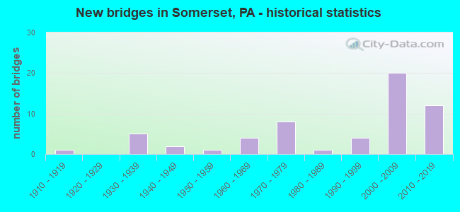
- New bridges - historical statistics
- 11910-1919
- 51930-1939
- 21940-1949
- 11950-1959
- 41960-1969
- 81970-1979
- 11980-1989
- 41990-1999
- 202000-2009
- 122010-2019
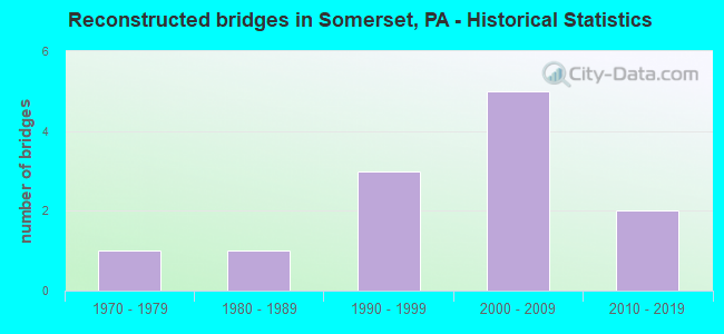
- Reconstructed bridges - Historical Statistics
- 11970-1979
- 11980-1989
- 31990-1999
- 52000-2009
- 22010-2019
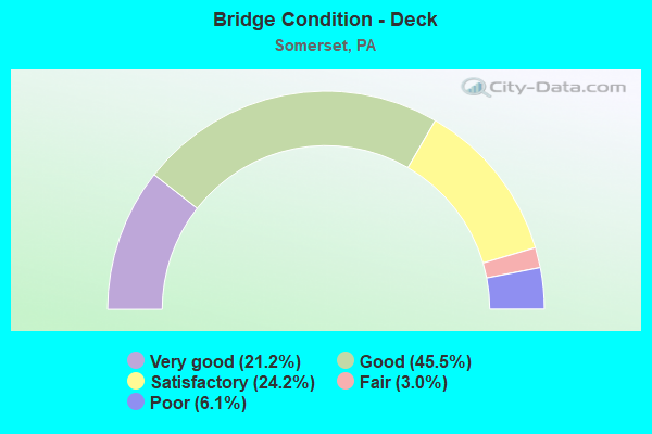
- Bridge Condition - Deck
- 21.2%Very good
- 45.5%Good
- 24.2%Satisfactory
- 3.0%Fair
- 6.1%Poor
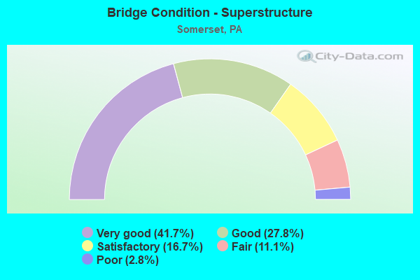
- Bridge Condition - Superstructure
- 41.7%Very good
- 27.8%Good
- 16.7%Satisfactory
- 11.1%Fair
- 2.8%Poor
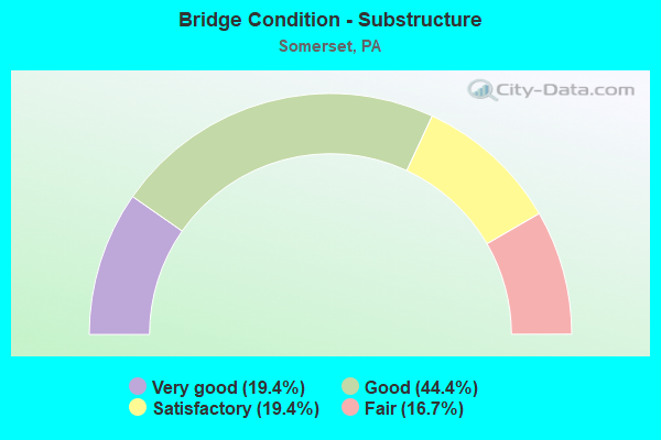
- Bridge Condition - Substructure
- 19.4%Very good
- 44.4%Good
- 19.4%Satisfactory
- 16.7%Fair
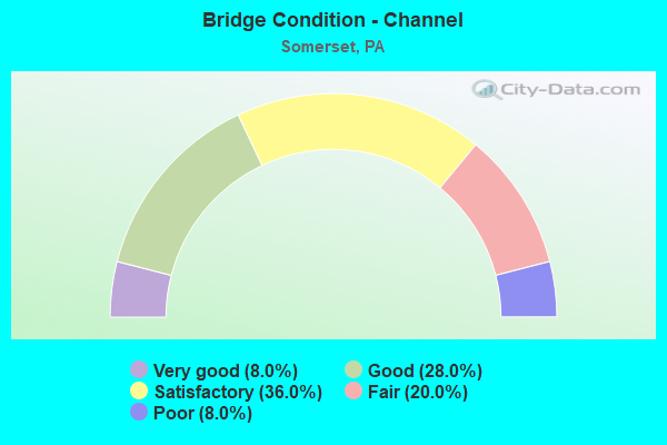
- Bridge Condition - Channel
- 8.0%Very good
- 28.0%Good
- 36.0%Satisfactory
- 20.0%Fair
- 8.0%Poor
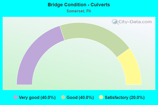
- Bridge Condition - Culverts
- 40.0%Very good
- 40.0%Good
- 20.0%Satisfactory
Find on map >> Show street view
Structure Number: 55702, Location: 1.4 MILE SOUTH OF US 30 (Lat: 39.963533, Lng: -79.044861), Route carried "on" structure: US 219, Year Built: 2018, Status: Open, Structure Length: 4.08m (13.39ft), Average Daily Traffic: 1,979 (year 2020), Truck Traffic: 11%, Average Future Daily Traffic: 366 (year 2038), Design Load: HL 93, Features Intersected: T-519 WALTERS MILL RD
Minimum Vertical Clearance: 30+ m (98+ ft), Kilometerpoint: 30.985, Lanes on structure: 2, Lanes under structure: 2, Base Highway Network: Yes, Owner: State Highway Agency, Approaching Roadway Width: 12.8m (42.0ft), Skew: 1 degrees, Material/Design: Prestressed concrete, Design/Construction: Stringer/Multi-beam, Number Of Spans In Main Unit: 1, Length of Maximum Span: 39.9m (130.9ft), Curb or Sidewalk Widths: Left: 0.2m (0.7ft), Right: 0.2m (0.7ft), Curb-To-Curb Width: 12.8m (42.0ft), Out-to-Out Width: 13.8m (45.3ft)
Condition: Deck: Very good, Superstructure: Very good, Substructure: Very good, Operating Rating: 55.1 metric tons, Method Used To Determine Operating Rating: Assigned ratings based on Load and Resistance Factor Design (LRFD) reported by rating factor (RF) using HL93 loadings, Inventory Rating: 39.2 metric tons, Method Used To Determine Inventory Rating: Assigned ratings based on Load and Resistance Factor Design (LRFD) reported by rating factor (RF) using HL93 loadings, Structural Evaluation: Equal to present desirable criteria, Deck Geometry: Equal to present desirable criteria, Underclear: Superior to present desirable criteria, Approach Roadway Alignment: Equal to present desirable criteria, Length Of Structure Improvement: 4.08m (13.39ft), Designated Inspection Frequency: Every 24 months, Inspection Date: May 2020, Deck Structure Type: Concrete Cast-file-Place, Wearing Surface/Protective System: Wearing Surface: Monolithic Concrete, Deck Protection: Galvanized Reinforcing
Find on map >> Show street view
Structure Number: 55707, Location: 5.2 MILE NW OF BERLIN (Lat: 39.934767, Lng: -79.048764), Route carried "on" structure: US 219, Year Built: 2018, Status: Open, Structure Length: 3.93m (12.89ft), Average Daily Traffic: 1,979 (year 2020), Truck Traffic: 11%, Average Future Daily Traffic: 366 (year 2038), Design Load: HL 93, Features Intersected: SR 3010
Minimum Vertical Clearance: 30+ m (98+ ft), Kilometerpoint: 27.761, Lanes on structure: 2, Lanes under structure: 2, Base Highway Network: Yes, Owner: State Highway Agency, Approaching Roadway Width: 12.8m (42.0ft), Material/Design: Prestressed concrete, Design/Construction: Stringer/Multi-beam, Number Of Spans In Main Unit: 1, Length of Maximum Span: 38.4m (126.0ft), Curb or Sidewalk Widths: Left: 0.2m (0.7ft), Right: 0.2m (0.7ft), Curb-To-Curb Width: 12.8m (42.0ft), Out-to-Out Width: 13.8m (45.3ft)
Condition: Deck: Very good, Superstructure: Very good, Substructure: Very good, Operating Rating: 55.4 metric tons, Method Used To Determine Operating Rating: Assigned ratings based on Load and Resistance Factor Design (LRFD) reported by rating factor (RF) using HL93 loadings, Inventory Rating: 41.1 metric tons, Method Used To Determine Inventory Rating: Assigned ratings based on Load and Resistance Factor Design (LRFD) reported by rating factor (RF) using HL93 loadings, Structural Evaluation: Equal to present desirable criteria, Deck Geometry: Equal to present desirable criteria, Underclear: Superior to present desirable criteria, Approach Roadway Alignment: Equal to present desirable criteria, Length Of Structure Improvement: 3.93m (12.89ft), Designated Inspection Frequency: Every 24 months, Inspection Date: June 2020, Deck Structure Type: Concrete Cast-file-Place, Wearing Surface/Protective System: Wearing Surface: Monolithic Concrete, Deck Protection: Galvanized Reinforcing
Find on map >> Show street view
Structure Number: 56992, Location: SOMERSET (Lat: 40.018333, Lng: -79.077500), Route carried "on" structure: State highway 601, Year Built: 2019, Status: Open, Structure Length: 6.95m (22.80ft), Average Daily Traffic: 13,824 (year 2020), Truck Traffic: 4%, Average Future Daily Traffic: 19,578 (year 2039), Design Load: HS 20, Features Intersected: PA TPK I-76
Minimum Vertical Clearance: 30+ m (98+ ft), Kilometerpoint: 0.946, Lanes on structure: 3, Lanes under structure: 7, Base Highway Network: Yes, Owner: State Toll Authority, Approaching Roadway Width: 16.5m (54.1ft), Skew: 3 degrees, Material/Design: Steel continuous, Design/Construction: Stringer/Multi-beam, Number Of Spans In Main Unit: 2, Length of Maximum Span: 36.0m (118.1ft), Curb-To-Curb Width: 16.5m (54.1ft), Out-to-Out Width: 17.2m (56.4ft)
Condition: Deck: Good, Superstructure: Very good, Substructure: Very good, Operating Rating: 88.0 metric tons, Method Used To Determine Operating Rating: Assigned ratings based on Load and Resistance Factor Design (LRFD) reported in metric tons, Inventory Rating: 68.1 metric tons, Method Used To Determine Inventory Rating: Assigned ratings based on Load and Resistance Factor Design (LRFD) reported in metric tons, Structural Evaluation: Equal to present desirable criteria, Deck Geometry: Better than present minimum criteria, Underclear: Equal to present minimum criteria, Approach Roadway Alignment: Better than present minimum criteria, Designated Inspection Frequency: Every 24 months, Inspection Date: July 2021, Deck Structure Type: Concrete Cast-file-Place, Wearing Surface/Protective System: Wearing Surface: Monolithic Concrete, Deck Protection: Epoxy Coated Reinforcing
Find on map >> Show street view
Structure Number: 31341, Location: .8 MI.E.OF SOMERSET (Lat: 40.001986, Lng: -79.036056), Route carried "under" structure: US 219, Year Built: 1973, Structure Length: 0. m, Average Daily Traffic: 2,306 (year 2022), Truck Traffic: 12%, Features Intersected: US 219, Facility Carried by Structure: PA 31
Minimum Vertical Clearance: 5.03m (16.50ft), Kilometerpoint: 35.398, Lanes on structure: 2, Lanes under structure: 4, Material/Design: Steel continuous, Design/Construction: Stringer/Multi-beam, Length of Maximum Span: 31.1m (102.0ft)
Find on map >> Show street view
Structure Number: 31341, Location: .8 MI.E.OF SOMERSET (Lat: 40.001986, Lng: -79.036056), Route carried "under" structure: US 219, Year Built: 1973, Structure Length: 0. m, Average Daily Traffic: 2,759 (year 2022), Truck Traffic: 9%, Features Intersected: US 219, Facility Carried by Structure: PA 31
Minimum Vertical Clearance: 5.03m (16.50ft), Kilometerpoint: 35.417, Lanes on structure: 2, Lanes under structure: 4, Material/Design: Steel continuous, Design/Construction: Stringer/Multi-beam, Length of Maximum Span: 31.1m (102.0ft)
Find on map >> Show street view
Structure Number: 31389, Location: BERLIN-SOMERSET INTERCHNG (Lat: 39.983083, Lng: -79.041461), Route carried "under" structure: US 219, Year Built: 1973, Structure Length: 0. m, Average Daily Traffic: 2,306 (year 2022), Truck Traffic: 12%, Features Intersected: US 219 (0520 & 0521), Facility Carried by Structure: SR 2047(0510&0511)
Minimum Vertical Clearance: 5.03m (16.50ft), Kilometerpoint: 33.252, Lanes on structure: 2, Lanes under structure: 2, Material/Design: Steel continuous, Design/Construction: Stringer/Multi-beam, Length of Maximum Span: 40.2m (131.9ft)
Find on map >> Show street view
Structure Number: 31389, Location: BERLIN-SOMERSET INTERCHNG (Lat: 39.983083, Lng: -79.041461), Route carried "under" structure: US 219, Year Built: 1973, Structure Length: 0. m, Average Daily Traffic: 2,759 (year 2022), Truck Traffic: 9%, Features Intersected: US 219 (0520 & 0521), Facility Carried by Structure: SR 2047(0510&0511)
Minimum Vertical Clearance: 5.28m (17.32ft), Kilometerpoint: 33.315, Lanes on structure: 2, Lanes under structure: 2, Material/Design: Steel continuous, Design/Construction: Stringer/Multi-beam, Length of Maximum Span: 40.2m (131.9ft)
Find on map >> Show street view
Structure Number: 31391, Location: OVER PA TURNPIKE (Lat: 39.997592, Lng: -79.038317), Route carried "under" structure: Interstate 76, Year Built: 1973, Structure Length: 0. m, Average Daily Traffic: 25 (year 1993), Features Intersected: PENNSYLVANIA TURNPIKE, Facility Carried by Structure: US 219 NBL
Minimum Vertical Clearance: 4.95m (16.24ft), Kilometerpoint: 0.000, Lanes on structure: 2, Lanes under structure: 4, Material/Design: Steel, Design/Construction: Stringer/Multi-beam, Length of Maximum Span: 36.9m (121.1ft)
Find on map >> Show street view
Structure Number: 31392, Location: OVER PA TURNPIKE (Lat: 39.997703, Lng: -79.038669), Route carried "under" structure: Interstate 76, Year Built: 1973, Structure Length: 0. m, Average Daily Traffic: 25 (year 1993), Features Intersected: PENNSYLVANIA TURNPIKE, Facility Carried by Structure: US 219 SBL
Minimum Vertical Clearance: 5.16m (16.93ft), Kilometerpoint: 0.000, Lanes on structure: 2, Lanes under structure: 4, Material/Design: Steel, Design/Construction: Stringer/Multi-beam, Length of Maximum Span: 36.9m (121.1ft)
Find on map >> Show street view
Structure Number: 31798, Location: SOMERSET INTERCHANGE (Lat: 40.020742, Lng: -79.082019), Route carried "under" structure: Interstate 76, Year Built: 2004, Structure Length: 0. m, Average Daily Traffic: 32,134 (year 1999), Truck Traffic: 36%, Features Intersected: PA TPK (I-76), Facility Carried by Structure: PA TPK RAMPS
Minimum Vertical Clearance: 5.25m (17.22ft), Kilometerpoint: 0.000, Lanes on structure: 2, Lanes under structure: 5, Toll: On toll road, Material/Design: Steel, Design/Construction: Stringer/Multi-beam, Length of Maximum Span: 41.8m (137.1ft)
Find on map >> Show street view
Structure Number: 31803, Location: EAST OF SOMERSET INTERCHG (Lat: 40.013283, Lng: -79.072258), Route carried "under" structure: State highway 281, Year Built: 1939, Structure Length: 0. m, Average Daily Traffic: 9,951 (year 2020), Truck Traffic: 8%, Features Intersected: SR 0281, Facility Carried by Structure: PA TPK (I-76)
Minimum Vertical Clearance: 4.47m (14.67ft), Kilometerpoint: 38.710, Lanes on structure: 4, Lanes under structure: 2, Material/Design: Prestressed concrete, Design/Construction: Box Beam or Girders - Single/Spread, Length of Maximum Span: 9.1m (29.9ft)
Find on map >> Show street view
Structure Number: 31808, Location: NEAR SOMERSET MAINT.SHED (Lat: 39.993103, Lng: -79.015053), Route carried "under" structure: City street , Year Built: 2004, Structure Length: 0. m, Average Daily Traffic: 200 (year 1992), Features Intersected: T-546; B-441, Facility Carried by Structure: PA TPK (I-76)
Minimum Vertical Clearance: 4.50m (14.76ft), Kilometerpoint: 0.000, Lanes on structure: 4, Lanes under structure: 2, Toll: On toll road, Material/Design: Steel, Design/Construction: Stringer/Multi-beam, Length of Maximum Span: 19.8m (65.0ft)
Find on map >> Show street view
Structure Number: 41215, Location: 0.1 MI.EAST OF SOMERSET (Lat: 40.003381, Lng: -79.051231), Route carried "under" structure: Interstate 76, Year Built: 2000, Structure Length: 0. m, Average Daily Traffic: 27,137 (year 1997), Truck Traffic: 34%, Features Intersected: PTC, B-438, MP 111.96, Facility Carried by Structure: PA 31 (LR 49)
Minimum Vertical Clearance: 4.27m (14.01ft), Kilometerpoint: 0.000, Lanes on structure: 2, Lanes under structure: 4, Material/Design: Steel, Design/Construction: Stringer/Multi-beam, Length of Maximum Span: 56.4m (185.0ft)
Find on map >> Show street view
Structure Number: 41384, Location: NEAR SR 31 & SR 1001 JCT (Lat: 39.992583, Lng: -79.006111), Route carried "under" structure: Interstate 76, Year Built: 2001, Structure Length: 0. m, Average Daily Traffic: 29,452 (year 1999), Truck Traffic: 36%, Features Intersected: PTC, B-481, MP 114.55, Facility Carried by Structure: PA 31 (LR 49)
Minimum Vertical Clearance: 5.00m (16.40ft), Kilometerpoint: 0.000, Lanes on structure: 2, Lanes under structure: 4, Material/Design: Steel continuous, Design/Construction: Stringer/Multi-beam, Length of Maximum Span: 49.7m (163.1ft)
Find on map >> Show street view
Structure Number: 42196, Location: OVER SR 8005 (Lat: 40.056742, Lng: -79.061219), Route carried "under" structure: Ramp State highway , Year Built: 2003, Structure Length: 0. m, Average Daily Traffic: 1,647 (year 2022), Truck Traffic: 8%, Features Intersected: SR 8005, RAMPS C & D, Facility Carried by Structure: US 219 SBL
Minimum Vertical Clearance: 4.72m (15.49ft), Kilometerpoint: 0.000, Lanes on structure: 2, Lanes under structure: 1, Material/Design: Steel, Design/Construction: Stringer/Multi-beam, Length of Maximum Span: 24.1m (79.1ft)
Find on map >> Show street view
Structure Number: 42196, Location: OVER SR 8005 (Lat: 40.056742, Lng: -79.061219), Route carried "under" structure: Ramp State highway , Year Built: 2003, Structure Length: 0. m, Average Daily Traffic: 989 (year 2022), Truck Traffic: 7%, Features Intersected: SR 8005, RAMPS C & D, Facility Carried by Structure: US 219 SBL
Minimum Vertical Clearance: 4.72m (15.49ft), Kilometerpoint: 0.000, Lanes on structure: 2, Lanes under structure: 1, Material/Design: Steel, Design/Construction: Stringer/Multi-beam, Length of Maximum Span: 24.1m (79.1ft)
Find on map >> Show street view
Structure Number: 42206, Location: OVR SR8005,3MI N SOMERSET (Lat: 40.056875, Lng: -79.060819), Route carried "under" structure: Ramp State highway , Year Built: 2003, Structure Length: 0. m, Average Daily Traffic: 1,647 (year 2022), Truck Traffic: 8%, Features Intersected: SR 8005, RAMPS C & D, Facility Carried by Structure: US 219 NBL
Minimum Vertical Clearance: 4.67m (15.32ft), Kilometerpoint: 0.000, Lanes on structure: 2, Lanes under structure: 1, Material/Design: Steel, Design/Construction: Stringer/Multi-beam, Length of Maximum Span: 25.0m (82.0ft)
Find on map >> Show street view
Structure Number: 42206, Location: OVR SR8005,3MI N SOMERSET (Lat: 40.056875, Lng: -79.060819), Route carried "under" structure: Ramp State highway , Year Built: 2003, Structure Length: 0. m, Average Daily Traffic: 989 (year 2022), Truck Traffic: 7%, Features Intersected: SR 8005, RAMPS C & D, Facility Carried by Structure: US 219 NBL
Minimum Vertical Clearance: 4.70m (15.42ft), Kilometerpoint: 0.000, Lanes on structure: 2, Lanes under structure: 1, Material/Design: Steel, Design/Construction: Stringer/Multi-beam, Length of Maximum Span: 25.0m (82.0ft)
Find on map >> Show street view
Structure Number: 55696, Location: 5.2 MILE NW OF BERLIN (Lat: 39.934767, Lng: -79.048542), Route carried "under" structure: State highway , Year Built: 2018, Structure Length: 0. m, Average Daily Traffic: 426 (year 2022), Truck Traffic: 13%, Features Intersected: SR 3010, Facility Carried by Structure: US 219
Minimum Vertical Clearance: 5.36m (17.59ft), Kilometerpoint: 17.941, Lanes on structure: 2, Lanes under structure: 2, Material/Design: Prestressed concrete, Design/Construction: Stringer/Multi-beam, Length of Maximum Span: 38.4m (126.0ft)
Find on map >> Show street view
Structure Number: 55707, Location: 5.2 MILE NW OF BERLIN (Lat: 39.934767, Lng: -79.048764), Route carried "under" structure: State highway , Year Built: 2018, Structure Length: 0. m, Average Daily Traffic: 426 (year 2022), Truck Traffic: 13%, Features Intersected: SR 3010, Facility Carried by Structure: US 219
Minimum Vertical Clearance: 5.61m (18.41ft), Kilometerpoint: 17.941, Lanes on structure: 2, Lanes under structure: 2, Material/Design: Prestressed concrete, Design/Construction: Stringer/Multi-beam, Length of Maximum Span: 38.4m (126.0ft)