Bridge Statistics for South Salt Lake, Utah (UT)
Condition, Traffic, Stress, Structural Evaluation, Project Costs
- National Bridge Inventory (NBI) Statistics
- 100Number of bridges
- 2,375ft / 724mTotal length
- $10,684,000Total costs
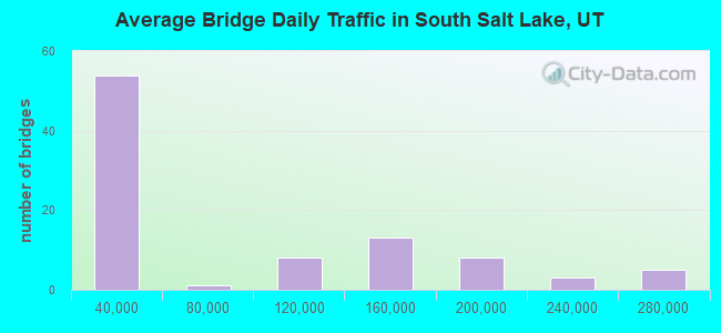
- 7,007,232Total average daily traffic
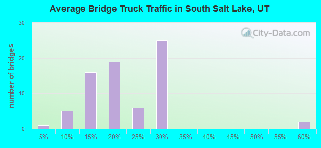
- 923,199Total average daily truck traffic
- National Bridge Inventory (NBI) Registered Bridges for South Salt Lake
- No street view available for this location
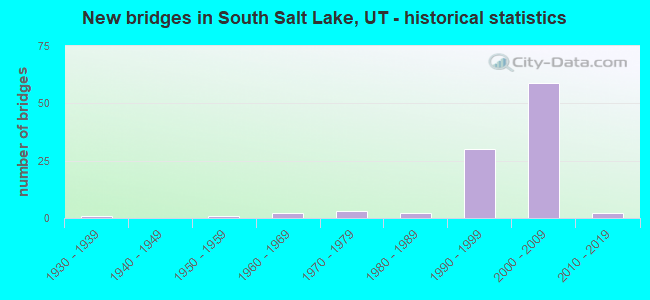
- New bridges - historical statistics
- 11930-1939
- 11950-1959
- 21960-1969
- 31970-1979
- 21980-1989
- 301990-1999
- 592000-2009
- 22010-2019
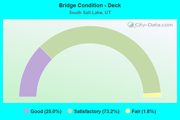
- Bridge Condition - Deck
- 25.0%Good
- 73.2%Satisfactory
- 1.8%Fair
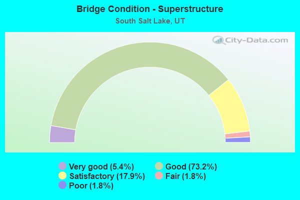
- Bridge Condition - Superstructure
- 5.4%Very good
- 73.2%Good
- 17.9%Satisfactory
- 1.8%Fair
- 1.8%Poor
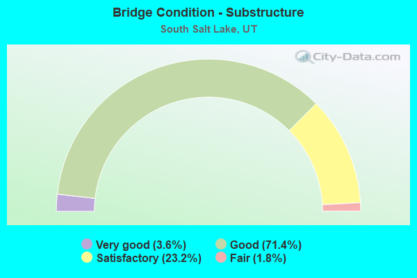
- Bridge Condition - Substructure
- 3.6%Very good
- 71.4%Good
- 23.2%Satisfactory
- 1.8%Fair
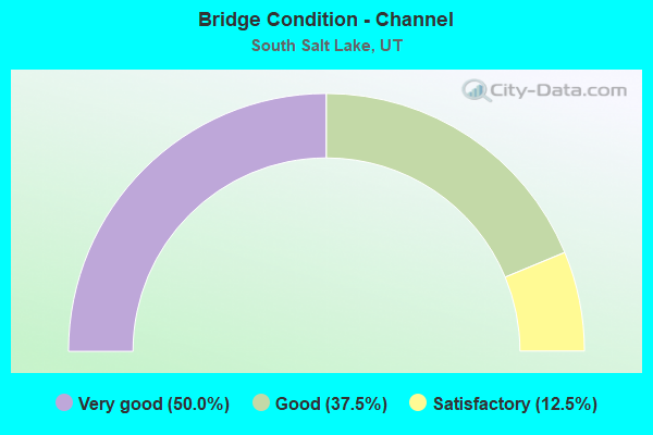
- Bridge Condition - Channel
- 50.0%Very good
- 37.5%Good
- 12.5%Satisfactory
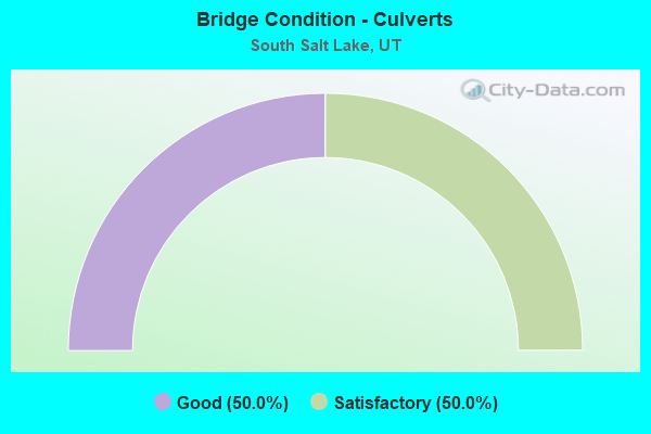
- Bridge Condition - Culverts
- 50.0%Good
- 50.0%Satisfactory
Find on map >> Show street view
Structure Number: 3F 653, Location: 350 W. 2250 SO., SO. SL. (Lat: 40.722714, Lng: -111.905300), Route carried "on" structure: Ramp Interstate 15, Year Built: 1999, Status: Open, Structure Length: 4.32m (14.17ft), Average Daily Traffic: 23,546 (year 2020), Truck Traffic: 25%, Average Future Daily Traffic: 29,433 (year 2040), Design Load: HS 25 or greater, Features Intersected: 2250 SOUTH ST. & UPR
Minimum Vertical Clearance: 5.62m (18.44ft), Kilometerpoint: 0.165, Lanes on structure: 1, Lanes under structure: 2, Owner: State Highway Agency, Approaching Roadway Width: 8.9m (29.2ft), Material/Design: Prestressed concrete, Design/Construction: Stringer/Multi-beam, Number Of Spans In Main Unit: 1, Length of Maximum Span: 42.3m (138.8ft), Curb-To-Curb Width: 8.4m (27.6ft), Out-to-Out Width: 9.3m (30.5ft)
Condition: Deck: Good, Superstructure: Good, Substructure: Good, Operating Rating: 48.6 metric tons, Method Used To Determine Operating Rating: Load and Resistance Factor Rating (LRFR) rating reported by rating factor(RF) method using HL-93 loadings, Inventory Rating: 43.7 metric tons, Method Used To Determine Inventory Rating: Load and Resistance Factor Rating (LRFR) rating reported by rating factor(RF) method using HL-93 loadings, Structural Evaluation: Better than present minimum criteria, Deck Geometry: Superior to present desirable criteria, Underclear: Meets minimum limits, Approach Roadway Alignment: Equal to present desirable criteria, Designated Inspection Frequency: Every 25 months, Inspection Date: June 2020, Deck Structure Type: Concrete Cast-file-Place, Wearing Surface/Protective System: Wearing Surface: Monolithic Concrete, Deck Protection: Epoxy Coated Reinforcing
Find on map >> Show street view
Structure Number: 3F 654, Location: 400 W. 2250 SO., SO. SL. (Lat: 40.722961, Lng: -111.905492), Route carried "on" structure: Ramp Interstate 15, Year Built: 1999, Status: Open, Structure Length: 6.89m (22.60ft), Average Daily Traffic: 23,546 (year 2020), Truck Traffic: 25%, Average Future Daily Traffic: 29,433 (year 2040), Design Load: HS 25 or greater, Features Intersected: UTA, LINE to WEST VALLEY
Minimum Vertical Clearance: 5.77m (18.93ft), Kilometerpoint: 0.674, Lanes on structure: 2, Owner: State Highway Agency, Approaching Roadway Width: 12.8m (42.0ft), Material/Design: Prestressed concrete continuous, Design/Construction: Stringer/Multi-beam, Number Of Spans In Main Unit: 2, Length of Maximum Span: 68.0m (223.1ft), Curb-To-Curb Width: 12.0m (39.4ft), Out-to-Out Width: 13.3m (43.6ft)
Condition: Deck: Satisfactory, Superstructure: Satisfactory, Substructure: Satisfactory, Operating Rating: 51.8 metric tons, Method Used To Determine Operating Rating: Load and Resistance Factor Rating (LRFR) rating reported by rating factor(RF) method using HL-93 loadings, Inventory Rating: 37.9 metric tons, Method Used To Determine Inventory Rating: Load Factor (LF) rating reported by rating factor (RF) method using MS18 loading, Structural Evaluation: Equal to present minimum criteria, Deck Geometry: Superior to present desirable criteria, Underclear: Meets minimum limits, Approach Roadway Alignment: Equal to present desirable criteria, Designated Inspection Frequency: Every 26 months, Inspection Date: May 2020, Deck Structure Type: Concrete Precast Panels, Wearing Surface/Protective System: Wearing Surface: Monolithic Concrete, Deck Protection: Epoxy Coated Reinforcing
Find on map >> Show street view
Structure Number: 3F 665, Location: 2400 SOUTH INTERCHANGE (Lat: 40.719022, Lng: -111.905867), Route carried "on" structure: Ramp Interstate 15, Year Built: 2000, Status: Open, Structure Length: 8.29m (27.20ft), Average Daily Traffic: 23,546 (year 2020), Truck Traffic: 25%, Average Future Daily Traffic: 29,433 (year 2040), Design Load: HS 25 or greater, Features Intersected: RAMP,I15SB DIST.to I15SB
Minimum Vertical Clearance: 30+ m (98+ ft), Kilometerpoint: 0.219, Lanes on structure: 1, Lanes under structure: 2, Owner: State Highway Agency, Approaching Roadway Width: 8.2m (26.9ft), Material/Design: Prestressed concrete continuous, Design/Construction: Stringer/Multi-beam, Number Of Spans In Main Unit: 3, Length of Maximum Span: 47.0m (154.2ft), Curb-To-Curb Width: 8.4m (27.6ft), Out-to-Out Width: 9.3m (30.5ft)
Condition: Deck: Satisfactory, Superstructure: Good, Substructure: Good, Operating Rating: 37.3 metric tons, Method Used To Determine Operating Rating: Load and Resistance Factor Rating (LRFR) rating reported by rating factor(RF) method using HL-93 loadings, Inventory Rating: 18.8 metric tons, Method Used To Determine Inventory Rating: Load Factor (LF) rating reported by rating factor (RF) method using MS18 loading, Structural Evaluation: Meets minimum limits, Deck Geometry: Superior to present desirable criteria, Underclear: Superior to present desirable criteria, Approach Roadway Alignment: Equal to present desirable criteria, Designated Inspection Frequency: Every 26 months, Inspection Date: May 2020, Deck Structure Type: Concrete Cast-file-Place, Wearing Surface/Protective System: Deck Protection: Epoxy Coated Reinforcing
Find on map >> Show street view
Structure Number: 4C 837, Location: 750 W. 2100 SO. ST.,SLC. (Lat: 40.724978, Lng: -111.911869), Route carried "on" structure: Ramp State highway 201, Year Built: 2000, Status: Open, Structure Length: 9.07m (29.76ft), Average Daily Traffic: 15,981 (year 2020), Truck Traffic: 19%, Average Future Daily Traffic: 19,976 (year 2040), Design Load: HS 25 or greater, Features Intersected: SR201WB OFF-RAMPto 900 W
Minimum Vertical Clearance: 30+ m (98+ ft), Kilometerpoint: 0.087, Lanes on structure: 2, Lanes under structure: 1, Owner: State Highway Agency, Approaching Roadway Width: 11.2m (36.7ft), Skew: 4 degrees, Material/Design: Steel continuous, Design/Construction: Stringer/Multi-beam, Number Of Spans In Main Unit: 3, Length of Maximum Span: 47.3m (155.2ft), Curb-To-Curb Width: 13.0m (42.7ft), Out-to-Out Width: 13.0m (42.7ft)
Condition: Deck: Satisfactory, Superstructure: Good, Substructure: Good, Operating Rating: 44.1 metric tons, Method Used To Determine Operating Rating: Load and Resistance Factor Rating (LRFR) rating reported by rating factor(RF) method using HL-93 loadings, Inventory Rating: 40.8 metric tons, Method Used To Determine Inventory Rating: Load Factor (LF) rating reported by rating factor (RF) method using MS18 loading, Structural Evaluation: Better than present minimum criteria, Deck Geometry: Superior to present desirable criteria, Underclear: Equal to present minimum criteria, Approach Roadway Alignment: Equal to present desirable criteria, Designated Inspection Frequency: Every 24 months, Inspection Date: December 2020, Deck Structure Type: Concrete Cast-file-Place, Wearing Surface/Protective System: Wearing Surface: Epoxy Overlay, Deck Protection: Epoxy Coated Reinforcing
Find on map >> Show street view
Structure Number: 4C 841, Location: I15,I80,SR201 INT.@2400 S (Lat: 40.724086, Lng: -111.906500), Route carried "on" structure: Ramp State highway 15, Year Built: 2000, Status: Open, Structure Length: 27.97m (91.77ft), Average Daily Traffic: 23,546 (year 2020), Truck Traffic: 25%, Average Future Daily Traffic: 29,433 (year 2040), Design Load: HS 25 or greater, Features Intersected: 700 WEST ST. & UPRR
Minimum Vertical Clearance: 5.23m (17.16ft), Kilometerpoint: 0.537, Lanes on structure: 3, Lanes under structure: 4, Base Highway Network: Yes (Inventory Route: 15PR3, Subroute: 2), Owner: State Highway Agency, Approaching Roadway Width: 23.8m (78.1ft), Skew: 9 degrees, Material/Design: Steel continuous, Design/Construction: Stringer/Multi-beam, Number Of Spans In Main Unit: 6, Length of Maximum Span: 71.3m (233.9ft), Curb-To-Curb Width: 16.2m (53.1ft), Out-to-Out Width: 20.0m (65.6ft)
Condition: Deck: Satisfactory, Superstructure: Good, Substructure: Satisfactory, Operating Rating: 32.4 metric tons, Method Used To Determine Operating Rating: Load and Resistance Factor Rating (LRFR) rating reported by rating factor(RF) method using HL-93 loadings, Inventory Rating: 25.3 metric tons, Method Used To Determine Inventory Rating: Load and Resistance Factor Rating (LRFR) rating reported by rating factor(RF) method using HL-93 loadings, Structural Evaluation: Equal to present minimum criteria, Deck Geometry: Superior to present desirable criteria, Underclear: Somewhat better than minimum adequacy, Approach Roadway Alignment: Equal to present desirable criteria, Length Of Structure Improvement: 24.80m (81.36ft), Designated Inspection Frequency: Every 25 months, Underwater Inspection Frequency: Every 60 months, Inspection Date: June 2020, Underwater Inspection Date: August 2019, Bridge Improvement Cost: $3,996,000, Roadway Improvement Cost: $400,000, Total Project Cost: $6,594,000, Deck Structure Type: Concrete Cast-file-Place, Wearing Surface/Protective System: Wearing Surface: Epoxy Overlay, Deck Protection: Epoxy Coated Reinforcing
Find on map >> Show street view
Structure Number: 4C 846, Location: I15,I80,SR201 INT.@2400 S (Lat: 40.718686, Lng: -111.902456), Route carried "on" structure: Ramp Interstate 15, Year Built: 2000, Status: Open, Structure Length: 72.27m (237.11ft), Average Daily Traffic: 23,546 (year 2020), Truck Traffic: 25%, Average Future Daily Traffic: 29,433 (year 2040), Design Load: HS 25 or greater, Features Intersected: I-15 & I15 COL-DIST.RPS., Facility Carried by Structure: RP.I80WB to SR201W
Minimum Vertical Clearance: 5.49m (18.01ft), Kilometerpoint: 0.114, Lanes on structure: 2, Lanes under structure: 19, Owner: State Highway Agency, Approaching Roadway Width: 11.8m (38.7ft), Skew: 9 degrees, Material/Design: Steel continuous, Design/Construction: Stringer/Multi-beam, Number Of Spans In Main Unit: 13, Length of Maximum Span: 91.0m (298.6ft), Curb-To-Curb Width: 12.0m (39.4ft), Out-to-Out Width: 12.9m (42.3ft)
Condition: Deck: Satisfactory, Superstructure: Good, Substructure: Good, Operating Rating: 76.5 metric tons, Method Used To Determine Operating Rating: Load and Resistance Factor Rating (LRFR) rating reported by rating factor(RF) method using HL-93 loadings, Inventory Rating: 43.4 metric tons, Method Used To Determine Inventory Rating: Load and Resistance Factor Rating (LRFR) rating reported by rating factor(RF) method using HL-93 loadings, Structural Evaluation: Better than present minimum criteria, Deck Geometry: Superior to present desirable criteria, Underclear: Equal to present minimum criteria, Approach Roadway Alignment: Equal to present desirable criteria, Designated Inspection Frequency: Every 25 months, Underwater Inspection Frequency: Every 60 months, Inspection Date: June 2020, Underwater Inspection Date: August 2019, Deck Structure Type: Concrete Cast-file-Place, Wearing Surface/Protective System: Wearing Surface: Latex Concrete, Deck Protection: Epoxy Coated Reinforcing
Find on map >> Show street view
Structure Number: 4C 847, Location: I15,I80,SR201 INT.@2400 S (Lat: 40.718531, Lng: -111.902461), Route carried "on" structure: Ramp Interstate 15, Year Built: 2000, Status: Open, Structure Length: 32.86m (107.81ft), Average Daily Traffic: 23,546 (year 2020), Truck Traffic: 25%, Average Future Daily Traffic: 29,433 (year 2040), Design Load: HS 25 or greater, Features Intersected: I-15 (SR-15) & CD.RP
Minimum Vertical Clearance: 30+ m (98+ ft), Kilometerpoint: 1.184, Lanes on structure: 2, Lanes under structure: 12, Owner: State Highway Agency, Approaching Roadway Width: 11.8m (38.7ft), Skew: 9 degrees, Material/Design: Steel continuous, Design/Construction: Stringer/Multi-beam, Number Of Spans In Main Unit: 6, Length of Maximum Span: 67.0m (219.8ft), Curb-To-Curb Width: 12.0m (39.4ft), Out-to-Out Width: 13.4m (44.0ft)
Condition: Deck: Satisfactory, Superstructure: Good, Substructure: Satisfactory, Operating Rating: 48.9 metric tons, Method Used To Determine Operating Rating: Load and Resistance Factor Rating (LRFR) rating reported by rating factor(RF) method using HL-93 loadings, Inventory Rating: 28.2 metric tons, Method Used To Determine Inventory Rating: Load and Resistance Factor Rating (LRFR) rating reported by rating factor(RF) method using HL-93 loadings, Structural Evaluation: Equal to present minimum criteria, Deck Geometry: Superior to present desirable criteria, Underclear: Equal to present minimum criteria, Approach Roadway Alignment: Equal to present desirable criteria, Designated Inspection Frequency: Every 24 months, Underwater Inspection Frequency: Every 60 months, Inspection Date: August 2020, Underwater Inspection Date: August 2019, Deck Structure Type: Concrete Cast-file-Place, Wearing Surface/Protective System: Wearing Surface: Epoxy Overlay, Deck Protection: Epoxy Coated Reinforcing
Find on map >> Show street view
Structure Number: 4C 848, Location: I15,I80,SR201 INT.@2400 S (Lat: 40.718572, Lng: -111.900517), Route carried "on" structure: Ramp Interstate 15, Year Built: 2000, Status: Open, Structure Length: 16.21m (53.18ft), Average Daily Traffic: 23,546 (year 2020), Truck Traffic: 25%, Average Future Daily Traffic: 29,433 (year 2040), Design Load: HS 25 or greater, Features Intersected: RP.I80WB toI15NB &NB RPS
Minimum Vertical Clearance: 5.49m (18.01ft), Kilometerpoint: 1.020, Lanes on structure: 3, Lanes under structure: 4, Base Highway Network: Yes (Inventory Route: 15NR3, Subroute: 4), Owner: State Highway Agency, Approaching Roadway Width: 18.2m (59.7ft), Material/Design: Steel continuous, Design/Construction: Stringer/Multi-beam, Number Of Spans In Main Unit: 4, Length of Maximum Span: 53.9m (176.8ft), Curb-To-Curb Width: 17.5m (57.4ft), Out-to-Out Width: 28.3m (92.8ft)
Condition: Deck: Satisfactory, Superstructure: Good, Substructure: Satisfactory, Operating Rating: 41.1 metric tons, Method Used To Determine Operating Rating: Load and Resistance Factor Rating (LRFR) rating reported by rating factor(RF) method using HL-93 loadings, Inventory Rating: 27.2 metric tons, Method Used To Determine Inventory Rating: Load and Resistance Factor Rating (LRFR) rating reported by rating factor(RF) method using HL-93 loadings, Structural Evaluation: Equal to present minimum criteria, Deck Geometry: Superior to present desirable criteria, Underclear: Superior to present desirable criteria, Approach Roadway Alignment: Equal to present desirable criteria, Designated Inspection Frequency: Every 24 months, Inspection Date: June 2020, Deck Structure Type: Concrete Cast-file-Place, Wearing Surface/Protective System: Wearing Surface: Monolithic Concrete, Deck Protection: Epoxy Coated Reinforcing
Find on map >> Show street view
Structure Number: 4C 851, Location: I15,180,SR201 INT.@2400 S (Lat: 40.718381, Lng: -111.899208), Route carried "on" structure: Ramp Interstate 15, Year Built: 2000, Status: Open, Structure Length: 28.35m (93.01ft), Average Daily Traffic: 23,546 (year 2020), Truck Traffic: 25%, Average Future Daily Traffic: 29,433 (year 2040), Design Load: HS 25 or greater, Features Intersected: STORM DRN.RETENTION POND
Minimum Vertical Clearance: 6.50m (21.33ft), Kilometerpoint: 0.094, Lanes on structure: 1, Owner: State Highway Agency, Approaching Roadway Width: 8.1m (26.6ft), Skew: 9 degrees, Material/Design: Steel continuous, Design/Construction: Stringer/Multi-beam, Number Of Spans In Main Unit: 7, Length of Maximum Span: 45.0m (147.6ft), Curb-To-Curb Width: 8.4m (27.6ft), Out-to-Out Width: 9.3m (30.5ft)
Condition: Deck: Good, Superstructure: Good, Substructure: Good, Channel: Very good, Operating Rating: 60.6 metric tons, Method Used To Determine Operating Rating: Load and Resistance Factor Rating (LRFR) rating reported by rating factor(RF) method using HL-93 loadings, Inventory Rating: 35.6 metric tons, Method Used To Determine Inventory Rating: Load and Resistance Factor Rating (LRFR) rating reported by rating factor(RF) method using HL-93 loadings, Structural Evaluation: Better than present minimum criteria, Deck Geometry: Superior to present desirable criteria, Waterway Adequacy: Equal to present desirable criteria, Approach Roadway Alignment: Equal to present desirable criteria, Designated Inspection Frequency: Every 24 months, Underwater Inspection Frequency: Every 60 months, Inspection Date: June 2020, Underwater Inspection Date: August 2019, Deck Structure Type: Concrete Cast-file-Place, Wearing Surface/Protective System: Wearing Surface: Epoxy Overlay, Deck Protection: Epoxy Coated Reinforcing
Find on map >> Show street view
Structure Number: 4C 852, Location: I15,I80,SR201 INT.@2400 S (Lat: 40.718686, Lng: -111.900536), Route carried "on" structure: Ramp Interstate 15, Year Built: 1999, Status: Open, Structure Length: 43.82m (143.77ft), Average Daily Traffic: 23,546 (year 2020), Truck Traffic: 25%, Average Future Daily Traffic: 29,433 (year 2040), Design Load: HS 25 or greater, Features Intersected: STORM DRN.RETENTION POND
Minimum Vertical Clearance: 30.18m (99.02ft), Kilometerpoint: 0.244, Lanes on structure: 1, Owner: State Highway Agency, Approaching Roadway Width: 8.1m (26.6ft), Skew: 9 degrees, Material/Design: Steel continuous, Design/Construction: Stringer/Multi-beam, Number Of Spans In Main Unit: 13, Length of Maximum Span: 35.0m (114.8ft), Curb-To-Curb Width: 8.4m (27.6ft), Out-to-Out Width: 9.3m (30.5ft)
Condition: Deck: Satisfactory, Superstructure: Good, Substructure: Good, Operating Rating: 92.3 metric tons, Method Used To Determine Operating Rating: Load and Resistance Factor Rating (LRFR) rating reported by rating factor(RF) method using HL-93 loadings, Inventory Rating: 52.5 metric tons, Method Used To Determine Inventory Rating: Load and Resistance Factor Rating (LRFR) rating reported by rating factor(RF) method using HL-93 loadings, Structural Evaluation: Better than present minimum criteria, Deck Geometry: Superior to present desirable criteria, Approach Roadway Alignment: Equal to present desirable criteria, Designated Inspection Frequency: Every 24 months, Underwater Inspection Frequency: Every 60 months, Inspection Date: June 2020, Underwater Inspection Date: August 2019, Deck Structure Type: Concrete Cast-file-Place, Wearing Surface/Protective System: Wearing Surface: Epoxy Overlay, Deck Protection: Epoxy Coated Reinforcing
Find on map >> Show street view
Structure Number: 4C 853, Location: I80-I15 INTCHG.@ 240 (Lat: 40.718283, Lng: -111.899203), Route carried "on" structure: Ramp Interstate 80, Year Built: 1999, Status: Open, Structure Length: 10.05m (32.97ft), Average Daily Traffic: 129,858 (year 2020), Truck Traffic: 15%, Average Future Daily Traffic: 162,323 (year 2040), Design Load: HS 25 or greater, Features Intersected: 300 W.ST.IN SO.SALT LAKE
Minimum Vertical Clearance: 30.18m (99.02ft), Kilometerpoint: 197.792, Lanes on structure: 4, Lanes under structure: 5, Owner: State Highway Agency, Approaching Roadway Width: 28.4m (93.2ft), Skew: 10 degrees, Material/Design: Steel continuous, Design/Construction: Stringer/Multi-beam, Number Of Spans In Main Unit: 2, Length of Maximum Span: 50.0m (164.0ft), Curb-To-Curb Width: 28.7m (94.2ft), Out-to-Out Width: 29.3m (96.1ft)
Condition: Deck: Satisfactory, Superstructure: Good, Substructure: Good, Operating Rating: 51.2 metric tons, Method Used To Determine Operating Rating: Load and Resistance Factor Rating (LRFR) rating reported by rating factor(RF) method using HL-93 loadings, Inventory Rating: 50.5 metric tons, Method Used To Determine Inventory Rating: Load Factor (LF) rating reported by rating factor (RF) method using MS18 loading, Structural Evaluation: Better than present minimum criteria, Deck Geometry: Superior to present desirable criteria, Underclear: Meets minimum limits, Approach Roadway Alignment: Equal to present desirable criteria, Designated Inspection Frequency: Every 25 months, Inspection Date: June 2020, Deck Structure Type: Concrete Cast-file-Place, Wearing Surface/Protective System: Wearing Surface: Epoxy Overlay, Deck Protection: Epoxy Coated Reinforcing
Find on map >> Show street view
Structure Number: 4C 855, Location: 2400 SO. 200 WEST, SO.SL. (Lat: 40.718317, Lng: -111.896447), Route carried "on" structure: Interstate 80, Year Built: 1999, Status: Open, Structure Length: 4.32m (14.17ft), Average Daily Traffic: 129,858 (year 2020), Truck Traffic: 15%, Average Future Daily Traffic: 162,323 (year 2040), Design Load: HS 25 or greater, Features Intersected: UTA LIGHT RAIL TRACKS
Minimum Vertical Clearance: 30+ m (98+ ft), Kilometerpoint: 198.025, Lanes on structure: 3, Base Highway Network: Yes, Owner: State Highway Agency, Approaching Roadway Width: 16.5m (54.1ft), Skew: 30 degrees, Material/Design: Steel, Design/Construction: Stringer/Multi-beam, Number Of Spans In Main Unit: 1, Length of Maximum Span: 42.3m (138.8ft), Curb-To-Curb Width: 16.8m (55.1ft), Out-to-Out Width: 17.7m (58.1ft)
Condition: Deck: Satisfactory, Superstructure: Good, Substructure: Good, Operating Rating: 67.7 metric tons, Method Used To Determine Operating Rating: Load and Resistance Factor Rating (LRFR) rating reported by rating factor(RF) method using HL-93 loadings, Inventory Rating: 58.0 metric tons, Method Used To Determine Inventory Rating: Load Factor (LF) rating reported by rating factor (RF) method using MS18 loading, Structural Evaluation: Better than present minimum criteria, Deck Geometry: Equal to present minimum criteria, Underclear: Superior to present desirable criteria, Approach Roadway Alignment: Equal to present desirable criteria, Designated Inspection Frequency: Every 25 months, Inspection Date: June 2020, Deck Structure Type: Concrete Cast-file-Place, Wearing Surface/Protective System: Wearing Surface: Monolithic Concrete, Deck Protection: Epoxy Coated Reinforcing
Find on map >> Show street view
Structure Number: 4C 856, Location: 2400 SO. 200 WEST, SO.SL. (Lat: 40.718492, Lng: -111.896436), Route carried "on" structure: Alternate Interstate 15, Year Built: 1999, Status: Open, Structure Length: 4.32m (14.17ft), Average Daily Traffic: 23,546 (year 2020), Truck Traffic: 25%, Average Future Daily Traffic: 29,433 (year 2040), Design Load: HS 25 or greater, Features Intersected: UTA LIGHT RAIL TRACKS, Facility Carried by Structure: I-80 WB COL-DIST.
Minimum Vertical Clearance: 30+ m (98+ ft), Kilometerpoint: 0.675, Lanes on structure: 3, Owner: State Highway Agency, Approaching Roadway Width: 16.5m (54.1ft), Skew: 10 degrees, Material/Design: Steel, Design/Construction: Stringer/Multi-beam, Number Of Spans In Main Unit: 1, Length of Maximum Span: 42.3m (138.8ft), Curb-To-Curb Width: 16.8m (55.1ft), Out-to-Out Width: 17.7m (58.1ft)
Condition: Deck: Satisfactory, Superstructure: Good, Substructure: Good, Operating Rating: 68.7 metric tons, Method Used To Determine Operating Rating: Load and Resistance Factor Rating (LRFR) rating reported by rating factor(RF) method using HL-93 loadings, Inventory Rating: 58.6 metric tons, Method Used To Determine Inventory Rating: Load Factor (LF) rating reported by rating factor (RF) method using MS18 loading, Structural Evaluation: Better than present minimum criteria, Deck Geometry: Equal to present minimum criteria, Underclear: Superior to present desirable criteria, Approach Roadway Alignment: Equal to present desirable criteria, Designated Inspection Frequency: Every 24 months, Inspection Date: June 2020, Deck Structure Type: Concrete Cast-file-Place, Wearing Surface/Protective System: Deck Protection: Epoxy Coated Reinforcing
Find on map >> Show street view
Structure Number: 4C 956, Location: 2400 So.300 E. in So.SL (Lat: 40.718356, Lng: -111.882267), Route carried "on" structure: Interstate 80, Year Built: 2008, Status: Open, Structure Length: 3.41m (11.19ft), Average Daily Traffic: 117,829 (year 2020), Truck Traffic: 15%, Average Future Daily Traffic: 147,286 (year 2040), Design Load: HL 93, Features Intersected: 300 EAST STREET in So.SL
Minimum Vertical Clearance: 30+ m (98+ ft), Kilometerpoint: 199.222, Lanes on structure: 5, Lanes under structure: 2, Base Highway Network: Yes, Owner: State Highway Agency, Approaching Roadway Width: 24.4m (80.1ft), Skew: 30 degrees, Material/Design: Steel, Design/Construction: Stringer/Multi-beam, Number Of Spans In Main Unit: 1, Length of Maximum Span: 32.9m (107.9ft), Curb-To-Curb Width: 25.6m (84.0ft), Out-to-Out Width: 26.5m (86.9ft)
Condition: Deck: Satisfactory, Superstructure: Good, Substructure: Good, Operating Rating: 79.7 metric tons, Method Used To Determine Operating Rating: Load and Resistance Factor Rating (LRFR) rating reported by rating factor(RF) method using HL-93 loadings, Inventory Rating: 61.6 metric tons, Method Used To Determine Inventory Rating: Load and Resistance Factor Rating (LRFR) rating reported by rating factor(RF) method using HL-93 loadings, Structural Evaluation: Better than present minimum criteria, Deck Geometry: Better than present minimum criteria, Underclear: Equal to present minimum criteria, Approach Roadway Alignment: Equal to present desirable criteria, Designated Inspection Frequency: Every 25 months, Inspection Date: June 2020, Deck Structure Type: Concrete Cast-file-Place, Wearing Surface/Protective System: Wearing Surface: Epoxy Overlay, Deck Protection: Epoxy Coated Reinforcing
Find on map >> Show street view
Structure Number: 4F 620W, Location: WEST OF 900 WEST INTCHG. (Lat: 40.724456, Lng: -111.923606), Route carried "on" structure: State highway 201, Year Built: 2000, Status: Open, Structure Length: 7.78m (25.52ft), Average Daily Traffic: 94,191 (year 2020), Truck Traffic: 20%, Average Future Daily Traffic: 117,739 (year 2040), Design Load: HS 25 or greater, Features Intersected: JORDAN RIVER
Minimum Vertical Clearance: 30+ m (98+ ft), Kilometerpoint: 26.003, Lanes on structure: 5, Base Highway Network: Yes, Owner: State Highway Agency, Approaching Roadway Width: 24.1m (79.1ft), Skew: 4 degrees, Material/Design: Prestressed concrete continuous, Design/Construction: Stringer/Multi-beam, Number Of Spans In Main Unit: 2, Number Of Approach Spans: 1, Length of Maximum Span: 42.7m (140.1ft), Curb-To-Curb Width: 24.4m (80.1ft), Out-to-Out Width: 25.3m (83.0ft)
Condition: Deck: Satisfactory, Superstructure: Satisfactory, Substructure: Good, Channel: Very good, Operating Rating: 46.7 metric tons, Method Used To Determine Operating Rating: Load and Resistance Factor Rating (LRFR) rating reported by rating factor(RF) method using HL-93 loadings, Inventory Rating: 40.8 metric tons, Method Used To Determine Inventory Rating: Load Factor (LF) rating reported by rating factor (RF) method using MS18 loading, Structural Evaluation: Equal to present minimum criteria, Deck Geometry: Equal to present minimum criteria, Waterway Adequacy: Equal to present desirable criteria, Approach Roadway Alignment: Equal to present desirable criteria, Designated Inspection Frequency: Every 24 months, Inspection Date: December 2020, Deck Structure Type: Concrete Cast-file-Place, Wearing Surface/Protective System: Wearing Surface: Latex Concrete, Deck Protection: Epoxy Coated Reinforcing
Find on map >> Show street view
Structure Number: 4F 621W, Location: 215O SOUTH 900 WEST, SLC. (Lat: 40.724208, Lng: -111.916625), Route carried "on" structure: State highway 201, Year Built: 2000, Status: Open, Structure Length: 7.10m (23.29ft), Average Daily Traffic: 94,191 (year 2020), Truck Traffic: 20%, Average Future Daily Traffic: 117,739 (year 2040), Design Load: HS 25 or greater, Features Intersected: 900 WEST ST.,INTCHG.X-RD
Minimum Vertical Clearance: 30+ m (98+ ft), Kilometerpoint: 26.593, Lanes on structure: 4, Lanes under structure: 6, Base Highway Network: Yes, Owner: State Highway Agency, Approaching Roadway Width: 25.7m (84.3ft), Skew: 1 degrees, Material/Design: Prestressed concrete, Design/Construction: Stringer/Multi-beam, Number Of Spans In Main Unit: 1, Length of Maximum Span: 67.5m (221.5ft), Curb-To-Curb Width: 22.1m (72.5ft), Out-to-Out Width: 24.9m (81.7ft)
Condition: Deck: Good, Superstructure: Satisfactory, Substructure: Very good, Operating Rating: 52.8 metric tons, Method Used To Determine Operating Rating: Load and Resistance Factor Rating (LRFR) rating reported by rating factor(RF) method using HL-93 loadings, Inventory Rating: 37.6 metric tons, Method Used To Determine Inventory Rating: Load and Resistance Factor Rating (LRFR) rating reported by rating factor(RF) method using HL-93 loadings, Structural Evaluation: Equal to present minimum criteria, Deck Geometry: Equal to present desirable criteria, Underclear: Meets minimum limits, Approach Roadway Alignment: Equal to present desirable criteria, Designated Inspection Frequency: Every 24 months, Inspection Date: December 2020, Deck Structure Type: Concrete Cast-file-Place, Wearing Surface/Protective System: Wearing Surface: Epoxy Overlay, Deck Protection: Epoxy Coated Reinforcing
Find on map >> Show street view
Structure Number: 4F 623, Location: 2400 SO.300 WEST, SO.SL. (Lat: 40.718550, Lng: -111.899133), Route carried "on" structure: Interstate 15, Year Built: 1999, Status: Open, Structure Length: 4.59m (15.06ft), Average Daily Traffic: 23,546 (year 2020), Truck Traffic: 25%, Average Future Daily Traffic: 29,433 (year 2040), Design Load: HS 25 or greater, Features Intersected: 300 WEST STREET, Facility Carried by Structure: I-80 (SR-80) WBL
Minimum Vertical Clearance: 30+ m (98+ ft), Kilometerpoint: 0.903, Lanes on structure: 4, Lanes under structure: 4, Base Highway Network: Yes (Inventory Route: 15NR3, Subroute: 4), Owner: State Highway Agency, Approaching Roadway Width: 23.6m (77.4ft), Skew: 30 degrees, Material/Design: Prestressed concrete, Design/Construction: Stringer/Multi-beam, Number Of Spans In Main Unit: 1, Length of Maximum Span: 45.0m (147.6ft), Curb-To-Curb Width: 23.9m (78.4ft), Out-to-Out Width: 25.9m (85.0ft)
Condition: Deck: Satisfactory, Superstructure: Good, Substructure: Good, Operating Rating: 48.9 metric tons, Method Used To Determine Operating Rating: Load and Resistance Factor Rating (LRFR) rating reported by rating factor(RF) method using HL-93 loadings, Inventory Rating: 43.1 metric tons, Method Used To Determine Inventory Rating: Load and Resistance Factor Rating (LRFR) rating reported by rating factor(RF) method using HL-93 loadings, Structural Evaluation: Better than present minimum criteria, Deck Geometry: Superior to present desirable criteria, Underclear: Equal to present minimum criteria, Approach Roadway Alignment: Equal to present desirable criteria, Designated Inspection Frequency: Every 25 months, Inspection Date: June 2020, Deck Structure Type: Concrete Cast-file-Place, Wearing Surface/Protective System: Wearing Surface: Latex Concrete, Deck Protection: Epoxy Coated Reinforcing
Find on map >> Show street view
Structure Number: 4F 626W, Location: 2400 SO. MAIN in SO.SL. (Lat: 40.718331, Lng: -111.890675), Route carried "on" structure: Interstate 80, Year Built: 1999, Status: Open, Structure Length: 4.54m (14.90ft), Average Daily Traffic: 129,858 (year 2020), Truck Traffic: 15%, Average Future Daily Traffic: 162,323 (year 2040), Design Load: HS 25 or greater, Features Intersected: MAIN STREET
Minimum Vertical Clearance: 30+ m (98+ ft), Kilometerpoint: 198.512, Lanes on structure: 6, Lanes under structure: 4, Base Highway Network: Yes, Owner: State Highway Agency, Approaching Roadway Width: 36.7m (120.4ft), Skew: 30 degrees, Material/Design: Prestressed concrete continuous, Design/Construction: Stringer/Multi-beam, Number Of Spans In Main Unit: 3, Length of Maximum Span: 25.1m (82.3ft), Curb-To-Curb Width: 37.0m (121.4ft), Out-to-Out Width: 37.3m (122.4ft)
Condition: Deck: Satisfactory, Superstructure: Good, Substructure: Satisfactory, Operating Rating: 64.5 metric tons, Method Used To Determine Operating Rating: Load and Resistance Factor Rating (LRFR) rating reported by rating factor(RF) method using HL-93 loadings, Inventory Rating: 24.6 metric tons, Method Used To Determine Inventory Rating: Load Factor (LF) rating reported by rating factor (RF) method using MS18 loading, Structural Evaluation: Equal to present minimum criteria, Deck Geometry: Superior to present desirable criteria, Underclear: Somewhat better than minimum adequacy, Approach Roadway Alignment: Equal to present desirable criteria, Designated Inspection Frequency: Every 25 months, Inspection Date: June 2020, Deck Structure Type: Concrete Cast-file-Place, Wearing Surface/Protective System: Wearing Surface: Latex Concrete, Deck Protection: Epoxy Coated Reinforcing
Find on map >> Show street view
Structure Number: 4F 651W, Location: 2400 SOUTH WEST TEMPLE (Lat: 40.718328, Lng: -111.893589), Route carried "on" structure: Interstate 80, Year Built: 1999, Status: Open, Structure Length: 3.59m (11.78ft), Average Daily Traffic: 129,858 (year 2020), Truck Traffic: 15%, Average Future Daily Traffic: 162,323 (year 2040), Design Load: HS 25 or greater, Features Intersected: WEST TEMPLE STREET
Minimum Vertical Clearance: 30+ m (98+ ft), Kilometerpoint: 198.266, Lanes on structure: 3, Lanes under structure: 2, Base Highway Network: Yes, Owner: State Highway Agency, Approaching Roadway Width: 16.9m (55.4ft), Material/Design: Prestressed concrete, Design/Construction: Stringer/Multi-beam, Number Of Spans In Main Unit: 1, Length of Maximum Span: 35.0m (114.8ft), Curb-To-Curb Width: 17.2m (56.4ft), Out-to-Out Width: 18.1m (59.4ft)
Condition: Deck: Satisfactory, Superstructure: Good, Substructure: Good, Operating Rating: 51.2 metric tons, Method Used To Determine Operating Rating: Load and Resistance Factor Rating (LRFR) rating reported by rating factor(RF) method using HL-93 loadings, Inventory Rating: 45.7 metric tons, Method Used To Determine Inventory Rating: Load Factor (LF) rating reported by rating factor (RF) method using MS18 loading, Structural Evaluation: Better than present minimum criteria, Deck Geometry: Better than present minimum criteria, Underclear: Somewhat better than minimum adequacy, Approach Roadway Alignment: Equal to present desirable criteria, Designated Inspection Frequency: Every 26 months, Inspection Date: June 2020, Deck Structure Type: Concrete Cast-file-Place, Wearing Surface/Protective System: Wearing Surface: Latex Concrete, Deck Protection: Epoxy Coated Reinforcing
Find on map >> Show street view
Structure Number: 4F 652, Location: 2400 SO.W.TEMPLE in SO.SL (Lat: 40.718494, Lng: -111.893597), Route carried "on" structure: Interstate 15, Year Built: 1999, Status: Open, Structure Length: 3.65m (11.98ft), Average Daily Traffic: 23,546 (year 2020), Truck Traffic: 25%, Average Future Daily Traffic: 29,433 (year 2040), Design Load: HS 25 or greater, Features Intersected: WEST TEMPLE STREET, Facility Carried by Structure: I-80 WB COL-DIST.
Minimum Vertical Clearance: 30+ m (98+ ft), Kilometerpoint: 0.435, Lanes on structure: 3, Lanes under structure: 2, Owner: State Highway Agency, Approaching Roadway Width: 16.5m (54.1ft), Skew: 30 degrees, Material/Design: Prestressed concrete, Design/Construction: Stringer/Multi-beam, Number Of Spans In Main Unit: 1, Length of Maximum Span: 35.0m (114.8ft), Curb-To-Curb Width: 16.8m (55.1ft), Out-to-Out Width: 17.7m (58.1ft)
Condition: Deck: Satisfactory, Superstructure: Good, Substructure: Good, Operating Rating: 52.5 metric tons, Method Used To Determine Operating Rating: Load and Resistance Factor Rating (LRFR) rating reported by rating factor(RF) method using HL-93 loadings, Inventory Rating: 48.9 metric tons, Method Used To Determine Inventory Rating: Load Factor (LF) rating reported by rating factor (RF) method using MS18 loading, Structural Evaluation: Better than present minimum criteria, Deck Geometry: Equal to present minimum criteria, Underclear: Meets minimum limits, Approach Roadway Alignment: Equal to present desirable criteria, Designated Inspection Frequency: Every 25 months, Inspection Date: June 2020, Deck Structure Type: Concrete Cast-file-Place, Wearing Surface/Protective System: Wearing Surface: Integral Concrete, Deck Protection: Epoxy Coated Reinforcing
Find on map >> Show street view
Structure Number: C 317, Location: WEST of 3300 SO. INTCHG. (Lat: 40.699842, Lng: -111.904239), Route carried "under" structure: State highway 171, Year Built: 1973, Structure Length: 0. m, Average Daily Traffic: 30,037 (year 2020), Truck Traffic: 11%, Features Intersected: SR-171, Facility Carried by Structure: UNION PACIFIC RR
Minimum Vertical Clearance: 5.03m (16.50ft), Kilometerpoint: 15.931, Material/Design: Steel continuous, Design/Construction: Stringer/Multi-beam, Length of Maximum Span: 17.2m (56.4ft)
Find on map >> Show street view
Structure Number: C 42, Location: 2400 SOUTH STATE ST SO.SL (Lat: 40.718164, Lng: -111.888700), Route carried "under" structure: US 89, Year Built: 1966, Structure Length: 0. m, Average Daily Traffic: 34,085 (year 2020), Truck Traffic: 10%, Features Intersected: SR-89 (US-89) STATE ST., Facility Carried by Structure: I-80 (SR-80)
Minimum Vertical Clearance: 4.54m (14.90ft), Kilometerpoint: 604.404, Lanes on structure: 8, Lanes under structure: 6, Material/Design: Steel, Design/Construction: Stringer/Multi-beam, Length of Maximum Span: 33.3m (109.3ft)
Find on map >> Show street view
Structure Number: C 813, Location: 350 W. 2700 SOUTH, SO.SL. (Lat: 40.712650, Lng: -111.904783), Route carried "under" structure: Interstate 15, Year Built: 1998, Structure Length: 0. m, Average Daily Traffic: 192,683 (year 2020), Truck Traffic: 10%, Features Intersected: I-15 (SR-15) NBL & S, Facility Carried by Structure: 2700 SOUTH STREET
Minimum Vertical Clearance: 5.69m (18.67ft), Kilometerpoint: 489.783, Lanes on structure: 2, Lanes under structure: 13, Material/Design: Steel continuous, Design/Construction: Stringer/Multi-beam, Length of Maximum Span: 51.7m (169.6ft)
Find on map >> Show street view
Structure Number: C1027, Location: 0.3 MILES W. JCT I-215 (Lat: 40.712394, Lng: -111.822672), Route carried "under" structure: Ramp Interstate 80, Year Built: 2018, Structure Length: 0. m, Average Daily Traffic: 7,905 (year 2020), Truck Traffic: 58%, Features Intersected: 2300 E Off Ramp, Facility Carried by Structure: Ped Trail
Minimum Vertical Clearance: 5.73m (18.80ft), Kilometerpoint: 0.000, Lanes under structure: 1, Material/Design: Steel, Design/Construction: Truss - Thru, Length of Maximum Span: 37.1m (121.7ft)
Find on map >> Show street view
Structure Number: F 85, Location: West of I-15,3300 So.Int. (Lat: 40.699847, Lng: -111.904094), Route carried "under" structure: State highway 171, Year Built: 2011, Structure Length: 0. m, Average Daily Traffic: 30,037 (year 2020), Truck Traffic: 11%, Features Intersected: SR-171, 3300 SOUTH ST., Facility Carried by Structure: UTA, FRONT RUNNER
Minimum Vertical Clearance: 5.35m (17.55ft), Kilometerpoint: 15.943, Lanes under structure: 6, Material/Design: Prestressed concrete, Design/Construction: Box Beam or Girders - Multiple, Length of Maximum Span: 27.1m (88.9ft)
Find on map >> Show street view
Structure Number: 1C 849, Location: I15,I80,SR201 INT.@2400 S (Lat: 40.720917, Lng: -111.903644), Route carried "under" structure: Interstate 15, Year Built: 2000, Structure Length: 0. m, Average Daily Traffic: 270,324 (year 2020), Truck Traffic: 8%, Features Intersected: I-15 & I-15 COL-DIST
Minimum Vertical Clearance: 5.29m (17.36ft), Kilometerpoint: 491.373, Lanes on structure: 1, Lanes under structure: 18, Material/Design: Steel continuous, Design/Construction: Stringer/Multi-beam, Length of Maximum Span: 86.5m (283.8ft)
Find on map >> Show street view
Structure Number: 1C 85, Location: I15,I80,SR201 INT.@2 (Lat: 40.719103, Lng: -111.903817), Route carried "under" structure: Interstate 80, Year Built: 2000, Structure Length: 0. m, Average Daily Traffic: 129,858 (year 2020), Truck Traffic: 15%, Features Intersected: I-80 (SR-80) WBL, Facility Carried by Structure: I-15NB.COL-DIST.RP
Minimum Vertical Clearance: 5.29m (17.36ft), Kilometerpoint: 198.113, Lanes on structure: 3, Lanes under structure: 3, Material/Design: Steel continuous, Design/Construction: Stringer/Multi-beam, Length of Maximum Span: 54.9m (180.1ft)
Find on map >> Show street view
Structure Number: 1C 860N, Location: 400 WEST 2250 SO., SO.SL. (Lat: 40.722050, Lng: -111.904228), Route carried "under" structure: City street , Year Built: 2000, Structure Length: 0. m, Features Intersected: ANDY AVE.(2250 S.)&, Facility Carried by Structure: I-15 (SR-15) NBL
Minimum Vertical Clearance: 7.20m (23.62ft), Kilometerpoint: 0.000, Lanes on structure: 7, Lanes under structure: 2, Material/Design: Steel, Design/Construction: Stringer/Multi-beam, Length of Maximum Span: 40.3m (132.2ft)
Find on map >> Show street view
Structure Number: 1F 619N, Location: 3300 SOUTH INTERCHANGE (Lat: 40.699431, Lng: -111.901853), Route carried "under" structure: State highway 171, Year Built: 1999, Structure Length: 0. m, Average Daily Traffic: 30,037 (year 2020), Truck Traffic: 11%, Features Intersected: SR-171,3300 SOUTH STREET, Facility Carried by Structure: I-15 (SR-15) NBL
Minimum Vertical Clearance: 5.28m (17.32ft), Kilometerpoint: 16.074, Lanes on structure: 5, Lanes under structure: 8, Material/Design: Prestressed concrete, Design/Construction: Stringer/Multi-beam, Length of Maximum Span: 69.0m (226.4ft)
Find on map >> Show street view
Structure Number: 1F 628, Location: 2400 SOUTH INTERCHANGE (Lat: 40.717769, Lng: -111.904317), Route carried "under" structure: Interstate 80, Year Built: 2000, Structure Length: 0. m, Average Daily Traffic: 129,858 (year 2020), Truck Traffic: 15%, Features Intersected: I-80 EBL & COL-DIST., Facility Carried by Structure: I-15 (SR-15) NBL
Minimum Vertical Clearance: 5.92m (19.42ft), Kilometerpoint: 197.403, Lanes on structure: 4, Lanes under structure: 6, Material/Design: Prestressed concrete continuous, Design/Construction: Stringer/Multi-beam, Length of Maximum Span: 48.2m (158.1ft)
Find on map >> Show street view
Structure Number: 1F 629, Location: I15,I80,SR201 INT.@2400 S (Lat: 40.717444, Lng: -111.904022), Route carried "under" structure: Interstate 80, Year Built: 2000, Structure Length: 0. m, Average Daily Traffic: 129,858 (year 2020), Truck Traffic: 15%, Features Intersected: I-80 EBL.& EB.COL-DI, Facility Carried by Structure: I-15 NB.COL-DI.RP.
Minimum Vertical Clearance: 5.92m (19.42ft), Kilometerpoint: 198.117, Lanes on structure: 2, Lanes under structure: 5, Material/Design: Prestressed concrete continuous, Design/Construction: Stringer/Multi-beam, Length of Maximum Span: 36.1m (118.4ft)
Find on map >> Show street view
Structure Number: 1F 630N, Location: 450 WEST 2100 SOUTH, SLC. (Lat: 40.725064, Lng: -111.904181), Route carried "under" structure: City street , Year Built: 2000, Structure Length: 0. m, Features Intersected: 2100 SOUTH STREET, Facility Carried by Structure: I-15 (SR-15) NBL
Minimum Vertical Clearance: 5.72m (18.77ft), Kilometerpoint: 0.000, Lanes on structure: 6, Lanes under structure: 6, Material/Design: Prestressed concrete, Design/Construction: Stringer/Multi-beam, Length of Maximum Span: 46.3m (151.9ft)
Find on map >> Show street view
Structure Number: 1F 631, Location: 2100 SOUTH INTERCHANGE (Lat: 40.725064, Lng: -111.903556), Route carried "under" structure: City street , Year Built: 1999, Structure Length: 0. m, Features Intersected: 2100 SOUTH STREET, Facility Carried by Structure: I-15 NB COL-DIST.
Minimum Vertical Clearance: 5.21m (17.09ft), Kilometerpoint: 0.000, Lanes on structure: 5, Lanes under structure: 6, Material/Design: Prestressed concrete, Design/Construction: Stringer/Multi-beam, Length of Maximum Span: 44.3m (145.3ft)
Find on map >> Show street view
Structure Number: 2C 838, Location: E.of 900 W.INTCHG.@2 (Lat: 40.723900, Lng: -111.914239), Route carried "under" structure: Ramp State highway 201, Year Built: 2000, Structure Length: 0. m, Average Daily Traffic: 94,191 (year 2020), Truck Traffic: 20%, Features Intersected: ON-RAMP,900 W.toSR-201EB
Minimum Vertical Clearance: 5.43m (17.81ft), Kilometerpoint: 26.567, Lanes on structure: 2, Lanes under structure: 1, Material/Design: Steel continuous, Design/Construction: Stringer/Multi-beam, Length of Maximum Span: 64.2m (210.6ft)
Find on map >> Show street view
Structure Number: 2C 844, Location: I15,I80,SR201 INT.@2400 S (Lat: 40.724036, Lng: -111.910508), Route carried "under" structure: Interstate 15, Year Built: 2001, Structure Length: 0. m, Average Daily Traffic: 247,095 (year 2020), Truck Traffic: 7%, Features Intersected: I-15, UPRR & RAMPS
Minimum Vertical Clearance: 7.43m (24.38ft), Kilometerpoint: 491.737, Lanes on structure: 2, Lanes under structure: 13, Material/Design: Steel continuous, Design/Construction: Stringer/Multi-beam, Length of Maximum Span: 101.1m (331.7ft)
Find on map >> Show street view
Structure Number: 2C 845, Location: I15,I80,SR201 INT.@2400 S (Lat: 40.724442, Lng: -111.909925), Route carried "under" structure: Ramp Interstate 15, Year Built: 2000, Structure Length: 0. m, Average Daily Traffic: 23,546 (year 2020), Truck Traffic: 25%, Features Intersected: UPRR,600W & I-15SB D
Minimum Vertical Clearance: 9.45m (31.00ft), Kilometerpoint: 0.803, Lanes on structure: 3, Lanes under structure: 4, Material/Design: Steel continuous, Design/Construction: Stringer/Multi-beam, Length of Maximum Span: 82.1m (269.4ft)
Find on map >> Show street view
Structure Number: 2C 956, Location: 2400 South 300 East,So.SL (Lat: 40.718142, Lng: -111.882917), Route carried "under" structure: City street 2264, Year Built: 2008, Structure Length: 0. m, Average Daily Traffic: 5,978 (year 2020), Features Intersected: 300 EAST STREET in So.SL, Facility Carried by Structure: I-80, (SR-80) EBL
Minimum Vertical Clearance: 4.70m (15.42ft), Kilometerpoint: 0.000, Lanes on structure: 5, Lanes under structure: 2, Material/Design: Steel, Design/Construction: Stringer/Multi-beam, Length of Maximum Span: 32.9m (107.9ft)
Find on map >> Show street view
Structure Number: 2C 957, Location: 2400 South 500 East, SLC (Lat: 40.718147, Lng: -111.877167), Route carried "under" structure: City street 2178, Year Built: 2008, Structure Length: 0. m, Average Daily Traffic: 7,128 (year 2020), Features Intersected: 500 EAST STREET in SLC, Facility Carried by Structure: I-80 (SR-80) EBL
Minimum Vertical Clearance: 4.80m (15.75ft), Kilometerpoint: 0.000, Lanes on structure: 5, Lanes under structure: 2, Material/Design: Steel, Design/Construction: Stringer/Multi-beam, Length of Maximum Span: 32.9m (107.9ft)
Find on map >> Show street view
Structure Number: 2F 621E, Location: 2150 SOUTH 900 WEST, SLC (Lat: 40.724158, Lng: -111.917911), Route carried "under" structure: City street 2258, Year Built: 2000, Structure Length: 0. m, Average Daily Traffic: 14,145 (year 2020), Features Intersected: 900 WEST ST.,INTCHG.X-RD, Facility Carried by Structure: SR-201 EBL
Minimum Vertical Clearance: 5.26m (17.26ft), Kilometerpoint: 0.000, Lanes on structure: 4, Lanes under structure: 6, Material/Design: Prestressed concrete, Design/Construction: Stringer/Multi-beam, Length of Maximum Span: 67.5m (221.5ft)
Find on map >> Show street view
Structure Number: 2F 624, Location: 2410 SO. 300 W in SO. SL. (Lat: 40.717856, Lng: -111.900189), Route carried "under" structure: City street 2128, Year Built: 2000, Structure Length: 0. m, Average Daily Traffic: 4,585 (year 2020), Features Intersected: 300 WEST STREET, Facility Carried by Structure: SR-80 (I-80) EBL
Minimum Vertical Clearance: 5.87m (19.26ft), Kilometerpoint: 0.000, Lanes on structure: 4, Lanes under structure: 5, Material/Design: Prestressed concrete, Design/Construction: Stringer/Multi-beam, Length of Maximum Span: 44.8m (147.0ft)
Find on map >> Show street view
Structure Number: 2F 625, Location: 2410 SOUTH 300 WEST,SO.SL (Lat: 40.717683, Lng: -111.900183), Route carried "under" structure: City street 2128, Year Built: 2000, Structure Length: 0. m, Average Daily Traffic: 4,585 (year 2020), Features Intersected: 300 WEST STREET, Facility Carried by Structure: RP.I-15NB toI-80EB
Minimum Vertical Clearance: 5.76m (18.90ft), Kilometerpoint: 0.000, Lanes on structure: 1, Lanes under structure: 5, Material/Design: Prestressed concrete, Design/Construction: Stringer/Multi-beam, Length of Maximum Span: 44.8m (147.0ft)
Find on map >> Show street view
Structure Number: 2F 626E, Location: 2400 SO Main in SO.SL. (Lat: 40.718100, Lng: -111.891600), Route carried "under" structure: City street 2148, Year Built: 2000, Structure Length: 0. m, Average Daily Traffic: 2,666 (year 2020), Features Intersected: MAIN STREET, Facility Carried by Structure: SR-80 (I-80) EBL
Minimum Vertical Clearance: 5.49m (18.01ft), Kilometerpoint: 0.000, Lanes on structure: 4, Lanes under structure: 4, Material/Design: Prestressed concrete continuous, Design/Construction: Stringer/Multi-beam, Length of Maximum Span: 25.1m (82.3ft)
Find on map >> Show street view
Structure Number: 2F 627, Location: 2410 SO. MAIN in SO.SL. (Lat: 40.718000, Lng: -111.891578), Route carried "under" structure: City street , Year Built: 2000, Structure Length: 0. m, Features Intersected: MAIN STREET, Facility Carried by Structure: I-80 EBL OFF-RAMP
Minimum Vertical Clearance: 5.38m (17.65ft), Kilometerpoint: 0.000, Lanes on structure: 2, Lanes under structure: 4, Material/Design: Prestressed concrete continuous, Design/Construction: Stringer/Multi-beam, Length of Maximum Span: 25.1m (82.3ft)
Find on map >> Show street view
Structure Number: 2F 651E, Location: 2400 SOUTH WEST TEMPLE (Lat: 40.718122, Lng: -111.894406), Route carried "under" structure: Alternate City street , Year Built: 2000, Structure Length: 0. m, Features Intersected: WEST TEMPLE STREET, Facility Carried by Structure: I-80 (SR-80) EBL
Minimum Vertical Clearance: 5.33m (17.49ft), Kilometerpoint: 0.000, Lanes on structure: 6, Lanes under structure: 2, Material/Design: Prestressed concrete, Design/Construction: Stringer/Multi-beam, Length of Maximum Span: 35.0m (114.8ft)
Find on map >> Show street view
Structure Number: 3C 859, Location: I80-I15 INTCHG.@ 240 (Lat: 40.719486, Lng: -111.904731), Route carried "under" structure: Interstate 80, Year Built: 1999, Structure Length: 0. m, Average Daily Traffic: 129,858 (year 2020), Truck Traffic: 15%, Features Intersected: I80EBL & RAMP FROM S, Facility Carried by Structure: I-15 (SR-15) SBL
Minimum Vertical Clearance: 5.82m (19.09ft), Kilometerpoint: 198.001, Lanes on structure: 4, Lanes under structure: 5, Material/Design: Steel continuous, Design/Construction: Stringer/Multi-beam, Length of Maximum Span: 44.3m (145.3ft)
Find on map >> Show street view
Structure Number: 3C 860S, Location: 400 WEST 2250 SO., SO.SL. (Lat: 40.722697, Lng: -111.904689), Route carried "under" structure: City street , Year Built: 1999, Structure Length: 0. m, Features Intersected: ANDY AVE.(2250 S.)&, Facility Carried by Structure: I-15 (SR-15) SBL
Minimum Vertical Clearance: 7.21m (23.65ft), Kilometerpoint: 0.000, Lanes on structure: 4, Lanes under structure: 2, Material/Design: Steel, Design/Construction: Stringer/Multi-beam, Length of Maximum Span: 41.2m (135.2ft)
Find on map >> Show street view
Structure Number: 3C 862, Location: 450 WEST 2250 SO., SO.SL. (Lat: 40.722692, Lng: -111.905044), Route carried "under" structure: City street , Year Built: 1999, Structure Length: 0. m, Features Intersected: ANDY AVE.(2250 S.)&, Facility Carried by Structure: RAMP to I-80 EB
Minimum Vertical Clearance: 7.32m (24.02ft), Kilometerpoint: 0.000, Lanes on structure: 3, Lanes under structure: 2, Material/Design: Steel, Design/Construction: Stringer/Multi-beam, Length of Maximum Span: 40.8m (133.9ft)
Find on map >> Show street view
Structure Number: 3F 619S, Location: 3300 SOUTH INTERCHANGE (Lat: 40.700375, Lng: -111.902503), Route carried "under" structure: State highway 171, Year Built: 2000, Structure Length: 0. m, Average Daily Traffic: 30,037 (year 2020), Truck Traffic: 11%, Features Intersected: SR-171, 33RD SOUTH ST., Facility Carried by Structure: I-15 (SR-15) SBL
Minimum Vertical Clearance: 5.72m (18.77ft), Kilometerpoint: 16.105, Lanes on structure: 5, Lanes under structure: 8, Material/Design: Prestressed concrete, Design/Construction: Stringer/Multi-beam, Length of Maximum Span: 69.0m (226.4ft)
Find on map >> Show street view
Structure Number: 3F 653, Location: 350 W. 2250 SO., SO. SL. (Lat: 40.722714, Lng: -111.905300), Route carried "under" structure: City street , Year Built: 1999, Structure Length: 0. m, Features Intersected: 2250 SOUTH ST. & UPR, Facility Carried by Structure: I15SBCD.Rp. toI80
Minimum Vertical Clearance: 7.44m (24.41ft), Kilometerpoint: 0.000, Lanes on structure: 1, Lanes under structure: 2, Material/Design: Prestressed concrete, Design/Construction: Stringer/Multi-beam, Length of Maximum Span: 42.3m (138.8ft)
Find on map >> Show street view
Structure Number: 3F 665, Location: 2400 SOUTH INTERCHANGE (Lat: 40.719022, Lng: -111.905867), Route carried "under" structure: Ramp Interstate 15, Year Built: 2000, Structure Length: 0. m, Average Daily Traffic: 192,683 (year 2020), Truck Traffic: 10%, Features Intersected: RAMP,I15SB DIST.to I15SB
Minimum Vertical Clearance: 5.74m (18.83ft), Kilometerpoint: 490.430, Lanes on structure: 1, Lanes under structure: 2, Material/Design: Prestressed concrete continuous, Design/Construction: Stringer/Multi-beam, Length of Maximum Span: 47.0m (154.2ft)
Find on map >> Show street view
Structure Number: 4C 837, Location: 750 W. 2100 SO. ST.,SLC. (Lat: 40.724978, Lng: -111.911869), Route carried "under" structure: Ramp State highway 201, Year Built: 2000, Structure Length: 0. m, Average Daily Traffic: 94,191 (year 2020), Truck Traffic: 20%, Features Intersected: SR201WB OFF-RAMPto 900 W
Minimum Vertical Clearance: 5.61m (18.41ft), Kilometerpoint: 26.836, Lanes on structure: 2, Lanes under structure: 1, Material/Design: Steel continuous, Design/Construction: Stringer/Multi-beam, Length of Maximum Span: 47.3m (155.2ft)
Find on map >> Show street view
Structure Number: 4C 841, Location: I15,I80,SR201 INT.@2400 S (Lat: 40.724086, Lng: -111.906500), Route carried "under" structure: ServiceCity street 15, Year Built: 2000, Structure Length: 0. m, Average Daily Traffic: 23,546 (year 2020), Truck Traffic: 25%, Features Intersected: 700 WEST ST. & UPRR
Minimum Vertical Clearance: 7.92m (25.98ft), Kilometerpoint: 0.795, Lanes on structure: 3, Lanes under structure: 2, Material/Design: Steel continuous, Design/Construction: Stringer/Multi-beam, Length of Maximum Span: 71.3m (233.9ft)
Find on map >> Show street view
Structure Number: 4C 846, Location: I15,I80,SR201 INT.@2400 S (Lat: 40.718686, Lng: -111.902456), Route carried "under" structure: Interstate 15, Year Built: 2000, Structure Length: 0. m, Average Daily Traffic: 192,683 (year 2020), Truck Traffic: 10%, Features Intersected: I-15 & I15 COL-DIST.RPS., Facility Carried by Structure: RP.I80WB to SR201W
Minimum Vertical Clearance: 5.18m (16.99ft), Kilometerpoint: 490.583, Lanes on structure: 2, Lanes under structure: 19, Material/Design: Steel continuous, Design/Construction: Stringer/Multi-beam, Length of Maximum Span: 91.0m (298.6ft)
Find on map >> Show street view
Structure Number: 4C 847, Location: I15,I80,SR201 INT.@2400 S (Lat: 40.718531, Lng: -111.902461), Route carried "under" structure: Interstate 15, Year Built: 2000, Structure Length: 0. m, Average Daily Traffic: 192,683 (year 2020), Truck Traffic: 10%, Features Intersected: I-15 (SR-15) & CD.RP
Minimum Vertical Clearance: 5.28m (17.32ft), Kilometerpoint: 490.364, Lanes on structure: 2, Lanes under structure: 12, Material/Design: Steel continuous, Design/Construction: Stringer/Multi-beam, Length of Maximum Span: 67.0m (219.8ft)
Find on map >> Show street view
Structure Number: 4C 848, Location: I15,I80,SR201 INT.@2400 S (Lat: 40.718572, Lng: -111.900517), Route carried "under" structure: Ramp Interstate 80, Year Built: 2000, Structure Length: 0. m, Average Daily Traffic: 56,191 (year 2020), Truck Traffic: 15%, Features Intersected: RP.I80WB toI15NB &NB RPS
Minimum Vertical Clearance: 6.12m (20.08ft), Kilometerpoint: 193.359, Lanes on structure: 3, Lanes under structure: 4, Material/Design: Steel continuous, Design/Construction: Stringer/Multi-beam, Length of Maximum Span: 53.9m (176.8ft)
Find on map >> Show street view
Structure Number: 4C 853, Location: I80-I15 INTCHG.@ 240 (Lat: 40.718283, Lng: -111.899203), Route carried "under" structure: City street 2128, Year Built: 1999, Structure Length: 0. m, Average Daily Traffic: 4,585 (year 2020), Features Intersected: 300 W.ST.IN SO.SALT LAKE, Facility Carried by Structure: I-80 WB COL-DIST.
Minimum Vertical Clearance: 11.66m (38.25ft), Kilometerpoint: 0.000, Lanes on structure: 4, Lanes under structure: 5, Material/Design: Steel continuous, Design/Construction: Stringer/Multi-beam, Length of Maximum Span: 50.0m (164.0ft)
Find on map >> Show street view
Structure Number: 4C 956, Location: 2400 So.300 E. in So.SL (Lat: 40.718356, Lng: -111.882267), Route carried "under" structure: City street 2264, Year Built: 2008, Structure Length: 0. m, Average Daily Traffic: 5,978 (year 2020), Features Intersected: 300 EAST STREET in So.SL, Facility Carried by Structure: I-80WB, (SR-80)
Minimum Vertical Clearance: 4.65m (15.26ft), Kilometerpoint: 0.000, Lanes on structure: 5, Lanes under structure: 2, Material/Design: Steel, Design/Construction: Stringer/Multi-beam, Length of Maximum Span: 32.9m (107.9ft)
Find on map >> Show street view
Structure Number: 4F 621W, Location: 215O SOUTH 900 WEST, SLC. (Lat: 40.724208, Lng: -111.916625), Route carried "under" structure: City street 2258, Year Built: 2000, Structure Length: 0. m, Average Daily Traffic: 14,145 (year 2020), Features Intersected: 900 WEST ST.,INTCHG.X-RD, Facility Carried by Structure: SR-201 WBL
Minimum Vertical Clearance: 5.26m (17.26ft), Kilometerpoint: 0.000, Lanes on structure: 4, Lanes under structure: 6, Material/Design: Prestressed concrete, Design/Construction: Stringer/Multi-beam, Length of Maximum Span: 67.5m (221.5ft)
Find on map >> Show street view
Structure Number: 4F 623, Location: 2400 SO.300 WEST, SO.SL. (Lat: 40.718550, Lng: -111.899133), Route carried "under" structure: City street 2128, Year Built: 1999, Structure Length: 0. m, Average Daily Traffic: 4,585 (year 2020), Features Intersected: 300 WEST STREET, Facility Carried by Structure: I-80 (SR-80) WBL
Minimum Vertical Clearance: 5.84m (19.16ft), Kilometerpoint: 0.000, Lanes on structure: 4, Lanes under structure: 4, Material/Design: Prestressed concrete, Design/Construction: Stringer/Multi-beam, Length of Maximum Span: 45.0m (147.6ft)
Find on map >> Show street view
Structure Number: 4F 626W, Location: 2400 SO. MAIN in SO.SL. (Lat: 40.718331, Lng: -111.890675), Route carried "under" structure: City street 2148, Year Built: 1999, Structure Length: 0. m, Average Daily Traffic: 2,666 (year 2020), Features Intersected: MAIN STREET, Facility Carried by Structure: I-80 (SR-80) WBL
Minimum Vertical Clearance: 5.13m (16.83ft), Kilometerpoint: 0.000, Lanes on structure: 6, Lanes under structure: 4, Material/Design: Prestressed concrete continuous, Design/Construction: Stringer/Multi-beam, Length of Maximum Span: 25.1m (82.3ft)
Find on map >> Show street view
Structure Number: 4F 651W, Location: 2400 SOUTH WEST TEMPLE (Lat: 40.718328, Lng: -111.893589), Route carried "under" structure: City street 2176, Year Built: 1999, Structure Length: 0. m, Average Daily Traffic: 6,580 (year 2020), Features Intersected: WEST TEMPLE STREET, Facility Carried by Structure: I-80 (SR-80) WBL
Minimum Vertical Clearance: 5.54m (18.18ft), Kilometerpoint: 0.000, Lanes on structure: 3, Lanes under structure: 2, Material/Design: Prestressed concrete, Design/Construction: Stringer/Multi-beam, Length of Maximum Span: 35.0m (114.8ft)
Find on map >> Show street view
Structure Number: 4F 652, Location: 2400 SO.W.TEMPLE in SO.SL (Lat: 40.718494, Lng: -111.893597), Route carried "under" structure: City street 2176, Year Built: 1999, Structure Length: 0. m, Average Daily Traffic: 6,580 (year 2020), Features Intersected: WEST TEMPLE STREET, Facility Carried by Structure: I-80 WB COL-DIST.
Minimum Vertical Clearance: 5.13m (16.83ft), Kilometerpoint: 0.000, Lanes on structure: 3, Lanes under structure: 2, Material/Design: Prestressed concrete, Design/Construction: Stringer/Multi-beam, Length of Maximum Span: 35.0m (114.8ft)