Bridge Statistics for Spring, Texas (TX)
Condition, Traffic, Stress, Structural Evaluation, Project Costs
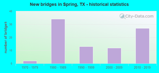
- New bridges - historical statistics
- 21970-1979
- 341980-1989
- 131990-1999
- 122000-2009
- 272010-2019
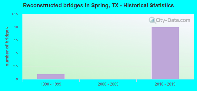
- Reconstructed bridges - Historical Statistics
- 11990-1999
- 02000-2009
- 102010-2019
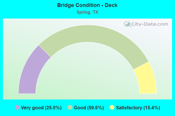
- Bridge Condition - Deck
- 25.0%Very good
- 59.6%Good
- 15.4%Satisfactory
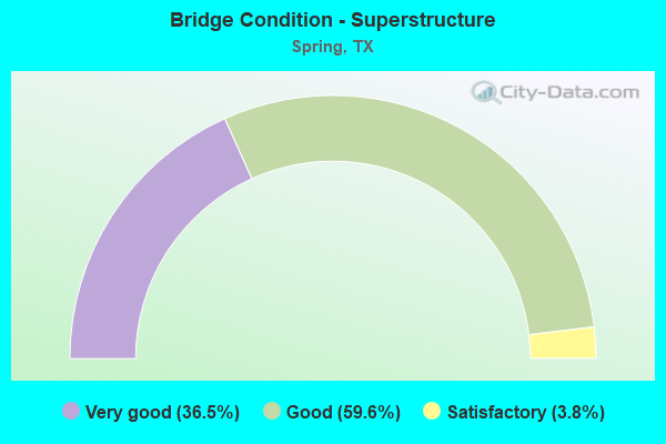
- Bridge Condition - Superstructure
- 36.5%Very good
- 59.6%Good
- 3.8%Satisfactory
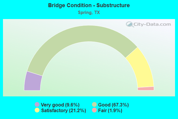
- Bridge Condition - Substructure
- 9.6%Very good
- 67.3%Good
- 21.2%Satisfactory
- 1.9%Fair
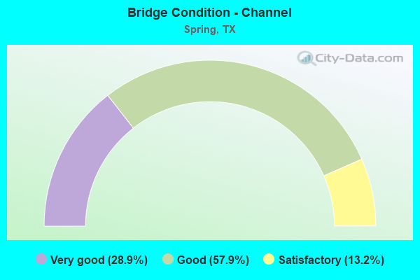
- Bridge Condition - Channel
- 28.9%Very good
- 57.9%Good
- 13.2%Satisfactory
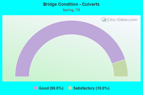
- Bridge Condition - Culverts
- 90.0%Good
- 10.0%Satisfactory
Find on map >> Show street view
Structure Number: 121020011005131, Location: 0.3 MI S MONTGOMERY C/L (Lat: 30.106586, Lng: -95.435039), Route carried "on" structure: ServiceInterstate 45, Year Built: 1988, Status: Open, Structure Length: 11.58m (37.99ft), Average Daily Traffic: 14,570 (year 2013), Truck Traffic: 7%, Average Future Daily Traffic: 20,390 (year 2033), Design Load: HS 20, Features Intersected: HARDY TOLL RD NB
Minimum Vertical Clearance: 30+ m (98+ ft), Kilometerpoint: 78.090, Lanes on structure: 3, Lanes under structure: 2, Owner: State Highway Agency, Approaching Roadway Width: 11.9m (39.0ft), Material/Design: Steel continuous, Design/Construction: Stringer/Multi-beam, Number Of Spans In Main Unit: 3, Length of Maximum Span: 45.7m (149.9ft), Curb-To-Curb Width: 11.9m (39.0ft), Out-to-Out Width: 12.7m (41.7ft)
Condition: Deck: Good, Superstructure: Good, Substructure: Good, Operating Rating: 44.4 metric tons, Method Used To Determine Operating Rating: Load Factor (LF), Inventory Rating: 32.7 metric tons, Method Used To Determine Inventory Rating: Load Factor (LF), Structural Evaluation: Better than present minimum criteria, Deck Geometry: High priority of corrective action, Underclear: Meets minimum limits, Approach Roadway Alignment: Equal to present desirable criteria, Length Of Structure Improvement: 11.58m (37.99ft), Designated Inspection Frequency: Every 24 months, Critical Feature Inspection Frequency: Every 24 months, Inspection Date: October 2020, Critical Feature Inspection Date: May 2020, Bridge Improvement Cost: $30,000, Roadway Improvement Cost: $8,000, Total Project Cost: $38,000, Deck Structure Type: Concrete Cast-file-Place
Find on map >> Show street view
Structure Number: 12102016850204, Location: 1.50 MI E OF IH 45 (Lat: 30.025661, Lng: -95.408947), Route carried "on" structure: State highway 1960, Year Built: 1990, Status: Open, Structure Length: 48.65m (159.61ft), Average Daily Traffic: 52,953 (year 2016), Truck Traffic: 4%, Average Future Daily Traffic: 84,000 (year 2031), Design Load: HS 20, Features Intersected: HARDY TOLL RD & UP RR
Minimum Vertical Clearance: 30+ m (98+ ft), Kilometerpoint: 25.989, Lanes on structure: 6, Lanes under structure: 18, Owner: State Highway Agency, Approaching Roadway Width: 34.1m (111.9ft), Material/Design: Prestressed concrete, Design/Construction: Stringer/Multi-beam, Number Of Spans In Main Unit: 4, Number Of Approach Spans: 12, Length of Maximum Span: 39.3m (128.9ft), Curb-To-Curb Width: 33.9m (111.2ft), Out-to-Out Width: 34.7m (113.8ft)
Condition: Deck: Satisfactory, Superstructure: Good, Substructure: Good, Operating Rating: 54.4 metric tons, Method Used To Determine Operating Rating: Assigned rating based on Load Factor Design (LFD) reported in metric tons, Inventory Rating: 32.7 metric tons, Method Used To Determine Inventory Rating: Assigned rating based on Load Factor Design (LFD) reported in metric tons, Structural Evaluation: Better than present minimum criteria, Deck Geometry: Superior to present desirable criteria, Underclear: Somewhat better than minimum adequacy, Approach Roadway Alignment: Equal to present desirable criteria, Length Of Structure Improvement: 48.65m (159.61ft), Designated Inspection Frequency: Every 24 months, Inspection Date: September 2020, Deck Structure Type: Concrete Cast-file-Place
Find on map >> Show street view
Structure Number: 121020168502057, Location: 1.50 MI E OF IH 45 (Lat: 30.026603, Lng: -95.404694), Route carried "on" structure: Other road , Year Built: 1990, Year Reconstructed: 2016, Status: Open, Structure Length: 11.34m (37.20ft), Average Daily Traffic: 15,000 (year 2016), Average Future Daily Traffic: 20,000 (year 2036), Design Load: HS 20, Features Intersected: FM 1960 FR, Facility Carried by Structure: HARDY TOLL RD SB
Minimum Vertical Clearance: 8.21m (26.94ft), Kilometerpoint: 89.866, Lanes on structure: 3, Lanes under structure: 7, Toll: On toll road, Owner: Local Toll Authority, Approaching Roadway Width: 17.1m (56.1ft), Material/Design: Prestressed concrete, Design/Construction: Stringer/Multi-beam, Number Of Spans In Main Unit: 5, Length of Maximum Span: 23.8m (78.1ft), Curb-To-Curb Width: 17.1m (56.1ft), Out-to-Out Width: 17.7m (58.1ft)
Condition: Deck: Good, Superstructure: Good, Substructure: Good, Operating Rating: 54.4 metric tons, Method Used To Determine Operating Rating: Assigned rating based on Load Factor Design (LFD) reported in metric tons, Inventory Rating: 32.7 metric tons, Method Used To Determine Inventory Rating: Assigned rating based on Load Factor Design (LFD) reported in metric tons, Structural Evaluation: Better than present minimum criteria, Deck Geometry: Equal to present minimum criteria, Underclear: Meets minimum limits, Approach Roadway Alignment: Equal to present desirable criteria, Designated Inspection Frequency: Every 24 months, Inspection Date: September 2020, Deck Structure Type: Concrete Cast-file-Place
Find on map >> Show street view
Structure Number: 121020168502058, Location: 1.50 MI E OF IH 45 (Lat: 30.026642, Lng: -95.404497), Route carried "on" structure: Other road , Year Built: 1990, Year Reconstructed: 2016, Status: Open, Structure Length: 11.34m (37.20ft), Average Daily Traffic: 15,000 (year 2016), Average Future Daily Traffic: 200 (year 2036), Design Load: HS 20, Features Intersected: FM 1960 FR, Facility Carried by Structure: HARDY TOLL RD NB
Minimum Vertical Clearance: 7.42m (24.34ft), Kilometerpoint: 89.866, Lanes on structure: 3, Lanes under structure: 7, Toll: On toll road, Owner: Local Toll Authority, Approaching Roadway Width: 17.1m (56.1ft), Material/Design: Prestressed concrete, Design/Construction: Stringer/Multi-beam, Number Of Spans In Main Unit: 5, Length of Maximum Span: 23.8m (78.1ft), Curb-To-Curb Width: 17.1m (56.1ft), Out-to-Out Width: 17.7m (58.1ft)
Condition: Deck: Good, Superstructure: Good, Substructure: Good, Operating Rating: 54.4 metric tons, Method Used To Determine Operating Rating: Assigned rating based on Load Factor Design (LFD) reported in metric tons, Inventory Rating: 32.7 metric tons, Method Used To Determine Inventory Rating: Assigned rating based on Load Factor Design (LFD) reported in metric tons, Structural Evaluation: Better than present minimum criteria, Deck Geometry: Equal to present minimum criteria, Underclear: Meets minimum limits, Approach Roadway Alignment: Equal to present desirable criteria, Designated Inspection Frequency: Every 24 months, Inspection Date: September 2020, Deck Structure Type: Concrete Cast-file-Place
Find on map >> Show street view
Structure Number: 121020351006131, Location: 0.42 MI E OF IH 45 (Lat: 30.092508, Lng: -95.428364), Route carried "on" structure: Other road 99, Year Built: 2016, Status: Open, Structure Length: 4.24m (13.91ft), Average Daily Traffic: 4,000 (year 2016), Truck Traffic: 2%, Average Future Daily Traffic: 6,000 (year 2036), Design Load: HL 93, Features Intersected: NORTHGATE CROSSING BLVD
Minimum Vertical Clearance: 30+ m (98+ ft), Kilometerpoint: 67.084, Lanes on structure: 2, Lanes under structure: 4, Toll: On toll road, Owner: State Highway Agency, Approaching Roadway Width: 14.0m (45.9ft), Skew: 2 degrees, Material/Design: Prestressed concrete, Design/Construction: Stringer/Multi-beam, Number Of Spans In Main Unit: 1, Length of Maximum Span: 42.4m (139.1ft), Curb-To-Curb Width: 12.9m (42.3ft), Out-to-Out Width: 13.6m (44.6ft)
Condition: Deck: Very good, Superstructure: Very good, Substructure: Very good, Operating Rating: 54.4 metric tons, Method Used To Determine Operating Rating: Assigned ratings based on Load and Resistance Factor Design (LRFD) reported in metric tons, Inventory Rating: 32.7 metric tons, Method Used To Determine Inventory Rating: Assigned ratings based on Load and Resistance Factor Design (LRFD) reported in metric tons, Structural Evaluation: Equal to present desirable criteria, Deck Geometry: Superior to present desirable criteria, Underclear: Superior to present desirable criteria, Approach Roadway Alignment: Equal to present desirable criteria, Designated Inspection Frequency: Every 24 months, Inspection Date: December 2020, Deck Structure Type: Concrete Precast Panels
Find on map >> Show street view
Structure Number: 121020351006132, Location: 0.9 MI E OF IH 45 (Lat: 30.092494, Lng: -95.422011), Route carried "on" structure: Other road 99, Year Built: 2016, Status: Open, Structure Length: 48.07m (157.71ft), Average Daily Traffic: 4,000 (year 2016), Truck Traffic: 2%, Average Future Daily Traffic: 6,000 (year 2036), Design Load: HL 93, Features Intersected: E HARDY RD; UP RAILROAD
Minimum Vertical Clearance: 30+ m (98+ ft), Kilometerpoint: 67.695, Lanes on structure: 2, Lanes under structure: 6, Toll: On toll road, Owner: State Highway Agency, Approaching Roadway Width: 14.0m (45.9ft), Skew: 9 degrees, Material/Design: Prestressed concrete, Design/Construction: Stringer/Multi-beam, Number Of Spans In Main Unit: 13, Length of Maximum Span: 39.6m (129.9ft), Curb-To-Curb Width: 14.0m (45.9ft), Out-to-Out Width: 14.6m (47.9ft)
Condition: Deck: Good, Superstructure: Very good, Substructure: Good, Operating Rating: 54.4 metric tons, Method Used To Determine Operating Rating: Assigned ratings based on Load and Resistance Factor Design (LRFD) reported in metric tons, Inventory Rating: 32.7 metric tons, Method Used To Determine Inventory Rating: Assigned ratings based on Load and Resistance Factor Design (LRFD) reported in metric tons, Structural Evaluation: Better than present minimum criteria, Deck Geometry: Superior to present desirable criteria, Underclear: High priority of corrective action, Approach Roadway Alignment: Equal to present desirable criteria, Designated Inspection Frequency: Every 24 months, Inspection Date: December 2020, Deck Structure Type: Concrete Precast Panels
Find on map >> Show street view
Structure Number: 121020351006134, Location: 0.42 MI E OF IH 45 (Lat: 30.092728, Lng: -95.428042), Route carried "on" structure: Other road 99, Year Built: 2016, Status: Open, Structure Length: 4.24m (13.91ft), Average Daily Traffic: 4,000 (year 2016), Truck Traffic: 2%, Average Future Daily Traffic: 6,000 (year 2036), Design Load: HL 93, Features Intersected: NORTHGATE CROSSING BLVD
Minimum Vertical Clearance: 30+ m (98+ ft), Kilometerpoint: 67.164, Lanes on structure: 2, Lanes under structure: 4, Toll: On toll road, Owner: State Highway Agency, Approaching Roadway Width: 11.6m (38.1ft), Skew: 2 degrees, Material/Design: Prestressed concrete, Design/Construction: Stringer/Multi-beam, Number Of Spans In Main Unit: 1, Length of Maximum Span: 42.4m (139.1ft), Curb-To-Curb Width: 11.3m (37.1ft), Out-to-Out Width: 12.2m (40.0ft)
Condition: Deck: Very good, Superstructure: Very good, Substructure: Very good, Operating Rating: 54.4 metric tons, Method Used To Determine Operating Rating: Assigned ratings based on Load and Resistance Factor Design (LRFD) reported in metric tons, Inventory Rating: 32.7 metric tons, Method Used To Determine Inventory Rating: Assigned ratings based on Load and Resistance Factor Design (LRFD) reported in metric tons, Structural Evaluation: Equal to present desirable criteria, Deck Geometry: Somewhat better than minimum adequacy, Underclear: Superior to present desirable criteria, Approach Roadway Alignment: Equal to present desirable criteria, Designated Inspection Frequency: Every 24 months, Inspection Date: December 2020, Deck Structure Type: Concrete Precast Panels
Find on map >> Show street view
Structure Number: 121020351006135, Location: 0.9 MI E OF IH 45 (Lat: 30.093331, Lng: -95.417072), Route carried "on" structure: Other road 99, Year Built: 2016, Status: Open, Structure Length: 48.62m (159.51ft), Average Daily Traffic: 4,000 (year 2016), Truck Traffic: 5%, Average Future Daily Traffic: 6,000 (year 2036), Design Load: HL 93, Features Intersected: E HARDY RD; UP RAILROAD
Minimum Vertical Clearance: 30+ m (98+ ft), Kilometerpoint: 67.921, Lanes on structure: 2, Lanes under structure: 6, Toll: On toll road, Owner: State Highway Agency, Approaching Roadway Width: 14.0m (45.9ft), Skew: 9 degrees, Material/Design: Prestressed concrete, Design/Construction: Stringer/Multi-beam, Number Of Spans In Main Unit: 13, Length of Maximum Span: 39.9m (130.9ft), Curb-To-Curb Width: 14.0m (45.9ft), Out-to-Out Width: 14.6m (47.9ft)
Condition: Deck: Good, Superstructure: Very good, Substructure: Good, Operating Rating: 54.4 metric tons, Method Used To Determine Operating Rating: Assigned ratings based on Load and Resistance Factor Design (LRFD) reported in metric tons, Inventory Rating: 32.7 metric tons, Method Used To Determine Inventory Rating: Assigned ratings based on Load and Resistance Factor Design (LRFD) reported in metric tons, Structural Evaluation: Better than present minimum criteria, Deck Geometry: Superior to present desirable criteria, Underclear: High priority of corrective action, Approach Roadway Alignment: Equal to present desirable criteria, Designated Inspection Frequency: Every 24 months, Inspection Date: December 2020, Deck Structure Type: Concrete Precast Panels
Find on map >> Show street view
Structure Number: 121020351006241, Location: 1.25 MI E OF IH 45 (Lat: 30.093525, Lng: -95.414117), Route carried "on" structure: Other road , Year Built: 2016, Status: Open, Structure Length: 6.49m (21.29ft), Average Daily Traffic: 4,000 (year 2016), Truck Traffic: 5%, Average Future Daily Traffic: 6,000 (year 2036), Design Load: HL 93, Features Intersected: HARDY TOLL RD, Facility Carried by Structure: SH 99 WB
Minimum Vertical Clearance: 30+ m (98+ ft), Kilometerpoint: 68.484, Lanes on structure: 2, Lanes under structure: 4, Toll: On toll road, Owner: State Highway Agency, Approaching Roadway Width: 11.6m (38.1ft), Skew: 1 degrees, Material/Design: Prestressed concrete, Design/Construction: Stringer/Multi-beam, Number Of Spans In Main Unit: 2, Length of Maximum Span: 32.3m (106.0ft), Curb-To-Curb Width: 11.4m (37.4ft), Out-to-Out Width: 12.2m (40.0ft)
Condition: Deck: Very good, Superstructure: Good, Substructure: Very good, Operating Rating: 54.4 metric tons, Method Used To Determine Operating Rating: Assigned ratings based on Load and Resistance Factor Design (LRFD) reported in metric tons, Inventory Rating: 32.7 metric tons, Method Used To Determine Inventory Rating: Assigned ratings based on Load and Resistance Factor Design (LRFD) reported in metric tons, Structural Evaluation: Better than present minimum criteria, Deck Geometry: Somewhat better than minimum adequacy, Underclear: Better than present minimum criteria, Approach Roadway Alignment: Equal to present desirable criteria, Designated Inspection Frequency: Every 24 months, Inspection Date: December 2020, Deck Structure Type: Concrete Precast Panels
Find on map >> Show street view
Structure Number: 121020351006242, Location: 1.25 MI E OF IH 45 (Lat: 30.093250, Lng: -95.414711), Route carried "on" structure: Other road , Year Built: 2016, Status: Open, Structure Length: 6.49m (21.29ft), Average Daily Traffic: 4,000 (year 2016), Truck Traffic: 2%, Average Future Daily Traffic: 6,000 (year 2036), Design Load: HL 93, Features Intersected: HARDY TOLL RD, Facility Carried by Structure: SH 99 EB
Minimum Vertical Clearance: 5.31m (17.42ft), Kilometerpoint: 68.420, Lanes on structure: 2, Lanes under structure: 4, Toll: On toll road, Owner: State Highway Agency, Approaching Roadway Width: 11.6m (38.1ft), Skew: 1 degrees, Material/Design: Prestressed concrete, Design/Construction: Stringer/Multi-beam, Number Of Spans In Main Unit: 2, Length of Maximum Span: 32.3m (106.0ft), Curb-To-Curb Width: 11.4m (37.4ft), Out-to-Out Width: 12.2m (40.0ft)
Condition: Deck: Very good, Superstructure: Good, Substructure: Very good, Operating Rating: 54.4 metric tons, Method Used To Determine Operating Rating: Assigned ratings based on Load and Resistance Factor Design (LRFD) reported in metric tons, Inventory Rating: 32.7 metric tons, Method Used To Determine Inventory Rating: Assigned ratings based on Load and Resistance Factor Design (LRFD) reported in metric tons, Structural Evaluation: Better than present minimum criteria, Deck Geometry: Somewhat better than minimum adequacy, Underclear: Superior to present desirable criteria, Approach Roadway Alignment: Equal to present desirable criteria, Designated Inspection Frequency: Every 24 months, Inspection Date: December 2020, Deck Structure Type: Concrete Precast Panels
Find on map >> Show street view
Structure Number: 121020351006249, Location: 1.05 MI E OF IH 45 (Lat: 30.092897, Lng: -95.417286), Route carried "on" structure: Ramp Other road 99, Year Built: 2016, Status: Open, Structure Length: 56.75m (186.19ft), Average Daily Traffic: 1,000 (year 2016), Truck Traffic: 3%, Average Future Daily Traffic: 2,000 (year 2036), Design Load: HL 93, Features Intersected: SPRING CREEK TRAIL
Minimum Vertical Clearance: 30+ m (98+ ft), Kilometerpoint: 0.000, Lanes on structure: 1, Lanes under structure: 2, Toll: On toll road, Owner: State Highway Agency, Approaching Roadway Width: 7.9m (25.9ft), Material/Design: Prestressed concrete, Design/Construction: Stringer/Multi-beam, Number Of Spans In Main Unit: 15, Length of Maximum Span: 38.1m (125.0ft), Curb-To-Curb Width: 7.8m (25.6ft), Out-to-Out Width: 8.5m (27.9ft)
Condition: Deck: Good, Superstructure: Good, Substructure: Good, Operating Rating: 54.4 metric tons, Method Used To Determine Operating Rating: Assigned ratings based on Load and Resistance Factor Design (LRFD) reported in metric tons, Inventory Rating: 32.7 metric tons, Method Used To Determine Inventory Rating: Assigned ratings based on Load and Resistance Factor Design (LRFD) reported in metric tons, Structural Evaluation: Better than present minimum criteria, Deck Geometry: Better than present minimum criteria, Underclear: Superior to present desirable criteria, Approach Roadway Alignment: Equal to present desirable criteria, Designated Inspection Frequency: Every 24 months, Inspection Date: December 2020, Deck Structure Type: Concrete Precast Panels
Find on map >> Show street view
Structure Number: 12102035100625, Location: 1.35 MI E OF IH 45 (Lat: 30.093969, Lng: -95.409469), Route carried "on" structure: Ramp State highway 99, Year Built: 2016, Status: Open, Structure Length: 69.34m (227.49ft), Average Daily Traffic: 750 (year 2016), Average Future Daily Traffic: 1,500 (year 2036), Design Load: HL 93, Features Intersected: SPRNG CK; SH 99; HARDYTL
Minimum Vertical Clearance: 30+ m (98+ ft), Kilometerpoint: 0.000, Lanes on structure: 1, Lanes under structure: 9, Owner: State Highway Agency, Approaching Roadway Width: 7.9m (25.9ft), Skew: 9 degrees, Material/Design: Steel continuous, Design/Construction: Stringer/Multi-beam, Number Of Spans In Main Unit: 4, Number Of Approach Spans: 13, Length of Maximum Span: 59.4m (194.9ft), Curb-To-Curb Width: 7.7m (25.3ft), Out-to-Out Width: 8.5m (27.9ft)
Condition: Deck: Good, Superstructure: Very good, Substructure: Satisfactory, Channel: Satisfactory, Operating Rating: 54.4 metric tons, Method Used To Determine Operating Rating: Assigned ratings based on Load and Resistance Factor Design (LRFD) reported in metric tons, Inventory Rating: 32.7 metric tons, Method Used To Determine Inventory Rating: Assigned ratings based on Load and Resistance Factor Design (LRFD) reported in metric tons, Structural Evaluation: Equal to present minimum criteria, Deck Geometry: Better than present minimum criteria, Underclear: Meets minimum limits, Waterway Adequacy: Superior to present desirable criteria, Approach Roadway Alignment: Equal to present desirable criteria, Designated Inspection Frequency: Every 24 months, Inspection Date: December 2020, Deck Structure Type: Concrete Cast-file-Place
Find on map >> Show street view
Structure Number: 121020351006251, Location: 1.25 MI E OF IH 45 (Lat: 30.091192, Lng: -95.413586), Route carried "on" structure: Ramp Other road , Year Built: 2016, Status: Open, Structure Length: 64.62m (212.01ft), Average Daily Traffic: 2,000 (year 2016), Average Future Daily Traffic: 4,000 (year 2036), Design Load: HL 93, Features Intersected: HARDY TOLL RD; SH 99, Facility Carried by Structure: SH 99 WB CONNECTOR
Minimum Vertical Clearance: 5.39m (17.68ft), Kilometerpoint: 0.000, Lanes on structure: 1, Lanes under structure: 11, Toll: On toll road, Owner: State Highway Agency, Approaching Roadway Width: 7.9m (25.9ft), Skew: 9 degrees, Material/Design: Steel, Design/Construction: Stringer/Multi-beam, Number Of Spans In Main Unit: 4, Number Of Approach Spans: 14, Length of Maximum Span: 52.7m (172.9ft), Curb-To-Curb Width: 7.9m (25.9ft), Out-to-Out Width: 8.5m (27.9ft)
Condition: Deck: Good, Superstructure: Very good, Substructure: Good, Operating Rating: 54.4 metric tons, Method Used To Determine Operating Rating: Assigned ratings based on Load and Resistance Factor Design (LRFD) reported in metric tons, Inventory Rating: 32.7 metric tons, Method Used To Determine Inventory Rating: Assigned ratings based on Load and Resistance Factor Design (LRFD) reported in metric tons, Structural Evaluation: Better than present minimum criteria, Deck Geometry: Equal to present desirable criteria, Underclear: High priority of corrective action, Approach Roadway Alignment: Equal to present desirable criteria, Designated Inspection Frequency: Every 24 months, Inspection Date: December 2020, Deck Structure Type: Concrete Cast-file-Place
Find on map >> Show street view
Structure Number: 121020351006252, Location: AT JCT HRDY TOLLRD, SH99 (Lat: 30.091228, Lng: -95.413394), Route carried "on" structure: Ramp State highway 99, Year Built: 2016, Status: Open, Structure Length: 39.65m (130.09ft), Average Daily Traffic: 750 (year 2016), Truck Traffic: 2%, Average Future Daily Traffic: 2,000 (year 2036), Design Load: HL 93, Features Intersected: SPRING CREEK FLOOD PLAIN
Minimum Vertical Clearance: 30+ m (98+ ft), Kilometerpoint: 0.000, Lanes on structure: 1, Owner: State Highway Agency, Approaching Roadway Width: 7.9m (25.9ft), Material/Design: Prestressed concrete, Design/Construction: Stringer/Multi-beam, Number Of Spans In Main Unit: 11, Length of Maximum Span: 36.6m (120.1ft), Curb-To-Curb Width: 7.8m (25.6ft), Out-to-Out Width: 8.5m (27.9ft)
Condition: Deck: Very good, Superstructure: Good, Substructure: Good, Channel: Good, Operating Rating: 54.4 metric tons, Method Used To Determine Operating Rating: Assigned ratings based on Load and Resistance Factor Design (LRFD) reported in metric tons, Inventory Rating: 32.7 metric tons, Method Used To Determine Inventory Rating: Assigned ratings based on Load and Resistance Factor Design (LRFD) reported in metric tons, Structural Evaluation: Better than present minimum criteria, Deck Geometry: Better than present minimum criteria, Waterway Adequacy: Superior to present desirable criteria, Approach Roadway Alignment: Equal to present desirable criteria, Designated Inspection Frequency: Every 24 months, Inspection Date: December 2020, Deck Structure Type: Concrete Precast Panels
Find on map >> Show street view
Structure Number: 121020AA2063003, Location: 0.4 MI S OF LOUETTA RD (Lat: 30.067831, Lng: -95.421461), Route carried "on" structure: County highway , Year Built: 1988, Status: Open, Structure Length: 1.25m (4.10ft), Average Daily Traffic: 7,632 (year 2015), Truck Traffic: 1%, Average Future Daily Traffic: 8,000 (year 2035), Features Intersected: LEMM GULLY, Facility Carried by Structure: LEXINGTON RD
Minimum Vertical Clearance: 30+ m (98+ ft), Kilometerpoint: 0.644, Lanes on structure: 4, Owner: County Highway Agency, Approaching Roadway Width: 13.7m (44.9ft), Skew: 24 degrees, Material/Design: Concrete, Design/Construction: Culvert, Number Of Spans In Main Unit: 2, Length of Maximum Span: 4.3m (14.1ft)
Condition: Channel: Good, Culverts: Good, Operating Rating: 32.7 metric tons, Method Used To Determine Operating Rating: Field evaluation and documented engineering judgment, Inventory Rating: 24.5 metric tons, Method Used To Determine Inventory Rating: Field evaluation and documented engineering judgment, Structural Evaluation: Equal to present minimum criteria, Waterway Adequacy: Better than present minimum criteria, Approach Roadway Alignment: Equal to present desirable criteria, Designated Inspection Frequency: Every 24 months, Inspection Date: September 2021
Find on map >> Show street view
Structure Number: 121020AA2063014, Location: 0.9 MI E OF IH 45 (Lat: 30.058014, Lng: -95.420178), Route carried "on" structure: County highway , Year Built: 1987, Status: Open, Structure Length: 6.74m (22.11ft), Average Daily Traffic: 5,000 (year 2015), Truck Traffic: 2%, Average Future Daily Traffic: 14,544 (year 2035), Features Intersected: LEMM GULLY, Facility Carried by Structure: CYPRESSWOOD DR NB
Minimum Vertical Clearance: 30+ m (98+ ft), Kilometerpoint: 1.448, Lanes on structure: 2, Owner: County Highway Agency, Approaching Roadway Width: 7.3m (24.0ft), Skew: 4 degrees, Material/Design: Prestressed concrete, Design/Construction: Box Beam or Girders - Multiple, Number Of Spans In Main Unit: 5, Length of Maximum Span: 13.7m (44.9ft), Curb or Sidewalk Widths: Left: 0.6m (2.0ft), Right: 1.7m (5.6ft), Curb-To-Curb Width: 7.3m (24.0ft), Out-to-Out Width: 10.4m (34.1ft)
Condition: Deck: Satisfactory, Superstructure: Good, Substructure: Good, Channel: Very good, Operating Rating: 32.7 metric tons, Method Used To Determine Operating Rating: Field evaluation and documented engineering judgment, Inventory Rating: 24.5 metric tons, Method Used To Determine Inventory Rating: Field evaluation and documented engineering judgment, Structural Evaluation: Equal to present minimum criteria, Deck Geometry: High priority of replacement, Waterway Adequacy: Better than present minimum criteria, Approach Roadway Alignment: Equal to present desirable criteria, Length Of Structure Improvement: 6.74m (22.11ft), Designated Inspection Frequency: Every 24 months, Inspection Date: September 2021, Bridge Improvement Cost: $11,000, Roadway Improvement Cost: $3,000, Total Project Cost: $14,000, Deck Structure Type: Concrete Cast-file-Place
Find on map >> Show street view
Structure Number: 121020AA2063015, Location: 0.9 MI E OF IH 45 (Lat: 30.058303, Lng: -95.420200), Route carried "on" structure: County highway , Year Built: 1987, Status: Open, Structure Length: 6.74m (22.11ft), Average Daily Traffic: 5,000 (year 2015), Truck Traffic: 2%, Average Future Daily Traffic: 14,500 (year 2035), Features Intersected: LEMM GULLY, Facility Carried by Structure: CYPRESSWOOD DR SB
Minimum Vertical Clearance: 30+ m (98+ ft), Kilometerpoint: 1.448, Lanes on structure: 2, Owner: County Highway Agency, Approaching Roadway Width: 7.3m (24.0ft), Skew: 4 degrees, Material/Design: Prestressed concrete, Design/Construction: Box Beam or Girders - Multiple, Number Of Spans In Main Unit: 5, Length of Maximum Span: 13.7m (44.9ft), Curb or Sidewalk Widths: Left: 1.7m (5.6ft), Right: 0.6m (2.0ft), Curb-To-Curb Width: 7.3m (24.0ft), Out-to-Out Width: 10.4m (34.1ft)
Condition: Deck: Satisfactory, Superstructure: Good, Substructure: Good, Channel: Very good, Operating Rating: 32.7 metric tons, Method Used To Determine Operating Rating: Field evaluation and documented engineering judgment, Inventory Rating: 24.5 metric tons, Method Used To Determine Inventory Rating: Field evaluation and documented engineering judgment, Structural Evaluation: Equal to present minimum criteria, Deck Geometry: High priority of replacement, Waterway Adequacy: Better than present minimum criteria, Approach Roadway Alignment: Equal to present desirable criteria, Length Of Structure Improvement: 6.95m (22.80ft), Designated Inspection Frequency: Every 24 months, Inspection Date: September 2021, Bridge Improvement Cost: $11,000, Roadway Improvement Cost: $3,000, Total Project Cost: $14,000, Deck Structure Type: Concrete Cast-file-Place
Find on map >> Show street view
Structure Number: 121020AA2063018, Location: 1.6 MI E OF IH 45 (Lat: 30.064672, Lng: -95.413358), Route carried "on" structure: County highway , Year Built: 1989, Status: Open, Structure Length: 65.23m (214.01ft), Average Daily Traffic: 3,000 (year 2012), Truck Traffic: 2%, Average Future Daily Traffic: 5,000 (year 2032), Design Load: HS 20, Features Intersected: UPRR & HARDY TOLL RD, Facility Carried by Structure: CYPRESSWOOD DR EB
Minimum Vertical Clearance: 30+ m (98+ ft), Kilometerpoint: 2.575, Lanes on structure: 2, Lanes under structure: 10, Owner: County Highway Agency, Approaching Roadway Width: 8.5m (27.9ft), Skew: 9 degrees, Material/Design: Prestressed concrete continuous, Design/Construction: Stringer/Multi-beam, Number Of Spans In Main Unit: 3, Number Of Approach Spans: 18, Length of Maximum Span: 54.3m (178.1ft), Curb or Sidewalk Widths: Left: 0.0m, Right: 1.5m (4.9ft), Curb-To-Curb Width: 8.5m (27.9ft), Out-to-Out Width: 11.0m (36.1ft)
Condition: Deck: Good, Superstructure: Good, Substructure: Fair, Operating Rating: 54.4 metric tons, Method Used To Determine Operating Rating: Assigned rating based on Load Factor Design (LFD) reported in metric tons, Inventory Rating: 32.7 metric tons, Method Used To Determine Inventory Rating: Assigned rating based on Load Factor Design (LFD) reported in metric tons, Structural Evaluation: Somewhat better than minimum adequacy, Deck Geometry: High priority of corrective action, Underclear: High priority of corrective action, Approach Roadway Alignment: Equal to present desirable criteria, Length Of Structure Improvement: 65.23m (214.01ft), Designated Inspection Frequency: Every 24 months, Inspection Date: October 2021, Bridge Improvement Cost: $120,000, Roadway Improvement Cost: $30,000, Total Project Cost: $150,000, Deck Structure Type: Concrete Cast-file-Place
Find on map >> Show street view
Structure Number: 121020AA2063019, Location: 1.6 MI E OF IH 45 (Lat: 30.064964, Lng: -95.412964), Route carried "on" structure: County highway , Year Built: 1989, Status: Open, Structure Length: 65.23m (214.01ft), Average Daily Traffic: 3,000 (year 2012), Truck Traffic: 2%, Average Future Daily Traffic: 5,000 (year 2032), Design Load: HS 20, Features Intersected: UPRR & HARDY TOLL RD, Facility Carried by Structure: CYPRESSWOOD DR WB
Minimum Vertical Clearance: 30+ m (98+ ft), Kilometerpoint: 2.575, Lanes on structure: 2, Lanes under structure: 10, Owner: County Highway Agency, Approaching Roadway Width: 8.5m (27.9ft), Skew: 9 degrees, Material/Design: Prestressed concrete continuous, Design/Construction: Stringer/Multi-beam, Number Of Spans In Main Unit: 3, Number Of Approach Spans: 18, Length of Maximum Span: 57.9m (190.0ft), Curb or Sidewalk Widths: Left: 0.0m, Right: 1.5m (4.9ft), Curb-To-Curb Width: 8.5m (27.9ft), Out-to-Out Width: 11.0m (36.1ft)
Condition: Deck: Good, Superstructure: Good, Substructure: Satisfactory, Operating Rating: 54.4 metric tons, Method Used To Determine Operating Rating: Assigned rating based on Load Factor Design (LFD) reported in metric tons, Inventory Rating: 32.7 metric tons, Method Used To Determine Inventory Rating: Assigned rating based on Load Factor Design (LFD) reported in metric tons, Structural Evaluation: Equal to present minimum criteria, Deck Geometry: High priority of corrective action, Underclear: Meets minimum limits, Approach Roadway Alignment: Equal to present desirable criteria, Length Of Structure Improvement: 65.23m (214.01ft), Designated Inspection Frequency: Every 24 months, Inspection Date: October 2021, Bridge Improvement Cost: $120,000, Roadway Improvement Cost: $30,000, Total Project Cost: $150,000, Deck Structure Type: Concrete Cast-file-Place
Find on map >> Show street view
Structure Number: 121020AA2111013, Location: 0.2 MI W OF HARDY TOLL RD (Lat: 30.073417, Lng: -95.416231), Route carried "on" structure: County highway , Year Built: 1989, Status: Open, Structure Length: 21.95m (72.01ft), Average Daily Traffic: 17,703 (year 2016), Truck Traffic: 3%, Average Future Daily Traffic: 10,130 (year 2033), Features Intersected: HARDY RD & UP RR YARD, Facility Carried by Structure: LOUETTA RD EB
Minimum Vertical Clearance: 30+ m (98+ ft), Kilometerpoint: 0.322, Lanes on structure: 2, Lanes under structure: 4, Owner: County Highway Agency, Approaching Roadway Width: 7.3m (24.0ft), Material/Design: Prestressed concrete, Design/Construction: Stringer/Multi-beam, Number Of Spans In Main Unit: 5, Number Of Approach Spans: 3, Length of Maximum Span: 38.1m (125.0ft), Curb or Sidewalk Widths: Left: 0.6m (2.0ft), Right: 1.8m (5.9ft), Curb-To-Curb Width: 7.3m (24.0ft), Out-to-Out Width: 10.4m (34.1ft)
Condition: Deck: Satisfactory, Superstructure: Good, Substructure: Satisfactory, Operating Rating: 32.7 metric tons, Method Used To Determine Operating Rating: Field evaluation and documented engineering judgment, Inventory Rating: 24.5 metric tons, Method Used To Determine Inventory Rating: Field evaluation and documented engineering judgment, Structural Evaluation: Equal to present minimum criteria, Deck Geometry: High priority of replacement, Underclear: Meets minimum limits, Approach Roadway Alignment: Equal to present desirable criteria, Length Of Structure Improvement: 21.95m (72.01ft), Designated Inspection Frequency: Every 24 months, Inspection Date: September 2021, Bridge Improvement Cost: $35,000, Roadway Improvement Cost: $9,000, Total Project Cost: $44,000, Deck Structure Type: Concrete Cast-file-Place
Find on map >> Show street view
Structure Number: 121020AA2111014, Location: 0.2 MI W OF HARDY TOLL RD (Lat: 30.073703, Lng: -95.415778), Route carried "on" structure: County highway , Year Built: 1982, Status: Open, Structure Length: 21.95m (72.01ft), Average Daily Traffic: 16,247 (year 2016), Truck Traffic: 3%, Average Future Daily Traffic: 10,130 (year 2033), Features Intersected: HARDY RD & UP RR YARD, Facility Carried by Structure: LOUETTA RD WB
Minimum Vertical Clearance: 30+ m (98+ ft), Kilometerpoint: 0.322, Lanes on structure: 2, Lanes under structure: 4, Owner: County Highway Agency, Approaching Roadway Width: 7.3m (24.0ft), Material/Design: Prestressed concrete, Design/Construction: Stringer/Multi-beam, Number Of Spans In Main Unit: 4, Number Of Approach Spans: 5, Length of Maximum Span: 36.6m (120.1ft), Curb or Sidewalk Widths: Left: 1.8m (5.9ft), Right: 0.6m (2.0ft), Curb-To-Curb Width: 7.3m (24.0ft), Out-to-Out Width: 10.4m (34.1ft)
Condition: Deck: Satisfactory, Superstructure: Good, Substructure: Satisfactory, Operating Rating: 32.7 metric tons, Method Used To Determine Operating Rating: Field evaluation and documented engineering judgment, Inventory Rating: 24.5 metric tons, Method Used To Determine Inventory Rating: Field evaluation and documented engineering judgment, Structural Evaluation: Equal to present minimum criteria, Deck Geometry: High priority of replacement, Underclear: Meets minimum limits, Approach Roadway Alignment: Equal to present desirable criteria, Length Of Structure Improvement: 21.95m (72.01ft), Designated Inspection Frequency: Every 24 months, Inspection Date: September 2021, Bridge Improvement Cost: $35,000, Roadway Improvement Cost: $9,000, Total Project Cost: $44,000, Deck Structure Type: Concrete Precast Panels
Find on map >> Show street view
Structure Number: 121020AA5498001, Location: 1.30 MI N OF FM 1960 (Lat: 30.031200, Lng: -95.330150), Route carried "on" structure: County highway , Year Built: 1982, Status: Open, Structure Length: 16.86m (55.31ft), Average Daily Traffic: 15,936 (year 2016), Truck Traffic: 2%, Average Future Daily Traffic: 14,300 (year 2035), Design Load: HS 20, Features Intersected: CYPRESS CREEK, Facility Carried by Structure: CYPRESSWOOD DR
Minimum Vertical Clearance: 30+ m (98+ ft), Kilometerpoint: 3.701, Lanes on structure: 4, Owner: County Highway Agency, Approaching Roadway Width: 18.3m (60.0ft), Skew: 3 degrees, Material/Design: Prestressed concrete, Design/Construction: Box Beam or Girders - Multiple, Number Of Spans In Main Unit: 12, Length of Maximum Span: 15.2m (49.9ft), Curb or Sidewalk Widths: Left: 1.5m (4.9ft), Right: 1.5m (4.9ft), Curb-To-Curb Width: 14.9m (48.9ft), Out-to-Out Width: 18.5m (60.7ft)
Condition: Deck: Very good, Superstructure: Good, Substructure: Satisfactory, Channel: Satisfactory, Operating Rating: 54.4 metric tons, Method Used To Determine Operating Rating: Assigned rating based on Load Factor Design (LFD) reported in metric tons, Inventory Rating: 32.7 metric tons, Method Used To Determine Inventory Rating: Assigned rating based on Load Factor Design (LFD) reported in metric tons, Structural Evaluation: Equal to present minimum criteria, Deck Geometry: High priority of replacement, Waterway Adequacy: Better than present minimum criteria, Approach Roadway Alignment: Equal to present desirable criteria, Length Of Structure Improvement: 16.86m (55.31ft), Designated Inspection Frequency: Every 24 months, Inspection Date: August 2021, Bridge Improvement Cost: $53,000, Roadway Improvement Cost: $13,000, Total Project Cost: $66,000, Deck Structure Type: Concrete Cast-file-Place, Wearing Surface/Protective System: Wearing Surface: Bituminous
Find on map >> Show street view
Structure Number: 121020AA5539001, Location: 0.50 MI E OF BIRNAMWOOD (Lat: 30.045908, Lng: -95.358533), Route carried "on" structure: County highway , Year Built: 1975, Status: Open, Structure Length: 2.80m (9.19ft), Average Daily Traffic: 2,230 (year 2015), Average Future Daily Traffic: 2,630 (year 2035), Features Intersected: WILD COW GULCH, Facility Carried by Structure: REYNALDO DR
Minimum Vertical Clearance: 30+ m (98+ ft), Kilometerpoint: 0.483, Lanes on structure: 2, Owner: County Highway Agency, Approaching Roadway Width: 8.2m (26.9ft), Material/Design: Prestressed concrete, Design/Construction: Box Beam or Girders - Multiple, Number Of Spans In Main Unit: 3, Length of Maximum Span: 9.1m (29.9ft), Curb or Sidewalk Widths: Left: 1.2m (3.9ft), Right: 1.2m (3.9ft), Curb-To-Curb Width: 8.3m (27.2ft), Out-to-Out Width: 11.3m (37.1ft)
Condition: Deck: Satisfactory, Superstructure: Good, Substructure: Satisfactory, Channel: Good, Operating Rating: 32.7 metric tons, Method Used To Determine Operating Rating: Field evaluation and documented engineering judgment, Inventory Rating: 24.5 metric tons, Method Used To Determine Inventory Rating: Field evaluation and documented engineering judgment, Structural Evaluation: Equal to present minimum criteria, Deck Geometry: High priority of corrective action, Waterway Adequacy: Better than present minimum criteria, Approach Roadway Alignment: Equal to present desirable criteria, Designated Inspection Frequency: Every 24 months, Inspection Date: September 2021, Deck Structure Type: Concrete Cast-file-Place
Find on map >> Show street view
Structure Number: 121020AA5720001, Location: 0.7 MI SE OF CYPRESSWOD (Lat: 30.045467, Lng: -95.419778), Route carried "on" structure: County highway , Year Built: 1970, Status: Posted for load, Structure Length: 3.11m (10.20ft), Average Daily Traffic: 1,480 (year 2015), Average Future Daily Traffic: 1,500 (year 2035), Features Intersected: LEMM GULLY, Facility Carried by Structure: LOCKRIDGE DR
Minimum Vertical Clearance: 30+ m (98+ ft), Kilometerpoint: 1.127, Lanes on structure: 2, Owner: County Highway Agency, Approaching Roadway Width: 6.1m (20.0ft), Material/Design: Concrete, Design/Construction: Slab, Number Of Spans In Main Unit: 4, Length of Maximum Span: 7.6m (24.9ft), Curb-To-Curb Width: 7.1m (23.3ft), Out-to-Out Width: 7.7m (25.3ft)
Condition: Deck: Satisfactory, Superstructure: Satisfactory, Substructure: Satisfactory, Channel: Good, Operating Rating: 35.4 metric tons, Method Used To Determine Operating Rating: Allowable Stress (AS), Inventory Rating: 22.7 metric tons, Method Used To Determine Inventory Rating: Allowable Stress (AS), Structural Evaluation: Equal to present minimum criteria, Deck Geometry: High priority of corrective action, Waterway Adequacy: Better than present minimum criteria, Approach Roadway Alignment: Equal to present desirable criteria, Bridge Posting: Required (Relationship of Operating Rating to Maximum Legal Load: 0.1 - 9.9% below), Length Of Structure Improvement: 3.11m (10.20ft), Designated Inspection Frequency: Every 24 months, Inspection Date: September 2021, Bridge Improvement Cost: $5,000, Roadway Improvement Cost: $1,000, Total Project Cost: $6,000, Deck Structure Type: Concrete Cast-file-Place, Wearing Surface/Protective System: Wearing Surface: Bituminous
Find on map >> Show street view
Structure Number: 121020AA5733001, Location: 0.05 MI E OF IH 45 (Lat: 30.042356, Lng: -95.428247), Route carried "on" structure: County highway , Year Built: 1980, Status: Open, Structure Length: 2.01m (6.59ft), Average Daily Traffic: 750 (year 2015), Truck Traffic: 1%, Average Future Daily Traffic: 1,000 (year 2035), Features Intersected: SENGER GULLY, Facility Carried by Structure: E NORTH HILL DR
Minimum Vertical Clearance: 30+ m (98+ ft), Kilometerpoint: 0.483, Lanes on structure: 2, Owner: County Highway Agency, Approaching Roadway Width: 6.1m (20.0ft), Material/Design: Prestressed concrete, Design/Construction: Box Beam or Girders - Multiple, Number Of Spans In Main Unit: 2, Length of Maximum Span: 10.1m (33.1ft), Curb or Sidewalk Widths: Left: 0.9m (3.0ft), Right: 0.9m (3.0ft), Curb-To-Curb Width: 7.3m (24.0ft), Out-to-Out Width: 9.8m (32.2ft)
Condition: Deck: Good, Superstructure: Very good, Substructure: Good, Channel: Very good, Operating Rating: 32.7 metric tons, Method Used To Determine Operating Rating: Field evaluation and documented engineering judgment, Inventory Rating: 24.5 metric tons, Method Used To Determine Inventory Rating: Field evaluation and documented engineering judgment, Structural Evaluation: Equal to present minimum criteria, Deck Geometry: Meets minimum limits, Waterway Adequacy: Better than present minimum criteria, Approach Roadway Alignment: Equal to present desirable criteria, Designated Inspection Frequency: Every 24 months, Inspection Date: October 2021, Deck Structure Type: Concrete Cast-file-Place
Find on map >> Show street view
Structure Number: 121020AA5744001, Location: 0.9 MI NE OF ALDINE WSFD (Lat: 30.091725, Lng: -95.406144), Route carried "on" structure: County highway , Year Built: 2007, Status: Open, Structure Length: 12.19m (39.99ft), Average Daily Traffic: 3,180 (year 2013), Truck Traffic: 2%, Average Future Daily Traffic: 5,100 (year 2033), Design Load: HS 20, Features Intersected: SPRING CREEK, Facility Carried by Structure: RILEY FUZZEL RD
Minimum Vertical Clearance: 30+ m (98+ ft), Kilometerpoint: 1.448, Lanes on structure: 4, Owner: County Highway Agency, Approaching Roadway Width: 20.1m (65.9ft), Skew: 3 degrees, Material/Design: Prestressed concrete, Design/Construction: Stringer/Multi-beam, Number Of Spans In Main Unit: 1, Number Of Approach Spans: 5, Length of Maximum Span: 30.5m (100.1ft), Curb or Sidewalk Widths: Left: 1.3m (4.3ft), Right: 1.3m (4.3ft), Curb-To-Curb Width: 14.6m (47.9ft), Out-to-Out Width: 20.2m (66.3ft)
Condition: Deck: Good, Superstructure: Good, Substructure: Good, Channel: Good, Operating Rating: 54.4 metric tons, Method Used To Determine Operating Rating: Assigned rating based on Load Factor Design (LFD) reported in metric tons, Inventory Rating: 32.7 metric tons, Method Used To Determine Inventory Rating: Assigned rating based on Load Factor Design (LFD) reported in metric tons, Structural Evaluation: Better than present minimum criteria, Deck Geometry: High priority of replacement, Waterway Adequacy: Superior to present desirable criteria, Approach Roadway Alignment: Equal to present desirable criteria, Length Of Structure Improvement: 12.19m (39.99ft), Designated Inspection Frequency: Every 24 months, Inspection Date: September 2021, Bridge Improvement Cost: $38,000, Roadway Improvement Cost: $10,000, Total Project Cost: $48,000, Deck Structure Type: Concrete Precast Panels
Find on map >> Show street view
Structure Number: 121020AA5775023, Location: 0.30 MI N OF FM 1960 (Lat: 30.030272, Lng: -95.405033), Route carried "on" structure: County highway , Year Built: 1988, Status: Open, Structure Length: 18.29m (60.01ft), Average Daily Traffic: 4,053 (year 2019), Truck Traffic: 2%, Average Future Daily Traffic: 2,000 (year 2035), Design Load: HS 20, Features Intersected: CYPRESS CREEK, Facility Carried by Structure: HARDY RD SB
Minimum Vertical Clearance: 30+ m (98+ ft), Kilometerpoint: 8.690, Lanes on structure: 2, Owner: County Highway Agency, Approaching Roadway Width: 7.3m (24.0ft), Material/Design: Prestressed concrete, Design/Construction: Stringer/Multi-beam, Number Of Spans In Main Unit: 6, Length of Maximum Span: 30.5m (100.1ft), Curb or Sidewalk Widths: Left: 1.5m (4.9ft), Right: 0.7m (2.3ft), Curb-To-Curb Width: 7.3m (24.0ft), Out-to-Out Width: 10.1m (33.1ft)
Condition: Deck: Good, Superstructure: Good, Substructure: Good, Channel: Good, Operating Rating: 54.4 metric tons, Method Used To Determine Operating Rating: Assigned rating based on Load Factor Design (LFD) reported in metric tons, Inventory Rating: 32.7 metric tons, Method Used To Determine Inventory Rating: Assigned rating based on Load Factor Design (LFD) reported in metric tons, Structural Evaluation: Better than present minimum criteria, Deck Geometry: High priority of replacement, Waterway Adequacy: Superior to present desirable criteria, Approach Roadway Alignment: Equal to present desirable criteria, Length Of Structure Improvement: 18.29m (60.01ft), Designated Inspection Frequency: Every 24 months, Inspection Date: October 2021, Bridge Improvement Cost: $29,000, Roadway Improvement Cost: $7,000, Total Project Cost: $36,000, Deck Structure Type: Concrete Precast Panels
Find on map >> Show street view
Structure Number: 121020AA5775024, Location: 0.30 MI N OF FM 1960 (Lat: 30.030453, Lng: -95.405000), Route carried "on" structure: County highway , Year Built: 1988, Status: Open, Structure Length: 18.29m (60.01ft), Average Daily Traffic: 2,000 (year 2015), Truck Traffic: 2%, Average Future Daily Traffic: 2,000 (year 2035), Design Load: HS 20, Features Intersected: CYPRESS CREEK, Facility Carried by Structure: HARDY RD NB
Minimum Vertical Clearance: 30+ m (98+ ft), Kilometerpoint: 8.690, Lanes on structure: 2, Owner: County Highway Agency, Approaching Roadway Width: 7.3m (24.0ft), Material/Design: Prestressed concrete, Design/Construction: Stringer/Multi-beam, Number Of Spans In Main Unit: 6, Length of Maximum Span: 30.5m (100.1ft), Curb or Sidewalk Widths: Left: 0.7m (2.3ft), Right: 1.6m (5.2ft), Curb-To-Curb Width: 7.3m (24.0ft), Out-to-Out Width: 10.1m (33.1ft)
Condition: Deck: Good, Superstructure: Good, Substructure: Good, Channel: Good, Operating Rating: 54.4 metric tons, Method Used To Determine Operating Rating: Assigned rating based on Load Factor Design (LFD) reported in metric tons, Inventory Rating: 32.7 metric tons, Method Used To Determine Inventory Rating: Assigned rating based on Load Factor Design (LFD) reported in metric tons, Structural Evaluation: Better than present minimum criteria, Deck Geometry: High priority of replacement, Waterway Adequacy: Superior to present desirable criteria, Approach Roadway Alignment: Equal to present desirable criteria, Length Of Structure Improvement: 18.29m (60.01ft), Designated Inspection Frequency: Every 24 months, Inspection Date: October 2021, Bridge Improvement Cost: $29,000, Roadway Improvement Cost: $7,000, Total Project Cost: $36,000, Deck Structure Type: Concrete Precast Panels
Find on map >> Show street view
Structure Number: 121020AA5775028, Location: 0.50 MI N OF FM 1960 (Lat: 30.032978, Lng: -95.405767), Route carried "on" structure: County highway , Year Built: 1990, Status: Open, Structure Length: 5.49m (18.01ft), Average Daily Traffic: 2,000 (year 2015), Truck Traffic: 2%, Average Future Daily Traffic: 2,000 (year 2035), Features Intersected: CYPRESS CREEK RELIEF, Facility Carried by Structure: HARDY RD SB
Minimum Vertical Clearance: 30+ m (98+ ft), Kilometerpoint: 8.369, Lanes on structure: 2, Owner: County Highway Agency, Approaching Roadway Width: 7.3m (24.0ft), Material/Design: Prestressed concrete, Design/Construction: Stringer/Multi-beam, Number Of Spans In Main Unit: 3, Length of Maximum Span: 18.3m (60.0ft), Curb or Sidewalk Widths: Left: 1.5m (4.9ft), Right: 0.7m (2.3ft), Curb-To-Curb Width: 7.3m (24.0ft), Out-to-Out Width: 10.1m (33.1ft)
Condition: Deck: Good, Superstructure: Good, Substructure: Good, Channel: Good, Operating Rating: 32.7 metric tons, Method Used To Determine Operating Rating: Field evaluation and documented engineering judgment, Inventory Rating: 24.5 metric tons, Method Used To Determine Inventory Rating: Field evaluation and documented engineering judgment, Structural Evaluation: Equal to present minimum criteria, Deck Geometry: High priority of replacement, Waterway Adequacy: Better than present minimum criteria, Approach Roadway Alignment: Equal to present desirable criteria, Length Of Structure Improvement: 5.49m (18.01ft), Designated Inspection Frequency: Every 24 months, Inspection Date: October 2021, Bridge Improvement Cost: $9,000, Roadway Improvement Cost: $2,000, Total Project Cost: $11,000, Deck Structure Type: Concrete Precast Panels
Find on map >> Show street view
Structure Number: 121020AA5775029, Location: 0.50 MI N OF FM 1960 (Lat: 30.033214, Lng: -95.405733), Route carried "on" structure: County highway , Year Built: 1990, Status: Open, Structure Length: 5.49m (18.01ft), Average Daily Traffic: 2,000 (year 2015), Truck Traffic: 2%, Average Future Daily Traffic: 2,000 (year 2035), Features Intersected: CYPRESS CREEK RELIEF, Facility Carried by Structure: HARDY RD NB
Minimum Vertical Clearance: 30+ m (98+ ft), Kilometerpoint: 8.369, Lanes on structure: 2, Owner: County Highway Agency, Approaching Roadway Width: 7.3m (24.0ft), Material/Design: Prestressed concrete, Design/Construction: Stringer/Multi-beam, Number Of Spans In Main Unit: 3, Length of Maximum Span: 18.3m (60.0ft), Curb or Sidewalk Widths: Left: 0.7m (2.3ft), Right: 1.6m (5.2ft), Curb-To-Curb Width: 7.3m (24.0ft), Out-to-Out Width: 10.1m (33.1ft)
Condition: Deck: Satisfactory, Superstructure: Good, Substructure: Good, Channel: Very good, Operating Rating: 32.7 metric tons, Method Used To Determine Operating Rating: Field evaluation and documented engineering judgment, Inventory Rating: 24.5 metric tons, Method Used To Determine Inventory Rating: Field evaluation and documented engineering judgment, Structural Evaluation: Equal to present minimum criteria, Deck Geometry: High priority of replacement, Waterway Adequacy: Better than present minimum criteria, Approach Roadway Alignment: Equal to present desirable criteria, Length Of Structure Improvement: 5.49m (18.01ft), Designated Inspection Frequency: Every 24 months, Inspection Date: October 2021, Bridge Improvement Cost: $9,000, Roadway Improvement Cost: $2,000, Total Project Cost: $11,000, Deck Structure Type: Concrete Precast Panels
Find on map >> Show street view
Structure Number: 121020AA8893001, Location: 0.6 MI S OF SPRING CYPR (Lat: 30.072725, Lng: -95.420697), Route carried "on" structure: County highway , Year Built: 1983, Year Reconstructed: 1990, Status: Open, Structure Length: 3.11m (10.20ft), Average Daily Traffic: 33,950 (year 2016), Truck Traffic: 2%, Average Future Daily Traffic: 30,500 (year 2033), Features Intersected: LEMM GULLY, Facility Carried by Structure: LOUETTA RD
Minimum Vertical Clearance: 30+ m (98+ ft), Kilometerpoint: 0.966, Lanes on structure: 4, Owner: County Highway Agency, Approaching Roadway Width: 19.5m (64.0ft), Skew: 2 degrees, Material/Design: Prestressed concrete, Design/Construction: Box Beam or Girders - Multiple, Number Of Spans In Main Unit: 3, Length of Maximum Span: 10.1m (33.1ft), Curb or Sidewalk Widths: Left: 1.5m (4.9ft), Right: 1.5m (4.9ft), Curb-To-Curb Width: 19.5m (64.0ft), Out-to-Out Width: 23.0m (75.5ft)
Condition: Deck: Good, Superstructure: Very good, Substructure: Good, Channel: Good, Operating Rating: 32.7 metric tons, Method Used To Determine Operating Rating: Field evaluation and documented engineering judgment, Inventory Rating: 24.5 metric tons, Method Used To Determine Inventory Rating: Field evaluation and documented engineering judgment, Structural Evaluation: Equal to present minimum criteria, Deck Geometry: Better than present minimum criteria, Waterway Adequacy: Equal to present minimum criteria, Approach Roadway Alignment: Equal to present desirable criteria, Designated Inspection Frequency: Every 24 months, Inspection Date: September 2021, Deck Structure Type: Concrete Cast-file-Place
Find on map >> Show street view
Structure Number: 121020AA9009001, Location: 0.2 MI N OF CYPRESSWOOD D (Lat: 30.070900, Lng: -95.382492), Route carried "on" structure: County highway , Year Built: 2005, Status: Open, Structure Length: 2.77m (9.09ft), Average Daily Traffic: 20 (year 2009), Average Future Daily Traffic: 150 (year 2029), Design Load: HS 20, Features Intersected: HCFCD DITCH, Facility Carried by Structure: BIRNAMWOOD DR NB
Minimum Vertical Clearance: 30+ m (98+ ft), Kilometerpoint: 0.002, Lanes on structure: 2, Owner: County Highway Agency, Approaching Roadway Width: 7.3m (24.0ft), Skew: 1 degrees, Material/Design: Prestressed concrete, Design/Construction: Box Beam or Girders - Multiple, Number Of Spans In Main Unit: 3, Length of Maximum Span: 9.1m (29.9ft), Curb or Sidewalk Widths: Left: 0.6m (2.0ft), Right: 1.9m (6.2ft), Curb-To-Curb Width: 7.3m (24.0ft), Out-to-Out Width: 10.4m (34.1ft)
Condition: Deck: Good, Superstructure: Very good, Substructure: Good, Channel: Good, Operating Rating: 54.4 metric tons, Method Used To Determine Operating Rating: Assigned rating based on Load Factor Design (LFD) reported in metric tons, Inventory Rating: 32.7 metric tons, Method Used To Determine Inventory Rating: Assigned rating based on Load Factor Design (LFD) reported in metric tons, Structural Evaluation: Better than present minimum criteria, Deck Geometry: Equal to present minimum criteria, Waterway Adequacy: Superior to present desirable criteria, Approach Roadway Alignment: Equal to present desirable criteria, Designated Inspection Frequency: Every 24 months, Inspection Date: September 2021, Deck Structure Type: Concrete Cast-file-Place
Find on map >> Show street view
Structure Number: 121020AA9009002, Location: 0.4 MI SE OF CYPRESSWOOD (Lat: 30.063158, Lng: -95.377594), Route carried "on" structure: County highway , Year Built: 2009, Status: Open, Structure Length: 1.98m (6.50ft), Average Daily Traffic: 50 (year 2010), Average Future Daily Traffic: 150 (year 2030), Design Load: HS 20, Features Intersected: HCFCD DITCH J-109-01-01, Facility Carried by Structure: BIRNAMWOOD DR
Minimum Vertical Clearance: 30+ m (98+ ft), Kilometerpoint: 0.644, Lanes on structure: 2, Owner: County Highway Agency, Approaching Roadway Width: 7.3m (24.0ft), Material/Design: Prestressed concrete, Design/Construction: Box Beam or Girders - Multiple, Number Of Spans In Main Unit: 1, Length of Maximum Span: 19.8m (65.0ft), Curb or Sidewalk Widths: Left: 1.8m (5.9ft), Right: 0.6m (2.0ft), Curb-To-Curb Width: 7.3m (24.0ft), Out-to-Out Width: 10.4m (34.1ft)
Condition: Deck: Good, Superstructure: Very good, Substructure: Very good, Channel: Good, Operating Rating: 54.4 metric tons, Method Used To Determine Operating Rating: Assigned rating based on Load Factor Design (LFD) reported in metric tons, Inventory Rating: 32.7 metric tons, Method Used To Determine Inventory Rating: Assigned rating based on Load Factor Design (LFD) reported in metric tons, Structural Evaluation: Equal to present desirable criteria, Deck Geometry: Equal to present minimum criteria, Waterway Adequacy: Superior to present desirable criteria, Approach Roadway Alignment: Equal to present desirable criteria, Designated Inspection Frequency: Every 24 months, Inspection Date: September 2021, Deck Structure Type: Concrete Cast-file-Place
Find on map >> Show street view
Structure Number: 121020AA9009003, Location: 0.2 mi N of Cypresswood D (Lat: 30.071014, Lng: -95.382731), Route carried "on" structure: County highway , Year Built: 2012, Status: Open, Structure Length: 2.77m (9.09ft), Average Daily Traffic: 20 (year 2009), Average Future Daily Traffic: 150 (year 2028), Design Load: HS 20, Features Intersected: HCFCD Ditch, Facility Carried by Structure: Birnamwood DR SB
Minimum Vertical Clearance: 30+ m (98+ ft), Kilometerpoint: 0.322, Lanes on structure: 2, Owner: County Highway Agency, Approaching Roadway Width: 7.3m (24.0ft), Skew: 1 degrees, Material/Design: Prestressed concrete, Design/Construction: Box Beam or Girders - Multiple, Number Of Spans In Main Unit: 3, Length of Maximum Span: 9.1m (29.9ft), Curb-To-Curb Width: 7.3m (24.0ft), Out-to-Out Width: 10.4m (34.1ft)
Condition: Deck: Good, Superstructure: Very good, Substructure: Good, Channel: Good, Operating Rating: 54.4 metric tons, Method Used To Determine Operating Rating: Assigned rating based on Load Factor Design (LFD) reported in metric tons, Inventory Rating: 32.7 metric tons, Method Used To Determine Inventory Rating: Assigned rating based on Load Factor Design (LFD) reported in metric tons, Structural Evaluation: Better than present minimum criteria, Deck Geometry: High priority of replacement, Waterway Adequacy: Superior to present desirable criteria, Approach Roadway Alignment: Equal to present desirable criteria, Designated Inspection Frequency: Every 24 months, Inspection Date: September 2021, Deck Structure Type: Concrete Cast-file-Place
Find on map >> Show street view
Structure Number: 121020AA9022001, Location: 0.04 MI NE OF SPRING DANE (Lat: 30.065836, Lng: -95.376094), Route carried "on" structure: County highway , Year Built: 2005, Status: Open, Structure Length: 2.44m (8.01ft), Average Daily Traffic: 100 (year 2015), Average Future Daily Traffic: 150 (year 2035), Design Load: HS 20, Features Intersected: HCFCD DITCH, Facility Carried by Structure: SPRING SHANNON DR
Minimum Vertical Clearance: 30+ m (98+ ft), Kilometerpoint: 0.064, Lanes on structure: 2, Owner: County Highway Agency, Approaching Roadway Width: 7.9m (25.9ft), Material/Design: Prestressed concrete, Design/Construction: Box Beam or Girders - Multiple, Number Of Spans In Main Unit: 1, Length of Maximum Span: 24.4m (80.1ft), Curb or Sidewalk Widths: Left: 0.6m (2.0ft), Right: 1.8m (5.9ft), Curb-To-Curb Width: 8.2m (26.9ft), Out-to-Out Width: 11.3m (37.1ft)
Condition: Deck: Good, Superstructure: Very good, Substructure: Good, Channel: Good, Operating Rating: 54.4 metric tons, Method Used To Determine Operating Rating: Assigned rating based on Load Factor Design (LFD) reported in metric tons, Inventory Rating: 32.7 metric tons, Method Used To Determine Inventory Rating: Assigned rating based on Load Factor Design (LFD) reported in metric tons, Structural Evaluation: Better than present minimum criteria, Deck Geometry: Equal to present minimum criteria, Waterway Adequacy: Superior to present desirable criteria, Approach Roadway Alignment: Equal to present desirable criteria, Designated Inspection Frequency: Every 24 months, Inspection Date: September 2021, Deck Structure Type: Concrete Cast-file-Place
Find on map >> Show street view
Structure Number: 121020AA9955001, Location: 0.70 MI E OF IH 45 (Lat: 30.106325, Lng: -95.426911), Route carried "on" structure: County highway , Year Built: 1991, Status: Open, Structure Length: 1.68m (5.51ft), Average Daily Traffic: 453 (year 2016), Average Future Daily Traffic: 1,000 (year 2032), Features Intersected: HCFCD DITCH, Facility Carried by Structure: NORTHGATE X'ING SB
Minimum Vertical Clearance: 30+ m (98+ ft), Kilometerpoint: 1.127, Lanes on structure: 2, Owner: County Highway Agency, Approaching Roadway Width: 7.3m (24.0ft), Skew: 1 degrees, Material/Design: Prestressed concrete, Design/Construction: Box Beam or Girders - Multiple, Number Of Spans In Main Unit: 1, Length of Maximum Span: 16.5m (54.1ft), Curb or Sidewalk Widths: Left: 1.6m (5.2ft), Right: 0.0m, Curb-To-Curb Width: 7.2m (23.6ft), Out-to-Out Width: 9.8m (32.2ft)
Condition: Deck: Good, Superstructure: Very good, Substructure: Good, Channel: Very good, Operating Rating: 32.7 metric tons, Method Used To Determine Operating Rating: Field evaluation and documented engineering judgment, Inventory Rating: 24.5 metric tons, Method Used To Determine Inventory Rating: Field evaluation and documented engineering judgment, Structural Evaluation: Equal to present minimum criteria, Deck Geometry: High priority of replacement, Waterway Adequacy: Better than present minimum criteria, Approach Roadway Alignment: Equal to present desirable criteria, Designated Inspection Frequency: Every 24 months, Inspection Date: November 2021, Deck Structure Type: Concrete Cast-file-Place
Find on map >> Show street view
Structure Number: 121020AA9955002, Location: 0.70 MI E OF IH 45 (Lat: 30.106258, Lng: -95.426725), Route carried "on" structure: County highway , Year Built: 1991, Status: Open, Structure Length: 1.68m (5.51ft), Average Daily Traffic: 807 (year 2016), Average Future Daily Traffic: 1,000 (year 2032), Features Intersected: HCFCD DITCH, Facility Carried by Structure: NORTHGATE X'ING NB
Minimum Vertical Clearance: 30+ m (98+ ft), Kilometerpoint: 1.127, Lanes on structure: 2, Owner: County Highway Agency, Approaching Roadway Width: 7.3m (24.0ft), Skew: 1 degrees, Material/Design: Prestressed concrete, Design/Construction: Box Beam or Girders - Multiple, Number Of Spans In Main Unit: 1, Length of Maximum Span: 16.5m (54.1ft), Curb or Sidewalk Widths: Left: 0.0m, Right: 1.6m (5.2ft), Curb-To-Curb Width: 7.2m (23.6ft), Out-to-Out Width: 9.8m (32.2ft)
Condition: Deck: Good, Superstructure: Good, Substructure: Good, Channel: Very good, Operating Rating: 32.7 metric tons, Method Used To Determine Operating Rating: Field evaluation and documented engineering judgment, Inventory Rating: 24.5 metric tons, Method Used To Determine Inventory Rating: Field evaluation and documented engineering judgment, Structural Evaluation: Equal to present minimum criteria, Deck Geometry: High priority of replacement, Waterway Adequacy: Better than present minimum criteria, Approach Roadway Alignment: Equal to present desirable criteria, Designated Inspection Frequency: Every 24 months, Inspection Date: November 2021, Deck Structure Type: Concrete Cast-file-Place
Find on map >> Show street view
Structure Number: 121020AA9955003, Location: 0.6 MI SE OF IH 45 (Lat: 30.102722, Lng: -95.429508), Route carried "on" structure: County highway , Year Built: 1988, Status: Open, Structure Length: 5.18m (16.99ft), Average Daily Traffic: 110 (year 2009), Average Future Daily Traffic: 200 (year 2029), Design Load: HS 20, Features Intersected: HARDY TOLL RD, Facility Carried by Structure: NORTHGATE CROSSING
Minimum Vertical Clearance: 30+ m (98+ ft), Kilometerpoint: 1.609, Lanes on structure: 6, Lanes under structure: 4, Owner: County Highway Agency, Approaching Roadway Width: 14.6m (47.9ft), Skew: 20 degrees, Material/Design: Prestressed concrete, Design/Construction: Stringer/Multi-beam, Number Of Spans In Main Unit: 2, Length of Maximum Span: 25.9m (85.0ft), Curb or Sidewalk Widths: Left: 1.7m (5.6ft), Right: 1.7m (5.6ft), Curb-To-Curb Width: 21.9m (71.9ft), Out-to-Out Width: 27.2m (89.2ft)
Condition: Deck: Very good, Superstructure: Good, Substructure: Good, Operating Rating: 44.4 metric tons, Method Used To Determine Operating Rating: Assigned rating based on Load Factor Design (LFD) reported in metric tons, Inventory Rating: 32.7 metric tons, Method Used To Determine Inventory Rating: Assigned rating based on Load Factor Design (LFD) reported in metric tons, Structural Evaluation: Better than present minimum criteria, Deck Geometry: High priority of corrective action, Underclear: Equal to present minimum criteria, Approach Roadway Alignment: Equal to present desirable criteria, Designated Inspection Frequency: Every 24 months, Inspection Date: September 2021, Deck Structure Type: Concrete Cast-file-Place
Find on map >> Show street view
Structure Number: 121020AA9956005, Location: 0.1 MI E OF IH 45 (Lat: 30.105372, Lng: -95.434483), Route carried "on" structure: County highway , Year Built: 1988, Status: Open, Structure Length: 5.49m (18.01ft), Average Daily Traffic: 500 (year 2009), Average Future Daily Traffic: 750 (year 2029), Design Load: HS 20, Features Intersected: HARDY TOLL RD (NB), Facility Carried by Structure: SPRING CROSSING
Minimum Vertical Clearance: 30+ m (98+ ft), Kilometerpoint: 0.161, Lanes on structure: 6, Lanes under structure: 2, Base Highway Network: Yes, Owner: County Highway Agency, Approaching Roadway Width: 25.0m (82.0ft), Skew: 9 degrees, Material/Design: Prestressed concrete, Design/Construction: Stringer/Multi-beam, Number Of Spans In Main Unit: 3, Length of Maximum Span: 21.3m (69.9ft), Curb or Sidewalk Widths: Left: 1.3m (4.3ft), Right: 1.3m (4.3ft), Curb-To-Curb Width: 23.2m (76.1ft), Out-to-Out Width: 28.0m (91.9ft)
Condition: Deck: Very good, Superstructure: Very good, Substructure: Good, Operating Rating: 54.4 metric tons, Method Used To Determine Operating Rating: Assigned rating based on Load Factor Design (LFD) reported in metric tons, Inventory Rating: 32.7 metric tons, Method Used To Determine Inventory Rating: Assigned rating based on Load Factor Design (LFD) reported in metric tons, Structural Evaluation: Better than present minimum criteria, Deck Geometry: Meets minimum limits, Underclear: High priority of corrective action, Approach Roadway Alignment: Equal to present desirable criteria, Designated Inspection Frequency: Every 24 months, Inspection Date: September 2021, Deck Structure Type: Concrete Cast-file-Place