Bridge Statistics for St. George, Utah (UT)
Condition, Traffic, Stress, Structural Evaluation, Project Costs
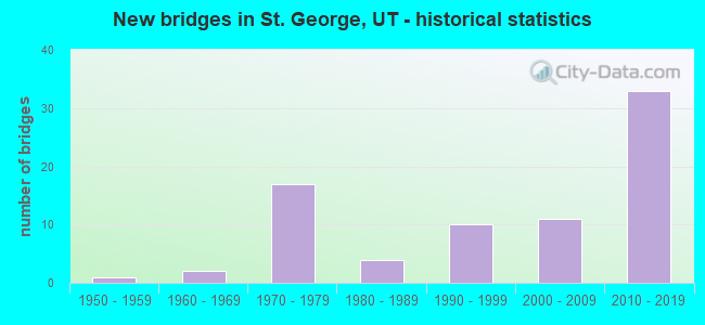
- New bridges - historical statistics
- 11950-1959
- 21960-1969
- 171970-1979
- 41980-1989
- 101990-1999
- 112000-2009
- 332010-2019
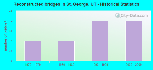
- Reconstructed bridges - Historical Statistics
- 11970-1979
- 11980-1989
- 21990-1999
- 22000-2009
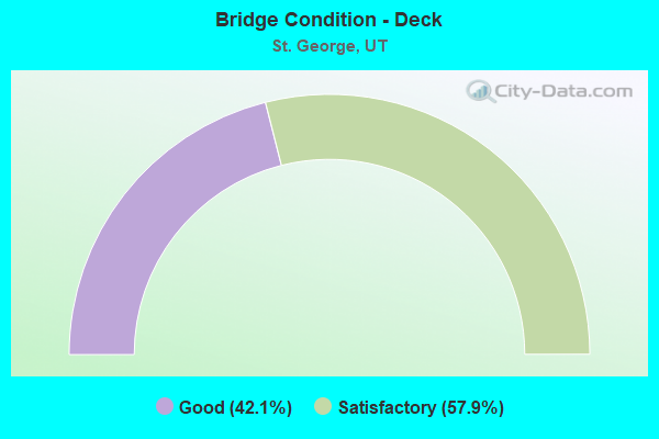
- Bridge Condition - Deck
- 42.1%Good
- 57.9%Satisfactory
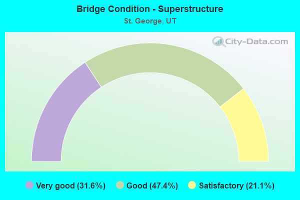
- Bridge Condition - Superstructure
- 31.6%Very good
- 47.4%Good
- 21.1%Satisfactory
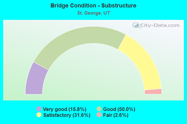
- Bridge Condition - Substructure
- 15.8%Very good
- 50.0%Good
- 31.6%Satisfactory
- 2.6%Fair
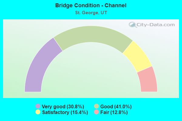
- Bridge Condition - Channel
- 30.8%Very good
- 41.0%Good
- 15.4%Satisfactory
- 12.8%Fair
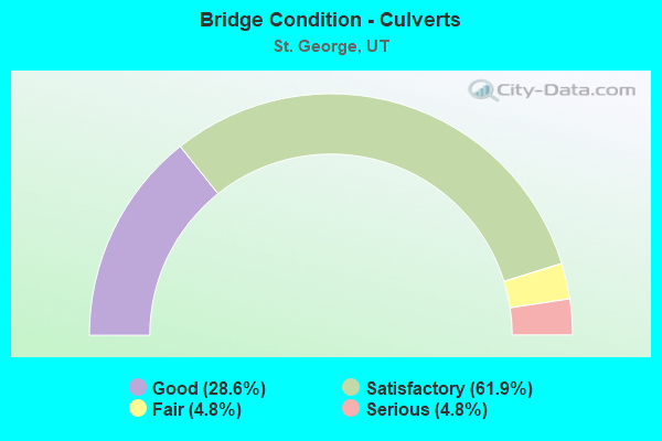
- Bridge Condition - Culverts
- 28.6%Good
- 61.9%Satisfactory
- 4.8%Fair
- 4.8%Serious
Find on map >> Show street view
Structure Number: 1F 289, Location: 1150 E.100 S.IN ST.GEORGE (Lat: 37.106222, Lng: -113.559208), Route carried "on" structure: Interstate 15, Year Built: 1972, Year Reconstructed: 1990, Status: Open, Structure Length: 3.00m (9.84ft), Average Daily Traffic: 44,537 (year 2020), Truck Traffic: 30%, Average Future Daily Traffic: 55,671 (year 2040), Design Load: HS 20+Mod, Features Intersected: 100 SOUTH STREET
Minimum Vertical Clearance: 30+ m (98+ ft), Kilometerpoint: 13.559, Lanes on structure: 3, Lanes under structure: 4, Base Highway Network: Yes, Owner: State Highway Agency, Approaching Roadway Width: 16.3m (53.5ft), Skew: 1 degrees, Material/Design: Prestressed concrete, Design/Construction: Stringer/Multi-beam, Number Of Spans In Main Unit: 1, Length of Maximum Span: 28.7m (94.2ft), Curb-To-Curb Width: 16.3m (53.5ft), Out-to-Out Width: 17.2m (56.4ft)
Condition: Deck: Good, Superstructure: Satisfactory, Substructure: Satisfactory, Operating Rating: 33.4 metric tons, Method Used To Determine Operating Rating: Load and Resistance Factor Rating (LRFR) rating reported by rating factor(RF) method using HL-93 loadings, Inventory Rating: 23.7 metric tons, Method Used To Determine Inventory Rating: Load and Resistance Factor Rating (LRFR) rating reported by rating factor(RF) method using HL-93 loadings, Structural Evaluation: Somewhat better than minimum adequacy, Deck Geometry: Equal to present minimum criteria, Underclear: Meets minimum limits, Approach Roadway Alignment: Equal to present desirable criteria, Designated Inspection Frequency: Every 24 months, Inspection Date: January 2021, Deck Structure Type: Concrete Cast-file-Place, Wearing Surface/Protective System: Wearing Surface: Bituminous, Membrane: Preformed Fabric
Find on map >> Show street view
Structure Number: 1F 291, Location: BLOOMINGTON INTERCHANGE (Lat: 37.059547, Lng: -113.584211), Route carried "on" structure: Interstate 15, Year Built: 1972, Status: Open, Structure Length: 3.18m (10.43ft), Average Daily Traffic: 55,227 (year 2020), Truck Traffic: 27%, Average Future Daily Traffic: 69,034 (year 2040), Design Load: HS 20+Mod, Features Intersected: CO. RD. TO BLOOMINGTON
Minimum Vertical Clearance: 30+ m (98+ ft), Kilometerpoint: 7.493, Lanes on structure: 2, Lanes under structure: 3, Base Highway Network: Yes, Owner: State Highway Agency, Approaching Roadway Width: 11.6m (38.1ft), Material/Design: Prestressed concrete, Design/Construction: Stringer/Multi-beam, Number Of Spans In Main Unit: 1, Length of Maximum Span: 31.1m (102.0ft), Curb-To-Curb Width: 12.3m (40.4ft), Out-to-Out Width: 13.5m (44.3ft)
Condition: Deck: Good, Superstructure: Satisfactory, Substructure: Good, Operating Rating: 37.3 metric tons, Method Used To Determine Operating Rating: Load Factor (LF) rating reported by rating factor (RF) method using MS18 loading, Inventory Rating: 26.2 metric tons, Method Used To Determine Inventory Rating: Load Factor (LF) rating reported by rating factor (RF) method using MS18 loading, Structural Evaluation: Equal to present minimum criteria, Deck Geometry: Better than present minimum criteria, Underclear: Somewhat better than minimum adequacy, Approach Roadway Alignment: Equal to present desirable criteria, Designated Inspection Frequency: Every 24 months, Inspection Date: January 2021, Deck Structure Type: Concrete Cast-file-Place, Wearing Surface/Protective System: Wearing Surface: Bituminous, Membrane: Preformed Fabric
Find on map >> Show street view
Structure Number: 1F 756, Location: 0.3 Mi. east of I-15 Int. (Lat: 37.025194, Lng: -113.601650), Route carried "on" structure: State highway 7, Year Built: 2010, Status: Open, Structure Length: 3.98m (13.06ft), Average Daily Traffic: 3,011 (year 2020), Truck Traffic: 11%, Average Future Daily Traffic: 3,764 (year 2040), Design Load: HL 93, Features Intersected: ASTRAGALUS DRIVE
Minimum Vertical Clearance: 30+ m (98+ ft), Kilometerpoint: 0.108, Lanes on structure: 3, Lanes under structure: 5, Base Highway Network: Yes, Owner: State Highway Agency, Approaching Roadway Width: 16.6m (54.5ft), Skew: 3 degrees, Material/Design: Prestressed concrete, Design/Construction: Stringer/Multi-beam, Number Of Spans In Main Unit: 1, Length of Maximum Span: 38.7m (127.0ft), Curb-To-Curb Width: 16.6m (54.5ft), Out-to-Out Width: 17.5m (57.4ft)
Condition: Deck: Satisfactory, Superstructure: Very good, Substructure: Good, Operating Rating: 53.8 metric tons, Method Used To Determine Operating Rating: Load and Resistance Factor Rating (LRFR) rating reported by rating factor(RF) method using HL-93 loadings, Inventory Rating: 36.3 metric tons, Method Used To Determine Inventory Rating: Load and Resistance Factor Rating (LRFR) rating reported by rating factor(RF) method using HL-93 loadings, Structural Evaluation: Better than present minimum criteria, Deck Geometry: Equal to present minimum criteria, Underclear: Somewhat better than minimum adequacy, Approach Roadway Alignment: Equal to present desirable criteria, Designated Inspection Frequency: Every 23 months, Inspection Date: January 2021, Deck Structure Type: Concrete Cast-file-Place, Wearing Surface/Protective System: Wearing Surface: Integral Concrete, Deck Protection: Epoxy Coated Reinforcing
Find on map >> Show street view
Structure Number: 1F 765, Location: S. Parkway over River Rd (Lat: 37.000492, Lng: -113.560511), Route carried "on" structure: State highway 7, Year Built: 2010, Status: Open, Structure Length: 3.13m (10.27ft), Average Daily Traffic: 4,327 (year 2020), Truck Traffic: 11%, Average Future Daily Traffic: 5,409 (year 2040), Design Load: HL 93, Features Intersected: RIVER ROAD
Minimum Vertical Clearance: 30+ m (98+ ft), Kilometerpoint: 5.532, Lanes on structure: 2, Lanes under structure: 2, Base Highway Network: Yes, Owner: State Highway Agency, Approaching Roadway Width: 12.2m (40.0ft), Material/Design: Prestressed concrete, Design/Construction: Stringer/Multi-beam, Number Of Spans In Main Unit: 1, Length of Maximum Span: 30.5m (100.1ft), Curb-To-Curb Width: 12.2m (40.0ft), Out-to-Out Width: 13.1m (43.0ft)
Condition: Deck: Satisfactory, Superstructure: Very good, Substructure: Very good, Operating Rating: 45.0 metric tons, Method Used To Determine Operating Rating: Load and Resistance Factor Rating (LRFR) rating reported by rating factor(RF) method using HL-93 loadings, Inventory Rating: 44.4 metric tons, Method Used To Determine Inventory Rating: Load and Resistance Factor Rating (LRFR) rating reported by rating factor(RF) method using HL-93 loadings, Structural Evaluation: Equal to present desirable criteria, Deck Geometry: Better than present minimum criteria, Underclear: Meets minimum limits, Approach Roadway Alignment: Equal to present desirable criteria, Designated Inspection Frequency: Every 24 months, Inspection Date: January 2021, Deck Structure Type: Concrete Cast-file-Place, Wearing Surface/Protective System: Wearing Surface: Epoxy Overlay, Deck Protection: Epoxy Coated Reinforcing
Find on map >> Show street view
Structure Number: 1F 766, Location: Near St.George Airport (Lat: 37.008767, Lng: -113.513531), Route carried "on" structure: State highway 7, Year Built: 2010, Status: Open, Structure Length: 3.36m (11.02ft), Average Daily Traffic: 4,596 (year 2020), Truck Traffic: 17%, Average Future Daily Traffic: 5,745 (year 2040), Design Load: HL 93, Features Intersected: DESERT CANYON PARKWAY
Minimum Vertical Clearance: 30+ m (98+ ft), Kilometerpoint: 9.897, Lanes on structure: 2, Lanes under structure: 4, Base Highway Network: Yes, Owner: State Highway Agency, Approaching Roadway Width: 12.2m (40.0ft), Skew: 2 degrees, Material/Design: Prestressed concrete, Design/Construction: Stringer/Multi-beam, Number Of Spans In Main Unit: 1, Length of Maximum Span: 32.6m (107.0ft), Curb-To-Curb Width: 12.2m (40.0ft), Out-to-Out Width: 13.1m (43.0ft)
Condition: Deck: Satisfactory, Superstructure: Very good, Substructure: Very good, Operating Rating: 45.0 metric tons, Method Used To Determine Operating Rating: Load and Resistance Factor Rating (LRFR) rating reported by rating factor(RF) method using HL-93 loadings, Inventory Rating: 39.9 metric tons, Method Used To Determine Inventory Rating: Load and Resistance Factor Rating (LRFR) rating reported by rating factor(RF) method using HL-93 loadings, Structural Evaluation: Equal to present desirable criteria, Deck Geometry: Equal to present minimum criteria, Underclear: Meets minimum limits, Approach Roadway Alignment: Equal to present desirable criteria, Designated Inspection Frequency: Every 24 months, Inspection Date: January 2021, Deck Structure Type: Concrete Cast-file-Place, Wearing Surface/Protective System: Wearing Surface: Epoxy Overlay, Deck Protection: Epoxy Coated Reinforcing
Find on map >> Show street view
Structure Number: 1F 767, Location: Road to St.George Airport (Lat: 37.010047, Lng: -113.504311), Route carried "on" structure: State highway 7, Year Built: 2010, Status: Open, Structure Length: 12.90m (42.32ft), Average Daily Traffic: 3,067 (year 2020), Truck Traffic: 12%, Average Future Daily Traffic: 3,834 (year 2040), Design Load: HL 93, Features Intersected: FORT PIERCE WASH
Minimum Vertical Clearance: 30+ m (98+ ft), Kilometerpoint: 10.733, Lanes on structure: 2, Base Highway Network: Yes, Owner: State Highway Agency, Approaching Roadway Width: 12.2m (40.0ft), Skew: 1 degrees, Material/Design: Prestressed concrete, Design/Construction: Stringer/Multi-beam, Number Of Spans In Main Unit: 3, Length of Maximum Span: 42.9m (140.7ft), Curb-To-Curb Width: 12.2m (40.0ft), Out-to-Out Width: 13.1m (43.0ft)
Condition: Deck: Satisfactory, Superstructure: Good, Substructure: Very good, Channel: Very good, Operating Rating: 82.3 metric tons, Method Used To Determine Operating Rating: Load and Resistance Factor Rating (LRFR) rating reported by rating factor(RF) method using HL-93 loadings, Inventory Rating: 37.9 metric tons, Method Used To Determine Inventory Rating: Load and Resistance Factor Rating (LRFR) rating reported by rating factor(RF) method using HL-93 loadings, Structural Evaluation: Better than present minimum criteria, Deck Geometry: Equal to present minimum criteria, Waterway Adequacy: Equal to present desirable criteria, Approach Roadway Alignment: Equal to present desirable criteria, Designated Inspection Frequency: Every 24 months, Inspection Date: January 2021, Deck Structure Type: Concrete Cast-file-Place, Wearing Surface/Protective System: Wearing Surface: Monolithic Concrete, Deck Protection: Epoxy Coated Reinforcing
Find on map >> Show street view
Structure Number: 1F 806, Location: At Dixie Drive Interchang (Lat: 37.073742, Lng: -113.584536), Route carried "on" structure: Interstate 15, Year Built: 2012, Status: Open, Structure Length: 7.20m (23.62ft), Average Daily Traffic: 55,227 (year 2020), Truck Traffic: 27%, Average Future Daily Traffic: 69,034 (year 2040), Design Load: HL 93, Features Intersected: SANTA CLARA RIVER
Minimum Vertical Clearance: 30+ m (98+ ft), Kilometerpoint: 9.078, Lanes on structure: 4, Base Highway Network: Yes, Owner: State Highway Agency, Approaching Roadway Width: 21.9m (71.9ft), Skew: 32 degrees, Material/Design: Prestressed concrete continuous, Design/Construction: Stringer/Multi-beam, Number Of Spans In Main Unit: 3, Length of Maximum Span: 28.1m (92.2ft), Curb-To-Curb Width: 21.9m (71.9ft), Out-to-Out Width: 22.8m (74.8ft)
Condition: Deck: Good, Superstructure: Good, Substructure: Satisfactory, Channel: Very good, Operating Rating: 36.3 metric tons, Method Used To Determine Operating Rating: Load and Resistance Factor Rating (LRFR) rating reported by rating factor(RF) method using HL-93 loadings, Inventory Rating: 23.7 metric tons, Method Used To Determine Inventory Rating: Load and Resistance Factor Rating (LRFR) rating reported by rating factor(RF) method using HL-93 loadings, Structural Evaluation: Somewhat better than minimum adequacy, Deck Geometry: Better than present minimum criteria, Waterway Adequacy: Equal to present desirable criteria, Approach Roadway Alignment: Equal to present desirable criteria, Designated Inspection Frequency: Every 24 months, Inspection Date: January 2021, Deck Structure Type: Concrete Cast-file-Place, Wearing Surface/Protective System: Wearing Surface: Epoxy Overlay, Deck Protection: Epoxy Coated Reinforcing
Find on map >> Show street view
Structure Number: 1F 809, Location: At Dixie Drive Interchang (Lat: 37.073658, Lng: -113.584217), Route carried "on" structure: Ramp Interstate 15, Year Built: 2012, Status: Open, Structure Length: 7.46m (24.48ft), Average Daily Traffic: 23,546 (year 2020), Truck Traffic: 25%, Average Future Daily Traffic: 29,433 (year 2040), Design Load: HL 93, Features Intersected: SANTA CLARA RIVER
Minimum Vertical Clearance: 30+ m (98+ ft), Kilometerpoint: 0.171, Lanes on structure: 3, Owner: State Highway Agency, Approaching Roadway Width: 15.9m (52.2ft), Skew: 1 degrees, Material/Design: Prestressed concrete continuous, Design/Construction: Stringer/Multi-beam, Number Of Spans In Main Unit: 3, Length of Maximum Span: 27.5m (90.2ft), Curb-To-Curb Width: 15.9m (52.2ft), Out-to-Out Width: 16.7m (54.8ft)
Condition: Deck: Satisfactory, Superstructure: Good, Substructure: Satisfactory, Channel: Very good, Operating Rating: 68.0 metric tons, Method Used To Determine Operating Rating: Load and Resistance Factor Rating (LRFR) rating reported by rating factor(RF) method using HL-93 loadings, Inventory Rating: 44.4 metric tons, Method Used To Determine Inventory Rating: Load and Resistance Factor Rating (LRFR) rating reported by rating factor(RF) method using HL-93 loadings, Structural Evaluation: Equal to present minimum criteria, Deck Geometry: Superior to present desirable criteria, Waterway Adequacy: Equal to present desirable criteria, Approach Roadway Alignment: Equal to present desirable criteria, Designated Inspection Frequency: Every 24 months, Inspection Date: January 2021, Deck Structure Type: Concrete Cast-file-Place, Wearing Surface/Protective System: Wearing Surface: Epoxy Overlay, Deck Protection: Epoxy Coated Reinforcing
Find on map >> Show street view
Structure Number: 3F 288, Location: 850 E.700 SO.IN ST.GEORGE (Lat: 37.096497, Lng: -113.565603), Route carried "on" structure: Interstate 15, Year Built: 1972, Status: Open, Structure Length: 4.81m (15.78ft), Average Daily Traffic: 44,537 (year 2020), Truck Traffic: 30%, Average Future Daily Traffic: 55,671 (year 2040), Design Load: HS 20+Mod, Features Intersected: 700 SOUTH STREET
Minimum Vertical Clearance: 30+ m (98+ ft), Kilometerpoint: 12.412, Lanes on structure: 2, Lanes under structure: 2, Base Highway Network: Yes, Owner: State Highway Agency, Approaching Roadway Width: 11.6m (38.1ft), Skew: 14 degrees, Material/Design: Prestressed concrete, Design/Construction: Stringer/Multi-beam, Number Of Spans In Main Unit: 3, Length of Maximum Span: 22.0m (72.2ft), Curb-To-Curb Width: 12.3m (40.4ft), Out-to-Out Width: 13.8m (45.3ft)
Condition: Deck: Good, Superstructure: Good, Substructure: Satisfactory, Operating Rating: 36.9 metric tons, Method Used To Determine Operating Rating: Load and Resistance Factor Rating (LRFR) rating reported by rating factor(RF) method using HL-93 loadings, Inventory Rating: 19.4 metric tons, Method Used To Determine Inventory Rating: Load Factor (LF) rating reported by rating factor (RF) method using MS18 loading, Structural Evaluation: Meets minimum limits, Deck Geometry: Better than present minimum criteria, Underclear: Somewhat better than minimum adequacy, Approach Roadway Alignment: Equal to present desirable criteria, Designated Inspection Frequency: Every 24 months, Inspection Date: January 2021, Deck Structure Type: Concrete Cast-file-Place, Wearing Surface/Protective System: Wearing Surface: Bituminous
Find on map >> Show street view
Structure Number: 3F 289, Location: 1150 E.100 S.in ST.GEORGE (Lat: 37.106597, Lng: -113.559439), Route carried "on" structure: Interstate 15, Year Built: 1972, Status: Open, Structure Length: 3.00m (9.84ft), Average Daily Traffic: 44,537 (year 2020), Truck Traffic: 30%, Average Future Daily Traffic: 55,671 (year 2040), Design Load: HS 20+Mod, Features Intersected: 100 SOUTH STREET
Minimum Vertical Clearance: 30+ m (98+ ft), Kilometerpoint: 13.676, Lanes on structure: 3, Lanes under structure: 4, Base Highway Network: Yes, Owner: State Highway Agency, Approaching Roadway Width: 19.1m (62.7ft), Skew: 1 degrees, Material/Design: Prestressed concrete, Design/Construction: Stringer/Multi-beam, Number Of Spans In Main Unit: 1, Length of Maximum Span: 30.0m (98.4ft), Curb-To-Curb Width: 19.1m (62.7ft), Out-to-Out Width: 20.1m (65.9ft)
Condition: Deck: Satisfactory, Superstructure: Satisfactory, Substructure: Satisfactory, Operating Rating: 35.6 metric tons, Method Used To Determine Operating Rating: Load Factor (LF) rating reported by rating factor (RF) method using MS18 loading, Inventory Rating: 29.2 metric tons, Method Used To Determine Inventory Rating: Load Factor (LF) rating reported by rating factor (RF) method using MS18 loading, Structural Evaluation: Equal to present minimum criteria, Deck Geometry: Superior to present desirable criteria, Underclear: Equal to present minimum criteria, Approach Roadway Alignment: Equal to present desirable criteria, Designated Inspection Frequency: Every 24 months, Inspection Date: January 2021, Deck Structure Type: Concrete Cast-file-Place, Wearing Surface/Protective System: Wearing Surface: Bituminous, Membrane: Preformed Fabric
Find on map >> Show street view
Structure Number: 3F 291, Location: BLOOMINGTON INTERCHANGE (Lat: 37.059986, Lng: -113.584361), Route carried "on" structure: Interstate 15, Year Built: 1972, Status: Open, Structure Length: 3.18m (10.43ft), Average Daily Traffic: 55,227 (year 2020), Truck Traffic: 27%, Average Future Daily Traffic: 69,034 (year 2040), Design Load: HS 20+Mod, Features Intersected: INT. RD. to BLOOMINGTON
Minimum Vertical Clearance: 30+ m (98+ ft), Kilometerpoint: 7.622, Lanes on structure: 2, Lanes under structure: 3, Base Highway Network: Yes, Owner: State Highway Agency, Approaching Roadway Width: 11.6m (38.1ft), Material/Design: Prestressed concrete, Design/Construction: Stringer/Multi-beam, Number Of Spans In Main Unit: 1, Length of Maximum Span: 31.1m (102.0ft), Curb-To-Curb Width: 12.3m (40.4ft), Out-to-Out Width: 13.5m (44.3ft)
Condition: Deck: Good, Superstructure: Satisfactory, Substructure: Good, Operating Rating: 38.9 metric tons, Method Used To Determine Operating Rating: Load Factor (LF) rating reported by rating factor (RF) method using MS18 loading, Inventory Rating: 27.5 metric tons, Method Used To Determine Inventory Rating: Load Factor (LF) rating reported by rating factor (RF) method using MS18 loading, Structural Evaluation: Equal to present minimum criteria, Deck Geometry: Better than present minimum criteria, Underclear: Somewhat better than minimum adequacy, Approach Roadway Alignment: Equal to present desirable criteria, Designated Inspection Frequency: Every 24 months, Inspection Date: January 2021, Deck Structure Type: Concrete Cast-file-Place, Wearing Surface/Protective System: Wearing Surface: Bituminous, Membrane: Preformed Fabric
Find on map >> Show street view
Structure Number: 3F 315, Location: 3 MI.SO.BLOOMINGTON INT. (Lat: 37.022036, Lng: -113.609061), Route carried "on" structure: Interstate 15, Year Built: 1971, Status: Open, Structure Length: 4.85m (15.91ft), Average Daily Traffic: 23,546 (year 2020), Truck Traffic: 25%, Average Future Daily Traffic: 29,433 (year 2040), Design Load: HS 20+Mod, Features Intersected: ATKINSVILLE WASH
Minimum Vertical Clearance: 30+ m (98+ ft), Kilometerpoint: 2.810, Lanes on structure: 2, Base Highway Network: Yes, Owner: State Highway Agency, Approaching Roadway Width: 11.6m (38.1ft), Skew: 10 degrees, Material/Design: Prestressed concrete, Design/Construction: Stringer/Multi-beam, Number Of Spans In Main Unit: 2, Length of Maximum Span: 25.0m (82.0ft), Curb-To-Curb Width: 12.3m (40.4ft), Out-to-Out Width: 13.5m (44.3ft)
Condition: Deck: Good, Superstructure: Good, Substructure: Satisfactory, Channel: Fair, Operating Rating: 41.8 metric tons, Method Used To Determine Operating Rating: Load and Resistance Factor Rating (LRFR) rating reported by rating factor(RF) method using HL-93 loadings, Inventory Rating: 27.9 metric tons, Method Used To Determine Inventory Rating: Load Factor (LF) rating reported by rating factor (RF) method using MS18 loading, Structural Evaluation: Equal to present minimum criteria, Deck Geometry: Better than present minimum criteria, Waterway Adequacy: Equal to present desirable criteria, Approach Roadway Alignment: Equal to present desirable criteria, Designated Inspection Frequency: Every 24 months, Inspection Date: January 2021, Deck Structure Type: Concrete Cast-file-Place, Wearing Surface/Protective System: Wearing Surface: Bituminous, Membrane: Preformed Fabric
Find on map >> Show street view
Structure Number: 3F 756, Location: At MP. 2.0 on SR-7 (Lat: 37.025425, Lng: -113.602114), Route carried "on" structure: State highway 7, Year Built: 2010, Status: Open, Structure Length: 3.98m (13.06ft), Average Daily Traffic: 3,011 (year 2020), Truck Traffic: 11%, Average Future Daily Traffic: 3,764 (year 2040), Design Load: HL 93, Features Intersected: EAST FRONTAGE ROAD
Minimum Vertical Clearance: 30+ m (98+ ft), Kilometerpoint: 0.492, Lanes on structure: 2, Lanes under structure: 5, Base Highway Network: Yes, Owner: State Highway Agency, Approaching Roadway Width: 16.6m (54.5ft), Skew: 3 degrees, Material/Design: Prestressed concrete, Design/Construction: Stringer/Multi-beam, Number Of Spans In Main Unit: 1, Length of Maximum Span: 38.7m (127.0ft), Curb-To-Curb Width: 16.6m (54.5ft), Out-to-Out Width: 17.5m (57.4ft)
Condition: Deck: Good, Superstructure: Very good, Substructure: Good, Operating Rating: 53.8 metric tons, Method Used To Determine Operating Rating: Load and Resistance Factor Rating (LRFR) rating reported by rating factor(RF) method using HL-93 loadings, Inventory Rating: 36.3 metric tons, Method Used To Determine Inventory Rating: Load and Resistance Factor Rating (LRFR) rating reported by rating factor(RF) method using HL-93 loadings, Structural Evaluation: Better than present minimum criteria, Deck Geometry: Superior to present desirable criteria, Underclear: Somewhat better than minimum adequacy, Approach Roadway Alignment: Equal to present desirable criteria, Designated Inspection Frequency: Every 23 months, Inspection Date: Febuary 2021, Deck Structure Type: Concrete Cast-file-Place, Wearing Surface/Protective System: Wearing Surface: Monolithic Concrete, Deck Protection: Epoxy Coated Reinforcing
Find on map >> Show street view
Structure Number: 3F 765, Location: SR-7, over River Road (Lat: 37.000778, Lng: -113.559994), Route carried "on" structure: US 7, Year Built: 2010, Status: Open, Structure Length: 3.13m (10.27ft), Average Daily Traffic: 4,327 (year 2020), Truck Traffic: 11%, Average Future Daily Traffic: 5,409 (year 2040), Design Load: HL 93, Features Intersected: RIVER ROAD
Minimum Vertical Clearance: 30+ m (98+ ft), Kilometerpoint: 5.119, Lanes on structure: 2, Lanes under structure: 2, Base Highway Network: Yes, Owner: State Highway Agency, Approaching Roadway Width: 12.2m (40.0ft), Material/Design: Prestressed concrete, Design/Construction: Stringer/Multi-beam, Number Of Spans In Main Unit: 1, Length of Maximum Span: 30.5m (100.1ft), Curb-To-Curb Width: 12.2m (40.0ft), Out-to-Out Width: 13.1m (43.0ft)
Condition: Deck: Satisfactory, Superstructure: Very good, Substructure: Good, Operating Rating: 45.0 metric tons, Method Used To Determine Operating Rating: Load and Resistance Factor Rating (LRFR) rating reported by rating factor(RF) method using HL-93 loadings, Inventory Rating: 44.4 metric tons, Method Used To Determine Inventory Rating: Load and Resistance Factor Rating (LRFR) rating reported by rating factor(RF) method using HL-93 loadings, Structural Evaluation: Better than present minimum criteria, Deck Geometry: Better than present minimum criteria, Underclear: Meets minimum limits, Approach Roadway Alignment: Equal to present desirable criteria, Designated Inspection Frequency: Every 24 months, Inspection Date: January 2021, Deck Structure Type: Concrete Cast-file-Place, Wearing Surface/Protective System: Wearing Surface: Epoxy Overlay, Deck Protection: Epoxy Coated Reinforcing
Find on map >> Show street view
Structure Number: 3F 806, Location: At Dixie Drive Interchang (Lat: 37.074611, Lng: -113.584875), Route carried "on" structure: Interstate 15, Year Built: 2012, Status: Open, Structure Length: 7.20m (23.62ft), Average Daily Traffic: 55,227 (year 2020), Truck Traffic: 29%, Average Future Daily Traffic: 69,034 (year 2040), Design Load: HL 93, Features Intersected: SANTA CLARA RIVER
Minimum Vertical Clearance: 30+ m (98+ ft), Kilometerpoint: 9.253, Lanes on structure: 4, Base Highway Network: Yes, Owner: State Highway Agency, Approaching Roadway Width: 22.0m (72.2ft), Skew: 2 degrees, Material/Design: Prestressed concrete continuous, Design/Construction: Stringer/Multi-beam, Number Of Spans In Main Unit: 3, Length of Maximum Span: 28.1m (92.2ft), Curb-To-Curb Width: 22.0m (72.2ft), Out-to-Out Width: 22.8m (74.8ft)
Condition: Deck: Good, Superstructure: Good, Substructure: Good, Channel: Very good, Operating Rating: 36.3 metric tons, Method Used To Determine Operating Rating: Load and Resistance Factor Rating (LRFR) rating reported by rating factor(RF) method using HL-93 loadings, Inventory Rating: 23.7 metric tons, Method Used To Determine Inventory Rating: Load and Resistance Factor Rating (LRFR) rating reported by rating factor(RF) method using HL-93 loadings, Structural Evaluation: Somewhat better than minimum adequacy, Deck Geometry: Better than present minimum criteria, Waterway Adequacy: Equal to present desirable criteria, Approach Roadway Alignment: Equal to present desirable criteria, Designated Inspection Frequency: Every 24 months, Inspection Date: January 2021, Deck Structure Type: Concrete Cast-file-Place, Wearing Surface/Protective System: Wearing Surface: Epoxy Overlay, Deck Protection: Epoxy Coated Reinforcing
Find on map >> Show street view
Structure Number: 3F 807, Location: At Dixie Drive Intchg. (Lat: 37.074856, Lng: -113.585392), Route carried "on" structure: Ramp Interstate 15, Year Built: 2012, Status: Open, Structure Length: 9.25m (30.35ft), Average Daily Traffic: 23,546 (year 2020), Truck Traffic: 25%, Average Future Daily Traffic: 29,433 (year 2040), Design Load: HL 93, Features Intersected: SANTA CLARA RIVER
Minimum Vertical Clearance: 30+ m (98+ ft), Kilometerpoint: 0.077, Lanes on structure: 2, Owner: State Highway Agency, Approaching Roadway Width: 15.9m (52.2ft), Skew: 3 degrees, Material/Design: Prestressed concrete continuous, Design/Construction: Stringer/Multi-beam, Number Of Spans In Main Unit: 3, Length of Maximum Span: 34.8m (114.2ft), Curb-To-Curb Width: 15.9m (52.2ft), Out-to-Out Width: 16.8m (55.1ft)
Condition: Deck: Good, Superstructure: Good, Substructure: Good, Channel: Satisfactory, Operating Rating: 50.9 metric tons, Method Used To Determine Operating Rating: Load and Resistance Factor Rating (LRFR) rating reported by rating factor(RF) method using HL-93 loadings, Inventory Rating: 32.7 metric tons, Method Used To Determine Inventory Rating: Load and Resistance Factor Rating (LRFR) rating reported by rating factor(RF) method using HL-93 loadings, Structural Evaluation: Better than present minimum criteria, Deck Geometry: Superior to present desirable criteria, Waterway Adequacy: Equal to present minimum criteria, Approach Roadway Alignment: Equal to present desirable criteria, Designated Inspection Frequency: Every 24 months, Inspection Date: January 2021, Deck Structure Type: Concrete Cast-file-Place, Wearing Surface/Protective System: Wearing Surface: Epoxy Overlay, Deck Protection: Epoxy Coated Reinforcing
Find on map >> Show street view
Structure Number: 53079F, Location: MALL DR OVER VIRGIN RIVER (Lat: 37.097061, Lng: -113.533642), Route carried "on" structure: City street 3159, Year Built: 2014, Status: Open, Structure Length: 19.93m (65.39ft), Average Daily Traffic: 20,001 (year 2020), Average Future Daily Traffic: 25,001 (year 2040), Design Load: HL 93, Features Intersected: VIRGIN RIVER, Facility Carried by Structure: MALL DRIVE
Minimum Vertical Clearance: 30+ m (98+ ft), Kilometerpoint: 2.937, Lanes on structure: 2, Owner: City or Municipal Highway Agency, Approaching Roadway Width: 9.1m (29.9ft), Material/Design: Prestressed concrete, Design/Construction: Stringer/Multi-beam, Number Of Spans In Main Unit: 5, Length of Maximum Span: 39.8m (130.6ft), Curb or Sidewalk Widths: Left: 3.0m (9.8ft), Right: 3.0m (9.8ft), Curb-To-Curb Width: 20.1m (65.9ft), Out-to-Out Width: 27.7m (90.9ft)
Condition: Deck: Satisfactory, Superstructure: Very good, Substructure: Satisfactory, Channel: Very good, Operating Rating: 54.4 metric tons, Method Used To Determine Operating Rating: Load and Resistance Factor Rating (LRFR) rating reported by rating factor(RF) method using HL-93 loadings, Inventory Rating: 36.9 metric tons, Method Used To Determine Inventory Rating: Load and Resistance Factor Rating (LRFR) rating reported by rating factor(RF) method using HL-93 loadings, Structural Evaluation: Equal to present minimum criteria, Deck Geometry: Superior to present desirable criteria, Waterway Adequacy: Better than present minimum criteria, Approach Roadway Alignment: Equal to present desirable criteria, Designated Inspection Frequency: Every 24 months, Inspection Date: Febuary 2020, Deck Structure Type: Concrete Cast-file-Place, Wearing Surface/Protective System: Wearing Surface: Monolithic Concrete, Deck Protection: Epoxy Coated Reinforcing
Find on map >> Show street view
Structure Number: 1F 847, Location: Bluff Street Interchange (Lat: 37.133672, Lng: -113.602539), Route carried "on" structure: State highway 18, Year Built: 2014, Status: Open, Structure Length: 4.35m (14.27ft), Average Daily Traffic: 8,307 (year 2020), Truck Traffic: 19%, Average Future Daily Traffic: 10,384 (year 2040), Design Load: HL 93, Features Intersected: Red Hills Parkway
Minimum Vertical Clearance: 30+ m (98+ ft), Kilometerpoint: 6.171, Lanes on structure: 2, Lanes under structure: 7, Base Highway Network: Yes, Owner: State Highway Agency, Approaching Roadway Width: 12.2m (40.0ft), Skew: 1 degrees, Material/Design: Prestressed concrete, Design/Construction: Stringer/Multi-beam, Number Of Spans In Main Unit: 1, Length of Maximum Span: 42.6m (139.8ft), Curb-To-Curb Width: 12.2m (40.0ft), Out-to-Out Width: 13.1m (43.0ft)
Condition: Deck: Satisfactory, Superstructure: Very good, Substructure: Good, Operating Rating: 81.0 metric tons, Method Used To Determine Operating Rating: Load and Resistance Factor Rating (LRFR) rating reported by rating factor(RF) method using HL-93 loadings, Inventory Rating: 34.0 metric tons, Method Used To Determine Inventory Rating: Load and Resistance Factor Rating (LRFR) rating reported by rating factor(RF) method using HL-93 loadings, Structural Evaluation: Better than present minimum criteria, Deck Geometry: Somewhat better than minimum adequacy, Underclear: Meets minimum limits, Approach Roadway Alignment: Equal to present desirable criteria, Designated Inspection Frequency: Every 24 months, Inspection Date: January 2021, Deck Structure Type: Concrete Cast-file-Place, Wearing Surface/Protective System: Wearing Surface: Epoxy Overlay, Deck Protection: Epoxy Coated Reinforcing
Find on map >> Show street view
Structure Number: 3F 848, Location: Bluff Street Interchange (Lat: 37.134106, Lng: -113.603428), Route carried "on" structure: State highway 18, Year Built: 2014, Status: Open, Structure Length: 4.01m (13.16ft), Average Daily Traffic: 30,065 (year 2020), Truck Traffic: 35%, Average Future Daily Traffic: 37,581 (year 2040), Design Load: HL 93, Features Intersected: Snow Canyon Parkway
Minimum Vertical Clearance: 30+ m (98+ ft), Kilometerpoint: 0.424, Lanes on structure: 2, Lanes under structure: 7, Base Highway Network: Yes, Owner: State Highway Agency, Approaching Roadway Width: 12.2m (40.0ft), Material/Design: Prestressed concrete, Design/Construction: Stringer/Multi-beam, Number Of Spans In Main Unit: 1, Length of Maximum Span: 39.2m (128.6ft), Curb-To-Curb Width: 12.2m (40.0ft), Out-to-Out Width: 13.1m (43.0ft)
Condition: Deck: Satisfactory, Superstructure: Very good, Substructure: Good, Operating Rating: 82.0 metric tons, Method Used To Determine Operating Rating: Load and Resistance Factor Rating (LRFR) rating reported by rating factor(RF) method using HL-93 loadings, Inventory Rating: 45.4 metric tons, Method Used To Determine Inventory Rating: Load and Resistance Factor Rating (LRFR) rating reported by rating factor(RF) method using HL-93 loadings, Structural Evaluation: Better than present minimum criteria, Deck Geometry: Better than present minimum criteria, Underclear: Superior to present desirable criteria, Approach Roadway Alignment: Equal to present desirable criteria, Designated Inspection Frequency: Every 24 months, Inspection Date: January 2021, Deck Structure Type: Concrete Cast-file-Place, Wearing Surface/Protective System: Wearing Surface: Epoxy Overlay, Deck Protection: Epoxy Coated Reinforcing
Find on map >> Show street view
Structure Number: C 588, Location: SO.ST.GEORGE INTERCHANGE (Lat: 37.083289, Lng: -113.582625), Route carried "under" structure: Interstate 15, Year Built: 1972, Structure Length: 0. m, Average Daily Traffic: 55,227 (year 2020), Truck Traffic: 29%, Features Intersected: I-15 (SR-15) & INT., Facility Carried by Structure: SR-18, INTCHG X-RD
Minimum Vertical Clearance: 4.82m (15.81ft), Kilometerpoint: 10.157, Lanes on structure: 6, Lanes under structure: 6, Material/Design: Steel continuous, Design/Construction: Stringer/Multi-beam, Length of Maximum Span: 42.2m (138.5ft)
Find on map >> Show street view
Structure Number: F 29, Location: EAST ST. GEORGE INTCHANGE (Lat: 37.109797, Lng: -113.558761), Route carried "under" structure: Interstate 15, Year Built: 1972, Structure Length: 0. m, Average Daily Traffic: 44,537 (year 2020), Truck Traffic: 30%, Features Intersected: I-15 (SR-15) NBL & S, Facility Carried by Structure: SR-34, INT.X-ROAD
Minimum Vertical Clearance: 5.18m (16.99ft), Kilometerpoint: 13.779, Lanes on structure: 5, Lanes under structure: 4, Material/Design: Prestressed concrete, Design/Construction: Stringer/Multi-beam, Length of Maximum Span: 28.0m (91.9ft)
Find on map >> Show street view
Structure Number: F 734, Location: 5 MI. NORTH OF ST.GEORGE (Lat: 37.194464, Lng: -113.622853), Route carried "under" structure: State highway 18, Year Built: 2005, Structure Length: 0. m, Average Daily Traffic: 9,364 (year 2020), Truck Traffic: 18%, Features Intersected: SR-18, Facility Carried by Structure: LEDGES INT. X-ROAD
Minimum Vertical Clearance: 5.05m (16.57ft), Kilometerpoint: 13.776, Lanes on structure: 2, Lanes under structure: 4, Material/Design: Prestressed concrete, Design/Construction: Stringer/Multi-beam, Length of Maximum Span: 31.4m (103.0ft)
Find on map >> Show street view
Structure Number: F 753, Location: At Southern Parkway Int. (Lat: 37.027903, Lng: -113.605475), Route carried "under" structure: Interstate 15, Year Built: 2010, Structure Length: 0. m, Average Daily Traffic: 23,546 (year 2020), Truck Traffic: 25%, Features Intersected: I-15, (SR-15), Facility Carried by Structure: SR-7 INTCHG.X-ROAD
Minimum Vertical Clearance: 5.21m (17.09ft), Kilometerpoint: 3.436, Lanes on structure: 6, Lanes under structure: 4, Material/Design: Prestressed concrete continuous, Design/Construction: Stringer/Multi-beam, Length of Maximum Span: 27.7m (90.9ft)
Find on map >> Show street view
Structure Number: F 808, Location: At the Dixie Drive Intchg (Lat: 37.075258, Lng: -113.585192), Route carried "under" structure: Interstate 15, Year Built: 2012, Structure Length: 0. m, Average Daily Traffic: 55,227 (year 2020), Truck Traffic: 27%, Features Intersected: I-15, (SR-15), Facility Carried by Structure: DIXIE DR. INT.X-RD
Minimum Vertical Clearance: 5.56m (18.24ft), Kilometerpoint: 9.077, Lanes on structure: 4, Lanes under structure: 6, Material/Design: Prestressed concrete continuous, Design/Construction: Stringer/Multi-beam, Length of Maximum Span: 28.1m (92.2ft)
Find on map >> Show street view
Structure Number: F 839, Location: At the Airport Interchg. (Lat: 37.014597, Lng: -113.494269), Route carried "under" structure: State highway 7, Year Built: 2010, Structure Length: 0. m, Average Daily Traffic: 3,067 (year 2020), Truck Traffic: 12%, Features Intersected: SR-7, SOUTHERN PARKWAY, Facility Carried by Structure: INTERCHG. X-ROAD.
Minimum Vertical Clearance: 5.54m (18.18ft), Kilometerpoint: 9.922, Lanes on structure: 3, Lanes under structure: 2, Material/Design: Prestressed concrete, Design/Construction: Stringer/Multi-beam, Length of Maximum Span: 24.8m (81.4ft)
Find on map >> Show street view
Structure Number: F 841, Location: Washington Dam Road (Lat: 37.114025, Lng: -113.452514), Route carried "under" structure: City street 3170, Year Built: 2013, Structure Length: 0. m, Average Daily Traffic: 1,158 (year 2020), Features Intersected: Long Valley Road, Facility Carried by Structure: SR-7; So. Parkway
Minimum Vertical Clearance: 5.33m (17.49ft), Kilometerpoint: 0.000, Lanes on structure: 2, Lanes under structure: 2, Material/Design: Prestressed concrete, Design/Construction: Stringer/Multi-beam, Length of Maximum Span: 29.9m (98.1ft)
Find on map >> Show street view
Structure Number: 1F 288, Location: 850 E 700 S in St. George (Lat: 37.096056, Lng: -113.565708), Route carried "under" structure: City street , Year Built: 1972, Structure Length: 0. m, Features Intersected: 700 S. Street, Facility Carried by Structure: I-15 (SR-15) NBL
Minimum Vertical Clearance: 5.04m (16.54ft), Kilometerpoint: 0.000, Lanes on structure: 2, Lanes under structure: 4, Material/Design: Prestressed concrete, Design/Construction: Stringer/Multi-beam, Length of Maximum Span: 22.0m (72.2ft)
Find on map >> Show street view
Structure Number: 1F 289, Location: 1150 E.100 S.IN ST.GEORGE (Lat: 37.106222, Lng: -113.559208), Route carried "under" structure: City street , Year Built: 1972, Structure Length: 0. m, Features Intersected: 100 SOUTH STREET, Facility Carried by Structure: I-15 (SR-15) NBL
Minimum Vertical Clearance: 4.90m (16.08ft), Kilometerpoint: 0.000, Lanes on structure: 3, Lanes under structure: 2, Material/Design: Prestressed concrete, Design/Construction: Stringer/Multi-beam, Length of Maximum Span: 28.7m (94.2ft)
Find on map >> Show street view
Structure Number: 1F 291, Location: BLOOMINGTON INTERCHANGE (Lat: 37.059547, Lng: -113.584211), Route carried "under" structure: City street , Year Built: 1972, Structure Length: 0. m, Features Intersected: CO. RD. TO BLOOMINGTON, Facility Carried by Structure: I-15 (SR-15) NBL
Minimum Vertical Clearance: 4.95m (16.24ft), Kilometerpoint: 0.000, Lanes on structure: 2, Lanes under structure: 3, Material/Design: Prestressed concrete, Design/Construction: Stringer/Multi-beam, Length of Maximum Span: 31.1m (102.0ft)
Find on map >> Show street view
Structure Number: 1F 756, Location: 0.3 Mi. east of I-15 Int. (Lat: 37.025194, Lng: -113.601650), Route carried "under" structure: City street , Year Built: 2010, Structure Length: 0. m, Features Intersected: ASTRAGALUS DRIVE, Facility Carried by Structure: SR-7,(SO. PARKWAY)
Minimum Vertical Clearance: 5.61m (18.41ft), Kilometerpoint: 0.000, Lanes on structure: 3, Lanes under structure: 4, Material/Design: Prestressed concrete, Design/Construction: Stringer/Multi-beam, Length of Maximum Span: 38.7m (127.0ft)
Find on map >> Show street view
Structure Number: 1F 765, Location: S. Parkway over River Rd (Lat: 37.000492, Lng: -113.560511), Route carried "under" structure: State highway 3142, Year Built: 2010, Structure Length: 0. m, Average Daily Traffic: 14,037 (year 2020), Features Intersected: RIVER ROAD, Facility Carried by Structure: SR-7 NB
Minimum Vertical Clearance: 6.12m (20.08ft), Kilometerpoint: 0.000, Lanes on structure: 2, Lanes under structure: 2, Material/Design: Prestressed concrete, Design/Construction: Stringer/Multi-beam, Length of Maximum Span: 30.5m (100.1ft)
Find on map >> Show street view
Structure Number: 1F 766, Location: Near St.George Airport (Lat: 37.008767, Lng: -113.513531), Route carried "under" structure: County highway 3149, Year Built: 2010, Structure Length: 0. m, Average Daily Traffic: 581 (year 2020), Features Intersected: DESERT CANYON PARKWAY, Facility Carried by Structure: SR-7,SOUTHERN PKW.
Minimum Vertical Clearance: 5.51m (18.08ft), Kilometerpoint: 0.000, Lanes on structure: 2, Lanes under structure: 4, Material/Design: Prestressed concrete, Design/Construction: Stringer/Multi-beam, Length of Maximum Span: 32.6m (107.0ft)
Find on map >> Show street view
Structure Number: 3F 288, Location: 850 E.700 SO.IN ST.GEORGE (Lat: 37.096497, Lng: -113.565603), Route carried "under" structure: City street , Year Built: 1972, Structure Length: 0. m, Average Daily Traffic: 25,000 (year 2020), Features Intersected: 700 SOUTH STREET, Facility Carried by Structure: I-15 (SR-15) SBL
Minimum Vertical Clearance: 5.23m (17.16ft), Kilometerpoint: 0.000, Lanes on structure: 2, Lanes under structure: 2, Material/Design: Prestressed concrete, Design/Construction: Stringer/Multi-beam, Length of Maximum Span: 22.0m (72.2ft)
Find on map >> Show street view
Structure Number: 3F 289, Location: 1150 E.100 S.in ST.GEORGE (Lat: 37.106597, Lng: -113.559439), Route carried "under" structure: City street , Year Built: 1972, Structure Length: 0. m, Features Intersected: 100 SOUTH STREET, Facility Carried by Structure: I-15 (SR-15) SBL
Minimum Vertical Clearance: 4.65m (15.26ft), Kilometerpoint: 0.000, Lanes on structure: 3, Lanes under structure: 2, Material/Design: Prestressed concrete, Design/Construction: Stringer/Multi-beam, Length of Maximum Span: 30.0m (98.4ft)
Find on map >> Show street view
Structure Number: 3F 291, Location: BLOOMINGTON INTERCHANGE (Lat: 37.059986, Lng: -113.584361), Route carried "under" structure: City street , Year Built: 1972, Structure Length: 0. m, Features Intersected: INT. RD. to BLOOMINGTON, Facility Carried by Structure: I-15 (SR-15) SBL
Minimum Vertical Clearance: 4.83m (15.85ft), Kilometerpoint: 0.000, Lanes on structure: 2, Lanes under structure: 3, Material/Design: Prestressed concrete, Design/Construction: Stringer/Multi-beam, Length of Maximum Span: 31.1m (102.0ft)
Find on map >> Show street view
Structure Number: 3F 756, Location: At MP. 2.0 on SR-7 (Lat: 37.025425, Lng: -113.602114), Route carried "under" structure: Alternate County highway , Year Built: 2010, Structure Length: 0. m, Features Intersected: EAST FRONTAGE ROAD, Facility Carried by Structure: SR-7, S. Parkway
Minimum Vertical Clearance: 5.21m (17.09ft), Kilometerpoint: 0.000, Lanes on structure: 2, Lanes under structure: 4, Material/Design: Prestressed concrete, Design/Construction: Stringer/Multi-beam, Length of Maximum Span: 38.7m (127.0ft)
Find on map >> Show street view
Structure Number: 3F 765, Location: SR-7, over River Road (Lat: 37.000778, Lng: -113.559994), Route carried "under" structure: City street 3142, Year Built: 2010, Structure Length: 0. m, Average Daily Traffic: 14,037 (year 2020), Features Intersected: RIVER ROAD, Facility Carried by Structure: SR-7,SOUTHERN PKW.
Minimum Vertical Clearance: 5.41m (17.75ft), Kilometerpoint: 0.000, Lanes on structure: 2, Lanes under structure: 2, Material/Design: Prestressed concrete, Design/Construction: Stringer/Multi-beam, Length of Maximum Span: 30.5m (100.1ft)
Find on map >> Show street view
Structure Number: 1F 847, Location: Bluff Street Interchange (Lat: 37.133672, Lng: -113.602539), Route carried "under" structure: County highway 3190, Year Built: 2014, Structure Length: 0. m, Average Daily Traffic: 6,816 (year 2020), Features Intersected: Red Hills Parkway, Facility Carried by Structure: NB Bluff St SR-18
Minimum Vertical Clearance: 5.23m (17.16ft), Kilometerpoint: 0.000, Lanes on structure: 2, Lanes under structure: 7, Material/Design: Prestressed concrete, Design/Construction: Stringer/Multi-beam, Length of Maximum Span: 42.6m (139.8ft)