Bridge Statistics for Starkville, Mississippi (MS)
Condition, Traffic, Stress, Structural Evaluation, Project Costs
- National Bridge Inventory (NBI) Statistics
- 108Number of bridges
- 1,243ft / 379mTotal length
- $5,704,416,000Total costs
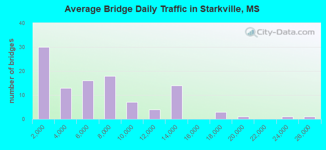
- 635,050Total average daily traffic
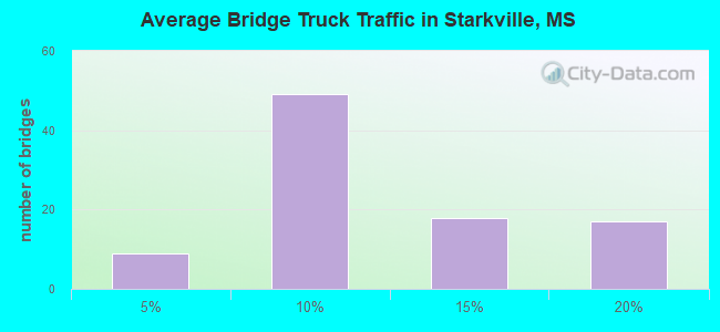
- 61,695Total average daily truck traffic
- National Bridge Inventory (NBI) Registered Bridges for Starkville
- No street view available for this location
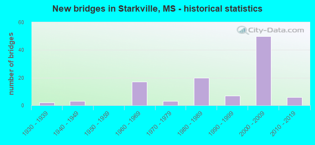
- New bridges - historical statistics
- 21930-1939
- 31940-1949
- 171960-1969
- 31970-1979
- 201980-1989
- 71990-1999
- 502000-2009
- 62010-2019
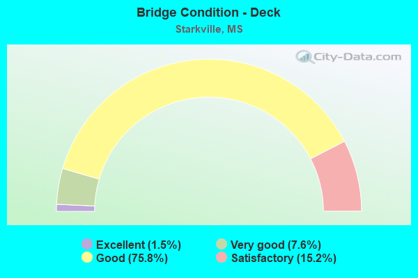
- Bridge Condition - Deck
- 1.5%Excellent
- 7.6%Very good
- 75.8%Good
- 15.2%Satisfactory
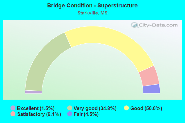
- Bridge Condition - Superstructure
- 1.5%Excellent
- 34.8%Very good
- 50.0%Good
- 9.1%Satisfactory
- 4.5%Fair
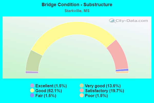
- Bridge Condition - Substructure
- 1.5%Excellent
- 13.6%Very good
- 62.1%Good
- 19.7%Satisfactory
- 1.5%Fair
- 1.5%Poor
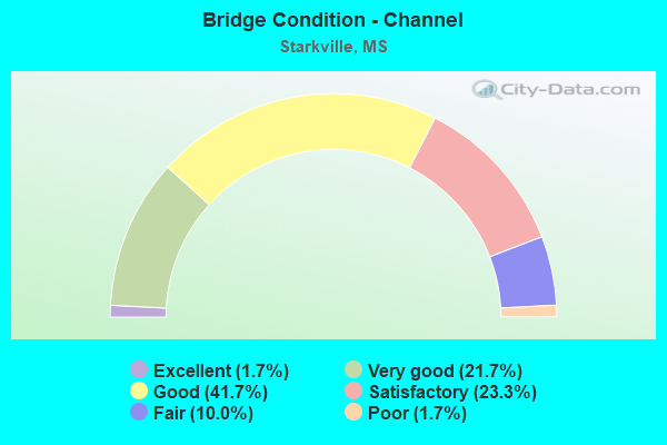
- Bridge Condition - Channel
- 1.7%Excellent
- 21.7%Very good
- 41.7%Good
- 23.3%Satisfactory
- 10.0%Fair
- 1.7%Poor
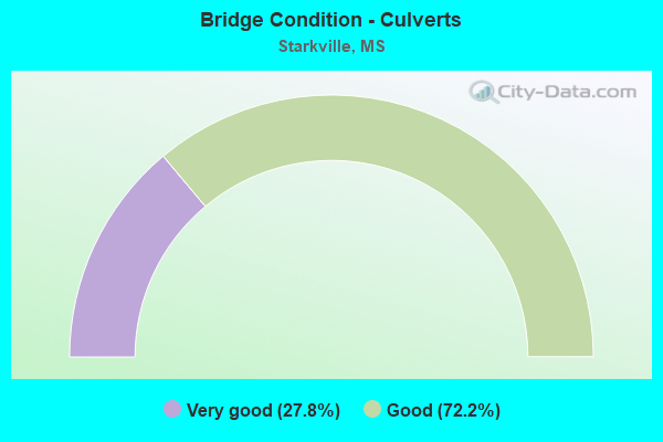
- Bridge Condition - Culverts
- 27.8%Very good
- 72.2%Good
Find on map >> Show street view
Structure Number: SA530000000A09, Location: SEC 29 T18N R14E B (Lat: 33.403031, Lng: -88.860703), Route carried "on" structure: County highway 27140, Year Built: 2016, Status: Open, Structure Length: 2.10m (6.89ft), Average Daily Traffic: 150 (year 2012), Average Future Daily Traffic: 225 (year 2032), Design Load: HS 20, Features Intersected: BCH OF TOBACCO CREEK, Facility Carried by Structure: LONG VIEW ROAD
Minimum Vertical Clearance: 30+ m (98+ ft), Kilometerpoint: 5600.000, Lanes on structure: 2, Owner: County Highway Agency, Approaching Roadway Width: 76.0m (249.3ft), Material/Design: Concrete, Design/Construction: Channel Beam, Number Of Spans In Main Unit: 3, Length of Maximum Span: 9.4m (30.8ft), Curb or Sidewalk Widths: Left: 2.0m (6.6ft), Right: 2.0m (6.6ft), Curb-To-Curb Width: 91.0m (298.6ft), Out-to-Out Width: 95.0m (311.7ft)
Condition: Deck: Very good, Superstructure: Very good, Substructure: Very good, Channel: Very good, Operating Rating: 50.5 metric tons, Method Used To Determine Operating Rating: Load and Resistance Factor Rating (LRFR) rating reported by rating factor(RF) method using HL-93 loadings, Inventory Rating: 38.9 metric tons, Method Used To Determine Inventory Rating: Load and Resistance Factor Rating (LRFR) rating reported by rating factor(RF) method using HL-93 loadings, Structural Evaluation: Equal to present desirable criteria, Deck Geometry: Superior to present desirable criteria, Waterway Adequacy: Equal to present desirable criteria, Approach Roadway Alignment: Equal to present desirable criteria, Designated Inspection Frequency: Every 24 months, Inspection Date: March 2021, Deck Structure Type: Concrete Precast Panels, Wearing Surface/Protective System: Wearing Surface: Monolithic Concrete
Find on map >> Show street view
Structure Number: SA530000000A127, Location: SEC 25 T19N R13E (Lat: 33.484908, Lng: -88.886331), Route carried "on" structure: County highway 174, Year Built: 2017, Status: Open, Structure Length: 5.48m (17.98ft), Average Daily Traffic: 150 (year 2013), Truck Traffic: 8%, Average Future Daily Traffic: 225 (year 2035), Design Load: HS 20, Features Intersected: TRIM CANE CREEK, Facility Carried by Structure: REED ROAD
Minimum Vertical Clearance: 30+ m (98+ ft), Kilometerpoint: 4.828, Lanes on structure: 2, Owner: County Highway Agency, Approaching Roadway Width: 79.0m (259.2ft), Material/Design: Prestressed concrete, Design/Construction: Stringer/Multi-beam, Number Of Spans In Main Unit: 1, Number Of Approach Spans: 2, Length of Maximum Span: 30.0m (98.4ft), Curb or Sidewalk Widths: Left: 0.2m (0.7ft), Right: 0.2m (0.7ft), Curb-To-Curb Width: 85.0m (278.9ft), Out-to-Out Width: 94.0m (308.4ft)
Condition: Deck: Excellent, Superstructure: Excellent, Substructure: Excellent, Channel: Excellent, Operating Rating: 50.5 metric tons, Method Used To Determine Operating Rating: Load and Resistance Factor Rating (LRFR) rating reported by rating factor(RF) method using HL-93 loadings, Inventory Rating: 38.9 metric tons, Method Used To Determine Inventory Rating: Load and Resistance Factor Rating (LRFR) rating reported by rating factor(RF) method using HL-93 loadings, Structural Evaluation: Superior to present desirable criteria, Deck Geometry: Superior to present desirable criteria, Waterway Adequacy: Equal to present desirable criteria, Approach Roadway Alignment: Equal to present desirable criteria, Designated Inspection Frequency: Every 24 months, Inspection Date: January 2020, Deck Structure Type: Concrete Cast-file-Place, Wearing Surface/Protective System: Wearing Surface: Monolithic Concrete
Find on map >> Show street view
Structure Number: 31000120531568A, Location: SR 12 OVER SR 182 (Lat: 33.467031, Lng: -88.797500), Route carried "under" structure: State highway 182, Year Built: 1962, Structure Length: 0. m, Average Daily Traffic: 13,500 (year 2017), Truck Traffic: 8%, Features Intersected: SR 182, Facility Carried by Structure: SR 12
Minimum Vertical Clearance: 4.79m (15.72ft), Kilometerpoint: 3.941, Lanes on structure: 2, Lanes under structure: 4, Material/Design: Concrete continuous, Design/Construction: Box Beam or Girders - Single/Spread, Length of Maximum Span: 19.8m (65.0ft)
Find on map >> Show street view
Structure Number: 31000120531568A, Location: SR 12 OVER SR 182 (Lat: 33.466861, Lng: -88.797469), Route carried "under" structure: State highway 182, Year Built: 1962, Structure Length: 0. m, Average Daily Traffic: 13,500 (year 2017), Truck Traffic: 8%, Features Intersected: SR 182, Facility Carried by Structure: SR 12
Minimum Vertical Clearance: 4.91m (16.11ft), Kilometerpoint: 16.386, Lanes on structure: 2, Lanes under structure: 4, Material/Design: Concrete continuous, Design/Construction: Box Beam or Girders - Single/Spread, Length of Maximum Span: 19.8m (65.0ft)
Find on map >> Show street view
Structure Number: 31000120531568B, Location: SR 12 OVER SR 182 (Lat: 33.467061, Lng: -88.797289), Route carried "under" structure: State highway 182, Year Built: 1962, Structure Length: 0. m, Average Daily Traffic: 5,500 (year 2017), Truck Traffic: 8%, Features Intersected: SR 182, Facility Carried by Structure: SR 12
Minimum Vertical Clearance: 4.54m (14.90ft), Kilometerpoint: 3.922, Lanes on structure: 2, Lanes under structure: 4, Material/Design: Concrete continuous, Design/Construction: Box Beam or Girders - Single/Spread, Length of Maximum Span: 19.8m (65.0ft)
Find on map >> Show street view
Structure Number: 31000120531568B, Location: SR 12 OVER SR 182 (Lat: 33.466881, Lng: -88.797261), Route carried "under" structure: State highway 182, Year Built: 1962, Structure Length: 0. m, Average Daily Traffic: 5,500 (year 2017), Truck Traffic: 8%, Features Intersected: SR 182, Facility Carried by Structure: SR 12
Minimum Vertical Clearance: 4.66m (15.29ft), Kilometerpoint: 16.407, Lanes on structure: 2, Lanes under structure: 4, Material/Design: Concrete continuous, Design/Construction: Box Beam or Girders - Single/Spread, Length of Maximum Span: 19.8m (65.0ft)
Find on map >> Show street view
Structure Number: 31000120531585A, Location: SR 12 OVER US 82 (Lat: 33.488461, Lng: -88.787231), Route carried "under" structure: US 82, Year Built: 2004, Structure Length: 0. m, Average Daily Traffic: 16,000 (year 2017), Truck Traffic: 8%, Features Intersected: US 82, Facility Carried by Structure: SR 12
Minimum Vertical Clearance: 5.61m (18.41ft), Kilometerpoint: 28.986, Lanes on structure: 2, Lanes under structure: 5, Material/Design: Prestressed concrete continuous, Design/Construction: Stringer/Multi-beam, Length of Maximum Span: 30.5m (100.1ft)
Find on map >> Show street view
Structure Number: 31000120531585A, Location: SR 12 OVER US 82 (Lat: 33.488631, Lng: -88.787019), Route carried "under" structure: US 82, Year Built: 2004, Structure Length: 0. m, Average Daily Traffic: 16,000 (year 2017), Truck Traffic: 8%, Features Intersected: US 82, Facility Carried by Structure: SR 12
Minimum Vertical Clearance: 6.10m (20.01ft), Kilometerpoint: 12.262, Lanes on structure: 2, Lanes under structure: 5, Material/Design: Prestressed concrete continuous, Design/Construction: Stringer/Multi-beam, Length of Maximum Span: 30.5m (100.1ft)
Find on map >> Show street view
Structure Number: 31000120531585B, Location: SR 12 OVER US 82 (Lat: 33.488281, Lng: -88.787011), Route carried "under" structure: US 82, Year Built: 2004, Structure Length: 0. m, Average Daily Traffic: 8,500 (year 2017), Truck Traffic: 8%, Features Intersected: US 82, Facility Carried by Structure: SR 12
Minimum Vertical Clearance: 5.52m (18.11ft), Kilometerpoint: 29.015, Lanes on structure: 2, Lanes under structure: 5, Material/Design: Prestressed concrete continuous, Design/Construction: Stringer/Multi-beam, Length of Maximum Span: 30.5m (100.1ft)
Find on map >> Show street view
Structure Number: 31000120531585B, Location: SR 12 OVER US 82 (Lat: 33.488461, Lng: -88.786811), Route carried "under" structure: US 82, Year Built: 2004, Structure Length: 0. m, Average Daily Traffic: 8,500 (year 2017), Truck Traffic: 8%, Features Intersected: US 82, Facility Carried by Structure: SR 12
Minimum Vertical Clearance: 6.04m (19.82ft), Kilometerpoint: 12.234, Lanes on structure: 2, Lanes under structure: 5, Material/Design: Prestressed concrete continuous, Design/Construction: Stringer/Multi-beam, Length of Maximum Span: 30.5m (100.1ft)
Find on map >> Show street view
Structure Number: 31000250530668A, Location: SR 25 OVER SR 12 (Lat: 33.440761, Lng: -88.853989), Route carried "under" structure: State highway 12, Year Built: 2003, Structure Length: 0. m, Average Daily Traffic: 22,000 (year 2017), Truck Traffic: 8%, Features Intersected: SR 12/KCS RR, Facility Carried by Structure: SR 25
Minimum Vertical Clearance: 5.52m (18.11ft), Kilometerpoint: 25.753, Lanes on structure: 2, Lanes under structure: 6, Material/Design: Prestressed concrete, Design/Construction: Stringer/Multi-beam, Length of Maximum Span: 45.1m (148.0ft)
Find on map >> Show street view
Structure Number: 31000250530668B, Location: SR 25 OVER SR 12 (Lat: 33.440919, Lng: -88.853689), Route carried "under" structure: State highway 12, Year Built: 2003, Structure Length: 0. m, Average Daily Traffic: 18,500 (year 2017), Truck Traffic: 8%, Features Intersected: SR 12/KCS RR, Facility Carried by Structure: SR 25
Minimum Vertical Clearance: 5.24m (17.19ft), Kilometerpoint: 25.785, Lanes on structure: 3, Lanes under structure: 6, Material/Design: Prestressed concrete, Design/Construction: Stringer/Multi-beam, Length of Maximum Span: 45.1m (148.0ft)
Find on map >> Show street view
Structure Number: 31000250530705A, Location: SR 25 OVER US 82 (Lat: 33.495469, Lng: -88.849981), Route carried "under" structure: US 82, Year Built: 2004, Structure Length: 0. m, Average Daily Traffic: 7,000 (year 2017), Truck Traffic: 10%, Features Intersected: US 82, Facility Carried by Structure: SR 25
Minimum Vertical Clearance: 5.76m (18.90ft), Kilometerpoint: 18.340, Lanes on structure: 2, Lanes under structure: 5, Material/Design: Prestressed concrete continuous, Design/Construction: Stringer/Multi-beam, Length of Maximum Span: 30.8m (101.0ft)
Find on map >> Show street view
Structure Number: 31000250530705A, Location: SR 25 OVER US 82 (Lat: 33.495231, Lng: -88.850000), Route carried "under" structure: US 82, Year Built: 2004, Structure Length: 0. m, Average Daily Traffic: 7,000 (year 2017), Truck Traffic: 10%, Features Intersected: US 82, Facility Carried by Structure: SR 25
Minimum Vertical Clearance: 5.58m (18.31ft), Kilometerpoint: 22.923, Lanes on structure: 2, Lanes under structure: 5, Material/Design: Prestressed concrete continuous, Design/Construction: Stringer/Multi-beam, Length of Maximum Span: 30.8m (101.0ft)
Find on map >> Show street view
Structure Number: 31000250530705B, Location: SR 25 OVER US 82 (Lat: 33.495469, Lng: -88.849700), Route carried "under" structure: US 82, Year Built: 2004, Structure Length: 0. m, Average Daily Traffic: 7,000 (year 2017), Truck Traffic: 10%, Features Intersected: US 82, Facility Carried by Structure: SR 25
Minimum Vertical Clearance: 5.61m (18.41ft), Kilometerpoint: 18.313, Lanes on structure: 1, Lanes under structure: 5, Material/Design: Prestressed concrete continuous, Design/Construction: Stringer/Multi-beam, Length of Maximum Span: 30.8m (101.0ft)
Find on map >> Show street view
Structure Number: 31000250530705B, Location: SR 25 OVER US 82 (Lat: 33.495231, Lng: -88.849719), Route carried "under" structure: US 82, Year Built: 2004, Structure Length: 0. m, Average Daily Traffic: 7,000 (year 2017), Truck Traffic: 10%, Features Intersected: US 82, Facility Carried by Structure: SR 25
Minimum Vertical Clearance: 5.36m (17.59ft), Kilometerpoint: 22.951, Lanes on structure: 1, Lanes under structure: 5, Material/Design: Prestressed concrete continuous, Design/Construction: Stringer/Multi-beam, Length of Maximum Span: 30.8m (101.0ft)
Find on map >> Show street view
Structure Number: 31001820531471, Location: 5.4 MI W JCT US82 & SR182 (Lat: 33.462000, Lng: -88.853111), Route carried "under" structure: State highway 25, Year Built: 2000, Structure Length: 0. m, Average Daily Traffic: 12,500 (year 2017), Truck Traffic: 10%, Features Intersected: SR 25, Facility Carried by Structure: SR 182
Minimum Vertical Clearance: 4.88m (16.01ft), Kilometerpoint: 3.766, Lanes on structure: 4, Lanes under structure: 4, Material/Design: Prestressed concrete continuous, Design/Construction: Stringer/Multi-beam, Length of Maximum Span: 43.6m (143.0ft)
Find on map >> Show street view
Structure Number: 31001820531471, Location: 5.4 MI W JCT US82 & SR182 (Lat: 33.462000, Lng: -88.852831), Route carried "under" structure: State highway 25, Year Built: 2000, Structure Length: 0. m, Average Daily Traffic: 12,500 (year 2017), Truck Traffic: 10%, Features Intersected: SR 25, Facility Carried by Structure: SR 182
Minimum Vertical Clearance: 5.18m (16.99ft), Kilometerpoint: 21.147, Lanes on structure: 4, Lanes under structure: 4, Material/Design: Prestressed concrete continuous, Design/Construction: Stringer/Multi-beam, Length of Maximum Span: 43.6m (143.0ft)
Find on map >> Show street view
Structure Number: 31003890530022, Location: SR 389 OVER US 82 (Lat: 33.495581, Lng: -88.824781), Route carried "under" structure: US 82, Year Built: 2001, Structure Length: 0. m, Average Daily Traffic: 7,000 (year 2017), Truck Traffic: 10%, Features Intersected: US 82, Facility Carried by Structure: SR 389
Minimum Vertical Clearance: 5.49m (18.01ft), Kilometerpoint: 15.997, Lanes on structure: 3, Lanes under structure: 4, Material/Design: Prestressed concrete, Design/Construction: Stringer/Multi-beam, Length of Maximum Span: 32.9m (107.9ft)
Find on map >> Show street view
Structure Number: 31003890530022, Location: SR 389 OVER US 82 (Lat: 33.495331, Lng: -88.824569), Route carried "under" structure: US 82, Year Built: 2001, Structure Length: 0. m, Average Daily Traffic: 7,000 (year 2017), Truck Traffic: 10%, Features Intersected: US 82, Facility Carried by Structure: SR 389
Minimum Vertical Clearance: 5.55m (18.21ft), Kilometerpoint: 25.288, Lanes on structure: 3, Lanes under structure: 4, Material/Design: Prestressed concrete, Design/Construction: Stringer/Multi-beam, Length of Maximum Span: 32.9m (107.9ft)
Find on map >> Show street view
Structure Number: 41000120531562, Location: 0.6 MI S US 82 (Lat: 33.458661, Lng: -88.798719), Route carried "under" structure: State highway 12, Year Built: 1962, Structure Length: 0. m, Average Daily Traffic: 12,000 (year 2017), Truck Traffic: 8%, Features Intersected: SR 12, Facility Carried by Structure: UNIVERSITY DRIVE
Minimum Vertical Clearance: 4.60m (15.09ft), Kilometerpoint: 3.730, Lanes on structure: 2, Lanes under structure: 4, Material/Design: Concrete continuous, Design/Construction: Box Beam or Girders - Single/Spread, Length of Maximum Span: 19.8m (65.0ft)
Find on map >> Show street view
Structure Number: 41000120531562, Location: 0.6 MI S US 82 (Lat: 33.458539, Lng: -88.798569), Route carried "under" structure: State highway 12, Year Built: 1962, Structure Length: 0. m, Average Daily Traffic: 12,000 (year 2017), Truck Traffic: 8%, Features Intersected: SR 12, Facility Carried by Structure: UNIVERSITY DRIVE
Minimum Vertical Clearance: 4.69m (15.39ft), Kilometerpoint: 31.599, Lanes on structure: 2, Lanes under structure: 4, Material/Design: Concrete continuous, Design/Construction: Box Beam or Girders - Single/Spread, Length of Maximum Span: 19.8m (65.0ft)
Find on map >> Show street view
Structure Number: 41000820531492, Location: 0.8 MI E SR 389 (Lat: 33.495639, Lng: -88.810311), Route carried "under" structure: US 82, Year Built: 2004, Structure Length: 0. m, Average Daily Traffic: 6,500 (year 2017), Truck Traffic: 10%, Features Intersected: US 82, Facility Carried by Structure: ROCKHILL ROAD
Minimum Vertical Clearance: 5.55m (18.21ft), Kilometerpoint: 14.653, Lanes on structure: 2, Lanes under structure: 4, Material/Design: Prestressed concrete continuous, Design/Construction: Stringer/Multi-beam, Length of Maximum Span: 26.8m (87.9ft)
Find on map >> Show street view
Structure Number: 41000820531492, Location: 0.8 MI E SR 389 (Lat: 33.495389, Lng: -88.810311), Route carried "under" structure: US 82, Year Built: 2004, Structure Length: 0. m, Average Daily Traffic: 6,500 (year 2017), Truck Traffic: 10%, Features Intersected: US 82, Facility Carried by Structure: ROCKHILL ROAD
Minimum Vertical Clearance: 5.64m (18.50ft), Kilometerpoint: 26.615, Lanes on structure: 2, Lanes under structure: 4, Material/Design: Prestressed concrete continuous, Design/Construction: Stringer/Multi-beam, Length of Maximum Span: 26.8m (87.9ft)
Find on map >> Show street view
Structure Number: 51000120531561, Location: 0.7 MI S SR 182 (Lat: 33.458511, Lng: -88.798839), Route carried "under" structure: State highway 12, Year Built: 2000, Structure Length: 0. m, Average Daily Traffic: 12,000 (year 2017), Truck Traffic: 8%, Features Intersected: SR 12, Facility Carried by Structure: PEDESTRIAN WALKWAY
Minimum Vertical Clearance: 5.21m (17.09ft), Kilometerpoint: 3.751, Lanes under structure: 4, Material/Design: Wood or Timber, Design/Construction: Stringer/Multi-beam, Length of Maximum Span: 30.5m (100.1ft)
Find on map >> Show street view
Structure Number: 51000120531561, Location: 0.7 MI S SR 182 (Lat: 33.458389, Lng: -88.798689), Route carried "under" structure: State highway 12, Year Built: 2000, Structure Length: 0. m, Average Daily Traffic: 12,000 (year 2017), Truck Traffic: 8%, Features Intersected: SR 12, Facility Carried by Structure: PEDESTRIAN WALKWAY
Minimum Vertical Clearance: 5.09m (16.70ft), Kilometerpoint: 31.580, Lanes under structure: 4, Material/Design: Wood or Timber, Design/Construction: Stringer/Multi-beam, Length of Maximum Span: 30.5m (100.1ft)