Bridge Statistics for Sterling Heights, Michigan (MI)
Condition, Traffic, Stress, Structural Evaluation, Project Costs
- National Bridge Inventory (NBI) Statistics
- 82Number of bridges
- 715ft / 218mTotal length
- $969,000Total costs
- 2,831,203Total average daily traffic
- 90,272Total average daily truck traffic
- National Bridge Inventory (NBI) Registered Bridges for Sterling Heights
- No street view available for this location
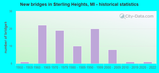
- New bridges - historical statistics
- 11950-1959
- 221960-1969
- 191970-1979
- 101980-1989
- 201990-1999
- 82000-2009
- 12010-2019
- 12020-2022
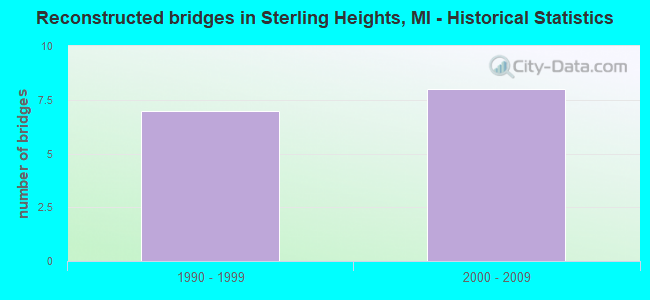
- Reconstructed bridges - Historical Statistics
- 71990-1999
- 82000-2009
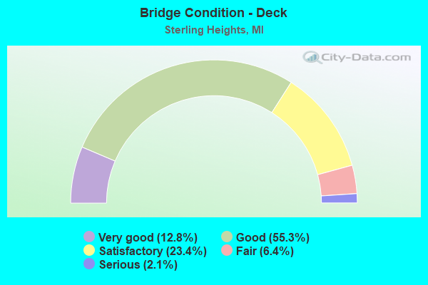
- Bridge Condition - Deck
- 12.8%Very good
- 55.3%Good
- 23.4%Satisfactory
- 6.4%Fair
- 2.1%Serious
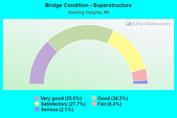
- Bridge Condition - Superstructure
- 25.5%Very good
- 38.3%Good
- 27.7%Satisfactory
- 6.4%Fair
- 2.1%Serious
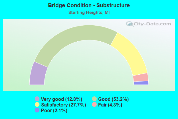
- Bridge Condition - Substructure
- 12.8%Very good
- 53.2%Good
- 27.7%Satisfactory
- 4.3%Fair
- 2.1%Poor
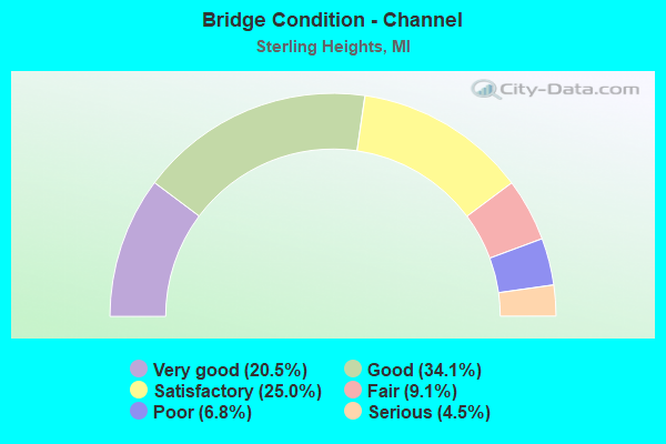
- Bridge Condition - Channel
- 20.5%Very good
- 34.1%Good
- 25.0%Satisfactory
- 9.1%Fair
- 6.8%Poor
- 4.5%Serious
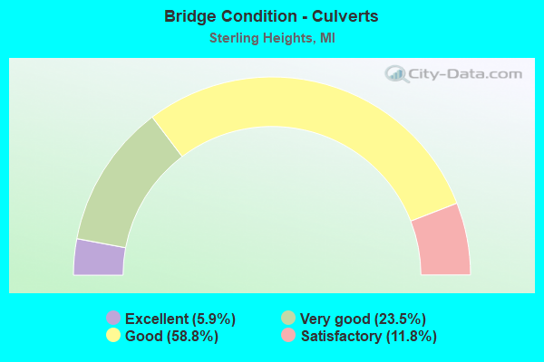
- Bridge Condition - Culverts
- 5.9%Excellent
- 23.5%Very good
- 58.8%Good
- 11.8%Satisfactory
Find on map >> Show street view
Structure Number: 6252, Location: 0.6 MI N OF METRO. PKWY (Lat: 42.572411, Lng: -82.989750), Route carried "on" structure: County highway 2058, Year Built: 1991, Status: Open, Structure Length: 3.96m (12.99ft), Average Daily Traffic: 17,794 (year 2007), Truck Traffic: 7%, Average Future Daily Traffic: 23,968 (year 2027), Design Load: HS 25 or greater, Features Intersected: PLUM BROOK DRAIN, Facility Carried by Structure: NB SCHOENHERR RD
Minimum Vertical Clearance: 30.48m (100.00ft), Kilometerpoint: 13.739, Lanes on structure: 2, Base Highway Network: Yes (Inventory Route: 79, Subroute: 10), Owner: County Highway Agency, Approaching Roadway Width: 7.9m (25.9ft), Material/Design: Prestressed concrete, Design/Construction: Stringer/Multi-beam, Number Of Spans In Main Unit: 2, Length of Maximum Span: 19.2m (63.0ft), Curb or Sidewalk Widths: Left: 0.0m, Right: 1.8m (5.9ft), Curb-To-Curb Width: 9.1m (29.9ft), Out-to-Out Width: 11.8m (38.7ft)
Condition: Deck: Good, Superstructure: Very good, Substructure: Satisfactory, Channel: Poor, Operating Rating: 81.3 metric tons, Method Used To Determine Operating Rating: Load Factor (LF) rating reported by rating factor (RF) method using MS18 loading, Inventory Rating: 48.6 metric tons, Method Used To Determine Inventory Rating: Load Factor (LF) rating reported by rating factor (RF) method using MS18 loading, Structural Evaluation: Equal to present minimum criteria, Deck Geometry: Meets minimum limits, Waterway Adequacy: Equal to present minimum criteria, Approach Roadway Alignment: Equal to present desirable criteria, Designated Inspection Frequency: Every 24 months, Inspection Date: May 2020, Deck Structure Type: Concrete Cast-file-Place, Wearing Surface/Protective System: Wearing Surface: Monolithic Concrete, Deck Protection: Epoxy Coated Reinforcing
Find on map >> Show street view
Structure Number: 6253, Location: 0.6 MI NORTH OF UTICA RD (Lat: 42.585200, Lng: -82.992564), Route carried "on" structure: County highway 2058, Year Built: 1992, Status: Open, Structure Length: 4.87m (15.98ft), Average Daily Traffic: 12,750 (year 2010), Truck Traffic: 3%, Average Future Daily Traffic: 17,174 (year 2030), Design Load: HS 25 or greater, Features Intersected: CLINTON RIVER, Facility Carried by Structure: SCHOENHERR RD NBD
Minimum Vertical Clearance: 30.48m (100.00ft), Kilometerpoint: 15.251, Lanes on structure: 2, Base Highway Network: Yes (Inventory Route: 79, Subroute: 10), Owner: County Highway Agency, Approaching Roadway Width: 8.0m (26.2ft), Material/Design: Prestressed concrete, Design/Construction: Stringer/Multi-beam, Number Of Spans In Main Unit: 2, Length of Maximum Span: 23.7m (77.8ft), Curb or Sidewalk Widths: Left: 0.0m, Right: 1.8m (5.9ft), Curb-To-Curb Width: 9.0m (29.5ft), Out-to-Out Width: 11.8m (38.7ft)
Condition: Deck: Good, Superstructure: Good, Substructure: Good, Channel: Satisfactory, Operating Rating: 97.2 metric tons, Method Used To Determine Operating Rating: Load Factor (LF) rating reported by rating factor (RF) method using MS18 loading, Inventory Rating: 65.8 metric tons, Method Used To Determine Inventory Rating: Load Factor (LF) rating reported by rating factor (RF) method using MS18 loading, Structural Evaluation: Better than present minimum criteria, Deck Geometry: High priority of corrective action, Waterway Adequacy: Equal to present desirable criteria, Approach Roadway Alignment: Equal to present desirable criteria, Designated Inspection Frequency: Every 24 months, Inspection Date: May 2021, Deck Structure Type: Concrete Cast-file-Place, Wearing Surface/Protective System: Wearing Surface: Monolithic Concrete, Deck Protection: Epoxy Coated Reinforcing
Find on map >> Show street view
Structure Number: 6254, Location: 0.6 MI NORTH OF UTICA RD (Lat: 42.585264, Lng: -82.992908), Route carried "on" structure: County highway 2058, Year Built: 1992, Status: Open, Structure Length: 4.87m (15.98ft), Average Daily Traffic: 21,510 (year 2010), Truck Traffic: 3%, Average Future Daily Traffic: 28,974 (year 2030), Design Load: HS 25 or greater, Features Intersected: CLINTON RIVER, Facility Carried by Structure: SCHOENHERR RD SBD
Minimum Vertical Clearance: 30.48m (100.00ft), Kilometerpoint: 5.631, Lanes on structure: 2, Base Highway Network: Yes (Inventory Route: 192, Subroute: 1), Owner: County Highway Agency, Approaching Roadway Width: 8.0m (26.2ft), Material/Design: Prestressed concrete, Design/Construction: Stringer/Multi-beam, Number Of Spans In Main Unit: 2, Length of Maximum Span: 23.7m (77.8ft), Curb or Sidewalk Widths: Left: 0.0m, Right: 1.8m (5.9ft), Curb-To-Curb Width: 9.0m (29.5ft), Out-to-Out Width: 11.8m (38.7ft)
Condition: Deck: Good, Superstructure: Good, Substructure: Good, Channel: Satisfactory, Operating Rating: 97.2 metric tons, Method Used To Determine Operating Rating: Load Factor (LF) rating reported by rating factor (RF) method using MS18 loading, Inventory Rating: 65.8 metric tons, Method Used To Determine Inventory Rating: Load Factor (LF) rating reported by rating factor (RF) method using MS18 loading, Structural Evaluation: Better than present minimum criteria, Deck Geometry: High priority of corrective action, Waterway Adequacy: Equal to present desirable criteria, Approach Roadway Alignment: Equal to present desirable criteria, Designated Inspection Frequency: Every 24 months, Inspection Date: May 2021, Deck Structure Type: Concrete Cast-file-Place, Wearing Surface/Protective System: Wearing Surface: Monolithic Concrete, Deck Protection: Epoxy Coated Reinforcing
Find on map >> Show street view
Structure Number: 6255, Location: 0.1 MI NORTH OF UTICA RD (Lat: 42.570069, Lng: -82.971036), Route carried "on" structure: County highway 2058, Year Built: 1989, Status: Open, Structure Length: 4.87m (15.98ft), Average Daily Traffic: 28,380 (year 2010), Truck Traffic: 7%, Average Future Daily Traffic: 42,173 (year 2030), Design Load: HS 25 or greater, Features Intersected: CLINTON RIVER, Facility Carried by Structure: HAYES RD
Minimum Vertical Clearance: 30.48m (100.00ft), Kilometerpoint: 0.097, Lanes on structure: 5, Owner: County Highway Agency, Approaching Roadway Width: 11.0m (36.1ft), Skew: 1 degrees, Material/Design: Prestressed concrete, Design/Construction: Stringer/Multi-beam, Number Of Spans In Main Unit: 2, Length of Maximum Span: 23.7m (77.8ft), Curb or Sidewalk Widths: Left: 1.5m (4.9ft), Right: 1.5m (4.9ft), Curb-To-Curb Width: 20.1m (65.9ft), Out-to-Out Width: 23.2m (76.1ft)
Condition: Deck: Good, Superstructure: Good, Substructure: Good, Channel: Fair, Operating Rating: 94.3 metric tons, Method Used To Determine Operating Rating: Load Factor (LF) rating reported by rating factor (RF) method using MS18 loading, Inventory Rating: 53.8 metric tons, Method Used To Determine Inventory Rating: Load Factor (LF) rating reported by rating factor (RF) method using MS18 loading, Structural Evaluation: Better than present minimum criteria, Deck Geometry: Somewhat better than minimum adequacy, Waterway Adequacy: Equal to present minimum criteria, Approach Roadway Alignment: Equal to present desirable criteria, Designated Inspection Frequency: Every 24 months, Underwater Inspection Frequency: Every 60 months, Inspection Date: May 2021, Underwater Inspection Date: August 2018, Deck Structure Type: Concrete Cast-file-Place, Wearing Surface/Protective System: Wearing Surface: Monolithic Concrete, Deck Protection: Epoxy Coated Reinforcing
Find on map >> Show street view
Structure Number: 6341, Location: MACOMB TWP SEC 31 & 32 (Lat: 42.627897, Lng: -82.953453), Route carried "on" structure: County highway , Year Built: 1993, Status: Open, Structure Length: 1.09m (3.58ft), Average Daily Traffic: 22,188 (year 2008), Truck Traffic: 3%, Average Future Daily Traffic: 32,971 (year 2028), Design Load: HS 25 or greater, Features Intersected: SALT SLANG GLOEDE DRAIN, Facility Carried by Structure: GARFIELD RD
Minimum Vertical Clearance: 30.48m (100.00ft), Kilometerpoint: 10.551, Lanes on structure: 5, Owner: County Highway Agency, Approaching Roadway Width: 11.9m (39.0ft), Material/Design: Concrete, Design/Construction: Culvert, Number Of Spans In Main Unit: 1, Length of Maximum Span: 10.9m (35.8ft), Curb-To-Curb Width: 18.9m (62.0ft), Out-to-Out Width: 38.4m (126.0ft)
Condition: Channel: Very good, Culverts: Good, Operating Rating: 57.3 metric tons, Method Used To Determine Operating Rating: Field evaluation and documented engineering judgment, Inventory Rating: 34.3 metric tons, Method Used To Determine Inventory Rating: Field evaluation and documented engineering judgment, Structural Evaluation: Better than present minimum criteria, Deck Geometry: Meets minimum limits, Waterway Adequacy: Superior to present desirable criteria, Approach Roadway Alignment: Equal to present desirable criteria, Designated Inspection Frequency: Every 24 months, Inspection Date: June 2020
Find on map >> Show street view
Structure Number: 6345, Location: 0.2 MI E OF ROMEO PLANK (Lat: 42.642764, Lng: -82.933475), Route carried "on" structure: County highway , Year Built: 1979, Status: Open, Structure Length: 3.20m (10.50ft), Average Daily Traffic: 17,600 (year 2019), Truck Traffic: 5%, Average Future Daily Traffic: 18,600 (year 2039), Design Load: HS 20, Features Intersected: MIDDLE BR CLINTON RIVER, Facility Carried by Structure: 21 MILE ROAD
Minimum Vertical Clearance: 30.48m (100.00ft), Kilometerpoint: 8.644, Lanes on structure: 2, Owner: County Highway Agency, Approaching Roadway Width: 11.0m (36.1ft), Skew: 2 degrees, Material/Design: Prestressed concrete, Design/Construction: Box Beam or Girders - Multiple, Number Of Spans In Main Unit: 2, Length of Maximum Span: 15.5m (50.9ft), Curb or Sidewalk Widths: Left: 0.0m, Right: 1.7m (5.6ft), Curb-To-Curb Width: 9.1m (29.9ft), Out-to-Out Width: 11.2m (36.7ft)
Condition: Deck: Good, Superstructure: Satisfactory, Substructure: Satisfactory, Channel: Poor, Operating Rating: 55.4 metric tons, Method Used To Determine Operating Rating: Load Factor (LF) rating reported by rating factor (RF) method using MS18 loading, Inventory Rating: 33.0 metric tons, Method Used To Determine Inventory Rating: Load Factor (LF) rating reported by rating factor (RF) method using MS18 loading, Structural Evaluation: Equal to present minimum criteria, Deck Geometry: High priority of corrective action, Waterway Adequacy: Better than present minimum criteria, Approach Roadway Alignment: Equal to present desirable criteria, Designated Inspection Frequency: Every 24 months, Inspection Date: May 2020, Deck Structure Type: Concrete Cast-file-Place, Wearing Surface/Protective System: Wearing Surface: Bituminous, Membrane: Built-up
Find on map >> Show street view
Structure Number: 6348, Location: 0.8 MI EAST OF HAYES ROAD (Lat: 42.656753, Lng: -82.960439), Route carried "on" structure: County highway , Year Built: 2021, Status: Open, Structure Length: 0.69m (2.26ft), Average Daily Traffic: 15,930 (year 2021), Truck Traffic: 2%, Average Future Daily Traffic: 21,458 (year 2041), Design Load: Greater than HL93, Features Intersected: SALT SLANG GLOEDE DRAIN, Facility Carried by Structure: 22 MILE ROAD
Minimum Vertical Clearance: 30.48m (100.00ft), Kilometerpoint: 9.439, Lanes on structure: 2, Owner: County Highway Agency, Approaching Roadway Width: 12.2m (40.0ft), Skew: 1 degrees, Material/Design: Concrete, Design/Construction: Culvert, Number Of Spans In Main Unit: 1, Length of Maximum Span: 6.9m (22.6ft), Curb-To-Curb Width: 12.2m (40.0ft), Out-to-Out Width: 17.1m (56.1ft)
Condition: Channel: Very good, Culverts: Excellent, Operating Rating: 60.9 metric tons, Method Used To Determine Operating Rating: Load and Resistance Factor Rating (LRFR) rating reported by rating factor(RF) method using HL-93 loadings, Inventory Rating: 47.0 metric tons, Method Used To Determine Inventory Rating: Load and Resistance Factor Rating (LRFR) rating reported by rating factor(RF) method using HL-93 loadings, Structural Evaluation: Superior to present desirable criteria, Deck Geometry: Somewhat better than minimum adequacy, Waterway Adequacy: Equal to present desirable criteria, Approach Roadway Alignment: Equal to present desirable criteria, Designated Inspection Frequency: Every 24 months, Inspection Date: November 2021, Wearing Surface/Protective System: Wearing Surface: Bituminous
Find on map >> Show street view
Structure Number: 6349, Location: 0.1 MI E OF ROMEO PLANK (Lat: 42.657428, Lng: -82.934856), Route carried "on" structure: County highway , Year Built: 1993, Status: Open, Structure Length: 4.87m (15.98ft), Average Daily Traffic: 12,400 (year 2021), Truck Traffic: 3%, Average Future Daily Traffic: 13,100 (year 2041), Design Load: HS 20, Features Intersected: MIDDLE BR CLINTON RIVER, Facility Carried by Structure: 22 MILE ROAD
Minimum Vertical Clearance: 30.48m (100.00ft), Kilometerpoint: 11.538, Lanes on structure: 3, Owner: County Highway Agency, Approaching Roadway Width: 9.1m (29.9ft), Skew: 2 degrees, Material/Design: Prestressed concrete, Design/Construction: Stringer/Multi-beam, Number Of Spans In Main Unit: 2, Length of Maximum Span: 23.4m (76.8ft), Curb or Sidewalk Widths: Left: 1.8m (5.9ft), Right: 1.8m (5.9ft), Curb-To-Curb Width: 11.9m (39.0ft), Out-to-Out Width: 16.5m (54.1ft)
Condition: Deck: Good, Superstructure: Satisfactory, Substructure: Good, Channel: Satisfactory, Operating Rating: 70.0 metric tons, Method Used To Determine Operating Rating: Load Factor (LF) rating reported by rating factor (RF) method using MS18 loading, Inventory Rating: 35.6 metric tons, Method Used To Determine Inventory Rating: Load Factor (LF) rating reported by rating factor (RF) method using MS18 loading, Structural Evaluation: Equal to present minimum criteria, Deck Geometry: High priority of corrective action, Waterway Adequacy: Equal to present minimum criteria, Approach Roadway Alignment: Equal to present desirable criteria, Designated Inspection Frequency: Every 24 months, Inspection Date: June 2020, Deck Structure Type: Concrete Cast-file-Place, Wearing Surface/Protective System: Wearing Surface: Monolithic Concrete, Deck Protection: Epoxy Coated Reinforcing
Find on map >> Show street view
Structure Number: 6361, Location: 0.5 MILE N OF M-59 (Lat: 42.634600, Lng: -82.965900), Route carried "on" structure: County highway , Year Built: 1979, Status: Open, Structure Length: 1.69m (5.54ft), Average Daily Traffic: 4,490 (year 2008), Truck Traffic: 2%, Average Future Daily Traffic: 6,672 (year 2028), Design Load: H 20, Features Intersected: DUNN-BANISTER DRAIN, Facility Carried by Structure: TILCH RD
Minimum Vertical Clearance: 30.48m (100.00ft), Kilometerpoint: 1.291, Lanes on structure: 2, Owner: County Highway Agency, Approaching Roadway Width: 11.0m (36.1ft), Material/Design: Steel, Design/Construction: Culvert, Number Of Spans In Main Unit: 3, Length of Maximum Span: 5.0m (16.4ft), Curb or Sidewalk Widths: Left: 1.5m (4.9ft), Right: 1.5m (4.9ft)
Condition: Channel: Satisfactory, Culverts: Good, Operating Rating: 97.2 metric tons, Method Used To Determine Operating Rating: Load Factor (LF) rating reported by rating factor (RF) method using MS18 loading, Inventory Rating: 61.9 metric tons, Method Used To Determine Inventory Rating: Load Factor (LF) rating reported by rating factor (RF) method using MS18 loading, Structural Evaluation: Better than present minimum criteria, Waterway Adequacy: Superior to present desirable criteria, Approach Roadway Alignment: Equal to present desirable criteria, Designated Inspection Frequency: Every 24 months, Inspection Date: May 2021
Find on map >> Show street view
Structure Number: 6422, Location: WEST OF RYAN RD (Lat: 42.550042, Lng: -83.077458), Route carried "on" structure: City street 2058, Year Built: 1984, Status: Open, Structure Length: 1.03m (3.38ft), Average Daily Traffic: 26,949 (year 2008), Truck Traffic: 5%, Average Future Daily Traffic: 30,400 (year 2020), Design Load: HS 20+Mod, Features Intersected: BIG BEAVER DRAIN, Facility Carried by Structure: 15 MILE RD
Minimum Vertical Clearance: 30.48m (100.00ft), Kilometerpoint: 0.885, Lanes on structure: 5, Owner: City or Municipal Highway Agency, Approaching Roadway Width: 17.7m (58.1ft), Skew: 3 degrees, Material/Design: Concrete, Design/Construction: Culvert, Number Of Spans In Main Unit: 2, Length of Maximum Span: 4.2m (13.8ft), Out-to-Out Width: 50.9m (167.0ft)
Condition: Channel: Serious, Culverts: Good, Operating Rating: 97.2 metric tons, Method Used To Determine Operating Rating: Load Factor (LF) rating reported by rating factor (RF) method using MS18 loading, Inventory Rating: 66.7 metric tons, Method Used To Determine Inventory Rating: Load Factor (LF) rating reported by rating factor (RF) method using MS18 loading, Structural Evaluation: Better than present minimum criteria, Waterway Adequacy: Superior to present desirable criteria, Approach Roadway Alignment: Superior to present desirable criteria, Designated Inspection Frequency: Every 24 months, Inspection Date: September 2020
Find on map >> Show street view
Structure Number: 6423, Location: EAST OF SCHOENHERR RD (Lat: 42.552389, Lng: -82.985856), Route carried "on" structure: City street 2058, Year Built: 1992, Status: Open, Structure Length: 6.40m (21.00ft), Average Daily Traffic: 23,432 (year 2016), Truck Traffic: 5%, Average Future Daily Traffic: 25,790 (year 2036), Design Load: HS 20, Features Intersected: RED RUN DRAIN, Facility Carried by Structure: 15 MILE RD
Minimum Vertical Clearance: 30.48m (100.00ft), Kilometerpoint: 8.430, Lanes on structure: 5, Owner: City or Municipal Highway Agency, Approaching Roadway Width: 17.1m (56.1ft), Skew: 4 degrees, Material/Design: Prestressed concrete, Design/Construction: Stringer/Multi-beam, Number Of Spans In Main Unit: 3, Length of Maximum Span: 21.3m (69.9ft), Curb or Sidewalk Widths: Left: 2.6m (8.5ft), Right: 2.6m (8.5ft), Curb-To-Curb Width: 18.0m (59.1ft), Out-to-Out Width: 23.9m (78.4ft)
Condition: Deck: Satisfactory, Superstructure: Very good, Substructure: Good, Channel: Very good, Operating Rating: 47.6 metric tons, Method Used To Determine Operating Rating: Load Factor (LF) rating reported by rating factor (RF) method using MS18 loading, Inventory Rating: 36.6 metric tons, Method Used To Determine Inventory Rating: Load Factor (LF) rating reported by rating factor (RF) method using MS18 loading, Structural Evaluation: Better than present minimum criteria, Deck Geometry: High priority of replacement, Waterway Adequacy: Equal to present minimum criteria, Approach Roadway Alignment: Equal to present desirable criteria, Length Of Structure Improvement: 21.00m (68.90ft), Designated Inspection Frequency: Every 24 months, Inspection Date: September 2020, Bridge Improvement Cost: $314,000, Total Project Cost: $314,000 ( Estimate for 2017), Deck Structure Type: Concrete Cast-file-Place, Wearing Surface/Protective System: Wearing Surface: Monolithic Concrete, Deck Protection: Epoxy Coated Reinforcing
Find on map >> Show street view
Structure Number: 6424, Location: EAST OF VAN DYKE (M53) (Lat: 42.580525, Lng: -83.025319), Route carried "on" structure: City street , Year Built: 1984, Year Reconstructed: 2003, Status: Posted for load, Structure Length: 3.78m (12.40ft), Average Daily Traffic: 13,790 (year 2011), Truck Traffic: 5%, Average Future Daily Traffic: 24,900 (year 2031), Design Load: HS 20+Mod, Features Intersected: PLUMBROOK DRAIN, Facility Carried by Structure: 17 MILE ROAD
Minimum Vertical Clearance: 30.48m (100.00ft), Kilometerpoint: 5.261, Lanes on structure: 5, Owner: City or Municipal Highway Agency, Approaching Roadway Width: 17.4m (57.1ft), Skew: 3 degrees, Material/Design: Prestressed concrete, Design/Construction: Box Beam or Girders - Multiple, Number Of Spans In Main Unit: 2, Length of Maximum Span: 18.9m (62.0ft), Curb or Sidewalk Widths: Left: 1.5m (4.9ft), Right: 1.5m (4.9ft), Curb-To-Curb Width: 19.2m (63.0ft), Out-to-Out Width: 23.8m (78.1ft)
Condition: Deck: Serious, Superstructure: Serious, Substructure: Good, Channel: Good, Operating Rating: 9.1 metric tons, Method Used To Determine Operating Rating: Load and Resistance Factor Rating (LRFR) rating reported by rating factor(RF) method using HL-93 loadings, Inventory Rating: 7.1 metric tons, Method Used To Determine Inventory Rating: Load and Resistance Factor Rating (LRFR) rating reported by rating factor(RF) method using HL-93 loadings, Structural Evaluation: High priority of corrective action, Deck Geometry: Meets minimum limits, Waterway Adequacy: Equal to present desirable criteria, Approach Roadway Alignment: Equal to present desirable criteria, Bridge Posting: Required (Relationship of Operating Rating to Maximum Legal Load: > 39.9% below), Designated Inspection Frequency: Every 12 months, Inspection Date: April 2021, Deck Structure Type: Concrete Cast-file-Place, Wearing Surface/Protective System: Wearing Surface: Latex Concrete, Deck Protection: Epoxy Coated Reinforcing
Find on map >> Show street view
Structure Number: 6425, Location: EAST OF MOUND RD (Lat: 42.580075, Lng: -83.039942), Route carried "on" structure: City street , Year Built: 1981, Year Reconstructed: 2004, Status: Open, Structure Length: 6.54m (21.46ft), Average Daily Traffic: 17,580 (year 2013), Truck Traffic: 8%, Average Future Daily Traffic: 21,500 (year 2033), Design Load: HS 25 or greater, Features Intersected: CONRAIL RAILROAD, Facility Carried by Structure: 17 MILE RD
Minimum Vertical Clearance: 30.48m (100.00ft), Kilometerpoint: 4.061, Lanes on structure: 5, Owner: City or Municipal Highway Agency, Approaching Roadway Width: 19.8m (65.0ft), Material/Design: Steel continuous, Design/Construction: Stringer/Multi-beam, Number Of Spans In Main Unit: 4, Length of Maximum Span: 24.6m (80.7ft), Curb-To-Curb Width: 20.8m (68.2ft), Out-to-Out Width: 22.0m (72.2ft)
Condition: Deck: Very good, Superstructure: Very good, Substructure: Very good, Operating Rating: 97.2 metric tons, Method Used To Determine Operating Rating: Load Factor (LF) rating reported by rating factor (RF) method using MS18 loading, Inventory Rating: 87.2 metric tons, Method Used To Determine Inventory Rating: Load Factor (LF) rating reported by rating factor (RF) method using MS18 loading, Structural Evaluation: Equal to present desirable criteria, Deck Geometry: Somewhat better than minimum adequacy, Underclear: Equal to present desirable criteria, Approach Roadway Alignment: Equal to present desirable criteria, Designated Inspection Frequency: Every 24 months, Inspection Date: September 2020, Deck Structure Type: Concrete Cast-file-Place, Wearing Surface/Protective System: Wearing Surface: Monolithic Concrete, Deck Protection: Epoxy Coated Reinforcing
Find on map >> Show street view
Structure Number: 6426, Location: EAST OF VAN DYKE AVE (Lat: 42.614211, Lng: -83.025967), Route carried "on" structure: City street , Year Built: 1964, Year Reconstructed: 1998, Status: Open, Structure Length: 3.20m (10.50ft), Average Daily Traffic: 9,479 (year 2016), Truck Traffic: 2%, Average Future Daily Traffic: 10,430 (year 2036), Design Load: HS 25 or greater, Features Intersected: CLINTON RIVER, Facility Carried by Structure: RIVERLAND DR
Minimum Vertical Clearance: 30.48m (100.00ft), Kilometerpoint: 0.496, Lanes on structure: 2, Owner: City or Municipal Highway Agency, Approaching Roadway Width: 8.5m (27.9ft), Material/Design: Steel, Design/Construction: Stringer/Multi-beam, Number Of Spans In Main Unit: 2, Length of Maximum Span: 15.5m (50.9ft), Curb or Sidewalk Widths: Left: 0.0m, Right: 1.5m (4.9ft), Curb-To-Curb Width: 8.5m (27.9ft), Out-to-Out Width: 10.9m (35.8ft)
Condition: Deck: Very good, Superstructure: Very good, Substructure: Very good, Channel: Very good, Operating Rating: 91.7 metric tons, Method Used To Determine Operating Rating: Load Factor (LF) rating reported by rating factor (RF) method using MS18 loading, Inventory Rating: 55.1 metric tons, Method Used To Determine Inventory Rating: Load Factor (LF) rating reported by rating factor (RF) method using MS18 loading, Structural Evaluation: Equal to present desirable criteria, Deck Geometry: High priority of replacement, Waterway Adequacy: Equal to present desirable criteria, Approach Roadway Alignment: Equal to present desirable criteria, Length Of Structure Improvement: 10.50m (34.45ft), Designated Inspection Frequency: Every 24 months, Inspection Date: September 2020, Bridge Improvement Cost: $425,000, Total Project Cost: $425,000 ( Estimate for 2017), Deck Structure Type: Concrete Cast-file-Place, Wearing Surface/Protective System: Wearing Surface: Monolithic Concrete, Deck Protection: Epoxy Coated Reinforcing
Find on map >> Show street view
Structure Number: 6427, Location: S OF 15 MILE RD (Lat: 42.549464, Lng: -83.069236), Route carried "on" structure: City street 2058, Year Built: 1983, Status: Open, Structure Length: 1.03m (3.38ft), Average Daily Traffic: 36,409 (year 2008), Truck Traffic: 5%, Average Future Daily Traffic: 46,200 (year 2020), Design Load: HS 20+Mod, Features Intersected: BIG BEAVER DRAIN, Facility Carried by Structure: RYAN RD
Minimum Vertical Clearance: 30.48m (100.00ft), Kilometerpoint: 11.366, Lanes on structure: 5, Owner: City or Municipal Highway Agency, Approaching Roadway Width: 17.4m (57.1ft), Skew: 3 degrees, Material/Design: Concrete, Design/Construction: Culvert, Number Of Spans In Main Unit: 2, Length of Maximum Span: 3.6m (11.8ft), Curb or Sidewalk Widths: Left: 1.5m (4.9ft), Right: 0.0m, Out-to-Out Width: 54.8m (179.8ft)
Condition: Channel: Fair, Culverts: Good, Operating Rating: 54.1 metric tons, Method Used To Determine Operating Rating: Load Factor (LF) rating reported by rating factor (RF) method using MS18 loading, Inventory Rating: 32.4 metric tons, Method Used To Determine Inventory Rating: Load Factor (LF) rating reported by rating factor (RF) method using MS18 loading, Structural Evaluation: Better than present minimum criteria, Waterway Adequacy: Superior to present desirable criteria, Approach Roadway Alignment: Superior to present desirable criteria, Designated Inspection Frequency: Every 24 months, Inspection Date: September 2020
Find on map >> Show street view
Structure Number: 6428, Location: NORTH OF 18.5 MILE RD (Lat: 42.601464, Lng: -83.071092), Route carried "on" structure: City street 2058, Year Built: 1999, Status: Open, Structure Length: 1.01m (3.31ft), Average Daily Traffic: 11,392 (year 2008), Truck Traffic: 5%, Average Future Daily Traffic: 14,400 (year 2020), Design Load: HS 25 or greater, Features Intersected: PLUM BROOK DRAIN, Facility Carried by Structure: RYAN RD
Minimum Vertical Clearance: 30.48m (100.00ft), Kilometerpoint: 17.143, Lanes on structure: 5, Owner: City or Municipal Highway Agency, Approaching Roadway Width: 16.8m (55.1ft), Skew: 1 degrees, Material/Design: Concrete, Design/Construction: Culvert, Number Of Spans In Main Unit: 1, Length of Maximum Span: 9.8m (32.2ft)
Condition: Channel: Very good, Culverts: Very good, Operating Rating: 54.1 metric tons, Method Used To Determine Operating Rating: Load Factor (LF) rating reported by rating factor (RF) method using MS18 loading, Inventory Rating: 32.4 metric tons, Method Used To Determine Inventory Rating: Load Factor (LF) rating reported by rating factor (RF) method using MS18 loading, Structural Evaluation: Equal to present desirable criteria, Waterway Adequacy: Superior to present desirable criteria, Approach Roadway Alignment: Superior to present desirable criteria, Designated Inspection Frequency: Every 24 months, Inspection Date: September 2020
Find on map >> Show street view
Structure Number: 6429, Location: 0.5 MILE N OF 15 MILE RD (Lat: 42.560847, Lng: -83.009986), Route carried "on" structure: City street 2058, Year Built: 1978, Status: Open, Structure Length: 1.79m (5.87ft), Average Daily Traffic: 16,407 (year 2007), Truck Traffic: 3%, Average Future Daily Traffic: 21,200 (year 2020), Design Load: HS 20+Mod, Features Intersected: STERLING RELIEF DRAIN, Facility Carried by Structure: DODGE PARK RD
Minimum Vertical Clearance: 30.48m (100.00ft), Kilometerpoint: 1.020, Lanes on structure: 2, Owner: City or Municipal Highway Agency, Approaching Roadway Width: 7.0m (23.0ft), Material/Design: Steel, Design/Construction: Culvert, Number Of Spans In Main Unit: 4, Length of Maximum Span: 3.9m (12.8ft)
Condition: Channel: Satisfactory, Culverts: Very good, Operating Rating: 74.5 metric tons, Method Used To Determine Operating Rating: Load Factor (LF) rating reported by rating factor (RF) method using MS18 loading, Inventory Rating: 44.7 metric tons, Method Used To Determine Inventory Rating: Load Factor (LF) rating reported by rating factor (RF) method using MS18 loading, Structural Evaluation: Equal to present desirable criteria, Waterway Adequacy: Equal to present desirable criteria, Approach Roadway Alignment: Equal to present desirable criteria, Designated Inspection Frequency: Every 24 months, Inspection Date: September 2020
Find on map >> Show street view
Structure Number: 643, Location: N OF 16 MILE RD (Lat: 42.574281, Lng: -83.010556), Route carried "on" structure: City street 2058, Year Built: 1973, Status: Open, Structure Length: 2.95m (9.68ft), Average Daily Traffic: 13,796 (year 2007), Truck Traffic: 3%, Average Future Daily Traffic: 17,800 (year 2020), Design Load: HS 20+Mod, Features Intersected: PLUM BROOK DRAIN, Facility Carried by Structure: DODGE PARK RD
Minimum Vertical Clearance: 30.48m (100.00ft), Kilometerpoint: 2.512, Lanes on structure: 3, Owner: City or Municipal Highway Agency, Approaching Roadway Width: 6.7m (22.0ft), Material/Design: Steel, Design/Construction: Stringer/Multi-beam, Number Of Spans In Main Unit: 2, Length of Maximum Span: 14.3m (46.9ft), Curb or Sidewalk Widths: Left: 1.5m (4.9ft), Right: 1.5m (4.9ft), Curb-To-Curb Width: 11.0m (36.1ft), Out-to-Out Width: 14.7m (48.2ft)
Condition: Deck: Good, Superstructure: Good, Substructure: Satisfactory, Channel: Satisfactory, Operating Rating: 68.4 metric tons, Method Used To Determine Operating Rating: Load Factor (LF) rating reported by rating factor (RF) method using MS18 loading, Inventory Rating: 52.8 metric tons, Method Used To Determine Inventory Rating: Load Factor (LF) rating reported by rating factor (RF) method using MS18 loading, Structural Evaluation: Equal to present minimum criteria, Deck Geometry: High priority of replacement, Waterway Adequacy: Equal to present desirable criteria, Approach Roadway Alignment: Equal to present desirable criteria, Designated Inspection Frequency: Every 24 months, Inspection Date: September 2020, Deck Structure Type: Concrete Cast-file-Place, Wearing Surface/Protective System: Wearing Surface: Monolithic Concrete
Find on map >> Show street view
Structure Number: 6431, Location: NORTH OF 14 MILE RD (Lat: 42.538417, Lng: -83.003811), Route carried "on" structure: City street 2058, Year Built: 1985, Status: Open, Structure Length: 5.49m (18.01ft), Average Daily Traffic: 11,677 (year 2016), Truck Traffic: 3%, Average Future Daily Traffic: 12,850 (year 2036), Design Load: HS 20+Mod, Features Intersected: RED RUN DRAIN, Facility Carried by Structure: MAPLE LANE RD
Minimum Vertical Clearance: 30.48m (100.00ft), Kilometerpoint: 0.135, Lanes on structure: 5, Owner: City or Municipal Highway Agency, Approaching Roadway Width: 17.4m (57.1ft), Material/Design: Prestressed concrete, Design/Construction: Box Beam or Girders - Multiple, Number Of Spans In Main Unit: 2, Length of Maximum Span: 26.8m (87.9ft), Curb or Sidewalk Widths: Left: 1.5m (4.9ft), Right: 1.5m (4.9ft), Curb-To-Curb Width: 19.2m (63.0ft), Out-to-Out Width: 23.8m (78.1ft)
Condition: Deck: Good, Superstructure: Satisfactory, Substructure: Good, Channel: Good, Operating Rating: 68.4 metric tons, Method Used To Determine Operating Rating: Load Factor (LF) rating reported by rating factor (RF) method using MS18 loading, Inventory Rating: 52.8 metric tons, Method Used To Determine Inventory Rating: Load Factor (LF) rating reported by rating factor (RF) method using MS18 loading, Structural Evaluation: Equal to present minimum criteria, Deck Geometry: Meets minimum limits, Waterway Adequacy: Equal to present desirable criteria, Approach Roadway Alignment: Equal to present desirable criteria, Length Of Structure Improvement: 20.00m (65.62ft), Designated Inspection Frequency: Every 24 months, Inspection Date: September 2020, Bridge Improvement Cost: $160,000, Total Project Cost: $160,000 ( Estimate for 2017), Deck Structure Type: Concrete Precast Panels, Wearing Surface/Protective System: Wearing Surface: Latex Concrete, Deck Protection: Epoxy Coated Reinforcing
Find on map >> Show street view
Structure Number: 6432, Location: EAST OF RYAN RD (Lat: 42.601450, Lng: -83.057922), Route carried "on" structure: City street , Year Built: 2000, Status: Open, Structure Length: 1.40m (4.59ft), Average Daily Traffic: 1,585 (year 2008), Truck Traffic: 3%, Average Future Daily Traffic: 1,700 (year 2020), Design Load: HS 25 or greater, Features Intersected: PLUM BROOK DRAIN, Facility Carried by Structure: 18.5 MILE RD
Minimum Vertical Clearance: 30.48m (100.00ft), Kilometerpoint: 1.115, Lanes on structure: 3, Owner: City or Municipal Highway Agency, Approaching Roadway Width: 10.1m (33.1ft), Skew: 4 degrees, Material/Design: Concrete, Design/Construction: Culvert, Number Of Spans In Main Unit: 1, Length of Maximum Span: 14.0m (45.9ft), Out-to-Out Width: 61.0m (200.1ft)
Condition: Channel: Good, Culverts: Very good, Operating Rating: 54.1 metric tons, Method Used To Determine Operating Rating: Load Factor (LF) rating reported by rating factor (RF) method using MS18 loading, Inventory Rating: 32.4 metric tons, Method Used To Determine Inventory Rating: Load Factor (LF) rating reported by rating factor (RF) method using MS18 loading, Structural Evaluation: Equal to present desirable criteria, Waterway Adequacy: Superior to present desirable criteria, Approach Roadway Alignment: Superior to present desirable criteria, Designated Inspection Frequency: Every 24 months, Inspection Date: September 2020, Wearing Surface/Protective System: Wearing Surface: Bituminous
Find on map >> Show street view
Structure Number: 13061, Location: 0.1 M W OF GARFIELD RD (Lat: 42.635214, Lng: -82.958489), Route carried "on" structure: County highway , Year Built: 2001, Status: Open, Structure Length: 1.46m (4.79ft), Average Daily Traffic: 350 (year 2001), Average Future Daily Traffic: 570 (year 2021), Design Load: HS 20, Features Intersected: GLODE DRAIN, Facility Carried by Structure: EAST VIEW DRIVE
Minimum Vertical Clearance: 30.48m (100.00ft), Kilometerpoint: 0.183, Lanes on structure: 2, Owner: County Highway Agency, Approaching Roadway Width: 11.0m (36.1ft), Material/Design: Wood or Timber, Design/Construction: Slab, Number Of Spans In Main Unit: 3, Length of Maximum Span: 7.2m (23.6ft), Curb or Sidewalk Widths: Left: 1.5m (4.9ft), Right: 1.5m (4.9ft), Curb-To-Curb Width: 11.0m (36.1ft), Out-to-Out Width: 15.2m (49.9ft)
Condition: Deck: Good, Superstructure: Very good, Substructure: Very good, Channel: Satisfactory, Operating Rating: 61.6 metric tons, Method Used To Determine Operating Rating: Allowable Stress (AS) rating reported by rating factor (RF) method using MS18 loading, Inventory Rating: 45.0 metric tons, Method Used To Determine Inventory Rating: Allowable Stress (AS) rating reported by rating factor (RF) method using MS18 loading, Structural Evaluation: Equal to present desirable criteria, Deck Geometry: Equal to present desirable criteria, Waterway Adequacy: Superior to present desirable criteria, Approach Roadway Alignment: Equal to present desirable criteria, Designated Inspection Frequency: Every 24 months, Inspection Date: May 2021, Deck Structure Type: Wood or Timber, Wearing Surface/Protective System: Wearing Surface: Bituminous, Deck Protection: Other
Find on map >> Show street view
Structure Number: 13207, Location: 0.3 MI N OF 18 MILE RD (Lat: 42.599317, Lng: -83.029314), Route carried "on" structure: State highway 53, Year Built: 2004, Status: Open, Structure Length: 5.54m (18.18ft), Average Daily Traffic: 26,797 (year 2007), Truck Traffic: 5%, Average Future Daily Traffic: 20,930 (year 2025), Design Load: HS 25 or greater, Features Intersected: VAN DYKE RD & M-53 RMP
Minimum Vertical Clearance: 30.48m (100.00ft), Kilometerpoint: 5.720, Lanes on structure: 2, Lanes under structure: 3, Base Highway Network: Yes (Inventory Route: 81, Subroute: 6), Owner: State Highway Agency, Approaching Roadway Width: 14.0m (45.9ft), Material/Design: Prestressed concrete, Design/Construction: Stringer/Multi-beam, Number Of Spans In Main Unit: 2, Length of Maximum Span: 28.0m (91.9ft), Curb-To-Curb Width: 15.2m (49.9ft), Out-to-Out Width: 16.2m (53.1ft)
Condition: Deck: Very good, Superstructure: Very good, Substructure: Good, Operating Rating: 62.2 metric tons, Method Used To Determine Operating Rating: Load Factor (LF) rating reported by rating factor (RF) method using MS18 loading, Inventory Rating: 38.2 metric tons, Method Used To Determine Inventory Rating: Load Factor (LF) rating reported by rating factor (RF) method using MS18 loading, Structural Evaluation: Better than present minimum criteria, Deck Geometry: Superior to present desirable criteria, Underclear: Meets minimum limits, Approach Roadway Alignment: Equal to present desirable criteria, Designated Inspection Frequency: Every 24 months, Inspection Date: November 2021, Deck Structure Type: Concrete Cast-file-Place, Wearing Surface/Protective System: Wearing Surface: Monolithic Concrete, Deck Protection: Epoxy Coated Reinforcing
Find on map >> Show street view
Structure Number: 13533, Location: JUST S OF 17 MILE RD (Lat: 42.579722, Lng: -83.030278), Route carried "on" structure: State highway 53, Year Built: 1988, Status: Open, Structure Length: 0.73m (2.40ft), Average Daily Traffic: 61,396 (year 2007), Truck Traffic: 5%, Average Future Daily Traffic: 72,398 (year 2018), Features Intersected: MOORES DRAIN
Minimum Vertical Clearance: 30.48m (100.00ft), Kilometerpoint: 3.536, Lanes on structure: 6, Base Highway Network: Yes (Inventory Route: 421, Subroute: 8), Owner: State Highway Agency, Approaching Roadway Width: 30.5m (100.1ft), Skew: 20 degrees, Material/Design: Concrete, Design/Construction: Culvert, Number Of Spans In Main Unit: 2, Length of Maximum Span: 3.7m (12.1ft)
Condition: Channel: Good, Culverts: Good, Operating Rating: 97.2 metric tons, Method Used To Determine Operating Rating: Load Factor (LF) rating reported by rating factor (RF) method using MS18 loading, Inventory Rating: 97.2 metric tons, Method Used To Determine Inventory Rating: Load Factor (LF) rating reported by rating factor (RF) method using MS18 loading, Structural Evaluation: Better than present minimum criteria, Waterway Adequacy: Equal to present desirable criteria, Approach Roadway Alignment: Better than present minimum criteria, Designated Inspection Frequency: Every 24 months, Inspection Date: October 2020, Deck Structure Type: Concrete Cast-file-Place, Wearing Surface/Protective System: Wearing Surface: Monolithic Concrete
Find on map >> Show street view
Structure Number: 13577, Location: 0.5 MI N OF 22 MI RD (Lat: 42.663722, Lng: -82.965583), Route carried "on" structure: County highway , Year Built: 1972, Status: Open, Structure Length: 0.64m (2.10ft), Average Daily Traffic: 300 (year 2007), Average Future Daily Traffic: 330 (year 2022), Design Load: HS 20, Features Intersected: SALT SLANG GLOEDE DRAIN, Facility Carried by Structure: GRACECHURCH LANE
Minimum Vertical Clearance: 30.48m (100.00ft), Kilometerpoint: 0.840, Lanes on structure: 2, Owner: County Highway Agency, Approaching Roadway Width: 8.8m (28.9ft), Material/Design: Prestressed concrete, Design/Construction: Box Beam or Girders - Multiple, Number Of Spans In Main Unit: 1, Length of Maximum Span: 6.1m (20.0ft), Curb-To-Curb Width: 8.0m (26.2ft), Out-to-Out Width: 8.7m (28.5ft)
Condition: Deck: Good, Superstructure: Good, Substructure: Satisfactory, Channel: Fair, Operating Rating: 53.2 metric tons, Method Used To Determine Operating Rating: Field evaluation and documented engineering judgment, Inventory Rating: 28.7 metric tons, Method Used To Determine Inventory Rating: Field evaluation and documented engineering judgment, Structural Evaluation: Equal to present minimum criteria, Deck Geometry: Somewhat better than minimum adequacy, Waterway Adequacy: Equal to present desirable criteria, Approach Roadway Alignment: Equal to present desirable criteria, Designated Inspection Frequency: Every 24 months, Inspection Date: August 2020, Deck Structure Type: Concrete Cast-file-Place, Wearing Surface/Protective System: Wearing Surface: Monolithic Concrete
Find on map >> Show street view
Structure Number: 13956, Location: 0.2 MI E OF GAVIOTA LANE (Lat: 42.660078, Lng: -82.963164), Route carried "on" structure: County highway , Year Built: 2016, Status: Open, Structure Length: 0.61m (2.00ft), Average Daily Traffic: 100 (year 2016), Average Future Daily Traffic: 115 (year 2036), Design Load: Greater than HL93, Features Intersected: GLOEDE DRAIN, Facility Carried by Structure: DIAMANTE DRIVE
Minimum Vertical Clearance: 30.48m (100.00ft), Kilometerpoint: 0.000, Lanes on structure: 2, Owner: County Highway Agency, Approaching Roadway Width: 8.5m (27.9ft), Material/Design: Concrete, Design/Construction: Culvert, Number Of Spans In Main Unit: 1, Length of Maximum Span: 6.1m (20.0ft), Curb or Sidewalk Widths: Left: 1.5m (4.9ft), Right: 1.5m (4.9ft), Curb-To-Curb Width: 8.5m (27.9ft), Out-to-Out Width: 18.3m (60.0ft)
Condition: Channel: Very good, Culverts: Very good, Operating Rating: 48.6 metric tons, Method Used To Determine Operating Rating: Load and Resistance Factor Rating (LRFR) rating reported by rating factor(RF) method using HL-93 loadings, Inventory Rating: 37.6 metric tons, Method Used To Determine Inventory Rating: Load and Resistance Factor Rating (LRFR) rating reported by rating factor(RF) method using HL-93 loadings, Structural Evaluation: Equal to present desirable criteria, Deck Geometry: Better than present minimum criteria, Waterway Adequacy: Equal to present desirable criteria, Approach Roadway Alignment: Better than present minimum criteria, Designated Inspection Frequency: Every 24 months, Inspection Date: October 2020, Wearing Surface/Protective System: Wearing Surface: Bituminous
Find on map >> Show street view
Structure Number: 1433, Location: 100 FT W OF GARFIELD RD (Lat: 42.649000, Lng: -82.956900), Route carried "on" structure: County highway , Year Built: 2004, Status: Open, Structure Length: 0.73m (2.40ft), Average Daily Traffic: 80 (year 2003), Average Future Daily Traffic: 145 (year 2023), Design Load: HS 20, Features Intersected: SALT SLING GLOEDE DRAIN, Facility Carried by Structure: HAVERHILL DR
Minimum Vertical Clearance: 30.48m (100.00ft), Kilometerpoint: 1.460, Lanes on structure: 2, Owner: County Highway Agency, Approaching Roadway Width: 11.0m (36.1ft), Material/Design: Concrete, Design/Construction: Culvert, Number Of Spans In Main Unit: 1, Length of Maximum Span: 7.3m (24.0ft), Curb-To-Curb Width: 11.0m (36.1ft), Out-to-Out Width: 26.8m (87.9ft)
Condition: Channel: Good, Culverts: Good, Operating Rating: 54.5 metric tons, Method Used To Determine Operating Rating: Field evaluation and documented engineering judgment, Inventory Rating: 32.7 metric tons, Method Used To Determine Inventory Rating: Field evaluation and documented engineering judgment, Structural Evaluation: Better than present minimum criteria, Deck Geometry: Superior to present desirable criteria, Waterway Adequacy: Equal to present desirable criteria, Approach Roadway Alignment: Better than present minimum criteria, Designated Inspection Frequency: Every 24 months, Inspection Date: August 2021, Wearing Surface/Protective System: Wearing Surface: Low Slump Concrete
Find on map >> Show street view
Structure Number: 6011, Location: 1.9 MI S OF M-59 (Lat: 42.602722, Lng: -83.023369), Route carried "under" structure: County highway 2058, Year Built: 1963, Structure Length: 0. m, Average Daily Traffic: 11,432 (year 1996), Features Intersected: UTICA RD, Facility Carried by Structure: M-53 SB
Minimum Vertical Clearance: 4.44m (14.57ft), Kilometerpoint: 13.826, Lanes on structure: 2, Lanes under structure: 2, Material/Design: Prestressed concrete, Design/Construction: Stringer/Multi-beam, Length of Maximum Span: 20.4m (66.9ft)
Find on map >> Show street view
Structure Number: 6012, Location: 1.2 MI S OF M-59 (Lat: 42.605950, Lng: -83.016161), Route carried "under" structure: State highway 53, Year Built: 1966, Structure Length: 0. m, Average Daily Traffic: 59,000 (year 2010), Truck Traffic: 4%, Features Intersected: M-53, Facility Carried by Structure: CLINTON RIVER RD
Minimum Vertical Clearance: 5.46m (17.91ft), Kilometerpoint: 6.967, Lanes on structure: 2, Lanes under structure: 4, Material/Design: Steel, Design/Construction: Stringer/Multi-beam, Length of Maximum Span: 26.8m (87.9ft)
Find on map >> Show street view
Structure Number: 6013, Location: 0.4 MI S OF M-59 (Lat: 42.619911, Lng: -83.012564), Route carried "under" structure: City street , Year Built: 1966, Structure Length: 0. m, Average Daily Traffic: 2,080 (year 0000), Features Intersected: CANAL RD, Facility Carried by Structure: M-53 SB
Minimum Vertical Clearance: 4.50m (14.76ft), Kilometerpoint: 1.590, Lanes on structure: 2, Lanes under structure: 3, Material/Design: Steel, Design/Construction: Stringer/Multi-beam, Length of Maximum Span: 21.9m (71.9ft)
Find on map >> Show street view
Structure Number: 6016, Location: 1.0 MI S OF M-59 (Lat: 42.609875, Lng: -83.013458), Route carried "under" structure: County highway 2058, Year Built: 1966, Structure Length: 0. m, Average Daily Traffic: 910 (year 1974), Features Intersected: 19 MILE RD, Facility Carried by Structure: M-53 SB
Minimum Vertical Clearance: 4.67m (15.32ft), Kilometerpoint: 0.443, Lanes on structure: 2, Lanes under structure: 2, Material/Design: Prestressed concrete, Design/Construction: Box Beam or Girders - Multiple, Length of Maximum Span: 16.7m (54.8ft)
Find on map >> Show street view
Structure Number: 6017, Location: 1.0 MI S OF M-59 (Lat: 42.609878, Lng: -83.012983), Route carried "under" structure: County highway 2058, Year Built: 1966, Structure Length: 0. m, Average Daily Traffic: 910 (year 1974), Features Intersected: 19 MILE RD, Facility Carried by Structure: M-53 NB
Minimum Vertical Clearance: 4.67m (15.32ft), Kilometerpoint: 0.481, Lanes on structure: 2, Lanes under structure: 2, Material/Design: Prestressed concrete, Design/Construction: Box Beam or Girders - Multiple, Length of Maximum Span: 15.8m (51.8ft)
Find on map >> Show street view
Structure Number: 6018, Location: 1.9 MI S OF M-59 (Lat: 42.602511, Lng: -83.023167), Route carried "under" structure: County highway 2058, Year Built: 1966, Structure Length: 0. m, Average Daily Traffic: 11,432 (year 1996), Features Intersected: UTICA RD, Facility Carried by Structure: M-53 NB
Minimum Vertical Clearance: 4.52m (14.83ft), Kilometerpoint: 13.799, Lanes on structure: 2, Lanes under structure: 2, Material/Design: Prestressed concrete, Design/Construction: Stringer/Multi-beam, Length of Maximum Span: 20.4m (66.9ft)
Find on map >> Show street view
Structure Number: 6019, Location: 0.4 MI S OF M-59 (Lat: 42.619819, Lng: -83.012206), Route carried "under" structure: City street , Year Built: 1966, Structure Length: 0. m, Average Daily Traffic: 910 (year 1974), Features Intersected: CANAL RD, Facility Carried by Structure: M-53 NB
Minimum Vertical Clearance: 4.50m (14.76ft), Kilometerpoint: 1.621, Lanes on structure: 2, Lanes under structure: 3, Material/Design: Steel, Design/Construction: Stringer/Multi-beam, Length of Maximum Span: 21.9m (71.9ft)
Find on map >> Show street view
Structure Number: 6057, Location: @ OAKLAND COUNTY LINE (Lat: 42.625342, Lng: -83.091494), Route carried "under" structure: County highway , Year Built: 1972, Structure Length: 0. m, Average Daily Traffic: 50 (year 0000), Features Intersected: DEQUINDER RD, Facility Carried by Structure: M-59 EB
Minimum Vertical Clearance: 4.60m (15.09ft), Kilometerpoint: 19.817, Lanes on structure: 2, Lanes under structure: 4, Material/Design: Steel, Design/Construction: Stringer/Multi-beam, Length of Maximum Span: 27.2m (89.2ft)
Find on map >> Show street view
Structure Number: 6058, Location: 0.5 WEST OF UTICA (Lat: 42.624458, Lng: -83.061928), Route carried "under" structure: State highway 59, Year Built: 1994, Structure Length: 0. m, Average Daily Traffic: 88,236 (year 2007), Truck Traffic: 3%, Features Intersected: M-59, Facility Carried by Structure: X OVER W/MOUND RD
Minimum Vertical Clearance: 5.05m (16.57ft), Kilometerpoint: 2.437, Lanes on structure: 2, Lanes under structure: 4, Material/Design: Prestressed concrete, Design/Construction: Stringer/Multi-beam, Length of Maximum Span: 28.0m (91.9ft)
Find on map >> Show street view
Structure Number: 6059, Location: 1.5 MI W OF UTICA (Lat: 42.624206, Lng: -83.071772), Route carried "under" structure: City street 2058, Year Built: 1972, Structure Length: 0. m, Average Daily Traffic: 11,507 (year 1996), Truck Traffic: 3%, Features Intersected: RYAN RD, Facility Carried by Structure: M-59 EB
Minimum Vertical Clearance: 4.62m (15.16ft), Kilometerpoint: 19.670, Lanes on structure: 2, Lanes under structure: 2, Material/Design: Steel, Design/Construction: Stringer/Multi-beam, Length of Maximum Span: 35.6m (116.8ft)
Find on map >> Show street view
Structure Number: 606, Location: 1.5 MI W OF UTICA (Lat: 42.624461, Lng: -83.071786), Route carried "under" structure: City street 2058, Year Built: 1971, Structure Length: 0. m, Average Daily Traffic: 11,507 (year 1996), Features Intersected: RYAN RD, Facility Carried by Structure: M-59 WB
Minimum Vertical Clearance: 4.65m (15.26ft), Kilometerpoint: 19.697, Lanes on structure: 2, Lanes under structure: 2, Material/Design: Steel, Design/Construction: Stringer/Multi-beam, Length of Maximum Span: 35.3m (115.8ft)
Find on map >> Show street view
Structure Number: 6061, Location: 0.5 MI. WEST OF UTICA (Lat: 42.624667, Lng: -83.054361), Route carried "under" structure: State highway 59, Year Built: 1994, Structure Length: 0. m, Average Daily Traffic: 88,236 (year 2007), Truck Traffic: 3%, Features Intersected: M-59, Facility Carried by Structure: U TRN W/MOUND RD
Minimum Vertical Clearance: 5.18m (16.99ft), Kilometerpoint: 3.056, Lanes on structure: 4, Lanes under structure: 6, Material/Design: Prestressed concrete, Design/Construction: Stringer/Multi-beam, Length of Maximum Span: 19.8m (65.0ft)
Find on map >> Show street view
Structure Number: 6062, Location: 0.5 MI. WEST OF UTICA (Lat: 42.624725, Lng: -83.052306), Route carried "under" structure: State highway 59, Year Built: 1994, Structure Length: 0. m, Average Daily Traffic: 88,236 (year 2007), Truck Traffic: 3%, Features Intersected: M-59, Facility Carried by Structure: SB MOUND RD
Minimum Vertical Clearance: 5.21m (17.09ft), Kilometerpoint: 3.225, Lanes on structure: 3, Lanes under structure: 6, Material/Design: Prestressed concrete, Design/Construction: Stringer/Multi-beam, Length of Maximum Span: 19.2m (63.0ft)
Find on map >> Show street view
Structure Number: 6063, Location: 0.5 MI. WEST UTICA (Lat: 42.624731, Lng: -83.051875), Route carried "under" structure: State highway 59, Year Built: 1994, Structure Length: 0. m, Average Daily Traffic: 88,236 (year 2007), Truck Traffic: 3%, Features Intersected: M-59, Facility Carried by Structure: NB MOUND RD
Minimum Vertical Clearance: 5.18m (16.99ft), Kilometerpoint: 3.261, Lanes on structure: 3, Lanes under structure: 6, Material/Design: Prestressed concrete, Design/Construction: Stringer/Multi-beam, Length of Maximum Span: 19.2m (63.0ft)
Find on map >> Show street view
Structure Number: 6064, Location: @ OAKLAND COUNTY LINE (Lat: 42.625597, Lng: -83.091508), Route carried "under" structure: County highway , Year Built: 1972, Structure Length: 0. m, Average Daily Traffic: 50 (year 1974), Features Intersected: DEQUINDRE RD, Facility Carried by Structure: M-59 WB
Minimum Vertical Clearance: 4.65m (15.26ft), Kilometerpoint: 19.846, Lanes on structure: 2, Lanes under structure: 4, Material/Design: Steel, Design/Construction: Stringer/Multi-beam, Length of Maximum Span: 27.2m (89.2ft)
Find on map >> Show street view
Structure Number: 6065, Location: 0.5 MI, WEST OF UTICA (Lat: 42.624942, Lng: -83.049861), Route carried "under" structure: State highway 59, Year Built: 1994, Structure Length: 0. m, Average Daily Traffic: 80,406 (year 2007), Truck Traffic: 3%, Features Intersected: M-59, Facility Carried by Structure: U TRN E/MOUND RD
Minimum Vertical Clearance: 5.21m (17.09ft), Kilometerpoint: 3.426, Lanes on structure: 2, Lanes under structure: 6, Material/Design: Prestressed concrete, Design/Construction: Stringer/Multi-beam, Length of Maximum Span: 19.8m (65.0ft)
Find on map >> Show street view
Structure Number: 13207, Location: 0.3 MI N OF 18 MILE RD (Lat: 42.599317, Lng: -83.029314), Route carried "under" structure: County highway , Year Built: 2004, Structure Length: 0. m, Average Daily Traffic: 777,777 (year 0000), Features Intersected: VAN DYKE RD & M-53 RMP, Facility Carried by Structure: M-53 SB
Minimum Vertical Clearance: 5.64m (18.50ft), Kilometerpoint: 0.330, Lanes on structure: 2, Lanes under structure: 2, Material/Design: Prestressed concrete, Design/Construction: Stringer/Multi-beam, Length of Maximum Span: 28.0m (91.9ft)
Find on map >> Show street view
Structure Number: 13207, Location: 0.3 MI N OF 18 MILE RD (Lat: 42.599317, Lng: -83.029314), Route carried "under" structure: Ramp State highway 53, Year Built: 2004, Structure Length: 0. m, Average Daily Traffic: 77,777 (year 0000), Features Intersected: VAN DYKE RD & M-53 RMP
Minimum Vertical Clearance: 5.64m (18.50ft), Kilometerpoint: 0.000, Lanes on structure: 2, Lanes under structure: 1, Material/Design: Prestressed concrete, Design/Construction: Stringer/Multi-beam, Length of Maximum Span: 28.0m (91.9ft)