Bridge Statistics for Texas City, Texas (TX)
Condition, Traffic, Stress, Structural Evaluation, Project Costs
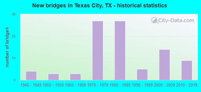
- New bridges - historical statistics
- 41940-1949
- 31950-1959
- 31960-1969
- 271970-1979
- 271980-1989
- 51990-1999
- 142000-2009
- 92010-2019
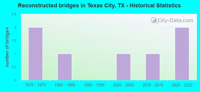
- Reconstructed bridges - Historical Statistics
- 21970-1979
- 11980-1989
- 01990-1999
- 12000-2009
- 12010-2019
- 22020-2022
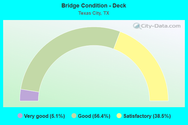
- Bridge Condition - Deck
- 5.1%Very good
- 56.4%Good
- 38.5%Satisfactory
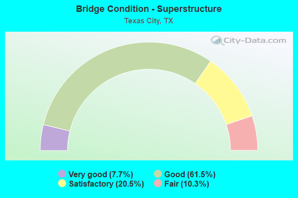
- Bridge Condition - Superstructure
- 7.7%Very good
- 61.5%Good
- 20.5%Satisfactory
- 10.3%Fair
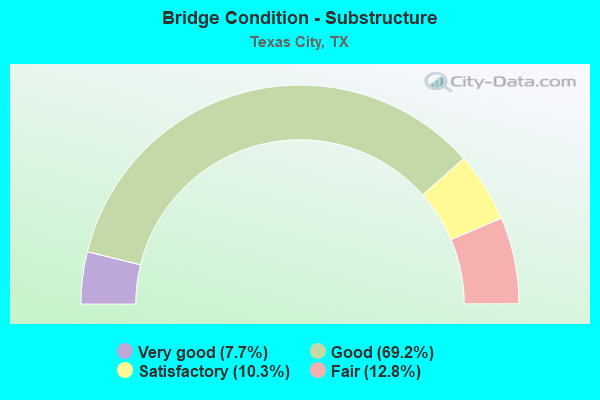
- Bridge Condition - Substructure
- 7.7%Very good
- 69.2%Good
- 10.3%Satisfactory
- 12.8%Fair
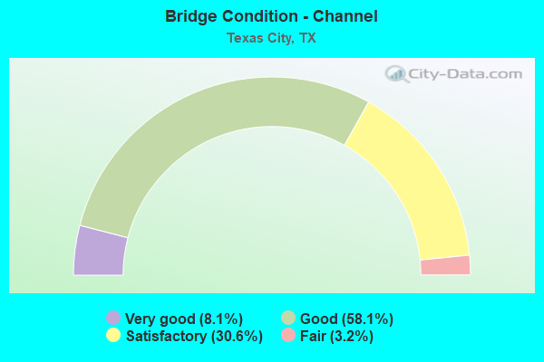
- Bridge Condition - Channel
- 8.1%Very good
- 58.1%Good
- 30.6%Satisfactory
- 3.2%Fair
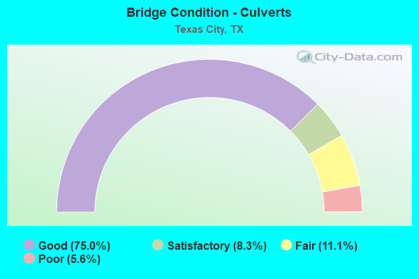
- Bridge Condition - Culverts
- 75.0%Good
- 8.3%Satisfactory
- 11.1%Fair
- 5.6%Poor
Find on map >> Show street view
Structure Number: 120850160701014, Location: 1.70 MI SE OF FM 2004 (Lat: 29.397744, Lng: -95.003486), Route carried "on" structure: State highway 1764, Year Built: 1989, Status: Open, Structure Length: 10.36m (33.99ft), Average Daily Traffic: 33,778 (year 2016), Truck Traffic: 4%, Average Future Daily Traffic: 39,520 (year 2033), Design Load: HS 20, Features Intersected: AMBURN RD
Minimum Vertical Clearance: 30+ m (98+ ft), Kilometerpoint: 11.768, Lanes on structure: 4, Lanes under structure: 8, Owner: State Highway Agency, Approaching Roadway Width: 26.8m (87.9ft), Skew: 30 degrees, Material/Design: Prestressed concrete, Design/Construction: Stringer/Multi-beam, Number Of Spans In Main Unit: 3, Length of Maximum Span: 36.6m (120.1ft), Curb-To-Curb Width: 27.1m (88.9ft), Out-to-Out Width: 28.7m (94.2ft)
Condition: Deck: Satisfactory, Superstructure: Satisfactory, Substructure: Good, Operating Rating: 54.4 metric tons, Method Used To Determine Operating Rating: Assigned rating based on Load Factor Design (LFD) reported in metric tons, Inventory Rating: 32.7 metric tons, Method Used To Determine Inventory Rating: Assigned rating based on Load Factor Design (LFD) reported in metric tons, Structural Evaluation: Equal to present minimum criteria, Deck Geometry: Superior to present desirable criteria, Underclear: High priority of corrective action, Approach Roadway Alignment: Equal to present desirable criteria, Length Of Structure Improvement: 10.36m (33.99ft), Designated Inspection Frequency: Every 24 months, Inspection Date: September 2020, Deck Structure Type: Concrete Precast Panels
Find on map >> Show street view
Structure Number: 120850160701015, Location: 0.70 MI W OF SH 146 (Lat: 29.395764, Lng: -94.962864), Route carried "on" structure: State highway 1764, Year Built: 1989, Status: Open, Structure Length: 3.81m (12.50ft), Average Daily Traffic: 17,401 (year 2020), Truck Traffic: 4%, Average Future Daily Traffic: 20,510 (year 2030), Design Load: HS 20, Features Intersected: DRAINAGE DITCH NO. 7B
Minimum Vertical Clearance: 30+ m (98+ ft), Kilometerpoint: 12.949, Lanes on structure: 2, Owner: State Highway Agency, Approaching Roadway Width: 14.3m (46.9ft), Skew: 2 degrees, Material/Design: Concrete, Design/Construction: Stringer/Multi-beam, Number Of Spans In Main Unit: 3, Length of Maximum Span: 12.8m (42.0ft), Curb-To-Curb Width: 14.3m (46.9ft), Out-to-Out Width: 15.1m (49.5ft)
Condition: Deck: Good, Superstructure: Good, Substructure: Good, Channel: Good, Operating Rating: 68.0 metric tons, Method Used To Determine Operating Rating: Load Factor (LF), Inventory Rating: 40.8 metric tons, Method Used To Determine Inventory Rating: Load Factor (LF), Structural Evaluation: Better than present minimum criteria, Deck Geometry: Superior to present desirable criteria, Waterway Adequacy: Equal to present minimum criteria, Approach Roadway Alignment: Equal to present desirable criteria, Designated Inspection Frequency: Every 24 months, Inspection Date: August 2020, Deck Structure Type: Concrete Cast-file-Place
Find on map >> Show street view
Structure Number: 120850160701016, Location: 0.70 MI W OF SH 146 (Lat: 29.395542, Lng: -94.963364), Route carried "on" structure: State highway 1764, Year Built: 1989, Status: Open, Structure Length: 3.81m (12.50ft), Average Daily Traffic: 14,650 (year 2010), Truck Traffic: 4%, Average Future Daily Traffic: 20,510 (year 2030), Design Load: HS 20, Features Intersected: DRAINAGE DITCH NO 7B
Minimum Vertical Clearance: 30+ m (98+ ft), Kilometerpoint: 12.949, Lanes on structure: 2, Owner: State Highway Agency, Approaching Roadway Width: 14.3m (46.9ft), Skew: 2 degrees, Material/Design: Concrete, Design/Construction: Stringer/Multi-beam, Number Of Spans In Main Unit: 3, Length of Maximum Span: 12.8m (42.0ft), Curb-To-Curb Width: 14.3m (46.9ft), Out-to-Out Width: 15.1m (49.5ft)
Condition: Deck: Satisfactory, Superstructure: Good, Substructure: Good, Channel: Good, Operating Rating: 68.0 metric tons, Method Used To Determine Operating Rating: Load Factor (LF), Inventory Rating: 40.8 metric tons, Method Used To Determine Inventory Rating: Load Factor (LF), Structural Evaluation: Better than present minimum criteria, Deck Geometry: Superior to present desirable criteria, Waterway Adequacy: Equal to present minimum criteria, Approach Roadway Alignment: Equal to present desirable criteria, Designated Inspection Frequency: Every 24 months, Inspection Date: August 2020, Deck Structure Type: Concrete Cast-file-Place
Find on map >> Show street view
Structure Number: 120850160701017, Location: 0.30 MI W OF SH 146 (Lat: 29.395211, Lng: -94.955797), Route carried "on" structure: State highway 1764, Year Built: 1971, Status: Open, Structure Length: 13.41m (44.00ft), Average Daily Traffic: 18,204 (year 2020), Truck Traffic: 4%, Average Future Daily Traffic: 20,760 (year 2033), Design Load: HS 20, Features Intersected: UP RAILROAD
Minimum Vertical Clearance: 30+ m (98+ ft), Kilometerpoint: 16.414, Lanes on structure: 3, Owner: State Highway Agency, Approaching Roadway Width: 17.7m (58.1ft), Skew: 1 degrees, Material/Design: Prestressed concrete, Design/Construction: Stringer/Multi-beam, Number Of Spans In Main Unit: 5, Number Of Approach Spans: 1, Length of Maximum Span: 25.9m (85.0ft), Curb-To-Curb Width: 17.8m (58.4ft), Out-to-Out Width: 18.3m (60.0ft)
Condition: Deck: Good, Superstructure: Fair, Substructure: Satisfactory, Operating Rating: 68.0 metric tons, Method Used To Determine Operating Rating: Load Factor (LF), Inventory Rating: 36.3 metric tons, Method Used To Determine Inventory Rating: Load Factor (LF), Structural Evaluation: Somewhat better than minimum adequacy, Deck Geometry: Better than present minimum criteria, Underclear: Somewhat better than minimum adequacy, Approach Roadway Alignment: Equal to present desirable criteria, Designated Inspection Frequency: Every 24 months, Inspection Date: September 2020, Deck Structure Type: Concrete Cast-file-Place
Find on map >> Show street view
Structure Number: 120850160701291, Location: 1.02 MI E OF SH 3 (Lat: 29.395486, Lng: -94.969758), Route carried "on" structure: State highway 1764, Year Built: 2011, Status: Open, Structure Length: 8.44m (27.69ft), Average Daily Traffic: 29,650 (year 2013), Truck Traffic: 4%, Average Future Daily Traffic: 41,520 (year 2033), Design Load: HS 25 or greater, Features Intersected: WILLOW ST
Minimum Vertical Clearance: 30+ m (98+ ft), Kilometerpoint: 15.102, Lanes on structure: 4, Lanes under structure: 6, Owner: State Highway Agency, Approaching Roadway Width: 28.0m (91.9ft), Material/Design: Prestressed concrete, Design/Construction: Stringer/Multi-beam, Number Of Spans In Main Unit: 3, Length of Maximum Span: 30.8m (101.0ft), Curb-To-Curb Width: 36.0m (118.1ft), Out-to-Out Width: 37.3m (122.4ft)
Condition: Deck: Good, Superstructure: Good, Substructure: Good, Operating Rating: 68.0 metric tons, Method Used To Determine Operating Rating: Assigned rating based on Load Factor Design (LFD) reported in metric tons, Inventory Rating: 40.8 metric tons, Method Used To Determine Inventory Rating: Assigned rating based on Load Factor Design (LFD) reported in metric tons, Structural Evaluation: Better than present minimum criteria, Deck Geometry: Superior to present desirable criteria, Underclear: Superior to present desirable criteria, Approach Roadway Alignment: Equal to present desirable criteria, Designated Inspection Frequency: Every 24 months, Inspection Date: August 2020, Deck Structure Type: Concrete Precast Panels
Find on map >> Show street view
Structure Number: 120850191101001, Location: 1.40 MI N OF FM 1764 (Lat: 29.424850, Lng: -95.031161), Route carried "on" structure: State highway 2004, Year Built: 1940, Status: Open, Structure Length: 0.67m (2.20ft), Average Daily Traffic: 4,317 (year 2020), Truck Traffic: 6%, Average Future Daily Traffic: 6,560 (year 2033), Design Load: H 15, Features Intersected: DRAINAGE DITCH
Minimum Vertical Clearance: 30+ m (98+ ft), Kilometerpoint: 1.876, Lanes on structure: 2, Owner: State Highway Agency, Approaching Roadway Width: 12.5m (41.0ft), Material/Design: Concrete, Design/Construction: Culvert, Number Of Spans In Main Unit: 4, Length of Maximum Span: 1.5m (4.9ft), Curb-To-Curb Width: 12.6m (41.3ft), Out-to-Out Width: 15.4m (50.5ft)
Condition: Channel: Good, Culverts: Good, Operating Rating: 39.9 metric tons, Method Used To Determine Operating Rating: Load Factor (LF), Inventory Rating: 23.6 metric tons, Method Used To Determine Inventory Rating: Load Factor (LF), Structural Evaluation: Equal to present minimum criteria, Deck Geometry: Equal to present minimum criteria, Waterway Adequacy: Equal to present minimum criteria, Approach Roadway Alignment: Equal to present desirable criteria, Designated Inspection Frequency: Every 24 months, Inspection Date: August 2020, Deck Structure Type: Concrete Cast-file-Place, Wearing Surface/Protective System: Wearing Surface: Bituminous
Find on map >> Show street view
Structure Number: 120850191101004, Location: 0.70 MI N OF FM 1764 (Lat: 29.416564, Lng: -95.031036), Route carried "on" structure: State highway 2004, Year Built: 1992, Status: Open, Structure Length: 0.73m (2.40ft), Average Daily Traffic: 4,317 (year 2020), Truck Traffic: 6%, Average Future Daily Traffic: 6,560 (year 2033), Design Load: HS 20, Features Intersected: MOSES BAYOU
Minimum Vertical Clearance: 30+ m (98+ ft), Kilometerpoint: 3.003, Lanes on structure: 2, Owner: State Highway Agency, Approaching Roadway Width: 11.6m (38.1ft), Material/Design: Concrete, Design/Construction: Culvert, Number Of Spans In Main Unit: 2, Length of Maximum Span: 3.0m (9.8ft)
Condition: Channel: Satisfactory, Culverts: Good, Operating Rating: 39.9 metric tons, Method Used To Determine Operating Rating: Load Factor (LF), Inventory Rating: 23.6 metric tons, Method Used To Determine Inventory Rating: Load Factor (LF), Structural Evaluation: Equal to present minimum criteria, Waterway Adequacy: Equal to present minimum criteria, Approach Roadway Alignment: Equal to present desirable criteria, Designated Inspection Frequency: Every 48 months, Inspection Date: September 2020
Find on map >> Show street view
Structure Number: 120850AA0017001, Location: 0.06 Mi. W of Skyline Dr. (Lat: 29.422019, Lng: -94.891983), Route carried "on" structure: County highway , Year Built: 2010, Status: Open, Structure Length: 3.51m (11.52ft), Average Daily Traffic: 560 (year 2011), Average Future Daily Traffic: 620 (year 2031), Design Load: HL 93, Features Intersected: LAGOON, Facility Carried by Structure: BAY ST
Minimum Vertical Clearance: 30+ m (98+ ft), Kilometerpoint: 0.322, Lanes on structure: 2, Owner: County Highway Agency, Approaching Roadway Width: 7.6m (24.9ft), Material/Design: Prestressed concrete, Design/Construction: Box Beam or Girders - Multiple, Number Of Spans In Main Unit: 1, Number Of Approach Spans: 2, Length of Maximum Span: 14.3m (46.9ft), Curb-To-Curb Width: 11.0m (36.1ft), Out-to-Out Width: 11.8m (38.7ft)
Condition: Deck: Very good, Superstructure: Very good, Substructure: Very good, Channel: Good, Operating Rating: 54.4 metric tons, Method Used To Determine Operating Rating: Assigned ratings based on Load and Resistance Factor Design (LRFD) reported in metric tons, Inventory Rating: 32.7 metric tons, Method Used To Determine Inventory Rating: Assigned ratings based on Load and Resistance Factor Design (LRFD) reported in metric tons, Structural Evaluation: Equal to present desirable criteria, Deck Geometry: Better than present minimum criteria, Waterway Adequacy: Better than present minimum criteria, Approach Roadway Alignment: Equal to present desirable criteria, Length Of Structure Improvement: 2.35m (7.71ft), Designated Inspection Frequency: Every 24 months, Inspection Date: October 2021, Bridge Improvement Cost: $4,000, Roadway Improvement Cost: $1,000, Total Project Cost: $5,000, Deck Structure Type: Concrete Cast-file-Place
Find on map >> Show street view
Structure Number: 120850C00017051, Location: 0.4 MI N OF 9TH AVE N (Lat: 29.399036, Lng: -94.893586), Route carried "on" structure: City street , Year Built: 1970, Year Reconstructed: 2015, Status: Posted for load, Structure Length: 1.07m (3.51ft), Average Daily Traffic: 3,000 (year 2011), Average Future Daily Traffic: 3,000 (year 2031), Features Intersected: TARPEY PARK DRAIN, Facility Carried by Structure: BAY ST
Minimum Vertical Clearance: 30+ m (98+ ft), Kilometerpoint: 2.253, Lanes on structure: 4, Owner: Town or Township Highway Agency, Approaching Roadway Width: 14.0m (45.9ft), Material/Design: Concrete, Design/Construction: Culvert, Number Of Spans In Main Unit: 4, Length of Maximum Span: 2.4m (7.9ft), Curb-To-Curb Width: 16.2m (53.1ft), Out-to-Out Width: 19.8m (65.0ft)
Condition: Channel: Good, Culverts: Fair, Operating Rating: 32.7 metric tons, Method Used To Determine Operating Rating: Field evaluation and documented engineering judgment, Inventory Rating: 24.5 metric tons, Method Used To Determine Inventory Rating: Field evaluation and documented engineering judgment, Structural Evaluation: Somewhat better than minimum adequacy, Deck Geometry: Meets minimum limits, Waterway Adequacy: Better than present minimum criteria, Approach Roadway Alignment: Equal to present desirable criteria, Length Of Structure Improvement: 1.07m (3.51ft), Designated Inspection Frequency: Every 24 months, Inspection Date: October 2021, Total Project Cost: $34,000, Deck Structure Type: Concrete Cast-file-Place, Wearing Surface/Protective System: Wearing Surface: Bituminous
Find on map >> Show street view
Structure Number: 120850C00017052, Location: 0.05 MI N OF N 25TH AVE (Lat: 29.408808, Lng: -94.893769), Route carried "on" structure: City street , Year Built: 1990, Status: Open, Structure Length: 2.47m (8.10ft), Average Daily Traffic: 500 (year 2010), Average Future Daily Traffic: 1,000 (year 2030), Features Intersected: DRAINAGE DITCH, Facility Carried by Structure: BAY ST N
Minimum Vertical Clearance: 30+ m (98+ ft), Kilometerpoint: 0.080, Lanes on structure: 2, Owner: Town or Township Highway Agency, Approaching Roadway Width: 7.3m (24.0ft), Material/Design: Prestressed concrete, Design/Construction: Box Beam or Girders - Multiple, Number Of Spans In Main Unit: 1, Length of Maximum Span: 24.7m (81.0ft), Curb-To-Curb Width: 11.2m (36.7ft), Out-to-Out Width: 11.8m (38.7ft)
Condition: Deck: Good, Superstructure: Good, Substructure: Good, Channel: Satisfactory, Operating Rating: 54.4 metric tons, Method Used To Determine Operating Rating: Assigned rating based on Load Factor Design (LFD) reported in metric tons, Inventory Rating: 32.7 metric tons, Method Used To Determine Inventory Rating: Assigned rating based on Load Factor Design (LFD) reported in metric tons, Structural Evaluation: Better than present minimum criteria, Deck Geometry: Better than present minimum criteria, Waterway Adequacy: Better than present minimum criteria, Approach Roadway Alignment: Equal to present desirable criteria, Designated Inspection Frequency: Every 24 months, Inspection Date: October 2021, Deck Structure Type: Concrete Cast-file-Place
Find on map >> Show street view
Structure Number: 120850C00017053, Location: 0.5 MI N OF N 25TH AVE (Lat: 29.414986, Lng: -94.893700), Route carried "on" structure: City street , Year Built: 1985, Status: Posted for load, Structure Length: 3.54m (11.61ft), Average Daily Traffic: 200 (year 2010), Average Future Daily Traffic: 300 (year 2030), Features Intersected: DRAINAGE DITCH, Facility Carried by Structure: BAY ST NORTH
Minimum Vertical Clearance: 30+ m (98+ ft), Kilometerpoint: 0.805, Lanes on structure: 2, Owner: Town or Township Highway Agency, Approaching Roadway Width: 7.3m (24.0ft), Material/Design: Steel, Design/Construction: Culvert, Number Of Spans In Main Unit: 8, Length of Maximum Span: 3.4m (11.2ft)
Condition: Channel: Satisfactory, Culverts: Fair, Operating Rating: 32.7 metric tons, Method Used To Determine Operating Rating: Field evaluation and documented engineering judgment, Inventory Rating: 24.5 metric tons, Method Used To Determine Inventory Rating: Field evaluation and documented engineering judgment, Structural Evaluation: Somewhat better than minimum adequacy, Waterway Adequacy: Better than present minimum criteria, Approach Roadway Alignment: Equal to present desirable criteria, Designated Inspection Frequency: Every 24 months, Inspection Date: October 2021
Find on map >> Show street view
Structure Number: 120850C00066247, Location: 0.65 Mi SW of Beach Drive (Lat: 29.433675, Lng: -94.913158), Route carried "on" structure: City street , Year Built: 2007, Status: Open, Structure Length: 0.82m (2.69ft), Average Daily Traffic: 100 (year 2020), Truck Traffic: 3%, Average Future Daily Traffic: 300 (year 2040), Features Intersected: Moses Lake, Facility Carried by Structure: Grand Cay Drive
Minimum Vertical Clearance: 30+ m (98+ ft), Kilometerpoint: 0.048, Lanes on structure: 2, Owner: City or Municipal Highway Agency, Approaching Roadway Width: 15.2m (49.9ft), Skew: 20 degrees, Material/Design: Concrete, Design/Construction: Culvert, Number Of Spans In Main Unit: 2, Length of Maximum Span: 3.7m (12.1ft), Curb or Sidewalk Widths: Left: 0.0m, Right: 3.0m (9.8ft), Curb-To-Curb Width: 15.2m (49.9ft), Out-to-Out Width: 24.7m (81.0ft)
Condition: Channel: Good, Culverts: Good, Operating Rating: 32.7 metric tons, Method Used To Determine Operating Rating: Field evaluation and documented engineering judgment, Inventory Rating: 24.5 metric tons, Method Used To Determine Inventory Rating: Field evaluation and documented engineering judgment, Structural Evaluation: Equal to present minimum criteria, Deck Geometry: Superior to present desirable criteria, Waterway Adequacy: Superior to present desirable criteria, Approach Roadway Alignment: Equal to present desirable criteria, Designated Inspection Frequency: Every 24 months, Inspection Date: December 2021, Deck Structure Type: Concrete Cast-file-Place, Wearing Surface/Protective System: Wearing Surface: Monolithic Concrete
Find on map >> Show street view
Structure Number: 120850C00066248, Location: 0.6 Mi SW of Beach Drive (Lat: 29.433564, Lng: -94.912003), Route carried "on" structure: City street , Year Built: 2007, Status: Open, Structure Length: 0.88m (2.89ft), Average Daily Traffic: 100 (year 2020), Truck Traffic: 3%, Average Future Daily Traffic: 300 (year 2040), Features Intersected: Moses Lake, Facility Carried by Structure: Grand Cay Drive
Minimum Vertical Clearance: 30+ m (98+ ft), Kilometerpoint: 0.161, Lanes on structure: 2, Owner: City or Municipal Highway Agency, Approaching Roadway Width: 7.6m (24.9ft), Skew: 2 degrees, Material/Design: Concrete, Design/Construction: Culvert, Number Of Spans In Main Unit: 2, Length of Maximum Span: 4.0m (13.1ft), Curb-To-Curb Width: 7.6m (24.9ft), Out-to-Out Width: 24.7m (81.0ft)
Condition: Channel: Good, Culverts: Good, Operating Rating: 32.7 metric tons, Method Used To Determine Operating Rating: Field evaluation and documented engineering judgment, Inventory Rating: 24.5 metric tons, Method Used To Determine Inventory Rating: Field evaluation and documented engineering judgment, Structural Evaluation: Equal to present minimum criteria, Deck Geometry: Equal to present minimum criteria, Waterway Adequacy: Superior to present desirable criteria, Approach Roadway Alignment: Equal to present desirable criteria, Designated Inspection Frequency: Every 24 months, Inspection Date: December 2021, Deck Structure Type: Concrete Cast-file-Place, Wearing Surface/Protective System: Wearing Surface: Monolithic Concrete
Find on map >> Show street view
Structure Number: 120850C00084001, Location: 0.7 MI N OF FM 1764 (Lat: 29.410489, Lng: -95.020150), Route carried "on" structure: City street , Year Built: 1989, Year Reconstructed: 2012, Status: Open, Structure Length: 1.31m (4.30ft), Average Daily Traffic: 320 (year 2014), Average Future Daily Traffic: 350 (year 2034), Features Intersected: MOSES BAYOU, Facility Carried by Structure: CENTURY BLVD
Minimum Vertical Clearance: 30+ m (98+ ft), Kilometerpoint: 2.816, Lanes on structure: 3, Owner: Town or Township Highway Agency, Approaching Roadway Width: 11.6m (38.1ft), Material/Design: Concrete, Design/Construction: Culvert, Number Of Spans In Main Unit: 4, Length of Maximum Span: 2.7m (8.9ft)
Condition: Channel: Very good, Culverts: Good, Operating Rating: 32.7 metric tons, Method Used To Determine Operating Rating: Field evaluation and documented engineering judgment, Inventory Rating: 24.5 metric tons, Method Used To Determine Inventory Rating: Field evaluation and documented engineering judgment, Structural Evaluation: Equal to present minimum criteria, Waterway Adequacy: Better than present minimum criteria, Approach Roadway Alignment: Equal to present desirable criteria, Length Of Structure Improvement: 0.91m (2.99ft), Designated Inspection Frequency: Every 24 months, Inspection Date: November 2021
Find on map >> Show street view
Structure Number: 120850C00092249, Location: 0.75 Mi SE of Holland Rd (Lat: 29.421556, Lng: -95.058947), Route carried "on" structure: City street , Year Built: 2016, Status: Open, Structure Length: 1.37m (4.49ft), Average Daily Traffic: 20 (year 2020), Truck Traffic: 1%, Average Future Daily Traffic: 600 (year 2040), Features Intersected: Drainage Ditch, Facility Carried by Structure: Lago Mar Blvd
Minimum Vertical Clearance: 30+ m (98+ ft), Kilometerpoint: 1.191, Lanes on structure: 4, Owner: City or Municipal Highway Agency, Approaching Roadway Width: 14.6m (47.9ft), Skew: 20 degrees, Material/Design: Concrete, Design/Construction: Culvert, Number Of Spans In Main Unit: 4, Length of Maximum Span: 2.7m (8.9ft), Curb or Sidewalk Widths: Left: 3.9m (12.8ft), Right: 0.0m
Condition: Channel: Very good, Culverts: Good, Operating Rating: 32.7 metric tons, Method Used To Determine Operating Rating: Field evaluation and documented engineering judgment, Inventory Rating: 24.5 metric tons, Method Used To Determine Inventory Rating: Field evaluation and documented engineering judgment, Structural Evaluation: Equal to present minimum criteria, Waterway Adequacy: Superior to present desirable criteria, Approach Roadway Alignment: Equal to present desirable criteria, Designated Inspection Frequency: Every 24 months, Inspection Date: December 2021
Find on map >> Show street view
Structure Number: 120850C00106001, Location: 0.3 MILES EAST SH 146 (Lat: 29.398550, Lng: -94.946600), Route carried "on" structure: County highway , Year Built: 2010, Status: Open, Structure Length: 3.05m (10.01ft), Average Daily Traffic: 100 (year 2012), Truck Traffic: 2%, Average Future Daily Traffic: 150 (year 2034), Features Intersected: DRAINAGE DITCH, Facility Carried by Structure: MAGNOLIA AVE
Minimum Vertical Clearance: 30+ m (98+ ft), Kilometerpoint: 0.483, Lanes on structure: 2, Owner: City or Municipal Highway Agency, Approaching Roadway Width: 8.8m (28.9ft), Material/Design: Prestressed concrete, Design/Construction: Box Beam or Girders - Multiple, Number Of Spans In Main Unit: 1, Number Of Approach Spans: 2, Length of Maximum Span: 12.2m (40.0ft), Curb or Sidewalk Widths: Left: 0.5m (1.6ft), Right: 2.3m (7.5ft), Curb-To-Curb Width: 8.9m (29.2ft), Out-to-Out Width: 12.3m (40.4ft)
Condition: Deck: Good, Superstructure: Good, Substructure: Very good, Channel: Good, Operating Rating: 32.7 metric tons, Method Used To Determine Operating Rating: Field evaluation and documented engineering judgment, Inventory Rating: 24.5 metric tons, Method Used To Determine Inventory Rating: Field evaluation and documented engineering judgment, Structural Evaluation: Equal to present minimum criteria, Deck Geometry: Better than present minimum criteria, Waterway Adequacy: Better than present minimum criteria, Approach Roadway Alignment: Equal to present desirable criteria, Designated Inspection Frequency: Every 24 months, Inspection Date: December 2021, Deck Structure Type: Concrete Cast-file-Place
Find on map >> Show street view
Structure Number: 120850C00123001, Location: 0.3 MILES NW OF FM 1765 (Lat: 29.382283, Lng: -94.972550), Route carried "on" structure: County highway , Year Built: 2010, Status: Open, Structure Length: 1.10m (3.61ft), Average Daily Traffic: 100 (year 2012), Truck Traffic: 2%, Average Future Daily Traffic: 200 (year 2034), Design Load: HS 20, Features Intersected: DITCH #7, Facility Carried by Structure: OAK STREET
Minimum Vertical Clearance: 30+ m (98+ ft), Kilometerpoint: 0.483, Lanes on structure: 2, Owner: City or Municipal Highway Agency, Approaching Roadway Width: 7.3m (24.0ft), Skew: 9 degrees, Material/Design: Concrete, Design/Construction: Culvert, Number Of Spans In Main Unit: 3, Length of Maximum Span: 3.0m (9.8ft)
Condition: Channel: Satisfactory, Culverts: Good, Operating Rating: 54.4 metric tons, Method Used To Determine Operating Rating: Assigned rating based on Load Factor Design (LFD) reported in metric tons, Inventory Rating: 32.7 metric tons, Method Used To Determine Inventory Rating: Assigned rating based on Load Factor Design (LFD) reported in metric tons, Structural Evaluation: Better than present minimum criteria, Waterway Adequacy: Better than present minimum criteria, Approach Roadway Alignment: Equal to present desirable criteria, Designated Inspection Frequency: Every 24 months, Inspection Date: December 2021
Find on map >> Show street view
Structure Number: 120850C0013805, Location: 0.30 MI S OF FM 1764 (Lat: 29.391044, Lng: -94.965194), Route carried "on" structure: City street , Year Built: 2019, Status: Open, Structure Length: 2.29m (7.51ft), Average Daily Traffic: 800 (year 2014), Average Future Daily Traffic: 800 (year 2034), Design Load: HL 93, Features Intersected: DRAINAGE DITCH, Facility Carried by Structure: PINE RD
Minimum Vertical Clearance: 30+ m (98+ ft), Kilometerpoint: 0.483, Lanes on structure: 2, Owner: Town or Township Highway Agency, Approaching Roadway Width: 8.8m (28.9ft), Skew: 3 degrees, Material/Design: Prestressed concrete, Design/Construction: Box Beam or Girders - Multiple, Number Of Spans In Main Unit: 3, Length of Maximum Span: 7.6m (24.9ft), Curb-To-Curb Width: 9.1m (29.9ft), Out-to-Out Width: 9.9m (32.5ft)
Condition: Deck: Good, Superstructure: Very good, Substructure: Very good, Channel: Very good, Operating Rating: 54.4 metric tons, Method Used To Determine Operating Rating: Assigned ratings based on Load and Resistance Factor Design (LRFD) reported in metric tons, Inventory Rating: 32.7 metric tons, Method Used To Determine Inventory Rating: Assigned ratings based on Load and Resistance Factor Design (LRFD) reported in metric tons, Structural Evaluation: Equal to present desirable criteria, Deck Geometry: Equal to present minimum criteria, Waterway Adequacy: Better than present minimum criteria, Approach Roadway Alignment: Equal to present desirable criteria, Designated Inspection Frequency: Every 24 months, Inspection Date: October 2021, Deck Structure Type: Concrete Cast-file-Place
Find on map >> Show street view
Structure Number: 120850C00173001, Location: 0.5 MI E OF SH 146 (Lat: 29.383494, Lng: -94.942717), Route carried "on" structure: City street , Year Built: 1980, Status: Open, Structure Length: 0.73m (2.40ft), Average Daily Traffic: 790 (year 2011), Truck Traffic: 15%, Average Future Daily Traffic: 869 (year 2031), Features Intersected: DRAINAGE DITCH, Facility Carried by Structure: TEXAS AVE
Minimum Vertical Clearance: 30+ m (98+ ft), Kilometerpoint: 0.322, Lanes on structure: 2, Owner: Town or Township Highway Agency, Approaching Roadway Width: 5.5m (18.0ft), Material/Design: Concrete, Design/Construction: Culvert, Number Of Spans In Main Unit: 3, Length of Maximum Span: 2.1m (6.9ft), Curb-To-Curb Width: 5.8m (19.0ft), Out-to-Out Width: 9.9m (32.5ft)
Condition: Channel: Good, Culverts: Good, Operating Rating: 32.7 metric tons, Method Used To Determine Operating Rating: Field evaluation and documented engineering judgment, Inventory Rating: 24.5 metric tons, Method Used To Determine Inventory Rating: Field evaluation and documented engineering judgment, Structural Evaluation: Equal to present minimum criteria, Deck Geometry: High priority of replacement, Waterway Adequacy: Meets minimum limits, Approach Roadway Alignment: Equal to present desirable criteria, Length Of Structure Improvement: 0.73m (2.40ft), Designated Inspection Frequency: Every 24 months, Inspection Date: October 2021, Bridge Improvement Cost: $1,000, Total Project Cost: $1,000, Deck Structure Type: Concrete Cast-file-Place, Wearing Surface/Protective System: Wearing Surface: Bituminous
Find on map >> Show street view
Structure Number: 120850C00193001, Location: 0.05 MI W OF WILLOW RD (Lat: 29.388261, Lng: -94.967917), Route carried "on" structure: City street , Year Built: 2009, Status: Open, Structure Length: 1.86m (6.10ft), Average Daily Traffic: 750 (year 2014), Average Future Daily Traffic: 1,000 (year 2034), Features Intersected: DRAINAGE DITCH, Facility Carried by Structure: 5TH AVE
Minimum Vertical Clearance: 30+ m (98+ ft), Kilometerpoint: 0.161, Lanes on structure: 2, Owner: Town or Township Highway Agency, Approaching Roadway Width: 11.0m (36.1ft), Skew: 3 degrees, Material/Design: Concrete, Design/Construction: Culvert, Number Of Spans In Main Unit: 4, Length of Maximum Span: 3.0m (9.8ft), Curb-To-Curb Width: 14.0m (45.9ft), Out-to-Out Width: 14.6m (47.9ft)
Condition: Channel: Good, Culverts: Good, Operating Rating: 32.7 metric tons, Method Used To Determine Operating Rating: Field evaluation and documented engineering judgment, Inventory Rating: 24.5 metric tons, Method Used To Determine Inventory Rating: Field evaluation and documented engineering judgment, Structural Evaluation: Equal to present minimum criteria, Deck Geometry: Superior to present desirable criteria, Waterway Adequacy: Better than present minimum criteria, Approach Roadway Alignment: Equal to present desirable criteria, Designated Inspection Frequency: Every 24 months, Inspection Date: October 2021, Deck Structure Type: Concrete Precast Panels, Wearing Surface/Protective System: Wearing Surface: Monolithic Concrete
Find on map >> Show street view
Structure Number: 120850C00201001, Location: 0.5 MI E OF SH 146 (Lat: 29.382556, Lng: -94.942697), Route carried "on" structure: City street , Year Built: 1980, Status: Open, Structure Length: 0.73m (2.40ft), Average Daily Traffic: 790 (year 2011), Truck Traffic: 15%, Average Future Daily Traffic: 869 (year 2031), Features Intersected: DRAINAGE DITCH, Facility Carried by Structure: 1ST AVE S
Minimum Vertical Clearance: 30+ m (98+ ft), Kilometerpoint: 0.322, Lanes on structure: 2, Owner: Town or Township Highway Agency, Approaching Roadway Width: 5.8m (19.0ft), Material/Design: Concrete, Design/Construction: Culvert, Number Of Spans In Main Unit: 3, Length of Maximum Span: 2.1m (6.9ft), Curb-To-Curb Width: 6.1m (20.0ft), Out-to-Out Width: 9.8m (32.2ft)
Condition: Channel: Good, Culverts: Satisfactory, Operating Rating: 32.7 metric tons, Method Used To Determine Operating Rating: Field evaluation and documented engineering judgment, Inventory Rating: 24.5 metric tons, Method Used To Determine Inventory Rating: Field evaluation and documented engineering judgment, Structural Evaluation: Equal to present minimum criteria, Deck Geometry: High priority of corrective action, Waterway Adequacy: Meets minimum limits, Approach Roadway Alignment: Equal to present desirable criteria, Length Of Structure Improvement: 0.73m (2.40ft), Designated Inspection Frequency: Every 24 months, Inspection Date: October 2021, Bridge Improvement Cost: $1,000, Total Project Cost: $1,000, Deck Structure Type: Concrete Cast-file-Place, Wearing Surface/Protective System: Wearing Surface: Bituminous
Find on map >> Show street view
Structure Number: 120850C00206001, Location: 0.05 MI N OF N 25TH AVE (Lat: 29.408581, Lng: -94.902714), Route carried "on" structure: City street 6, Year Built: 1987, Status: Open, Structure Length: 1.52m (4.99ft), Average Daily Traffic: 400 (year 2010), Average Future Daily Traffic: 600 (year 2030), Features Intersected: DRAINAGE DITCH
Minimum Vertical Clearance: 30+ m (98+ ft), Kilometerpoint: 0.080, Lanes on structure: 2, Owner: Town or Township Highway Agency, Approaching Roadway Width: 11.0m (36.1ft), Material/Design: Prestressed concrete, Design/Construction: Box Beam or Girders - Multiple, Number Of Spans In Main Unit: 1, Length of Maximum Span: 15.2m (49.9ft), Curb-To-Curb Width: 11.1m (36.4ft), Out-to-Out Width: 11.8m (38.7ft)
Condition: Deck: Satisfactory, Superstructure: Satisfactory, Substructure: Good, Channel: Satisfactory, Operating Rating: 32.7 metric tons, Method Used To Determine Operating Rating: Field evaluation and documented engineering judgment, Inventory Rating: 24.5 metric tons, Method Used To Determine Inventory Rating: Field evaluation and documented engineering judgment, Structural Evaluation: Equal to present minimum criteria, Deck Geometry: Superior to present desirable criteria, Waterway Adequacy: Better than present minimum criteria, Approach Roadway Alignment: Equal to present desirable criteria, Designated Inspection Frequency: Every 24 months, Inspection Date: October 2021, Deck Structure Type: Concrete Cast-file-Place
Find on map >> Show street view
Structure Number: 120850C00208052, Location: 0.3 MI E OF BAY ST (Lat: 29.392150, Lng: -94.889453), Route carried "on" structure: City street , Year Built: 1960, Status: Posted for load, Structure Length: 0.94m (3.08ft), Average Daily Traffic: 3,200 (year 2011), Average Future Daily Traffic: 3,200 (year 2031), Features Intersected: UNNAMED LAGOON, Facility Carried by Structure: EIGHTH AVE
Minimum Vertical Clearance: 30+ m (98+ ft), Kilometerpoint: 1.770, Lanes on structure: 2, Owner: Town or Township Highway Agency, Approaching Roadway Width: 7.3m (24.0ft), Skew: 3 degrees, Material/Design: Concrete, Design/Construction: Culvert, Number Of Spans In Main Unit: 3, Length of Maximum Span: 2.4m (7.9ft), Curb-To-Curb Width: 13.4m (44.0ft), Out-to-Out Width: 13.8m (45.3ft)
Condition: Channel: Satisfactory, Culverts: Poor, Operating Rating: 32.7 metric tons, Method Used To Determine Operating Rating: Field evaluation and documented engineering judgment, Inventory Rating: 24.5 metric tons, Method Used To Determine Inventory Rating: Field evaluation and documented engineering judgment, Structural Evaluation: Meets minimum limits, Deck Geometry: Better than present minimum criteria, Waterway Adequacy: Better than present minimum criteria, Approach Roadway Alignment: Equal to present desirable criteria, Length Of Structure Improvement: 0.94m (3.08ft), Designated Inspection Frequency: Every 24 months, Inspection Date: October 2021, Bridge Improvement Cost: $3,000, Roadway Improvement Cost: $1,000, Total Project Cost: $4,000, Deck Structure Type: Concrete Cast-file-Place, Wearing Surface/Protective System: Wearing Surface: Bituminous
Find on map >> Show street view
Structure Number: 120850C00209001, Location: 0.05 MI N OF 25TH AVE N (Lat: 29.408569, Lng: -94.907825), Route carried "on" structure: City street 9, Year Built: 1987, Status: Open, Structure Length: 1.55m (5.09ft), Average Daily Traffic: 400 (year 2010), Average Future Daily Traffic: 600 (year 2030), Features Intersected: DRAINAGE DITCH
Minimum Vertical Clearance: 30+ m (98+ ft), Kilometerpoint: 0.080, Lanes on structure: 2, Owner: Town or Township Highway Agency, Approaching Roadway Width: 10.7m (35.1ft), Material/Design: Steel, Design/Construction: Culvert, Number Of Spans In Main Unit: 4, Length of Maximum Span: 3.4m (11.2ft)
Condition: Channel: Good, Culverts: Satisfactory, Operating Rating: 32.7 metric tons, Method Used To Determine Operating Rating: Field evaluation and documented engineering judgment, Inventory Rating: 24.5 metric tons, Method Used To Determine Inventory Rating: Field evaluation and documented engineering judgment, Structural Evaluation: Equal to present minimum criteria, Waterway Adequacy: Better than present minimum criteria, Approach Roadway Alignment: Equal to present desirable criteria, Designated Inspection Frequency: Every 24 months, Inspection Date: November 2021
Find on map >> Show street view
Structure Number: 120850C00219001, Location: 19TH AVE AT 16TH ST. (Lat: 29.402908, Lng: -94.919261), Route carried "on" structure: City street , Year Built: 1980, Status: Posted for load, Structure Length: 1.16m (3.81ft), Average Daily Traffic: 2,250 (year 2011), Average Future Daily Traffic: 2,475 (year 2031), Features Intersected: DRAINAGE DITCH, Facility Carried by Structure: 13TH THRU 19TH AVE
Minimum Vertical Clearance: 30+ m (98+ ft), Kilometerpoint: 0.644, Lanes on structure: 2, Owner: Town or Township Highway Agency, Approaching Roadway Width: 10.4m (34.1ft), Material/Design: Concrete, Design/Construction: Culvert, Number Of Spans In Main Unit: 4, Length of Maximum Span: 2.7m (8.9ft), Curb or Sidewalk Widths: Left: 1.1m (3.6ft), Right: 1.1m (3.6ft)
Condition: Channel: Good, Culverts: Poor, Operating Rating: 32.7 metric tons, Method Used To Determine Operating Rating: Field evaluation and documented engineering judgment, Inventory Rating: 24.5 metric tons, Method Used To Determine Inventory Rating: Field evaluation and documented engineering judgment, Structural Evaluation: Meets minimum limits, Waterway Adequacy: Better than present minimum criteria, Approach Roadway Alignment: Equal to present desirable criteria, Length Of Structure Improvement: 1.16m (3.81ft), Designated Inspection Frequency: Every 24 months, Inspection Date: October 2021
Find on map >> Show street view
Structure Number: 120850C00219002, Location: 19TH AVE AT 14TH ST. (Lat: 29.403575, Lng: -94.914192), Route carried "on" structure: City street , Year Built: 1980, Status: Posted for load, Structure Length: 1.16m (3.81ft), Average Daily Traffic: 1,300 (year 2011), Average Future Daily Traffic: 1,430 (year 2031), Features Intersected: DRAINAGE DITCH, Facility Carried by Structure: 19TH AVE
Minimum Vertical Clearance: 30+ m (98+ ft), Kilometerpoint: 1.287, Lanes on structure: 2, Owner: Town or Township Highway Agency, Approaching Roadway Width: 10.4m (34.1ft), Material/Design: Concrete, Design/Construction: Culvert, Number Of Spans In Main Unit: 4, Length of Maximum Span: 2.7m (8.9ft), Curb or Sidewalk Widths: Left: 1.2m (3.9ft), Right: 0.0m
Condition: Channel: Good, Culverts: Fair, Operating Rating: 32.7 metric tons, Method Used To Determine Operating Rating: No rating analysis performed, Inventory Rating: 24.5 metric tons, Method Used To Determine Inventory Rating: No rating analysis performed, Structural Evaluation: Somewhat better than minimum adequacy, Waterway Adequacy: Better than present minimum criteria, Approach Roadway Alignment: Equal to present desirable criteria, Length Of Structure Improvement: 1.16m (3.81ft), Designated Inspection Frequency: Every 24 months, Inspection Date: October 2021
Find on map >> Show street view
Structure Number: 120850C00234246, Location: 0.55 MI N of FM 1765 (Lat: 29.387933, Lng: -94.946842), Route carried "on" structure: City street , Year Built: 1980, Status: Open, Structure Length: 1.68m (5.51ft), Average Daily Traffic: 2,543 (year 2018), Truck Traffic: 9%, Average Future Daily Traffic: 3,560 (year 2038), Design Load: HS 20, Features Intersected: Drainage Ditch #14, Facility Carried by Structure: 34th Street N
Minimum Vertical Clearance: 30+ m (98+ ft), Kilometerpoint: 0.966, Lanes on structure: 2, Owner: City or Municipal Highway Agency, Approaching Roadway Width: 6.4m (21.0ft), Skew: 3 degrees, Material/Design: Aluminum, Iron, Design/Construction: Culvert, Number Of Spans In Main Unit: 4, Length of Maximum Span: 3.7m (12.1ft), Curb-To-Curb Width: 9.6m (31.5ft), Out-to-Out Width: 16.9m (55.4ft)
Condition: Channel: Satisfactory, Culverts: Good, Operating Rating: 54.4 metric tons, Method Used To Determine Operating Rating: Assigned rating based on Load Factor Design (LFD) reported in metric tons, Inventory Rating: 32.7 metric tons, Method Used To Determine Inventory Rating: Assigned rating based on Load Factor Design (LFD) reported in metric tons, Structural Evaluation: Better than present minimum criteria, Deck Geometry: Meets minimum limits, Waterway Adequacy: Better than present minimum criteria, Approach Roadway Alignment: Equal to present desirable criteria, Designated Inspection Frequency: Every 24 months, Inspection Date: December 2021, Deck Structure Type: Aluminum, Wearing Surface/Protective System: Wearing Surface: Bituminous
Find on map >> Show street view
Structure Number: 120850C00725001, Location: 0.8 MI W OF SH 146 (Lat: 29.408067, Lng: -94.969442), Route carried "on" structure: City street , Year Built: 2007, Status: Open, Structure Length: 1.52m (4.99ft), Average Daily Traffic: 5,800 (year 2011), Average Future Daily Traffic: 6,380 (year 2031), Features Intersected: DITCH, Facility Carried by Structure: 25TH AVENUE N
Minimum Vertical Clearance: 30+ m (98+ ft), Kilometerpoint: 2.334, Lanes on structure: 4, Owner: Town or Township Highway Agency, Approaching Roadway Width: 14.6m (47.9ft), Skew: 3 degrees, Material/Design: Prestressed concrete, Design/Construction: Slab, Number Of Spans In Main Unit: 1, Length of Maximum Span: 15.2m (49.9ft), Curb-To-Curb Width: 16.6m (54.5ft), Out-to-Out Width: 17.2m (56.4ft)
Condition: Deck: Good, Superstructure: Good, Substructure: Good, Channel: Good, Operating Rating: 32.7 metric tons, Method Used To Determine Operating Rating: Field evaluation and documented engineering judgment, Inventory Rating: 24.5 metric tons, Method Used To Determine Inventory Rating: Field evaluation and documented engineering judgment, Structural Evaluation: Equal to present minimum criteria, Deck Geometry: Somewhat better than minimum adequacy, Waterway Adequacy: Better than present minimum criteria, Approach Roadway Alignment: Equal to present desirable criteria, Designated Inspection Frequency: Every 24 months, Inspection Date: October 2021, Deck Structure Type: Concrete Cast-file-Place
Find on map >> Show street view
Structure Number: 120850C00725002, Location: 0.2 MI E OF SH 146 (Lat: 29.407958, Lng: -94.951714), Route carried "on" structure: City street , Year Built: 2006, Status: Open, Structure Length: 1.04m (3.41ft), Average Daily Traffic: 15,400 (year 2011), Average Future Daily Traffic: 16,940 (year 2031), Features Intersected: DITCH, Facility Carried by Structure: 25TH AVENUE N
Minimum Vertical Clearance: 30+ m (98+ ft), Kilometerpoint: 4.265, Lanes on structure: 5, Owner: Town or Township Highway Agency, Approaching Roadway Width: 17.4m (57.1ft), Material/Design: Concrete, Design/Construction: Culvert, Number Of Spans In Main Unit: 3, Length of Maximum Span: 3.0m (9.8ft), Curb or Sidewalk Widths: Left: 1.4m (4.6ft), Right: 1.3m (4.3ft), Curb-To-Curb Width: 17.4m (57.1ft), Out-to-Out Width: 20.8m (68.2ft)
Condition: Channel: Very good, Culverts: Good, Operating Rating: 32.7 metric tons, Method Used To Determine Operating Rating: Field evaluation and documented engineering judgment, Inventory Rating: 24.5 metric tons, Method Used To Determine Inventory Rating: Field evaluation and documented engineering judgment, Structural Evaluation: Equal to present minimum criteria, Deck Geometry: High priority of replacement, Waterway Adequacy: Better than present minimum criteria, Approach Roadway Alignment: Equal to present desirable criteria, Length Of Structure Improvement: 1.04m (3.41ft), Designated Inspection Frequency: Every 24 months, Inspection Date: October 2021, Bridge Improvement Cost: $4,000, Roadway Improvement Cost: $1,000, Total Project Cost: $5,000, Deck Structure Type: Concrete Cast-file-Place, Wearing Surface/Protective System: Wearing Surface: Monolithic Concrete
Find on map >> Show street view
Structure Number: 120850C00725003, Location: 0.5 MI E OF SH 146 (Lat: 29.407997, Lng: -94.947911), Route carried "on" structure: City street , Year Built: 2006, Status: Open, Structure Length: 1.43m (4.69ft), Average Daily Traffic: 15,400 (year 2011), Average Future Daily Traffic: 16,940 (year 2031), Features Intersected: DITCH, Facility Carried by Structure: 25TH AVENUE N
Minimum Vertical Clearance: 30+ m (98+ ft), Kilometerpoint: 4.748, Lanes on structure: 5, Owner: Town or Township Highway Agency, Approaching Roadway Width: 17.4m (57.1ft), Material/Design: Concrete, Design/Construction: Culvert, Number Of Spans In Main Unit: 4, Length of Maximum Span: 3.0m (9.8ft), Curb or Sidewalk Widths: Left: 1.4m (4.6ft), Right: 1.4m (4.6ft), Curb-To-Curb Width: 17.4m (57.1ft), Out-to-Out Width: 20.8m (68.2ft)
Condition: Channel: Good, Culverts: Good, Operating Rating: 32.7 metric tons, Method Used To Determine Operating Rating: Field evaluation and documented engineering judgment, Inventory Rating: 24.5 metric tons, Method Used To Determine Inventory Rating: Field evaluation and documented engineering judgment, Structural Evaluation: Equal to present minimum criteria, Deck Geometry: High priority of replacement, Waterway Adequacy: Better than present minimum criteria, Approach Roadway Alignment: Equal to present desirable criteria, Length Of Structure Improvement: 1.40m (4.59ft), Designated Inspection Frequency: Every 24 months, Inspection Date: October 2021, Bridge Improvement Cost: $5,000, Roadway Improvement Cost: $1,000, Total Project Cost: $6,000, Deck Structure Type: Concrete Cast-file-Place, Wearing Surface/Protective System: Wearing Surface: Monolithic Concrete
Find on map >> Show street view
Structure Number: 120850C00725004, Location: 0.31 MI W OF 14TH ST (Lat: 29.407981, Lng: -94.919719), Route carried "on" structure: City street , Year Built: 2006, Status: Open, Structure Length: 1.95m (6.40ft), Average Daily Traffic: 15,400 (year 2011), Average Future Daily Traffic: 16,940 (year 2031), Features Intersected: DITCH, Facility Carried by Structure: 25TH AVENUE N
Minimum Vertical Clearance: 30+ m (98+ ft), Kilometerpoint: 7.483, Lanes on structure: 5, Owner: Town or Township Highway Agency, Approaching Roadway Width: 19.2m (63.0ft), Material/Design: Concrete, Design/Construction: Culvert, Number Of Spans In Main Unit: 6, Length of Maximum Span: 2.7m (8.9ft), Curb or Sidewalk Widths: Left: 1.3m (4.3ft), Right: 1.3m (4.3ft), Curb-To-Curb Width: 19.2m (63.0ft), Out-to-Out Width: 26.4m (86.6ft)
Condition: Channel: Good, Culverts: Good, Operating Rating: 32.7 metric tons, Method Used To Determine Operating Rating: No rating analysis performed, Inventory Rating: 24.5 metric tons, Method Used To Determine Inventory Rating: No rating analysis performed, Structural Evaluation: Equal to present minimum criteria, Deck Geometry: Meets minimum limits, Waterway Adequacy: Better than present minimum criteria, Approach Roadway Alignment: Equal to present desirable criteria, Designated Inspection Frequency: Every 24 months, Inspection Date: October 2021, Deck Structure Type: Concrete Cast-file-Place, Wearing Surface/Protective System: Wearing Surface: Monolithic Concrete
Find on map >> Show street view
Structure Number: 120850C00725005, Location: 25TH AVE AT 13TH/14TH ST (Lat: 29.408000, Lng: -94.914239), Route carried "on" structure: City street , Year Built: 2006, Status: Open, Structure Length: 1.95m (6.40ft), Average Daily Traffic: 15,400 (year 2011), Average Future Daily Traffic: 16,940 (year 2031), Features Intersected: Ditch, Facility Carried by Structure: 25th Avenue N.
Minimum Vertical Clearance: 30+ m (98+ ft), Kilometerpoint: 7.966, Lanes on structure: 5, Owner: Town or Township Highway Agency, Approaching Roadway Width: 19.2m (63.0ft), Material/Design: Concrete, Design/Construction: Culvert, Number Of Spans In Main Unit: 6, Length of Maximum Span: 2.7m (8.9ft), Curb or Sidewalk Widths: Left: 2.1m (6.9ft), Right: 1.3m (4.3ft), Curb-To-Curb Width: 19.2m (63.0ft), Out-to-Out Width: 28.1m (92.2ft)
Condition: Channel: Satisfactory, Culverts: Good, Operating Rating: 32.7 metric tons, Method Used To Determine Operating Rating: Field evaluation and documented engineering judgment, Inventory Rating: 24.5 metric tons, Method Used To Determine Inventory Rating: Field evaluation and documented engineering judgment, Structural Evaluation: Equal to present minimum criteria, Deck Geometry: Meets minimum limits, Waterway Adequacy: Better than present minimum criteria, Approach Roadway Alignment: Equal to present desirable criteria, Designated Inspection Frequency: Every 24 months, Inspection Date: October 2021, Deck Structure Type: Concrete Cast-file-Place, Wearing Surface/Protective System: Wearing Surface: Monolithic Concrete
Find on map >> Show street view
Structure Number: 120850005103042, Location: 1.10 MI NW OF SH 197 (Lat: 29.350714, Lng: -94.942492), Route carried "under" structure: State highway 3, Year Built: 1968, Structure Length: 0. m, Average Daily Traffic: 3,200 (year 2013), Truck Traffic: 6%, Features Intersected: SH3/UP/TCT/GH&H RR, Facility Carried by Structure: SH 146
Minimum Vertical Clearance: 6.61m (21.69ft), Kilometerpoint: 26.425, Lanes on structure: 2, Lanes under structure: 4, Material/Design: Steel continuous, Design/Construction: Stringer/Multi-beam, Length of Maximum Span: 30.5m (100.1ft)
Find on map >> Show street view
Structure Number: 120850005103043, Location: @INT. OF SH-3 & FM 1764 (Lat: 29.396164, Lng: -94.986050), Route carried "under" structure: State highway 3, Year Built: 1971, Structure Length: 0. m, Average Daily Traffic: 5,460 (year 2013), Truck Traffic: 6%, Features Intersected: SH 3 / UP RR, Facility Carried by Structure: FM 1764 EB
Minimum Vertical Clearance: 7.34m (24.08ft), Kilometerpoint: 19.560, Lanes on structure: 2, Lanes under structure: 7, Material/Design: Prestressed concrete, Design/Construction: Stringer/Multi-beam, Length of Maximum Span: 24.4m (80.1ft)
Find on map >> Show street view
Structure Number: 120850005103054, Location: @INT. OF SH-3 & FM 1764 (Lat: 29.396339, Lng: -94.986183), Route carried "under" structure: State highway 3, Year Built: 1971, Structure Length: 0. m, Average Daily Traffic: 5,460 (year 2013), Truck Traffic: 6%, Features Intersected: SH 3 / UP RR, Facility Carried by Structure: FM 1764 WB
Minimum Vertical Clearance: 7.04m (23.10ft), Kilometerpoint: 19.560, Lanes on structure: 2, Lanes under structure: 7, Material/Design: Prestressed concrete, Design/Construction: Stringer/Multi-beam, Length of Maximum Span: 24.4m (80.1ft)
Find on map >> Show street view
Structure Number: 120850038906012, Location: 1.0 MI N OF FM 1764 (Lat: 29.410875, Lng: -94.958386), Route carried "under" structure: Spur State highway 197, Year Built: 2006, Structure Length: 0. m, Average Daily Traffic: 17,500 (year 2013), Truck Traffic: 4%, Features Intersected: LP 197 & DRAIN DITCH 7B, Facility Carried by Structure: SH 146 NBML
Minimum Vertical Clearance: 5.33m (17.49ft), Kilometerpoint: 13.853, Lanes on structure: 2, Lanes under structure: 8, Material/Design: Steel, Design/Construction: Stringer/Multi-beam, Length of Maximum Span: 61.0m (200.1ft)
Find on map >> Show street view
Structure Number: 120850038906065, Location: 1.10 MI N OF FM 1765 (Lat: 29.395331, Lng: -94.950969), Route carried "under" structure: State highway 1764, Year Built: 1971, Structure Length: 0. m, Average Daily Traffic: 13,380 (year 2013), Truck Traffic: 7%, Features Intersected: FM 1764, Facility Carried by Structure: SH 146 NB
Minimum Vertical Clearance: 5.39m (17.68ft), Kilometerpoint: 16.950, Lanes on structure: 2, Lanes under structure: 8, Material/Design: Prestressed concrete, Design/Construction: Stringer/Multi-beam, Length of Maximum Span: 22.3m (73.2ft)
Find on map >> Show street view
Structure Number: 120850038906068, Location: 0.80 MI SE OF FM 517 (Lat: 29.461533, Lng: -94.972533), Route carried "under" structure: State highway 146, Year Built: 1976, Structure Length: 0. m, Truck Traffic: 8%, Features Intersected: Dickinson Bayou
Minimum Vertical Clearance: 30+ m (98+ ft), Kilometerpoint: 10.588, Lanes on structure: 2, Lanes under structure: 2, Material/Design: Prestressed concrete, Design/Construction: Stringer/Multi-beam, Length of Maximum Span: 30.5m (100.1ft)
Find on map >> Show street view
Structure Number: 120850038906095, Location: 1.10 MI N OF FM 1765 (Lat: 29.395303, Lng: -94.951175), Route carried "under" structure: State highway 1764, Year Built: 1971, Structure Length: 0. m, Average Daily Traffic: 29,650 (year 2013), Truck Traffic: 4%, Features Intersected: FM 1764, Facility Carried by Structure: SH 146 SB
Minimum Vertical Clearance: 5.36m (17.59ft), Kilometerpoint: 16.927, Lanes on structure: 2, Lanes under structure: 8, Material/Design: Prestressed concrete, Design/Construction: Stringer/Multi-beam, Length of Maximum Span: 22.3m (73.2ft)
Find on map >> Show street view
Structure Number: 120850038906117, Location: 0.80 MI SE OF FM 517 (Lat: 29.464300, Lng: -94.974628), Route carried "under" structure: State highway 146, Year Built: 2009, Structure Length: 0. m, Average Daily Traffic: 9,420 (year 2013), Truck Traffic: 8%, Features Intersected: DICKINSON BAYOU
Minimum Vertical Clearance: 30+ m (98+ ft), Kilometerpoint: 10.470, Lanes on structure: 2, Material/Design: Prestressed concrete, Design/Construction: Stringer/Multi-beam, Length of Maximum Span: 34.4m (112.9ft)
Find on map >> Show street view
Structure Number: 120850038906357, Location: 1.0 MI N OF FM 1764 (Lat: 29.410800, Lng: -94.958650), Route carried "under" structure: Spur State highway 197, Year Built: 2012, Structure Length: 0. m, Average Daily Traffic: 6,000 (year 2010), Features Intersected: LP 197 & DRAIN DITCH 7B, Facility Carried by Structure: SH 146 SBML
Minimum Vertical Clearance: 5.87m (19.26ft), Kilometerpoint: 13.853, Lanes on structure: 2, Lanes under structure: 8, Material/Design: Steel, Design/Construction: Stringer/Multi-beam, Length of Maximum Span: 61.0m (200.1ft)
Find on map >> Show street view
Structure Number: 120850050004188, Location: 1.60 MI SE OF FM 517 (Lat: 29.430406, Lng: -95.060253), Route carried "under" structure: Interstate 45, Year Built: 1979, Structure Length: 0. m, Average Daily Traffic: 85,530 (year 2013), Truck Traffic: 4%, Features Intersected: IH 45, Facility Carried by Structure: HOLLAND RD
Minimum Vertical Clearance: 5.01m (16.44ft), Kilometerpoint: 17.563, Lanes on structure: 2, Lanes under structure: 8, Material/Design: Prestressed concrete, Design/Construction: Stringer/Multi-beam, Length of Maximum Span: 32.9m (107.9ft)
Find on map >> Show street view
Structure Number: 120850050004191, Location: 0.70 MI SE OF FM 517 (Lat: 29.441058, Lng: -95.070492), Route carried "under" structure: Interstate 45, Year Built: 1979, Structure Length: 0. m, Average Daily Traffic: 85,530 (year 2013), Truck Traffic: 4%, Features Intersected: IH 45, Facility Carried by Structure: HUGHES ROAD
Minimum Vertical Clearance: 5.49m (18.01ft), Kilometerpoint: 19.096, Lanes on structure: 2, Lanes under structure: 10, Material/Design: Prestressed concrete, Design/Construction: Stringer/Multi-beam, Length of Maximum Span: 25.9m (85.0ft)
Find on map >> Show street view
Structure Number: 120850160701011, Location: 0.30 MI W OF SH 146 (Lat: 29.395394, Lng: -94.955786), Route carried "under" structure: State highway 1764, Year Built: 1971, Structure Length: 0. m, Average Daily Traffic: 14,820 (year 2018), Truck Traffic: 4%, Features Intersected: UP RAILROAD
Minimum Vertical Clearance: 30+ m (98+ ft), Kilometerpoint: 16.414, Lanes on structure: 3, Material/Design: Prestressed concrete, Design/Construction: Stringer/Multi-beam, Length of Maximum Span: 25.9m (85.0ft)
Find on map >> Show street view
Structure Number: 120850160701012, Location: 0.20 MI NE OF IH 45 (Lat: 29.405092, Lng: -95.031119), Route carried "under" structure: State highway 2004, Year Built: 1989, Structure Length: 0. m, Average Daily Traffic: 4,690 (year 2013), Truck Traffic: 6%, Features Intersected: FM 2004, Facility Carried by Structure: FM 1764
Minimum Vertical Clearance: 5.26m (17.26ft), Kilometerpoint: 4.020, Lanes on structure: 4, Lanes under structure: 7, Material/Design: Prestressed concrete, Design/Construction: Stringer/Multi-beam, Length of Maximum Span: 37.8m (124.0ft)
Find on map >> Show street view
Structure Number: 120850160701013, Location: 0.70 MI SE OF FM 2004 (Lat: 29.401347, Lng: -95.020181), Route carried "under" structure: State highway 1764, Year Built: 1989, Structure Length: 0. m, Average Daily Traffic: 22,970 (year 2012), Truck Traffic: 4%, Features Intersected: CENTURY BLVD
Minimum Vertical Clearance: 5.11m (16.77ft), Kilometerpoint: 10.086, Lanes on structure: 4, Lanes under structure: 9, Material/Design: Prestressed concrete, Design/Construction: Stringer/Multi-beam, Length of Maximum Span: 38.1m (125.0ft)
Find on map >> Show street view
Structure Number: 120850160701014, Location: 1.70 MI SE OF FM 2004 (Lat: 29.397744, Lng: -95.003486), Route carried "under" structure: State highway 1764, Year Built: 1989, Structure Length: 0. m, Average Daily Traffic: 30,890 (year 2012), Truck Traffic: 4%, Features Intersected: AMBURN RD
Minimum Vertical Clearance: 5.08m (16.67ft), Kilometerpoint: 11.768, Lanes on structure: 4, Lanes under structure: 8, Material/Design: Prestressed concrete, Design/Construction: Stringer/Multi-beam, Length of Maximum Span: 36.6m (120.1ft)
Find on map >> Show street view
Structure Number: 120850160701017, Location: 0.30 MI W OF SH 146 (Lat: 29.395211, Lng: -94.955797), Route carried "under" structure: State highway 1764, Year Built: 1971, Structure Length: 0. m, Average Daily Traffic: 14,820 (year 2018), Truck Traffic: 4%, Features Intersected: UP RAILROAD
Minimum Vertical Clearance: 30+ m (98+ ft), Kilometerpoint: 16.414, Lanes on structure: 3, Material/Design: Prestressed concrete, Design/Construction: Stringer/Multi-beam, Length of Maximum Span: 25.9m (85.0ft)
Find on map >> Show street view
Structure Number: 120850160701291, Location: 1.02 MI E OF SH 3 (Lat: 29.395486, Lng: -94.969758), Route carried "under" structure: City street , Year Built: 2011, Structure Length: 0. m, Average Daily Traffic: 500 (year 2010), Features Intersected: WILLOW ST, Facility Carried by Structure: FM 1764
Minimum Vertical Clearance: 5.05m (16.57ft), Kilometerpoint: 15.102, Lanes on structure: 4, Lanes under structure: 6, Material/Design: Prestressed concrete, Design/Construction: Stringer/Multi-beam, Length of Maximum Span: 30.8m (101.0ft)