Bridge Statistics for The Colony, Texas (TX)
Condition, Traffic, Stress, Structural Evaluation, Project Costs
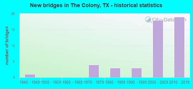
- New bridges - historical statistics
- 11940-1949
- 41970-1979
- 31980-1989
- 31990-1999
- 182000-2009
- 192010-2019
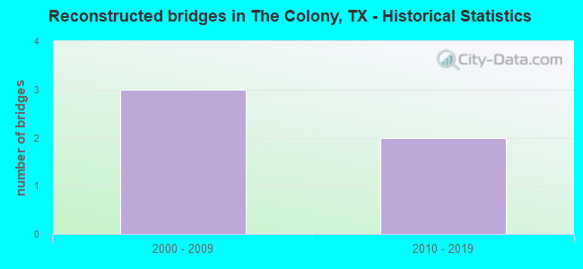
- Reconstructed bridges - Historical Statistics
- 32000-2009
- 22010-2019
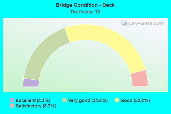
- Bridge Condition - Deck
- 4.3%Excellent
- 34.8%Very good
- 52.2%Good
- 8.7%Satisfactory
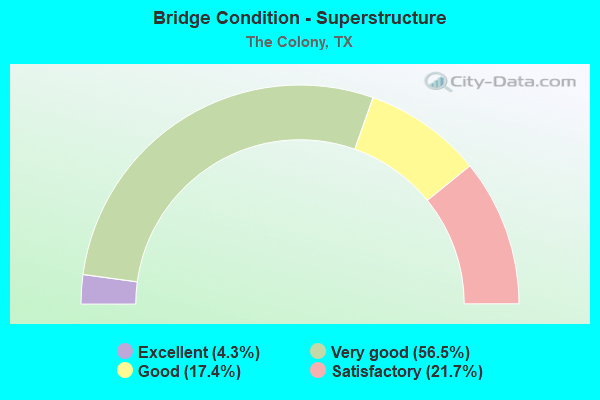
- Bridge Condition - Superstructure
- 4.3%Excellent
- 56.5%Very good
- 17.4%Good
- 21.7%Satisfactory
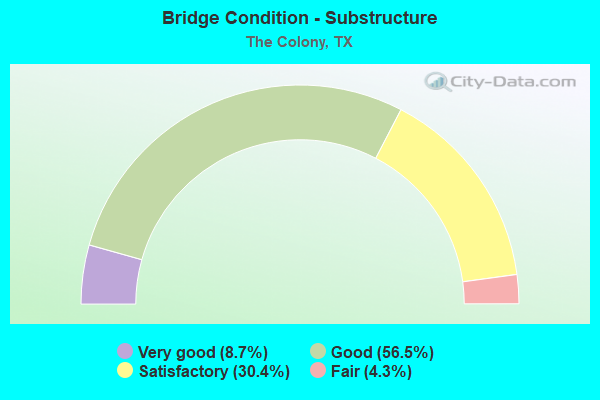
- Bridge Condition - Substructure
- 8.7%Very good
- 56.5%Good
- 30.4%Satisfactory
- 4.3%Fair
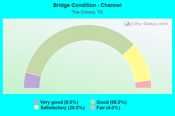
- Bridge Condition - Channel
- 8.0%Very good
- 68.0%Good
- 20.0%Satisfactory
- 4.0%Fair
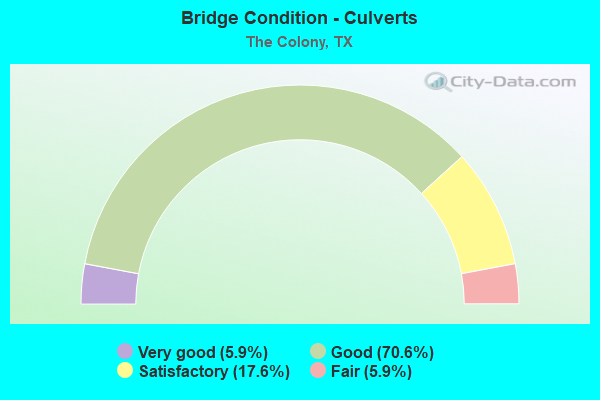
- Bridge Condition - Culverts
- 5.9%Very good
- 70.6%Good
- 17.6%Satisfactory
- 5.9%Fair
Find on map >> Show street view
Structure Number: 180610008103039, Location: 2.10 MI N OF FM 407 (Lat: 33.128942, Lng: -97.181083), Route carried "on" structure: US 377, Year Built: 1942, Status: Open, Structure Length: 1.13m (3.71ft), Average Daily Traffic: 6,879 (year 2020), Truck Traffic: 11%, Average Future Daily Traffic: 11,780 (year 2033), Design Load: H 15, Features Intersected: GRAVEYARD BRANCH DRAW
Minimum Vertical Clearance: 30+ m (98+ ft), Kilometerpoint: 5.134, Lanes on structure: 2, Owner: State Highway Agency, Approaching Roadway Width: 13.1m (43.0ft), Material/Design: Concrete, Design/Construction: Culvert, Number Of Spans In Main Unit: 5, Length of Maximum Span: 2.1m (6.9ft), Curb-To-Curb Width: 13.1m (43.0ft), Out-to-Out Width: 14.4m (47.2ft)
Condition: Channel: Satisfactory, Culverts: Good, Operating Rating: 32.7 metric tons, Method Used To Determine Operating Rating: Field evaluation and documented engineering judgment, Inventory Rating: 24.5 metric tons, Method Used To Determine Inventory Rating: Field evaluation and documented engineering judgment, Structural Evaluation: Equal to present minimum criteria, Deck Geometry: Somewhat better than minimum adequacy, Waterway Adequacy: Equal to present minimum criteria, Approach Roadway Alignment: Equal to present desirable criteria, Designated Inspection Frequency: Every 24 months, Inspection Date: August 2021, Deck Structure Type: Concrete Cast-file-Place, Wearing Surface/Protective System: Wearing Surface: Bituminous
Find on map >> Show street view
Structure Number: 180610036403124, Location: 2.20 MI NE OF FM 423 (Lat: 33.081150, Lng: -96.856081), Route carried "on" structure: ServiceState highway 121, Year Built: 2007, Status: Open, Structure Length: 8.17m (26.80ft), Average Daily Traffic: 18,530 (year 2011), Truck Traffic: 3%, Average Future Daily Traffic: 25,940 (year 2031), Design Load: HS 20, Features Intersected: BNSF RAILROAD
Minimum Vertical Clearance: 30+ m (98+ ft), Kilometerpoint: 2.916, Lanes on structure: 3, Owner: Local Toll Authority, Maintenance Responsibility: State Toll Authority, Approaching Roadway Width: 12.2m (40.0ft), Skew: 2 degrees, Material/Design: Prestressed concrete, Design/Construction: Stringer/Multi-beam, Number Of Spans In Main Unit: 2, Number Of Approach Spans: 1, Length of Maximum Span: 34.7m (113.8ft), Curb-To-Curb Width: 12.2m (40.0ft), Out-to-Out Width: 12.8m (42.0ft)
Condition: Deck: Good, Superstructure: Good, Substructure: Satisfactory, Operating Rating: 54.4 metric tons, Method Used To Determine Operating Rating: Assigned rating based on Load Factor Design (LFD) reported in metric tons, Inventory Rating: 32.7 metric tons, Method Used To Determine Inventory Rating: Assigned rating based on Load Factor Design (LFD) reported in metric tons, Structural Evaluation: Equal to present minimum criteria, Deck Geometry: Meets minimum limits, Underclear: Better than present minimum criteria, Approach Roadway Alignment: Equal to present desirable criteria, Designated Inspection Frequency: Every 24 months, Inspection Date: October 2021, Deck Structure Type: Concrete Precast Panels
Find on map >> Show street view
Structure Number: 180610036403125, Location: 2.20 MI NE OF FM 423 (Lat: 33.080853, Lng: -96.855144), Route carried "on" structure: ServiceState highway 121, Year Built: 2006, Status: Open, Structure Length: 8.17m (26.80ft), Average Daily Traffic: 18,530 (year 2011), Truck Traffic: 3%, Average Future Daily Traffic: 25,940 (year 2031), Design Load: HS 20, Features Intersected: BNSF RAILROAD
Minimum Vertical Clearance: 30+ m (98+ ft), Kilometerpoint: 2.950, Lanes on structure: 3, Owner: Local Toll Authority, Approaching Roadway Width: 12.2m (40.0ft), Skew: 2 degrees, Material/Design: Prestressed concrete, Design/Construction: Stringer/Multi-beam, Number Of Spans In Main Unit: 2, Number Of Approach Spans: 1, Length of Maximum Span: 34.7m (113.8ft), Curb-To-Curb Width: 12.2m (40.0ft), Out-to-Out Width: 12.8m (42.0ft)
Condition: Deck: Good, Superstructure: Good, Substructure: Satisfactory, Operating Rating: 54.4 metric tons, Method Used To Determine Operating Rating: Assigned rating based on Load Factor Design (LFD) reported in metric tons, Inventory Rating: 32.7 metric tons, Method Used To Determine Inventory Rating: Assigned rating based on Load Factor Design (LFD) reported in metric tons, Structural Evaluation: Equal to present minimum criteria, Deck Geometry: Meets minimum limits, Underclear: Equal to present minimum criteria, Approach Roadway Alignment: Equal to present desirable criteria, Designated Inspection Frequency: Every 24 months, Inspection Date: October 2021, Deck Structure Type: Concrete Precast Panels
Find on map >> Show street view
Structure Number: 180610036403126, Location: 2.20 MI NE OF FM 423 (Lat: 33.080533, Lng: -96.856131), Route carried "on" structure: Other road 121, Year Built: 2009, Status: Open, Structure Length: 8.66m (28.41ft), Average Daily Traffic: 25,000 (year 2013), Truck Traffic: 7%, Average Future Daily Traffic: 33,409 (year 2033), Design Load: HS 20, Features Intersected: BNSF RAILROAD, Facility Carried by Structure: SRT NBML
Minimum Vertical Clearance: 30+ m (98+ ft), Kilometerpoint: 2.974, Lanes on structure: 4, Toll: On toll road, Owner: Local Toll Authority, Approaching Roadway Width: 21.3m (69.9ft), Skew: 2 degrees, Material/Design: Prestressed concrete, Design/Construction: Stringer/Multi-beam, Number Of Spans In Main Unit: 2, Number Of Approach Spans: 1, Length of Maximum Span: 34.7m (113.8ft), Curb-To-Curb Width: 24.5m (80.4ft), Out-to-Out Width: 25.3m (83.0ft)
Condition: Deck: Good, Superstructure: Satisfactory, Substructure: Good, Operating Rating: 54.4 metric tons, Method Used To Determine Operating Rating: Assigned rating based on Load Factor Design (LFD) reported in metric tons, Inventory Rating: 32.7 metric tons, Method Used To Determine Inventory Rating: Assigned rating based on Load Factor Design (LFD) reported in metric tons, Structural Evaluation: Equal to present minimum criteria, Deck Geometry: Superior to present desirable criteria, Underclear: Equal to present desirable criteria, Approach Roadway Alignment: Equal to present desirable criteria, Designated Inspection Frequency: Every 24 months, Inspection Date: October 2021, Deck Structure Type: Concrete Precast Panels
Find on map >> Show street view
Structure Number: 180610036403127, Location: 2.20 MI NE OF FM 423 (Lat: 33.080831, Lng: -96.856069), Route carried "on" structure: Other road 121, Year Built: 2009, Status: Open, Structure Length: 8.66m (28.41ft), Average Daily Traffic: 25,000 (year 2013), Truck Traffic: 7%, Average Future Daily Traffic: 33,409 (year 2033), Design Load: HS 20, Features Intersected: BNSF RAILROAD, Facility Carried by Structure: SRT SBML
Minimum Vertical Clearance: 30+ m (98+ ft), Kilometerpoint: 2.974, Lanes on structure: 4, Toll: On toll road, Owner: Local Toll Authority, Approaching Roadway Width: 21.3m (69.9ft), Skew: 2 degrees, Material/Design: Prestressed concrete, Design/Construction: Stringer/Multi-beam, Number Of Spans In Main Unit: 2, Number Of Approach Spans: 1, Length of Maximum Span: 34.7m (113.8ft), Curb-To-Curb Width: 24.5m (80.4ft), Out-to-Out Width: 25.3m (83.0ft)
Condition: Deck: Good, Superstructure: Very good, Substructure: Satisfactory, Operating Rating: 54.4 metric tons, Method Used To Determine Operating Rating: Assigned rating based on Load Factor Design (LFD) reported in metric tons, Inventory Rating: 32.7 metric tons, Method Used To Determine Inventory Rating: Assigned rating based on Load Factor Design (LFD) reported in metric tons, Structural Evaluation: Equal to present minimum criteria, Deck Geometry: Superior to present desirable criteria, Underclear: Superior to present desirable criteria, Approach Roadway Alignment: Equal to present desirable criteria, Designated Inspection Frequency: Every 24 months, Inspection Date: October 2021, Deck Structure Type: Concrete Precast Panels
Find on map >> Show street view
Structure Number: 180610036403128, Location: 0.85 MI NE OF FM 423 (Lat: 33.071292, Lng: -96.876503), Route carried "on" structure: Other road 121, Year Built: 2009, Status: Open, Structure Length: 9.54m (31.30ft), Average Daily Traffic: 25,000 (year 2013), Truck Traffic: 7%, Average Future Daily Traffic: 33,409 (year 2033), Design Load: HS 20, Features Intersected: PLANO PKWY / PAIGE RD, Facility Carried by Structure: SRT NBML
Minimum Vertical Clearance: 30+ m (98+ ft), Kilometerpoint: 16.824, Lanes on structure: 4, Lanes under structure: 9, Toll: On toll road, Owner: Local Toll Authority, Approaching Roadway Width: 21.3m (69.9ft), Material/Design: Prestressed concrete, Design/Construction: Stringer/Multi-beam, Number Of Spans In Main Unit: 1, Number Of Approach Spans: 2, Length of Maximum Span: 39.3m (128.9ft), Curb-To-Curb Width: 24.5m (80.4ft), Out-to-Out Width: 25.3m (83.0ft)
Condition: Deck: Very good, Superstructure: Good, Substructure: Good, Operating Rating: 54.4 metric tons, Method Used To Determine Operating Rating: Assigned rating based on Load Factor Design (LFD) reported in metric tons, Inventory Rating: 32.7 metric tons, Method Used To Determine Inventory Rating: Assigned rating based on Load Factor Design (LFD) reported in metric tons, Structural Evaluation: Better than present minimum criteria, Deck Geometry: Superior to present desirable criteria, Underclear: Meets minimum limits, Approach Roadway Alignment: Equal to present desirable criteria, Designated Inspection Frequency: Every 24 months, Inspection Date: October 2021, Deck Structure Type: Concrete Precast Panels
Find on map >> Show street view
Structure Number: 180610036403129, Location: 0.85 MI NE OF FM 423 (Lat: 33.071514, Lng: -96.876642), Route carried "on" structure: Other road 121, Year Built: 2009, Status: Open, Structure Length: 9.54m (31.30ft), Average Daily Traffic: 25,000 (year 2013), Truck Traffic: 7%, Average Future Daily Traffic: 33,409 (year 2033), Design Load: HS 20, Features Intersected: PLANO PKWY / PAIGE RD, Facility Carried by Structure: SRT SBML
Minimum Vertical Clearance: 30+ m (98+ ft), Kilometerpoint: 16.824, Lanes on structure: 4, Lanes under structure: 9, Toll: On toll road, Owner: Local Toll Authority, Approaching Roadway Width: 21.3m (69.9ft), Material/Design: Prestressed concrete, Design/Construction: Stringer/Multi-beam, Number Of Spans In Main Unit: 1, Number Of Approach Spans: 2, Length of Maximum Span: 39.3m (128.9ft), Curb-To-Curb Width: 24.5m (80.4ft), Out-to-Out Width: 25.3m (83.0ft)
Condition: Deck: Satisfactory, Superstructure: Satisfactory, Substructure: Fair, Operating Rating: 54.4 metric tons, Method Used To Determine Operating Rating: Assigned rating based on Load Factor Design (LFD) reported in metric tons, Inventory Rating: 32.7 metric tons, Method Used To Determine Inventory Rating: Assigned rating based on Load Factor Design (LFD) reported in metric tons, Structural Evaluation: Somewhat better than minimum adequacy, Deck Geometry: Superior to present desirable criteria, Underclear: Meets minimum limits, Approach Roadway Alignment: Equal to present desirable criteria, Designated Inspection Frequency: Every 24 months, Inspection Date: October 2021, Deck Structure Type: Concrete Precast Panels
Find on map >> Show street view
Structure Number: 18061003640313, Location: 2.40 MI NE OF FM 423 (Lat: 33.082136, Lng: -96.852556), Route carried "on" structure: Other road 121, Year Built: 2009, Status: Open, Structure Length: 9.24m (30.31ft), Average Daily Traffic: 25,000 (year 2013), Truck Traffic: 7%, Average Future Daily Traffic: 33,409 (year 2033), Design Load: HS 20, Features Intersected: SPRING CREEK PARKWAY, Facility Carried by Structure: SRT NBML
Minimum Vertical Clearance: 30+ m (98+ ft), Kilometerpoint: 13.036, Lanes on structure: 4, Lanes under structure: 10, Toll: On toll road, Owner: Local Toll Authority, Approaching Roadway Width: 21.3m (69.9ft), Skew: 9 degrees, Material/Design: Prestressed concrete, Design/Construction: Stringer/Multi-beam, Number Of Spans In Main Unit: 1, Number Of Approach Spans: 2, Length of Maximum Span: 39.3m (128.9ft), Curb-To-Curb Width: 25.5m (83.7ft), Out-to-Out Width: 26.2m (86.0ft)
Condition: Deck: Good, Superstructure: Satisfactory, Substructure: Satisfactory, Operating Rating: 54.4 metric tons, Method Used To Determine Operating Rating: Assigned rating based on Load Factor Design (LFD) reported in metric tons, Inventory Rating: 32.7 metric tons, Method Used To Determine Inventory Rating: Assigned rating based on Load Factor Design (LFD) reported in metric tons, Structural Evaluation: Equal to present minimum criteria, Deck Geometry: Superior to present desirable criteria, Underclear: Superior to present desirable criteria, Approach Roadway Alignment: Equal to present desirable criteria, Designated Inspection Frequency: Every 24 months, Inspection Date: October 2021, Deck Structure Type: Concrete Precast Panels
Find on map >> Show street view
Structure Number: 180610036403174, Location: 0.80 MI NE OF FM 423 (Lat: 33.070892, Lng: -96.876450), Route carried "on" structure: State highway 121, Year Built: 2006, Status: Open, Structure Length: 1.07m (3.51ft), Average Daily Traffic: 76,750 (year 2011), Truck Traffic: 6%, Average Future Daily Traffic: 145,830 (year 2031), Design Load: HS 20, Features Intersected: DRAIN
Minimum Vertical Clearance: 30+ m (98+ ft), Kilometerpoint: 5.203, Lanes on structure: 16, Owner: Local Toll Authority, Approaching Roadway Width: 73.2m (240.2ft), Skew: 30 degrees, Material/Design: Concrete, Design/Construction: Culvert, Number Of Spans In Main Unit: 4, Length of Maximum Span: 2.4m (7.9ft)
Condition: Channel: Good, Culverts: Good, Operating Rating: 54.4 metric tons, Method Used To Determine Operating Rating: Assigned rating based on Load Factor Design (LFD) reported in metric tons, Inventory Rating: 32.7 metric tons, Method Used To Determine Inventory Rating: Assigned rating based on Load Factor Design (LFD) reported in metric tons, Structural Evaluation: Better than present minimum criteria, Waterway Adequacy: Superior to present desirable criteria, Approach Roadway Alignment: Equal to present desirable criteria, Designated Inspection Frequency: Every 24 months, Inspection Date: April 2021
Find on map >> Show street view
Structure Number: 180610036403175, Location: 1.20 MI NE OF FM 423 (Lat: 33.073308, Lng: -96.871397), Route carried "on" structure: State highway 121, Year Built: 2007, Year Reconstructed: 2015, Status: Open, Structure Length: 1.04m (3.41ft), Average Daily Traffic: 76,750 (year 2011), Truck Traffic: 6%, Average Future Daily Traffic: 145,830 (year 2031), Design Load: HS 20, Features Intersected: DRAIN
Minimum Vertical Clearance: 30+ m (98+ ft), Kilometerpoint: 4.640, Lanes on structure: 14, Owner: Local Toll Authority, Approaching Roadway Width: 65.8m (215.9ft), Skew: 1 degrees, Material/Design: Concrete, Design/Construction: Culvert, Number Of Spans In Main Unit: 3, Length of Maximum Span: 3.0m (9.8ft)
Condition: Channel: Good, Culverts: Good, Operating Rating: 54.4 metric tons, Method Used To Determine Operating Rating: Assigned rating based on Load Factor Design (LFD) reported in metric tons, Inventory Rating: 32.7 metric tons, Method Used To Determine Inventory Rating: Assigned rating based on Load Factor Design (LFD) reported in metric tons, Structural Evaluation: Better than present minimum criteria, Waterway Adequacy: Superior to present desirable criteria, Approach Roadway Alignment: Equal to present desirable criteria, Designated Inspection Frequency: Every 24 months, Inspection Date: April 2021
Find on map >> Show street view
Structure Number: 180610036403692, Location: 0.02 MI NE of S COLONY (Lat: 33.077083, Lng: -96.865100), Route carried "on" structure: Ramp State highway 121, Year Built: 2015, Status: Open, Structure Length: 7.38m (24.21ft), Average Daily Traffic: 3,500 (year 2020), Truck Traffic: 3%, Average Future Daily Traffic: 4,900 (year 2040), Design Load: HL 93, Features Intersected: SH 121 SB On-Ramp, Facility Carried by Structure: Colony Blvd N CONN
Minimum Vertical Clearance: 30+ m (98+ ft), Kilometerpoint: 91.050, Lanes on structure: 2, Lanes under structure: 1, Owner: Local Toll Authority, Approaching Roadway Width: 13.4m (44.0ft), Material/Design: Prestressed concrete, Design/Construction: Stringer/Multi-beam, Number Of Spans In Main Unit: 3, Length of Maximum Span: 26.2m (86.0ft), Curb-To-Curb Width: 13.3m (43.6ft), Out-to-Out Width: 14.0m (45.9ft)
Condition: Deck: Very good, Superstructure: Very good, Substructure: Good, Operating Rating: 54.4 metric tons, Method Used To Determine Operating Rating: Assigned ratings based on Load and Resistance Factor Design (LRFD) reported in metric tons, Inventory Rating: 32.7 metric tons, Method Used To Determine Inventory Rating: Assigned ratings based on Load and Resistance Factor Design (LRFD) reported in metric tons, Structural Evaluation: Better than present minimum criteria, Deck Geometry: Superior to present desirable criteria, Underclear: Equal to present minimum criteria, Approach Roadway Alignment: Equal to present desirable criteria, Designated Inspection Frequency: Every 24 months, Inspection Date: August 2020, Deck Structure Type: Concrete Precast Panels, Wearing Surface/Protective System: Deck Protection: Epoxy Coated Reinforcing
Find on map >> Show street view
Structure Number: 180610036403693, Location: 0.02 MI NE of S COLONY (Lat: 33.076561, Lng: -96.864789), Route carried "on" structure: Ramp State highway 121, Year Built: 2015, Status: Open, Structure Length: 4.30m (14.11ft), Average Daily Traffic: 3,000 (year 2020), Truck Traffic: 3%, Average Future Daily Traffic: 4,200 (year 2040), Design Load: HL 93, Features Intersected: SH 121 NB Exit Ramp, Facility Carried by Structure: Colony Blvd E CONN
Minimum Vertical Clearance: 30+ m (98+ ft), Kilometerpoint: 91.050, Lanes on structure: 2, Lanes under structure: 1, Owner: Local Toll Authority, Approaching Roadway Width: 9.8m (32.2ft), Material/Design: Prestressed concrete, Design/Construction: Stringer/Multi-beam, Number Of Spans In Main Unit: 1, Number Of Approach Spans: 1, Length of Maximum Span: 25.9m (85.0ft), Curb-To-Curb Width: 9.7m (31.8ft), Out-to-Out Width: 10.4m (34.1ft)
Condition: Deck: Very good, Superstructure: Very good, Substructure: Good, Operating Rating: 54.4 metric tons, Method Used To Determine Operating Rating: Assigned ratings based on Load and Resistance Factor Design (LRFD) reported in metric tons, Inventory Rating: 32.7 metric tons, Method Used To Determine Inventory Rating: Assigned ratings based on Load and Resistance Factor Design (LRFD) reported in metric tons, Structural Evaluation: Better than present minimum criteria, Deck Geometry: Somewhat better than minimum adequacy, Underclear: Somewhat better than minimum adequacy, Approach Roadway Alignment: Somewhat better than minimum adequacy, Designated Inspection Frequency: Every 24 months, Inspection Date: August 2020, Deck Structure Type: Concrete Precast Panels, Wearing Surface/Protective System: Deck Protection: Epoxy Coated Reinforcing
Find on map >> Show street view
Structure Number: 180610036403694, Location: AT JCT SH 121/ S COLONY (Lat: 33.076489, Lng: -96.865439), Route carried "on" structure: City street , Year Built: 2016, Status: Open, Structure Length: 16.25m (53.31ft), Average Daily Traffic: 7,500 (year 2020), Truck Traffic: 3%, Average Future Daily Traffic: 12,000 (year 2040), Design Load: HL 93, Features Intersected: SH 121, Facility Carried by Structure: S Colony Blvd
Minimum Vertical Clearance: 30+ m (98+ ft), Kilometerpoint: 0.000, Lanes on structure: 4, Lanes under structure: 12, Owner: Local Toll Authority, Approaching Roadway Width: 20.1m (65.9ft), Skew: 30 degrees, Material/Design: Prestressed concrete, Design/Construction: Stringer/Multi-beam, Number Of Spans In Main Unit: 6, Number Of Approach Spans: 2, Length of Maximum Span: 23.5m (77.1ft), Curb or Sidewalk Widths: Left: 2.0m (6.6ft), Right: 2.6m (8.5ft), Curb-To-Curb Width: 19.9m (65.3ft), Out-to-Out Width: 33.8m (110.9ft)
Condition: Deck: Very good, Superstructure: Very good, Substructure: Good, Operating Rating: 54.4 metric tons, Method Used To Determine Operating Rating: Assigned ratings based on Load and Resistance Factor Design (LRFD) reported in metric tons, Inventory Rating: 32.7 metric tons, Method Used To Determine Inventory Rating: Assigned ratings based on Load and Resistance Factor Design (LRFD) reported in metric tons, Structural Evaluation: Better than present minimum criteria, Deck Geometry: Better than present minimum criteria, Underclear: High priority of corrective action, Approach Roadway Alignment: Equal to present desirable criteria, Designated Inspection Frequency: Every 24 months, Inspection Date: August 2020, Deck Structure Type: Concrete Cast-file-Place, Wearing Surface/Protective System: Deck Protection: Epoxy Coated Reinforcing
Find on map >> Show street view
Structure Number: 180610036403695, Location: 0.02 MI SW of S COLONY (Lat: 33.076431, Lng: -96.866500), Route carried "on" structure: Ramp State highway 121, Year Built: 2015, Status: Open, Structure Length: 12.19m (39.99ft), Average Daily Traffic: 3,500 (year 2020), Truck Traffic: 3%, Average Future Daily Traffic: 4,900 (year 2040), Design Load: HL 93, Features Intersected: SH 121 SB On-Ramp, Facility Carried by Structure: Colony Blvd W CONN
Minimum Vertical Clearance: 30+ m (98+ ft), Kilometerpoint: 90.857, Lanes on structure: 3, Lanes under structure: 1, Owner: Local Toll Authority, Approaching Roadway Width: 13.4m (44.0ft), Material/Design: Prestressed concrete, Design/Construction: Stringer/Multi-beam, Number Of Spans In Main Unit: 4, Number Of Approach Spans: 1, Length of Maximum Span: 17.1m (56.1ft), Curb-To-Curb Width: 13.3m (43.6ft), Out-to-Out Width: 14.0m (45.9ft)
Condition: Deck: Very good, Superstructure: Very good, Substructure: Good, Operating Rating: 54.4 metric tons, Method Used To Determine Operating Rating: Assigned ratings based on Load and Resistance Factor Design (LRFD) reported in metric tons, Inventory Rating: 32.7 metric tons, Method Used To Determine Inventory Rating: Assigned ratings based on Load and Resistance Factor Design (LRFD) reported in metric tons, Structural Evaluation: Better than present minimum criteria, Deck Geometry: Somewhat better than minimum adequacy, Underclear: Somewhat better than minimum adequacy, Approach Roadway Alignment: Equal to present desirable criteria, Designated Inspection Frequency: Every 24 months, Inspection Date: August 2020, Deck Structure Type: Concrete Precast Panels, Wearing Surface/Protective System: Deck Protection: Epoxy Coated Reinforcing
Find on map >> Show street view
Structure Number: 180610156702009, Location: 3.05 MI N OF SH 121 (Lat: 33.109867, Lng: -96.891925), Route carried "on" structure: State highway 423, Year Built: 1987, Year Reconstructed: 2017, Status: Open, Structure Length: 7.32m (24.02ft), Average Daily Traffic: 15,156 (year 2017), Truck Traffic: 7%, Average Future Daily Traffic: 36,270 (year 2033), Design Load: HS 20, Features Intersected: STEWART CREEK
Minimum Vertical Clearance: 30+ m (98+ ft), Kilometerpoint: 4.862, Lanes on structure: 3, Owner: State Highway Agency, Approaching Roadway Width: 11.6m (38.1ft), Material/Design: Prestressed concrete, Design/Construction: Stringer/Multi-beam, Number Of Spans In Main Unit: 3, Length of Maximum Span: 24.4m (80.1ft), Curb-To-Curb Width: 16.5m (54.1ft), Out-to-Out Width: 21.3m (69.9ft)
Condition: Deck: Good, Superstructure: Very good, Substructure: Good, Channel: Good, Operating Rating: 54.4 metric tons, Method Used To Determine Operating Rating: Assigned rating based on Load Factor Design (LFD) reported in metric tons, Inventory Rating: 32.7 metric tons, Method Used To Determine Inventory Rating: Assigned rating based on Load Factor Design (LFD) reported in metric tons, Structural Evaluation: Better than present minimum criteria, Deck Geometry: Better than present minimum criteria, Waterway Adequacy: Equal to present desirable criteria, Approach Roadway Alignment: Equal to present desirable criteria, Designated Inspection Frequency: Every 24 months, Inspection Date: September 2021, Deck Structure Type: Concrete Cast-file-Place
Find on map >> Show street view
Structure Number: 180610156702021, Location: 3.05 Mi N of SH 121 (Lat: 33.109119, Lng: -96.891800), Route carried "on" structure: State highway 423, Year Built: 2015, Status: Open, Structure Length: 7.32m (24.02ft), Average Daily Traffic: 15,799 (year 2017), Truck Traffic: 10%, Average Future Daily Traffic: 77,600 (year 2033), Design Load: HL 93, Features Intersected: STEWART CREEK
Minimum Vertical Clearance: 30+ m (98+ ft), Kilometerpoint: 4.862, Lanes on structure: 3, Owner: State Highway Agency, Approaching Roadway Width: 11.6m (38.1ft), Material/Design: Prestressed concrete, Design/Construction: Stringer/Multi-beam, Number Of Spans In Main Unit: 3, Length of Maximum Span: 24.4m (80.1ft), Curb-To-Curb Width: 15.9m (52.2ft), Out-to-Out Width: 16.5m (54.1ft)
Condition: Deck: Good, Superstructure: Very good, Substructure: Good, Channel: Very good, Operating Rating: 54.4 metric tons, Method Used To Determine Operating Rating: Assigned ratings based on Load and Resistance Factor Design (LRFD) reported in metric tons, Inventory Rating: 32.7 metric tons, Method Used To Determine Inventory Rating: Assigned ratings based on Load and Resistance Factor Design (LRFD) reported in metric tons, Structural Evaluation: Better than present minimum criteria, Deck Geometry: Better than present minimum criteria, Waterway Adequacy: Equal to present desirable criteria, Approach Roadway Alignment: Equal to present desirable criteria, Designated Inspection Frequency: Every 24 months, Inspection Date: September 2021, Deck Structure Type: Concrete Cast-file-Place
Find on map >> Show street view
Structure Number: 180610156702023, Location: 1.40 MI N OF SH 121 (Lat: 33.084964, Lng: -96.892878), Route carried "on" structure: State highway , Year Built: 2016, Status: Open, Structure Length: 2.01m (6.59ft), Average Daily Traffic: 48,980 (year 2019), Truck Traffic: 1%, Average Future Daily Traffic: 95,021 (year 2039), Design Load: HL 93, Features Intersected: DRAW, Facility Carried by Structure: FM 423 (MAIN ST)
Minimum Vertical Clearance: 30+ m (98+ ft), Kilometerpoint: 7.640, Lanes on structure: 6, Owner: State Highway Agency, Approaching Roadway Width: 23.8m (78.1ft), Skew: 24 degrees, Material/Design: Concrete, Design/Construction: Culvert, Number Of Spans In Main Unit: 4, Length of Maximum Span: 3.0m (9.8ft), Curb or Sidewalk Widths: Left: 3.0m (9.8ft), Right: 1.5m (4.9ft), Curb-To-Curb Width: 23.8m (78.1ft), Out-to-Out Width: 46.6m (152.9ft)
Condition: Channel: Very good, Culverts: Good, Operating Rating: 54.4 metric tons, Method Used To Determine Operating Rating: Assigned ratings based on Load and Resistance Factor Design (LRFD) reported in metric tons, Inventory Rating: 32.7 metric tons, Method Used To Determine Inventory Rating: Assigned ratings based on Load and Resistance Factor Design (LRFD) reported in metric tons, Structural Evaluation: Better than present minimum criteria, Deck Geometry: Somewhat better than minimum adequacy, Waterway Adequacy: Superior to present desirable criteria, Approach Roadway Alignment: Equal to present desirable criteria, Designated Inspection Frequency: Every 24 months, Inspection Date: October 2020, Deck Structure Type: Concrete Cast-file-Place, Wearing Surface/Protective System: Wearing Surface: Monolithic Concrete
Find on map >> Show street view
Structure Number: 180610156702024, Location: 0.45 MI N OF SH 121 (Lat: 33.071717, Lng: -96.892358), Route carried "on" structure: State highway 423, Year Built: 2017, Status: Open, Structure Length: 1.52m (4.99ft), Average Daily Traffic: 49,600 (year 2007), Truck Traffic: 23%, Average Future Daily Traffic: 77,600 (year 2027), Design Load: HL 93, Features Intersected: OFFICE BRANCH
Minimum Vertical Clearance: 30+ m (98+ ft), Kilometerpoint: 9.117, Lanes on structure: 8, Owner: State Highway Agency, Approaching Roadway Width: 32.0m (105.0ft), Skew: 31 degrees, Material/Design: Concrete, Design/Construction: Culvert, Number Of Spans In Main Unit: 4, Length of Maximum Span: 3.0m (9.8ft), Curb or Sidewalk Widths: Left: 2.4m (7.9ft), Right: 4.0m (13.1ft)
Condition: Channel: Satisfactory, Culverts: Good, Operating Rating: 54.4 metric tons, Method Used To Determine Operating Rating: Assigned ratings based on Load and Resistance Factor Design (LRFD) reported in metric tons, Inventory Rating: 32.7 metric tons, Method Used To Determine Inventory Rating: Assigned ratings based on Load and Resistance Factor Design (LRFD) reported in metric tons, Structural Evaluation: Better than present minimum criteria, Waterway Adequacy: Superior to present desirable criteria, Approach Roadway Alignment: Equal to present desirable criteria, Designated Inspection Frequency: Every 24 months, Inspection Date: November 2021
Find on map >> Show street view
Structure Number: 180610J00250003, Location: 1.9 MI E OF FM 423 (Lat: 33.119872, Lng: -96.863342), Route carried "on" structure: City street , Year Built: 2009, Status: Open, Structure Length: 11.67m (38.29ft), Average Daily Traffic: 1,000 (year 2011), Truck Traffic: 2%, Average Future Daily Traffic: 2,000 (year 2031), Features Intersected: STEWART CREEK, Facility Carried by Structure: LEBANON RD EB
Minimum Vertical Clearance: 30+ m (98+ ft), Kilometerpoint: 2.977, Lanes on structure: 2, Owner: City or Municipal Highway Agency, Approaching Roadway Width: 7.3m (24.0ft), Skew: 9 degrees, Material/Design: Prestressed concrete, Design/Construction: Stringer/Multi-beam, Number Of Spans In Main Unit: 5, Length of Maximum Span: 24.1m (79.1ft), Curb or Sidewalk Widths: Left: 0.0m, Right: 1.9m (6.2ft), Curb-To-Curb Width: 11.3m (37.1ft), Out-to-Out Width: 14.0m (45.9ft)
Condition: Deck: Good, Superstructure: Very good, Substructure: Good, Channel: Good, Operating Rating: 32.7 metric tons, Method Used To Determine Operating Rating: Field evaluation and documented engineering judgment, Inventory Rating: 24.5 metric tons, Method Used To Determine Inventory Rating: Field evaluation and documented engineering judgment, Structural Evaluation: Equal to present minimum criteria, Deck Geometry: Equal to present minimum criteria, Waterway Adequacy: Superior to present desirable criteria, Approach Roadway Alignment: Equal to present desirable criteria, Designated Inspection Frequency: Every 24 months, Inspection Date: December 2020, Deck Structure Type: Concrete Precast Panels, Wearing Surface/Protective System: Deck Protection: Epoxy Coated Reinforcing
Find on map >> Show street view
Structure Number: 180610LX5229001, Location: 0.30 MI N OF MEMORIAL DR (Lat: 33.068478, Lng: -96.899847), Route carried "on" structure: City street , Year Built: 1985, Status: Open, Structure Length: 1.98m (6.50ft), Average Daily Traffic: 186 (year 2019), Truck Traffic: 3%, Average Future Daily Traffic: 186 (year 2039), Features Intersected: OFFICE CREEK, Facility Carried by Structure: STANDRIDGE DR
Minimum Vertical Clearance: 30+ m (98+ ft), Kilometerpoint: 0.483, Lanes on structure: 2, Owner: City or Municipal Highway Agency, Approaching Roadway Width: 11.0m (36.1ft), Material/Design: Concrete, Design/Construction: Culvert, Number Of Spans In Main Unit: 6, Length of Maximum Span: 3.0m (9.8ft), Curb or Sidewalk Widths: Left: 0.0m, Right: 1.2m (3.9ft), Curb-To-Curb Width: 11.0m (36.1ft), Out-to-Out Width: 33.2m (108.9ft)
Condition: Channel: Satisfactory, Culverts: Good, Operating Rating: 32.7 metric tons, Method Used To Determine Operating Rating: Field evaluation and documented engineering judgment, Inventory Rating: 24.5 metric tons, Method Used To Determine Inventory Rating: Field evaluation and documented engineering judgment, Structural Evaluation: Equal to present minimum criteria, Deck Geometry: Equal to present desirable criteria, Waterway Adequacy: Better than present minimum criteria, Approach Roadway Alignment: Equal to present desirable criteria, Designated Inspection Frequency: Every 24 months, Inspection Date: October 2020, Deck Structure Type: Concrete Cast-file-Place, Wearing Surface/Protective System: Wearing Surface: Monolithic Concrete
Find on map >> Show street view
Structure Number: 180610MM0080001, Location: 0.06 MI N OF MEMORIAL DR (Lat: 33.071314, Lng: -96.885892), Route carried "on" structure: City street , Year Built: 2005, Status: Open, Structure Length: 1.31m (4.30ft), Average Daily Traffic: 4,990 (year 2011), Truck Traffic: 7%, Average Future Daily Traffic: 6,000 (year 2031), Design Load: HS 20, Features Intersected: OFFICE CREEK, Facility Carried by Structure: BLAIR OAKS DR
Minimum Vertical Clearance: 30+ m (98+ ft), Kilometerpoint: 0.097, Lanes on structure: 2, Owner: City or Municipal Highway Agency, Approaching Roadway Width: 11.0m (36.1ft), Material/Design: Concrete, Design/Construction: Culvert, Number Of Spans In Main Unit: 4, Length of Maximum Span: 3.0m (9.8ft), Curb or Sidewalk Widths: Left: 1.5m (4.9ft), Right: 0.0m, Curb-To-Curb Width: 10.9m (35.8ft), Out-to-Out Width: 23.2m (76.1ft)
Condition: Channel: Good, Culverts: Satisfactory, Operating Rating: 54.4 metric tons, Method Used To Determine Operating Rating: Assigned rating based on Load Factor Design (LFD) reported in metric tons, Inventory Rating: 32.7 metric tons, Method Used To Determine Inventory Rating: Assigned rating based on Load Factor Design (LFD) reported in metric tons, Structural Evaluation: Equal to present minimum criteria, Deck Geometry: Somewhat better than minimum adequacy, Waterway Adequacy: Equal to present minimum criteria, Approach Roadway Alignment: Equal to present desirable criteria, Designated Inspection Frequency: Every 24 months, Inspection Date: December 2020, Deck Structure Type: Concrete Cast-file-Place, Wearing Surface/Protective System: Wearing Surface: Monolithic Concrete
Find on map >> Show street view
Structure Number: 180610MM0115001, Location: 0.55 MI E OF FM 423 (Lat: 33.096581, Lng: -96.882486), Route carried "on" structure: City street , Year Built: 2011, Status: Open, Structure Length: 1.10m (3.61ft), Average Daily Traffic: 10,691 (year 2017), Truck Traffic: 7%, Average Future Daily Traffic: 23,000 (year 2037), Design Load: HL 93, Features Intersected: STONEBRIAR CREEK TRIB, Facility Carried by Structure: N COLONY BLVD
Minimum Vertical Clearance: 30+ m (98+ ft), Kilometerpoint: 2.977, Lanes on structure: 4, Owner: City or Municipal Highway Agency, Approaching Roadway Width: 17.7m (58.1ft), Material/Design: Concrete, Design/Construction: Culvert, Number Of Spans In Main Unit: 3, Length of Maximum Span: 3.0m (9.8ft), Curb or Sidewalk Widths: Left: 3.0m (9.8ft), Right: 3.0m (9.8ft)
Condition: Channel: Good, Culverts: Good, Operating Rating: 54.4 metric tons, Method Used To Determine Operating Rating: Assigned ratings based on Load and Resistance Factor Design (LRFD) reported in metric tons, Inventory Rating: 32.7 metric tons, Method Used To Determine Inventory Rating: Assigned ratings based on Load and Resistance Factor Design (LRFD) reported in metric tons, Structural Evaluation: Better than present minimum criteria, Waterway Adequacy: Superior to present desirable criteria, Approach Roadway Alignment: Equal to present desirable criteria, Designated Inspection Frequency: Every 24 months, Inspection Date: December 2020
Find on map >> Show street view
Structure Number: 180610MM0115002, Location: 0.90 MI E OF PAIGE RD (Lat: 33.095419, Lng: -96.860692), Route carried "on" structure: City street , Year Built: 1985, Status: Open, Structure Length: 0.98m (3.22ft), Average Daily Traffic: 3,780 (year 2013), Average Future Daily Traffic: 6,891 (year 2035), Features Intersected: STONEBRIAR CREEK TRIB, Facility Carried by Structure: N COLONY BLVD
Minimum Vertical Clearance: 30+ m (98+ ft), Kilometerpoint: 5.150, Lanes on structure: 4, Owner: City or Municipal Highway Agency, Approaching Roadway Width: 14.6m (47.9ft), Skew: 29 degrees, Material/Design: Concrete, Design/Construction: Culvert, Number Of Spans In Main Unit: 3, Length of Maximum Span: 2.7m (8.9ft), Curb or Sidewalk Widths: Left: 1.2m (3.9ft), Right: 1.2m (3.9ft)
Condition: Channel: Good, Culverts: Satisfactory, Operating Rating: 32.7 metric tons, Method Used To Determine Operating Rating: Field evaluation and documented engineering judgment, Inventory Rating: 24.5 metric tons, Method Used To Determine Inventory Rating: Field evaluation and documented engineering judgment, Structural Evaluation: Equal to present minimum criteria, Waterway Adequacy: Superior to present desirable criteria, Approach Roadway Alignment: Equal to present desirable criteria, Designated Inspection Frequency: Every 24 months, Inspection Date: December 2020
Find on map >> Show street view
Structure Number: 180610MM0225001, Location: 0.25 MI S OF SLAY DR (Lat: 33.093333, Lng: -96.878619), Route carried "on" structure: City street , Year Built: 1979, Status: Open, Structure Length: 0.67m (2.20ft), Average Daily Traffic: 900 (year 2013), Truck Traffic: 5%, Average Future Daily Traffic: 1,700 (year 2035), Design Load: HS 20, Features Intersected: STONEBRIAR CREEK TRIB, Facility Carried by Structure: MILLER DR
Minimum Vertical Clearance: 30+ m (98+ ft), Kilometerpoint: 0.402, Lanes on structure: 2, Owner: City or Municipal Highway Agency, Approaching Roadway Width: 7.9m (25.9ft), Material/Design: Concrete, Design/Construction: Culvert, Number Of Spans In Main Unit: 2, Length of Maximum Span: 3.0m (9.8ft), Curb or Sidewalk Widths: Left: 2.9m (9.5ft), Right: 0.0m
Condition: Channel: Good, Culverts: Satisfactory, Operating Rating: 39.9 metric tons, Method Used To Determine Operating Rating: Load Factor (LF), Inventory Rating: 23.6 metric tons, Method Used To Determine Inventory Rating: Load Factor (LF), Structural Evaluation: Equal to present minimum criteria, Waterway Adequacy: Better than present minimum criteria, Approach Roadway Alignment: Equal to present desirable criteria, Designated Inspection Frequency: Every 24 months, Inspection Date: December 2020
Find on map >> Show street view
Structure Number: 180610MM0245001, Location: 0.40 MI S N COLONY BLVD (Lat: 33.092881, Lng: -96.875583), Route carried "on" structure: City street , Year Built: 2008, Status: Open, Structure Length: 0.88m (2.89ft), Average Daily Traffic: 16,500 (year 2013), Average Future Daily Traffic: 26,262 (year 2035), Features Intersected: STONEBRIAR CREEK TRIB, Facility Carried by Structure: PAIGE RD
Minimum Vertical Clearance: 30+ m (98+ ft), Kilometerpoint: 0.660, Lanes on structure: 6, Owner: City or Municipal Highway Agency, Approaching Roadway Width: 20.1m (65.9ft), Skew: 20 degrees, Material/Design: Concrete, Design/Construction: Culvert, Number Of Spans In Main Unit: 3, Length of Maximum Span: 2.7m (8.9ft), Curb or Sidewalk Widths: Left: 2.7m (8.9ft), Right: 2.7m (8.9ft), Curb-To-Curb Width: 20.1m (65.9ft), Out-to-Out Width: 31.1m (102.0ft)
Condition: Channel: Good, Culverts: Good, Operating Rating: 32.7 metric tons, Method Used To Determine Operating Rating: Field evaluation and documented engineering judgment, Inventory Rating: 24.5 metric tons, Method Used To Determine Inventory Rating: Field evaluation and documented engineering judgment, Structural Evaluation: Equal to present minimum criteria, Deck Geometry: High priority of replacement, Waterway Adequacy: Equal to present minimum criteria, Approach Roadway Alignment: Better than present minimum criteria, Length Of Structure Improvement: 0.67m (2.20ft), Designated Inspection Frequency: Every 24 months, Inspection Date: December 2020, Bridge Improvement Cost: $21,000, Roadway Improvement Cost: $5,000, Total Project Cost: $26,000, Deck Structure Type: Concrete Cast-file-Place, Wearing Surface/Protective System: Wearing Surface: Monolithic Concrete
Find on map >> Show street view
Structure Number: 180610MM0245002, Location: 0.25 MI N OF SH 121 (Lat: 33.075369, Lng: -96.876344), Route carried "on" structure: City street , Year Built: 2003, Status: Open, Structure Length: 1.49m (4.89ft), Average Daily Traffic: 16,500 (year 2013), Average Future Daily Traffic: 26,262 (year 2035), Design Load: HS 20, Features Intersected: OFFICE CREEK, Facility Carried by Structure: PAIGE ROAD
Minimum Vertical Clearance: 30+ m (98+ ft), Kilometerpoint: 0.241, Lanes on structure: 7, Owner: City or Municipal Highway Agency, Approaching Roadway Width: 20.1m (65.9ft), Skew: 20 degrees, Material/Design: Concrete, Design/Construction: Culvert, Number Of Spans In Main Unit: 5, Length of Maximum Span: 2.4m (7.9ft), Curb or Sidewalk Widths: Left: 1.5m (4.9ft), Right: 2.3m (7.5ft)
Condition: Channel: Good, Culverts: Fair, Operating Rating: 44.4 metric tons, Method Used To Determine Operating Rating: No rating analysis performed, Inventory Rating: 32.7 metric tons, Method Used To Determine Inventory Rating: No rating analysis performed, Structural Evaluation: Somewhat better than minimum adequacy, Waterway Adequacy: Equal to present minimum criteria, Approach Roadway Alignment: Equal to present desirable criteria, Designated Inspection Frequency: Every 24 months, Inspection Date: December 2020
Find on map >> Show street view
Structure Number: 180610MM0253001, Location: 1.75 MI S OF SH 121 (Lat: 33.055700, Lng: -96.864917), Route carried "on" structure: City street , Year Built: 1991, Year Reconstructed: 2013, Status: Open, Structure Length: 5.49m (18.01ft), Average Daily Traffic: 6,000 (year 2013), Average Future Daily Traffic: 9,000 (year 2035), Design Load: HS 20, Features Intersected: INDIAN CREEK, Facility Carried by Structure: PLANO PKWY SB
Minimum Vertical Clearance: 30+ m (98+ ft), Kilometerpoint: 1.609, Lanes on structure: 3, Owner: City or Municipal Highway Agency, Approaching Roadway Width: 10.1m (33.1ft), Skew: 1 degrees, Material/Design: Prestressed concrete, Design/Construction: Stringer/Multi-beam, Number Of Spans In Main Unit: 3, Length of Maximum Span: 18.3m (60.0ft), Curb or Sidewalk Widths: Left: 1.8m (5.9ft), Right: 0.0m, Curb-To-Curb Width: 11.0m (36.1ft), Out-to-Out Width: 13.4m (44.0ft)
Condition: Deck: Good, Superstructure: Very good, Substructure: Satisfactory, Channel: Fair, Operating Rating: 54.4 metric tons, Method Used To Determine Operating Rating: Assigned rating based on Load Factor Design (LFD) reported in metric tons, Inventory Rating: 32.7 metric tons, Method Used To Determine Inventory Rating: Assigned rating based on Load Factor Design (LFD) reported in metric tons, Structural Evaluation: Equal to present minimum criteria, Deck Geometry: High priority of replacement, Waterway Adequacy: Superior to present desirable criteria, Approach Roadway Alignment: Equal to present desirable criteria, Length Of Structure Improvement: 5.49m (18.01ft), Designated Inspection Frequency: Every 24 months, Inspection Date: December 2020, Bridge Improvement Cost: $9,000, Roadway Improvement Cost: $2,000, Total Project Cost: $11,000, Deck Structure Type: Concrete Cast-file-Place
Find on map >> Show street view
Structure Number: 180610MM0253002, Location: 1.75 MI S OF SH 121 (Lat: 33.055703, Lng: -96.864783), Route carried "on" structure: City street , Year Built: 1991, Year Reconstructed: 2013, Status: Open, Structure Length: 5.49m (18.01ft), Average Daily Traffic: 5,900 (year 2013), Average Future Daily Traffic: 7,000 (year 2035), Design Load: HS 20, Features Intersected: INDIAN CREEK, Facility Carried by Structure: PLANO PKWY NB
Minimum Vertical Clearance: 30+ m (98+ ft), Kilometerpoint: 1.609, Lanes on structure: 3, Owner: City or Municipal Highway Agency, Approaching Roadway Width: 10.1m (33.1ft), Skew: 1 degrees, Material/Design: Prestressed concrete, Design/Construction: Stringer/Multi-beam, Number Of Spans In Main Unit: 3, Length of Maximum Span: 18.3m (60.0ft), Curb or Sidewalk Widths: Left: 0.0m, Right: 2.2m (7.2ft), Curb-To-Curb Width: 11.0m (36.1ft), Out-to-Out Width: 14.0m (45.9ft)
Condition: Deck: Good, Superstructure: Good, Substructure: Satisfactory, Channel: Satisfactory, Operating Rating: 54.4 metric tons, Method Used To Determine Operating Rating: Assigned rating based on Load Factor Design (LFD) reported in metric tons, Inventory Rating: 32.7 metric tons, Method Used To Determine Inventory Rating: Assigned rating based on Load Factor Design (LFD) reported in metric tons, Structural Evaluation: Equal to present minimum criteria, Deck Geometry: High priority of replacement, Waterway Adequacy: Superior to present desirable criteria, Approach Roadway Alignment: Equal to present desirable criteria, Length Of Structure Improvement: 5.49m (18.01ft), Designated Inspection Frequency: Every 24 months, Inspection Date: December 2020, Bridge Improvement Cost: $9,000, Roadway Improvement Cost: $2,000, Total Project Cost: $11,000, Deck Structure Type: Concrete Cast-file-Place
Find on map >> Show street view
Structure Number: 180610MM0253003, Location: 0.1 MI E OF PLANO PKWY (Lat: 33.052769, Lng: -96.863000), Route carried "on" structure: City street , Year Built: 2015, Status: Open, Structure Length: 7.74m (25.39ft), Average Daily Traffic: 280 (year 2018), Average Future Daily Traffic: 420 (year 2038), Design Load: HL 93, Features Intersected: Indian Creek, Facility Carried by Structure: Austin Waters
Minimum Vertical Clearance: 30+ m (98+ ft), Kilometerpoint: 0.161, Lanes on structure: 2, Owner: City or Municipal Highway Agency, Approaching Roadway Width: 11.0m (36.1ft), Material/Design: Prestressed concrete, Design/Construction: Stringer/Multi-beam, Number Of Spans In Main Unit: 2, Number Of Approach Spans: 1, Length of Maximum Span: 29.0m (95.1ft), Curb or Sidewalk Widths: Left: 2.1m (6.9ft), Right: 0.0m, Curb-To-Curb Width: 11.0m (36.1ft), Out-to-Out Width: 14.0m (45.9ft)
Condition: Deck: Very good, Superstructure: Very good, Substructure: Very good, Channel: Good, Operating Rating: 54.4 metric tons, Method Used To Determine Operating Rating: Assigned ratings based on Load and Resistance Factor Design (LRFD) reported in metric tons, Inventory Rating: 32.7 metric tons, Method Used To Determine Inventory Rating: Assigned ratings based on Load and Resistance Factor Design (LRFD) reported in metric tons, Structural Evaluation: Equal to present desirable criteria, Deck Geometry: Equal to present desirable criteria, Waterway Adequacy: Superior to present desirable criteria, Approach Roadway Alignment: Equal to present desirable criteria, Designated Inspection Frequency: Every 24 months, Inspection Date: August 2020, Deck Structure Type: Concrete Precast Panels
Find on map >> Show street view
Structure Number: 180610MM0253004, Location: 0.1 MI S OF WINDHAVE PKWY (Lat: 33.058100, Lng: -96.867900), Route carried "on" structure: City street , Year Built: 2014, Status: Open, Structure Length: 1.71m (5.61ft), Average Daily Traffic: 280 (year 2018), Average Future Daily Traffic: 480 (year 2038), Design Load: HL 93, Features Intersected: Schiff Lake, Facility Carried by Structure: Painted Lake Cir
Minimum Vertical Clearance: 30+ m (98+ ft), Kilometerpoint: 0.161, Lanes on structure: 2, Owner: City or Municipal Highway Agency, Approaching Roadway Width: 7.9m (25.9ft), Skew: 1 degrees, Material/Design: Concrete, Design/Construction: Culvert, Number Of Spans In Main Unit: 5, Length of Maximum Span: 3.0m (9.8ft), Curb or Sidewalk Widths: Left: 2.5m (8.2ft), Right: 1.6m (5.2ft), Curb-To-Curb Width: 7.9m (25.9ft), Out-to-Out Width: 19.8m (65.0ft)
Condition: Channel: Good, Culverts: Very good, Operating Rating: 54.4 metric tons, Method Used To Determine Operating Rating: Assigned ratings based on Load and Resistance Factor Design (LRFD) reported in metric tons, Inventory Rating: 32.7 metric tons, Method Used To Determine Inventory Rating: Assigned ratings based on Load and Resistance Factor Design (LRFD) reported in metric tons, Structural Evaluation: Equal to present desirable criteria, Deck Geometry: Somewhat better than minimum adequacy, Waterway Adequacy: Superior to present desirable criteria, Approach Roadway Alignment: Equal to present desirable criteria, Designated Inspection Frequency: Every 24 months, Inspection Date: August 2020, Deck Structure Type: Concrete Cast-file-Place, Wearing Surface/Protective System: Wearing Surface: Monolithic Concrete
Find on map >> Show street view
Structure Number: 180610MM0253005, Location: 0.2 MI W OF PLANO PKWY (Lat: 33.059400, Lng: -96.866800), Route carried "on" structure: City street , Year Built: 2002, Status: Open, Structure Length: 1.65m (5.41ft), Average Daily Traffic: 2,000 (year 2018), Average Future Daily Traffic: 3,000 (year 2038), Design Load: HS 20, Features Intersected: Schiff Lake, Facility Carried by Structure: Windhaven Pkwy
Minimum Vertical Clearance: 30+ m (98+ ft), Kilometerpoint: 0.322, Lanes on structure: 5, Owner: City or Municipal Highway Agency, Approaching Roadway Width: 14.6m (47.9ft), Skew: 10 degrees, Material/Design: Concrete, Design/Construction: Culvert, Number Of Spans In Main Unit: 5, Length of Maximum Span: 3.0m (9.8ft), Curb or Sidewalk Widths: Left: 1.6m (5.2ft), Right: 0.0m
Condition: Channel: Good, Culverts: Good, Operating Rating: 44.4 metric tons, Method Used To Determine Operating Rating: No rating analysis performed, Inventory Rating: 32.7 metric tons, Method Used To Determine Inventory Rating: No rating analysis performed, Structural Evaluation: Better than present minimum criteria, Waterway Adequacy: Superior to present desirable criteria, Approach Roadway Alignment: Equal to present desirable criteria, Designated Inspection Frequency: Every 24 months, Inspection Date: August 2020
Find on map >> Show street view
Structure Number: 180610MM0258001, Location: 0.37 MI NE OF N COLONY BL (Lat: 33.104081, Lng: -96.871825), Route carried "on" structure: City street , Year Built: 1979, Status: Open, Structure Length: 0.98m (3.22ft), Average Daily Traffic: 1,410 (year 2013), Truck Traffic: 5%, Average Future Daily Traffic: 2,587 (year 2035), Features Intersected: STONEBRIAR CREEK TRIB, Facility Carried by Structure: SQUIRES DR
Minimum Vertical Clearance: 30+ m (98+ ft), Kilometerpoint: 0.595, Lanes on structure: 2, Owner: City or Municipal Highway Agency, Approaching Roadway Width: 11.0m (36.1ft), Material/Design: Concrete, Design/Construction: Culvert, Number Of Spans In Main Unit: 3, Length of Maximum Span: 3.0m (9.8ft)
Condition: Channel: Good, Culverts: Good, Operating Rating: 32.7 metric tons, Method Used To Determine Operating Rating: Field evaluation and documented engineering judgment, Inventory Rating: 24.5 metric tons, Method Used To Determine Inventory Rating: Field evaluation and documented engineering judgment, Structural Evaluation: Equal to present minimum criteria, Waterway Adequacy: Better than present minimum criteria, Approach Roadway Alignment: Equal to present desirable criteria, Designated Inspection Frequency: Every 24 months, Inspection Date: December 2020
Find on map >> Show street view
Structure Number: 180610MM0268001, Location: 0.02 MI N OF N COLONY BL (Lat: 33.097861, Lng: -96.865217), Route carried "on" structure: City street , Year Built: 1979, Status: Open, Structure Length: 0.67m (2.20ft), Average Daily Traffic: 4,080 (year 2013), Average Future Daily Traffic: 7,477 (year 2035), Features Intersected: STONEBRIAR CREEK TRIB, Facility Carried by Structure: TAYLOR RD
Minimum Vertical Clearance: 30+ m (98+ ft), Kilometerpoint: 0.901, Lanes on structure: 2, Owner: City or Municipal Highway Agency, Approaching Roadway Width: 11.0m (36.1ft), Material/Design: Concrete, Design/Construction: Culvert, Number Of Spans In Main Unit: 2, Length of Maximum Span: 3.0m (9.8ft), Curb or Sidewalk Widths: Left: 0.0m, Right: 1.2m (3.9ft), Curb-To-Curb Width: 11.0m (36.1ft), Out-to-Out Width: 20.6m (67.6ft)
Condition: Channel: Good, Culverts: Good, Operating Rating: 32.7 metric tons, Method Used To Determine Operating Rating: Field evaluation and documented engineering judgment, Inventory Rating: 24.5 metric tons, Method Used To Determine Inventory Rating: Field evaluation and documented engineering judgment, Structural Evaluation: Equal to present minimum criteria, Deck Geometry: Somewhat better than minimum adequacy, Waterway Adequacy: Better than present minimum criteria, Approach Roadway Alignment: Equal to present desirable criteria, Designated Inspection Frequency: Every 24 months, Inspection Date: December 2020, Deck Structure Type: Concrete Cast-file-Place, Wearing Surface/Protective System: Wearing Surface: Bituminous
Find on map >> Show street view
Structure Number: 180610MM0269001, Location: 0.55 MI E OF TAYLOR RD (Lat: 33.102747, Lng: -96.857294), Route carried "on" structure: City street , Year Built: 1979, Status: Open, Structure Length: 3.81m (12.50ft), Average Daily Traffic: 1,690 (year 2013), Truck Traffic: 3%, Average Future Daily Traffic: 3,096 (year 2035), Features Intersected: STONEBRIAR CREEK, Facility Carried by Structure: TURNER ST
Minimum Vertical Clearance: 30+ m (98+ ft), Kilometerpoint: 0.885, Lanes on structure: 2, Owner: City or Municipal Highway Agency, Approaching Roadway Width: 7.9m (25.9ft), Skew: 2 degrees, Material/Design: Concrete, Design/Construction: Stringer/Multi-beam, Number Of Spans In Main Unit: 3, Length of Maximum Span: 12.8m (42.0ft), Curb or Sidewalk Widths: Left: 1.2m (3.9ft), Right: 1.2m (3.9ft), Curb-To-Curb Width: 7.9m (25.9ft), Out-to-Out Width: 10.8m (35.4ft)
Condition: Deck: Satisfactory, Superstructure: Satisfactory, Substructure: Good, Channel: Satisfactory, Operating Rating: 32.7 metric tons, Method Used To Determine Operating Rating: Field evaluation and documented engineering judgment, Inventory Rating: 24.5 metric tons, Method Used To Determine Inventory Rating: Field evaluation and documented engineering judgment, Structural Evaluation: Equal to present minimum criteria, Deck Geometry: Meets minimum limits, Waterway Adequacy: Superior to present desirable criteria, Approach Roadway Alignment: Equal to present desirable criteria, Designated Inspection Frequency: Every 24 months, Inspection Date: December 2020, Deck Structure Type: Concrete Cast-file-Place
Find on map >> Show street view
Structure Number: 180610MM0298001, Location: 0.26 MI E OF PLANO PKWY (Lat: 33.057814, Lng: -96.859222), Route carried "on" structure: City street , Year Built: 1999, Status: Open, Structure Length: 4.88m (16.01ft), Average Daily Traffic: 6,061 (year 2017), Truck Traffic: 10%, Average Future Daily Traffic: 7,000 (year 2037), Design Load: HS 20, Features Intersected: INDIAN CREEK, Facility Carried by Structure: WINDHAVEN PKWY EB
Minimum Vertical Clearance: 30+ m (98+ ft), Kilometerpoint: 0.483, Lanes on structure: 2, Owner: City or Municipal Highway Agency, Approaching Roadway Width: 7.3m (24.0ft), Material/Design: Prestressed concrete, Design/Construction: Box Beam or Girders - Multiple, Number Of Spans In Main Unit: 3, Length of Maximum Span: 16.2m (53.1ft), Curb or Sidewalk Widths: Left: 0.0m, Right: 1.5m (4.9ft), Curb-To-Curb Width: 8.3m (27.2ft), Out-to-Out Width: 10.7m (35.1ft)
Condition: Deck: Good, Superstructure: Very good, Substructure: Good, Channel: Good, Operating Rating: 54.4 metric tons, Method Used To Determine Operating Rating: Assigned rating based on Load Factor Design (LFD) reported in metric tons, Inventory Rating: 32.7 metric tons, Method Used To Determine Inventory Rating: Assigned rating based on Load Factor Design (LFD) reported in metric tons, Structural Evaluation: Better than present minimum criteria, Deck Geometry: High priority of corrective action, Waterway Adequacy: Superior to present desirable criteria, Approach Roadway Alignment: Equal to present desirable criteria, Designated Inspection Frequency: Every 24 months, Inspection Date: December 2020, Deck Structure Type: Concrete Cast-file-Place
Find on map >> Show street view
Structure Number: 180610T01997001, Location: 0.60 MI NE OF MAIN ST (Lat: 33.072997, Lng: -96.880989), Route carried "on" structure: City street , Year Built: 2005, Year Reconstructed: 2008, Status: Open, Structure Length: 1.31m (4.30ft), Average Daily Traffic: 7,072 (year 2019), Truck Traffic: 3%, Average Future Daily Traffic: 9,901 (year 2039), Features Intersected: OFFICE CREEK, Facility Carried by Structure: MEMORIAL DR
Minimum Vertical Clearance: 30+ m (98+ ft), Kilometerpoint: 0.966, Lanes on structure: 4, Owner: City or Municipal Highway Agency, Approaching Roadway Width: 14.6m (47.9ft), Skew: 20 degrees, Material/Design: Concrete, Design/Construction: Culvert, Number Of Spans In Main Unit: 4, Length of Maximum Span: 3.0m (9.8ft), Curb or Sidewalk Widths: Left: 1.8m (5.9ft), Right: 3.0m (9.8ft), Curb-To-Curb Width: 14.6m (47.9ft), Out-to-Out Width: 38.9m (127.6ft)
Condition: Channel: Good, Culverts: Good, Operating Rating: 32.7 metric tons, Method Used To Determine Operating Rating: Field evaluation and documented engineering judgment, Inventory Rating: 24.5 metric tons, Method Used To Determine Inventory Rating: Field evaluation and documented engineering judgment, Structural Evaluation: Equal to present minimum criteria, Deck Geometry: High priority of replacement, Waterway Adequacy: Equal to present minimum criteria, Approach Roadway Alignment: Equal to present desirable criteria, Designated Inspection Frequency: Every 24 months, Inspection Date: October 2020, Deck Structure Type: Concrete Cast-file-Place, Wearing Surface/Protective System: Wearing Surface: Monolithic Concrete
Find on map >> Show street view
Structure Number: 180610ZA8963001, Location: 0.15 MI SE of SH 121 (Lat: 33.074983, Lng: -96.863936), Route carried "on" structure: City street , Year Built: 2015, Status: Open, Structure Length: 1.89m (6.20ft), Average Daily Traffic: 7,500 (year 2020), Truck Traffic: 3%, Average Future Daily Traffic: 12,000 (year 2040), Design Load: HL 93, Features Intersected: Nebraska Furniture Mart, Facility Carried by Structure: Grandscape Blvd
Minimum Vertical Clearance: 30+ m (98+ ft), Kilometerpoint: 0.222, Lanes on structure: 5, Lanes under structure: 2, Owner: City or Municipal Highway Agency, Approaching Roadway Width: 20.4m (66.9ft), Material/Design: Prestressed concrete, Design/Construction: Stringer/Multi-beam, Number Of Spans In Main Unit: 1, Length of Maximum Span: 18.9m (62.0ft), Curb or Sidewalk Widths: Left: 2.2m (7.2ft), Right: 0.5m (1.6ft), Curb-To-Curb Width: 17.6m (57.7ft), Out-to-Out Width: 25.4m (83.3ft)
Condition: Deck: Good, Superstructure: Satisfactory, Substructure: Satisfactory, Operating Rating: 54.4 metric tons, Method Used To Determine Operating Rating: Assigned ratings based on Load and Resistance Factor Design (LRFD) reported in metric tons, Inventory Rating: 32.7 metric tons, Method Used To Determine Inventory Rating: Assigned ratings based on Load and Resistance Factor Design (LRFD) reported in metric tons, Structural Evaluation: Equal to present minimum criteria, Deck Geometry: High priority of replacement, Underclear: Better than present minimum criteria, Approach Roadway Alignment: Equal to present desirable criteria, Designated Inspection Frequency: Every 24 months, Inspection Date: August 2020, Deck Structure Type: Concrete Precast Panels, Wearing Surface/Protective System: Deck Protection: Epoxy Coated Reinforcing
Find on map >> Show street view
Structure Number: 180610ZA8963002, Location: 0.3 MI SE of SH 121 (Lat: 33.075789, Lng: -96.861911), Route carried "on" structure: City street , Year Built: 2015, Status: Open, Structure Length: 0.67m (2.20ft), Average Daily Traffic: 7,500 (year 2020), Truck Traffic: 3%, Average Future Daily Traffic: 12,000 (year 2040), Design Load: HS 20, Features Intersected: Pedestrian Xing, Facility Carried by Structure: Grandscape Blvd
Minimum Vertical Clearance: 30+ m (98+ ft), Kilometerpoint: 0.454, Lanes on structure: 6, Owner: City or Municipal Highway Agency, Approaching Roadway Width: 20.1m (65.9ft), Material/Design: Concrete, Design/Construction: Arch - Deck, Number Of Spans In Main Unit: 1, Length of Maximum Span: 6.1m (20.0ft), Curb or Sidewalk Widths: Left: 1.5m (4.9ft), Right: 1.5m (4.9ft), Curb-To-Curb Width: 19.9m (65.3ft), Out-to-Out Width: 33.5m (109.9ft)
Condition: Deck: Excellent, Superstructure: Excellent, Substructure: Very good, Operating Rating: 54.4 metric tons, Method Used To Determine Operating Rating: Assigned rating based on Load Factor Design (LFD) reported in metric tons, Inventory Rating: 32.7 metric tons, Method Used To Determine Inventory Rating: Assigned rating based on Load Factor Design (LFD) reported in metric tons, Structural Evaluation: Equal to present desirable criteria, Deck Geometry: High priority of replacement, Approach Roadway Alignment: Equal to present desirable criteria, Designated Inspection Frequency: Every 24 months, Inspection Date: August 2020, Deck Structure Type: Concrete Precast Panels
Find on map >> Show street view
Structure Number: 180610ZA8963003, Location: 0.7 MI SE of SH 121 (Lat: 33.078164, Lng: -96.855461), Route carried "on" structure: City street , Year Built: 2015, Status: Open, Structure Length: 6.55m (21.49ft), Average Daily Traffic: 5,600 (year 2019), Truck Traffic: 3%, Average Future Daily Traffic: 7,800 (year 2039), Design Load: HL 93, Features Intersected: BNSF RR, Facility Carried by Structure: Grandscape Blvd EB
Minimum Vertical Clearance: 30+ m (98+ ft), Kilometerpoint: 1.118, Lanes on structure: 3, Owner: City or Municipal Highway Agency, Approaching Roadway Width: 11.3m (37.1ft), Skew: 1 degrees, Material/Design: Prestressed concrete, Design/Construction: Stringer/Multi-beam, Number Of Spans In Main Unit: 1, Number Of Approach Spans: 1, Length of Maximum Span: 41.1m (134.8ft), Curb or Sidewalk Widths: Left: 0.0m, Right: 3.7m (12.1ft), Curb-To-Curb Width: 11.3m (37.1ft), Out-to-Out Width: 15.7m (51.5ft)
Condition: Deck: Very good, Superstructure: Very good, Substructure: Good, Operating Rating: 54.4 metric tons, Method Used To Determine Operating Rating: Assigned ratings based on Load and Resistance Factor Design (LRFD) reported in metric tons, Inventory Rating: 32.7 metric tons, Method Used To Determine Inventory Rating: Assigned ratings based on Load and Resistance Factor Design (LRFD) reported in metric tons, Structural Evaluation: Better than present minimum criteria, Deck Geometry: High priority of replacement, Underclear: Superior to present desirable criteria, Approach Roadway Alignment: Equal to present desirable criteria, Designated Inspection Frequency: Every 24 months, Inspection Date: August 2020, Deck Structure Type: Concrete Precast Panels, Wearing Surface/Protective System: Deck Protection: Epoxy Coated Reinforcing
Find on map >> Show street view
Structure Number: 180610ZA8963004, Location: 0.7 MI SE of SH 121 (Lat: 33.078347, Lng: -96.855419), Route carried "on" structure: City street , Year Built: 2015, Status: Open, Structure Length: 6.55m (21.49ft), Average Daily Traffic: 5,600 (year 2019), Truck Traffic: 3%, Average Future Daily Traffic: 7,800 (year 2039), Design Load: HL 93, Features Intersected: BNSF RR, Facility Carried by Structure: Grandscape Blvd WB
Minimum Vertical Clearance: 30+ m (98+ ft), Kilometerpoint: 1.118, Lanes on structure: 3, Owner: City or Municipal Highway Agency, Approaching Roadway Width: 11.3m (37.1ft), Skew: 1 degrees, Material/Design: Prestressed concrete, Design/Construction: Stringer/Multi-beam, Number Of Spans In Main Unit: 1, Number Of Approach Spans: 1, Length of Maximum Span: 41.1m (134.8ft), Curb-To-Curb Width: 11.2m (36.7ft), Out-to-Out Width: 11.9m (39.0ft)
Condition: Deck: Very good, Superstructure: Very good, Substructure: Good, Operating Rating: 54.4 metric tons, Method Used To Determine Operating Rating: Assigned ratings based on Load and Resistance Factor Design (LRFD) reported in metric tons, Inventory Rating: 32.7 metric tons, Method Used To Determine Inventory Rating: Assigned ratings based on Load and Resistance Factor Design (LRFD) reported in metric tons, Structural Evaluation: Better than present minimum criteria, Deck Geometry: High priority of replacement, Underclear: Superior to present desirable criteria, Approach Roadway Alignment: Equal to present desirable criteria, Designated Inspection Frequency: Every 24 months, Inspection Date: August 2020, Deck Structure Type: Concrete Precast Panels, Wearing Surface/Protective System: Deck Protection: Epoxy Coated Reinforcing
Find on map >> Show street view
Structure Number: 180610036403128, Location: 0.85 MI NE OF FM 423 (Lat: 33.071300, Lng: -96.876500), Route carried "under" structure: City street , Year Built: 2009, Structure Length: 0. m, Average Daily Traffic: 19,510 (year 2009), Features Intersected: PLANO PKWY / PAIGE RD, Facility Carried by Structure: SRT NBML
Minimum Vertical Clearance: 5.36m (17.59ft), Kilometerpoint: 16.824, Material/Design: Prestressed concrete, Design/Construction: Stringer/Multi-beam, Length of Maximum Span: 39.3m (128.9ft)