Bridge Statistics for Toms River, New Jersey (NJ)
Condition, Traffic, Stress, Structural Evaluation, Project Costs
- National Bridge Inventory (NBI) Statistics
- 52Number of bridges
- 1,296ft / 395mTotal length
- $9,829,000Total costs
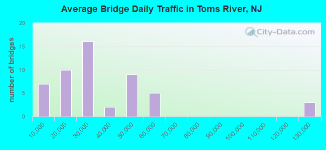
- 1,648,706Total average daily traffic
- 57,071Total average daily truck traffic
- National Bridge Inventory (NBI) Registered Bridges for Toms River
- No street view available for this location
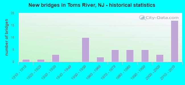
- New bridges - historical statistics
- 11910-1919
- 11920-1929
- 31930-1939
- 101950-1959
- 21960-1969
- 51970-1979
- 51980-1989
- 51990-1999
- 32000-2009
- 172010-2019
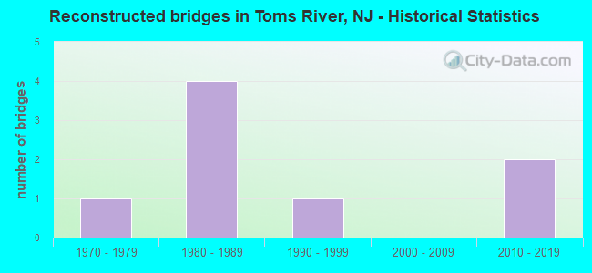
- Reconstructed bridges - Historical Statistics
- 11970-1979
- 41980-1989
- 11990-1999
- 02000-2009
- 22010-2019
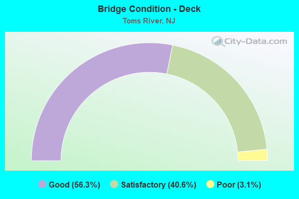
- Bridge Condition - Deck
- 56.3%Good
- 40.6%Satisfactory
- 3.1%Poor
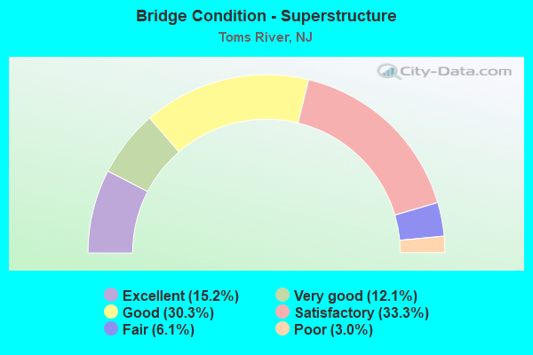
- Bridge Condition - Superstructure
- 15.2%Excellent
- 12.1%Very good
- 30.3%Good
- 33.3%Satisfactory
- 6.1%Fair
- 3.0%Poor
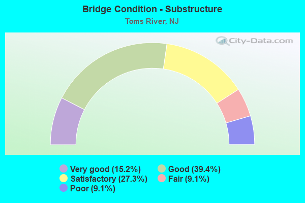
- Bridge Condition - Substructure
- 15.2%Very good
- 39.4%Good
- 27.3%Satisfactory
- 9.1%Fair
- 9.1%Poor
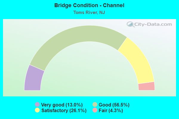
- Bridge Condition - Channel
- 13.0%Very good
- 56.5%Good
- 26.1%Satisfactory
- 4.3%Fair
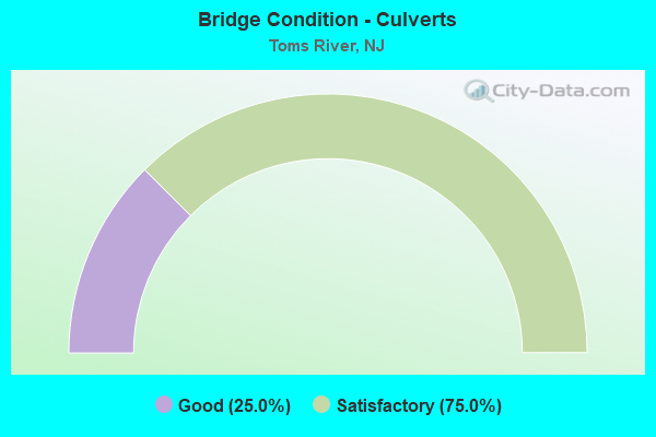
- Bridge Condition - Culverts
- 25.0%Good
- 75.0%Satisfactory
Find on map >> Show street view
Structure Number: 360823S, Location: JCT. RT 37 & GSP SB (Lat: 39.963819, Lng: -74.206844), Route carried "under" structure: State highway 37, Year Built: 1951, Structure Length: 0. m, Average Daily Traffic: 53,981 (year 2021), Truck Traffic: 4%, Features Intersected: NJ ROUTE 37, Facility Carried by Structure: GSP SB
Minimum Vertical Clearance: 4.80m (15.75ft), Kilometerpoint: 10.187, Lanes on structure: 4, Lanes under structure: 6, Material/Design: Steel, Design/Construction: Stringer/Multi-beam, Length of Maximum Span: 17.1m (56.1ft)
Find on map >> Show street view
Structure Number: 360841A, Location: 1.5 MI N OF RT37&GSP JCT (Lat: 39.987189, Lng: -74.210819), Route carried "under" structure: State highway 166, Year Built: 1998, Structure Length: 0. m, Average Daily Traffic: 20,425 (year 2021), Truck Traffic: 5%, Features Intersected: US 9/NJ 166, Facility Carried by Structure: EXIT RAMP D (RT 9)
Minimum Vertical Clearance: 5.18m (16.99ft), Kilometerpoint: 5.987, Lanes on structure: 2, Lanes under structure: 2, Material/Design: Steel continuous, Design/Construction: Stringer/Multi-beam, Length of Maximum Span: 45.1m (148.0ft)
Find on map >> Show street view
Structure Number: 360841A, Location: 1.5 MI N OF RT37&GSP JCT (Lat: 39.987189, Lng: -74.210819), Route carried "under" structure: US 9, Year Built: 1998, Structure Length: 0. m, Average Daily Traffic: 25,670 (year 2021), Truck Traffic: 4%, Features Intersected: US 9/NJ 166
Minimum Vertical Clearance: 5.73m (18.80ft), Kilometerpoint: 152.083, Lanes on structure: 2, Lanes under structure: 1, Material/Design: Steel continuous, Design/Construction: Stringer/Multi-beam, Length of Maximum Span: 45.1m (148.0ft)
Find on map >> Show street view
Structure Number: 360841S, Location: 1.8 MI N OF RT37&GSP JCT (Lat: 39.988267, Lng: -74.210939), Route carried "under" structure: US 9, Year Built: 2014, Structure Length: 0. m, Average Daily Traffic: 25,670 (year 2021), Truck Traffic: 4%, Features Intersected: US 9/NJ 166, Facility Carried by Structure: GSP SB
Minimum Vertical Clearance: 5.72m (18.77ft), Kilometerpoint: 152.501, Lanes on structure: 3, Lanes under structure: 2, Material/Design: Steel continuous, Design/Construction: Stringer/Multi-beam, Length of Maximum Span: 41.1m (134.8ft)
Find on map >> Show street view
Structure Number: 360841S, Location: 1.8 MI N OF RT37&GSP JCT (Lat: 39.988267, Lng: -74.210939), Route carried "under" structure: State highway 166, Year Built: 2014, Structure Length: 0. m, Average Daily Traffic: 20,425 (year 2021), Truck Traffic: 5%, Features Intersected: US 9/NJ 166, Facility Carried by Structure: GSP SB
Minimum Vertical Clearance: 5.23m (17.16ft), Kilometerpoint: 5.987, Lanes on structure: 3, Lanes under structure: 1, Material/Design: Steel continuous, Design/Construction: Stringer/Multi-beam, Length of Maximum Span: 41.1m (134.8ft)
Find on map >> Show street view
Structure Number: 360844S, Location: 2.1 MI N OF GSP & Rt 37 (Lat: 39.992289, Lng: -74.209008), Route carried "under" structure: County highway 571, Year Built: 2014, Structure Length: 0. m, Average Daily Traffic: 21,455 (year 2021), Truck Traffic: 4%, Features Intersected: INDIAN HEAD RD (CR571), Facility Carried by Structure: GSP SB
Minimum Vertical Clearance: 4.98m (16.34ft), Kilometerpoint: 9.720, Lanes on structure: 3, Lanes under structure: 4, Material/Design: Steel, Design/Construction: Stringer/Multi-beam, Length of Maximum Span: 28.0m (91.9ft)
Find on map >> Show street view
Structure Number: 360852N, Location: 1 MI NE OF RT9 & GSP JCT (Lat: 40.002797, Lng: -74.201364), Route carried "under" structure: County highway 623, Year Built: 2014, Structure Length: 0. m, Average Daily Traffic: 12,385 (year 2021), Truck Traffic: 4%, Features Intersected: OLD FREEHOLD RD (CR 623), Facility Carried by Structure: GSP NB
Minimum Vertical Clearance: 4.52m (14.83ft), Kilometerpoint: 4.184, Lanes on structure: 3, Lanes under structure: 2, Material/Design: Steel, Design/Construction: Stringer/Multi-beam, Length of Maximum Span: 28.0m (91.9ft)
Find on map >> Show street view
Structure Number: 360864N, Location: 2.9 Mi. S. of Route 70 (Lat: 40.015200, Lng: -74.185956), Route carried "under" structure: County highway 620, Year Built: 2013, Structure Length: 0. m, Average Daily Traffic: 8,413 (year 2021), Truck Traffic: 3%, Features Intersected: Church Road (CR 620), Facility Carried by Structure: GSP NB
Minimum Vertical Clearance: 4.50m (14.76ft), Kilometerpoint: 2.832, Lanes on structure: 3, Lanes under structure: 3, Material/Design: Steel, Design/Construction: Stringer/Multi-beam, Length of Maximum Span: 29.3m (96.1ft)
Find on map >> Show street view
Structure Number: 370841N, Location: 1.8 MI N OF RT37&GSP JCT (Lat: 39.254544, Lng: -74.210875), Route carried "under" structure: US 9, Year Built: 2015, Structure Length: 0. m, Average Daily Traffic: 25,670 (year 2021), Truck Traffic: 4%, Features Intersected: US 9/NJ 166, Facility Carried by Structure: GSP NB
Minimum Vertical Clearance: 5.49m (18.01ft), Kilometerpoint: 152.485, Lanes on structure: 3, Lanes under structure: 2, Material/Design: Steel continuous, Design/Construction: Stringer/Multi-beam, Length of Maximum Span: 41.1m (134.8ft)
Find on map >> Show street view
Structure Number: 370841N, Location: 1.8 MI N OF RT37&GSP JCT (Lat: 39.254544, Lng: -74.210875), Route carried "under" structure: State highway 166, Year Built: 2015, Structure Length: 0. m, Average Daily Traffic: 20,425 (year 2021), Truck Traffic: 4%, Features Intersected: US 9/NJ 166, Facility Carried by Structure: GSP NB
Minimum Vertical Clearance: 5.28m (17.32ft), Kilometerpoint: 5.955, Lanes on structure: 3, Lanes under structure: 1, Material/Design: Steel continuous, Design/Construction: Stringer/Multi-beam, Length of Maximum Span: 41.1m (134.8ft)
Find on map >> Show street view
Structure Number: 370844N, Location: 2.1 mi. N of GSP & Rt. 37 (Lat: 39.992394, Lng: -74.208819), Route carried "under" structure: County highway 571, Year Built: 2014, Structure Length: 0. m, Average Daily Traffic: 21,455 (year 2021), Truck Traffic: 4%, Features Intersected: Indian Head Rd (CR 571), Facility Carried by Structure: GSP Northbound
Minimum Vertical Clearance: 4.55m (14.93ft), Kilometerpoint: 9.720, Lanes on structure: 4, Lanes under structure: 4, Material/Design: Steel, Design/Construction: Stringer/Multi-beam, Length of Maximum Span: 27.7m (90.9ft)
Find on map >> Show street view
Structure Number: 370853S, Location: 1.0 MI NE OF GSP & RT. 9 (Lat: 40.003431, Lng: -74.201461), Route carried "under" structure: County highway 623, Year Built: 2013, Structure Length: 0. m, Average Daily Traffic: 12,385 (year 2021), Truck Traffic: 4%, Features Intersected: Old Freehold Rd (CR 623), Facility Carried by Structure: GSP Southbound
Minimum Vertical Clearance: 4.67m (15.32ft), Kilometerpoint: 4.216, Lanes on structure: 3, Lanes under structure: 2, Material/Design: Steel, Design/Construction: Stringer/Multi-beam, Length of Maximum Span: 27.7m (90.9ft)