Bridge Statistics for Troy, Illinois (IL)
Condition, Traffic, Stress, Structural Evaluation, Project Costs
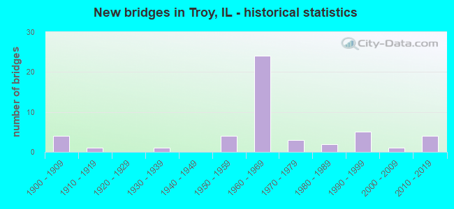
- New bridges - historical statistics
- 41900-1909
- 11910-1919
- 11930-1939
- 41950-1959
- 241960-1969
- 31970-1979
- 21980-1989
- 51990-1999
- 12000-2009
- 42010-2019
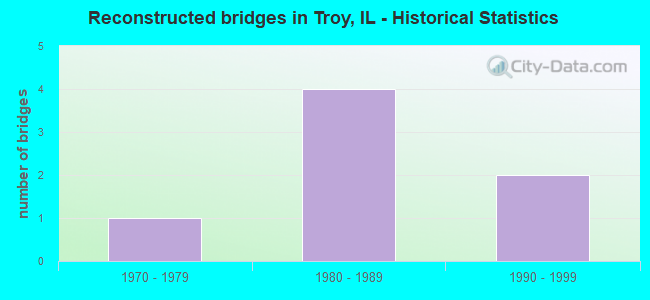
- Reconstructed bridges - Historical Statistics
- 11970-1979
- 41980-1989
- 21990-1999
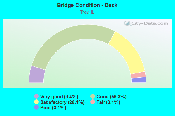
- Bridge Condition - Deck
- 9.4%Very good
- 56.3%Good
- 28.1%Satisfactory
- 3.1%Fair
- 3.1%Poor
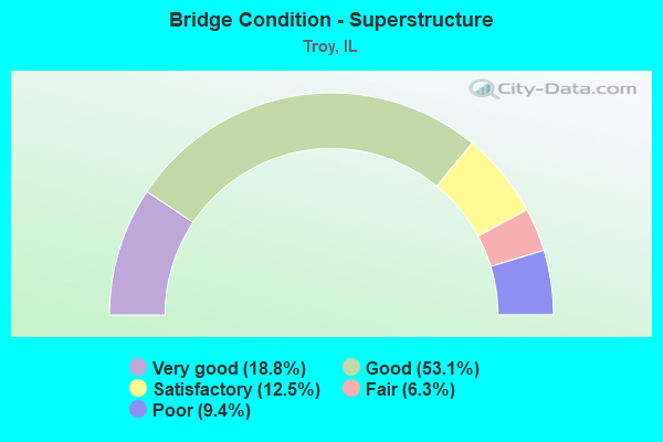
- Bridge Condition - Superstructure
- 18.8%Very good
- 53.1%Good
- 12.5%Satisfactory
- 6.3%Fair
- 9.4%Poor
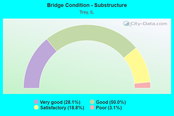
- Bridge Condition - Substructure
- 28.1%Very good
- 50.0%Good
- 18.8%Satisfactory
- 3.1%Poor
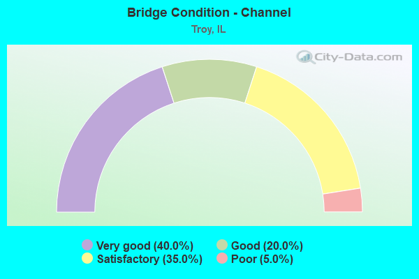
- Bridge Condition - Channel
- 40.0%Very good
- 20.0%Good
- 35.0%Satisfactory
- 5.0%Poor
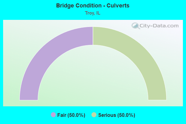
- Bridge Condition - Culverts
- 50.0%Fair
- 50.0%Serious
Find on map >> Show street view
Structure Number: 600338, Location: W. OF TROY (Lat: 38.732281, Lng: -89.912489), Route carried "under" structure: Interstate 55, Year Built: 2012, Structure Length: 0. m, Average Daily Traffic: 43,000 (year 2021), Truck Traffic: 28%, Features Intersected: FAI 55/70, Facility Carried by Structure: IL 162
Minimum Vertical Clearance: 5.38m (17.65ft), Kilometerpoint: 28.855, Lanes on structure: 8, Lanes under structure: 4, Material/Design: Steel continuous, Design/Construction: Stringer/Multi-beam, Length of Maximum Span: 24.4m (80.1ft)
Find on map >> Show street view
Structure Number: 609921, Location: 3.25 MI E COLLINSVIL (Lat: 38.677125, Lng: -89.909178), Route carried "under" structure: County highway , Year Built: 1900, Structure Length: 0. m, Average Daily Traffic: 100 (year 2021), Truck Traffic: 12%, Features Intersected: TR 202, Facility Carried by Structure: CONRAIL
Minimum Vertical Clearance: 4.09m (13.42ft), Kilometerpoint: 0.177, Lanes under structure: 1, Material/Design: Concrete, Design/Construction: Slab, Length of Maximum Span: 6.1m (20.0ft)
Find on map >> Show street view
Structure Number: 609922, Location: 2.0 MI S TROY (Lat: 38.706869, Lng: -89.847081), Route carried "under" structure: County highway , Year Built: 1900, Structure Length: 0. m, Average Daily Traffic: 300 (year 2021), Truck Traffic: 16%, Features Intersected: TR 230, Facility Carried by Structure: CONRAIL
Minimum Vertical Clearance: 4.27m (14.01ft), Kilometerpoint: 1.432, Lanes under structure: 1, Material/Design: Concrete, Design/Construction: Slab, Length of Maximum Span: 6.1m (20.0ft)
Find on map >> Show street view
Structure Number: 609924, Location: 3.5 MI E COLLINSVILL (Lat: 38.679811, Lng: -89.902800), Route carried "under" structure: County highway , Year Built: 1900, Structure Length: 0. m, Average Daily Traffic: 150 (year 2021), Truck Traffic: 17%, Features Intersected: TR 363, Facility Carried by Structure: CONRAIL
Minimum Vertical Clearance: 3.78m (12.40ft), Kilometerpoint: 2.044, Lanes under structure: 2, Material/Design: Concrete, Design/Construction: Box Beam or Girders - Single/Spread, Length of Maximum Span: 6.1m (20.0ft)