Bridge Statistics for Tunica Resorts, Mississippi (MS)
Condition, Traffic, Stress, Structural Evaluation, Project Costs
- National Bridge Inventory (NBI) Statistics
- 48Number of bridges
- 705ft / 215mTotal length
- $2,304,450,000Total costs
- 113,236Total average daily traffic
- 12,686Total average daily truck traffic
- National Bridge Inventory (NBI) Registered Bridges for Tunica Resorts
- No street view available for this location
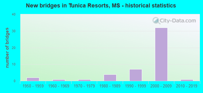
- New bridges - historical statistics
- 21950-1959
- 11960-1969
- 11970-1979
- 41980-1989
- 71990-1999
- 322000-2009
- 12010-2019


- Bridge Condition - Deck
- 36.7%Very good
- 50.0%Good
- 13.3%Satisfactory

- Bridge Condition - Superstructure
- 43.3%Very good
- 50.0%Good
- 6.7%Satisfactory

- Bridge Condition - Substructure
- 16.7%Very good
- 73.3%Good
- 10.0%Satisfactory

- Bridge Condition - Channel
- 3.1%Excellent
- 28.1%Very good
- 53.1%Good
- 12.5%Satisfactory
- 3.1%Fair

- Bridge Condition - Culverts
- 80.0%Very good
- 20.0%Good
Find on map >> Show street view
Structure Number: 2100061017311, Location: 0.1 MI N TUNICA CL (Lat: 34.861019, Lng: -90.246253), Route carried "on" structure: US 61, Year Built: 1985, Status: Open, Structure Length: 0.64m (2.10ft), Average Daily Traffic: 6,500 (year 2020), Truck Traffic: 18%, Average Future Daily Traffic: 6,900 (year 2040), Design Load: HS 20, Features Intersected: CANAL
Minimum Vertical Clearance: 30+ m (98+ ft), Kilometerpoint: 0.031, Lanes on structure: 5, Base Highway Network: Yes (Inventory Route: 6, Subroute: 1), Owner: State Highway Agency, Approaching Roadway Width: 12.8m (42.0ft), Skew: 24 degrees, Material/Design: Concrete, Design/Construction: Culvert, Number Of Spans In Main Unit: 1, Length of Maximum Span: 4.3m (14.1ft)
Condition: Channel: Good, Culverts: Good, Operating Rating: 79.2 metric tons, Method Used To Determine Operating Rating: Load Factor (LF), Inventory Rating: 47.7 metric tons, Method Used To Determine Inventory Rating: Load Factor (LF), Structural Evaluation: Better than present minimum criteria, Waterway Adequacy: Equal to present desirable criteria, Approach Roadway Alignment: Equal to present desirable criteria, Designated Inspection Frequency: Every 24 months, Inspection Date: June 2020
Find on map >> Show street view
Structure Number: 21000610173124, Location: 1.5 MI N TUNICA CL (Lat: 34.875053, Lng: -90.228847), Route carried "on" structure: US 61, Year Built: 1986, Status: Open, Structure Length: 1.49m (4.89ft), Average Daily Traffic: 6,500 (year 2020), Truck Traffic: 18%, Average Future Daily Traffic: 6,900 (year 2040), Design Load: HS 20, Features Intersected: CANAL
Minimum Vertical Clearance: 30+ m (98+ ft), Kilometerpoint: 2.256, Lanes on structure: 4, Base Highway Network: Yes (Inventory Route: 6, Subroute: 1), Owner: State Highway Agency, Approaching Roadway Width: 25.6m (84.0ft), Skew: 24 degrees, Material/Design: Concrete, Design/Construction: Culvert, Number Of Spans In Main Unit: 2, Length of Maximum Span: 4.9m (16.1ft)
Condition: Channel: Very good, Culverts: Good, Operating Rating: 62.1 metric tons, Method Used To Determine Operating Rating: Load Factor (LF), Inventory Rating: 36.9 metric tons, Method Used To Determine Inventory Rating: Load Factor (LF), Structural Evaluation: Better than present minimum criteria, Waterway Adequacy: Equal to present desirable criteria, Approach Roadway Alignment: Equal to present desirable criteria, Length Of Structure Improvement: 1.49m (4.89ft), Designated Inspection Frequency: Every 24 months, Inspection Date: June 2020, Bridge Improvement Cost: $187,000,000, Roadway Improvement Cost: $200,000,000, Total Project Cost: $449,000,000
Find on map >> Show street view
Structure Number: 21000610173133B, Location: 2.4 MI N TUNICA CL (Lat: 34.883817, Lng: -90.217986), Route carried "on" structure: US 61, Year Built: 1986, Status: Open, Structure Length: 10.76m (35.30ft), Average Daily Traffic: 3,950 (year 2020), Truck Traffic: 16%, Average Future Daily Traffic: 4,200 (year 2040), Design Load: HS 20, Features Intersected: CNIC RR
Minimum Vertical Clearance: 30+ m (98+ ft), Kilometerpoint: 3.647, Lanes on structure: 2, Base Highway Network: Yes (Inventory Route: 6, Subroute: 1), Owner: State Highway Agency, Approaching Roadway Width: 12.8m (42.0ft), Skew: 4 degrees, Material/Design: Prestressed concrete continuous, Design/Construction: Stringer/Multi-beam, Number Of Spans In Main Unit: 1, Number Of Approach Spans: 4, Length of Maximum Span: 24.4m (80.1ft), Curb-To-Curb Width: 12.8m (42.0ft), Out-to-Out Width: 13.7m (44.9ft)
Condition: Deck: Satisfactory, Superstructure: Good, Substructure: Good, Operating Rating: 55.8 metric tons, Method Used To Determine Operating Rating: Load Factor (LF), Inventory Rating: 23.5 metric tons, Method Used To Determine Inventory Rating: Load Factor (LF), Structural Evaluation: Equal to present minimum criteria, Deck Geometry: Equal to present desirable criteria, Underclear: Superior to present desirable criteria, Approach Roadway Alignment: Equal to present desirable criteria, Designated Inspection Frequency: Every 24 months, Inspection Date: June 2020, Deck Structure Type: Concrete Cast-file-Place
Find on map >> Show street view
Structure Number: 31000030721957, Location: 11.0 MI N SR 4 (Lat: 34.788631, Lng: -90.244158), Route carried "on" structure: State highway 3, Year Built: 1959, Status: Open, Structure Length: 2.74m (8.99ft), Average Daily Traffic: 1,200 (year 2020), Truck Traffic: 14%, Average Future Daily Traffic: 1,200 (year 2040), Design Load: HS 15, Features Intersected: LOST LAKE BAYOU
Minimum Vertical Clearance: 30+ m (98+ ft), Kilometerpoint: 18.622, Lanes on structure: 2, Base Highway Network: Yes (, Subroute: 2), Owner: State Highway Agency, Approaching Roadway Width: 7.9m (25.9ft), Skew: 3 degrees, Material/Design: Concrete, Design/Construction: Slab, Number Of Spans In Main Unit: 3, Length of Maximum Span: 9.1m (29.9ft), Curb or Sidewalk Widths: Left: 0.5m (1.6ft), Right: 0.5m (1.6ft), Curb-To-Curb Width: 7.9m (25.9ft), Out-to-Out Width: 8.9m (29.2ft)
Condition: Deck: Good, Superstructure: Good, Substructure: Good, Channel: Good, Operating Rating: 41.3 metric tons, Method Used To Determine Operating Rating: Load Factor (LF), Inventory Rating: 24.8 metric tons, Method Used To Determine Inventory Rating: Load Factor (LF), Structural Evaluation: Equal to present minimum criteria, Deck Geometry: Meets minimum limits, Waterway Adequacy: Equal to present minimum criteria, Approach Roadway Alignment: Equal to present desirable criteria, Length Of Structure Improvement: 4.05m (13.29ft), Designated Inspection Frequency: Every 24 months, Inspection Date: September 2021, Bridge Improvement Cost: $315,000,000, Roadway Improvement Cost: $32,000,000, Total Project Cost: $939,000,000, Deck Structure Type: Concrete Cast-file-Place
Find on map >> Show street view
Structure Number: 31000030721975, Location: 12.7 MI N SR 4 (Lat: 34.813406, Lng: -90.236517), Route carried "on" structure: State highway 3, Year Built: 1959, Status: Open, Structure Length: 3.05m (10.01ft), Average Daily Traffic: 1,200 (year 2020), Truck Traffic: 14%, Average Future Daily Traffic: 1,200 (year 2040), Design Load: HS 15, Features Intersected: BEAVER DAM BAYOU
Minimum Vertical Clearance: 30+ m (98+ ft), Kilometerpoint: 21.457, Lanes on structure: 2, Base Highway Network: Yes (, Subroute: 2), Owner: State Highway Agency, Approaching Roadway Width: 7.9m (25.9ft), Material/Design: Concrete, Design/Construction: Slab, Number Of Spans In Main Unit: 1, Number Of Approach Spans: 2, Length of Maximum Span: 12.2m (40.0ft), Curb or Sidewalk Widths: Left: 0.5m (1.6ft), Right: 0.5m (1.6ft), Curb-To-Curb Width: 7.9m (25.9ft), Out-to-Out Width: 8.9m (29.2ft)
Condition: Deck: Good, Superstructure: Good, Substructure: Good, Channel: Good, Operating Rating: 41.3 metric tons, Method Used To Determine Operating Rating: Load Factor (LF), Inventory Rating: 24.8 metric tons, Method Used To Determine Inventory Rating: Load Factor (LF), Structural Evaluation: Equal to present minimum criteria, Deck Geometry: Meets minimum limits, Waterway Adequacy: Equal to present minimum criteria, Approach Roadway Alignment: Equal to present desirable criteria, Length Of Structure Improvement: 3.96m (12.99ft), Designated Inspection Frequency: Every 24 months, Inspection Date: September 2021, Bridge Improvement Cost: $307,000,000, Roadway Improvement Cost: $31,000,000, Total Project Cost: $915,000,000, Deck Structure Type: Concrete Cast-file-Place
Find on map >> Show street view
Structure Number: 31003040170000A, Location: SR 304 OVER US 61 (Lat: 34.868347, Lng: -90.236503), Route carried "on" structure: State highway 304, Year Built: 2006, Status: Open, Structure Length: 15.30m (50.20ft), Average Daily Traffic: 2,300 (year 2020), Truck Traffic: 7%, Average Future Daily Traffic: 2,450 (year 2040), Design Load: HS 20, Features Intersected: US 61
Minimum Vertical Clearance: 30+ m (98+ ft), Kilometerpoint: 4.934, Lanes on structure: 1, Lanes under structure: 5, Base Highway Network: Yes (Inventory Route: 30, Subroute: 1), Owner: State Highway Agency, Approaching Roadway Width: 12.6m (41.3ft), Skew: 4 degrees, Material/Design: Prestressed concrete continuous, Design/Construction: Stringer/Multi-beam, Number Of Spans In Main Unit: 4, Length of Maximum Span: 38.0m (124.7ft), Curb-To-Curb Width: 12.6m (41.3ft), Out-to-Out Width: 13.5m (44.3ft)
Condition: Deck: Very good, Superstructure: Good, Substructure: Good, Operating Rating: 70.7 metric tons, Method Used To Determine Operating Rating: Load Factor (LF), Inventory Rating: 30.8 metric tons, Method Used To Determine Inventory Rating: Load Factor (LF), Structural Evaluation: Better than present minimum criteria, Deck Geometry: Equal to present minimum criteria, Underclear: Equal to present minimum criteria, Approach Roadway Alignment: Equal to present desirable criteria, Designated Inspection Frequency: Every 24 months, Inspection Date: November 2020, Deck Structure Type: Concrete Cast-file-Place
Find on map >> Show street view
Structure Number: 31003040170000B, Location: SR 304 OVER US 61 (Lat: 34.868094, Lng: -90.238514), Route carried "on" structure: State highway 304, Year Built: 2006, Status: Open, Structure Length: 15.30m (50.20ft), Average Daily Traffic: 2,300 (year 2020), Truck Traffic: 7%, Average Future Daily Traffic: 2,450 (year 2040), Design Load: HS 20, Features Intersected: US 61
Minimum Vertical Clearance: 30+ m (98+ ft), Kilometerpoint: 0.000, Lanes on structure: 1, Lanes under structure: 5, Base Highway Network: Yes (Inventory Route: 30, Subroute: 1), Owner: State Highway Agency, Approaching Roadway Width: 12.6m (41.3ft), Skew: 4 degrees, Material/Design: Prestressed concrete continuous, Design/Construction: Stringer/Multi-beam, Number Of Spans In Main Unit: 4, Length of Maximum Span: 38.0m (124.7ft), Curb-To-Curb Width: 12.6m (41.3ft), Out-to-Out Width: 13.5m (44.3ft)
Condition: Deck: Good, Superstructure: Good, Substructure: Good, Operating Rating: 70.7 metric tons, Method Used To Determine Operating Rating: Load Factor (LF), Inventory Rating: 30.8 metric tons, Method Used To Determine Inventory Rating: Load Factor (LF), Structural Evaluation: Better than present minimum criteria, Deck Geometry: Equal to present minimum criteria, Underclear: Superior to present desirable criteria, Approach Roadway Alignment: Equal to present desirable criteria, Designated Inspection Frequency: Every 24 months, Inspection Date: October 2020, Deck Structure Type: Concrete Cast-file-Place
Find on map >> Show street view
Structure Number: 31003040170003, Location: 0.3 MI E US 61 (Lat: 34.868094, Lng: -90.233164), Route carried "on" structure: State highway 304, Year Built: 2006, Status: Open, Structure Length: 0.71m (2.33ft), Average Daily Traffic: 4,600 (year 2020), Truck Traffic: 7%, Average Future Daily Traffic: 4,900 (year 2040), Design Load: HS 20, Features Intersected: CREEK
Minimum Vertical Clearance: 30+ m (98+ ft), Kilometerpoint: 0.489, Lanes on structure: 4, Base Highway Network: Yes (Inventory Route: 30, Subroute: 1), Owner: State Highway Agency, Approaching Roadway Width: 25.0m (82.0ft), Skew: 1 degrees, Material/Design: Concrete, Design/Construction: Culvert, Number Of Spans In Main Unit: 2, Length of Maximum Span: 3.0m (9.8ft)
Condition: Channel: Very good, Culverts: Very good, Structural Evaluation: Equal to present desirable criteria, Waterway Adequacy: Equal to present desirable criteria, Approach Roadway Alignment: Superior to present desirable criteria, Designated Inspection Frequency: Every 24 months, Inspection Date: October 2020
Find on map >> Show street view
Structure Number: 31003040170005, Location: 0.2 MI W SR 3 (Lat: 34.868086, Lng: -90.229117), Route carried "on" structure: State highway 304, Year Built: 2006, Status: Open, Structure Length: 0.69m (2.26ft), Average Daily Traffic: 4,600 (year 2020), Truck Traffic: 7%, Average Future Daily Traffic: 4,900 (year 2040), Design Load: HS 20, Features Intersected: CREEK
Minimum Vertical Clearance: 30+ m (98+ ft), Kilometerpoint: 0.858, Lanes on structure: 4, Base Highway Network: Yes (Inventory Route: 30, Subroute: 1), Owner: State Highway Agency, Approaching Roadway Width: 25.0m (82.0ft), Skew: 1 degrees, Material/Design: Concrete, Design/Construction: Culvert, Number Of Spans In Main Unit: 2, Length of Maximum Span: 3.0m (9.8ft)
Condition: Channel: Very good, Culverts: Very good, Inventory Rating: 82.7 metric tons, Method Used To Determine Inventory Rating: Load Factor (LF), Structural Evaluation: Equal to present desirable criteria, Waterway Adequacy: Superior to present desirable criteria, Approach Roadway Alignment: Equal to present desirable criteria, Designated Inspection Frequency: Every 24 months, Inspection Date: October 2020
Find on map >> Show street view
Structure Number: 31003040170007A, Location: SR 304 OVER SR 3 (Lat: 34.868336, Lng: -90.225019), Route carried "on" structure: State highway 304, Year Built: 2006, Status: Open, Structure Length: 7.97m (26.15ft), Average Daily Traffic: 2,300 (year 2020), Truck Traffic: 7%, Average Future Daily Traffic: 2,450 (year 2040), Design Load: HS 20, Features Intersected: SR 3
Minimum Vertical Clearance: 30+ m (98+ ft), Kilometerpoint: 3.887, Lanes on structure: 2, Lanes under structure: 2, Base Highway Network: Yes (Inventory Route: 30, Subroute: 1), Owner: State Highway Agency, Approaching Roadway Width: 12.6m (41.3ft), Material/Design: Prestressed concrete continuous, Design/Construction: Stringer/Multi-beam, Number Of Spans In Main Unit: 3, Length of Maximum Span: 31.0m (101.7ft), Curb-To-Curb Width: 12.6m (41.3ft), Out-to-Out Width: 13.5m (44.3ft)
Condition: Deck: Very good, Superstructure: Very good, Substructure: Very good, Operating Rating: 65.3 metric tons, Method Used To Determine Operating Rating: Load Factor (LF), Inventory Rating: 36.1 metric tons, Method Used To Determine Inventory Rating: Load Factor (LF), Structural Evaluation: Equal to present desirable criteria, Deck Geometry: Better than present minimum criteria, Underclear: Superior to present desirable criteria, Approach Roadway Alignment: Equal to present desirable criteria, Designated Inspection Frequency: Every 24 months, Inspection Date: November 2020
Find on map >> Show street view
Structure Number: 31003040170007B, Location: SR 304 OVER SR 3 (Lat: 34.868081, Lng: -90.225961), Route carried "on" structure: State highway 304, Year Built: 2006, Status: Open, Structure Length: 7.97m (26.15ft), Average Daily Traffic: 2,300 (year 2020), Truck Traffic: 7%, Average Future Daily Traffic: 2,450 (year 2040), Design Load: HS 20, Features Intersected: SR 3
Minimum Vertical Clearance: 30+ m (98+ ft), Kilometerpoint: 1.146, Lanes on structure: 2, Lanes under structure: 2, Base Highway Network: Yes (Inventory Route: 30, Subroute: 1), Owner: State Highway Agency, Approaching Roadway Width: 12.6m (41.3ft), Material/Design: Prestressed concrete continuous, Design/Construction: Stringer/Multi-beam, Number Of Spans In Main Unit: 3, Length of Maximum Span: 31.0m (101.7ft), Curb-To-Curb Width: 12.6m (41.3ft), Out-to-Out Width: 13.5m (44.3ft)
Condition: Deck: Good, Superstructure: Very good, Substructure: Good, Operating Rating: 65.3 metric tons, Method Used To Determine Operating Rating: Load Factor (LF), Inventory Rating: 36.1 metric tons, Method Used To Determine Inventory Rating: Load Factor (LF), Structural Evaluation: Better than present minimum criteria, Deck Geometry: Better than present minimum criteria, Underclear: Superior to present desirable criteria, Approach Roadway Alignment: Equal to present desirable criteria, Designated Inspection Frequency: Every 24 months, Inspection Date: October 2020, Deck Structure Type: Concrete Cast-file-Place
Find on map >> Show street view
Structure Number: 31003040170011A, Location: 0.4 MI E SR 3 (Lat: 34.868325, Lng: -90.217433), Route carried "on" structure: State highway 304, Year Built: 2006, Status: Open, Structure Length: 9.07m (29.76ft), Average Daily Traffic: 2,300 (year 2020), Truck Traffic: 7%, Average Future Daily Traffic: 2,450 (year 2040), Design Load: HS 20, Features Intersected: CNIC RR
Minimum Vertical Clearance: 30+ m (98+ ft), Kilometerpoint: 3.195, Lanes on structure: 2, Base Highway Network: Yes (Inventory Route: 30, Subroute: 1), Owner: State Highway Agency, Approaching Roadway Width: 12.6m (41.3ft), Material/Design: Prestressed concrete continuous, Design/Construction: Stringer/Multi-beam, Number Of Spans In Main Unit: 3, Length of Maximum Span: 30.0m (98.4ft), Curb-To-Curb Width: 12.6m (41.3ft), Out-to-Out Width: 13.5m (44.3ft)
Condition: Deck: Very good, Superstructure: Very good, Substructure: Very good, Operating Rating: 70.9 metric tons, Method Used To Determine Operating Rating: Load Factor (LF), Inventory Rating: 34.6 metric tons, Method Used To Determine Inventory Rating: Load Factor (LF), Structural Evaluation: Equal to present desirable criteria, Deck Geometry: Better than present minimum criteria, Underclear: Superior to present desirable criteria, Approach Roadway Alignment: Equal to present desirable criteria, Designated Inspection Frequency: Every 24 months, Inspection Date: November 2020, Deck Structure Type: Concrete Cast-file-Place
Find on map >> Show street view
Structure Number: 31003040170011B, Location: 0.4 MI E SR 3 (Lat: 34.868069, Lng: -90.218406), Route carried "on" structure: State highway 304, Year Built: 2006, Status: Open, Structure Length: 9.07m (29.76ft), Average Daily Traffic: 2,300 (year 2020), Truck Traffic: 7%, Average Future Daily Traffic: 2,450 (year 2040), Design Load: HS 20, Features Intersected: CNIC RR
Minimum Vertical Clearance: 30+ m (98+ ft), Kilometerpoint: 1.835, Lanes on structure: 2, Base Highway Network: Yes (Inventory Route: 30, Subroute: 1), Owner: State Highway Agency, Approaching Roadway Width: 12.6m (41.3ft), Material/Design: Prestressed concrete continuous, Design/Construction: Stringer/Multi-beam, Number Of Spans In Main Unit: 3, Length of Maximum Span: 30.0m (98.4ft), Curb-To-Curb Width: 12.6m (41.3ft), Out-to-Out Width: 13.5m (44.3ft)
Condition: Deck: Good, Superstructure: Very good, Substructure: Good, Operating Rating: 70.9 metric tons, Method Used To Determine Operating Rating: Load Factor (LF), Inventory Rating: 34.6 metric tons, Method Used To Determine Inventory Rating: Load Factor (LF), Structural Evaluation: Better than present minimum criteria, Deck Geometry: Better than present minimum criteria, Underclear: Superior to present desirable criteria, Approach Roadway Alignment: Equal to present desirable criteria, Designated Inspection Frequency: Every 24 months, Inspection Date: October 2020, Deck Structure Type: Concrete Cast-file-Place
Find on map >> Show street view
Structure Number: 31003040170013A, Location: 0.6 MI E SR 3 (Lat: 34.868325, Lng: -90.214356), Route carried "on" structure: State highway 304, Year Built: 2006, Status: Open, Structure Length: 10.85m (35.60ft), Average Daily Traffic: 2,300 (year 2020), Truck Traffic: 7%, Average Future Daily Traffic: 2,450 (year 2040), Design Load: HS 20, Features Intersected: LAKESIDE RD & BAYOU
Minimum Vertical Clearance: 30+ m (98+ ft), Kilometerpoint: 2.915, Lanes on structure: 2, Lanes under structure: 2, Base Highway Network: Yes (Inventory Route: 30, Subroute: 1), Owner: State Highway Agency, Approaching Roadway Width: 12.6m (41.3ft), Skew: 1 degrees, Material/Design: Prestressed concrete, Design/Construction: Stringer/Multi-beam, Number Of Spans In Main Unit: 1, Number Of Approach Spans: 7, Length of Maximum Span: 18.0m (59.1ft), Curb-To-Curb Width: 12.6m (41.3ft), Out-to-Out Width: 13.5m (44.3ft)
Condition: Deck: Very good, Superstructure: Very good, Substructure: Good, Channel: Very good, Operating Rating: 57.7 metric tons, Method Used To Determine Operating Rating: Load Factor (LF), Inventory Rating: 34.6 metric tons, Method Used To Determine Inventory Rating: Load Factor (LF), Structural Evaluation: Better than present minimum criteria, Deck Geometry: Better than present minimum criteria, Underclear: Better than present minimum criteria, Waterway Adequacy: Superior to present desirable criteria, Approach Roadway Alignment: Equal to present desirable criteria, Designated Inspection Frequency: Every 24 months, Inspection Date: November 2020, Deck Structure Type: Concrete Cast-file-Place
Find on map >> Show street view
Structure Number: 31003040170013B, Location: 0.6 MI E SR 3 (Lat: 34.868069, Lng: -90.215411), Route carried "on" structure: State highway 304, Year Built: 2006, Status: Open, Structure Length: 10.85m (35.60ft), Average Daily Traffic: 2,300 (year 2020), Truck Traffic: 7%, Average Future Daily Traffic: 2,450 (year 2040), Design Load: HS 20, Features Intersected: LAKESIDE RD & BAYOU
Minimum Vertical Clearance: 30+ m (98+ ft), Kilometerpoint: 2.108, Lanes on structure: 2, Lanes under structure: 2, Base Highway Network: Yes (Inventory Route: 30, Subroute: 1), Owner: State Highway Agency, Approaching Roadway Width: 12.6m (41.3ft), Skew: 1 degrees, Material/Design: Prestressed concrete, Design/Construction: Stringer/Multi-beam, Number Of Spans In Main Unit: 1, Number Of Approach Spans: 7, Length of Maximum Span: 18.0m (59.1ft), Curb-To-Curb Width: 12.6m (41.3ft), Out-to-Out Width: 13.5m (44.3ft)
Condition: Deck: Very good, Superstructure: Very good, Substructure: Good, Channel: Good, Operating Rating: 57.7 metric tons, Method Used To Determine Operating Rating: Load Factor (LF), Inventory Rating: 34.6 metric tons, Method Used To Determine Inventory Rating: Load Factor (LF), Structural Evaluation: Better than present minimum criteria, Deck Geometry: Better than present minimum criteria, Underclear: Better than present minimum criteria, Waterway Adequacy: Superior to present desirable criteria, Approach Roadway Alignment: Equal to present desirable criteria, Designated Inspection Frequency: Every 24 months, Inspection Date: November 2020, Deck Structure Type: Concrete Cast-file-Place
Find on map >> Show street view
Structure Number: 31003040170023A, Location: 1.6 MI E SR 3 (Lat: 34.868994, Lng: -90.197400), Route carried "on" structure: State highway 304, Year Built: 2006, Status: Open, Structure Length: 4.85m (15.91ft), Average Daily Traffic: 2,300 (year 2020), Truck Traffic: 7%, Average Future Daily Traffic: 2,450 (year 2040), Design Load: HS 20, Features Intersected: DUCK POND BAYOU RELIEF
Minimum Vertical Clearance: 30+ m (98+ ft), Kilometerpoint: 1.362, Lanes on structure: 2, Base Highway Network: Yes (Inventory Route: 30, Subroute: 1), Owner: State Highway Agency, Approaching Roadway Width: 12.6m (41.3ft), Material/Design: Prestressed concrete continuous, Design/Construction: Stringer/Multi-beam, Number Of Spans In Main Unit: 4, Length of Maximum Span: 12.0m (39.4ft), Curb-To-Curb Width: 12.6m (41.3ft), Out-to-Out Width: 13.5m (44.3ft)
Condition: Deck: Very good, Superstructure: Good, Substructure: Good, Channel: Excellent, Operating Rating: 57.5 metric tons, Method Used To Determine Operating Rating: Load Factor (LF), Inventory Rating: 34.5 metric tons, Method Used To Determine Inventory Rating: Load Factor (LF), Structural Evaluation: Better than present minimum criteria, Deck Geometry: Better than present minimum criteria, Waterway Adequacy: Equal to present desirable criteria, Approach Roadway Alignment: Equal to present desirable criteria, Designated Inspection Frequency: Every 24 months, Inspection Date: November 2020, Deck Structure Type: Concrete Cast-file-Place
Find on map >> Show street view
Structure Number: 31003040170023B, Location: 1.6 MI E SR 3 (Lat: 34.868675, Lng: -90.197858), Route carried "on" structure: State highway 304, Year Built: 2006, Status: Open, Structure Length: 4.85m (15.91ft), Average Daily Traffic: 2,300 (year 2020), Truck Traffic: 7%, Average Future Daily Traffic: 2,450 (year 2040), Design Load: HS 20, Features Intersected: DUCK POND BAYOU RELIEF
Minimum Vertical Clearance: 30+ m (98+ ft), Kilometerpoint: 3.714, Lanes on structure: 2, Base Highway Network: Yes (Inventory Route: 30, Subroute: 1), Owner: State Highway Agency, Approaching Roadway Width: 12.6m (41.3ft), Material/Design: Prestressed concrete continuous, Design/Construction: Stringer/Multi-beam, Number Of Spans In Main Unit: 4, Length of Maximum Span: 12.0m (39.4ft), Curb-To-Curb Width: 12.6m (41.3ft), Out-to-Out Width: 13.5m (44.3ft)
Condition: Deck: Very good, Superstructure: Good, Substructure: Good, Channel: Very good, Operating Rating: 57.5 metric tons, Method Used To Determine Operating Rating: Load Factor (LF), Inventory Rating: 34.5 metric tons, Method Used To Determine Inventory Rating: Load Factor (LF), Structural Evaluation: Better than present minimum criteria, Deck Geometry: Better than present minimum criteria, Waterway Adequacy: Equal to present desirable criteria, Approach Roadway Alignment: Equal to present desirable criteria, Designated Inspection Frequency: Every 24 months, Inspection Date: November 2020, Deck Structure Type: Concrete Cast-file-Place
Find on map >> Show street view
Structure Number: 31007130720057A, Location: 0.7 MI E SR 3 (Lat: 34.830033, Lng: -90.219306), Route carried "on" structure: State highway 713, Year Built: 2006, Status: Open, Structure Length: 9.05m (29.69ft), Average Daily Traffic: 1,650 (year 2020), Truck Traffic: 9%, Average Future Daily Traffic: 1,750 (year 2040), Design Load: HS 20, Features Intersected: LAKE CORMORANT BAYOU
Minimum Vertical Clearance: 30+ m (98+ ft), Kilometerpoint: 2.736, Lanes on structure: 2, Base Highway Network: Yes (Inventory Route: 71, Subroute: 1), Owner: State Highway Agency, Approaching Roadway Width: 12.6m (41.3ft), Skew: 1 degrees, Material/Design: Prestressed concrete, Design/Construction: Stringer/Multi-beam, Number Of Spans In Main Unit: 1, Number Of Approach Spans: 6, Length of Maximum Span: 18.0m (59.1ft), Curb-To-Curb Width: 12.6m (41.3ft), Out-to-Out Width: 13.5m (44.3ft)
Condition: Deck: Very good, Superstructure: Very good, Substructure: Good, Channel: Good, Operating Rating: 57.7 metric tons, Method Used To Determine Operating Rating: Load Factor (LF), Inventory Rating: 34.6 metric tons, Method Used To Determine Inventory Rating: Load Factor (LF), Structural Evaluation: Better than present minimum criteria, Deck Geometry: Better than present minimum criteria, Waterway Adequacy: Superior to present desirable criteria, Approach Roadway Alignment: Equal to present desirable criteria, Designated Inspection Frequency: Every 24 months, Inspection Date: November 2020, Deck Structure Type: Concrete Cast-file-Place
Find on map >> Show street view
Structure Number: 31007130720057B, Location: 0.7 MI E SR 3 (Lat: 34.829472, Lng: -90.220197), Route carried "on" structure: State highway 713, Year Built: 2006, Status: Open, Structure Length: 9.05m (29.69ft), Average Daily Traffic: 1,650 (year 2020), Truck Traffic: 9%, Average Future Daily Traffic: 1,750 (year 2040), Design Load: HS 20, Features Intersected: LAKE CORMORANT BAYOU
Minimum Vertical Clearance: 30+ m (98+ ft), Kilometerpoint: 7.683, Lanes on structure: 2, Base Highway Network: Yes (Inventory Route: 71, Subroute: 1), Owner: State Highway Agency, Approaching Roadway Width: 12.6m (41.3ft), Skew: 1 degrees, Material/Design: Prestressed concrete, Design/Construction: Stringer/Multi-beam, Number Of Spans In Main Unit: 1, Number Of Approach Spans: 6, Length of Maximum Span: 18.0m (59.1ft), Curb-To-Curb Width: 12.6m (41.3ft), Out-to-Out Width: 13.5m (44.3ft)
Condition: Deck: Very good, Superstructure: Very good, Substructure: Good, Channel: Good, Operating Rating: 57.7 metric tons, Method Used To Determine Operating Rating: Load Factor (LF), Inventory Rating: 34.6 metric tons, Method Used To Determine Inventory Rating: Load Factor (LF), Structural Evaluation: Better than present minimum criteria, Deck Geometry: Better than present minimum criteria, Waterway Adequacy: Superior to present desirable criteria, Approach Roadway Alignment: Equal to present desirable criteria, Designated Inspection Frequency: Every 24 months, Inspection Date: October 2020, Deck Structure Type: Concrete Cast-file-Place
Find on map >> Show street view
Structure Number: 31007130720064A, Location: 1.5 MI E SR 3 (Lat: 34.838600, Lng: -90.210783), Route carried "on" structure: State highway 713, Year Built: 2006, Status: Open, Structure Length: 3.66m (12.01ft), Average Daily Traffic: 1,650 (year 2020), Truck Traffic: 9%, Average Future Daily Traffic: 1,750 (year 2040), Design Load: HS 20, Features Intersected: WHITES CREEK
Minimum Vertical Clearance: 30+ m (98+ ft), Kilometerpoint: 1.487, Lanes on structure: 2, Base Highway Network: Yes (Inventory Route: 71, Subroute: 1), Owner: State Highway Agency, Approaching Roadway Width: 12.6m (41.3ft), Skew: 3 degrees, Material/Design: Prestressed concrete continuous, Design/Construction: Stringer/Multi-beam, Number Of Spans In Main Unit: 3, Length of Maximum Span: 12.0m (39.4ft), Curb-To-Curb Width: 12.6m (41.3ft), Out-to-Out Width: 13.5m (44.3ft)
Condition: Deck: Very good, Superstructure: Good, Substructure: Good, Channel: Good, Operating Rating: 58.5 metric tons, Method Used To Determine Operating Rating: Load Factor (LF), Inventory Rating: 35.0 metric tons, Method Used To Determine Inventory Rating: Load Factor (LF), Structural Evaluation: Better than present minimum criteria, Deck Geometry: Better than present minimum criteria, Waterway Adequacy: Superior to present desirable criteria, Approach Roadway Alignment: Equal to present desirable criteria, Designated Inspection Frequency: Every 24 months, Inspection Date: November 2020, Deck Structure Type: Concrete Cast-file-Place
Find on map >> Show street view
Structure Number: 31007130720064B, Location: 1.5 MI E SR 3 (Lat: 34.838297, Lng: -90.210661), Route carried "on" structure: State highway 713, Year Built: 2006, Status: Open, Structure Length: 3.66m (12.01ft), Average Daily Traffic: 1,650 (year 2020), Truck Traffic: 9%, Average Future Daily Traffic: 1,750 (year 2040), Design Load: HS 20, Features Intersected: WHITES CREEK
Minimum Vertical Clearance: 30+ m (98+ ft), Kilometerpoint: 9.027, Lanes on structure: 2, Base Highway Network: Yes (Inventory Route: 71, Subroute: 1), Owner: State Highway Agency, Approaching Roadway Width: 12.6m (41.3ft), Skew: 3 degrees, Material/Design: Prestressed concrete continuous, Design/Construction: Stringer/Multi-beam, Number Of Spans In Main Unit: 3, Length of Maximum Span: 12.0m (39.4ft), Curb-To-Curb Width: 12.6m (41.3ft), Out-to-Out Width: 13.5m (44.3ft)
Condition: Deck: Very good, Superstructure: Very good, Substructure: Good, Channel: Good, Operating Rating: 58.5 metric tons, Method Used To Determine Operating Rating: Load Factor (LF), Inventory Rating: 35.0 metric tons, Method Used To Determine Inventory Rating: Load Factor (LF), Structural Evaluation: Better than present minimum criteria, Deck Geometry: Better than present minimum criteria, Waterway Adequacy: Superior to present desirable criteria, Approach Roadway Alignment: Equal to present desirable criteria, Designated Inspection Frequency: Every 24 months, Inspection Date: October 2020, Deck Structure Type: Concrete Cast-file-Place
Find on map >> Show street view
Structure Number: 41007130170079, Location: 0.7 MI S SR 304 (Lat: 34.860322, Lng: -90.197600), Route carried "on" structure: County highway 713, Year Built: 2006, Status: Open, Structure Length: 18.08m (59.32ft), Average Daily Traffic: 1,100 (year 2020), Truck Traffic: 10%, Average Future Daily Traffic: 1,100 (year 2040), Design Load: HS 20, Features Intersected: SR 713, Facility Carried by Structure: GREEN RIVER ROAD
Minimum Vertical Clearance: 30+ m (98+ ft), Kilometerpoint: 0.406, Lanes on structure: 2, Lanes under structure: 4, Owner: State Highway Agency, Approaching Roadway Width: 12.0m (39.4ft), Skew: 2 degrees, Material/Design: Prestressed concrete continuous, Design/Construction: Stringer/Multi-beam, Number Of Spans In Main Unit: 6, Length of Maximum Span: 30.0m (98.4ft), Curb-To-Curb Width: 12.0m (39.4ft), Out-to-Out Width: 12.9m (42.3ft)
Condition: Deck: Good, Superstructure: Good, Substructure: Good, Operating Rating: 68.8 metric tons, Method Used To Determine Operating Rating: Load Factor (LF), Inventory Rating: 33.2 metric tons, Method Used To Determine Inventory Rating: Load Factor (LF), Structural Evaluation: Better than present minimum criteria, Deck Geometry: Equal to present minimum criteria, Underclear: Superior to present desirable criteria, Approach Roadway Alignment: Equal to present desirable criteria, Designated Inspection Frequency: Every 24 months, Inspection Date: October 2020, Deck Structure Type: Concrete Cast-file-Place
Find on map >> Show street view
Structure Number: SA1700000000052, Location: SEC 35 T 2S R10W (Lat: 34.860617, Lng: -90.236450), Route carried "on" structure: County highway 17, Year Built: 1996, Status: Open, Structure Length: 0.68m (2.23ft), Average Daily Traffic: 800 (year 2018), Truck Traffic: 8%, Average Future Daily Traffic: 1,200 (year 2038), Design Load: HS 20, Features Intersected: DITCH NO 16, Facility Carried by Structure: GREEN RIVER ROAD
Minimum Vertical Clearance: 30+ m (98+ ft), Kilometerpoint: 0.965, Lanes on structure: 2, Owner: County Highway Agency, Approaching Roadway Width: 9.1m (29.9ft), Material/Design: Concrete, Design/Construction: Culvert, Number Of Spans In Main Unit: 2, Length of Maximum Span: 3.0m (9.8ft)
Condition: Channel: Satisfactory, Culverts: Very good, Operating Rating: 80.4 metric tons, Method Used To Determine Operating Rating: Load Factor (LF), Inventory Rating: 48.0 metric tons, Method Used To Determine Inventory Rating: Load Factor (LF), Structural Evaluation: Equal to present desirable criteria, Waterway Adequacy: Equal to present minimum criteria, Approach Roadway Alignment: Equal to present desirable criteria, Designated Inspection Frequency: Every 24 months, Inspection Date: May 2020
Find on map >> Show street view
Structure Number: SA1700000000053, Location: SEC 36 T 2S R10W B (Lat: 34.860467, Lng: -90.214972), Route carried "on" structure: County highway 17, Year Built: 1983, Status: Open, Structure Length: 6.10m (20.01ft), Average Daily Traffic: 600 (year 2018), Truck Traffic: 8%, Average Future Daily Traffic: 900 (year 2038), Design Load: HS 20, Features Intersected: LAKE CORMORANT BAYOU, Facility Carried by Structure: GREEN RIVER ROAD
Minimum Vertical Clearance: 30+ m (98+ ft), Kilometerpoint: 3.057, Lanes on structure: 2, Owner: County Highway Agency, Approaching Roadway Width: 6.7m (22.0ft), Material/Design: Prestressed concrete, Design/Construction: Stringer/Multi-beam, Number Of Spans In Main Unit: 5, Length of Maximum Span: 12.2m (40.0ft), Curb or Sidewalk Widths: Left: 0.5m (1.6ft), Right: 0.5m (1.6ft), Curb-To-Curb Width: 8.5m (27.9ft), Out-to-Out Width: 9.5m (31.2ft)
Condition: Deck: Satisfactory, Superstructure: Good, Substructure: Good, Channel: Good, Operating Rating: 61.8 metric tons, Method Used To Determine Operating Rating: Load Factor (LF), Inventory Rating: 37.6 metric tons, Method Used To Determine Inventory Rating: Load Factor (LF), Structural Evaluation: Better than present minimum criteria, Deck Geometry: Somewhat better than minimum adequacy, Waterway Adequacy: Equal to present desirable criteria, Approach Roadway Alignment: Equal to present desirable criteria, Designated Inspection Frequency: Every 24 months, Inspection Date: May 2020, Deck Structure Type: Concrete Cast-file-Place, Wearing Surface/Protective System: Wearing Surface: Monolithic Concrete
Find on map >> Show street view
Structure Number: SA1700000000082, Location: SEC 7 T 3S R 9W (Lat: 34.842383, Lng: -90.185833), Route carried "on" structure: County highway 768, Year Built: 1968, Status: Open, Structure Length: 0.84m (2.76ft), Average Daily Traffic: 400 (year 2020), Truck Traffic: 8%, Average Future Daily Traffic: 600 (year 2040), Design Load: HS 20, Features Intersected: WHITES CREEK, Facility Carried by Structure: WETONGA ROAD
Minimum Vertical Clearance: 30+ m (98+ ft), Kilometerpoint: 2.092, Lanes on structure: 2, Owner: County Highway Agency, Approaching Roadway Width: 6.4m (21.0ft), Material/Design: Prestressed concrete, Design/Construction: Slab, Number Of Spans In Main Unit: 1, Length of Maximum Span: 8.4m (27.6ft), Curb-To-Curb Width: 6.8m (22.3ft), Out-to-Out Width: 8.3m (27.2ft)
Condition: Deck: Good, Superstructure: Good, Substructure: Good, Channel: Good, Operating Rating: 43.2 metric tons, Method Used To Determine Operating Rating: Allowable Stress (AS), Inventory Rating: 32.4 metric tons, Method Used To Determine Inventory Rating: Allowable Stress (AS), Structural Evaluation: Better than present minimum criteria, Deck Geometry: Meets minimum limits, Waterway Adequacy: Better than present minimum criteria, Approach Roadway Alignment: Equal to present desirable criteria, Designated Inspection Frequency: Every 24 months, Inspection Date: May 2020, Deck Structure Type: Concrete Precast Panels, Wearing Surface/Protective System: Wearing Surface: Bituminous
Find on map >> Show street view
Structure Number: SA7200000000003, Location: SEC 26 T 3S R10W B (Lat: 34.801133, Lng: -90.219683), Route carried "on" structure: County highway 39, Year Built: 2006, Status: Open, Structure Length: 5.88m (19.29ft), Average Daily Traffic: 190 (year 2021), Truck Traffic: 10%, Average Future Daily Traffic: 300 (year 2041), Design Load: HS 20, Features Intersected: BIG SIX DITCH, Facility Carried by Structure: COUNTS ROAD
Minimum Vertical Clearance: 30+ m (98+ ft), Kilometerpoint: 4.828, Lanes on structure: 2, Owner: County Highway Agency, Approaching Roadway Width: 9.1m (29.9ft), Material/Design: Prestressed concrete, Design/Construction: Stringer/Multi-beam, Number Of Spans In Main Unit: 5, Length of Maximum Span: 18.0m (59.1ft), Curb or Sidewalk Widths: Left: 0.4m (1.3ft), Right: 0.4m (1.3ft), Curb-To-Curb Width: 9.1m (29.9ft), Out-to-Out Width: 9.9m (32.5ft)
Condition: Deck: Good, Superstructure: Very good, Substructure: Very good, Channel: Good, Operating Rating: 57.2 metric tons, Method Used To Determine Operating Rating: Load Factor (LF), Inventory Rating: 32.4 metric tons, Method Used To Determine Inventory Rating: Load Factor (LF), Structural Evaluation: Equal to present desirable criteria, Deck Geometry: Equal to present minimum criteria, Waterway Adequacy: Superior to present desirable criteria, Approach Roadway Alignment: Better than present minimum criteria, Designated Inspection Frequency: Every 24 months, Inspection Date: January 2021, Deck Structure Type: Concrete Cast-file-Place, Wearing Surface/Protective System: Wearing Surface: Monolithic Concrete
Find on map >> Show street view
Structure Number: SA7200000000004, Location: SEC 27 T 3S R10W B (Lat: 34.801139, Lng: -90.237267), Route carried "on" structure: County highway 39, Year Built: 1977, Status: Open, Structure Length: 2.44m (8.01ft), Average Daily Traffic: 190 (year 2019), Truck Traffic: 10%, Average Future Daily Traffic: 290 (year 2039), Design Load: HS 15, Features Intersected: BEAVERDAM BAYOU, Facility Carried by Structure: COUNTS ROAD
Minimum Vertical Clearance: 30+ m (98+ ft), Kilometerpoint: 3.218, Lanes on structure: 2, Owner: County Highway Agency, Approaching Roadway Width: 9.1m (29.9ft), Material/Design: Prestressed concrete, Design/Construction: Stringer/Multi-beam, Number Of Spans In Main Unit: 2, Length of Maximum Span: 12.2m (40.0ft), Curb or Sidewalk Widths: Left: 0.4m (1.3ft), Right: 0.4m (1.3ft), Curb-To-Curb Width: 8.0m (26.2ft), Out-to-Out Width: 8.8m (28.9ft)
Condition: Deck: Good, Superstructure: Good, Substructure: Satisfactory, Channel: Satisfactory, Operating Rating: 60.8 metric tons, Method Used To Determine Operating Rating: Load Factor (LF), Inventory Rating: 27.5 metric tons, Method Used To Determine Inventory Rating: Load Factor (LF), Structural Evaluation: Equal to present minimum criteria, Deck Geometry: Somewhat better than minimum adequacy, Waterway Adequacy: Superior to present desirable criteria, Approach Roadway Alignment: Somewhat better than minimum adequacy, Length Of Structure Improvement: 14.00m (45.93ft), Designated Inspection Frequency: Every 24 months, Inspection Date: January 2021, Bridge Improvement Cost: $650,000, Roadway Improvement Cost: $100,000, Total Project Cost: $750,000 ( Estimate for 2021), Deck Structure Type: Concrete Cast-file-Place, Wearing Surface/Protective System: Wearing Surface: Monolithic Concrete
Find on map >> Show street view
Structure Number: SA7200000000005, Location: SEC 35 T 3S R10W B (Lat: 34.772150, Lng: -90.237367), Route carried "on" structure: County highway 1964, Year Built: 2002, Status: Open, Structure Length: 2.46m (8.07ft), Average Daily Traffic: 460 (year 2021), Truck Traffic: 10%, Average Future Daily Traffic: 690 (year 2043), Design Load: HS 20, Features Intersected: LOST LAKE BAYOU, Facility Carried by Structure: ARKABUTLA DAM RD
Minimum Vertical Clearance: 30+ m (98+ ft), Kilometerpoint: 0.804, Lanes on structure: 2, Owner: County Highway Agency, Approaching Roadway Width: 9.1m (29.9ft), Material/Design: Concrete, Design/Construction: Channel Beam, Number Of Spans In Main Unit: 3, Length of Maximum Span: 9.4m (30.8ft), Curb or Sidewalk Widths: Left: 0.2m (0.7ft), Right: 0.2m (0.7ft), Curb-To-Curb Width: 9.1m (29.9ft), Out-to-Out Width: 9.5m (31.2ft)
Condition: Deck: Good, Superstructure: Good, Substructure: Good, Channel: Good, Operating Rating: 59.8 metric tons, Method Used To Determine Operating Rating: Load Factor (LF), Inventory Rating: 36.0 metric tons, Method Used To Determine Inventory Rating: Load Factor (LF), Structural Evaluation: Better than present minimum criteria, Deck Geometry: Equal to present minimum criteria, Waterway Adequacy: Superior to present desirable criteria, Approach Roadway Alignment: Better than present minimum criteria, Designated Inspection Frequency: Every 24 months, Inspection Date: Febuary 2021, Bridge Improvement Cost: $600,000, Roadway Improvement Cost: $100,000, Total Project Cost: $700,000 ( Estimate for 2021), Deck Structure Type: Concrete Precast Panels, Wearing Surface/Protective System: Wearing Surface: Monolithic Concrete
Find on map >> Show street view
Structure Number: SA7200000000008, Location: SEC 27 T 3S R11W (Lat: 34.787217, Lng: -90.346033), Route carried "on" structure: County highway 188, Year Built: 2010, Status: Open, Structure Length: 2.10m (6.89ft), Average Daily Traffic: 200 (year 2019), Truck Traffic: 8%, Average Future Daily Traffic: 300 (year 2039), Design Load: HL 93, Features Intersected: INDIAN CREEK, Facility Carried by Structure: BOWDRE ROAD
Minimum Vertical Clearance: 30+ m (98+ ft), Kilometerpoint: 1.770, Lanes on structure: 2, Owner: County Highway Agency, Approaching Roadway Width: 9.1m (29.9ft), Skew: 3 degrees, Material/Design: Concrete, Design/Construction: Channel Beam, Number Of Spans In Main Unit: 3, Length of Maximum Span: 9.4m (30.8ft), Curb or Sidewalk Widths: Left: 0.2m (0.7ft), Right: 0.2m (0.7ft), Curb-To-Curb Width: 9.1m (29.9ft), Out-to-Out Width: 9.5m (31.2ft)
Condition: Deck: Good, Superstructure: Good, Substructure: Good, Channel: Satisfactory, Operating Rating: 43.7 metric tons, Method Used To Determine Operating Rating: Load and Resistance Factor Rating (LRFR) rating reported by rating factor(RF) method using HL-93 loadings, Inventory Rating: 33.7 metric tons, Method Used To Determine Inventory Rating: Load and Resistance Factor Rating (LRFR) rating reported by rating factor(RF) method using HL-93 loadings, Structural Evaluation: Better than present minimum criteria, Deck Geometry: Equal to present minimum criteria, Waterway Adequacy: Superior to present desirable criteria, Approach Roadway Alignment: Better than present minimum criteria, Designated Inspection Frequency: Every 24 months, Inspection Date: December 2020, Deck Structure Type: Concrete Precast Panels, Wearing Surface/Protective System: Wearing Surface: Monolithic Concrete
Find on map >> Show street view
Structure Number: SA7200000000009, Location: SEC 34 T 3S R11W B (Lat: 34.772517, Lng: -90.355917), Route carried "on" structure: County highway 54, Year Built: 1999, Status: Open, Structure Length: 4.26m (13.98ft), Average Daily Traffic: 80 (year 2021), Truck Traffic: 10%, Average Future Daily Traffic: 120 (year 2043), Design Load: HS 20, Features Intersected: HOLLYWOOD BRAKE, Facility Carried by Structure: INDIAN MOUND ROAD
Minimum Vertical Clearance: 30+ m (98+ ft), Kilometerpoint: 0.965, Lanes on structure: 2, Owner: County Highway Agency, Approaching Roadway Width: 11.0m (36.1ft), Material/Design: Prestressed concrete, Design/Construction: Stringer/Multi-beam, Number Of Spans In Main Unit: 3, Length of Maximum Span: 24.4m (80.1ft), Curb or Sidewalk Widths: Left: 0.2m (0.7ft), Right: 0.2m (0.7ft), Curb-To-Curb Width: 8.5m (27.9ft), Out-to-Out Width: 9.4m (30.8ft)
Condition: Deck: Good, Superstructure: Very good, Substructure: Good, Channel: Fair, Operating Rating: 69.3 metric tons, Method Used To Determine Operating Rating: Load Factor (LF), Inventory Rating: 41.5 metric tons, Method Used To Determine Inventory Rating: Load Factor (LF), Structural Evaluation: Better than present minimum criteria, Deck Geometry: Better than present minimum criteria, Waterway Adequacy: Equal to present minimum criteria, Approach Roadway Alignment: Equal to present minimum criteria, Designated Inspection Frequency: Every 24 months, Inspection Date: March 2021, Deck Structure Type: Concrete Cast-file-Place, Wearing Surface/Protective System: Wearing Surface: Monolithic Concrete
Find on map >> Show street view
Structure Number: SA7200000000042, Location: SEC 33 T 3S R11W (Lat: 34.787000, Lng: -90.375600), Route carried "on" structure: County highway 188, Year Built: 2001, Status: Open, Structure Length: 0.86m (2.82ft), Average Daily Traffic: 300 (year 2022), Truck Traffic: 10%, Average Future Daily Traffic: 450 (year 2042), Design Load: HS 20, Features Intersected: DITCH, Facility Carried by Structure: HAMBRICK ROAD
Minimum Vertical Clearance: 30+ m (98+ ft), Kilometerpoint: 1.920, Lanes on structure: 2, Owner: County Highway Agency, Approaching Roadway Width: 9.1m (29.9ft), Skew: 4 degrees, Material/Design: Concrete, Design/Construction: Culvert, Number Of Spans In Main Unit: 1, Length of Maximum Span: 8.6m (28.2ft)
Condition: Channel: Very good, Culverts: Very good, Operating Rating: 96.0 metric tons, Method Used To Determine Operating Rating: Load Factor (LF), Inventory Rating: 57.5 metric tons, Method Used To Determine Inventory Rating: Load Factor (LF), Structural Evaluation: Equal to present desirable criteria, Waterway Adequacy: Superior to present desirable criteria, Approach Roadway Alignment: Equal to present desirable criteria, Designated Inspection Frequency: Every 24 months, Inspection Date: December 2021
Find on map >> Show street view
Structure Number: SA7200000000043, Location: SEC 33 T 3S R11W (Lat: 34.787033, Lng: -90.367883), Route carried "on" structure: County highway 188, Year Built: 2001, Status: Open, Structure Length: 0.86m (2.82ft), Average Daily Traffic: 300 (year 2022), Truck Traffic: 10%, Average Future Daily Traffic: 450 (year 2042), Design Load: HS 20, Features Intersected: DITCH, Facility Carried by Structure: HAMBRICK ROAD
Minimum Vertical Clearance: 30+ m (98+ ft), Kilometerpoint: 2.622, Lanes on structure: 2, Owner: County Highway Agency, Approaching Roadway Width: 9.1m (29.9ft), Skew: 4 degrees, Material/Design: Concrete, Design/Construction: Culvert, Number Of Spans In Main Unit: 1, Length of Maximum Span: 8.6m (28.2ft)
Condition: Channel: Good, Culverts: Very good, Operating Rating: 95.1 metric tons, Method Used To Determine Operating Rating: Load Factor (LF), Inventory Rating: 56.9 metric tons, Method Used To Determine Inventory Rating: Load Factor (LF), Structural Evaluation: Equal to present desirable criteria, Waterway Adequacy: Superior to present desirable criteria, Approach Roadway Alignment: Equal to present desirable criteria, Designated Inspection Frequency: Every 24 months, Inspection Date: December 2021
Find on map >> Show street view
Structure Number: SA7200000000044, Location: SEC 34 T 3S R11W (Lat: 34.787200, Lng: -90.360000), Route carried "on" structure: County highway 188, Year Built: 2001, Status: Open, Structure Length: 1.00m (3.28ft), Average Daily Traffic: 300 (year 2022), Truck Traffic: 10%, Average Future Daily Traffic: 450 (year 2042), Design Load: HS 20, Features Intersected: DITCH, Facility Carried by Structure: HAMBRICK ROAD
Minimum Vertical Clearance: 30+ m (98+ ft), Kilometerpoint: 3.360, Lanes on structure: 2, Owner: County Highway Agency, Approaching Roadway Width: 9.1m (29.9ft), Material/Design: Concrete, Design/Construction: Culvert, Number Of Spans In Main Unit: 2, Length of Maximum Span: 5.0m (16.4ft)
Condition: Channel: Satisfactory, Culverts: Very good, Operating Rating: 54.6 metric tons, Method Used To Determine Operating Rating: Load Factor (LF), Inventory Rating: 32.7 metric tons, Method Used To Determine Inventory Rating: Load Factor (LF), Structural Evaluation: Equal to present desirable criteria, Waterway Adequacy: Superior to present desirable criteria, Approach Roadway Alignment: Equal to present minimum criteria, Designated Inspection Frequency: Every 24 months, Inspection Date: December 2021
Find on map >> Show street view
Structure Number: SA7200000000045, Location: SEC 34 T 3S R11W (Lat: 34.787233, Lng: -90.352183), Route carried "on" structure: County highway 188, Year Built: 2001, Status: Open, Structure Length: 1.00m (3.28ft), Average Daily Traffic: 300 (year 2022), Truck Traffic: 10%, Average Future Daily Traffic: 450 (year 2042), Design Load: HS 20, Features Intersected: DITCH, Facility Carried by Structure: HAMBRICK ROAD
Minimum Vertical Clearance: 30+ m (98+ ft), Kilometerpoint: 4.106, Lanes on structure: 2, Owner: County Highway Agency, Approaching Roadway Width: 9.1m (29.9ft), Material/Design: Concrete, Design/Construction: Culvert, Number Of Spans In Main Unit: 2, Length of Maximum Span: 5.0m (16.4ft)
Condition: Channel: Good, Culverts: Very good, Operating Rating: 74.8 metric tons, Method Used To Determine Operating Rating: Load Factor (LF), Inventory Rating: 44.8 metric tons, Method Used To Determine Inventory Rating: Load Factor (LF), Structural Evaluation: Equal to present desirable criteria, Waterway Adequacy: Superior to present desirable criteria, Approach Roadway Alignment: Equal to present desirable criteria, Designated Inspection Frequency: Every 24 months, Inspection Date: December 2021
Find on map >> Show street view
Structure Number: SA7200000000046, Location: SEC 35 T 3S R11W B (Lat: 34.776217, Lng: -90.328783), Route carried "on" structure: County highway 189, Year Built: 2003, Status: Open, Structure Length: 0.94m (3.08ft), Average Daily Traffic: 400 (year 2022), Truck Traffic: 8%, Average Future Daily Traffic: 600 (year 2042), Design Load: HS 20, Features Intersected: DRAINAGE DITCH, Facility Carried by Structure: ARKABUTLA DAM ROAD
Minimum Vertical Clearance: 30+ m (98+ ft), Kilometerpoint: 3.219, Lanes on structure: 2, Owner: County Highway Agency, Approaching Roadway Width: 9.1m (29.9ft), Material/Design: Concrete, Design/Construction: Culvert, Number Of Spans In Main Unit: 2, Length of Maximum Span: 4.3m (14.1ft)
Condition: Channel: Good, Culverts: Very good, Operating Rating: 47.7 metric tons, Method Used To Determine Operating Rating: Load Factor (LF), Inventory Rating: 28.5 metric tons, Method Used To Determine Inventory Rating: Load Factor (LF), Structural Evaluation: Better than present minimum criteria, Waterway Adequacy: Superior to present desirable criteria, Approach Roadway Alignment: Equal to present desirable criteria, Designated Inspection Frequency: Every 24 months, Inspection Date: December 2021
Find on map >> Show street view
Structure Number: SA7200000000058, Location: SEC 16 T 3S R10W (Lat: 34.818361, Lng: -90.259636), Route carried "on" structure: County highway 1304, Year Built: 1998, Status: Open, Structure Length: 3.66m (12.01ft), Average Daily Traffic: 4,700 (year 2017), Truck Traffic: 8%, Average Future Daily Traffic: 7,500 (year 2037), Design Load: HS 20, Features Intersected: LOST LAKE BAYOU, Facility Carried by Structure: OLD HIGHWAY 304
Minimum Vertical Clearance: 30+ m (98+ ft), Kilometerpoint: 4.108, Lanes on structure: 5, Owner: County Highway Agency, Approaching Roadway Width: 23.2m (76.1ft), Material/Design: Prestressed concrete, Design/Construction: Stringer/Multi-beam, Number Of Spans In Main Unit: 3, Length of Maximum Span: 12.2m (40.0ft), Curb or Sidewalk Widths: Left: 0.4m (1.3ft), Right: 0.4m (1.3ft), Curb-To-Curb Width: 24.4m (80.1ft), Out-to-Out Width: 25.2m (82.7ft)
Condition: Deck: Good, Superstructure: Very good, Substructure: Very good, Channel: Good, Operating Rating: 43.2 metric tons, Method Used To Determine Operating Rating: Allowable Stress (AS), Inventory Rating: 32.4 metric tons, Method Used To Determine Inventory Rating: Allowable Stress (AS), Structural Evaluation: Equal to present desirable criteria, Deck Geometry: Superior to present desirable criteria, Waterway Adequacy: Superior to present desirable criteria, Approach Roadway Alignment: Equal to present desirable criteria, Designated Inspection Frequency: Every 24 months, Inspection Date: December 2021, Deck Structure Type: Concrete Cast-file-Place, Wearing Surface/Protective System: Wearing Surface: Monolithic Concrete
Find on map >> Show street view
Structure Number: SA7200000000059, Location: SEC 15 T 3S R10W (Lat: 34.824317, Lng: -90.237500), Route carried "on" structure: County highway 1304, Year Built: 1998, Status: Open, Structure Length: 3.66m (12.01ft), Average Daily Traffic: 4,700 (year 2017), Truck Traffic: 8%, Average Future Daily Traffic: 7,500 (year 2038), Design Load: HS 20, Features Intersected: BEAVERDAM BREAK, Facility Carried by Structure: OLD HIGHWAY 304
Minimum Vertical Clearance: 30+ m (98+ ft), Kilometerpoint: 6.241, Lanes on structure: 5, Owner: County Highway Agency, Approaching Roadway Width: 23.2m (76.1ft), Material/Design: Prestressed concrete, Design/Construction: Stringer/Multi-beam, Number Of Spans In Main Unit: 3, Length of Maximum Span: 12.2m (40.0ft), Curb or Sidewalk Widths: Left: 0.4m (1.3ft), Right: 0.4m (1.3ft), Curb-To-Curb Width: 24.4m (80.1ft), Out-to-Out Width: 25.2m (82.7ft)
Condition: Deck: Good, Superstructure: Very good, Substructure: Very good, Channel: Good, Operating Rating: 43.2 metric tons, Method Used To Determine Operating Rating: Allowable Stress (AS), Inventory Rating: 32.4 metric tons, Method Used To Determine Inventory Rating: Allowable Stress (AS), Structural Evaluation: Equal to present desirable criteria, Deck Geometry: Superior to present desirable criteria, Waterway Adequacy: Superior to present desirable criteria, Approach Roadway Alignment: Equal to present desirable criteria, Designated Inspection Frequency: Every 24 months, Inspection Date: December 2020, Deck Structure Type: Concrete Cast-file-Place, Wearing Surface/Protective System: Wearing Surface: Monolithic Concrete
Find on map >> Show street view
Structure Number: SA7200000000061, Location: SEC 11 T 3S R11W (Lat: 34.835500, Lng: -90.342986), Route carried "on" structure: County highway 125, Year Built: 1994, Status: Open, Structure Length: 9.40m (30.84ft), Average Daily Traffic: 6 (year 2020), Truck Traffic: 10%, Average Future Daily Traffic: 15 (year 2037), Design Load: HS 20, Features Intersected: FISH LAKE BAYOU, Facility Carried by Structure: TREASURE BAY ROAD
Minimum Vertical Clearance: 30+ m (98+ ft), Kilometerpoint: 0.308, Lanes on structure: 2, Owner: County Highway Agency, Approaching Roadway Width: 10.4m (34.1ft), Material/Design: Concrete, Design/Construction: Channel Beam, Number Of Spans In Main Unit: 10, Length of Maximum Span: 9.4m (30.8ft), Curb or Sidewalk Widths: Left: 0.2m (0.7ft), Right: 0.2m (0.7ft), Curb-To-Curb Width: 10.0m (32.8ft), Out-to-Out Width: 10.4m (34.1ft)
Condition: Deck: Good, Superstructure: Good, Substructure: Good, Channel: Very good, Operating Rating: 59.8 metric tons, Method Used To Determine Operating Rating: Load Factor (LF), Inventory Rating: 36.0 metric tons, Method Used To Determine Inventory Rating: Load Factor (LF), Structural Evaluation: Better than present minimum criteria, Deck Geometry: Superior to present desirable criteria, Waterway Adequacy: Superior to present desirable criteria, Approach Roadway Alignment: Better than present minimum criteria, Designated Inspection Frequency: Every 24 months, Inspection Date: Febuary 2020, Deck Structure Type: Concrete Precast Panels, Wearing Surface/Protective System: Wearing Surface: Monolithic Concrete
Find on map >> Show street view
Structure Number: SA7200000000062, Location: SEC 10 T 3S R11W (Lat: 34.840006, Lng: -90.354083), Route carried "on" structure: Alternate County highway 1251, Year Built: 1994, Status: Open, Structure Length: 4.72m (15.49ft), Average Daily Traffic: 2,500 (year 2017), Truck Traffic: 8%, Average Future Daily Traffic: 3,750 (year 2037), Design Load: HS 20, Features Intersected: DRAINAGE DITCH, Facility Carried by Structure: FITZGERALDS BLVD
Minimum Vertical Clearance: 30+ m (98+ ft), Kilometerpoint: 0.001, Lanes on structure: 2, Owner: County Highway Agency, Approaching Roadway Width: 9.1m (29.9ft), Material/Design: Concrete, Design/Construction: Channel Beam, Number Of Spans In Main Unit: 5, Length of Maximum Span: 9.4m (30.8ft), Curb or Sidewalk Widths: Left: 0.2m (0.7ft), Right: 0.2m (0.7ft), Curb-To-Curb Width: 9.1m (29.9ft), Out-to-Out Width: 9.1m (29.9ft)
Condition: Deck: Satisfactory, Superstructure: Satisfactory, Substructure: Satisfactory, Channel: Very good, Operating Rating: 59.8 metric tons, Method Used To Determine Operating Rating: Load Factor (LF), Inventory Rating: 36.0 metric tons, Method Used To Determine Inventory Rating: Load Factor (LF), Structural Evaluation: Equal to present minimum criteria, Deck Geometry: Meets minimum limits, Waterway Adequacy: Better than present minimum criteria, Approach Roadway Alignment: Equal to present minimum criteria, Designated Inspection Frequency: Every 24 months, Inspection Date: April 2020, Deck Structure Type: Concrete Precast Panels, Wearing Surface/Protective System: Wearing Surface: Monolithic Concrete
Find on map >> Show street view
Structure Number: SA7200000000063, Location: SEC 10 T 3S R11W (Lat: 34.839472, Lng: -90.353278), Route carried "on" structure: Alternate County highway 1251, Year Built: 1994, Status: Open, Structure Length: 4.72m (15.49ft), Average Daily Traffic: 2,500 (year 2017), Truck Traffic: 8%, Average Future Daily Traffic: 3,750 (year 2037), Design Load: HS 20, Features Intersected: DRAINAGE DITCH, Facility Carried by Structure: FITZGERALDS BLVD
Minimum Vertical Clearance: 30+ m (98+ ft), Kilometerpoint: 0.091, Lanes on structure: 2, Owner: County Highway Agency, Approaching Roadway Width: 9.1m (29.9ft), Material/Design: Concrete, Design/Construction: Channel Beam, Number Of Spans In Main Unit: 5, Length of Maximum Span: 9.4m (30.8ft), Curb-To-Curb Width: 9.1m (29.9ft), Out-to-Out Width: 9.5m (31.2ft)
Condition: Deck: Satisfactory, Superstructure: Satisfactory, Substructure: Satisfactory, Channel: Very good, Operating Rating: 59.8 metric tons, Method Used To Determine Operating Rating: Load Factor (LF), Inventory Rating: 36.0 metric tons, Method Used To Determine Inventory Rating: Load Factor (LF), Structural Evaluation: Equal to present minimum criteria, Deck Geometry: Meets minimum limits, Waterway Adequacy: Equal to present minimum criteria, Approach Roadway Alignment: Equal to present minimum criteria, Designated Inspection Frequency: Every 24 months, Inspection Date: April 2020, Deck Structure Type: Concrete Precast Panels, Wearing Surface/Protective System: Wearing Surface: Monolithic Concrete
Find on map >> Show street view
Structure Number: 31003040170000A, Location: SR 304 OVER US 61 (Lat: 34.868339, Lng: -90.237589), Route carried "under" structure: US 61, Year Built: 2006, Structure Length: 0. m, Average Daily Traffic: 7,500 (year 2017), Truck Traffic: 15%, Features Intersected: US 61, Facility Carried by Structure: SR 304
Minimum Vertical Clearance: 5.11m (16.77ft), Kilometerpoint: 17.848, Lanes on structure: 1, Lanes under structure: 5, Material/Design: Prestressed concrete continuous, Design/Construction: Stringer/Multi-beam, Length of Maximum Span: 38.1m (125.0ft)
Find on map >> Show street view
Structure Number: 31003040170000A, Location: SR 304 OVER US 61 (Lat: 34.868339, Lng: -90.237181), Route carried "under" structure: US 61, Year Built: 2006, Structure Length: 0. m, Average Daily Traffic: 7,500 (year 2017), Truck Traffic: 15%, Features Intersected: US 61, Facility Carried by Structure: SR 304
Minimum Vertical Clearance: 5.22m (17.13ft), Kilometerpoint: 1.191, Lanes on structure: 1, Lanes under structure: 5, Material/Design: Prestressed concrete continuous, Design/Construction: Stringer/Multi-beam, Length of Maximum Span: 38.1m (125.0ft)
Find on map >> Show street view
Structure Number: 31003040170000B, Location: SR 304 OVER US 61 (Lat: 34.868089, Lng: -90.237900), Route carried "under" structure: US 61, Year Built: 2006, Structure Length: 0. m, Average Daily Traffic: 7,500 (year 2017), Truck Traffic: 15%, Features Intersected: US 61, Facility Carried by Structure: SR 304
Minimum Vertical Clearance: 5.18m (16.99ft), Kilometerpoint: 17.888, Lanes on structure: 1, Lanes under structure: 5, Material/Design: Prestressed concrete continuous, Design/Construction: Stringer/Multi-beam, Length of Maximum Span: 38.1m (125.0ft)
Find on map >> Show street view
Structure Number: 31003040170000B, Location: SR 304 OVER US 61 (Lat: 34.868089, Lng: -90.237489), Route carried "under" structure: US 61, Year Built: 2006, Structure Length: 0. m, Average Daily Traffic: 7,500 (year 2017), Truck Traffic: 15%, Features Intersected: US 61, Facility Carried by Structure: SR 304
Minimum Vertical Clearance: 5.23m (17.16ft), Kilometerpoint: 1.152, Lanes on structure: 1, Lanes under structure: 5, Material/Design: Prestressed concrete continuous, Design/Construction: Stringer/Multi-beam, Length of Maximum Span: 38.1m (125.0ft)
Find on map >> Show street view
Structure Number: 31003040170007A, Location: SR 304 OVER SR 3 (Lat: 34.868339, Lng: -90.225500), Route carried "under" structure: State highway 3, Year Built: 2006, Structure Length: 0. m, Average Daily Traffic: 630 (year 2017), Truck Traffic: 5%, Features Intersected: SR 3
Minimum Vertical Clearance: 5.27m (17.29ft), Kilometerpoint: 0.871, Lanes on structure: 2, Lanes under structure: 2, Material/Design: Prestressed concrete continuous, Design/Construction: Stringer/Multi-beam, Length of Maximum Span: 31.1m (102.0ft)
Find on map >> Show street view
Structure Number: 31003040170007B, Location: SR 304 OVER SR 3 (Lat: 34.868081, Lng: -90.225519), Route carried "under" structure: State highway 3, Year Built: 2006, Structure Length: 0. m, Average Daily Traffic: 630 (year 2017), Truck Traffic: 5%, Features Intersected: SR 3
Minimum Vertical Clearance: 5.26m (17.26ft), Kilometerpoint: 0.842, Lanes on structure: 2, Lanes under structure: 2, Material/Design: Prestressed concrete continuous, Design/Construction: Stringer/Multi-beam, Length of Maximum Span: 31.1m (102.0ft)
Find on map >> Show street view
Structure Number: 41007130170079, Location: 0.7 MI S SR 304 (Lat: 34.860311, Lng: -90.196181), Route carried "under" structure: State highway 713, Year Built: 2006, Structure Length: 0. m, Average Daily Traffic: 1,900 (year 2017), Truck Traffic: 8%, Features Intersected: SR 713, Facility Carried by Structure: GREEN RIVER ROAD
Minimum Vertical Clearance: 5.27m (17.29ft), Kilometerpoint: 1.326, Lanes on structure: 2, Lanes under structure: 4, Material/Design: Prestressed concrete continuous, Design/Construction: Stringer/Multi-beam, Length of Maximum Span: 29.9m (98.1ft)