Bridge Statistics for Ulster, New York (NY)
Condition, Traffic, Stress, Structural Evaluation, Project Costs
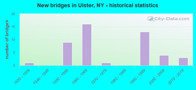
- New bridges - historical statistics
- 11930-1939
- 91950-1959
- 161960-1969
- 11970-1979
- 131990-1999
- 42000-2009
- 32010-2019
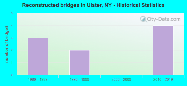
- Reconstructed bridges - Historical Statistics
- 31980-1989
- 21990-1999
- 02000-2009
- 42010-2019
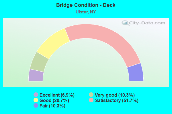
- Bridge Condition - Deck
- 6.9%Excellent
- 10.3%Very good
- 20.7%Good
- 51.7%Satisfactory
- 10.3%Fair
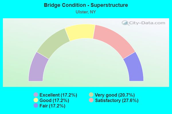
- Bridge Condition - Superstructure
- 17.2%Excellent
- 20.7%Very good
- 17.2%Good
- 27.6%Satisfactory
- 17.2%Fair
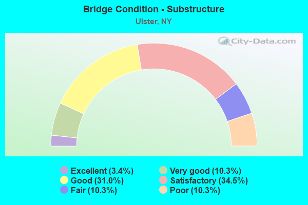
- Bridge Condition - Substructure
- 3.4%Excellent
- 10.3%Very good
- 31.0%Good
- 34.5%Satisfactory
- 10.3%Fair
- 10.3%Poor
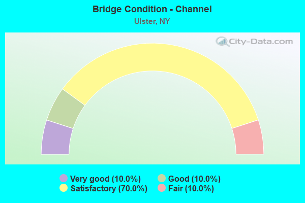
- Bridge Condition - Channel
- 10.0%Very good
- 10.0%Good
- 70.0%Satisfactory
- 10.0%Fair
Find on map >> Show street view
Structure Number: 1007361, Location: JCT. RTES. 9W & 209 (Lat: 41.974514, Lng: -73.989025), Route carried "on" structure: US 209, Year Built: 1960, Status: Open, Structure Length: 5.79m (19.00ft), Average Daily Traffic: 9,790 (year 2020), Truck Traffic: 6%, Average Future Daily Traffic: 13,811 (year 2040), Design Load: HS 20, Features Intersected: 9W 9W86033023 SB, RTE 9
Minimum Vertical Clearance: 30+ m (98+ ft), Kilometerpoint: 56.186, Lanes on structure: 3, Lanes under structure: 6, Base Highway Network: Yes, Owner: State Highway Agency, Approaching Roadway Width: 15.2m (49.9ft), Skew: 1 degrees, Material/Design: Steel, Design/Construction: Stringer/Multi-beam, Number Of Spans In Main Unit: 4, Length of Maximum Span: 17.0m (55.8ft), Curb or Sidewalk Widths: Left: 0.6m (2.0ft), Right: 0.6m (2.0ft), Curb-To-Curb Width: 12.8m (42.0ft), Out-to-Out Width: 14.4m (47.2ft)
Condition: Deck: Satisfactory, Superstructure: Satisfactory, Substructure: Good, Operating Rating: 72.6 metric tons, Method Used To Determine Operating Rating: Load Factor (LF), Inventory Rating: 43.5 metric tons, Method Used To Determine Inventory Rating: Load Factor (LF), Structural Evaluation: Equal to present minimum criteria, Deck Geometry: High priority of replacement, Underclear: High priority of corrective action, Approach Roadway Alignment: Equal to present desirable criteria, Length Of Structure Improvement: 5.79m (19.00ft), Designated Inspection Frequency: Every 24 months, Inspection Date: November 2021, Bridge Improvement Cost: $3,292,000, Roadway Improvement Cost: $1,928,000, Total Project Cost: $5,220,000 ( Estimate for 2021), Deck Structure Type: Concrete Cast-file-Place, Wearing Surface/Protective System: Wearing Surface: Bituminous, Membrane: Other
Find on map >> Show street view
Structure Number: 1007362, Location: JCT RTS 209+9W (Lat: 41.974353, Lng: -73.988839), Route carried "on" structure: US 209, Year Built: 1960, Status: Open, Structure Length: 5.79m (19.00ft), Average Daily Traffic: 9,790 (year 2020), Truck Traffic: 6%, Average Future Daily Traffic: 13,811 (year 2040), Design Load: HS 20, Features Intersected: 9W 9W86033023 SB, RTE 9
Minimum Vertical Clearance: 30+ m (98+ ft), Kilometerpoint: 56.186, Lanes on structure: 3, Lanes under structure: 6, Base Highway Network: Yes, Owner: State Highway Agency, Approaching Roadway Width: 9.4m (30.8ft), Skew: 1 degrees, Material/Design: Steel, Design/Construction: Stringer/Multi-beam, Number Of Spans In Main Unit: 4, Length of Maximum Span: 17.0m (55.8ft), Curb or Sidewalk Widths: Left: 0.6m (2.0ft), Right: 0.6m (2.0ft), Curb-To-Curb Width: 12.8m (42.0ft), Out-to-Out Width: 14.4m (47.2ft)
Condition: Deck: Satisfactory, Superstructure: Satisfactory, Substructure: Satisfactory, Operating Rating: 72.6 metric tons, Method Used To Determine Operating Rating: Load Factor (LF), Inventory Rating: 43.5 metric tons, Method Used To Determine Inventory Rating: Load Factor (LF), Structural Evaluation: Equal to present minimum criteria, Deck Geometry: High priority of replacement, Underclear: High priority of corrective action, Approach Roadway Alignment: Equal to present desirable criteria, Length Of Structure Improvement: 5.79m (19.00ft), Designated Inspection Frequency: Every 24 months, Inspection Date: November 2021, Bridge Improvement Cost: $3,292,000, Roadway Improvement Cost: $1,928,000, Total Project Cost: $5,220,000 ( Estimate for 2021), Deck Structure Type: Concrete Cast-file-Place, Wearing Surface/Protective System: Wearing Surface: Bituminous, Membrane: Other
Find on map >> Show street view
Structure Number: 10196, Location: 1.0 MI S JCT RTS 28+I87 (Lat: 41.939167, Lng: -74.018575), Route carried "on" structure: State highway 28, Year Built: 1960, Year Reconstructed: 1995, Status: Open, Structure Length: 10.70m (35.10ft), Average Daily Traffic: 13,525 (year 2019), Truck Traffic: 5%, Average Future Daily Traffic: 22,903 (year 2040), Design Load: HS 20+Mod, Features Intersected: ESOPUS CREEK
Minimum Vertical Clearance: 30+ m (98+ ft), Kilometerpoint: 0.965, Lanes on structure: 4, Base Highway Network: Yes, Owner: State Highway Agency, Approaching Roadway Width: 23.8m (78.1ft), Skew: 33 degrees, Material/Design: Steel continuous, Design/Construction: Stringer/Multi-beam, Number Of Spans In Main Unit: 3, Length of Maximum Span: 42.6m (139.8ft), Curb-To-Curb Width: 23.6m (77.4ft), Out-to-Out Width: 24.2m (79.4ft)
Condition: Deck: Satisfactory, Superstructure: Good, Substructure: Satisfactory, Channel: Satisfactory, Operating Rating: 55.4 metric tons, Method Used To Determine Operating Rating: Load and Resistance Factor Rating (LRFR) rating reported by rating factor(RF) method using HL-93 loadings, Inventory Rating: 42.8 metric tons, Method Used To Determine Inventory Rating: Load and Resistance Factor Rating (LRFR) rating reported by rating factor(RF) method using HL-93 loadings, Structural Evaluation: Equal to present minimum criteria, Deck Geometry: Superior to present desirable criteria, Waterway Adequacy: Equal to present desirable criteria, Approach Roadway Alignment: Equal to present desirable criteria, Length Of Structure Improvement: 10.69m (35.07ft), Designated Inspection Frequency: Every 24 months, Inspection Date: September 2021, Bridge Improvement Cost: $9,927,000, Roadway Improvement Cost: $5,813,000, Total Project Cost: $15,741,000 ( Estimate for 2021), Deck Structure Type: Concrete Cast-file-Place, Wearing Surface/Protective System: Wearing Surface: Integral Concrete, Deck Protection: Epoxy Coated Reinforcing
Find on map >> Show street view
Structure Number: 101961, Location: 0.6 MI S JCT RTS 28+I87 (Lat: 41.942239, Lng: -74.025669), Route carried "on" structure: County highway , Year Built: 2003, Status: Open, Structure Length: 4.15m (13.62ft), Average Daily Traffic: 7,351 (year 2017), Truck Traffic: 3%, Average Future Daily Traffic: 9,095 (year 2040), Design Load: HS 20, Features Intersected: 28 28 86012005WB, RTE 2, Facility Carried by Structure: COUNTY ROAD 31
Minimum Vertical Clearance: 30+ m (98+ ft), Kilometerpoint: 0.193, Lanes on structure: 2, Lanes under structure: 4, Owner: State Highway Agency, Approaching Roadway Width: 11.9m (39.0ft), Material/Design: Steel continuous, Design/Construction: Stringer/Multi-beam, Number Of Spans In Main Unit: 2, Length of Maximum Span: 20.1m (65.9ft), Curb-To-Curb Width: 12.0m (39.4ft), Out-to-Out Width: 13.0m (42.7ft)
Condition: Deck: Satisfactory, Superstructure: Very good, Substructure: Good, Operating Rating: 94.3 metric tons, Method Used To Determine Operating Rating: Load Factor (LF), Inventory Rating: 56.2 metric tons, Method Used To Determine Inventory Rating: Load Factor (LF), Structural Evaluation: Better than present minimum criteria, Deck Geometry: Somewhat better than minimum adequacy, Underclear: Equal to present minimum criteria, Approach Roadway Alignment: Equal to present desirable criteria, Length Of Structure Improvement: 4.14m (13.58ft), Designated Inspection Frequency: Every 24 months, Inspection Date: September 2021, Bridge Improvement Cost: $2,941,000, Roadway Improvement Cost: $1,722,000, Total Project Cost: $4,663,000 ( Estimate for 2021), Deck Structure Type: Concrete Cast-file-Place, Wearing Surface/Protective System: Wearing Surface: Integral Concrete, Deck Protection: Epoxy Coated Reinforcing
Find on map >> Show street view
Structure Number: 101962, Location: JCT S H 28 & I-87 (Lat: 41.945536, Lng: -74.030150), Route carried "on" structure: State highway 28, Year Built: 2000, Status: Open, Structure Length: 5.88m (19.29ft), Average Daily Traffic: 20,285 (year 2020), Truck Traffic: 9%, Average Future Daily Traffic: 20,380 (year 2040), Design Load: HS 25 or greater, Features Intersected: 87IX SB, RTE I87
Minimum Vertical Clearance: 30+ m (98+ ft), Kilometerpoint: 2.253, Lanes on structure: 4, Lanes under structure: 5, Base Highway Network: Yes, Owner: State Toll Authority, Approaching Roadway Width: 20.4m (66.9ft), Skew: 21 degrees, Material/Design: Steel continuous, Design/Construction: Stringer/Multi-beam, Number Of Spans In Main Unit: 2, Length of Maximum Span: 28.7m (94.2ft), Curb-To-Curb Width: 20.4m (66.9ft), Out-to-Out Width: 21.3m (69.9ft)
Condition: Deck: Good, Superstructure: Very good, Substructure: Good, Inventory Rating: 60.8 metric tons, Method Used To Determine Inventory Rating: Load Factor (LF), Structural Evaluation: Better than present minimum criteria, Deck Geometry: Superior to present desirable criteria, Underclear: High priority of corrective action, Approach Roadway Alignment: Equal to present desirable criteria, Length Of Structure Improvement: 5.88m (19.29ft), Designated Inspection Frequency: Every 24 months, Inspection Date: March 2021, Bridge Improvement Cost: $6,010,000, Roadway Improvement Cost: $3,519,000, Total Project Cost: $9,529,000 ( Estimate for 2021), Deck Structure Type: Concrete Cast-file-Place, Wearing Surface/Protective System: Wearing Surface: Integral Concrete, Deck Protection: Galvanized Reinforcing
Find on map >> Show street view
Structure Number: 1019631, Location: JCT RTS 28+209 (Lat: 41.948778, Lng: -74.035739), Route carried "on" structure: State highway 28, Year Built: 1962, Status: Open, Structure Length: 7.16m (23.49ft), Average Daily Traffic: 10,143 (year 2015), Truck Traffic: 6%, Average Future Daily Traffic: 10,190 (year 2040), Design Load: HS 20, Features Intersected: 209 209 86031315, RTE 20
Minimum Vertical Clearance: 30+ m (98+ ft), Kilometerpoint: 2.864, Lanes on structure: 3, Lanes under structure: 6, Base Highway Network: Yes, Owner: State Highway Agency, Approaching Roadway Width: 12.2m (40.0ft), Skew: 3 degrees, Material/Design: Steel, Design/Construction: Stringer/Multi-beam, Number Of Spans In Main Unit: 4, Length of Maximum Span: 22.6m (74.1ft), Curb-To-Curb Width: 12.8m (42.0ft), Out-to-Out Width: 13.8m (45.3ft)
Condition: Deck: Satisfactory, Superstructure: Fair, Substructure: Poor, Operating Rating: 69.7 metric tons, Method Used To Determine Operating Rating: Load and Resistance Factor Rating (LRFR) rating reported by rating factor(RF) method using HL-93 loadings, Inventory Rating: 53.8 metric tons, Method Used To Determine Inventory Rating: Load and Resistance Factor Rating (LRFR) rating reported by rating factor(RF) method using HL-93 loadings, Structural Evaluation: Meets minimum limits, Deck Geometry: Meets minimum limits, Underclear: High priority of corrective action, Approach Roadway Alignment: Equal to present desirable criteria, Length Of Structure Improvement: 7.16m (23.49ft), Designated Inspection Frequency: Every 24 months, Inspection Date: September 2020, Bridge Improvement Cost: $3,930,000, Roadway Improvement Cost: $2,302,000, Total Project Cost: $6,232,000 ( Estimate for 2021), Deck Structure Type: Concrete Cast-file-Place, Wearing Surface/Protective System: Wearing Surface: Bituminous, Membrane: Other
Find on map >> Show street view
Structure Number: 1019632, Location: JCT RTS 28+209 (Lat: 41.948933, Lng: -74.035803), Route carried "on" structure: State highway 28, Year Built: 1962, Status: Open, Structure Length: 7.16m (23.49ft), Average Daily Traffic: 10,143 (year 2015), Truck Traffic: 6%, Average Future Daily Traffic: 10,190 (year 2040), Design Load: HS 20, Features Intersected: 209 209 86031315 SB, RTE
Minimum Vertical Clearance: 30+ m (98+ ft), Kilometerpoint: 2.848, Lanes on structure: 3, Lanes under structure: 6, Base Highway Network: Yes, Owner: State Highway Agency, Approaching Roadway Width: 12.2m (40.0ft), Skew: 3 degrees, Material/Design: Steel, Design/Construction: Stringer/Multi-beam, Number Of Spans In Main Unit: 4, Length of Maximum Span: 22.6m (74.1ft), Curb-To-Curb Width: 12.8m (42.0ft), Out-to-Out Width: 13.8m (45.3ft)
Condition: Deck: Satisfactory, Superstructure: Fair, Substructure: Poor, Operating Rating: 69.3 metric tons, Method Used To Determine Operating Rating: Load and Resistance Factor Rating (LRFR) rating reported by rating factor(RF) method using HL-93 loadings, Inventory Rating: 53.5 metric tons, Method Used To Determine Inventory Rating: Load and Resistance Factor Rating (LRFR) rating reported by rating factor(RF) method using HL-93 loadings, Structural Evaluation: Meets minimum limits, Deck Geometry: Meets minimum limits, Underclear: High priority of corrective action, Approach Roadway Alignment: Equal to present desirable criteria, Length Of Structure Improvement: 7.16m (23.49ft), Designated Inspection Frequency: Every 24 months, Inspection Date: September 2021, Bridge Improvement Cost: $4,073,000, Roadway Improvement Cost: $2,385,000, Total Project Cost: $6,459,000 ( Estimate for 2021), Deck Structure Type: Concrete Cast-file-Place, Wearing Surface/Protective System: Wearing Surface: Bituminous, Membrane: Other
Find on map >> Show street view
Structure Number: 1022349, Location: JCT RTS 199 & 32 (Lat: 41.977517, Lng: -73.970939), Route carried "on" structure: State highway 199, Year Built: 1995, Status: Open, Structure Length: 5.00m (16.40ft), Average Daily Traffic: 18,078 (year 2019), Truck Traffic: 8%, Average Future Daily Traffic: 20,332 (year 2040), Design Load: HS 25 or greater, Features Intersected: RTE 32
Minimum Vertical Clearance: 30+ m (98+ ft), Kilometerpoint: 1.529, Lanes on structure: 5, Lanes under structure: 2, Base Highway Network: Yes, Owner: State Highway Agency, Approaching Roadway Width: 30.8m (101.0ft), Skew: 23 degrees, Material/Design: Steel continuous, Design/Construction: Stringer/Multi-beam, Number Of Spans In Main Unit: 3, Length of Maximum Span: 21.0m (68.9ft), Curb-To-Curb Width: 30.9m (101.4ft), Out-to-Out Width: 32.5m (106.6ft)
Condition: Deck: Satisfactory, Superstructure: Very good, Substructure: Satisfactory, Operating Rating: 46.7 metric tons, Method Used To Determine Operating Rating: Load and Resistance Factor Rating (LRFR) rating reported by rating factor(RF) method using HL-93 loadings, Inventory Rating: 36.0 metric tons, Method Used To Determine Inventory Rating: Load and Resistance Factor Rating (LRFR) rating reported by rating factor(RF) method using HL-93 loadings, Structural Evaluation: Equal to present minimum criteria, Deck Geometry: Superior to present desirable criteria, Underclear: Meets minimum limits, Approach Roadway Alignment: Equal to present desirable criteria, Length Of Structure Improvement: 4.99m (16.37ft), Designated Inspection Frequency: Every 24 months, Inspection Date: September 2020, Bridge Improvement Cost: $6,511,000, Roadway Improvement Cost: $3,813,000, Total Project Cost: $10,324,000 ( Estimate for 2021), Deck Structure Type: Concrete Cast-file-Place, Wearing Surface/Protective System: Wearing Surface: Integral Concrete, Deck Protection: Epoxy Coated Reinforcing
Find on map >> Show street view
Structure Number: 104079, Location: 1.6 MI S JCT RTS 209+28 (Lat: 41.935647, Lng: -74.053467), Route carried "on" structure: US 209, Year Built: 1962, Year Reconstructed: 2018, Status: Open, Structure Length: 8.47m (27.79ft), Average Daily Traffic: 10,787 (year 2019), Truck Traffic: 7%, Average Future Daily Traffic: 10,837 (year 2040), Design Load: HS 20, Features Intersected: ESOPUS CREEK
Minimum Vertical Clearance: 30+ m (98+ ft), Kilometerpoint: 48.222, Lanes on structure: 2, Base Highway Network: Yes, Owner: State Highway Agency, Approaching Roadway Width: 11.0m (36.1ft), Material/Design: Steel continuous, Design/Construction: Stringer/Multi-beam, Number Of Spans In Main Unit: 2, Length of Maximum Span: 42.0m (137.8ft), Curb-To-Curb Width: 11.0m (36.1ft), Out-to-Out Width: 12.0m (39.4ft)
Condition: Deck: Very good, Superstructure: Excellent, Substructure: Good, Channel: Good, Operating Rating: 85.3 metric tons, Method Used To Determine Operating Rating: Load Factor (LF), Inventory Rating: 50.8 metric tons, Method Used To Determine Inventory Rating: Load Factor (LF), Structural Evaluation: Better than present minimum criteria, Deck Geometry: Meets minimum limits, Waterway Adequacy: Equal to present minimum criteria, Approach Roadway Alignment: Equal to present desirable criteria, Length Of Structure Improvement: 8.47m (27.79ft), Designated Inspection Frequency: Every 24 months, Inspection Date: May 2021, Bridge Improvement Cost: $4,037,000, Roadway Improvement Cost: $2,364,000, Total Project Cost: $6,402,000 ( Estimate for 2021), Deck Structure Type: Concrete Cast-file-Place, Wearing Surface/Protective System: Wearing Surface: Integral Concrete, Deck Protection: Other Coated Reinforcing
Find on map >> Show street view
Structure Number: 1040801, Location: JCT RTS 209 & I87 (Lat: 41.976133, Lng: -74.011367), Route carried "on" structure: US 209, Year Built: 1995, Status: Open, Structure Length: 5.94m (19.49ft), Average Daily Traffic: 12,867 (year 2020), Truck Traffic: 5%, Average Future Daily Traffic: 18,151 (year 2040), Design Load: HS 25 or greater, Features Intersected: RTE I87
Minimum Vertical Clearance: 30+ m (98+ ft), Kilometerpoint: 54.304, Lanes on structure: 3, Lanes under structure: 4, Base Highway Network: Yes, Owner: State Highway Agency, Approaching Roadway Width: 16.5m (54.1ft), Skew: 2 degrees, Material/Design: Steel continuous, Design/Construction: Stringer/Multi-beam, Number Of Spans In Main Unit: 2, Length of Maximum Span: 28.9m (94.8ft), Curb-To-Curb Width: 16.2m (53.1ft), Out-to-Out Width: 17.2m (56.4ft)
Condition: Deck: Satisfactory, Superstructure: Satisfactory, Substructure: Satisfactory, Operating Rating: 25.6 metric tons, Method Used To Determine Operating Rating: Load and Resistance Factor Rating (LRFR) rating reported by rating factor(RF) method using HL-93 loadings, Inventory Rating: 19.8 metric tons, Method Used To Determine Inventory Rating: Load and Resistance Factor Rating (LRFR) rating reported by rating factor(RF) method using HL-93 loadings, Structural Evaluation: Somewhat better than minimum adequacy, Deck Geometry: Equal to present minimum criteria, Underclear: Equal to present minimum criteria, Approach Roadway Alignment: Equal to present desirable criteria, Length Of Structure Improvement: 5.94m (19.49ft), Designated Inspection Frequency: Every 24 months, Inspection Date: July 2020, Bridge Improvement Cost: $4,434,000, Roadway Improvement Cost: $2,596,000, Total Project Cost: $7,030,000 ( Estimate for 2021), Deck Structure Type: Concrete Cast-file-Place, Wearing Surface/Protective System: Wearing Surface: Integral Concrete, Deck Protection: Epoxy Coated Reinforcing
Find on map >> Show street view
Structure Number: 1040802, Location: JCT RTS 209 & I87 (Lat: 41.975994, Lng: -74.011419), Route carried "on" structure: US 209, Year Built: 1995, Status: Open, Structure Length: 5.94m (19.49ft), Average Daily Traffic: 12,867 (year 2020), Truck Traffic: 5%, Average Future Daily Traffic: 18,151 (year 2040), Design Load: HS 25 or greater, Features Intersected: RTE I87
Minimum Vertical Clearance: 30+ m (98+ ft), Kilometerpoint: 54.320, Lanes on structure: 3, Lanes under structure: 4, Base Highway Network: Yes, Owner: State Highway Agency, Approaching Roadway Width: 16.5m (54.1ft), Skew: 2 degrees, Material/Design: Steel continuous, Design/Construction: Stringer/Multi-beam, Number Of Spans In Main Unit: 2, Length of Maximum Span: 28.9m (94.8ft), Curb-To-Curb Width: 16.2m (53.1ft), Out-to-Out Width: 17.2m (56.4ft)
Condition: Deck: Satisfactory, Superstructure: Satisfactory, Substructure: Satisfactory, Operating Rating: 45.0 metric tons, Method Used To Determine Operating Rating: Load and Resistance Factor Rating (LRFR) rating reported by rating factor(RF) method using HL-93 loadings, Inventory Rating: 34.7 metric tons, Method Used To Determine Inventory Rating: Load and Resistance Factor Rating (LRFR) rating reported by rating factor(RF) method using HL-93 loadings, Structural Evaluation: Equal to present minimum criteria, Deck Geometry: Equal to present minimum criteria, Underclear: Equal to present minimum criteria, Approach Roadway Alignment: Equal to present desirable criteria, Length Of Structure Improvement: 5.94m (19.49ft), Designated Inspection Frequency: Every 24 months, Inspection Date: July 2020, Bridge Improvement Cost: $4,434,000, Roadway Improvement Cost: $2,596,000, Total Project Cost: $7,030,000 ( Estimate for 2021), Deck Structure Type: Concrete Cast-file-Place, Wearing Surface/Protective System: Wearing Surface: Integral Concrete, Deck Protection: Epoxy Coated Reinforcing
Find on map >> Show street view
Structure Number: 1040811, Location: .3 MILE E JCT US209 & I87 (Lat: 41.976186, Lng: -74.004633), Route carried "on" structure: US 209, Year Built: 1962, Year Reconstructed: 2018, Status: Open, Structure Length: 12.44m (40.81ft), Average Daily Traffic: 12,867 (year 2020), Truck Traffic: 5%, Average Future Daily Traffic: 18,151 (year 2040), Design Load: HL 93, Features Intersected: ESOPUS CREEK
Minimum Vertical Clearance: 30+ m (98+ ft), Kilometerpoint: 54.883, Lanes on structure: 2, Base Highway Network: Yes, Owner: State Highway Agency, Approaching Roadway Width: 11.3m (37.1ft), Skew: 2 degrees, Material/Design: Steel continuous, Design/Construction: Stringer/Multi-beam, Number Of Spans In Main Unit: 3, Length of Maximum Span: 48.8m (160.1ft), Curb-To-Curb Width: 11.3m (37.1ft), Out-to-Out Width: 12.3m (40.4ft)
Condition: Deck: Excellent, Superstructure: Excellent, Substructure: Very good, Channel: Satisfactory, Operating Rating: 58.6 metric tons, Method Used To Determine Operating Rating: Load and Resistance Factor Rating (LRFR) rating reported by rating factor(RF) method using HL-93 loadings, Inventory Rating: 45.4 metric tons, Method Used To Determine Inventory Rating: Load and Resistance Factor Rating (LRFR) rating reported by rating factor(RF) method using HL-93 loadings, Structural Evaluation: Equal to present desirable criteria, Deck Geometry: Somewhat better than minimum adequacy, Waterway Adequacy: Meets minimum limits, Approach Roadway Alignment: Equal to present desirable criteria, Length Of Structure Improvement: 12.43m (40.78ft), Designated Inspection Frequency: Every 24 months, Underwater Inspection Frequency: Every 60 months, Inspection Date: August 2020, Underwater Inspection Date: May 2020, Bridge Improvement Cost: $5,844,000, Roadway Improvement Cost: $3,422,000, Total Project Cost: $9,266,000 ( Estimate for 2021), Deck Structure Type: Concrete Cast-file-Place, Wearing Surface/Protective System: Wearing Surface: Integral Concrete, Deck Protection: Epoxy Coated Reinforcing
Find on map >> Show street view
Structure Number: 1040812, Location: .3 MILE E JCT US209 & I87 (Lat: 41.975989, Lng: -74.003417), Route carried "on" structure: US 209, Year Built: 1962, Year Reconstructed: 2018, Status: Open, Structure Length: 12.44m (40.81ft), Average Daily Traffic: 12,867 (year 2020), Truck Traffic: 5%, Average Future Daily Traffic: 18,151 (year 2040), Design Load: HL 93, Features Intersected: ESOPUS CREEK
Minimum Vertical Clearance: 30+ m (98+ ft), Kilometerpoint: 54.883, Lanes on structure: 2, Base Highway Network: Yes, Owner: State Highway Agency, Approaching Roadway Width: 12.7m (41.7ft), Skew: 2 degrees, Material/Design: Steel continuous, Design/Construction: Stringer/Multi-beam, Number Of Spans In Main Unit: 3, Length of Maximum Span: 48.8m (160.1ft), Curb-To-Curb Width: 11.3m (37.1ft), Out-to-Out Width: 12.3m (40.4ft)
Condition: Deck: Excellent, Superstructure: Excellent, Substructure: Good, Channel: Satisfactory, Operating Rating: 59.3 metric tons, Method Used To Determine Operating Rating: Load and Resistance Factor Rating (LRFR) rating reported by rating factor(RF) method using HL-93 loadings, Inventory Rating: 45.7 metric tons, Method Used To Determine Inventory Rating: Load and Resistance Factor Rating (LRFR) rating reported by rating factor(RF) method using HL-93 loadings, Structural Evaluation: Better than present minimum criteria, Deck Geometry: Somewhat better than minimum adequacy, Waterway Adequacy: Meets minimum limits, Approach Roadway Alignment: Equal to present desirable criteria, Length Of Structure Improvement: 12.43m (40.78ft), Designated Inspection Frequency: Every 24 months, Underwater Inspection Frequency: Every 60 months, Inspection Date: August 2020, Underwater Inspection Date: May 2020, Bridge Improvement Cost: $5,787,000, Roadway Improvement Cost: $3,389,000, Total Project Cost: $9,175,000 ( Estimate for 2021), Deck Structure Type: Concrete Cast-file-Place, Wearing Surface/Protective System: Wearing Surface: Integral Concrete, Deck Protection: Epoxy Coated Reinforcing
Find on map >> Show street view
Structure Number: 104082, Location: .6 MI E JCT US 209 & I87 (Lat: 41.975636, Lng: -73.999336), Route carried "on" structure: Other road , Year Built: 1962, Status: Open, Structure Length: 5.70m (18.70ft), Average Daily Traffic: 9,307 (year 2017), Truck Traffic: 4%, Average Future Daily Traffic: 11,306 (year 2040), Design Load: HS 20, Features Intersected: 209 209 86031345 WB, RTE, Facility Carried by Structure: Enterprise Drive
Minimum Vertical Clearance: 30+ m (98+ ft), Kilometerpoint: 1.866, Lanes on structure: 4, Lanes under structure: 5, Owner: State Highway Agency, Approaching Roadway Width: 14.6m (47.9ft), Skew: 1 degrees, Material/Design: Steel, Design/Construction: Stringer/Multi-beam, Number Of Spans In Main Unit: 4, Length of Maximum Span: 18.0m (59.1ft), Curb or Sidewalk Widths: Left: 0.5m (1.6ft), Right: 0.5m (1.6ft), Curb-To-Curb Width: 15.8m (51.8ft), Out-to-Out Width: 17.5m (57.4ft)
Condition: Deck: Satisfactory, Superstructure: Satisfactory, Substructure: Satisfactory, Channel: Satisfactory, Operating Rating: 82.6 metric tons, Method Used To Determine Operating Rating: Load Factor (LF), Inventory Rating: 49.9 metric tons, Method Used To Determine Inventory Rating: Load Factor (LF), Structural Evaluation: Equal to present minimum criteria, Deck Geometry: Meets minimum limits, Underclear: High priority of corrective action, Approach Roadway Alignment: Equal to present desirable criteria, Length Of Structure Improvement: 5.69m (18.67ft), Designated Inspection Frequency: Every 24 months, Inspection Date: May 2021, Bridge Improvement Cost: $5,031,000, Roadway Improvement Cost: $2,946,000, Total Project Cost: $7,977,000 ( Estimate for 2021), Deck Structure Type: Concrete Cast-file-Place, Wearing Surface/Protective System: Wearing Surface: Bituminous
Find on map >> Show street view
Structure Number: 1040831, Location: 1 MI E JCT U.S.209 & I87 (Lat: 41.974850, Lng: -73.991714), Route carried "on" structure: US 209, Year Built: 1962, Year Reconstructed: 1991, Status: Open, Structure Length: 4.75m (15.58ft), Average Daily Traffic: 9,790 (year 2020), Truck Traffic: 6%, Average Future Daily Traffic: 13,811 (year 2040), Design Load: HS 20, Features Intersected: CSX TRANS/ RVR LN
Minimum Vertical Clearance: 30+ m (98+ ft), Kilometerpoint: 55.961, Lanes on structure: 3, Base Highway Network: Yes, Owner: State Highway Agency, Approaching Roadway Width: 14.3m (46.9ft), Material/Design: Prestressed concrete, Design/Construction: Tee Beam, Number Of Spans In Main Unit: 3, Length of Maximum Span: 15.2m (49.9ft), Curb or Sidewalk Widths: Left: 0.6m (2.0ft), Right: 0.6m (2.0ft), Curb-To-Curb Width: 12.2m (40.0ft), Out-to-Out Width: 13.8m (45.3ft)
Condition: Deck: Good, Superstructure: Satisfactory, Substructure: Satisfactory, Operating Rating: 68.0 metric tons, Method Used To Determine Operating Rating: Load Factor (LF), Inventory Rating: 39.9 metric tons, Method Used To Determine Inventory Rating: Load Factor (LF), Structural Evaluation: Equal to present minimum criteria, Deck Geometry: High priority of replacement, Underclear: Equal to present minimum criteria, Approach Roadway Alignment: Equal to present desirable criteria, Length Of Structure Improvement: 4.75m (15.58ft), Designated Inspection Frequency: Every 24 months, Inspection Date: July 2021, Bridge Improvement Cost: $1,635,000, Roadway Improvement Cost: $957,000, Total Project Cost: $2,592,000 ( Estimate for 2021), Deck Structure Type: Concrete Cast-file-Place, Wearing Surface/Protective System: Wearing Surface: Bituminous, Membrane: Other
Find on map >> Show street view
Structure Number: 1040832, Location: 1 MI E JCT U.S.209 & I87 (Lat: 41.974706, Lng: -73.991714), Route carried "on" structure: US 209, Year Built: 1962, Year Reconstructed: 1991, Status: Open, Structure Length: 4.75m (15.58ft), Average Daily Traffic: 9,790 (year 2020), Truck Traffic: 6%, Average Future Daily Traffic: 13,811 (year 2040), Design Load: HS 20, Features Intersected: CSX TRANS/ RVR LN
Minimum Vertical Clearance: 30+ m (98+ ft), Kilometerpoint: 55.961, Lanes on structure: 3, Base Highway Network: Yes, Owner: State Highway Agency, Approaching Roadway Width: 14.3m (46.9ft), Material/Design: Prestressed concrete, Design/Construction: Tee Beam, Number Of Spans In Main Unit: 3, Length of Maximum Span: 15.2m (49.9ft), Curb or Sidewalk Widths: Left: 0.6m (2.0ft), Right: 0.6m (2.0ft), Curb-To-Curb Width: 12.2m (40.0ft), Out-to-Out Width: 13.8m (45.3ft)
Condition: Deck: Satisfactory, Superstructure: Satisfactory, Substructure: Fair, Operating Rating: 68.0 metric tons, Method Used To Determine Operating Rating: Load Factor (LF), Inventory Rating: 39.9 metric tons, Method Used To Determine Inventory Rating: Load Factor (LF), Structural Evaluation: Somewhat better than minimum adequacy, Deck Geometry: High priority of replacement, Underclear: Equal to present minimum criteria, Approach Roadway Alignment: Equal to present desirable criteria, Length Of Structure Improvement: 4.75m (15.58ft), Designated Inspection Frequency: Every 24 months, Inspection Date: July 2021, Bridge Improvement Cost: $1,635,000, Roadway Improvement Cost: $957,000, Total Project Cost: $2,592,000 ( Estimate for 2021), Deck Structure Type: Concrete Cast-file-Place, Wearing Surface/Protective System: Wearing Surface: Bituminous, Membrane: Other
Find on map >> Show street view
Structure Number: 105044, Location: 1 MI S JCT US 9W & US 209 (Lat: 41.959008, Lng: -73.992342), Route carried "on" structure: State highway 981M, Year Built: 1998, Status: Open, Structure Length: 3.47m (11.38ft), Average Daily Traffic: 18,962 (year 2016), Truck Traffic: 2%, Average Future Daily Traffic: 19,051 (year 2040), Design Load: HS 25 or greater, Features Intersected: CSXT RIVER LINE
Minimum Vertical Clearance: 30+ m (98+ ft), Kilometerpoint: 1.641, Lanes on structure: 4, Base Highway Network: Yes, Owner: State Highway Agency, Approaching Roadway Width: 14.3m (46.9ft), Skew: 4 degrees, Material/Design: Steel, Design/Construction: Stringer/Multi-beam, Number Of Spans In Main Unit: 1, Length of Maximum Span: 32.6m (107.0ft), Curb or Sidewalk Widths: Left: 1.5m (4.9ft), Right: 0.0m, Curb-To-Curb Width: 14.4m (47.2ft), Out-to-Out Width: 16.6m (54.5ft)
Condition: Deck: Very good, Superstructure: Very good, Substructure: Good, Operating Rating: 93.4 metric tons, Method Used To Determine Operating Rating: Load Factor (LF), Inventory Rating: 56.2 metric tons, Method Used To Determine Inventory Rating: Load Factor (LF), Structural Evaluation: Better than present minimum criteria, Deck Geometry: High priority of replacement, Underclear: Somewhat better than minimum adequacy, Approach Roadway Alignment: Equal to present desirable criteria, Length Of Structure Improvement: 3.47m (11.38ft), Designated Inspection Frequency: Every 24 months, Inspection Date: August 2021, Bridge Improvement Cost: $4,832,000, Roadway Improvement Cost: $2,830,000, Total Project Cost: $7,662,000 ( Estimate for 2021), Deck Structure Type: Concrete Cast-file-Place, Wearing Surface/Protective System: Wearing Surface: Integral Concrete, Deck Protection: Epoxy Coated Reinforcing
Find on map >> Show street view
Structure Number: 1091321, Location: .2 MI W JCT US 209 & I87 (Lat: 41.975900, Lng: -74.014303), Route carried "on" structure: US 209, Year Built: 1995, Status: Open, Structure Length: 2.87m (9.42ft), Average Daily Traffic: 12,867 (year 2020), Truck Traffic: 8%, Average Future Daily Traffic: 18,151 (year 2040), Design Load: HS 25 or greater, Features Intersected: CR 31-SAWKILL RD
Minimum Vertical Clearance: 30+ m (98+ ft), Kilometerpoint: 54.078, Lanes on structure: 2, Lanes under structure: 2, Base Highway Network: Yes, Owner: State Highway Agency, Approaching Roadway Width: 13.7m (44.9ft), Skew: 1 degrees, Material/Design: Steel, Design/Construction: Stringer/Multi-beam, Number Of Spans In Main Unit: 1, Length of Maximum Span: 28.0m (91.9ft), Curb-To-Curb Width: 13.8m (45.3ft), Out-to-Out Width: 14.8m (48.6ft)
Condition: Deck: Satisfactory, Superstructure: Very good, Substructure: Good, Operating Rating: 82.6 metric tons, Method Used To Determine Operating Rating: Load Factor (LF), Inventory Rating: 49.9 metric tons, Method Used To Determine Inventory Rating: Load Factor (LF), Structural Evaluation: Better than present minimum criteria, Deck Geometry: Superior to present desirable criteria, Underclear: Somewhat better than minimum adequacy, Approach Roadway Alignment: Equal to present desirable criteria, Length Of Structure Improvement: 2.86m (9.38ft), Designated Inspection Frequency: Every 24 months, Inspection Date: May 2020, Bridge Improvement Cost: $2,410,000, Roadway Improvement Cost: $1,411,000, Total Project Cost: $3,822,000 ( Estimate for 2021), Deck Structure Type: Concrete Cast-file-Place, Wearing Surface/Protective System: Wearing Surface: Integral Concrete, Deck Protection: Epoxy Coated Reinforcing
Find on map >> Show street view
Structure Number: 1091322, Location: .2 MI W JCT US 209 & I87 (Lat: 41.975769, Lng: -74.014297), Route carried "on" structure: US 209, Year Built: 1995, Status: Open, Structure Length: 2.93m (9.61ft), Average Daily Traffic: 12,867 (year 2020), Truck Traffic: 8%, Average Future Daily Traffic: 18,151 (year 2040), Design Load: HS 25 or greater, Features Intersected: CR 31-SAWKILL RD
Minimum Vertical Clearance: 30+ m (98+ ft), Kilometerpoint: 54.078, Lanes on structure: 2, Lanes under structure: 2, Base Highway Network: Yes, Owner: State Highway Agency, Approaching Roadway Width: 14.0m (45.9ft), Skew: 1 degrees, Material/Design: Steel, Design/Construction: Stringer/Multi-beam, Number Of Spans In Main Unit: 1, Length of Maximum Span: 28.0m (91.9ft), Curb-To-Curb Width: 13.8m (45.3ft), Out-to-Out Width: 14.8m (48.6ft)
Condition: Deck: Satisfactory, Superstructure: Good, Substructure: Good, Operating Rating: 85.3 metric tons, Method Used To Determine Operating Rating: Load Factor (LF), Inventory Rating: 50.8 metric tons, Method Used To Determine Inventory Rating: Load Factor (LF), Structural Evaluation: Better than present minimum criteria, Deck Geometry: Superior to present desirable criteria, Underclear: Somewhat better than minimum adequacy, Approach Roadway Alignment: Equal to present desirable criteria, Length Of Structure Improvement: 2.92m (9.58ft), Designated Inspection Frequency: Every 24 months, Inspection Date: May 2020, Bridge Improvement Cost: $2,505,000, Roadway Improvement Cost: $1,467,000, Total Project Cost: $3,972,000 ( Estimate for 2021), Deck Structure Type: Concrete Cast-file-Place, Wearing Surface/Protective System: Wearing Surface: Integral Concrete, Deck Protection: Epoxy Coated Reinforcing
Find on map >> Show street view
Structure Number: 334657, Location: 4.5 MI SW OF SAUGERTIES (Lat: 42.019533, Lng: -73.996636), Route carried "on" structure: County highway , Year Built: 1931, Year Reconstructed: 2015, Status: Open, Structure Length: 3.87m (12.70ft), Average Daily Traffic: 4,256 (year 2018), Truck Traffic: 6%, Average Future Daily Traffic: 5,265 (year 2040), Design Load: HL 93, Features Intersected: PLATTEKILL CREEK, Facility Carried by Structure: COUNTY ROAD 31
Minimum Vertical Clearance: 30+ m (98+ ft), Kilometerpoint: 4.248, Lanes on structure: 2, Owner: County Highway Agency, Approaching Roadway Width: 6.4m (21.0ft), Material/Design: Steel, Design/Construction: Truss - Thru, Number Of Spans In Main Unit: 1, Length of Maximum Span: 37.8m (124.0ft), Curb-To-Curb Width: 7.9m (25.9ft), Out-to-Out Width: 8.1m (26.6ft)
Condition: Deck: Satisfactory, Superstructure: Very good, Substructure: Satisfactory, Channel: Fair, Operating Rating: 18.8 metric tons, Method Used To Determine Operating Rating: Load and Resistance Factor Rating (LRFR) rating reported by rating factor(RF) method using HL-93 loadings, Inventory Rating: 14.6 metric tons, Method Used To Determine Inventory Rating: Load and Resistance Factor Rating (LRFR) rating reported by rating factor(RF) method using HL-93 loadings, Structural Evaluation: Meets minimum limits, Deck Geometry: High priority of corrective action, Waterway Adequacy: Meets minimum limits, Approach Roadway Alignment: Equal to present desirable criteria, Length Of Structure Improvement: 3.87m (12.70ft), Designated Inspection Frequency: Every 24 months, Critical Feature Inspection Frequency: Every 24 months, Underwater Inspection Frequency: Every 60 months, Inspection Date: July 2021, Critical Feature Inspection Date: July 2021, Underwater Inspection Date: June 2019, Bridge Improvement Cost: $3,017,000, Roadway Improvement Cost: $1,767,000, Total Project Cost: $4,784,000 ( Estimate for 2021), Deck Structure Type: Concrete Precast Panels, Wearing Surface/Protective System: Wearing Surface: Bituminous
Find on map >> Show street view
Structure Number: 334753, Location: 0.6 MI N OF LAKE KATRINE (Lat: 41.994756, Lng: -73.997847), Route carried "on" structure: County highway , Year Built: 1972, Status: Open, Structure Length: 11.83m (38.81ft), Average Daily Traffic: 5,078 (year 2018), Truck Traffic: 3%, Average Future Daily Traffic: 6,283 (year 2040), Design Load: HS 20, Features Intersected: ESOPUS CREEK, Facility Carried by Structure: LEGGS MILL ROAD
Minimum Vertical Clearance: 30+ m (98+ ft), Kilometerpoint: 1.255, Lanes on structure: 2, Owner: County Highway Agency, Approaching Roadway Width: 6.4m (21.0ft), Skew: 2 degrees, Material/Design: Steel, Design/Construction: Stringer/Multi-beam, Number Of Spans In Main Unit: 4, Length of Maximum Span: 28.9m (94.8ft), Curb or Sidewalk Widths: Left: 1.3m (4.3ft), Right: 0.0m, Curb-To-Curb Width: 7.9m (25.9ft), Out-to-Out Width: 10.1m (33.1ft)
Condition: Deck: Fair, Superstructure: Satisfactory, Substructure: Poor, Channel: Satisfactory, Operating Rating: 70.8 metric tons, Method Used To Determine Operating Rating: Load Factor (LF), Inventory Rating: 42.6 metric tons, Method Used To Determine Inventory Rating: Load Factor (LF), Structural Evaluation: Meets minimum limits, Deck Geometry: High priority of corrective action, Waterway Adequacy: Meets minimum limits, Approach Roadway Alignment: Equal to present minimum criteria, Length Of Structure Improvement: 11.82m (38.78ft), Designated Inspection Frequency: Every 24 months, Inspection Date: October 2020, Bridge Improvement Cost: $5,059,000, Roadway Improvement Cost: $2,962,000, Total Project Cost: $8,021,000 ( Estimate for 2021), Deck Structure Type: Concrete Cast-file-Place, Wearing Surface/Protective System: Wearing Surface: Bituminous
Find on map >> Show street view
Structure Number: 334763, Location: 3.5 MILES N OF KINGSTON (Lat: 41.979806, Lng: -74.013794), Route carried "on" structure: County highway , Year Built: 2016, Status: Open, Structure Length: 4.42m (14.50ft), Average Daily Traffic: 6,187 (year 2018), Truck Traffic: 4%, Average Future Daily Traffic: 7,655 (year 2040), Design Load: HL 93, Features Intersected: SAW KILL, Facility Carried by Structure: COUNTY ROAD 31
Minimum Vertical Clearance: 30+ m (98+ ft), Kilometerpoint: 4.650, Lanes on structure: 2, Owner: County Highway Agency, Approaching Roadway Width: 6.7m (22.0ft), Material/Design: Steel, Design/Construction: Stringer/Multi-beam, Number Of Spans In Main Unit: 1, Length of Maximum Span: 42.1m (138.1ft), Curb-To-Curb Width: 12.2m (40.0ft), Out-to-Out Width: 13.2m (43.3ft)
Condition: Deck: Good, Superstructure: Good, Substructure: Very good, Channel: Satisfactory, Operating Rating: 76.2 metric tons, Method Used To Determine Operating Rating: Load Factor (LF), Inventory Rating: 45.4 metric tons, Method Used To Determine Inventory Rating: Load Factor (LF), Structural Evaluation: Better than present minimum criteria, Deck Geometry: Somewhat better than minimum adequacy, Waterway Adequacy: Equal to present desirable criteria, Approach Roadway Alignment: Equal to present desirable criteria, Length Of Structure Improvement: 4.41m (14.47ft), Designated Inspection Frequency: Every 24 months, Inspection Date: October 2020, Bridge Improvement Cost: $2,665,000, Roadway Improvement Cost: $1,561,000, Total Project Cost: $4,226,000 ( Estimate for 2021), Deck Structure Type: Concrete Cast-file-Place, Wearing Surface/Protective System: Wearing Surface: Integral Concrete, Deck Protection: Epoxy Coated Reinforcing
Find on map >> Show street view
Structure Number: 504001, Location: JCT RT 199 < HUDSON R (Lat: 41.974956, Lng: -73.937708), Route carried "on" structure: State highway 199, Year Built: 1957, Year Reconstructed: 2002, Status: Posted for load, Structure Length: 237.53m (779.30ft), Average Daily Traffic: 19,525 (year 2018), Truck Traffic: 5%, Average Future Daily Traffic: 19,710 (year 2040), Design Load: HS 20, Features Intersected: COUNTY ROAD 37, HUDSON R
Minimum Vertical Clearance: 30+ m (98+ ft), Kilometerpoint: 0.000, Lanes on structure: 2, Lanes under structure: 2, Base Highway Network: Yes, Toll: Toll bridge, Owner: State Toll Authority, Approaching Roadway Width: 12.5m (41.0ft), Navigation Control: Yes ( Vertical Clearance: 40.2m (131.9ft), Horizontal Clearance: 236.5m (775.9ft)), Material/Design: Steel continuous, Design/Construction: Truss - Deck, Number Of Spans In Main Unit: 10, Number Of Approach Spans: 21, Length of Maximum Span: 243.8m (799.9ft), Curb or Sidewalk Widths: Left: 0.0m, Right: 1.2m (3.9ft), Curb-To-Curb Width: 10.4m (34.1ft), Out-to-Out Width: 13.2m (43.3ft)
Condition: Deck: Good, Superstructure: Good, Substructure: Fair, Channel: Very good, Operating Rating: 91.4 metric tons, Method Used To Determine Operating Rating: Field evaluation and documented engineering judgment, Inventory Rating: 32.7 metric tons, Method Used To Determine Inventory Rating: Field evaluation and documented engineering judgment, Structural Evaluation: Somewhat better than minimum adequacy, Deck Geometry: Meets minimum limits, Underclear: Meets minimum limits, Waterway Adequacy: Somewhat better than minimum adequacy, Approach Roadway Alignment: Equal to present desirable criteria, Length Of Structure Improvement: 237.53m (779.30ft), Designated Inspection Frequency: Every 24 months, Critical Feature Inspection Frequency: Every 24 months, Underwater Inspection Frequency: Every 60 months, Inspection Date: June 2021, Critical Feature Inspection Date: June 2021, Underwater Inspection Date: May 2017, Bridge Improvement Cost: $200,624,000, Roadway Improvement Cost: $117,486,000, Total Project Cost: $318,110,000 ( Estimate for 2021), Deck Structure Type: Other, Wearing Surface/Protective System: Wearing Surface: Bituminous
Find on map >> Show street view
Structure Number: 551546, Location: 1.7 MI SW OF KINGSTON (Lat: 41.921719, Lng: -74.044633), Route carried "on" structure: County highway , Year Built: 1953, Status: Open, Structure Length: 7.71m (25.30ft), Average Daily Traffic: 5,494 (year 2018), Truck Traffic: 3%, Average Future Daily Traffic: 6,674 (year 2040), Design Load: HS 20+Mod, Features Intersected: I-87 NB, RTE I87, Facility Carried by Structure: LUCAS AVE
Minimum Vertical Clearance: 30+ m (98+ ft), Kilometerpoint: 4.183, Lanes on structure: 2, Lanes under structure: 4, Owner: State Toll Authority, Approaching Roadway Width: 9.8m (32.2ft), Skew: 3 degrees, Material/Design: Steel, Design/Construction: Stringer/Multi-beam, Number Of Spans In Main Unit: 4, Length of Maximum Span: 22.6m (74.1ft), Curb or Sidewalk Widths: Left: 0.8m (2.6ft), Right: 0.8m (2.6ft), Curb-To-Curb Width: 9.8m (32.2ft), Out-to-Out Width: 11.9m (39.0ft)
Condition: Deck: Satisfactory, Superstructure: Fair, Substructure: Fair, Operating Rating: 37.6 metric tons, Method Used To Determine Operating Rating: Load and Resistance Factor Rating (LRFR) rating reported by rating factor(RF) method using HL-93 loadings, Inventory Rating: 28.8 metric tons, Method Used To Determine Inventory Rating: Load and Resistance Factor Rating (LRFR) rating reported by rating factor(RF) method using HL-93 loadings, Structural Evaluation: Somewhat better than minimum adequacy, Deck Geometry: Meets minimum limits, Underclear: High priority of corrective action, Approach Roadway Alignment: Equal to present minimum criteria, Length Of Structure Improvement: 7.71m (25.30ft), Designated Inspection Frequency: Every 24 months, Inspection Date: April 2020, Bridge Improvement Cost: $3,520,000, Roadway Improvement Cost: $2,061,000, Total Project Cost: $5,581,000 ( Estimate for 2021), Deck Structure Type: Concrete Cast-file-Place, Wearing Surface/Protective System: Wearing Surface: Bituminous, Membrane: Other
Find on map >> Show street view
Structure Number: 551551, Location: KINGSTON EXIT 19 OF I87 (Lat: 41.948078, Lng: -74.026658), Route carried "on" structure: Ramp Other road , Year Built: 1999, Status: Open, Structure Length: 6.77m (22.21ft), Average Daily Traffic: 3,071 (year 2019), Truck Traffic: 15%, Average Future Daily Traffic: 5,200 (year 2040), Design Load: HS 25 or greater, Features Intersected: I-87 SB, RTE I87, Facility Carried by Structure: THRUWAY KINGSTON I
Minimum Vertical Clearance: 30+ m (98+ ft), Kilometerpoint: 0.901, Lanes on structure: 2, Lanes under structure: 5, Toll: On Interstate toll segment, Owner: State Toll Authority, Approaching Roadway Width: 14.9m (48.9ft), Skew: 30 degrees, Material/Design: Steel continuous, Design/Construction: Stringer/Multi-beam, Number Of Spans In Main Unit: 2, Length of Maximum Span: 33.5m (109.9ft), Curb-To-Curb Width: 14.8m (48.6ft), Out-to-Out Width: 15.9m (52.2ft)
Condition: Deck: Very good, Superstructure: Excellent, Substructure: Very good, Operating Rating: 79.8 metric tons, Method Used To Determine Operating Rating: Load Factor (LF), Inventory Rating: 47.2 metric tons, Method Used To Determine Inventory Rating: Load Factor (LF), Structural Evaluation: Equal to present desirable criteria, Deck Geometry: Superior to present desirable criteria, Underclear: High priority of corrective action, Approach Roadway Alignment: Equal to present desirable criteria, Length Of Structure Improvement: 6.76m (22.18ft), Designated Inspection Frequency: Every 24 months, Inspection Date: March 2020, Bridge Improvement Cost: $3,903,000, Roadway Improvement Cost: $2,285,000, Total Project Cost: $6,188,000 ( Estimate for 2021), Deck Structure Type: Concrete Cast-file-Place, Wearing Surface/Protective System: Wearing Surface: Integral Concrete, Deck Protection: Galvanized Reinforcing
Find on map >> Show street view
Structure Number: 551552, Location: 1.7 MI N OF KINGSTON (Lat: 41.953103, Lng: -74.019539), Route carried "on" structure: County highway , Year Built: 2016, Status: Open, Structure Length: 6.89m (22.60ft), Average Daily Traffic: 7,351 (year 2017), Truck Traffic: 3%, Average Future Daily Traffic: 9,095 (year 2040), Design Load: HS 25 or greater, Features Intersected: 87IX, RTE I87, Facility Carried by Structure: CR 31
Minimum Vertical Clearance: 30+ m (98+ ft), Kilometerpoint: 1.577, Lanes on structure: 2, Lanes under structure: 4, Owner: State Toll Authority, Approaching Roadway Width: 10.4m (34.1ft), Skew: 3 degrees, Material/Design: Steel continuous, Design/Construction: Stringer/Multi-beam, Number Of Spans In Main Unit: 2, Length of Maximum Span: 33.5m (109.9ft), Curb-To-Curb Width: 10.4m (34.1ft), Out-to-Out Width: 11.3m (37.1ft)
Condition: Deck: Good, Superstructure: Excellent, Substructure: Excellent, Operating Rating: 60.6 metric tons, Method Used To Determine Operating Rating: Load and Resistance Factor Rating (LRFR) rating reported by rating factor(RF) method using HL-93 loadings, Inventory Rating: 46.7 metric tons, Method Used To Determine Inventory Rating: Load and Resistance Factor Rating (LRFR) rating reported by rating factor(RF) method using HL-93 loadings, Structural Evaluation: Superior to present desirable criteria, Deck Geometry: Meets minimum limits, Underclear: Equal to present minimum criteria, Approach Roadway Alignment: Equal to present desirable criteria, Length Of Structure Improvement: 6.88m (22.57ft), Designated Inspection Frequency: Every 24 months, Inspection Date: November 2020, Bridge Improvement Cost: $3,675,000, Roadway Improvement Cost: $2,152,000, Total Project Cost: $5,827,000 ( Estimate for 2021), Deck Structure Type: Concrete Cast-file-Place, Wearing Surface/Protective System: Wearing Surface: Integral Concrete, Deck Protection: Galvanized Reinforcing
Find on map >> Show street view
Structure Number: 5515539, Location: 0.3 MI N JCT I-87 < 209 (Lat: 41.980731, Lng: -74.009628), Route carried "on" structure: Interstate 87, Year Built: 1950, Status: Open, Structure Length: 5.58m (18.31ft), Average Daily Traffic: 30,496 (year 2018), Truck Traffic: 19%, Average Future Daily Traffic: 51,641 (year 2040), Design Load: HS 20+Mod, Features Intersected: SAW KILL
Minimum Vertical Clearance: 30+ m (98+ ft), Kilometerpoint: 44.103, Lanes on structure: 4, Base Highway Network: Yes, Toll: On Interstate toll segment, Owner: State Toll Authority, Approaching Roadway Width: 34.1m (111.9ft), Skew: 33 degrees, Material/Design: Steel, Design/Construction: Stringer/Multi-beam, Number Of Spans In Main Unit: 2, Length of Maximum Span: 27.1m (88.9ft), Curb-To-Curb Width: 33.6m (110.2ft), Out-to-Out Width: 34.4m (112.9ft)
Condition: Deck: Good, Superstructure: Good, Substructure: Good, Channel: Satisfactory, Operating Rating: 68.9 metric tons, Method Used To Determine Operating Rating: Load Factor (LF), Inventory Rating: 41.7 metric tons, Method Used To Determine Inventory Rating: Load Factor (LF), Structural Evaluation: Better than present minimum criteria, Deck Geometry: Superior to present desirable criteria, Waterway Adequacy: Superior to present desirable criteria, Approach Roadway Alignment: Equal to present desirable criteria, Length Of Structure Improvement: 5.57m (18.27ft), Designated Inspection Frequency: Every 24 months, Inspection Date: June 2020, Bridge Improvement Cost: $9,481,000, Roadway Improvement Cost: $5,552,000, Total Project Cost: $15,033,000 ( Estimate for 2021), Deck Structure Type: Concrete Cast-file-Place, Wearing Surface/Protective System: Wearing Surface: Bituminous, Membrane: Other
Find on map >> Show street view
Structure Number: 551554, Location: 1.0 MI.NW OF LAKE KATRINE (Lat: 42.000297, Lng: -74.003300), Route carried "on" structure: County highway , Year Built: 1950, Status: Open, Structure Length: 8.41m (27.59ft), Average Daily Traffic: 3,225 (year 2018), Truck Traffic: 5%, Average Future Daily Traffic: 3,990 (year 2040), Design Load: HS 20+Mod, Features Intersected: I-87 SB, RTE I87, Facility Carried by Structure: CR 90
Minimum Vertical Clearance: 30+ m (98+ ft), Kilometerpoint: 2.542, Lanes on structure: 2, Lanes under structure: 4, Owner: State Toll Authority, Approaching Roadway Width: 10.4m (34.1ft), Skew: 3 degrees, Material/Design: Steel, Design/Construction: Stringer/Multi-beam, Number Of Spans In Main Unit: 4, Length of Maximum Span: 25.9m (85.0ft), Curb or Sidewalk Widths: Left: 0.7m (2.3ft), Right: 0.7m (2.3ft), Curb-To-Curb Width: 10.4m (34.1ft), Out-to-Out Width: 12.5m (41.0ft)
Condition: Deck: Fair, Superstructure: Fair, Substructure: Satisfactory, Operating Rating: 34.5 metric tons, Method Used To Determine Operating Rating: Load Factor (LF), Inventory Rating: 18.1 metric tons, Method Used To Determine Inventory Rating: Load Factor (LF), Structural Evaluation: Somewhat better than minimum adequacy, Deck Geometry: Somewhat better than minimum adequacy, Underclear: High priority of corrective action, Approach Roadway Alignment: Somewhat better than minimum adequacy, Length Of Structure Improvement: 8.41m (27.59ft), Designated Inspection Frequency: Every 24 months, Inspection Date: April 2020, Bridge Improvement Cost: $4,001,000, Roadway Improvement Cost: $2,343,000, Total Project Cost: $6,344,000 ( Estimate for 2021), Deck Structure Type: Concrete Cast-file-Place, Wearing Surface/Protective System: Wearing Surface: Bituminous, Membrane: Other
Find on map >> Show street view
Structure Number: 551555, Location: 4.0 MI SW OF SAUGERTIES (Lat: 42.018606, Lng: -73.998233), Route carried "on" structure: Other road , Year Built: 1950, Year Reconstructed: 1993, Status: Open, Structure Length: 6.40m (21.00ft), Average Daily Traffic: 1,249 (year 2018), Truck Traffic: 4%, Average Future Daily Traffic: 1,749 (year 2038), Design Load: HS 20+Mod, Features Intersected: I-87 SB, RTE I87, Facility Carried by Structure: SHEEHAN LANE
Minimum Vertical Clearance: 30+ m (98+ ft), Kilometerpoint: 0.113, Lanes on structure: 2, Lanes under structure: 4, Owner: State Toll Authority, Approaching Roadway Width: 7.9m (25.9ft), Skew: 2 degrees, Material/Design: Steel, Design/Construction: Stringer/Multi-beam, Number Of Spans In Main Unit: 4, Length of Maximum Span: 18.9m (62.0ft), Curb or Sidewalk Widths: Left: 0.6m (2.0ft), Right: 0.6m (2.0ft), Curb-To-Curb Width: 7.9m (25.9ft), Out-to-Out Width: 9.9m (32.5ft)
Condition: Deck: Fair, Superstructure: Fair, Substructure: Satisfactory, Operating Rating: 37.2 metric tons, Method Used To Determine Operating Rating: Load Factor (LF), Inventory Rating: 19.1 metric tons, Method Used To Determine Inventory Rating: Load Factor (LF), Structural Evaluation: Somewhat better than minimum adequacy, Deck Geometry: Meets minimum limits, Underclear: High priority of corrective action, Approach Roadway Alignment: Equal to present minimum criteria, Length Of Structure Improvement: 6.40m (21.00ft), Designated Inspection Frequency: Every 24 months, Critical Feature Inspection Frequency: Every 24 months, Inspection Date: April 2020, Critical Feature Inspection Date: April 2020, Bridge Improvement Cost: $2,485,000, Roadway Improvement Cost: $1,455,000, Total Project Cost: $3,940,000 ( Estimate for 2021), Deck Structure Type: Concrete Cast-file-Place, Wearing Surface/Protective System: Wearing Surface: Integral Concrete
Find on map >> Show street view
Structure Number: 1007361, Location: JCT. RTES. 9W & 209 (Lat: 41.974514, Lng: -73.989025), Route carried "under" structure: US 9W, Year Built: 1960, Structure Length: 0. m, Average Daily Traffic: 20,400 (year 1978), Features Intersected: 9W 9W86033023 SB, RTE 9, Facility Carried by Structure: RTE 209
Minimum Vertical Clearance: 4.52m (14.83ft), Kilometerpoint: 3.717, Lanes on structure: 3, Lanes under structure: 3, Material/Design: Steel, Design/Construction: Stringer/Multi-beam, Length of Maximum Span: 17.0m (55.8ft)
Find on map >> Show street view
Structure Number: 1007362, Location: JCT RTS 209+9W (Lat: 41.974353, Lng: -73.988839), Route carried "under" structure: US 9W, Year Built: 1960, Structure Length: 0. m, Average Daily Traffic: 20,400 (year 1978), Features Intersected: 9W 9W86033023 SB, RTE 9, Facility Carried by Structure: RTE 209
Minimum Vertical Clearance: 4.57m (14.99ft), Kilometerpoint: 3.717, Lanes on structure: 3, Lanes under structure: 3, Material/Design: Steel, Design/Construction: Stringer/Multi-beam, Length of Maximum Span: 17.0m (55.8ft)
Find on map >> Show street view
Structure Number: 101961, Location: 0.6 MI S JCT RTS 28+I87 (Lat: 41.942239, Lng: -74.025669), Route carried "under" structure: Interstate 28, Year Built: 2003, Structure Length: 0. m, Average Daily Traffic: 24,215 (year 1999), Features Intersected: 28 28 86012005WB, RTE 2, Facility Carried by Structure: COUNTY ROAD 31
Minimum Vertical Clearance: 5.49m (18.01ft), Kilometerpoint: 0.724, Lanes on structure: 2, Lanes under structure: 2, Material/Design: Steel continuous, Design/Construction: Stringer/Multi-beam, Length of Maximum Span: 20.1m (65.9ft)
Find on map >> Show street view
Structure Number: 101962, Location: JCT S H 28 & I-87 (Lat: 41.945536, Lng: -74.030150), Route carried "under" structure: Interstate 87, Year Built: 2000, Structure Length: 0. m, Average Daily Traffic: 36,326 (year 1998), Features Intersected: 87IX SB, RTE I87, Facility Carried by Structure: RTE 28
Minimum Vertical Clearance: 5.33m (17.49ft), Kilometerpoint: 146.628, Lanes on structure: 4, Lanes under structure: 3, Toll: On Interstate toll segment, Material/Design: Steel continuous, Design/Construction: Stringer/Multi-beam, Length of Maximum Span: 28.7m (94.2ft)
Find on map >> Show street view
Structure Number: 1019631, Location: JCT RTS 28+209 (Lat: 41.948778, Lng: -74.035739), Route carried "under" structure: US 209, Year Built: 1962, Structure Length: 0. m, Average Daily Traffic: 12,152 (year 2002), Features Intersected: 209 209 86031315, RTE 20, Facility Carried by Structure: RTE 28
Minimum Vertical Clearance: 5.05m (16.57ft), Kilometerpoint: 50.458, Lanes on structure: 3, Lanes under structure: 3, Material/Design: Steel, Design/Construction: Stringer/Multi-beam, Length of Maximum Span: 22.6m (74.1ft)
Find on map >> Show street view
Structure Number: 1019632, Location: JCT RTS 28+209 (Lat: 41.948933, Lng: -74.035803), Route carried "under" structure: US 209, Year Built: 1962, Structure Length: 0. m, Average Daily Traffic: 12,152 (year 2002), Features Intersected: 209 209 86031315 SB, RTE, Facility Carried by Structure: RTE 28
Minimum Vertical Clearance: 5.51m (18.08ft), Kilometerpoint: 50.458, Lanes on structure: 3, Lanes under structure: 3, Material/Design: Steel, Design/Construction: Stringer/Multi-beam, Length of Maximum Span: 22.6m (74.1ft)
Find on map >> Show street view
Structure Number: 1022349, Location: JCT RTS 199 & 32 (Lat: 41.977517, Lng: -73.970939), Route carried "under" structure: State highway 32, Year Built: 1995, Structure Length: 0. m, Average Daily Traffic: 3,700 (year 1966), Features Intersected: RTE 32, Facility Carried by Structure: RTE 199
Minimum Vertical Clearance: 4.83m (15.85ft), Kilometerpoint: 4.344, Lanes on structure: 5, Lanes under structure: 2, Material/Design: Steel continuous, Design/Construction: Stringer/Multi-beam, Length of Maximum Span: 21.0m (68.9ft)
Find on map >> Show street view
Structure Number: 1040801, Location: JCT RTS 209 & I87 (Lat: 41.976133, Lng: -74.011367), Route carried "under" structure: Interstate 87, Year Built: 1995, Structure Length: 0. m, Average Daily Traffic: 18,500 (year 1979), Features Intersected: RTE I87, Facility Carried by Structure: RTE 209
Minimum Vertical Clearance: 5.51m (18.08ft), Kilometerpoint: 150.522, Lanes on structure: 3, Lanes under structure: 4, Toll: On toll road, Material/Design: Steel continuous, Design/Construction: Stringer/Multi-beam, Length of Maximum Span: 28.9m (94.8ft)
Find on map >> Show street view
Structure Number: 1040802, Location: JCT RTS 209 & I87 (Lat: 41.975994, Lng: -74.011419), Route carried "under" structure: Interstate 87, Year Built: 1995, Structure Length: 0. m, Average Daily Traffic: 18,500 (year 1979), Features Intersected: RTE I87, Facility Carried by Structure: RTE 209
Minimum Vertical Clearance: 5.28m (17.32ft), Kilometerpoint: 150.538, Lanes on structure: 3, Lanes under structure: 4, Toll: On toll road, Material/Design: Steel continuous, Design/Construction: Stringer/Multi-beam, Length of Maximum Span: 28.9m (94.8ft)
Find on map >> Show street view
Structure Number: 104082, Location: .6 MI E JCT US 209 & I87 (Lat: 41.975636, Lng: -73.999336), Route carried "under" structure: US 209, Year Built: 1962, Structure Length: 0. m, Average Daily Traffic: 5,700 (year 1972), Features Intersected: 209 209 86031345 WB, RTE, Facility Carried by Structure: Enterprise Drive
Minimum Vertical Clearance: 4.62m (15.16ft), Kilometerpoint: 55.350, Lanes on structure: 4, Lanes under structure: 2, Material/Design: Steel, Design/Construction: Stringer/Multi-beam, Length of Maximum Span: 18.0m (59.1ft)
Find on map >> Show street view
Structure Number: 1091321, Location: .2 MI W JCT US 209 & I87 (Lat: 41.975900, Lng: -74.014303), Route carried "under" structure: County highway , Year Built: 1995, Structure Length: 0. m, Average Daily Traffic: 3,094 (year 2018), Truck Traffic: 4%, Features Intersected: CR 31-SAWKILL RD, Facility Carried by Structure: RTE 209
Minimum Vertical Clearance: 4.44m (14.57ft), Kilometerpoint: 4.296, Lanes on structure: 2, Lanes under structure: 2, Material/Design: Steel, Design/Construction: Stringer/Multi-beam, Length of Maximum Span: 28.0m (91.9ft)
Find on map >> Show street view
Structure Number: 1091322, Location: .2 MI W JCT US 209 & I87 (Lat: 41.975769, Lng: -74.014297), Route carried "under" structure: County highway , Year Built: 1995, Structure Length: 0. m, Average Daily Traffic: 3,094 (year 2018), Truck Traffic: 4%, Features Intersected: CR 31-SAWKILL RD, Facility Carried by Structure: RTE 209
Minimum Vertical Clearance: 4.44m (14.57ft), Kilometerpoint: 4.537, Lanes on structure: 2, Lanes under structure: 2, Material/Design: Steel, Design/Construction: Stringer/Multi-beam, Length of Maximum Span: 28.0m (91.9ft)
Find on map >> Show street view
Structure Number: 504001, Location: JCT RT 199 < HUDSON R (Lat: 41.974956, Lng: -73.937708), Route carried "under" structure: County highway , Year Built: 1957, Structure Length: 0. m, Average Daily Traffic: 226 (year 2011), Truck Traffic: 4%, Features Intersected: COUNTY ROAD 37, HUDSON R, Facility Carried by Structure: RTE 199
Minimum Vertical Clearance: 13.99m (45.90ft), Kilometerpoint: 0.000, Lanes on structure: 2, Lanes under structure: 2, Material/Design: Steel continuous, Design/Construction: Truss - Deck, Length of Maximum Span: 243.8m (799.9ft)
Find on map >> Show street view
Structure Number: 551546, Location: 1.7 MI SW OF KINGSTON (Lat: 41.921719, Lng: -74.044633), Route carried "under" structure: Interstate 87, Year Built: 1953, Structure Length: 0. m, Average Daily Traffic: 45,000 (year 2004), Features Intersected: I-87 NB, RTE I87, Facility Carried by Structure: LUCAS AVE
Minimum Vertical Clearance: 5.33m (17.49ft), Kilometerpoint: 143.652, Lanes on structure: 2, Lanes under structure: 2, Toll: On Interstate toll segment, Material/Design: Steel, Design/Construction: Stringer/Multi-beam, Length of Maximum Span: 22.6m (74.1ft)
Find on map >> Show street view
Structure Number: 551551, Location: KINGSTON EXIT 19 OF I87 (Lat: 41.948078, Lng: -74.026658), Route carried "under" structure: Interstate 87, Year Built: 1999, Structure Length: 0. m, Average Daily Traffic: 20,372 (year 1977), Features Intersected: I-87 SB, RTE I87, Facility Carried by Structure: THRUWAY KINGSTON I
Minimum Vertical Clearance: 4.70m (15.42ft), Kilometerpoint: 147.014, Lanes on structure: 2, Lanes under structure: 2, Toll: On Interstate toll segment, Material/Design: Steel continuous, Design/Construction: Stringer/Multi-beam, Length of Maximum Span: 33.5m (109.9ft)
Find on map >> Show street view
Structure Number: 551552, Location: 1.7 MI N OF KINGSTON (Lat: 41.953103, Lng: -74.019539), Route carried "under" structure: Interstate 87, Year Built: 2016, Structure Length: 0. m, Average Daily Traffic: 37,540 (year 2014), Features Intersected: 87IX, RTE I87, Facility Carried by Structure: CR 31
Minimum Vertical Clearance: 5.64m (18.50ft), Kilometerpoint: 147.835, Lanes on structure: 2, Lanes under structure: 2, Toll: On Interstate toll segment, Material/Design: Steel continuous, Design/Construction: Stringer/Multi-beam, Length of Maximum Span: 33.5m (109.9ft)
Find on map >> Show street view
Structure Number: 551554, Location: 1.0 MI.NW OF LAKE KATRINE (Lat: 42.000297, Lng: -74.003300), Route carried "under" structure: Interstate 87, Year Built: 1950, Structure Length: 0. m, Average Daily Traffic: 18,700 (year 1977), Features Intersected: I-87 SB, RTE I87, Facility Carried by Structure: CR 90
Minimum Vertical Clearance: 4.45m (14.60ft), Kilometerpoint: 153.289, Lanes on structure: 2, Lanes under structure: 2, Toll: On Interstate toll segment, Material/Design: Steel, Design/Construction: Stringer/Multi-beam, Length of Maximum Span: 25.9m (85.0ft)