Bridge Statistics for Union, Connecticut (CT)
Condition, Traffic, Stress, Structural Evaluation, Project Costs
- National Bridge Inventory (NBI) Statistics
- 12Number of bridges
- 95ft / 29.2mTotal length
- $4,300,000Total costs
- 340,950Total average daily traffic
- 42,147Total average daily truck traffic
- National Bridge Inventory (NBI) Registered Bridges for Union
- No street view available for this location
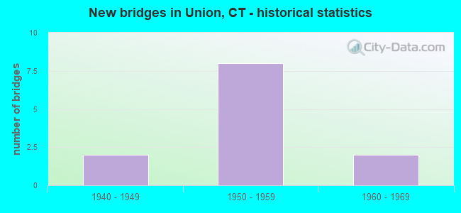
- New bridges - historical statistics
- 21940-1949
- 81950-1959
- 21960-1969

- Reconstructed bridges - Historical Statistics
- 11970-1979
- 11980-1989
- 01990-1999
- 12000-2009


- Bridge Condition - Deck
- 42.9%Good
- 14.3%Satisfactory
- 42.9%Fair

- Bridge Condition - Superstructure
- 12.5%Good
- 50.0%Satisfactory
- 37.5%Fair

- Bridge Condition - Substructure
- 25.0%Good
- 75.0%Satisfactory

- Bridge Condition - Channel
- 50.0%Good
- 25.0%Satisfactory
- 25.0%Fair
Find on map >> Show street view
Structure Number: 794, Location: 0.3 MI W OF US ROUTE 5 (Lat: 41.489394, Lng: -72.812367), Route carried "on" structure: State highway 15, Year Built: 1946, Status: Posted for load-capacity, Structure Length: 1.01m (3.31ft), Average Daily Traffic: 59,200 (year 2015), Truck Traffic: 5%, Average Future Daily Traffic: 87,965 (year 2035), Design Load: H 20, Features Intersected: ROUTE 68
Minimum Vertical Clearance: 30+ m (98+ ft), Kilometerpoint: 97.993, Lanes on structure: 4, Lanes under structure: 2, Base Highway Network: Yes, Owner: State Highway Agency, Approaching Roadway Width: 21.4m (70.2ft), Skew: 30 degrees, Material/Design: Concrete, Design/Construction: Frame, Number Of Spans In Main Unit: 1, Length of Maximum Span: 10.1m (33.1ft), Curb-To-Curb Width: 21.4m (70.2ft), Out-to-Out Width: 28.3m (92.8ft)
Condition: Superstructure: Satisfactory, Substructure: Satisfactory, Operating Rating: 89.8 metric tons, Method Used To Determine Operating Rating: Field evaluation and documented engineering judgment, Inventory Rating: 62.6 metric tons, Method Used To Determine Inventory Rating: Field evaluation and documented engineering judgment, Structural Evaluation: Equal to present minimum criteria, Deck Geometry: Better than present minimum criteria, Underclear: High priority of corrective action, Approach Roadway Alignment: Equal to present desirable criteria, Designated Inspection Frequency: Every 24 months, Inspection Date: September 2021, Wearing Surface/Protective System: Wearing Surface: Bituminous
Find on map >> Show street view
Structure Number: 848, Location: 0.57 MI SOUTH OF RTE 190 (Lat: 41.959156, Lng: -72.195464), Route carried "on" structure: State highway 89, Year Built: 1958, Status: Open, Structure Length: 6.00m (19.69ft), Average Daily Traffic: 900 (year 2020), Truck Traffic: 6%, Average Future Daily Traffic: 1,337 (year 2040), Design Load: HS 20, Features Intersected: INTERSTATE 84
Minimum Vertical Clearance: 30+ m (98+ ft), Kilometerpoint: 25.235, Lanes on structure: 2, Lanes under structure: 6, Owner: State Highway Agency, Approaching Roadway Width: 11.6m (38.1ft), Skew: 2 degrees, Material/Design: Steel continuous, Design/Construction: Stringer/Multi-beam, Number Of Spans In Main Unit: 2, Length of Maximum Span: 29.3m (96.1ft), Curb or Sidewalk Widths: Left: 0.5m (1.6ft), Right: 0.5m (1.6ft), Curb-To-Curb Width: 11.6m (38.1ft), Out-to-Out Width: 13.3m (43.6ft)
Condition: Deck: Fair, Superstructure: Fair, Substructure: Satisfactory, Operating Rating: 56.2 metric tons, Method Used To Determine Operating Rating: Load Factor (LF), Inventory Rating: 33.6 metric tons, Method Used To Determine Inventory Rating: Load Factor (LF), Structural Evaluation: Somewhat better than minimum adequacy, Deck Geometry: Better than present minimum criteria, Underclear: High priority of corrective action, Approach Roadway Alignment: Equal to present desirable criteria, Designated Inspection Frequency: Every 24 months, Inspection Date: October 2021, Deck Structure Type: Concrete Cast-file-Place, Wearing Surface/Protective System: Wearing Surface: Bituminous, Membrane: Preformed Fabric
Find on map >> Show street view
Structure Number: 849, Location: 1.2 MILES EAST OF RTE. 89 (Lat: 41.976089, Lng: -72.182514), Route carried "on" structure: State highway 190, Year Built: 1955, Year Reconstructed: 2014, Status: Open, Structure Length: 6.55m (21.49ft), Average Daily Traffic: 2,300 (year 2017), Truck Traffic: 6%, Average Future Daily Traffic: 3,418 (year 2037), Design Load: HL 93, Features Intersected: INTERSTATE-84
Minimum Vertical Clearance: 30+ m (98+ ft), Kilometerpoint: 42.294, Lanes on structure: 2, Lanes under structure: 6, Base Highway Network: Yes, Owner: State Highway Agency, Approaching Roadway Width: 12.2m (40.0ft), Skew: 3 degrees, Material/Design: Steel continuous, Design/Construction: Stringer/Multi-beam, Number Of Spans In Main Unit: 2, Length of Maximum Span: 31.7m (104.0ft), Curb-To-Curb Width: 12.2m (40.0ft), Out-to-Out Width: 13.3m (43.6ft)
Condition: Deck: Good, Superstructure: Satisfactory, Substructure: Good, Operating Rating: 87.1 metric tons, Method Used To Determine Operating Rating: Load Factor (LF), Inventory Rating: 52.2 metric tons, Method Used To Determine Inventory Rating: Load Factor (LF), Structural Evaluation: Equal to present minimum criteria, Deck Geometry: Equal to present minimum criteria, Underclear: Equal to present minimum criteria, Approach Roadway Alignment: Equal to present desirable criteria, Designated Inspection Frequency: Every 24 months, Inspection Date: October 2021, Deck Structure Type: Concrete Cast-file-Place, Wearing Surface/Protective System: Wearing Surface: Bituminous, Membrane: Built-up, Deck Protection: Epoxy Coated Reinforcing
Find on map >> Show street view
Structure Number: 85, Location: 0.5 MI FR MASS STATE LINE (Lat: 42.024975, Lng: -72.143100), Route carried "on" structure: State highway 171, Year Built: 1954, Year Reconstructed: 1986, Status: Open, Structure Length: 5.04m (16.54ft), Average Daily Traffic: 1,800 (year 2017), Truck Traffic: 6%, Average Future Daily Traffic: 2,675 (year 2037), Design Load: HS 20, Features Intersected: INTERSTATE-84
Minimum Vertical Clearance: 30+ m (98+ ft), Kilometerpoint: 0.563, Lanes on structure: 2, Lanes under structure: 6, Owner: State Highway Agency, Approaching Roadway Width: 9.7m (31.8ft), Material/Design: Steel, Design/Construction: Stringer/Multi-beam, Number Of Spans In Main Unit: 2, Length of Maximum Span: 24.4m (80.1ft), Curb-To-Curb Width: 9.7m (31.8ft), Out-to-Out Width: 10.9m (35.8ft)
Condition: Deck: Good, Superstructure: Fair, Substructure: Satisfactory, Operating Rating: 74.4 metric tons, Method Used To Determine Operating Rating: Load Factor (LF), Inventory Rating: 44.4 metric tons, Method Used To Determine Inventory Rating: Load Factor (LF), Structural Evaluation: Somewhat better than minimum adequacy, Deck Geometry: Somewhat better than minimum adequacy, Underclear: Meets minimum limits, Approach Roadway Alignment: Equal to present desirable criteria, Designated Inspection Frequency: Every 24 months, Inspection Date: June 2021, Deck Structure Type: Concrete Cast-file-Place, Wearing Surface/Protective System: Wearing Surface: Bituminous, Membrane: Preformed Fabric, Deck Protection: Epoxy Coated Reinforcing
Find on map >> Show street view
Structure Number: 851, Location: 0.2 MILE EAST OF RTE 171 (Lat: 42.026114, Lng: -72.141122), Route carried "on" structure: Interstate 84, Year Built: 1940, Year Reconstructed: 1975, Status: Open, Structure Length: 0.98m (3.22ft), Average Daily Traffic: 50,700 (year 2018), Truck Traffic: 16%, Average Future Daily Traffic: 75,335 (year 2038), Design Load: H 20, Features Intersected: MASHAPAUG POND
Minimum Vertical Clearance: 30+ m (98+ ft), Kilometerpoint: 156.927, Lanes on structure: 7, Base Highway Network: Yes, Owner: State Highway Agency, Approaching Roadway Width: 54.0m (177.2ft), Skew: 33 degrees, Material/Design: Concrete, Design/Construction: Slab, Number Of Spans In Main Unit: 1, Length of Maximum Span: 7.3m (24.0ft), Curb-To-Curb Width: 53.8m (176.5ft), Out-to-Out Width: 55.0m (180.4ft)
Condition: Deck: Fair, Superstructure: Satisfactory, Substructure: Satisfactory, Channel: Good, Operating Rating: 50.5 metric tons, Method Used To Determine Operating Rating: Load and Resistance Factor Rating (LRFR) rating reported by rating factor(RF) method using HL-93 loadings, Inventory Rating: 38.9 metric tons, Method Used To Determine Inventory Rating: Load and Resistance Factor Rating (LRFR) rating reported by rating factor(RF) method using HL-93 loadings, Structural Evaluation: Equal to present minimum criteria, Deck Geometry: Superior to present desirable criteria, Waterway Adequacy: Equal to present desirable criteria, Approach Roadway Alignment: Equal to present desirable criteria, Designated Inspection Frequency: Every 24 months, Underwater Inspection Frequency: Every 24 months, Inspection Date: June 2020, Underwater Inspection Date: June 2020, Deck Structure Type: Concrete Cast-file-Place, Wearing Surface/Protective System: Wearing Surface: Bituminous, Membrane: Built-up
Find on map >> Show street view
Structure Number: 1421, Location: .3 MILE WEST OF I-84 (Lat: 42.026361, Lng: -72.142017), Route carried "on" structure: State highway 171, Year Built: 1954, Status: Posted for load, Structure Length: 2.29m (7.51ft), Average Daily Traffic: 1,800 (year 2015), Truck Traffic: 2%, Average Future Daily Traffic: 2,675 (year 2035), Design Load: HS 20, Features Intersected: HAMILTON RESERVOIR BROOK
Minimum Vertical Clearance: 30+ m (98+ ft), Kilometerpoint: 0.354, Lanes on structure: 2, Owner: State Highway Agency, Approaching Roadway Width: 9.1m (29.9ft), Material/Design: Concrete continuous, Design/Construction: Slab, Number Of Spans In Main Unit: 3, Length of Maximum Span: 7.3m (24.0ft), Curb or Sidewalk Widths: Left: 0.9m (3.0ft), Right: 0.9m (3.0ft), Curb-To-Curb Width: 9.1m (29.9ft), Out-to-Out Width: 10.8m (35.4ft)
Condition: Deck: Good, Superstructure: Good, Substructure: Good, Channel: Satisfactory, Operating Rating: 51.6 metric tons, Method Used To Determine Operating Rating: Load Factor (LF), Inventory Rating: 31.0 metric tons, Method Used To Determine Inventory Rating: Load Factor (LF), Structural Evaluation: Better than present minimum criteria, Deck Geometry: Somewhat better than minimum adequacy, Waterway Adequacy: Equal to present desirable criteria, Approach Roadway Alignment: Equal to present desirable criteria, Designated Inspection Frequency: Every 24 months, Inspection Date: August 2020, Deck Structure Type: Concrete Cast-file-Place, Wearing Surface/Protective System: Wearing Surface: Bituminous
Find on map >> Show street view
Structure Number: 1744, Location: 0.7 MI E OF FARMINGTON TL (Lat: 41.732319, Lng: -72.752814), Route carried "on" structure: Interstate 84, Year Built: 1965, Status: Open, Structure Length: 4.60m (15.09ft), Average Daily Traffic: 68,000 (year 2018), Truck Traffic: 9%, Average Future Daily Traffic: 101,041 (year 2038), Design Load: HS 20, Features Intersected: BERKSHIRE ROAD
Minimum Vertical Clearance: 30+ m (98+ ft), Kilometerpoint: 91.169, Lanes on structure: 3, Lanes under structure: 2, Base Highway Network: Yes, Owner: State Highway Agency, Approaching Roadway Width: 11.4m (37.4ft), Skew: 5 degrees, Material/Design: Steel, Design/Construction: Stringer/Multi-beam, Number Of Spans In Main Unit: 3, Length of Maximum Span: 22.9m (75.1ft), Curb-To-Curb Width: 11.4m (37.4ft), Out-to-Out Width: 12.2m (40.0ft)
Condition: Deck: Satisfactory, Superstructure: Satisfactory, Substructure: Satisfactory, Operating Rating: 50.9 metric tons, Method Used To Determine Operating Rating: Load Factor (LF), Inventory Rating: 30.6 metric tons, Method Used To Determine Inventory Rating: Load Factor (LF), Structural Evaluation: Equal to present minimum criteria, Deck Geometry: High priority of replacement, Underclear: Somewhat better than minimum adequacy, Approach Roadway Alignment: Equal to present desirable criteria, Designated Inspection Frequency: Every 24 months, Inspection Date: December 2020, Total Project Cost: $4,300,000 ( Estimate for 2015), Deck Structure Type: Concrete Cast-file-Place, Wearing Surface/Protective System: Wearing Surface: Bituminous
Find on map >> Show street view
Structure Number: 1861, Location: 1500' NORTH OF ROUTE 171 (Lat: 42.026417, Lng: -72.139592), Route carried "on" structure: State highway 620, Year Built: 1953, Status: Open, Structure Length: 1.71m (5.61ft), Average Daily Traffic: 200 (year 2020), Truck Traffic: 3%, Average Future Daily Traffic: 297 (year 2040), Design Load: HS 20, Features Intersected: MASHAPAUG POND
Minimum Vertical Clearance: 30+ m (98+ ft), Kilometerpoint: 0.322, Lanes on structure: 2, Owner: State Highway Agency, Approaching Roadway Width: 9.1m (29.9ft), Material/Design: Concrete continuous, Design/Construction: Slab, Number Of Spans In Main Unit: 3, Length of Maximum Span: 4.9m (16.1ft), Curb or Sidewalk Widths: Left: 0.9m (3.0ft), Right: 0.9m (3.0ft), Curb-To-Curb Width: 9.1m (29.9ft), Out-to-Out Width: 10.9m (35.8ft)
Condition: Deck: Fair, Superstructure: Fair, Substructure: Satisfactory, Channel: Fair, Operating Rating: 50.8 metric tons, Method Used To Determine Operating Rating: Load Factor (LF), Inventory Rating: 30.5 metric tons, Method Used To Determine Inventory Rating: Load Factor (LF), Structural Evaluation: Somewhat better than minimum adequacy, Deck Geometry: Equal to present minimum criteria, Waterway Adequacy: Equal to present desirable criteria, Approach Roadway Alignment: Equal to present desirable criteria, Designated Inspection Frequency: Every 24 months, Inspection Date: November 2021, Deck Structure Type: Concrete Cast-file-Place, Wearing Surface/Protective System: Wearing Surface: Bituminous, Membrane: Preformed Fabric
Find on map >> Show street view
Structure Number: 3286, Location: ROUTE 9 NB EXIT 9 ON RAMP (Lat: 41.473822, Lng: -72.556853), Route carried "on" structure: Ramp State highway 9, Year Built: 1965, Status: Open, Structure Length: 0.98m (3.22ft), Average Daily Traffic: 3,550 (year 2021), Truck Traffic: 6%, Average Future Daily Traffic: 5,275 (year 2041), Design Load: HS 20, Features Intersected: PONSET BROOK
Minimum Vertical Clearance: 30+ m (98+ ft), Kilometerpoint: 0.257, Lanes on structure: 2, Owner: State Highway Agency, Approaching Roadway Width: 16.5m (54.1ft), Skew: 24 degrees, Material/Design: Concrete continuous, Design/Construction: Culvert, Number Of Spans In Main Unit: 2, Length of Maximum Span: 4.6m (15.1ft)
Condition: Channel: Good, Culverts: Satisfactory, Structural Evaluation: Equal to present minimum criteria, Waterway Adequacy: Equal to present minimum criteria, Approach Roadway Alignment: Equal to present desirable criteria, Designated Inspection Frequency: Every 24 months, Inspection Date: July 2021
Find on map >> Show street view
Structure Number: 848, Location: 0.57 MI SOUTH OF RTE 190 (Lat: 41.959156, Lng: -72.195464), Route carried "under" structure: Interstate 84, Year Built: 1958, Structure Length: 0. m, Average Daily Traffic: 51,600 (year 2018), Truck Traffic: 16%, Features Intersected: INTERSTATE 84, Facility Carried by Structure: ROUTE 89
Minimum Vertical Clearance: 4.90m (16.08ft), Kilometerpoint: 148.140, Lanes on structure: 2, Lanes under structure: 6, Material/Design: Steel continuous, Design/Construction: Stringer/Multi-beam, Length of Maximum Span: 29.3m (96.1ft)
Find on map >> Show street view
Structure Number: 849, Location: 1.2 MILES EAST OF RTE. 89 (Lat: 41.976089, Lng: -72.182514), Route carried "under" structure: Interstate 84, Year Built: 1955, Structure Length: 0. m, Average Daily Traffic: 50,200 (year 2018), Truck Traffic: 16%, Features Intersected: INTERSTATE-84, Facility Carried by Structure: ROUTE 190
Minimum Vertical Clearance: 5.31m (17.42ft), Kilometerpoint: 150.329, Lanes on structure: 2, Lanes under structure: 6, Material/Design: Steel continuous, Design/Construction: Stringer/Multi-beam, Length of Maximum Span: 31.7m (104.0ft)
Find on map >> Show street view
Structure Number: 85, Location: 0.5 MI FR MASS STATE LINE (Lat: 42.024975, Lng: -72.143100), Route carried "under" structure: Interstate 84, Year Built: 1954, Structure Length: 0. m, Average Daily Traffic: 50,700 (year 2018), Truck Traffic: 16%, Features Intersected: INTERSTATE-84, Facility Carried by Structure: ROUTE 171
Minimum Vertical Clearance: 4.65m (15.26ft), Kilometerpoint: 156.718, Lanes on structure: 2, Lanes under structure: 6, Material/Design: Steel, Design/Construction: Stringer/Multi-beam, Length of Maximum Span: 24.4m (80.1ft)