Union, Connecticut

Submit your own pictures of this town and show them to the world
- OSM Map
- General Map
- Google Map
- MSN Map
Population change since 2000: +23.2%
| Males: 427 | |
| Females: 427 |
| Median resident age: | 46.5 years |
| Connecticut median age: | 39.2 years |
Zip codes: 06076.
| Union: | $95,445 |
| CT: | $88,429 |
Estimated per capita income in 2022: $50,028 (it was $27,900 in 2000)
Union town income, earnings, and wages data
Estimated median house or condo value in 2022: $331,851 (it was $153,500 in 2000)
| Union: | $331,851 |
| CT: | $347,200 |
Mean prices in 2022: all housing units: $356,092; detached houses: $368,662; townhouses or other attached units: $222,514; in 2-unit structures: $281,599; in 3-to-4-unit structures: $156,197; in 5-or-more-unit structures: $146,539; mobile homes: $46,042
Detailed information about poverty and poor residents in Union, CT
Compare current foreclosures near Union, CT:
| Photo | Address | Area | Beds / Baths | Price | Details |
|---|---|---|---|---|---|

|
#1
Tolland Ave
Stafford Springs, CT 06076
|
896 sq. feet
|
1 baths 3 beds |
$100,000
|
show details |

|
#2
Kozley Rd
Tolland, CT 06084
|
1,132 sq. feet
|
2 baths 3 beds |
$264,900
|
show details |

|
#3
Clarence Dr
Oxford, MA 01540
|
3,010 sq. feet
|
3 baths 5 beds |
$569,900
|
show details |

|
#4
Old West Brookfield Road
Warren, MA 01083
|
1,760 sq. feet
|
2 baths 4 beds |
show details | |

|
#5
Woodland Dr
Hampden, MA 01036
|
972 sq. feet
|
1 baths 3 beds |
show details | |

|
#6
Pine St
Dudley, MA 01571
|
1,414 sq. feet
|
2 baths 4 beds |
show details | |

|
#7
Wales Rd
Brimfield, MA 01010
|
2,312 sq. feet
|
2 baths 3 beds |
show details | |

|
#8
Paine District Rd
Woodstock, CT 06281
|
1,092 sq. feet
|
1 baths 2 beds |
show details | |

|
#9
Marc Ave
Southbridge, MA 01550
|
960 sq. feet
|
1 baths 3 beds |
show details | |

|
#10
Reed St
Warren, MA 01083
|
1,152 sq. feet
|
2 baths 3 beds |
show details |
| Photo | Address | Area | Beds / Baths | Price | Details |
|---|---|---|---|---|---|

|
#11
Dennis Ln
Stafford Springs, CT 06076
|
1,171 sq. feet
|
2 baths 3 beds |
show details | |

|
#12
Dillenback Rd
Somers, CT 06071
|
3,358 sq. feet
|
3 baths 4 beds |
show details | |

|
#13
East Road
Warren, MA 01083
|
1,938 sq. feet
|
2 baths 3 beds |
show details | |

|
#14
Nelson Street
Warren, MA 01083
|
- sq. feet
|
2 baths 3 beds |
show details | |

|
#15
Stafford Rd
Monson, MA 01057
|
1,464 sq. feet
|
1 baths 3 beds |
show details | |

|
#16
Elm St
Webster, MA 01570
|
1,197 sq. feet
|
1 baths 3 beds |
show details | |

|
#17
Hovey Rd
Monson, MA 01057
|
2,256 sq. feet
|
1 baths 4 beds |
show details | |

|
#18
Brookfield Rd
Brimfield, MA 01010
|
1,482 sq. feet
|
3 baths 3 beds |
show details | |

|
#19
Willimantic Rd
Chaplin, CT 06235
|
2,332 sq. feet
|
3 baths 5 beds |
show details | |

|
#20
Longview St
Palmer, MA 01069
|
2,474 sq. feet
|
3 baths 3 beds |
show details |
| Photo | Address | Area | Beds / Baths | Price | Details |
|---|---|---|---|---|---|

|
#21
Flynt St
Palmer, MA 01069
|
1,200 sq. feet
|
1 baths 3 beds |
show details | |

|
#22
Atwoodville Ln
Mansfield Center, CT 06250
|
2,256 sq. feet
|
3 baths 2 beds |
show details | |

|
#23
Perryville Rd
Webster, MA 01570
|
1,424 sq. feet
|
2 baths 3 beds |
show details | |

|
#24
Shenipsit Lake Rd
Tolland, CT 06084
|
1,623 sq. feet
|
1 baths 3 beds |
show details | |

|
#25
Highcrest Park
Webster, MA 01570
|
1,536 sq. feet
|
2 baths 2 beds |
show details | |

|
#26
School St
Webster, MA 01570
|
3,066 sq. feet
|
4 baths 6 beds |
show details | |

|
#27
Partridge Ln
Tolland, CT 06084
|
1,221 sq. feet
|
2 baths 4 beds |
show details | |

|
#28
Pine St
Dudley, MA 01571
|
1,118 sq. feet
|
1 baths 2 beds |
show details | |

|
#29
Groveland Ave
Putnam, CT 06260
|
960 sq. feet
|
1 baths 3 beds |
show details | |

|
#30
Park Rd
Charlton, MA 01507
|
640 sq. feet
|
1 baths 2 beds |
show details |
| Photo | Address | Area | Beds / Baths | Price | Details |
|---|---|---|---|---|---|

|
#31
Warsaw Ave
Dudley, MA 01571
|
1,484 sq. feet
|
2 baths 3 beds |
show details | |

|
#32
Lakeview Dr
Charlton, MA 01507
|
1,235 sq. feet
|
1 baths 2 beds |
show details | |

|
#33
Webster Rd
Ellington, CT 06029
|
2,744 sq. feet
|
2 baths 3 beds |
show details | |

|
#34
Alton Dr
Dudley, MA 01571
|
1,608 sq. feet
|
1 baths 4 beds |
show details | |

|
#35
Baxter St
Tolland, CT 06084
|
4,242 sq. feet
|
4 baths 3 beds |
show details | |

|
#36
Alton Dr
Dudley, MA 01571
|
1,368 sq. feet
|
1 baths 4 beds |
show details | |

|
#37
Wicker St
Putnam, CT 06260
|
1,144 sq. feet
|
1 baths 3 beds |
show details | |

|
#38
Norma St
Palmer, MA 01069
|
1,144 sq. feet
|
1 baths 3 beds |
show details | |

|
#39
Union Rd
Wales, MA 01081
|
3,616 sq. feet
|
2 baths 4 beds |
show details | |

|
#40
Fox St
Palmer, MA 01069
|
1,924 sq. feet
|
2 baths 3 beds |
show details |
| Photo | Address | Area | Beds / Baths | Price | Details |
|---|---|---|---|---|---|

|
#41
Vandale St
Putnam, CT 06260
|
1,671 sq. feet
|
3 baths 3 beds |
show details | |

|
#42
Buckley Hill Rd
North Grosvenordale, CT 06255
|
2,040 sq. feet
|
2 baths 4 beds |
show details | |

|
#43
Brooklyn Rd
Pomfret Center, CT 06259
|
1,951 sq. feet
|
1 baths 4 beds |
show details | |

|
#44
Catherine St
Dudley, MA 01571
|
1,248 sq. feet
|
1 baths 4 beds |
show details | |

|
#45
Delaney Ave
Dudley, MA 01571
|
1,226 sq. feet
|
1 baths 2 beds |
show details | |

|
#46
Jericho Rd
Pomfret Center, CT 06259
|
1,154 sq. feet
|
1 baths 1 beds |
show details | |

|
#47
Muggett Hill Rd
Charlton, MA 01507
|
2,728 sq. feet
|
2 baths 3 beds |
show details | |

|
#48
La Cabana Rd
Somers, CT 06071
|
2,629 sq. feet
|
2 baths 5 beds |
show details | |

|
#49
Johnathan Pass
Dudley, MA 01571
|
2,570 sq. feet
|
2 baths 3 beds |
show details | |

|
Check over 1 million property listings on Foreclosure.com!
|
browse all offers | |||

- 79092.5%White alone
- 323.7%Hispanic
- 222.6%Two or more races
- 40.5%Asian alone
- 30.4%Black alone
- 30.4%American Indian alone
Races in Union detailed stats: ancestries, foreign born residents, place of birth
According to our research of Connecticut and other state lists, there were 2 registered sex offenders living in Union, Connecticut as of May 21, 2024.
The ratio of all residents to sex offenders in Union is 427 to 1.
 Recent articles from our blog. Our writers, many of them Ph.D. graduates or candidates, create easy-to-read articles on a wide variety of topics.


 | Best Federal Credit Union in Connecticut (or even West Massachusetts)? (9 replies) |
| Connecticut's Republican Party - Will it change with the times? (1046 replies) |
| Any restaurants near New Haven Union station? (18 replies) |
| Connecticut TOWN TOURNAMENT V (2022) (831 replies) |
| Connecticut TOWN TOURNAMENT IV (2020) (849 replies) |
| Quinnipiac University ?s - Bridgeport ferry (17 replies) |
Latest news from Union, CT collected exclusively by city-data.com from local newspapers, TV, and radio stations
Union, CT City Guides:
Ancestries: English (16.5%), Irish (15.2%), French (14.7%), German (13.4%), Polish (12.7%), Italian (9.2%).
Current Local Time: EST time zone
Incorporated on 10/1734
Elevation: 975 feet
Land area: 28.7 square miles.
Population density: 30 people per square mile (very low).
21 residents are foreign born (1.7% Europe, 0.7% Asia, 0.6% Latin America).
| This town: | 3.0% |
| Connecticut: | 10.9% |
| Union town: | 1.4% ($2,167) |
| Connecticut: | 1.8% ($2,961) |
Nearest city with pop. 50,000+: Springfield, MA  (21.3 miles , pop. 152,082).
Nearest city with pop. 200,000+: Boston, MA (59.6 miles , pop. 589,141).
Nearest city with pop. 1,000,000+: Bronx, NY (119.0 miles , pop. 1,332,650).
Nearest cities:
), ), ), Latitude: 41.99 N, Longitude: 72.16 W
Area code commonly used in this area: 860

Single-family new house construction building permits:
- 2022: 1 building, cost: $170,000
- 2021: 2 buildings, average cost: $218,500
- 2020: 2 buildings, average cost: $137,400
- 2019: 6 buildings, average cost: $146,000
- 2018: 2 buildings, average cost: $144,800
- 2017: 3 buildings, average cost: $147,000
- 2015: 1 building, cost: $118,000
- 2014: 1 building, cost: $84,000
- 2013: 1 building, cost: $154,000
- 2012: 1 building, cost: $242,000
- 2011: 3 buildings, average cost: $189,300
- 2009: 3 buildings, average cost: $304,000
- 2008: 3 buildings, average cost: $233,800
- 2007: 2 buildings, average cost: $422,000
- 2006: 5 buildings, average cost: $218,800
- 2005: 8 buildings, average cost: $225,500
- 2004: 3 buildings, average cost: $165,700
- 2003: 6 buildings, average cost: $173,800
- 2002: 6 buildings, average cost: $144,000
- 2001: 6 buildings, average cost: $212,200
- 2000: 5 buildings, average cost: $169,400
- 1999: 4 buildings, average cost: $147,300
- 1998: 8 buildings, average cost: $114,100
- 1997: 7 buildings, average cost: $127,000
| Here: | 3.7% |
| Connecticut: | 3.9% |
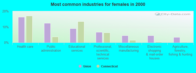
- Construction (14.7%)
- Public administration (11.6%)
- Health care (9.9%)
- Educational services (7.2%)
- Professional, scientific, technical services (6.3%)
- Finance & insurance (3.9%)
- Miscellaneous manufacturing (3.6%)
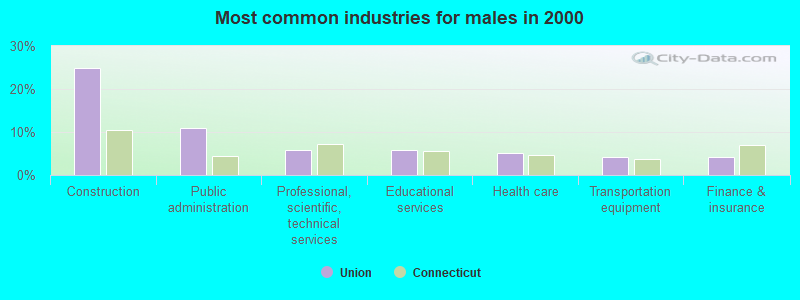
- Construction (25.0%)
- Public administration (11.0%)
- Professional, scientific, technical services (5.9%)
- Educational services (5.9%)
- Health care (5.1%)
- Transportation equipment (4.2%)
- Finance & insurance (4.2%)
- Health care (16.3%)
- Public administration (12.4%)
- Educational services (9.0%)
- Professional, scientific, technical services (6.7%)
- Miscellaneous manufacturing (4.5%)
- Electronic shopping & mail-order houses (4.5%)
- Agriculture, forestry, fishing & hunting (3.4%)
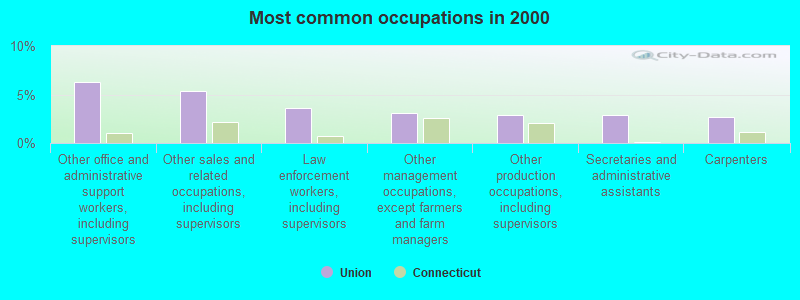
- Other office and administrative support workers, including supervisors (6.3%)
- Other sales and related occupations, including supervisors (5.3%)
- Law enforcement workers, including supervisors (3.6%)
- Other management occupations, except farmers and farm managers (3.1%)
- Other production occupations, including supervisors (2.9%)
- Secretaries and administrative assistants (2.9%)
- Carpenters (2.7%)
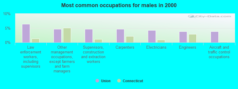
- Law enforcement workers, including supervisors (6.4%)
- Other management occupations, except farmers and farm managers (4.7%)
- Supervisors, construction and extraction workers (4.7%)
- Carpenters (4.7%)
- Electricians (4.2%)
- Engineers (3.8%)
- Aircraft and traffic control occupations (3.8%)
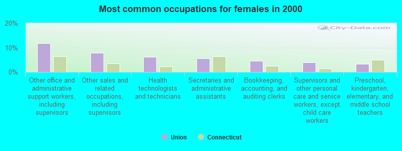
- Other office and administrative support workers, including supervisors (11.8%)
- Other sales and related occupations, including supervisors (7.9%)
- Health technologists and technicians (6.2%)
- Secretaries and administrative assistants (5.6%)
- Bookkeeping, accounting, and auditing clerks (4.5%)
- Supervisors and other personal care and service workers, except child care workers (3.9%)
- Preschool, kindergarten, elementary, and middle school teachers (3.4%)
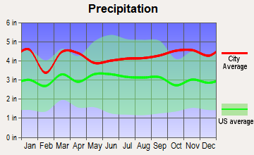
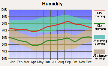
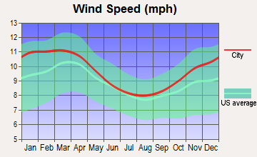
Average climate in Union, Connecticut
Based on data reported by over 4,000 weather stations

(lower is better)
Air Quality Index (AQI) level in 2023 was 98.8. This is worse than average.
| City: | 98.8 |
| U.S.: | 72.6 |
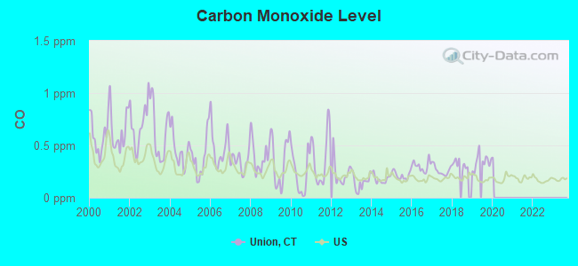
Carbon Monoxide (CO) [ppm] level in 2019 was 0.346. This is worse than average. Closest monitor was 19.7 miles away from the city center.
| City: | 0.346 |
| U.S.: | 0.251 |
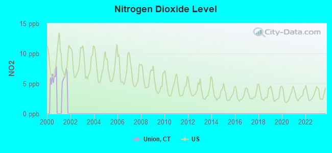
Nitrogen Dioxide (NO2) [ppb] level in 2000 was 6.13. This is worse than average. Closest monitor was 11.6 miles away from the city center.
| City: | 6.13 |
| U.S.: | 5.11 |
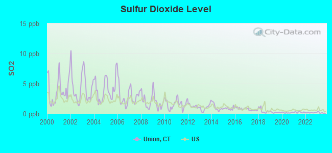
Sulfur Dioxide (SO2) [ppb] level in 2022 was 0.180. This is significantly better than average. Closest monitor was 12.8 miles away from the city center.
| City: | 0.180 |
| U.S.: | 1.515 |
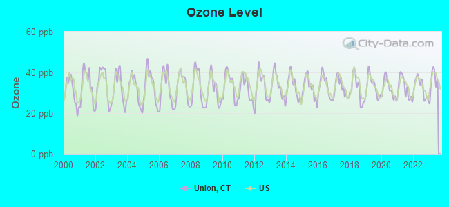
Ozone [ppb] level in 2023 was 35.8. This is about average. Closest monitor was 11.4 miles away from the city center.
| City: | 35.8 |
| U.S.: | 33.3 |
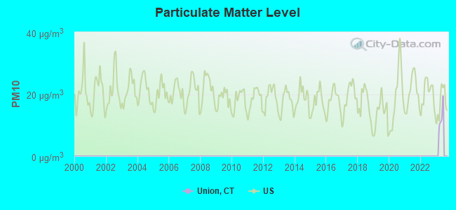
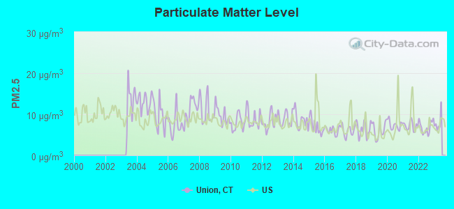
Particulate Matter (PM2.5) [µg/m3] level in 2022 was 6.82. This is about average. Closest monitor was 22.8 miles away from the city center.
| City: | 6.82 |
| U.S.: | 8.11 |
Tornado activity:
Union-area historical tornado activity is slightly above Connecticut state average. It is 18% smaller than the overall U.S. average.
On 10/3/1979, a category F4 (max. wind speeds 207-260 mph) tornado 27.2 miles away from the Union town center killed 3 people and injured 500 people and caused between $50,000,000 and $500,000,000 in damages.
On 6/9/1953, a category F4 tornado 32.9 miles away from the town center killed 90 people and injured 1228 people and caused between $50,000,000 and $500,000,000 in damages.
Earthquake activity:
Union-area historical earthquake activity is significantly above Connecticut state average. It is 71% smaller than the overall U.S. average.On 10/7/1983 at 10:18:46, a magnitude 5.3 (5.1 MB, 5.3 LG, 5.1 ML, Class: Moderate, Intensity: VI - VII) earthquake occurred 174.6 miles away from Union center
On 4/20/2002 at 10:50:47, a magnitude 5.3 (5.3 ML, Depth: 3.0 mi) earthquake occurred 190.5 miles away from Union center
On 4/20/2002 at 10:50:47, a magnitude 5.2 (5.2 MB, 4.2 MS, 5.2 MW, 5.0 MW) earthquake occurred 189.4 miles away from Union center
On 1/19/1982 at 00:14:42, a magnitude 4.7 (4.5 MB, 4.7 MD, 4.5 LG, Class: Light, Intensity: IV - V) earthquake occurred 108.0 miles away from Union center
On 10/16/2012 at 23:12:25, a magnitude 4.7 (4.7 ML, Depth: 10.0 mi) earthquake occurred 134.8 miles away from Union center
On 8/22/1992 at 12:20:32, a magnitude 4.8 (4.8 MB, 3.8 MS, 4.7 LG, Depth: 6.2 mi) earthquake occurred 222.0 miles away from the city center
Magnitude types: regional Lg-wave magnitude (LG), body-wave magnitude (MB), duration magnitude (MD), local magnitude (ML), surface-wave magnitude (MS), moment magnitude (MW)
Natural disasters:
The number of natural disasters in Tolland County (24) is greater than the US average (15).Major Disasters (Presidential) Declared: 13
Emergencies Declared: 11
Causes of natural disasters: Hurricanes: 6, Snowstorms: 5, Storms: 5, Blizzards: 3, Floods: 3, Snows: 3, Winter Storms: 3, Snowfall: 1, Tropical Storm: 1, Wind: 1, Other: 1 (Note: some incidents may be assigned to more than one category).

Hospitals and medical centers near Union:
- HARRINGTON MEMORIAL HOSPITAL Acute Care Hospitals (about 9 miles away; SOUTHBRIDGE, MA)
- LIBERTY HOUSE (Nursing Home, about 9 miles away; SOUTHBRIDGE, MA)
- PROVIDENCE HOUSE N H OF SOUTHBRIDGE (Nursing Home, about 9 miles away; SOUTHBRIDGE, MA)
- RADIUS HEALTHCARE-SOUTHBRIDGE (Nursing Home, about 9 miles away; SOUTHBRIDGE, MA)
- JOHNSON MEMORIAL HOSPITAL Acute Care Hospitals (about 12 miles away; STAFFORD SPRINGS, CT)
- EVERGREEN HEALTH CARE CENTER (Nursing Home, about 12 miles away; STAFFORD SPRINGS, CT)
- T R I-COUNTY ARC: DUNN HILL (Hospital, about 14 miles away; TOLLAND, CT)
Colleges/universities with over 2000 students nearest to Union:
- University of Connecticut (about 14 miles; Storrs, CT; Full-time enrollment: 22,037)
- Eastern Connecticut State University (about 20 miles; Willimantic, CT; FT enrollment: 4,985)
- Western New England University (about 21 miles; Springfield, MA; FT enrollment: 3,477)
- Springfield College (about 22 miles; Springfield, MA; FT enrollment: 3,144)
- American International College (about 22 miles; Springfield, MA; FT enrollment: 2,733)
- Bay Path College (about 22 miles; Longmeadow, MA; FT enrollment: 2,085)
- Springfield Technical Community College (about 23 miles; Springfield, MA; FT enrollment: 4,750)
Public high school in Union:
Public elementary/middle schools in Union:
- WEST DISTRICT SCHOOL (Students: 425, Location: 114 WEST DISTRICT ROAD, Grades: KG-4)
- UNION SCHOOL (Students: 74, Location: 173 SCHOOL STREET, Grades: KG-4)
Points of interest:
Notable location: Union Volunteer Fire Department (A). Display/hide its location on the map
Cemetery: Rindge Cemetery (1). Display/hide its location on the map
Lakes and reservoirs: Wells Pond (A), Willis Pond (B), Harmon Pond (C), Lost Pond (D), Moore Pond (E), Morse Meadow Pond (F), Myers Pond (G), Breakneck Pond (H). Display/hide their locations on the map
Streams, rivers, and creeks: Scranton Brook (A), Leadmine Brook (B), Bush Meadow Brook (C), Wells Brook (D), Gulf Brook (E), Stickney Hill Brook (F). Display/hide their locations on the map
Parks in Union include: Bigelow Hollow State Park (1), Bigelow State Park (2). Display/hide their locations on the map
Birthplace of: Alonzo Horton - San Diego developer, Bernie Digris - Football player, Tom Tuckey - Baseball player.
| This town: | 2.6 people |
| Connecticut: | 2.5 people |
| This town: | 75.7% |
| Whole state: | 66.3% |
| This town: | 7.8% |
| Whole state: | 6.6% |
Likely homosexual households (counted as self-reported same-sex unmarried-partner households)
- Lesbian couples: 0.9% of all households
- Gay men: 0.6% of all households
| This town: | 3.5% |
| Whole state: | 7.9% |
| This town: | 1.2% |
| Whole state: | 3.9% |
For population 15 years and over in Union:
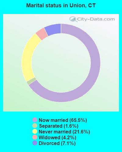
- Never married: 21.6%
- Now married: 65.5%
- Separated: 1.6%
- Widowed: 4.2%
- Divorced: 7.1%
For population 25 years and over in Union:
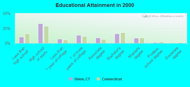
- High school or higher: 89.3%
- Bachelor's degree or higher: 26.4%
- Graduate or professional degree: 10.5%
- Unemployed: 2.1%
- Mean travel time to work (commute): 31.4 minutes
| Here: | 9.9 |
| Connecticut average: | 12.8 |
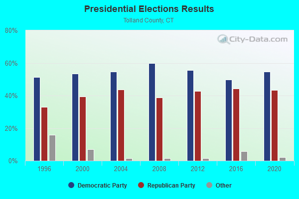
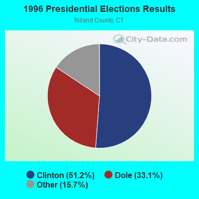
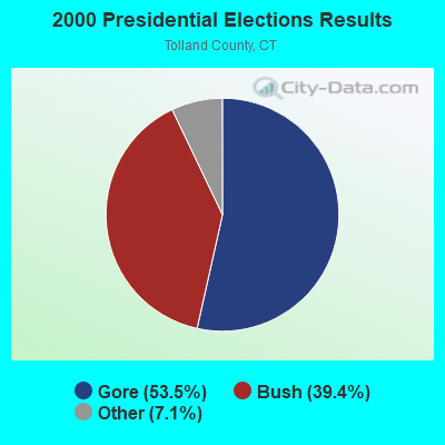
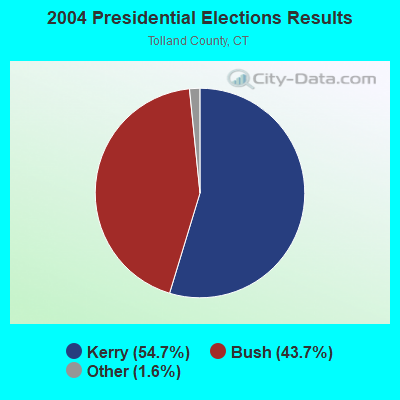
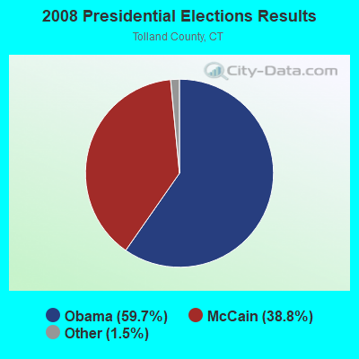
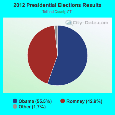
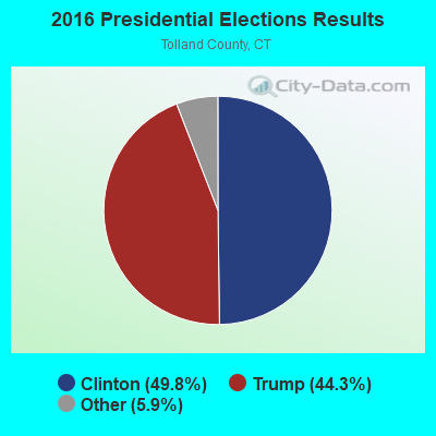
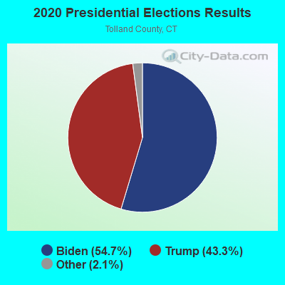
Graphs represent county-level data. Detailed 2008 Election Results
Religion statistics for Union, CT (based on Tolland County data)
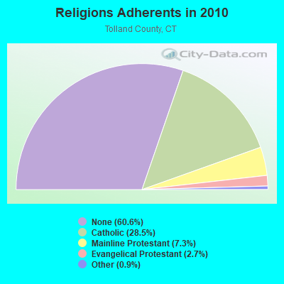
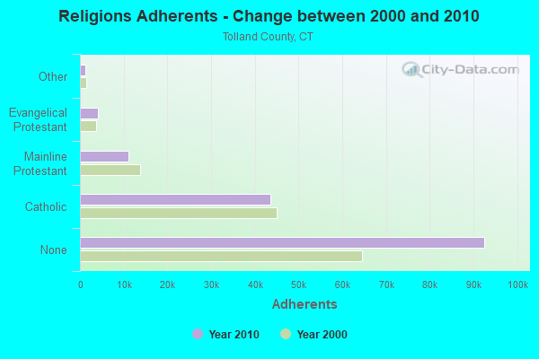
| Religion | Adherents | Congregations |
|---|---|---|
| Catholic | 43,500 | 14 |
| Mainline Protestant | 11,178 | 38 |
| Evangelical Protestant | 4,069 | 27 |
| Other | 1,302 | 8 |
| Orthodox | 100 | 1 |
| None | 92,542 | - |
Food Environment Statistics:
| Here: | 1.36 / 10,000 pop. |
| Connecticut: | 2.21 / 10,000 pop. |
| This county: | 1.15 / 10,000 pop. |
| Connecticut: | 1.02 / 10,000 pop. |
| Tolland County: | 2.24 / 10,000 pop. |
| Connecticut: | 2.27 / 10,000 pop. |
| Tolland County: | 6.57 / 10,000 pop. |
| Connecticut: | 9.19 / 10,000 pop. |
| This county: | 6.2% |
| Connecticut: | 7.3% |
| Tolland County: | 21.1% |
| Connecticut: | 21.5% |
| Tolland County: | 12.9% |
| Connecticut: | 15.8% |
Strongest AM radio stations in Union:
- WCRN (830 AM; 50 kW; WORCESTER, MA; Owner: CARTER BROADCASTING CORPORATION)
- WVNE (760 AM; daytime; 25 kW; LEICESTER, MA; Owner: BLOUNT MASSCOM, INC.)
- WNNZ (640 AM; 50 kW; WESTFIELD, MA; Owner: CLEAR CHANNEL BROADCASTING LICENSES, INC.)
- WALE (990 AM; 50 kW; GREENVILLE, RI; Owner: NORTH AMERICAN BROADCASTING CO., INC.)
- WTIC (1080 AM; 50 kW; HARTFORD, CT; Owner: INFINITY RADIO OPERATIONS INC.)
- WKOX (1200 AM; 50 kW; FRAMINGHAM, MA; Owner: CAPSTAR TX LIMITED PARTNERSHIP)
- WEEI (850 AM; 50 kW; BOSTON, MA; Owner: ENTERCOM BOSTON LICENSE, LLC)
- WBIX (1060 AM; 40 kW; NATICK, MA; Owner: LANGER BROADCASTING CORPORATION)
- WRKO (680 AM; 50 kW; BOSTON, MA; Owner: ENTERCOM BOSTON LICENSE, LLC)
- WINY (1350 AM; 5 kW; PUTNAM, CT; Owner: OSBREY BROADCASTING COMPANY)
- WAMG (890 AM; 25 kW; DEDHAM, MA; Owner: MEGA COMMUNICATIONS OF DEDHAM LICENSEE, LLC)
- WARE (1250 AM; 5 kW; WARE, MA; Owner: SUCCESS SIGNAL BROADCASTING, INC.)
- WWZN (1510 AM; 50 kW; BOSTON, MA; Owner: ROSE CITY RADIO CORPORATION)
Strongest FM radio stations in Union:
- WWFX (100.1 FM; SOUTHBRIDGE, MA; Owner: CITADEL BROADCASTING COMPANY)
- WORC-FM (98.9 FM; WEBSTER, MA; Owner: CITADEL BROADCASTING COMPANY)
- WHUS (91.7 FM; STORRS, CT; Owner: THE BD. OF TRUSTEES, THE UNIV. OF CT)
- WAAF (107.3 FM; WORCESTER, MA; Owner: ENTERCOM BOSTON LICENSE, LLC)
- WSRS (96.1 FM; WORCESTER, MA; Owner: CAPSTAR TX LIMITED PARTNERSHIP)
- W258AC (99.5 FM; STORRS, CT; Owner: CONNECTICUT PUBLIC BROADCASTING, INC)
- WYCM (90.1 FM; CHARLTON, MA; Owner: BAY PATH VOCATIONAL HIGH SCHOOL)
- WFCR (88.5 FM; AMHERST, MA; Owner: UNIVERSITY OF MASSACHUSETTS)
- WHYN-FM (93.1 FM; SPRINGFIELD, MA; Owner: CLEAR CHANNEL BROADCASTING LICENSES, INC.)
- WRNX (100.9 FM; AMHERST, MA; Owner: WESTERN MASSACHUSETTS RADIO COMPANY)
- WBVC (91.1 FM; POMFRET, CT; Owner: POMFRET SCHOOL)
- WRCH (100.5 FM; NEW BRITAIN, CT; Owner: INFINITY RADIO OPERATIONS INC.)
- WAQY (102.1 FM; SPRINGFIELD, MA; Owner: SAGA COMMUNICATIONS OF NEW ENGLAND, LLC)
- WILI-FM (98.3 FM; WILLIMANTIC, CT; Owner: NUTMEG BROADCASTING COMPANY)
- WAMH (89.3 FM; AMHERST, MA; Owner: TRUSTEES OF AMHERST COLLEGE)
- WTIC-FM (96.5 FM; HARTFORD, CT; Owner: INFINITY RADIO OPERATIONS INC.)
- WWUH (91.3 FM; WEST HARTFORD, CT; Owner: UNIVERSITY OF HARTFORD)
- W246AM (97.1 FM; AMHERST, MA; Owner: GREAT NORTHERN RADIO, LLC)
- WECS (90.1 FM; WILLIMANTIC, CT; Owner: EASTERN CONNECTICUT STATE COLLEGE)
- WCCC-FM (106.9 FM; HARTFORD, CT; Owner: MARLIN BROADCASTING, LLC)
TV broadcast stations around Union:
- WYDN (Channel 48; WORCESTER, MA; Owner: EDUCATIONAL PUBLIC TV CORPORATION)
- WTIC-TV (Channel 61; HARTFORD, CT; Owner: TRIBUNE TELEVISION COMPANY)
- W11BJ (Channel 11; HARTFORD, CT; Owner: COMMUNICATIONS SITE MANAGEMENT LLC)
- WUNI (Channel 27; WORCESTER, MA; Owner: ENTRAVISION HOLDINGS, LLC)
- WPXQ (Channel 69; BLOCK ISLAND, RI; Owner: OCEAN STATE TELEVISION, L.L.C.)
- WTXX (Channel 20; WATERBURY, CT; Owner: WTXX INC.)
- WUVN (Channel 18; HARTFORD, CT; Owner: ENTRAVISION HOLDINGS, LLC)
- WHPX (Channel 26; NEW LONDON, CT; Owner: PAXSON HARTFORD LICENSE, INC.)
- WVIT (Channel 30; NEW BRITAIN, CT; Owner: OUTLET BROADCASTING, INC)
- WUTF (Channel 66; MARLBOROUGH, MA; Owner: TELEFUTURA BOSTON LLC)
- WEDH (Channel 24; HARTFORD, CT; Owner: CONNECTICUT PUBLIC BROADCASTING, INC.)
- WWLP (Channel 22; SPRINGFIELD, MA; Owner: WWLP BROADCASTING, LLC)
- WCRN-LP (Channel 34; LEICESTER, MA; Owner: CARTER BROADCASTING CORPORATION)
- Union, Connecticut
- Fatal accident count26
- Vehicles involved in fatal accidents36
- Fatal accidents involving drunk persons:7
- Fatalities30
- Persons involved in fatal accidents65
- Pedestrians involved in fatal accidents0
- Connecticut average
- Fatal accident count6644
- Vehicles involved in fatal accidents9802
- Fatal accidents involving drunk persons2810
- Fatalities7152
- Persons involved in fatal accidents15576
- Pedestrians involved in fatal accidents731
- National Bridge Inventory (NBI) Statistics
- 12Number of bridges
- 95ft / 29.2mTotal length
- $4,300,000Total costs
- 340,950Total average daily traffic
- 42,147Total average daily truck traffic
- New bridges - historical statistics
- 21940-1949
- 81950-1959
- 21960-1969
FCC Registered Cell Phone Towers:
2- 107 Stickney Hill Road (59354) (Lat: 41.985389 Lon: -72.192167), Type: Ltower, Structure height: 34.1 m, Overall height: 37.5 m, Call Sign: KNKA239
Assigned Frequencies: 880.020 MHz, 880.020 MHz, 880.020 MHz, 835.020 MHz, 835.020 MHz, 835.020 MHz, 891.510 MHz, 891.510 MHz, 891.510 MHz, 846.510 MHz, 846.510 MHz, 846.510 MHzGrant Date: 09/03/2014, Expiration Date: 10/01/2024, Certifier: David C JatlowRegistrant: At&t Services, Inc., 208 S Akard St, 20f, Dallas, TX 75202, Phone: (855) 699-7073, Fax: (214) 746-6410, Email:
- 1050 Buckley Hwy (26020) (Lat: 41.999167 Lon: -72.152361), Type: Ltower, Structure height: 51.8 m, Overall height: 57 m, Call Sign: KNKA239
Assigned Frequencies: 880.020 MHz, 880.020 MHz, 880.020 MHz, 835.020 MHz, 835.020 MHz, 835.020 MHz, 891.510 MHz, 891.510 MHz, 891.510 MHz, 846.510 MHz, 846.510 MHz, 846.510 MHzGrant Date: 09/03/2014, Expiration Date: 10/01/2024, Certifier: David C JatlowRegistrant: At&t Services, Inc., 208 S Akard St, 20f, Dallas, TX 75202, Phone: (855) 699-7073, Fax: (214) 746-6410, Email:
FCC Registered Antenna Towers:
4- James Ahrens, Bald Hill Rd (Lat: 41.974194 Lon: -72.198944), Type: 59.4, Structure height: 09013 m, Overall height: 54.9 m, Registrant: Keller And Heckman LLP, Telecomlicensing@khlaw.Com, , Washi-ngton, Phone: (202) 434-4100
- James Ahrens, Bald Hill Rd (Lat: 41.974194 Lon: -72.198944), Type: 59.4, Structure height: 09013 m, Overall height: 54.9 m, Registrant: Keller And Heckman LLP, Telecomlicensing@khlaw.Com, , Washi-ngton, Phone: (202) 434-4100
- James Ahrens, Bald Hill Rd (Lat: 41.974194 Lon: -72.198944), Type: 59.4, Structure height: 09013 m, Overall height: 54.9 m, Registrant: Keller And Heckman LLP, Telecomlicensing@khlaw.Com, , Washi-ngton, Phone: (202) 434-4100
- Bald Hill Rd (Lat: 41.974444 Lon: -72.198056), Type: 59.4, Overall height: 54.9 m, Registrant: Connecticut Light And Power Company Dba , Hamelwp@nu.Com, , POST OFFICE BOX 270 Hartf-ord, Phone: (860) 665-2610
FCC Registered Broadcast Land Mobile Towers:
6- Bald Hill Rd (Lat: 41.974250 Lon: -72.198972), Type: Tower, Structure height: 55 m, Overall height: 24 m, Call Sign: WPKR804,
Assigned Frequencies: 33.7600 MHz, 33.8000 MHz, 33.8800 MHz, 33.9000 MHz, Grant Date: 06/17/1997, Expiration Date: 06/17/2002, Cancellation Date: 10/20/2002, Certifier: Jeffrey B Otto, Registrant: Radio Communications Associates, 12 Sweetbrier Rd, East Granby, CT 06026, Fax: (860) 658-4144
- Bald Hill (Lat: 41.974250 Lon: -72.198972), Type: Tower, Structure height: 55 m, Overall height: 59 m, Call Sign: WPGU369,
Assigned Frequencies: 851.212 MHz, 851.437 MHz, 851.512 MHz, 851.712 MHz, 852.012 MHz, 852.200 MHz, 852.262 MHz, 852.512 MHz, 852.587 MHz, 852.650 MHz... (+4 more), Grant Date: 01/10/2015, Expiration Date: 04/06/2025, Certifier: Michael A Stemmler, Registrant: Cts Fcc License Manager, 1111 Country Club Rd, Middletown, CT 06457, Phone: (860) 685-8080, Fax: (860) 685-8362, Email:
- Bald Hill Rd Rt 89 (Lat: 41.974250 Lon: -72.198972), Structure height: 55 m, Call Sign: KNBH641,
Assigned Frequencies: 153.695 MHz, Grant Date: 12/06/2012, Expiration Date: 12/09/2022, Cancellation Date: 06/11/2014, Registrant: Keller And Heckman LLP, 1001 G Street Nw, Suite 500 West, Washington, DC 20001, Phone: (202) 434-4100, Fax: (202) 434-4646, Email:
- Bald Hill Rd Rt 89 (Lat: 41.974250 Lon: -72.198972), Structure height: 55 m, Call Sign: WBC77,
Assigned Frequencies: 154.463 MHz, 154.463 MHz, Grant Date: 11/09/2023, Expiration Date: 11/24/2033, Registrant: Keller And Heckman LLP, 1001 G Street Nw, Suite 500 West, Washington, DC 20001, Phone: (202) 434-4100, Fax: (202) 434-4646, Email:
- Bald Hill Rd (Lat: 41.974250 Lon: -72.198972), Type: Tower, Structure height: 24 m, Overall height: 55 m, Call Sign: WPYD270,
Assigned Frequencies: 33.7600 MHz, 33.8000 MHz, 33.8800 MHz, 33.9000 MHz, Grant Date: 06/08/2023, Expiration Date: 07/22/2033, Certifier: John R Donfrancisco, Registrant: Apco International Inc Licensing Service, 351 N Williamson Blvd, Dayona Beach, FL 32114-1112, Phone: (386) 944-2463, Fax: (386) 322-2502, Email:
- Bald Hill (Lat: 41.974250 Lon: -72.198972), Type: Tower, Structure height: 55 m, Overall height: 59 m, Call Sign: WQEF346,
Assigned Frequencies: 851.287 MHz, 851.037 MHz, 851.537 MHz, 852.387 MHz, 852.762 MHz, 853.387 MHz, 853.725 MHz, Grant Date: 05/29/2013, Expiration Date: 08/27/2013, Cancellation Date: 01/04/2014, Certifier: Michael A Stemmler, Registrant: State Of Connecticut, 1111 Country Club Road, Middletown, CT 06457, Phone: (860) 685-8280
FCC Registered Microwave Towers:
3- Union, Bald Hill Rd (Lat: 41.974194 Lon: -72.198944), Type: Ltower, Structure height: 54.9 m, Overall height: 59.4 m, Call Sign: WNTP764,
Assigned Frequencies: 6286.19 MHz, 6197.24 MHz, Grant Date: 12/01/2018, Expiration Date: 01/21/2029, Registrant: Keller And Heckman LLP, 1001 G Street Nw, Suite 500 West, Washington, DC 20001, Phone: (202) 434-4100, Fax: (202) 434-4646, Email:
- UNION, 34 Bald Hill Rd (Lat: 41.974250 Lon: -72.198972), Type: Ltower, Structure height: 54.9 m, Call Sign: WPNB753,
Assigned Frequencies: 6735.00 MHz, 6825.00 MHz, 6745.00 MHz, 6226.89 MHz, 6375.14 MHz, 6345.49 MHz, Grant Date: 09/14/2021, Expiration Date: 12/03/2031, Registrant: State Of Connecticut, 1111 Country Club Rd, Middletown, CT 06457, Phone: (860) 685-8080, Fax: (860) 685-8362, Email:
- UNION, Stickney Hill Rd (Lat: 41.985083 Lon: -72.193111), Structure height: 3.7 m, Overall height: 33.5 m, Call Sign: WPNE393,
Assigned Frequencies: 6226.89 MHz, Grant Date: 04/23/1997, Expiration Date: 02/01/2001, Cancellation Date: 05/06/2001, Phone: (202) 293-3831
FCC Registered Amateur Radio Licenses:
4- Call Sign: KE1HY, Previous Call Sign: N1YUN, Licensee ID: L00152845, Grant Date: 06/06/1997, Expiration Date: 03/20/2007, Cancellation Date: 08/26/2000, Registrant: David H Herr, 163 Cemetery Rd, Union, CT 06076
- Call Sign: N1ZPN, Licensee ID: L00152853, Grant Date: 07/17/1997, Expiration Date: 07/17/2007, Cancellation Date: 07/18/2009, Registrant: Allison R Herr, 163 Cemetery Rd, Union, CT 06076
- Call Sign: K1HY, Previous Call Sign: KE1HY, Licensee ID: L00152845, Grant Date: 06/05/2020, Expiration Date: 08/26/2030, Certifier: David H Herr, Registrant: David H Herr, 163 Cemetery Rd, Union, CT 06076
- Call Sign: KC1ELZ, Licensee ID: L01973439, Grant Date: 10/01/2015, Expiration Date: 10/01/2025, Certifier: Craig M Szwed, Registrant: Craig M Szwed, 31 Webster Rd, Union, CT 06076
2002 - 2018 National Fire Incident Reporting System (NFIRS) incidents
- Fire incident types reported to NFIRS in Union, CT
- 5835.6%Mobile Property/Vehicle Fires
- 5634.4%Structure Fires
- 3923.9%Outside Fires
- 106.1%Other
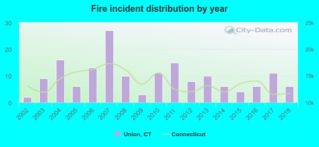 Based on the data from the years 2002 - 2018 the average number of fires per year is 10. The highest number of reported fires - 27 took place in 2007, and the least - 2 in 2002. The data has an increasing trend.
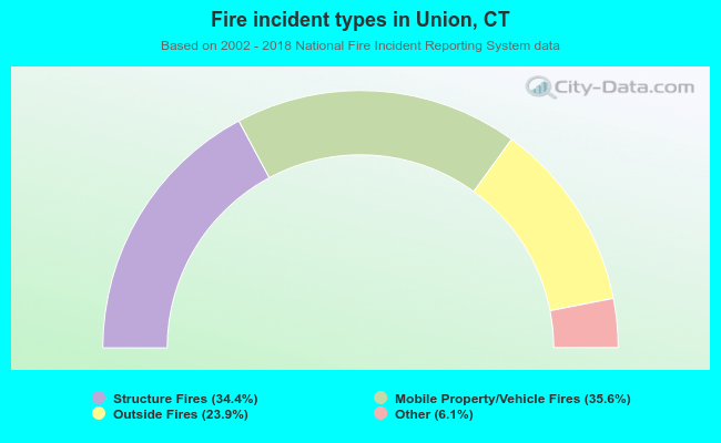 When looking into fire subcategories, the most incidents belonged to: Mobile Property/Vehicle Fires (35.6%), and Structure Fires (34.4%).
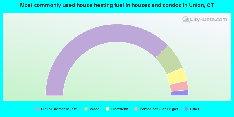
- 75.3%Fuel oil, kerosene, etc.
- 11.9%Wood
- 6.2%Electricity
- 4.1%Bottled, tank, or LP gas
- 1.6%Other fuel
- 0.8%Utility gas
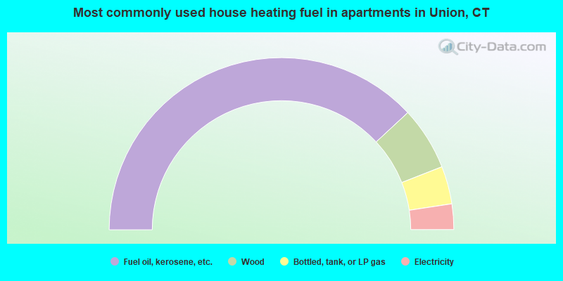
- 76.2%Fuel oil, kerosene, etc.
- 11.9%Wood
- 7.1%Bottled, tank, or LP gas
- 4.8%Electricity
Union compared to Connecticut state average:
- Unemployed percentage significantly below state average.
- Black race population percentage significantly below state average.
- Hispanic race population percentage significantly below state average.
- Median age above state average.
- Foreign-born population percentage significantly below state average.
- Renting percentage significantly below state average.
- Length of stay since moving in significantly above state average.
- Number of rooms per house significantly below state average.
- House age significantly below state average.
- Number of college students below state average.

|
|
Total of 18 patent applications in 2008-2024.