Bridge Statistics for Upper Sandusky, Ohio (OH)
Condition, Traffic, Stress, Structural Evaluation, Project Costs
- National Bridge Inventory (NBI) Statistics
- 90Number of bridges
- 965ft / 294mTotal length
- $738,000Total costs
- 391,534Total average daily traffic
- 106,416Total average daily truck traffic
- National Bridge Inventory (NBI) Registered Bridges for Upper Sandusky
- No street view available for this location
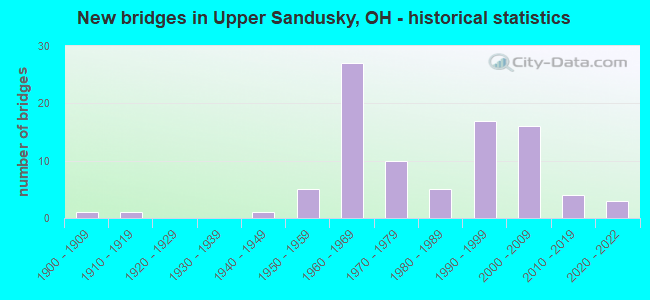
- New bridges - historical statistics
- 11900-1909
- 11910-1919
- 11940-1949
- 51950-1959
- 271960-1969
- 101970-1979
- 51980-1989
- 171990-1999
- 162000-2009
- 42010-2019
- 32020-2022

- Reconstructed bridges - Historical Statistics
- 21970-1979
- 01980-1989
- 21990-1999
- 42000-2009
- 32010-2019


- Bridge Condition - Deck
- 27.1%Excellent
- 20.0%Very good
- 42.9%Good
- 8.6%Satisfactory
- 1.4%Fair

- Bridge Condition - Superstructure
- 31.4%Excellent
- 22.9%Very good
- 37.1%Good
- 8.6%Satisfactory

- Bridge Condition - Substructure
- 28.6%Excellent
- 32.9%Very good
- 34.3%Good
- 4.3%Satisfactory

- Bridge Condition - Channel
- 17.3%Excellent
- 44.2%Very good
- 28.8%Good
- 9.6%Satisfactory

- Bridge Condition - Culverts
- 33.3%Excellent
- 66.7%Good
Find on map >> Show street view
Structure Number: 8800324, Location: 1/2 MI SOUTH OF US-30 (Lat: 40.803639, Lng: -83.235911), Route carried "on" structure: County highway C0056, Year Built: 2003, Status: Open, Structure Length: 5.93m (19.46ft), Average Daily Traffic: 225 (year 2015), Truck Traffic: 8%, Average Future Daily Traffic: 27,190 (year 2035), Design Load: HS 20+Mod, Features Intersected: USR 23, Facility Carried by Structure: CR 56
Minimum Vertical Clearance: 30+ m (98+ ft), Kilometerpoint: 0.998, Lanes on structure: 2, Lanes under structure: 11, Owner: State Highway Agency, Approaching Roadway Width: 6.6m (21.7ft), Material/Design: Prestressed concrete continuous, Design/Construction: Stringer/Multi-beam, Number Of Spans In Main Unit: 2, Length of Maximum Span: 29.4m (96.5ft), Curb-To-Curb Width: 9.0m (29.5ft), Out-to-Out Width: 9.9m (32.5ft)
Condition: Deck: Very good, Superstructure: Very good, Substructure: Very good, Operating Rating: 42.1 metric tons, Method Used To Determine Operating Rating: Load Factor (LF) rating reported by rating factor (RF) method using MS18 loading, Inventory Rating: 32.4 metric tons, Method Used To Determine Inventory Rating: Load Factor (LF) rating reported by rating factor (RF) method using MS18 loading, Structural Evaluation: Equal to present desirable criteria, Deck Geometry: Equal to present minimum criteria, Underclear: Better than present minimum criteria, Approach Roadway Alignment: Equal to present minimum criteria, Designated Inspection Frequency: Every 24 months, Inspection Date: July 2021, Deck Structure Type: Concrete Cast-file-Place, Wearing Surface/Protective System: Wearing Surface: Monolithic Concrete, Deck Protection: Epoxy Coated Reinforcing
Find on map >> Show street view
Structure Number: 8800332, Location: 1.7 mi. South of USR 30 (Lat: 40.788031, Lng: -83.242539), Route carried "on" structure: US 23, Year Built: 1965, Year Reconstructed: 2009, Status: Open, Structure Length: 6.83m (22.41ft), Average Daily Traffic: 7,563 (year 2015), Truck Traffic: 27%, Average Future Daily Traffic: 10,497 (year 2035), Design Load: HS 20+Mod, Features Intersected: SANDUSKY RIVER
Minimum Vertical Clearance: 30+ m (98+ ft), Kilometerpoint: 12.344, Lanes on structure: 2, Base Highway Network: Yes, Owner: State Highway Agency, Approaching Roadway Width: 9.1m (29.9ft), Material/Design: Steel continuous, Design/Construction: Stringer/Multi-beam, Number Of Spans In Main Unit: 3, Length of Maximum Span: 25.0m (82.0ft), Curb-To-Curb Width: 9.1m (29.9ft), Out-to-Out Width: 10.4m (34.1ft)
Condition: Deck: Good, Superstructure: Good, Substructure: Good, Channel: Good, Operating Rating: 42.1 metric tons, Method Used To Determine Operating Rating: Load Factor (LF) rating reported by rating factor (RF) method using MS18 loading, Inventory Rating: 32.4 metric tons, Method Used To Determine Inventory Rating: Load Factor (LF) rating reported by rating factor (RF) method using MS18 loading, Structural Evaluation: Better than present minimum criteria, Deck Geometry: Meets minimum limits, Waterway Adequacy: Equal to present desirable criteria, Approach Roadway Alignment: Equal to present desirable criteria, Length Of Structure Improvement: 7.62m (25.00ft), Designated Inspection Frequency: Every 24 months, Inspection Date: June 2021, Bridge Improvement Cost: $60,000, Roadway Improvement Cost: $6,000, Total Project Cost: $70,000, Deck Structure Type: Concrete Cast-file-Place, Wearing Surface/Protective System: Wearing Surface: Integral Concrete
Find on map >> Show street view
Structure Number: 8800367, Location: 1.7 mi. South of USR 30 (Lat: 40.787931, Lng: -83.242311), Route carried "on" structure: US 23, Year Built: 1965, Year Reconstructed: 2009, Status: Open, Structure Length: 6.83m (22.41ft), Average Daily Traffic: 7,563 (year 2015), Truck Traffic: 27%, Average Future Daily Traffic: 10,497 (year 2035), Design Load: HS 20+Mod, Features Intersected: SANDUSKY RIVER
Minimum Vertical Clearance: 30+ m (98+ ft), Kilometerpoint: 12.344, Lanes on structure: 2, Base Highway Network: Yes, Owner: State Highway Agency, Approaching Roadway Width: 9.1m (29.9ft), Material/Design: Steel continuous, Design/Construction: Stringer/Multi-beam, Number Of Spans In Main Unit: 3, Length of Maximum Span: 25.0m (82.0ft), Curb-To-Curb Width: 9.1m (29.9ft), Out-to-Out Width: 10.4m (34.1ft)
Condition: Deck: Good, Superstructure: Good, Substructure: Good, Channel: Good, Operating Rating: 42.1 metric tons, Method Used To Determine Operating Rating: Load Factor (LF) rating reported by rating factor (RF) method using MS18 loading, Inventory Rating: 32.4 metric tons, Method Used To Determine Inventory Rating: Load Factor (LF) rating reported by rating factor (RF) method using MS18 loading, Structural Evaluation: Better than present minimum criteria, Deck Geometry: Meets minimum limits, Waterway Adequacy: Equal to present desirable criteria, Approach Roadway Alignment: Equal to present desirable criteria, Length Of Structure Improvement: 7.62m (25.00ft), Designated Inspection Frequency: Every 24 months, Inspection Date: June 2021, Bridge Improvement Cost: $60,000, Roadway Improvement Cost: $6,000, Total Project Cost: $70,000, Deck Structure Type: Concrete Cast-file-Place, Wearing Surface/Protective System: Wearing Surface: Integral Concrete
Find on map >> Show street view
Structure Number: 8800421, Location: 0.8 mi. North of USR 30 (Lat: 40.823081, Lng: -83.237061), Route carried "on" structure: US 23, Year Built: 1965, Status: Open, Structure Length: 4.45m (14.60ft), Average Daily Traffic: 12,026 (year 2015), Truck Traffic: 28%, Average Future Daily Traffic: 16,692 (year 2035), Design Load: HS 20+Mod, Features Intersected: CF&E/CSX RR
Minimum Vertical Clearance: 30+ m (98+ ft), Kilometerpoint: 16.367, Lanes on structure: 2, Base Highway Network: Yes, Owner: State Highway Agency, Approaching Roadway Width: 11.0m (36.1ft), Material/Design: Steel continuous, Design/Construction: Stringer/Multi-beam, Number Of Spans In Main Unit: 3, Length of Maximum Span: 15.9m (52.2ft), Curb or Sidewalk Widths: Left: 0.3m (1.0ft), Right: 0.3m (1.0ft), Curb-To-Curb Width: 11.6m (38.1ft), Out-to-Out Width: 12.9m (42.3ft)
Condition: Deck: Good, Superstructure: Good, Substructure: Good, Operating Rating: 42.1 metric tons, Method Used To Determine Operating Rating: Load Factor (LF) rating reported by rating factor (RF) method using MS18 loading, Inventory Rating: 32.4 metric tons, Method Used To Determine Inventory Rating: Load Factor (LF) rating reported by rating factor (RF) method using MS18 loading, Structural Evaluation: Better than present minimum criteria, Deck Geometry: Better than present minimum criteria, Underclear: Equal to present minimum criteria, Approach Roadway Alignment: Equal to present desirable criteria, Length Of Structure Improvement: 5.33m (17.49ft), Designated Inspection Frequency: Every 24 months, Inspection Date: June 2021, Bridge Improvement Cost: $55,000, Roadway Improvement Cost: $6,000, Total Project Cost: $65,000, Deck Structure Type: Concrete Cast-file-Place, Wearing Surface/Protective System: Wearing Surface: Integral Concrete
Find on map >> Show street view
Structure Number: 8800456, Location: 0.8 mi. North of USR 30 (Lat: 40.823069, Lng: -83.236761), Route carried "on" structure: US 23, Year Built: 1965, Status: Open, Structure Length: 4.45m (14.60ft), Average Daily Traffic: 12,026 (year 2015), Truck Traffic: 28%, Average Future Daily Traffic: 16,692 (year 2035), Design Load: HS 20+Mod, Features Intersected: CF&E/CSX RR
Minimum Vertical Clearance: 30+ m (98+ ft), Kilometerpoint: 16.367, Lanes on structure: 2, Base Highway Network: Yes, Owner: State Highway Agency, Approaching Roadway Width: 11.0m (36.1ft), Material/Design: Steel continuous, Design/Construction: Stringer/Multi-beam, Number Of Spans In Main Unit: 3, Length of Maximum Span: 15.9m (52.2ft), Curb or Sidewalk Widths: Left: 0.3m (1.0ft), Right: 0.3m (1.0ft), Curb-To-Curb Width: 11.6m (38.1ft), Out-to-Out Width: 12.9m (42.3ft)
Condition: Deck: Good, Superstructure: Good, Substructure: Good, Operating Rating: 42.1 metric tons, Method Used To Determine Operating Rating: Load Factor (LF) rating reported by rating factor (RF) method using MS18 loading, Inventory Rating: 32.4 metric tons, Method Used To Determine Inventory Rating: Load Factor (LF) rating reported by rating factor (RF) method using MS18 loading, Structural Evaluation: Better than present minimum criteria, Deck Geometry: Better than present minimum criteria, Underclear: Equal to present minimum criteria, Approach Roadway Alignment: Equal to present desirable criteria, Length Of Structure Improvement: 5.33m (17.49ft), Designated Inspection Frequency: Every 24 months, Inspection Date: June 2021, Bridge Improvement Cost: $55,000, Roadway Improvement Cost: $6,000, Total Project Cost: $65,000, Deck Structure Type: Concrete Cast-file-Place, Wearing Surface/Protective System: Wearing Surface: Integral Concrete
Find on map >> Show street view
Structure Number: 880048, Location: OVER CR 182 (Lat: 40.825561, Lng: -83.237181), Route carried "on" structure: US 23, Year Built: 1965, Status: Open, Structure Length: 3.63m (11.91ft), Average Daily Traffic: 12,026 (year 2015), Truck Traffic: 28%, Average Future Daily Traffic: 16,692 (year 2035), Design Load: HS 20, Features Intersected: CR 182
Minimum Vertical Clearance: 30+ m (98+ ft), Kilometerpoint: 16.641, Lanes on structure: 2, Lanes under structure: 2, Base Highway Network: Yes, Owner: State Highway Agency, Approaching Roadway Width: 12.8m (42.0ft), Material/Design: Concrete continuous, Design/Construction: Slab, Number Of Spans In Main Unit: 3, Length of Maximum Span: 12.8m (42.0ft), Curb or Sidewalk Widths: Left: 0.3m (1.0ft), Right: 0.3m (1.0ft), Curb-To-Curb Width: 13.5m (44.3ft), Out-to-Out Width: 14.8m (48.6ft)
Condition: Deck: Good, Superstructure: Good, Substructure: Good, Operating Rating: 61.6 metric tons, Method Used To Determine Operating Rating: Load Factor (LF) rating reported by rating factor (RF) method using MS18 loading, Inventory Rating: 35.6 metric tons, Method Used To Determine Inventory Rating: Load Factor (LF) rating reported by rating factor (RF) method using MS18 loading, Structural Evaluation: Better than present minimum criteria, Deck Geometry: Superior to present desirable criteria, Underclear: Equal to present minimum criteria, Approach Roadway Alignment: Equal to present desirable criteria, Length Of Structure Improvement: 4.57m (14.99ft), Designated Inspection Frequency: Every 24 months, Inspection Date: June 2021, Bridge Improvement Cost: $55,000, Roadway Improvement Cost: $6,000, Total Project Cost: $65,000, Deck Structure Type: Concrete Cast-file-Place, Wearing Surface/Protective System: Wearing Surface: Integral Concrete
Find on map >> Show street view
Structure Number: 880051, Location: OVER CR 182 (Lat: 40.825550, Lng: -83.236869), Route carried "on" structure: US 23, Year Built: 1965, Status: Open, Structure Length: 3.63m (11.91ft), Average Daily Traffic: 12,026 (year 2015), Truck Traffic: 28%, Average Future Daily Traffic: 16,692 (year 2035), Design Load: HS 20, Features Intersected: CR 182
Minimum Vertical Clearance: 30+ m (98+ ft), Kilometerpoint: 16.641, Lanes on structure: 2, Lanes under structure: 2, Base Highway Network: Yes, Owner: State Highway Agency, Approaching Roadway Width: 11.6m (38.1ft), Material/Design: Concrete continuous, Design/Construction: Slab, Number Of Spans In Main Unit: 3, Length of Maximum Span: 12.8m (42.0ft), Curb or Sidewalk Widths: Left: 0.3m (1.0ft), Right: 0.3m (1.0ft), Curb-To-Curb Width: 11.6m (38.1ft), Out-to-Out Width: 12.9m (42.3ft)
Condition: Deck: Good, Superstructure: Good, Substructure: Good, Operating Rating: 61.6 metric tons, Method Used To Determine Operating Rating: Load Factor (LF) rating reported by rating factor (RF) method using MS18 loading, Inventory Rating: 35.6 metric tons, Method Used To Determine Inventory Rating: Load Factor (LF) rating reported by rating factor (RF) method using MS18 loading, Structural Evaluation: Better than present minimum criteria, Deck Geometry: Better than present minimum criteria, Underclear: Equal to present minimum criteria, Approach Roadway Alignment: Equal to present desirable criteria, Length Of Structure Improvement: 4.57m (14.99ft), Designated Inspection Frequency: Every 24 months, Inspection Date: June 2021, Bridge Improvement Cost: $55,000, Roadway Improvement Cost: $6,000, Total Project Cost: $65,000, Deck Structure Type: Concrete Cast-file-Place, Wearing Surface/Protective System: Wearing Surface: Integral Concrete
Find on map >> Show street view
Structure Number: 8800545, Location: OLD 30 (Lat: 40.834461, Lng: -83.241019), Route carried "on" structure: US 23, Year Built: 1964, Status: Open, Structure Length: 4.21m (13.81ft), Average Daily Traffic: 11,803 (year 2015), Truck Traffic: 28%, Average Future Daily Traffic: 16,383 (year 2035), Design Load: HS 20+Mod, Features Intersected: CR 330
Minimum Vertical Clearance: 30+ m (98+ ft), Kilometerpoint: 17.719, Lanes on structure: 2, Lanes under structure: 2, Base Highway Network: Yes, Owner: State Highway Agency, Approaching Roadway Width: 11.0m (36.1ft), Skew: 2 degrees, Material/Design: Concrete continuous, Design/Construction: Slab, Number Of Spans In Main Unit: 3, Length of Maximum Span: 14.9m (48.9ft), Curb or Sidewalk Widths: Left: 0.3m (1.0ft), Right: 0.3m (1.0ft), Curb-To-Curb Width: 11.5m (37.7ft), Out-to-Out Width: 12.9m (42.3ft)
Condition: Deck: Good, Superstructure: Good, Substructure: Good, Operating Rating: 42.1 metric tons, Method Used To Determine Operating Rating: Load Factor (LF) rating reported by rating factor (RF) method using MS18 loading, Inventory Rating: 32.4 metric tons, Method Used To Determine Inventory Rating: Load Factor (LF) rating reported by rating factor (RF) method using MS18 loading, Structural Evaluation: Better than present minimum criteria, Deck Geometry: Equal to present minimum criteria, Underclear: Equal to present minimum criteria, Approach Roadway Alignment: Equal to present desirable criteria, Designated Inspection Frequency: Every 24 months, Inspection Date: July 2021, Deck Structure Type: Concrete Cast-file-Place, Wearing Surface/Protective System: Wearing Surface: Integral Concrete
Find on map >> Show street view
Structure Number: 8800634, Location: OLD US 30 (Lat: 40.834539, Lng: -83.240711), Route carried "on" structure: US 23, Year Built: 1964, Status: Open, Structure Length: 4.21m (13.81ft), Average Daily Traffic: 11,803 (year 2015), Truck Traffic: 28%, Average Future Daily Traffic: 16,383 (year 2035), Design Load: HS 20+Mod, Features Intersected: CR 330
Minimum Vertical Clearance: 30+ m (98+ ft), Kilometerpoint: 17.719, Lanes on structure: 2, Lanes under structure: 2, Base Highway Network: Yes, Owner: State Highway Agency, Approaching Roadway Width: 11.0m (36.1ft), Skew: 2 degrees, Material/Design: Concrete continuous, Design/Construction: Slab, Number Of Spans In Main Unit: 3, Length of Maximum Span: 14.9m (48.9ft), Curb or Sidewalk Widths: Left: 0.3m (1.0ft), Right: 0.3m (1.0ft), Curb-To-Curb Width: 11.5m (37.7ft), Out-to-Out Width: 12.9m (42.3ft)
Condition: Deck: Good, Superstructure: Good, Substructure: Good, Operating Rating: 42.1 metric tons, Method Used To Determine Operating Rating: Load Factor (LF) rating reported by rating factor (RF) method using MS18 loading, Inventory Rating: 32.4 metric tons, Method Used To Determine Inventory Rating: Load Factor (LF) rating reported by rating factor (RF) method using MS18 loading, Structural Evaluation: Better than present minimum criteria, Deck Geometry: Equal to present minimum criteria, Underclear: Equal to present minimum criteria, Approach Roadway Alignment: Equal to present desirable criteria, Designated Inspection Frequency: Every 24 months, Inspection Date: July 2021, Deck Structure Type: Concrete Cast-file-Place, Wearing Surface/Protective System: Wearing Surface: Latex Concrete
Find on map >> Show street view
Structure Number: 8800669, Location: 1.25 mi. East of SR 53 (Lat: 40.849381, Lng: -83.259800), Route carried "on" structure: US 23, Year Built: 1963, Status: Open, Structure Length: 6.83m (22.41ft), Average Daily Traffic: 11,580 (year 2015), Truck Traffic: 27%, Average Future Daily Traffic: 16,073 (year 2035), Design Load: HS 20+Mod, Features Intersected: SANDUSKY RIVER
Minimum Vertical Clearance: 30+ m (98+ ft), Kilometerpoint: 20.020, Lanes on structure: 2, Base Highway Network: Yes, Owner: State Highway Agency, Approaching Roadway Width: 9.1m (29.9ft), Skew: 1 degrees, Material/Design: Steel continuous, Design/Construction: Stringer/Multi-beam, Number Of Spans In Main Unit: 3, Length of Maximum Span: 25.0m (82.0ft), Curb or Sidewalk Widths: Left: 0.6m (2.0ft), Right: 0.6m (2.0ft), Curb-To-Curb Width: 9.1m (29.9ft), Out-to-Out Width: 11.3m (37.1ft)
Condition: Deck: Satisfactory, Superstructure: Good, Substructure: Good, Channel: Very good, Operating Rating: 42.1 metric tons, Method Used To Determine Operating Rating: Allowable Stress (AS) rating reported by rating factor (RF) method using MS18 loading, Inventory Rating: 32.4 metric tons, Method Used To Determine Inventory Rating: Allowable Stress (AS) rating reported by rating factor (RF) method using MS18 loading, Structural Evaluation: Better than present minimum criteria, Deck Geometry: Meets minimum limits, Waterway Adequacy: Equal to present desirable criteria, Approach Roadway Alignment: Equal to present desirable criteria, Designated Inspection Frequency: Every 12 months, Inspection Date: June 2021, Deck Structure Type: Concrete Cast-file-Place, Wearing Surface/Protective System: Wearing Surface: Latex Concrete
Find on map >> Show street view
Structure Number: 8800693, Location: 1.25 mi. East of SR 53 (Lat: 40.849561, Lng: -83.259639), Route carried "on" structure: US 23, Year Built: 1963, Status: Open, Structure Length: 6.83m (22.41ft), Average Daily Traffic: 11,580 (year 2015), Truck Traffic: 27%, Average Future Daily Traffic: 16,073 (year 2035), Design Load: HS 20+Mod, Features Intersected: SANDUSKY RIVER
Minimum Vertical Clearance: 30+ m (98+ ft), Kilometerpoint: 20.020, Lanes on structure: 2, Base Highway Network: Yes, Owner: State Highway Agency, Approaching Roadway Width: 9.1m (29.9ft), Skew: 1 degrees, Material/Design: Steel continuous, Design/Construction: Stringer/Multi-beam, Number Of Spans In Main Unit: 3, Length of Maximum Span: 25.0m (82.0ft), Curb or Sidewalk Widths: Left: 0.6m (2.0ft), Right: 0.6m (2.0ft), Curb-To-Curb Width: 9.1m (29.9ft), Out-to-Out Width: 11.3m (37.1ft)
Condition: Deck: Good, Superstructure: Good, Substructure: Good, Channel: Very good, Operating Rating: 61.6 metric tons, Method Used To Determine Operating Rating: Load Factor (LF) rating reported by rating factor (RF) method using MS18 loading, Inventory Rating: 35.6 metric tons, Method Used To Determine Inventory Rating: Load Factor (LF) rating reported by rating factor (RF) method using MS18 loading, Structural Evaluation: Better than present minimum criteria, Deck Geometry: Meets minimum limits, Waterway Adequacy: Equal to present desirable criteria, Approach Roadway Alignment: Equal to present desirable criteria, Designated Inspection Frequency: Every 24 months, Inspection Date: June 2021, Deck Structure Type: Concrete Cast-file-Place, Wearing Surface/Protective System: Wearing Surface: Latex Concrete
Find on map >> Show street view
Structure Number: 8800758, Location: 1.26 mi. West of SR 53 (Lat: 40.858150, Lng: -83.302811), Route carried "on" structure: US 23, Year Built: 1963, Status: Open, Structure Length: 4.21m (13.81ft), Average Daily Traffic: 10,920 (year 2015), Truck Traffic: 26%, Average Future Daily Traffic: 15,157 (year 2035), Design Load: HS 20+Mod, Features Intersected: SR 199
Minimum Vertical Clearance: 30+ m (98+ ft), Kilometerpoint: 24.044, Lanes on structure: 3, Lanes under structure: 2, Base Highway Network: Yes, Owner: State Highway Agency, Approaching Roadway Width: 14.3m (46.9ft), Skew: 3 degrees, Material/Design: Steel continuous, Design/Construction: Stringer/Multi-beam, Number Of Spans In Main Unit: 3, Length of Maximum Span: 16.2m (53.1ft), Curb or Sidewalk Widths: Left: 0.3m (1.0ft), Right: 0.3m (1.0ft), Curb-To-Curb Width: 14.5m (47.6ft), Out-to-Out Width: 16.0m (52.5ft)
Condition: Deck: Good, Superstructure: Satisfactory, Substructure: Good, Operating Rating: 42.1 metric tons, Method Used To Determine Operating Rating: Allowable Stress (AS) rating reported by rating factor (RF) method using MS18 loading, Inventory Rating: 32.4 metric tons, Method Used To Determine Inventory Rating: Allowable Stress (AS) rating reported by rating factor (RF) method using MS18 loading, Structural Evaluation: Equal to present minimum criteria, Deck Geometry: Somewhat better than minimum adequacy, Underclear: Equal to present minimum criteria, Approach Roadway Alignment: Equal to present desirable criteria, Designated Inspection Frequency: Every 12 months, Inspection Date: June 2021, Deck Structure Type: Concrete Cast-file-Place, Wearing Surface/Protective System: Wearing Surface: Latex Concrete
Find on map >> Show street view
Structure Number: 8800782, Location: 1.26 mi. West of SR 53 (Lat: 40.858389, Lng: -83.303031), Route carried "on" structure: US 23, Year Built: 1963, Status: Open, Structure Length: 4.21m (13.81ft), Average Daily Traffic: 10,920 (year 2015), Truck Traffic: 26%, Average Future Daily Traffic: 15,157 (year 2035), Design Load: HS 20+Mod, Features Intersected: SR 199
Minimum Vertical Clearance: 30+ m (98+ ft), Kilometerpoint: 24.044, Lanes on structure: 3, Lanes under structure: 2, Base Highway Network: Yes, Owner: State Highway Agency, Approaching Roadway Width: 20.1m (65.9ft), Skew: 3 degrees, Material/Design: Steel continuous, Design/Construction: Stringer/Multi-beam, Number Of Spans In Main Unit: 3, Length of Maximum Span: 13.7m (44.9ft), Curb or Sidewalk Widths: Left: 0.3m (1.0ft), Right: 0.3m (1.0ft), Curb-To-Curb Width: 20.1m (65.9ft), Out-to-Out Width: 21.2m (69.6ft)
Condition: Deck: Good, Superstructure: Good, Substructure: Good, Operating Rating: 42.1 metric tons, Method Used To Determine Operating Rating: Allowable Stress (AS) rating reported by rating factor (RF) method using MS18 loading, Inventory Rating: 32.4 metric tons, Method Used To Determine Inventory Rating: Allowable Stress (AS) rating reported by rating factor (RF) method using MS18 loading, Structural Evaluation: Better than present minimum criteria, Deck Geometry: Superior to present desirable criteria, Underclear: Equal to present minimum criteria, Approach Roadway Alignment: Equal to present desirable criteria, Designated Inspection Frequency: Every 24 months, Inspection Date: June 2021, Deck Structure Type: Concrete Cast-file-Place, Wearing Surface/Protective System: Wearing Surface: Latex Concrete
Find on map >> Show street view
Structure Number: 8800812, Location: 0.3 mi. West of SR 199 (Lat: 40.858061, Lng: -83.308811), Route carried "on" structure: US 23, Year Built: 1964, Status: Open, Structure Length: 5.88m (19.29ft), Average Daily Traffic: 10,116 (year 2015), Truck Traffic: 26%, Average Future Daily Traffic: 14,041 (year 2035), Design Load: HS 20, Features Intersected: CSX RR
Minimum Vertical Clearance: 30+ m (98+ ft), Kilometerpoint: 24.559, Lanes on structure: 2, Base Highway Network: Yes, Owner: State Highway Agency, Approaching Roadway Width: 11.0m (36.1ft), Skew: 1 degrees, Material/Design: Steel continuous, Design/Construction: Stringer/Multi-beam, Number Of Spans In Main Unit: 3, Number Of Approach Spans: 1, Length of Maximum Span: 16.8m (55.1ft), Curb or Sidewalk Widths: Left: 0.3m (1.0ft), Right: 0.3m (1.0ft), Curb-To-Curb Width: 11.5m (37.7ft), Out-to-Out Width: 12.9m (42.3ft)
Condition: Deck: Good, Superstructure: Good, Substructure: Good, Operating Rating: 48.6 metric tons, Method Used To Determine Operating Rating: Load Factor (LF) rating reported by rating factor (RF) method using MS18 loading, Inventory Rating: 29.2 metric tons, Method Used To Determine Inventory Rating: Load Factor (LF) rating reported by rating factor (RF) method using MS18 loading, Structural Evaluation: Better than present minimum criteria, Deck Geometry: Equal to present minimum criteria, Underclear: Better than present minimum criteria, Approach Roadway Alignment: Equal to present desirable criteria, Designated Inspection Frequency: Every 24 months, Inspection Date: June 2021, Deck Structure Type: Concrete Cast-file-Place, Wearing Surface/Protective System: Wearing Surface: Integral Concrete
Find on map >> Show street view
Structure Number: 8800847, Location: 0.3 mi. West of SR 199 (Lat: 40.858411, Lng: -83.309039), Route carried "on" structure: US 23, Year Built: 1964, Status: Posted for load, Structure Length: 6.25m (20.51ft), Average Daily Traffic: 10,116 (year 2015), Truck Traffic: 26%, Average Future Daily Traffic: 14,041 (year 2035), Design Load: HS 20, Features Intersected: CSX RR
Minimum Vertical Clearance: 30+ m (98+ ft), Kilometerpoint: 24.559, Lanes on structure: 2, Base Highway Network: Yes, Owner: State Highway Agency, Approaching Roadway Width: 11.0m (36.1ft), Skew: 2 degrees, Material/Design: Steel continuous, Design/Construction: Stringer/Multi-beam, Number Of Spans In Main Unit: 3, Number Of Approach Spans: 1, Length of Maximum Span: 18.9m (62.0ft), Curb or Sidewalk Widths: Left: 0.3m (1.0ft), Right: 0.3m (1.0ft), Curb-To-Curb Width: 11.5m (37.7ft), Out-to-Out Width: 12.9m (42.3ft)
Condition: Deck: Good, Superstructure: Good, Substructure: Satisfactory, Operating Rating: 42.1 metric tons, Method Used To Determine Operating Rating: Load Factor (LF) rating reported by rating factor (RF) method using MS18 loading, Inventory Rating: 25.9 metric tons, Method Used To Determine Inventory Rating: Load Factor (LF) rating reported by rating factor (RF) method using MS18 loading, Structural Evaluation: Equal to present minimum criteria, Deck Geometry: Equal to present minimum criteria, Underclear: Better than present minimum criteria, Approach Roadway Alignment: Equal to present desirable criteria, Bridge Posting: Required (Relationship of Operating Rating to Maximum Legal Load: 0.1 - 9.9% below), Designated Inspection Frequency: Every 12 months, Inspection Date: June 2021, Deck Structure Type: Concrete Cast-file-Place, Wearing Surface/Protective System: Wearing Surface: Integral Concrete
Find on map >> Show street view
Structure Number: 8800863, Location: JCT OF US 30 AND US 23 (Lat: 40.858969, Lng: -83.321289), Route carried "on" structure: US 23, Year Built: 1992, Status: Open, Structure Length: 2.80m (9.19ft), Average Daily Traffic: 3,632 (year 2015), Truck Traffic: 25%, Average Future Daily Traffic: 5,041 (year 2035), Design Load: HS 20+Mod, Features Intersected: LITTLE TYMOCHTEE CREEK
Minimum Vertical Clearance: 30+ m (98+ ft), Kilometerpoint: 25.572, Lanes on structure: 3, Base Highway Network: Yes, Owner: State Highway Agency, Approaching Roadway Width: 15.5m (50.9ft), Skew: 2 degrees, Material/Design: Prestressed concrete, Design/Construction: Stringer/Multi-beam, Number Of Spans In Main Unit: 1, Length of Maximum Span: 27.4m (89.9ft), Curb-To-Curb Width: 15.6m (51.2ft), Out-to-Out Width: 16.5m (54.1ft)
Condition: Deck: Excellent, Superstructure: Excellent, Substructure: Excellent, Channel: Very good, Operating Rating: 87.5 metric tons, Method Used To Determine Operating Rating: Load Factor (LF) rating reported by rating factor (RF) method using MS18 loading, Inventory Rating: 38.9 metric tons, Method Used To Determine Inventory Rating: Load Factor (LF) rating reported by rating factor (RF) method using MS18 loading, Structural Evaluation: Superior to present desirable criteria, Deck Geometry: Equal to present minimum criteria, Waterway Adequacy: Superior to present desirable criteria, Approach Roadway Alignment: Superior to present desirable criteria, Designated Inspection Frequency: Every 24 months, Inspection Date: July 2021, Deck Structure Type: Other, Wearing Surface/Protective System: Wearing Surface: Integral Concrete, Deck Protection: Epoxy Coated Reinforcing
Find on map >> Show street view
Structure Number: 8800898, Location: JCT OF US 30 AND US 23 (Lat: 40.860150, Lng: -83.320519), Route carried "on" structure: US 23, Year Built: 1992, Status: Open, Structure Length: 2.50m (8.20ft), Average Daily Traffic: 3,632 (year 2015), Truck Traffic: 25%, Average Future Daily Traffic: 5,041 (year 2035), Design Load: HS 20+Mod, Features Intersected: LITTLE TYMOCHTEE CREEK
Minimum Vertical Clearance: 30+ m (98+ ft), Kilometerpoint: 25.572, Lanes on structure: 3, Base Highway Network: Yes, Owner: State Highway Agency, Approaching Roadway Width: 21.3m (69.9ft), Skew: 2 degrees, Material/Design: Prestressed concrete, Design/Construction: Stringer/Multi-beam, Number Of Spans In Main Unit: 1, Length of Maximum Span: 24.4m (80.1ft), Curb-To-Curb Width: 21.3m (69.9ft), Out-to-Out Width: 22.2m (72.8ft)
Condition: Deck: Very good, Superstructure: Excellent, Substructure: Excellent, Channel: Very good, Operating Rating: 90.7 metric tons, Method Used To Determine Operating Rating: Load Factor (LF) rating reported by rating factor (RF) method using MS18 loading, Inventory Rating: 35.6 metric tons, Method Used To Determine Inventory Rating: Load Factor (LF) rating reported by rating factor (RF) method using MS18 loading, Structural Evaluation: Superior to present desirable criteria, Deck Geometry: Superior to present desirable criteria, Waterway Adequacy: Superior to present desirable criteria, Approach Roadway Alignment: Superior to present desirable criteria, Designated Inspection Frequency: Every 24 months, Inspection Date: July 2021, Deck Structure Type: Other, Wearing Surface/Protective System: Wearing Surface: Integral Concrete, Deck Protection: Epoxy Coated Reinforcing
Find on map >> Show street view
Structure Number: 8800928, Location: .2 MI NORTH OF JCT 23-30 (Lat: 40.861519, Lng: -83.322500), Route carried "on" structure: County highway CR047, Year Built: 1993, Status: Open, Structure Length: 10.55m (34.61ft), Average Daily Traffic: 401 (year 2015), Truck Traffic: 7%, Average Future Daily Traffic: 10,082 (year 2035), Design Load: HS 20+Mod, Features Intersected: USR 23, Facility Carried by Structure: CR 47
Minimum Vertical Clearance: 30+ m (98+ ft), Kilometerpoint: 0.000, Lanes on structure: 2, Lanes under structure: 4, Owner: State Highway Agency, Approaching Roadway Width: 10.4m (34.1ft), Skew: 2 degrees, Material/Design: Steel continuous, Design/Construction: Stringer/Multi-beam, Number Of Spans In Main Unit: 4, Length of Maximum Span: 35.7m (117.1ft), Curb-To-Curb Width: 10.4m (34.1ft), Out-to-Out Width: 11.3m (37.1ft)
Condition: Deck: Excellent, Superstructure: Excellent, Substructure: Excellent, Operating Rating: 42.1 metric tons, Method Used To Determine Operating Rating: Load Factor (LF) rating reported by rating factor (RF) method using MS18 loading, Inventory Rating: 32.4 metric tons, Method Used To Determine Inventory Rating: Load Factor (LF) rating reported by rating factor (RF) method using MS18 loading, Structural Evaluation: Equal to present desirable criteria, Deck Geometry: Equal to present minimum criteria, Underclear: Somewhat better than minimum adequacy, Approach Roadway Alignment: Superior to present desirable criteria, Designated Inspection Frequency: Every 24 months, Inspection Date: July 2021, Deck Structure Type: Concrete Cast-file-Place, Wearing Surface/Protective System: Wearing Surface: Monolithic Concrete, Deck Protection: Epoxy Coated Reinforcing
Find on map >> Show street view
Structure Number: 8801312, Location: .5 MI SW OF JCT US 23 (Lat: 40.846989, Lng: -83.326031), Route carried "on" structure: County highway T0049, Year Built: 1993, Status: Open, Structure Length: 8.17m (26.80ft), Average Daily Traffic: 40 (year 2015), Truck Traffic: 8%, Average Future Daily Traffic: 11,382 (year 2035), Design Load: HS 20+Mod, Features Intersected: USR 30, Facility Carried by Structure: TR 49
Minimum Vertical Clearance: 30+ m (98+ ft), Kilometerpoint: 0.000, Lanes on structure: 2, Lanes under structure: 4, Owner: State Highway Agency, Approaching Roadway Width: 9.1m (29.9ft), Skew: 2 degrees, Material/Design: Steel continuous, Design/Construction: Stringer/Multi-beam, Number Of Spans In Main Unit: 2, Length of Maximum Span: 40.5m (132.9ft), Curb-To-Curb Width: 9.1m (29.9ft), Out-to-Out Width: 10.1m (33.1ft)
Condition: Deck: Excellent, Superstructure: Excellent, Substructure: Excellent, Operating Rating: 42.1 metric tons, Method Used To Determine Operating Rating: Load Factor (LF) rating reported by rating factor (RF) method using MS18 loading, Inventory Rating: 32.4 metric tons, Method Used To Determine Inventory Rating: Load Factor (LF) rating reported by rating factor (RF) method using MS18 loading, Structural Evaluation: Equal to present desirable criteria, Deck Geometry: Better than present minimum criteria, Underclear: Superior to present desirable criteria, Approach Roadway Alignment: Superior to present desirable criteria, Designated Inspection Frequency: Every 24 months, Inspection Date: July 2021, Deck Structure Type: Concrete Cast-file-Place, Wearing Surface/Protective System: Wearing Surface: Monolithic Concrete, Deck Protection: Epoxy Coated Reinforcing
Find on map >> Show street view
Structure Number: 8801339, Location: JCT OF US 23 AND US 30 (Lat: 40.856800, Lng: -83.318811), Route carried "on" structure: Ramp US 30, Year Built: 1993, Status: Open, Structure Length: 7.99m (26.21ft), Average Daily Traffic: 6,581 (year 2010), Truck Traffic: 45%, Average Future Daily Traffic: 9,134 (year 2030), Design Load: HS 20+Mod, Features Intersected: USR 23 SB
Minimum Vertical Clearance: 5.08m (16.67ft), Kilometerpoint: 18.169, Lanes on structure: 2, Lanes under structure: 2, Owner: State Highway Agency, Approaching Roadway Width: 12.8m (42.0ft), Skew: 3 degrees, Material/Design: Steel continuous, Design/Construction: Stringer/Multi-beam, Number Of Spans In Main Unit: 3, Length of Maximum Span: 30.2m (99.1ft), Curb-To-Curb Width: 12.8m (42.0ft), Out-to-Out Width: 13.7m (44.9ft)
Condition: Deck: Good, Superstructure: Excellent, Substructure: Excellent, Operating Rating: 42.1 metric tons, Method Used To Determine Operating Rating: Load Factor (LF) rating reported by rating factor (RF) method using MS18 loading, Inventory Rating: 32.4 metric tons, Method Used To Determine Inventory Rating: Load Factor (LF) rating reported by rating factor (RF) method using MS18 loading, Structural Evaluation: Equal to present desirable criteria, Deck Geometry: Superior to present desirable criteria, Underclear: Somewhat better than minimum adequacy, Approach Roadway Alignment: Superior to present desirable criteria, Designated Inspection Frequency: Every 24 months, Inspection Date: July 2021, Deck Structure Type: Concrete Cast-file-Place, Wearing Surface/Protective System: Wearing Surface: Monolithic Concrete, Deck Protection: Epoxy Coated Reinforcing
Find on map >> Show street view
Structure Number: 8801347, Location: JCT OF US 23 AND US 30 (Lat: 40.857461, Lng: -83.318331), Route carried "on" structure: Ramp US 23, Year Built: 1993, Status: Open, Structure Length: 9.08m (29.79ft), Average Daily Traffic: 13,810 (year 2010), Truck Traffic: 26%, Average Future Daily Traffic: 19,168 (year 2030), Design Load: HS 20+Mod, Features Intersected: USR 30 W AND USR 23 S, Facility Carried by Structure: USR 30 EXIT RAMP
Minimum Vertical Clearance: 30+ m (98+ ft), Kilometerpoint: 25.218, Lanes on structure: 1, Lanes under structure: 2, Owner: State Highway Agency, Approaching Roadway Width: 9.1m (29.9ft), Material/Design: Steel continuous, Design/Construction: Stringer/Multi-beam, Number Of Spans In Main Unit: 3, Length of Maximum Span: 35.1m (115.2ft), Curb-To-Curb Width: 9.1m (29.9ft), Out-to-Out Width: 10.1m (33.1ft)
Condition: Deck: Excellent, Superstructure: Excellent, Substructure: Excellent, Operating Rating: 42.1 metric tons, Method Used To Determine Operating Rating: Load Factor (LF) rating reported by rating factor (RF) method using MS18 loading, Inventory Rating: 32.4 metric tons, Method Used To Determine Inventory Rating: Load Factor (LF) rating reported by rating factor (RF) method using MS18 loading, Structural Evaluation: Equal to present desirable criteria, Deck Geometry: Superior to present desirable criteria, Underclear: Equal to present minimum criteria, Approach Roadway Alignment: Equal to present desirable criteria, Designated Inspection Frequency: Every 24 months, Inspection Date: July 2021, Deck Structure Type: Concrete Cast-file-Place, Wearing Surface/Protective System: Wearing Surface: Monolithic Concrete, Deck Protection: Epoxy Coated Reinforcing
Find on map >> Show street view
Structure Number: 8801398, Location: CR 330 OVER USR 30 (Lat: 40.832419, Lng: -83.336381), Route carried "on" structure: County highway C0330, Year Built: 2008, Status: Open, Structure Length: 8.53m (27.99ft), Average Daily Traffic: 1,720 (year 2019), Truck Traffic: 5%, Average Future Daily Traffic: 1,855 (year 2039), Design Load: HS 25 or greater, Features Intersected: USR 30, Facility Carried by Structure: CR 330 (OLD-30)
Minimum Vertical Clearance: 30+ m (98+ ft), Kilometerpoint: 15.150, Lanes on structure: 2, Lanes under structure: 4, Base Highway Network: Yes, Owner: State Highway Agency, Approaching Roadway Width: 11.9m (39.0ft), Skew: 2 degrees, Material/Design: Steel continuous, Design/Construction: Stringer/Multi-beam, Number Of Spans In Main Unit: 2, Length of Maximum Span: 42.4m (139.1ft), Curb-To-Curb Width: 12.0m (39.4ft), Out-to-Out Width: 12.9m (42.3ft)
Condition: Deck: Excellent, Superstructure: Excellent, Substructure: Excellent, Operating Rating: 42.1 metric tons, Method Used To Determine Operating Rating: Load Factor (LF) rating reported by rating factor (RF) method using MS18 loading, Inventory Rating: 32.4 metric tons, Method Used To Determine Inventory Rating: Load Factor (LF) rating reported by rating factor (RF) method using MS18 loading, Structural Evaluation: Equal to present desirable criteria, Deck Geometry: Equal to present minimum criteria, Underclear: Better than present minimum criteria, Approach Roadway Alignment: Equal to present desirable criteria, Designated Inspection Frequency: Every 24 months, Inspection Date: June 2021, Deck Structure Type: Concrete Cast-file-Place, Wearing Surface/Protective System: Wearing Surface: Monolithic Concrete, Deck Protection: Epoxy Coated Reinforcing
Find on map >> Show street view
Structure Number: 8801444, Location: 3.5 MI WEST OF SR-293 (Lat: 40.825550, Lng: -83.356339), Route carried "on" structure: US 30, Year Built: 2007, Status: Open, Structure Length: 4.82m (15.81ft), Average Daily Traffic: 4,004 (year 2015), Truck Traffic: 41%, Average Future Daily Traffic: 5,558 (year 2035), Design Load: HS 25 or greater, Features Intersected: TYMOCHTEE RIVER
Minimum Vertical Clearance: 30+ m (98+ ft), Kilometerpoint: 13.486, Lanes on structure: 2, Base Highway Network: Yes, Owner: State Highway Agency, Approaching Roadway Width: 13.1m (43.0ft), Skew: 3 degrees, Material/Design: Prestressed concrete continuous, Design/Construction: Stringer/Multi-beam, Number Of Spans In Main Unit: 2, Length of Maximum Span: 23.2m (76.1ft), Curb-To-Curb Width: 13.8m (45.3ft), Out-to-Out Width: 14.7m (48.2ft)
Condition: Deck: Excellent, Superstructure: Excellent, Substructure: Excellent, Channel: Excellent, Operating Rating: 42.1 metric tons, Method Used To Determine Operating Rating: Load Factor (LF) rating reported by rating factor (RF) method using MS18 loading, Inventory Rating: 32.4 metric tons, Method Used To Determine Inventory Rating: Load Factor (LF) rating reported by rating factor (RF) method using MS18 loading, Structural Evaluation: Equal to present desirable criteria, Deck Geometry: Superior to present desirable criteria, Waterway Adequacy: Superior to present desirable criteria, Approach Roadway Alignment: Equal to present desirable criteria, Designated Inspection Frequency: Every 24 months, Inspection Date: July 2021, Deck Structure Type: Concrete Cast-file-Place, Wearing Surface/Protective System: Wearing Surface: Monolithic Concrete, Deck Protection: Epoxy Coated Reinforcing
Find on map >> Show street view
Structure Number: 8801452, Location: 3.5 MI EAST OF SR-293 (Lat: 40.825300, Lng: -83.356600), Route carried "on" structure: US 30, Year Built: 2007, Status: Open, Structure Length: 4.82m (15.81ft), Average Daily Traffic: 4,004 (year 2015), Truck Traffic: 41%, Average Future Daily Traffic: 5,558 (year 2035), Design Load: HS 25 or greater, Features Intersected: TYMOCHTEE RIVER
Minimum Vertical Clearance: 30+ m (98+ ft), Kilometerpoint: 13.486, Lanes on structure: 2, Base Highway Network: Yes, Owner: State Highway Agency, Approaching Roadway Width: 13.1m (43.0ft), Skew: 3 degrees, Material/Design: Prestressed concrete continuous, Design/Construction: Stringer/Multi-beam, Number Of Spans In Main Unit: 2, Length of Maximum Span: 23.2m (76.1ft), Curb-To-Curb Width: 13.8m (45.3ft), Out-to-Out Width: 14.7m (48.2ft)
Condition: Deck: Excellent, Superstructure: Excellent, Substructure: Excellent, Channel: Very good, Operating Rating: 42.1 metric tons, Method Used To Determine Operating Rating: Load Factor (LF) rating reported by rating factor (RF) method using MS18 loading, Inventory Rating: 32.4 metric tons, Method Used To Determine Inventory Rating: Load Factor (LF) rating reported by rating factor (RF) method using MS18 loading, Structural Evaluation: Equal to present desirable criteria, Deck Geometry: Superior to present desirable criteria, Waterway Adequacy: Superior to present desirable criteria, Approach Roadway Alignment: Equal to present desirable criteria, Designated Inspection Frequency: Every 24 months, Inspection Date: July 2021, Deck Structure Type: Concrete Cast-file-Place, Wearing Surface/Protective System: Wearing Surface: Monolithic Concrete, Deck Protection: Epoxy Coated Reinforcing
Find on map >> Show street view
Structure Number: 8801673, Location: .9MI.E.OF US.23 (Lat: 40.808769, Lng: -83.222339), Route carried "on" structure: County highway C0124, Year Built: 2003, Status: Open, Structure Length: 8.11m (26.61ft), Average Daily Traffic: 197 (year 2015), Truck Traffic: 8%, Average Future Daily Traffic: 12,321 (year 2035), Design Load: HS 25 or greater, Features Intersected: USR 30, Facility Carried by Structure: TR 124
Minimum Vertical Clearance: 30+ m (98+ ft), Kilometerpoint: 0.917, Lanes on structure: 2, Lanes under structure: 4, Owner: State Highway Agency, Approaching Roadway Width: 6.7m (22.0ft), Skew: 1 degrees, Material/Design: Prestressed concrete continuous, Design/Construction: Stringer/Multi-beam, Number Of Spans In Main Unit: 2, Length of Maximum Span: 39.6m (129.9ft), Curb-To-Curb Width: 9.0m (29.5ft), Out-to-Out Width: 9.9m (32.5ft)
Condition: Deck: Very good, Superstructure: Very good, Substructure: Excellent, Operating Rating: 42.1 metric tons, Method Used To Determine Operating Rating: Load Factor (LF) rating reported by rating factor (RF) method using MS18 loading, Inventory Rating: 32.4 metric tons, Method Used To Determine Inventory Rating: Load Factor (LF) rating reported by rating factor (RF) method using MS18 loading, Structural Evaluation: Equal to present desirable criteria, Deck Geometry: Equal to present minimum criteria, Underclear: Better than present minimum criteria, Approach Roadway Alignment: Equal to present minimum criteria, Designated Inspection Frequency: Every 24 months, Inspection Date: July 2021, Deck Structure Type: Concrete Cast-file-Place, Wearing Surface/Protective System: Wearing Surface: Monolithic Concrete, Deck Protection: Epoxy Coated Reinforcing
Find on map >> Show street view
Structure Number: 8801711, Location: US.30E.BOUND OVER US.23 (Lat: 40.812300, Lng: -83.236619), Route carried "on" structure: US 30, Year Built: 2003, Status: Open, Structure Length: 11.80m (38.71ft), Average Daily Traffic: 2,232 (year 2015), Truck Traffic: 36%, Average Future Daily Traffic: 3,098 (year 2035), Design Load: HS 20+Mod, Features Intersected: USR 23 AND UNDER 23 SB
Minimum Vertical Clearance: 5.28m (17.32ft), Kilometerpoint: 28.308, Lanes on structure: 2, Lanes under structure: 4, Base Highway Network: Yes, Owner: State Highway Agency, Approaching Roadway Width: 13.8m (45.3ft), Skew: 6 degrees, Material/Design: Steel continuous, Design/Construction: Stringer/Multi-beam, Number Of Spans In Main Unit: 2, Length of Maximum Span: 62.8m (206.0ft), Curb-To-Curb Width: 13.8m (45.3ft), Out-to-Out Width: 14.7m (48.2ft)
Condition: Deck: Excellent, Superstructure: Excellent, Substructure: Very good, Operating Rating: 61.6 metric tons, Method Used To Determine Operating Rating: Load Factor (LF) rating reported by rating factor (RF) method using MS18 loading, Inventory Rating: 35.6 metric tons, Method Used To Determine Inventory Rating: Load Factor (LF) rating reported by rating factor (RF) method using MS18 loading, Structural Evaluation: Equal to present desirable criteria, Deck Geometry: Superior to present desirable criteria, Underclear: Somewhat better than minimum adequacy, Approach Roadway Alignment: Equal to present desirable criteria, Designated Inspection Frequency: Every 24 months, Inspection Date: July 2021, Deck Structure Type: Concrete Cast-file-Place, Wearing Surface/Protective System: Wearing Surface: Integral Concrete, Deck Protection: Epoxy Coated Reinforcing
Find on map >> Show street view
Structure Number: 8801746, Location: 4.71 mi. South of SR 67 (Lat: 40.802911, Lng: -83.356089), Route carried "on" structure: State highway 53, Year Built: 1957, Year Reconstructed: 1996, Status: Open, Structure Length: 4.85m (15.91ft), Average Daily Traffic: 1,161 (year 2015), Truck Traffic: 6%, Average Future Daily Traffic: 1,611 (year 2035), Design Load: HS 20+Mod, Features Intersected: TYMOCHTEE CREEK
Minimum Vertical Clearance: 30+ m (98+ ft), Kilometerpoint: 11.925, Lanes on structure: 2, Owner: State Highway Agency, Approaching Roadway Width: 9.8m (32.2ft), Skew: 2 degrees, Material/Design: Steel continuous, Design/Construction: Stringer/Multi-beam, Number Of Spans In Main Unit: 3, Length of Maximum Span: 17.7m (58.1ft), Curb-To-Curb Width: 9.8m (32.2ft), Out-to-Out Width: 9.8m (32.2ft)
Condition: Deck: Good, Superstructure: Very good, Substructure: Very good, Channel: Good, Operating Rating: 58.3 metric tons, Method Used To Determine Operating Rating: Load Factor (LF) rating reported by rating factor (RF) method using MS18 loading, Inventory Rating: 35.6 metric tons, Method Used To Determine Inventory Rating: Load Factor (LF) rating reported by rating factor (RF) method using MS18 loading, Structural Evaluation: Equal to present desirable criteria, Deck Geometry: Somewhat better than minimum adequacy, Waterway Adequacy: Equal to present desirable criteria, Approach Roadway Alignment: Equal to present desirable criteria, Designated Inspection Frequency: Every 24 months, Inspection Date: June 2021, Deck Structure Type: Concrete Cast-file-Place, Wearing Surface/Protective System: Wearing Surface: Monolithic Concrete, Deck Protection: Epoxy Coated Reinforcing
Find on map >> Show street view
Structure Number: 880177, Location: OVER US 30 EB (Lat: 40.811650, Lng: -83.236689), Route carried "on" structure: Ramp US 23, Year Built: 2004, Status: Open, Structure Length: 4.97m (16.31ft), Average Daily Traffic: 269 (year 2010), Truck Traffic: 48%, Average Future Daily Traffic: 373 (year 2030), Design Load: HS 20+Mod, Features Intersected: OVER US 30 EB
Minimum Vertical Clearance: 30+ m (98+ ft), Kilometerpoint: 15.063, Lanes on structure: 1, Lanes under structure: 2, Owner: State Highway Agency, Approaching Roadway Width: 9.0m (29.5ft), Skew: 3 degrees, Material/Design: Steel, Design/Construction: Stringer/Multi-beam, Number Of Spans In Main Unit: 1, Length of Maximum Span: 48.8m (160.1ft), Curb-To-Curb Width: 9.0m (29.5ft), Out-to-Out Width: 9.9m (32.5ft)
Condition: Deck: Excellent, Superstructure: Excellent, Substructure: Very good, Operating Rating: 48.6 metric tons, Method Used To Determine Operating Rating: Load Factor (LF) rating reported by rating factor (RF) method using MS18 loading, Inventory Rating: 32.4 metric tons, Method Used To Determine Inventory Rating: Load Factor (LF) rating reported by rating factor (RF) method using MS18 loading, Structural Evaluation: Equal to present desirable criteria, Deck Geometry: Superior to present desirable criteria, Underclear: Equal to present minimum criteria, Approach Roadway Alignment: Equal to present minimum criteria, Designated Inspection Frequency: Every 24 months, Inspection Date: July 2021, Deck Structure Type: Concrete Cast-file-Place, Wearing Surface/Protective System: Wearing Surface: Monolithic Concrete, Deck Protection: Epoxy Coated Reinforcing
Find on map >> Show street view
Structure Number: 8801835, Location: Inter of USR 23 & 53 (Lat: 40.857881, Lng: -83.279200), Route carried "on" structure: State highway 53, Year Built: 1963, Status: Open, Structure Length: 6.61m (21.69ft), Average Daily Traffic: 5,207 (year 2015), Truck Traffic: 10%, Average Future Daily Traffic: 7,227 (year 2035), Design Load: HS 20, Features Intersected: USR 23
Minimum Vertical Clearance: 30+ m (98+ ft), Kilometerpoint: 24.237, Lanes on structure: 2, Lanes under structure: 4, Owner: State Highway Agency, Approaching Roadway Width: 9.8m (32.2ft), Material/Design: Steel continuous, Design/Construction: Stringer/Multi-beam, Number Of Spans In Main Unit: 4, Length of Maximum Span: 18.3m (60.0ft), Curb-To-Curb Width: 10.1m (33.1ft), Out-to-Out Width: 11.0m (36.1ft)
Condition: Deck: Satisfactory, Superstructure: Satisfactory, Substructure: Good, Operating Rating: 45.4 metric tons, Method Used To Determine Operating Rating: Load and Resistance Factor Rating (LRFR) rating reported by rating factor(RF) method using HL-93 loadings, Inventory Rating: 35.6 metric tons, Method Used To Determine Inventory Rating: Load and Resistance Factor Rating (LRFR) rating reported by rating factor(RF) method using HL-93 loadings, Structural Evaluation: Equal to present minimum criteria, Deck Geometry: Meets minimum limits, Underclear: Meets minimum limits, Approach Roadway Alignment: Equal to present desirable criteria, Designated Inspection Frequency: Every 12 months, Inspection Date: July 2021, Deck Structure Type: Concrete Cast-file-Place, Wearing Surface/Protective System: Wearing Surface: Latex Concrete
Find on map >> Show street view
Structure Number: 8802084, Location: 4.16 mi. South of SR 53 (Lat: 40.761300, Lng: -83.337239), Route carried "on" structure: State highway 67, Year Built: 1985, Status: Open, Structure Length: 1.68m (5.51ft), Average Daily Traffic: 1,868 (year 2015), Truck Traffic: 13%, Average Future Daily Traffic: 2,593 (year 2035), Design Load: HS 20+Mod, Features Intersected: WARPOLE CREEK
Minimum Vertical Clearance: 30+ m (98+ ft), Kilometerpoint: 14.838, Lanes on structure: 2, Owner: State Highway Agency, Approaching Roadway Width: 9.8m (32.2ft), Skew: 2 degrees, Material/Design: Prestressed concrete, Design/Construction: Box Beam or Girders - Multiple, Number Of Spans In Main Unit: 1, Length of Maximum Span: 16.2m (53.1ft), Curb-To-Curb Width: 9.8m (32.2ft), Out-to-Out Width: 9.8m (32.2ft)
Condition: Deck: Excellent, Superstructure: Excellent, Substructure: Excellent, Channel: Excellent, Operating Rating: 42.1 metric tons, Method Used To Determine Operating Rating: Load Factor (LF) rating reported by rating factor (RF) method using MS18 loading, Inventory Rating: 32.4 metric tons, Method Used To Determine Inventory Rating: Load Factor (LF) rating reported by rating factor (RF) method using MS18 loading, Structural Evaluation: Equal to present desirable criteria, Deck Geometry: Somewhat better than minimum adequacy, Waterway Adequacy: Equal to present desirable criteria, Approach Roadway Alignment: Equal to present desirable criteria, Designated Inspection Frequency: Every 24 months, Inspection Date: June 2021, Deck Structure Type: Other, Wearing Surface/Protective System: Wearing Surface: Bituminous, Deck Protection: Epoxy Coated Reinforcing
Find on map >> Show street view
Structure Number: 880213, Location: 2.35 mi. South of SR 53 (Lat: 40.775419, Lng: -83.308939), Route carried "on" structure: State highway 67, Year Built: 1971, Status: Open, Structure Length: 3.26m (10.70ft), Average Daily Traffic: 1,868 (year 2015), Truck Traffic: 13%, Average Future Daily Traffic: 2,593 (year 2035), Design Load: HS 20+Mod, Features Intersected: TRIB. ST JAMES RUN
Minimum Vertical Clearance: 30+ m (98+ ft), Kilometerpoint: 17.751, Lanes on structure: 2, Owner: State Highway Agency, Approaching Roadway Width: 9.8m (32.2ft), Material/Design: Steel continuous, Design/Construction: Stringer/Multi-beam, Number Of Spans In Main Unit: 3, Length of Maximum Span: 11.3m (37.1ft), Curb-To-Curb Width: 13.4m (44.0ft), Out-to-Out Width: 13.4m (44.0ft)
Condition: Deck: Good, Superstructure: Good, Substructure: Very good, Channel: Very good, Operating Rating: 42.1 metric tons, Method Used To Determine Operating Rating: Allowable Stress (AS) rating reported by rating factor (RF) method using MS18 loading, Inventory Rating: 32.4 metric tons, Method Used To Determine Inventory Rating: Allowable Stress (AS) rating reported by rating factor (RF) method using MS18 loading, Structural Evaluation: Better than present minimum criteria, Deck Geometry: Equal to present desirable criteria, Waterway Adequacy: Equal to present desirable criteria, Approach Roadway Alignment: Equal to present desirable criteria, Designated Inspection Frequency: Every 24 months, Inspection Date: June 2021, Deck Structure Type: Concrete Cast-file-Place, Wearing Surface/Protective System: Wearing Surface: Integral Concrete
Find on map >> Show street view
Structure Number: 8802165, Location: 1.87 mi. South of SR 53 (Lat: 40.780900, Lng: -83.303300), Route carried "on" structure: State highway 67, Year Built: 1971, Status: Open, Structure Length: 3.26m (10.70ft), Average Daily Traffic: 1,868 (year 2015), Truck Traffic: 13%, Average Future Daily Traffic: 2,593 (year 2035), Design Load: HS 20+Mod, Features Intersected: ST JAMES RUN
Minimum Vertical Clearance: 30+ m (98+ ft), Kilometerpoint: 18.524, Lanes on structure: 2, Owner: State Highway Agency, Approaching Roadway Width: 9.8m (32.2ft), Skew: 2 degrees, Material/Design: Steel continuous, Design/Construction: Stringer/Multi-beam, Number Of Spans In Main Unit: 3, Length of Maximum Span: 9.8m (32.2ft), Curb-To-Curb Width: 13.4m (44.0ft), Out-to-Out Width: 13.4m (44.0ft)
Condition: Deck: Good, Superstructure: Good, Substructure: Very good, Channel: Very good, Operating Rating: 42.1 metric tons, Method Used To Determine Operating Rating: Allowable Stress (AS) rating reported by rating factor (RF) method using MS18 loading, Inventory Rating: 32.4 metric tons, Method Used To Determine Inventory Rating: Allowable Stress (AS) rating reported by rating factor (RF) method using MS18 loading, Structural Evaluation: Better than present minimum criteria, Deck Geometry: Equal to present desirable criteria, Waterway Adequacy: Equal to present desirable criteria, Approach Roadway Alignment: Equal to present desirable criteria, Designated Inspection Frequency: Every 24 months, Inspection Date: July 2021, Deck Structure Type: Concrete Cast-file-Place, Wearing Surface/Protective System: Wearing Surface: Integral Concrete, Deck Protection: Epoxy Coated Reinforcing
Find on map >> Show street view
Structure Number: 8802262, Location: NORTHEAST OF UPPER SANDUS (Lat: 40.893589, Lng: -83.234231), Route carried "on" structure: State highway 67, Year Built: 1985, Status: Open, Structure Length: 4.11m (13.48ft), Average Daily Traffic: 2,123 (year 2015), Truck Traffic: 13%, Average Future Daily Traffic: 2,947 (year 2035), Design Load: HS 20+Mod, Features Intersected: SANDUSKY RIVER
Minimum Vertical Clearance: 30+ m (98+ ft), Kilometerpoint: 33.845, Lanes on structure: 2, Owner: State Highway Agency, Approaching Roadway Width: 9.8m (32.2ft), Material/Design: Steel continuous, Design/Construction: Stringer/Multi-beam, Number Of Spans In Main Unit: 2, Length of Maximum Span: 19.8m (65.0ft), Curb-To-Curb Width: 9.8m (32.2ft), Out-to-Out Width: 9.8m (32.2ft)
Condition: Deck: Good, Superstructure: Good, Substructure: Very good, Channel: Very good, Operating Rating: 42.1 metric tons, Method Used To Determine Operating Rating: Allowable Stress (AS) rating reported by rating factor (RF) method using MS18 loading, Inventory Rating: 32.4 metric tons, Method Used To Determine Inventory Rating: Allowable Stress (AS) rating reported by rating factor (RF) method using MS18 loading, Structural Evaluation: Better than present minimum criteria, Deck Geometry: Meets minimum limits, Waterway Adequacy: Equal to present desirable criteria, Approach Roadway Alignment: Equal to present desirable criteria, Designated Inspection Frequency: Every 24 months, Inspection Date: April 2021, Deck Structure Type: Concrete Cast-file-Place, Wearing Surface/Protective System: Wearing Surface: Epoxy Overlay
Find on map >> Show street view
Structure Number: 8802289, Location: NE OF UPPER SANDUSKY (Lat: 40.902361, Lng: -83.225381), Route carried "on" structure: State highway 67, Year Built: 1971, Status: Open, Structure Length: 3.66m (12.01ft), Average Daily Traffic: 2,123 (year 2015), Truck Traffic: 13%, Average Future Daily Traffic: 2,947 (year 2035), Design Load: HS 20+Mod, Features Intersected: SUGAR RUN
Minimum Vertical Clearance: 30+ m (98+ ft), Kilometerpoint: 35.068, Lanes on structure: 2, Owner: State Highway Agency, Approaching Roadway Width: 9.8m (32.2ft), Material/Design: Steel continuous, Design/Construction: Stringer/Multi-beam, Number Of Spans In Main Unit: 3, Length of Maximum Span: 13.1m (43.0ft), Curb-To-Curb Width: 13.4m (44.0ft), Out-to-Out Width: 13.4m (44.0ft)
Condition: Deck: Satisfactory, Superstructure: Good, Substructure: Good, Channel: Good, Operating Rating: 42.1 metric tons, Method Used To Determine Operating Rating: Allowable Stress (AS) rating reported by rating factor (RF) method using MS18 loading, Inventory Rating: 32.4 metric tons, Method Used To Determine Inventory Rating: Allowable Stress (AS) rating reported by rating factor (RF) method using MS18 loading, Structural Evaluation: Better than present minimum criteria, Deck Geometry: Better than present minimum criteria, Waterway Adequacy: Equal to present desirable criteria, Approach Roadway Alignment: Equal to present desirable criteria, Designated Inspection Frequency: Every 12 months, Inspection Date: August 2021, Deck Structure Type: Concrete Cast-file-Place, Wearing Surface/Protective System: Wearing Surface: Integral Concrete
Find on map >> Show street view
Structure Number: 8803099, Location: inersect of USR 23 (Lat: 40.781781, Lng: -83.244219), Route carried "on" structure: State highway 199, Year Built: 1965, Status: Open, Structure Length: 6.58m (21.59ft), Average Daily Traffic: 1,861 (year 2018), Truck Traffic: 7%, Average Future Daily Traffic: 2,583 (year 2038), Design Load: H 15, Features Intersected: USR 23
Minimum Vertical Clearance: 30+ m (98+ ft), Kilometerpoint: 0.370, Lanes on structure: 2, Lanes under structure: 4, Owner: State Highway Agency, Approaching Roadway Width: 9.1m (29.9ft), Material/Design: Steel continuous, Design/Construction: Stringer/Multi-beam, Number Of Spans In Main Unit: 4, Length of Maximum Span: 18.3m (60.0ft), Curb or Sidewalk Widths: Left: 0.6m (2.0ft), Right: 0.6m (2.0ft), Curb-To-Curb Width: 9.1m (29.9ft), Out-to-Out Width: 11.1m (36.4ft)
Condition: Deck: Fair, Superstructure: Satisfactory, Substructure: Satisfactory, Operating Rating: 32.4 metric tons, Method Used To Determine Operating Rating: Load Factor (LF) rating reported by rating factor (RF) method using MS18 loading, Inventory Rating: 25.9 metric tons, Method Used To Determine Inventory Rating: Load Factor (LF) rating reported by rating factor (RF) method using MS18 loading, Structural Evaluation: Equal to present minimum criteria, Deck Geometry: Somewhat better than minimum adequacy, Underclear: Equal to present minimum criteria, Approach Roadway Alignment: Equal to present minimum criteria, Designated Inspection Frequency: Every 12 months, Inspection Date: July 2021, Deck Structure Type: Concrete Cast-file-Place, Wearing Surface/Protective System: Wearing Surface: Latex Concrete
Find on map >> Show street view
Structure Number: 8803137, Location: 1.25 MI SE UPPER SANDUSKY (Lat: 40.799961, Lng: -83.269761), Route carried "on" structure: State highway 199, Year Built: 1996, Status: Open, Structure Length: 1.87m (6.14ft), Average Daily Traffic: 1,485 (year 2015), Truck Traffic: 8%, Average Future Daily Traffic: 2,061 (year 2035), Design Load: HS 20+Mod, Features Intersected: REBERS RUN
Minimum Vertical Clearance: 30+ m (98+ ft), Kilometerpoint: 3.347, Lanes on structure: 2, Owner: State Highway Agency, Approaching Roadway Width: 13.4m (44.0ft), Skew: 3 degrees, Material/Design: Concrete continuous, Design/Construction: Slab, Number Of Spans In Main Unit: 3, Length of Maximum Span: 7.6m (24.9ft), Curb-To-Curb Width: 13.4m (44.0ft), Out-to-Out Width: 13.4m (44.0ft)
Condition: Deck: Very good, Superstructure: Very good, Substructure: Very good, Channel: Satisfactory, Operating Rating: 77.8 metric tons, Method Used To Determine Operating Rating: Load Factor (LF) rating reported by rating factor (RF) method using MS18 loading, Inventory Rating: 45.4 metric tons, Method Used To Determine Inventory Rating: Load Factor (LF) rating reported by rating factor (RF) method using MS18 loading, Structural Evaluation: Equal to present desirable criteria, Deck Geometry: Equal to present desirable criteria, Waterway Adequacy: Better than present minimum criteria, Approach Roadway Alignment: Superior to present desirable criteria, Designated Inspection Frequency: Every 24 months, Inspection Date: June 2021, Deck Structure Type: Concrete Cast-file-Place, Wearing Surface/Protective System: Wearing Surface: Monolithic Concrete, Deck Protection: Epoxy Coated Reinforcing
Find on map >> Show street view
Structure Number: 8803243, Location: 2.5 mi. N. of USR 23 (Lat: 40.881331, Lng: -83.322800), Route carried "on" structure: State highway 199, Year Built: 2021, Status: Open, Structure Length: 2.82m (9.25ft), Average Daily Traffic: 2,939 (year 2015), Truck Traffic: 24%, Average Future Daily Traffic: 4,079 (year 2035), Design Load: HL 93, Features Intersected: LITTLE TYMOCHTEE CREEK
Minimum Vertical Clearance: 30+ m (98+ ft), Kilometerpoint: 14.243, Lanes on structure: 2, Owner: State Highway Agency, Approaching Roadway Width: 8.5m (27.9ft), Material/Design: Concrete, Design/Construction: Slab, Number Of Spans In Main Unit: 3, Length of Maximum Span: 10.7m (35.1ft), Curb-To-Curb Width: 9.8m (32.2ft), Out-to-Out Width: 9.8m (32.2ft)
Condition: Deck: Excellent, Superstructure: Excellent, Substructure: Excellent, Channel: Excellent, Operating Rating: 45.7 metric tons, Method Used To Determine Operating Rating: Load and Resistance Factor Rating (LRFR) rating reported by rating factor(RF) method using HL-93 loadings, Inventory Rating: 35.0 metric tons, Method Used To Determine Inventory Rating: Load and Resistance Factor Rating (LRFR) rating reported by rating factor(RF) method using HL-93 loadings, Structural Evaluation: Superior to present desirable criteria, Deck Geometry: Meets minimum limits, Waterway Adequacy: Superior to present desirable criteria, Approach Roadway Alignment: Equal to present desirable criteria, Designated Inspection Frequency: Every 12 months, Inspection Date: September 2021, Deck Structure Type: Concrete Cast-file-Place, Wearing Surface/Protective System: Wearing Surface: Monolithic Concrete, Deck Protection: Epoxy Coated Reinforcing
Find on map >> Show street view
Structure Number: 8830001, Location: 0.75 MILES W OF CH128e (Lat: 40.876750, Lng: -83.201169), Route carried "on" structure: County highway C0044, Year Built: 2014, Status: Open, Structure Length: 1.54m (5.05ft), Average Daily Traffic: 307 (year 2015), Truck Traffic: 8%, Average Future Daily Traffic: 426 (year 2035), Design Load: HL 93, Features Intersected: CRANBERRY RUN, Facility Carried by Structure: CH44g
Minimum Vertical Clearance: 30+ m (98+ ft), Kilometerpoint: 24.237, Lanes on structure: 2, Owner: County Highway Agency, Approaching Roadway Width: 6.1m (20.0ft), Material/Design: Steel, Design/Construction: Stringer/Multi-beam, Number Of Spans In Main Unit: 1, Length of Maximum Span: 14.6m (47.9ft), Curb-To-Curb Width: 7.3m (24.0ft), Out-to-Out Width: 7.3m (24.0ft)
Condition: Deck: Excellent, Superstructure: Excellent, Substructure: Excellent, Channel: Excellent, Operating Rating: 55.1 metric tons, Method Used To Determine Operating Rating: Load and Resistance Factor Rating (LRFR) rating reported by rating factor(RF) method using HL-93 loadings, Inventory Rating: 42.1 metric tons, Method Used To Determine Inventory Rating: Load and Resistance Factor Rating (LRFR) rating reported by rating factor(RF) method using HL-93 loadings, Structural Evaluation: Superior to present desirable criteria, Deck Geometry: Somewhat better than minimum adequacy, Waterway Adequacy: Equal to present desirable criteria, Approach Roadway Alignment: Meets minimum limits, Length Of Structure Improvement: 1.54m (5.05ft), Designated Inspection Frequency: Every 24 months, Inspection Date: December 2021, Deck Structure Type: Concrete Cast-file-Place, Wearing Surface/Protective System: Wearing Surface: Monolithic Concrete