Bridge Statistics for Urbana, Ohio (OH)
Condition, Traffic, Stress, Structural Evaluation, Project Costs
- National Bridge Inventory (NBI) Statistics
- 61Number of bridges
- 449ft / 137mTotal length
- 146,069Total average daily traffic
- 10,434Total average daily truck traffic
- 203,214Total future (year 2024) average daily traffic
- National Bridge Inventory (NBI) Registered Bridges for Urbana
- No street view available for this location
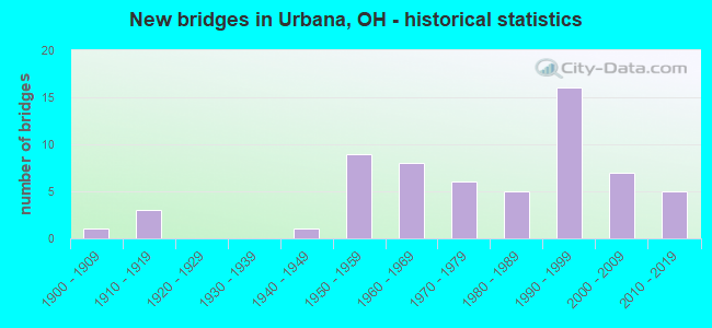
- New bridges - historical statistics
- 11900-1909
- 31910-1919
- 11940-1949
- 91950-1959
- 81960-1969
- 61970-1979
- 51980-1989
- 161990-1999
- 72000-2009
- 52010-2019

- Reconstructed bridges - Historical Statistics
- 31970-1979
- 01980-1989
- 21990-1999
- 12000-2009
- 22010-2019


- Bridge Condition - Deck
- 18.5%Excellent
- 38.9%Very good
- 29.6%Good
- 9.3%Satisfactory
- 3.7%Fair

- Bridge Condition - Superstructure
- 22.2%Excellent
- 31.5%Very good
- 31.5%Good
- 7.4%Satisfactory
- 3.7%Fair
- 3.7%Poor

- Bridge Condition - Substructure
- 16.7%Excellent
- 33.3%Very good
- 37.0%Good
- 9.3%Satisfactory
- 3.7%Fair

- Bridge Condition - Channel
- 24.6%Excellent
- 42.1%Very good
- 21.1%Good
- 10.5%Satisfactory
- 1.8%Fair

- Bridge Condition - Culverts
- 28.6%Excellent
- 42.9%Very good
- 28.6%Good
Find on map >> Show street view
Structure Number: 1100491, Location: .04MI.N. OF JCT. SR-296 (Lat: 40.155169, Lng: -83.788500), Route carried "on" structure: State highway 29, Year Built: 2007, Status: Open, Structure Length: 3.41m (11.19ft), Average Daily Traffic: 1,589 (year 2015), Truck Traffic: 5%, Average Future Daily Traffic: 2,206 (year 2035), Design Load: HS 25 or greater, Features Intersected: MAD RIVER
Minimum Vertical Clearance: 30+ m (98+ ft), Kilometerpoint: 25.251, Lanes on structure: 2, Owner: State Highway Agency, Approaching Roadway Width: 12.2m (40.0ft), Skew: 2 degrees, Material/Design: Concrete continuous, Design/Construction: Slab, Number Of Spans In Main Unit: 3, Length of Maximum Span: 13.0m (42.7ft), Curb-To-Curb Width: 12.2m (40.0ft), Out-to-Out Width: 12.2m (40.0ft)
Condition: Deck: Very good, Superstructure: Very good, Substructure: Satisfactory, Channel: Excellent, Operating Rating: 42.1 metric tons, Method Used To Determine Operating Rating: Load Factor (LF) rating reported by rating factor (RF) method using MS18 loading, Inventory Rating: 32.4 metric tons, Method Used To Determine Inventory Rating: Load Factor (LF) rating reported by rating factor (RF) method using MS18 loading, Structural Evaluation: Equal to present minimum criteria, Deck Geometry: Better than present minimum criteria, Waterway Adequacy: Equal to present minimum criteria, Approach Roadway Alignment: Better than present minimum criteria, Designated Inspection Frequency: Every 12 months, Inspection Date: January 2022, Deck Structure Type: Concrete Cast-file-Place, Wearing Surface/Protective System: Wearing Surface: Monolithic Concrete, Deck Protection: Epoxy Coated Reinforcing
Find on map >> Show street view
Structure Number: 1100521, Location: 2.36MI. W. OF JCT. SR-161 (Lat: 40.086069, Lng: -83.680150), Route carried "on" structure: State highway 29, Year Built: 1997, Status: Open, Structure Length: 1.55m (5.09ft), Average Daily Traffic: 5,489 (year 2015), Truck Traffic: 5%, Average Future Daily Traffic: 7,619 (year 2035), Design Load: HS 20+Mod, Features Intersected: DUGAN DITCH
Minimum Vertical Clearance: 30+ m (98+ ft), Kilometerpoint: 39.123, Lanes on structure: 2, Base Highway Network: Yes, Owner: State Highway Agency, Approaching Roadway Width: 9.1m (29.9ft), Material/Design: Prestressed concrete, Design/Construction: Box Beam or Girders - Multiple, Number Of Spans In Main Unit: 1, Length of Maximum Span: 14.8m (48.6ft), Curb-To-Curb Width: 13.4m (44.0ft), Out-to-Out Width: 13.4m (44.0ft)
Condition: Deck: Good, Superstructure: Good, Substructure: Good, Channel: Excellent, Operating Rating: 42.1 metric tons, Method Used To Determine Operating Rating: Load Factor (LF) rating reported by rating factor (RF) method using MS18 loading, Inventory Rating: 32.4 metric tons, Method Used To Determine Inventory Rating: Load Factor (LF) rating reported by rating factor (RF) method using MS18 loading, Structural Evaluation: Better than present minimum criteria, Deck Geometry: Equal to present minimum criteria, Waterway Adequacy: Equal to present desirable criteria, Approach Roadway Alignment: Equal to present desirable criteria, Designated Inspection Frequency: Every 24 months, Inspection Date: Febuary 2022, Deck Structure Type: Concrete Cast-file-Place, Wearing Surface/Protective System: Wearing Surface: Bituminous, Membrane: Preformed Fabric, Deck Protection: Epoxy Coated Reinforcing
Find on map >> Show street view
Structure Number: 1100734, Location: .7MI.E. OF JCT. SR-560 (Lat: 40.108781, Lng: -83.824269), Route carried "on" structure: US 36, Year Built: 1984, Status: Open, Structure Length: 2.74m (8.99ft), Average Daily Traffic: 5,847 (year 2015), Truck Traffic: 7%, Average Future Daily Traffic: 8,116 (year 2035), Design Load: HS 20, Features Intersected: ANDERSON CREEK
Minimum Vertical Clearance: 30+ m (98+ ft), Kilometerpoint: 17.896, Lanes on structure: 2, Base Highway Network: Yes, Owner: State Highway Agency, Approaching Roadway Width: 9.8m (32.2ft), Material/Design: Concrete continuous, Design/Construction: Slab, Number Of Spans In Main Unit: 3, Length of Maximum Span: 9.4m (30.8ft), Curb-To-Curb Width: 12.2m (40.0ft), Out-to-Out Width: 12.2m (40.0ft)
Condition: Deck: Good, Superstructure: Good, Substructure: Good, Channel: Good, Operating Rating: 42.1 metric tons, Method Used To Determine Operating Rating: Load Factor (LF) rating reported by rating factor (RF) method using MS18 loading, Inventory Rating: 32.4 metric tons, Method Used To Determine Inventory Rating: Load Factor (LF) rating reported by rating factor (RF) method using MS18 loading, Structural Evaluation: Better than present minimum criteria, Deck Geometry: Somewhat better than minimum adequacy, Waterway Adequacy: Equal to present desirable criteria, Approach Roadway Alignment: Better than present minimum criteria, Designated Inspection Frequency: Every 24 months, Inspection Date: January 2021, Deck Structure Type: Concrete Cast-file-Place, Wearing Surface/Protective System: Wearing Surface: Bituminous
Find on map >> Show street view
Structure Number: 1100742, Location: 2.02MI.E. OF JCT. SR-560 (Lat: 40.107361, Lng: -83.799531), Route carried "on" structure: US 36, Year Built: 1994, Status: Open, Structure Length: 5.52m (18.11ft), Average Daily Traffic: 5,847 (year 2015), Truck Traffic: 7%, Average Future Daily Traffic: 8,116 (year 2035), Design Load: HS 20+Mod, Features Intersected: MAD RIVER
Minimum Vertical Clearance: 30+ m (98+ ft), Kilometerpoint: 20.020, Lanes on structure: 2, Base Highway Network: Yes, Owner: State Highway Agency, Approaching Roadway Width: 13.4m (44.0ft), Material/Design: Prestressed concrete continuous, Design/Construction: Box Beam or Girders - Multiple, Number Of Spans In Main Unit: 3, Length of Maximum Span: 21.0m (68.9ft), Curb-To-Curb Width: 13.4m (44.0ft), Out-to-Out Width: 13.4m (44.0ft)
Condition: Deck: Very good, Superstructure: Very good, Substructure: Very good, Channel: Good, Operating Rating: 71.3 metric tons, Method Used To Determine Operating Rating: Load Factor (LF) rating reported by rating factor (RF) method using MS18 loading, Inventory Rating: 35.6 metric tons, Method Used To Determine Inventory Rating: Load Factor (LF) rating reported by rating factor (RF) method using MS18 loading, Structural Evaluation: Equal to present desirable criteria, Deck Geometry: Equal to present minimum criteria, Waterway Adequacy: Superior to present desirable criteria, Approach Roadway Alignment: Equal to present desirable criteria, Designated Inspection Frequency: Every 24 months, Inspection Date: January 2021, Deck Structure Type: Concrete Cast-file-Place, Wearing Surface/Protective System: Wearing Surface: Bituminous, Membrane: Preformed Fabric
Find on map >> Show street view
Structure Number: 1100793, Location: .41MI. W. OF JCT. USR-68 (Lat: 40.108561, Lng: -83.760019), Route carried "on" structure: US 36, Year Built: 1993, Status: Open, Structure Length: 0.85m (2.79ft), Average Daily Traffic: 9,738 (year 2015), Truck Traffic: 6%, Average Future Daily Traffic: 13,516 (year 2035), Design Load: HS 20+Mod, Features Intersected: DUGAN RUN
Minimum Vertical Clearance: 30+ m (98+ ft), Kilometerpoint: 23.464, Lanes on structure: 4, Base Highway Network: Yes, Owner: State Highway Agency, Approaching Roadway Width: 15.2m (49.9ft), Skew: 1 degrees, Material/Design: Concrete, Design/Construction: Slab, Number Of Spans In Main Unit: 1, Length of Maximum Span: 7.9m (25.9ft), Curb or Sidewalk Widths: Left: 2.4m (7.9ft), Right: 2.4m (7.9ft), Curb-To-Curb Width: 15.2m (49.9ft), Out-to-Out Width: 20.4m (66.9ft)
Condition: Deck: Good, Superstructure: Good, Substructure: Good, Channel: Good, Operating Rating: 42.1 metric tons, Method Used To Determine Operating Rating: Load Factor (LF) rating reported by rating factor (RF) method using MS18 loading, Inventory Rating: 32.4 metric tons, Method Used To Determine Inventory Rating: Load Factor (LF) rating reported by rating factor (RF) method using MS18 loading, Structural Evaluation: Better than present minimum criteria, Deck Geometry: High priority of corrective action, Waterway Adequacy: Superior to present desirable criteria, Approach Roadway Alignment: Equal to present desirable criteria, Designated Inspection Frequency: Every 24 months, Inspection Date: January 2021, Deck Structure Type: Concrete Cast-file-Place, Wearing Surface/Protective System: Wearing Surface: Monolithic Concrete, Deck Protection: Epoxy Coated Reinforcing
Find on map >> Show street view
Structure Number: 1100858, Location: .12 MI. W. OF JCT. USR68 (Lat: 40.108200, Lng: -83.754719), Route carried "on" structure: US 36, Year Built: 1900, Year Reconstructed: 1997, Status: Open, Structure Length: 0.76m (2.49ft), Average Daily Traffic: 9,738 (year 2015), Truck Traffic: 6%, Average Future Daily Traffic: 13,516 (year 2035), Design Load: HS 20+Mod, Features Intersected: UNNAMED DITCH
Minimum Vertical Clearance: 30+ m (98+ ft), Kilometerpoint: 23.931, Lanes on structure: 2, Base Highway Network: Yes, Owner: State Highway Agency, Approaching Roadway Width: 15.2m (49.9ft), Skew: 4 degrees, Material/Design: Aluminum, Iron, Design/Construction: Culvert, Number Of Spans In Main Unit: 1, Length of Maximum Span: 6.1m (20.0ft)
Condition: Channel: Excellent, Culverts: Very good, Operating Rating: 42.1 metric tons, Method Used To Determine Operating Rating: Load Factor (LF) rating reported by rating factor (RF) method using MS18 loading, Inventory Rating: 32.4 metric tons, Method Used To Determine Inventory Rating: Load Factor (LF) rating reported by rating factor (RF) method using MS18 loading, Structural Evaluation: Equal to present desirable criteria, Waterway Adequacy: Superior to present desirable criteria, Approach Roadway Alignment: Equal to present minimum criteria, Designated Inspection Frequency: Every 24 months, Inspection Date: April 2021
Find on map >> Show street view
Structure Number: 1101323, Location: 2.49MI.N. OF JCT. SR-4 (Lat: 40.041461, Lng: -83.689911), Route carried "on" structure: State highway 54, Year Built: 1966, Status: Open, Structure Length: 2.47m (8.10ft), Average Daily Traffic: 269 (year 2015), Truck Traffic: 4%, Average Future Daily Traffic: 373 (year 2035), Design Load: H 15, Features Intersected: DUGAN DITCH
Minimum Vertical Clearance: 30+ m (98+ ft), Kilometerpoint: 6.775, Lanes on structure: 2, Owner: State Highway Agency, Approaching Roadway Width: 11.0m (36.1ft), Material/Design: Concrete continuous, Design/Construction: Slab, Number Of Spans In Main Unit: 3, Length of Maximum Span: 9.1m (29.9ft), Curb-To-Curb Width: 11.0m (36.1ft), Out-to-Out Width: 11.0m (36.1ft)
Condition: Deck: Satisfactory, Superstructure: Satisfactory, Substructure: Satisfactory, Channel: Very good, Operating Rating: 22.7 metric tons, Method Used To Determine Operating Rating: Load Factor (LF) rating reported by rating factor (RF) method using MS18 loading, Inventory Rating: 16.2 metric tons, Method Used To Determine Inventory Rating: Load Factor (LF) rating reported by rating factor (RF) method using MS18 loading, Structural Evaluation: Somewhat better than minimum adequacy, Deck Geometry: Equal to present desirable criteria, Waterway Adequacy: Better than present minimum criteria, Approach Roadway Alignment: Better than present minimum criteria, Designated Inspection Frequency: Every 12 months, Inspection Date: January 2022, Deck Structure Type: Concrete Cast-file-Place, Wearing Surface/Protective System: Wearing Surface: Bituminous
Find on map >> Show street view
Structure Number: 1101331, Location: 3.44MI.N.OF JCT. SR-4 (Lat: 40.049561, Lng: -83.697431), Route carried "on" structure: State highway 54, Year Built: 1988, Status: Open, Structure Length: 2.10m (6.89ft), Average Daily Traffic: 269 (year 2015), Truck Traffic: 3%, Average Future Daily Traffic: 373 (year 2035), Design Load: HS 20+Mod, Features Intersected: DUGAN RUN
Minimum Vertical Clearance: 30+ m (98+ ft), Kilometerpoint: 8.304, Lanes on structure: 2, Owner: State Highway Agency, Approaching Roadway Width: 9.8m (32.2ft), Material/Design: Prestressed concrete, Design/Construction: Box Beam or Girders - Multiple, Number Of Spans In Main Unit: 1, Length of Maximum Span: 19.8m (65.0ft), Curb-To-Curb Width: 9.8m (32.2ft), Out-to-Out Width: 9.8m (32.2ft)
Condition: Deck: Good, Superstructure: Good, Substructure: Very good, Channel: Very good, Operating Rating: 42.1 metric tons, Method Used To Determine Operating Rating: Load Factor (LF) rating reported by rating factor (RF) method using MS18 loading, Inventory Rating: 32.4 metric tons, Method Used To Determine Inventory Rating: Load Factor (LF) rating reported by rating factor (RF) method using MS18 loading, Structural Evaluation: Better than present minimum criteria, Deck Geometry: Better than present minimum criteria, Waterway Adequacy: Equal to present desirable criteria, Approach Roadway Alignment: Equal to present desirable criteria, Designated Inspection Frequency: Every 24 months, Inspection Date: January 2021, Deck Structure Type: Concrete Cast-file-Place, Wearing Surface/Protective System: Wearing Surface: Bituminous
Find on map >> Show street view
Structure Number: 1101595, Location: 1.13MI.E. OF JCT. SR-560 (Lat: 40.068189, Lng: -83.810639), Route carried "on" structure: State highway 55, Year Built: 1958, Year Reconstructed: 2000, Status: Open, Structure Length: 5.33m (17.49ft), Average Daily Traffic: 1,467 (year 2015), Truck Traffic: 2%, Average Future Daily Traffic: 2,036 (year 2035), Design Load: HS 20+Mod, Features Intersected: MAD RIVER
Minimum Vertical Clearance: 30+ m (98+ ft), Kilometerpoint: 20.648, Lanes on structure: 2, Owner: State Highway Agency, Approaching Roadway Width: 13.4m (44.0ft), Skew: 1 degrees, Material/Design: Steel continuous, Design/Construction: Stringer/Multi-beam, Number Of Spans In Main Unit: 3, Length of Maximum Span: 19.8m (65.0ft), Curb-To-Curb Width: 13.4m (44.0ft), Out-to-Out Width: 13.4m (44.0ft)
Condition: Deck: Very good, Superstructure: Excellent, Substructure: Very good, Channel: Very good, Operating Rating: 42.1 metric tons, Method Used To Determine Operating Rating: Allowable Stress (AS) rating reported by rating factor (RF) method using MS18 loading, Inventory Rating: 32.4 metric tons, Method Used To Determine Inventory Rating: Allowable Stress (AS) rating reported by rating factor (RF) method using MS18 loading, Structural Evaluation: Equal to present desirable criteria, Deck Geometry: Equal to present desirable criteria, Waterway Adequacy: Better than present minimum criteria, Approach Roadway Alignment: Better than present minimum criteria, Designated Inspection Frequency: Every 24 months, Inspection Date: January 2021, Deck Structure Type: Concrete Cast-file-Place, Wearing Surface/Protective System: Wearing Surface: Monolithic Concrete, Deck Protection: Epoxy Coated Reinforcing
Find on map >> Show street view
Structure Number: 1101641, Location: 1.29 MI W OF JCT. USR68 (Lat: 40.091411, Lng: -83.777900), Route carried "on" structure: State highway 55, Year Built: 1990, Status: Open, Structure Length: 5.36m (17.59ft), Average Daily Traffic: 1,467 (year 2015), Truck Traffic: 2%, Average Future Daily Traffic: 2,036 (year 2035), Design Load: HS 20+Mod, Features Intersected: CONRAIL RAILROAD
Minimum Vertical Clearance: 30+ m (98+ ft), Kilometerpoint: 24.639, Lanes on structure: 2, Owner: State Highway Agency, Approaching Roadway Width: 9.8m (32.2ft), Material/Design: Prestressed concrete continuous, Design/Construction: Stringer/Multi-beam, Number Of Spans In Main Unit: 3, Length of Maximum Span: 17.4m (57.1ft), Curb-To-Curb Width: 9.1m (29.9ft), Out-to-Out Width: 10.2m (33.5ft)
Condition: Deck: Good, Superstructure: Very good, Substructure: Good, Operating Rating: 42.1 metric tons, Method Used To Determine Operating Rating: Load Factor (LF) rating reported by rating factor (RF) method using MS18 loading, Inventory Rating: 32.4 metric tons, Method Used To Determine Inventory Rating: Load Factor (LF) rating reported by rating factor (RF) method using MS18 loading, Structural Evaluation: Better than present minimum criteria, Deck Geometry: Somewhat better than minimum adequacy, Underclear: Equal to present desirable criteria, Approach Roadway Alignment: Equal to present desirable criteria, Designated Inspection Frequency: Every 24 months, Inspection Date: January 2021, Deck Structure Type: Concrete Cast-file-Place, Wearing Surface/Protective System: Wearing Surface: Monolithic Concrete, Deck Protection: Epoxy Coated Reinforcing
Find on map >> Show street view
Structure Number: 1101773, Location: .66 MILE N. OF CLA CO. LI (Lat: 40.034481, Lng: -83.796589), Route carried "on" structure: US 68, Year Built: 1999, Status: Open, Structure Length: 5.29m (17.36ft), Average Daily Traffic: 7,375 (year 2015), Truck Traffic: 9%, Average Future Daily Traffic: 10,237 (year 2035), Design Load: HS 20+Mod, Features Intersected: I&O RR & BIKEPATH
Minimum Vertical Clearance: 30+ m (98+ ft), Kilometerpoint: 1.062, Lanes on structure: 2, Base Highway Network: Yes, Owner: State Highway Agency, Approaching Roadway Width: 13.5m (44.3ft), Skew: 3 degrees, Material/Design: Prestressed concrete continuous, Design/Construction: Stringer/Multi-beam, Number Of Spans In Main Unit: 2, Length of Maximum Span: 25.5m (83.7ft), Curb-To-Curb Width: 12.6m (41.3ft), Out-to-Out Width: 13.5m (44.3ft)
Condition: Deck: Very good, Superstructure: Very good, Substructure: Good, Operating Rating: 71.3 metric tons, Method Used To Determine Operating Rating: Load Factor (LF) rating reported by rating factor (RF) method using MS18 loading, Inventory Rating: 32.4 metric tons, Method Used To Determine Inventory Rating: Load Factor (LF) rating reported by rating factor (RF) method using MS18 loading, Structural Evaluation: Better than present minimum criteria, Deck Geometry: Better than present minimum criteria, Underclear: Better than present minimum criteria, Approach Roadway Alignment: Equal to present desirable criteria, Designated Inspection Frequency: Every 24 months, Inspection Date: Febuary 2022, Deck Structure Type: Concrete Cast-file-Place, Wearing Surface/Protective System: Wearing Surface: Monolithic Concrete, Deck Protection: Epoxy Coated Reinforcing
Find on map >> Show street view
Structure Number: 1101803, Location: .66 MI. N.CLARK CO. LINE (Lat: 40.034211, Lng: -83.796661), Route carried "on" structure: US 68, Year Built: 1999, Status: Open, Structure Length: 5.29m (17.36ft), Average Daily Traffic: 7,375 (year 2015), Truck Traffic: 9%, Average Future Daily Traffic: 10,237 (year 2035), Design Load: HS 20+Mod, Features Intersected: I&O RR & BIKEPATH
Minimum Vertical Clearance: 30+ m (98+ ft), Kilometerpoint: 1.062, Lanes on structure: 2, Base Highway Network: Yes, Owner: State Highway Agency, Approaching Roadway Width: 13.5m (44.3ft), Skew: 3 degrees, Material/Design: Prestressed concrete continuous, Design/Construction: Stringer/Multi-beam, Number Of Spans In Main Unit: 2, Length of Maximum Span: 25.5m (83.7ft), Curb-To-Curb Width: 12.6m (41.3ft), Out-to-Out Width: 13.5m (44.3ft)
Condition: Deck: Very good, Superstructure: Very good, Substructure: Good, Operating Rating: 71.3 metric tons, Method Used To Determine Operating Rating: Load Factor (LF) rating reported by rating factor (RF) method using MS18 loading, Inventory Rating: 32.4 metric tons, Method Used To Determine Inventory Rating: Load Factor (LF) rating reported by rating factor (RF) method using MS18 loading, Structural Evaluation: Better than present minimum criteria, Deck Geometry: Better than present minimum criteria, Underclear: Better than present minimum criteria, Approach Roadway Alignment: Equal to present desirable criteria, Designated Inspection Frequency: Every 24 months, Inspection Date: Febuary 2022, Deck Structure Type: Concrete Cast-file-Place, Wearing Surface/Protective System: Wearing Surface: Monolithic Concrete, Deck Protection: Epoxy Coated Reinforcing
Find on map >> Show street view
Structure Number: 1101838, Location: 1.19 MI N. CLARK CO. LINE (Lat: 40.037500, Lng: -83.787281), Route carried "on" structure: US 68, Year Built: 1999, Status: Open, Structure Length: 2.23m (7.32ft), Average Daily Traffic: 7,375 (year 2015), Truck Traffic: 9%, Average Future Daily Traffic: 10,237 (year 2035), Design Load: HS 20+Mod, Features Intersected: MOORE'S RUN
Minimum Vertical Clearance: 30+ m (98+ ft), Kilometerpoint: 1.915, Lanes on structure: 2, Base Highway Network: Yes, Owner: State Highway Agency, Approaching Roadway Width: 12.6m (41.3ft), Skew: 4 degrees, Material/Design: Concrete continuous, Design/Construction: Slab, Number Of Spans In Main Unit: 3, Length of Maximum Span: 8.4m (27.6ft), Curb-To-Curb Width: 12.6m (41.3ft), Out-to-Out Width: 13.5m (44.3ft)
Condition: Deck: Very good, Superstructure: Very good, Substructure: Very good, Channel: Very good, Operating Rating: 42.1 metric tons, Method Used To Determine Operating Rating: Load Factor (LF) rating reported by rating factor (RF) method using MS18 loading, Inventory Rating: 32.4 metric tons, Method Used To Determine Inventory Rating: Load Factor (LF) rating reported by rating factor (RF) method using MS18 loading, Structural Evaluation: Equal to present desirable criteria, Deck Geometry: Better than present minimum criteria, Waterway Adequacy: Equal to present desirable criteria, Approach Roadway Alignment: Equal to present desirable criteria, Designated Inspection Frequency: Every 24 months, Inspection Date: Febuary 2022, Deck Structure Type: Concrete Cast-file-Place, Wearing Surface/Protective System: Wearing Surface: Monolithic Concrete, Deck Protection: Epoxy Coated Reinforcing
Find on map >> Show street view
Structure Number: 1101846, Location: 1.19 MI N. CLARK CO. LINE (Lat: 40.037219, Lng: -83.787389), Route carried "on" structure: US 68, Year Built: 1999, Status: Open, Structure Length: 2.23m (7.32ft), Average Daily Traffic: 7,375 (year 2015), Truck Traffic: 9%, Average Future Daily Traffic: 10,237 (year 2035), Design Load: HS 20+Mod, Features Intersected: MOORE'S RUN
Minimum Vertical Clearance: 30+ m (98+ ft), Kilometerpoint: 1.915, Lanes on structure: 2, Base Highway Network: Yes, Owner: State Highway Agency, Approaching Roadway Width: 12.6m (41.3ft), Skew: 4 degrees, Material/Design: Concrete continuous, Design/Construction: Slab, Number Of Spans In Main Unit: 3, Length of Maximum Span: 8.4m (27.6ft), Curb-To-Curb Width: 12.6m (41.3ft), Out-to-Out Width: 13.5m (44.3ft)
Condition: Deck: Very good, Superstructure: Very good, Substructure: Very good, Channel: Very good, Operating Rating: 42.1 metric tons, Method Used To Determine Operating Rating: Load Factor (LF) rating reported by rating factor (RF) method using MS18 loading, Inventory Rating: 32.4 metric tons, Method Used To Determine Inventory Rating: Load Factor (LF) rating reported by rating factor (RF) method using MS18 loading, Structural Evaluation: Equal to present desirable criteria, Deck Geometry: Better than present minimum criteria, Waterway Adequacy: Equal to present desirable criteria, Approach Roadway Alignment: Equal to present desirable criteria, Designated Inspection Frequency: Every 24 months, Inspection Date: Febuary 2022, Deck Structure Type: Concrete Cast-file-Place, Wearing Surface/Protective System: Wearing Surface: Monolithic Concrete, Deck Protection: Epoxy Coated Reinforcing
Find on map >> Show street view
Structure Number: 1101889, Location: 1.26MI.S. OF JCT.SR-55 (Lat: 40.076669, Lng: -83.764850), Route carried "on" structure: US 68, Year Built: 1987, Status: Open, Structure Length: 0.73m (2.40ft), Average Daily Traffic: 14,750 (year 2015), Truck Traffic: 8%, Average Future Daily Traffic: 20,473 (year 2035), Design Load: HS 20, Features Intersected: BOGLES RUN
Minimum Vertical Clearance: 30+ m (98+ ft), Kilometerpoint: 7.902, Lanes on structure: 2, Base Highway Network: Yes, Owner: State Highway Agency, Approaching Roadway Width: 12.2m (40.0ft), Skew: 1 degrees, Material/Design: Concrete, Design/Construction: Culvert, Number Of Spans In Main Unit: 2, Length of Maximum Span: 3.0m (9.8ft)
Condition: Channel: Satisfactory, Culverts: Very good, Operating Rating: 42.1 metric tons, Method Used To Determine Operating Rating: Load Factor (LF) rating reported by rating factor (RF) method using MS18 loading, Inventory Rating: 32.4 metric tons, Method Used To Determine Inventory Rating: Load Factor (LF) rating reported by rating factor (RF) method using MS18 loading, Structural Evaluation: Equal to present desirable criteria, Waterway Adequacy: Superior to present desirable criteria, Approach Roadway Alignment: Superior to present desirable criteria, Designated Inspection Frequency: Every 24 months, Inspection Date: January 2021
Find on map >> Show street view
Structure Number: 1101943, Location: .23MI. N. OF JCT. SR-296 (Lat: 40.158569, Lng: -83.745519), Route carried "on" structure: US 68, Year Built: 1983, Status: Open, Structure Length: 3.11m (10.20ft), Average Daily Traffic: 7,097 (year 2015), Truck Traffic: 12%, Average Future Daily Traffic: 9,851 (year 2035), Design Load: HS 20+Mod, Features Intersected: KINGS CREEK
Minimum Vertical Clearance: 30+ m (98+ ft), Kilometerpoint: 17.268, Lanes on structure: 2, Base Highway Network: Yes, Owner: State Highway Agency, Approaching Roadway Width: 12.2m (40.0ft), Skew: 2 degrees, Material/Design: Concrete continuous, Design/Construction: Slab, Number Of Spans In Main Unit: 3, Length of Maximum Span: 11.6m (38.1ft), Curb-To-Curb Width: 12.2m (40.0ft), Out-to-Out Width: 12.2m (40.0ft)
Condition: Deck: Good, Superstructure: Good, Substructure: Good, Channel: Very good, Operating Rating: 64.8 metric tons, Method Used To Determine Operating Rating: Load Factor (LF) rating reported by rating factor (RF) method using MS18 loading, Inventory Rating: 38.9 metric tons, Method Used To Determine Inventory Rating: Load Factor (LF) rating reported by rating factor (RF) method using MS18 loading, Structural Evaluation: Better than present minimum criteria, Deck Geometry: Somewhat better than minimum adequacy, Waterway Adequacy: Superior to present desirable criteria, Approach Roadway Alignment: Superior to present desirable criteria, Designated Inspection Frequency: Every 24 months, Inspection Date: Febuary 2022, Deck Structure Type: Concrete Cast-file-Place, Wearing Surface/Protective System: Wearing Surface: Bituminous, Membrane: Preformed Fabric, Deck Protection: Epoxy Coated Reinforcing
Find on map >> Show street view
Structure Number: 1101994, Location: .43MI.N. OF JCT. SR-296 (Lat: 40.161331, Lng: -83.745250), Route carried "on" structure: US 68, Year Built: 1985, Status: Open, Structure Length: 0.85m (2.79ft), Average Daily Traffic: 7,097 (year 2015), Truck Traffic: 12%, Average Future Daily Traffic: 9,851 (year 2035), Design Load: HS 20+Mod, Features Intersected: TRIB OF KINGS CREEK
Minimum Vertical Clearance: 30+ m (98+ ft), Kilometerpoint: 17.590, Lanes on structure: 2, Base Highway Network: Yes, Owner: State Highway Agency, Approaching Roadway Width: 11.6m (38.1ft), Material/Design: Concrete, Design/Construction: Culvert, Number Of Spans In Main Unit: 2, Length of Maximum Span: 3.7m (12.1ft)
Condition: Channel: Good, Culverts: Good, Operating Rating: 42.1 metric tons, Method Used To Determine Operating Rating: Load Factor (LF) rating reported by rating factor (RF) method using MS18 loading, Inventory Rating: 29.2 metric tons, Method Used To Determine Inventory Rating: Load Factor (LF) rating reported by rating factor (RF) method using MS18 loading, Structural Evaluation: Better than present minimum criteria, Waterway Adequacy: Superior to present desirable criteria, Approach Roadway Alignment: Equal to present desirable criteria, Designated Inspection Frequency: Every 24 months, Inspection Date: Febuary 2022
Find on map >> Show street view
Structure Number: 1102613, Location: .21MI.E. OF JCT. SR-29 (Lat: 40.156881, Lng: -83.785569), Route carried "on" structure: State highway 296, Year Built: 1960, Status: Open, Structure Length: 3.87m (12.70ft), Average Daily Traffic: 1,049 (year 2015), Truck Traffic: 4%, Average Future Daily Traffic: 1,456 (year 2035), Design Load: H 15, Features Intersected: KINGS CREEK
Minimum Vertical Clearance: 30+ m (98+ ft), Kilometerpoint: 0.338, Lanes on structure: 2, Owner: State Highway Agency, Approaching Roadway Width: 11.0m (36.1ft), Skew: 3 degrees, Material/Design: Concrete continuous, Design/Construction: Slab, Number Of Spans In Main Unit: 3, Length of Maximum Span: 14.6m (47.9ft), Curb-To-Curb Width: 11.6m (38.1ft), Out-to-Out Width: 11.6m (38.1ft)
Condition: Deck: Satisfactory, Superstructure: Satisfactory, Substructure: Good, Channel: Good, Operating Rating: 35.6 metric tons, Method Used To Determine Operating Rating: Load and Resistance Factor Rating (LRFR) rating reported by rating factor(RF) method using HL-93 loadings, Inventory Rating: 29.2 metric tons, Method Used To Determine Inventory Rating: Load and Resistance Factor Rating (LRFR) rating reported by rating factor(RF) method using HL-93 loadings, Structural Evaluation: Equal to present minimum criteria, Deck Geometry: Equal to present minimum criteria, Waterway Adequacy: Better than present minimum criteria, Approach Roadway Alignment: Better than present minimum criteria, Designated Inspection Frequency: Every 12 months, Inspection Date: January 2022, Deck Structure Type: Concrete Cast-file-Place, Wearing Surface/Protective System: Wearing Surface: Bituminous
Find on map >> Show street view
Structure Number: 1102648, Location: 1.11MI.W. OF JCT. USR-68 (Lat: 40.156511, Lng: -83.766800), Route carried "on" structure: State highway 296, Year Built: 1960, Status: Open, Structure Length: 2.87m (9.42ft), Average Daily Traffic: 1,049 (year 2015), Truck Traffic: 4%, Average Future Daily Traffic: 1,456 (year 2035), Design Load: H 15, Features Intersected: KINGS CREEK TRIBUTARY
Minimum Vertical Clearance: 30+ m (98+ ft), Kilometerpoint: 1.963, Lanes on structure: 2, Owner: State Highway Agency, Approaching Roadway Width: 11.0m (36.1ft), Skew: 3 degrees, Material/Design: Concrete continuous, Design/Construction: Slab, Number Of Spans In Main Unit: 3, Length of Maximum Span: 10.7m (35.1ft), Curb-To-Curb Width: 11.0m (36.1ft), Out-to-Out Width: 11.0m (36.1ft)
Condition: Deck: Good, Superstructure: Good, Substructure: Good, Channel: Very good, Operating Rating: 32.4 metric tons, Method Used To Determine Operating Rating: Load and Resistance Factor Rating (LRFR) rating reported by rating factor(RF) method using HL-93 loadings, Inventory Rating: 25.9 metric tons, Method Used To Determine Inventory Rating: Load and Resistance Factor Rating (LRFR) rating reported by rating factor(RF) method using HL-93 loadings, Structural Evaluation: Equal to present minimum criteria, Deck Geometry: Equal to present minimum criteria, Waterway Adequacy: Better than present minimum criteria, Approach Roadway Alignment: Better than present minimum criteria, Designated Inspection Frequency: Every 24 months, Inspection Date: January 2022, Deck Structure Type: Concrete Cast-file-Place, Wearing Surface/Protective System: Wearing Surface: Bituminous
Find on map >> Show street view
Structure Number: 1102672, Location: .21MI.W. OF JCT. USR-68 (Lat: 40.155589, Lng: -83.749719), Route carried "on" structure: State highway 296, Year Built: 1960, Status: Open, Structure Length: 3.08m (10.10ft), Average Daily Traffic: 1,049 (year 2015), Truck Traffic: 4%, Average Future Daily Traffic: 1,456 (year 2035), Design Load: H 15, Features Intersected: KINGS CREEK
Minimum Vertical Clearance: 30+ m (98+ ft), Kilometerpoint: 3.412, Lanes on structure: 2, Owner: State Highway Agency, Approaching Roadway Width: 11.0m (36.1ft), Skew: 3 degrees, Material/Design: Concrete continuous, Design/Construction: Slab, Number Of Spans In Main Unit: 3, Length of Maximum Span: 11.6m (38.1ft), Curb-To-Curb Width: 11.0m (36.1ft), Out-to-Out Width: 11.0m (36.1ft)
Condition: Deck: Satisfactory, Superstructure: Satisfactory, Substructure: Good, Channel: Very good, Operating Rating: 42.1 metric tons, Method Used To Determine Operating Rating: Load Factor (LF) rating reported by rating factor (RF) method using MS18 loading, Inventory Rating: 29.2 metric tons, Method Used To Determine Inventory Rating: Load Factor (LF) rating reported by rating factor (RF) method using MS18 loading, Structural Evaluation: Equal to present minimum criteria, Deck Geometry: Equal to present minimum criteria, Waterway Adequacy: Better than present minimum criteria, Approach Roadway Alignment: Better than present minimum criteria, Designated Inspection Frequency: Every 12 months, Inspection Date: January 2022, Deck Structure Type: Concrete Cast-file-Place, Wearing Surface/Protective System: Wearing Surface: Bituminous
Find on map >> Show street view
Structure Number: 1103105, Location: .54MI.N. OF JCT. SR-55 (Lat: 40.077689, Lng: -83.834350), Route carried "on" structure: State highway 560, Year Built: 1979, Status: Open, Structure Length: 1.07m (3.51ft), Average Daily Traffic: 2,606 (year 2015), Truck Traffic: 6%, Average Future Daily Traffic: 3,617 (year 2035), Design Load: HS 20, Features Intersected: TRIB TO NETTLE CREEK
Minimum Vertical Clearance: 30+ m (98+ ft), Kilometerpoint: 0.869, Lanes on structure: 2, Owner: State Highway Agency, Approaching Roadway Width: 10.7m (35.1ft), Material/Design: Concrete, Design/Construction: Culvert, Number Of Spans In Main Unit: 3, Length of Maximum Span: 2.4m (7.9ft)
Condition: Channel: Satisfactory, Culverts: Good, Operating Rating: 42.1 metric tons, Method Used To Determine Operating Rating: Load Factor (LF) rating reported by rating factor (RF) method using MS18 loading, Inventory Rating: 32.4 metric tons, Method Used To Determine Inventory Rating: Load Factor (LF) rating reported by rating factor (RF) method using MS18 loading, Structural Evaluation: Better than present minimum criteria, Waterway Adequacy: Superior to present desirable criteria, Approach Roadway Alignment: Equal to present desirable criteria, Designated Inspection Frequency: Every 24 months, Inspection Date: January 2022
Find on map >> Show street view
Structure Number: 1103121, Location: 1.28MI.S. OF JCT. USR-36 (Lat: 40.091269, Lng: -83.837539), Route carried "on" structure: State highway 560, Year Built: 1958, Status: Open, Structure Length: 1.89m (6.20ft), Average Daily Traffic: 2,606 (year 2015), Truck Traffic: 6%, Average Future Daily Traffic: 3,617 (year 2035), Design Load: H 10, Features Intersected: OWENS CREEK
Minimum Vertical Clearance: 30+ m (98+ ft), Kilometerpoint: 2.382, Lanes on structure: 2, Owner: State Highway Agency, Approaching Roadway Width: 11.0m (36.1ft), Skew: 1 degrees, Material/Design: Concrete continuous, Design/Construction: Slab, Number Of Spans In Main Unit: 3, Length of Maximum Span: 7.0m (23.0ft), Curb-To-Curb Width: 11.0m (36.1ft), Out-to-Out Width: 11.0m (36.1ft)
Condition: Deck: Good, Superstructure: Good, Substructure: Good, Channel: Very good, Operating Rating: 35.6 metric tons, Method Used To Determine Operating Rating: Load Factor (LF) rating reported by rating factor (RF) method using MS18 loading, Inventory Rating: 19.4 metric tons, Method Used To Determine Inventory Rating: Load Factor (LF) rating reported by rating factor (RF) method using MS18 loading, Structural Evaluation: Somewhat better than minimum adequacy, Deck Geometry: Somewhat better than minimum adequacy, Waterway Adequacy: Equal to present minimum criteria, Approach Roadway Alignment: Better than present minimum criteria, Bridge Posting: Required (Relationship of Operating Rating to Maximum Legal Load: 10.0 - 19.9% below), Designated Inspection Frequency: Every 24 months, Inspection Date: January 2022, Deck Structure Type: Concrete Cast-file-Place, Wearing Surface/Protective System: Wearing Surface: Latex Concrete
Find on map >> Show street view
Structure Number: 1103156, Location: 1.2MI.S. OF JCT. USR-36 (Lat: 40.092411, Lng: -83.837681), Route carried "on" structure: State highway 560, Year Built: 1958, Status: Posted for load, Structure Length: 2.68m (8.79ft), Average Daily Traffic: 2,606 (year 2015), Truck Traffic: 6%, Average Future Daily Traffic: 3,617 (year 2035), Design Load: H 10, Features Intersected: NETTLE CREEK
Minimum Vertical Clearance: 30+ m (98+ ft), Kilometerpoint: 2.511, Lanes on structure: 2, Owner: State Highway Agency, Approaching Roadway Width: 11.0m (36.1ft), Material/Design: Concrete continuous, Design/Construction: Slab, Number Of Spans In Main Unit: 3, Length of Maximum Span: 10.1m (33.1ft), Curb-To-Curb Width: 11.0m (36.1ft), Out-to-Out Width: 11.0m (36.1ft)
Condition: Deck: Good, Superstructure: Good, Substructure: Good, Channel: Very good, Operating Rating: 32.4 metric tons, Method Used To Determine Operating Rating: Load Factor (LF) rating reported by rating factor (RF) method using MS18 loading, Inventory Rating: 19.4 metric tons, Method Used To Determine Inventory Rating: Load Factor (LF) rating reported by rating factor (RF) method using MS18 loading, Structural Evaluation: Somewhat better than minimum adequacy, Deck Geometry: Somewhat better than minimum adequacy, Waterway Adequacy: Better than present minimum criteria, Approach Roadway Alignment: Better than present minimum criteria, Bridge Posting: Required (Relationship of Operating Rating to Maximum Legal Load: 20.0 - 29.9% below), Designated Inspection Frequency: Every 12 months, Inspection Date: January 2022, Deck Structure Type: Concrete Cast-file-Place, Wearing Surface/Protective System: Wearing Surface: Latex Concrete
Find on map >> Show street view
Structure Number: 1103245, Location: .72MI.N. OF JCT. USR-36 (Lat: 40.119669, Lng: -83.836431), Route carried "on" structure: State highway 560, Year Built: 1958, Status: Posted for load, Structure Length: 1.68m (5.51ft), Average Daily Traffic: 1,368 (year 2015), Truck Traffic: 4%, Average Future Daily Traffic: 1,899 (year 2035), Design Load: H 10, Features Intersected: TRIB OF ANDERSON CREEK
Minimum Vertical Clearance: 30+ m (98+ ft), Kilometerpoint: 5.601, Lanes on structure: 2, Owner: State Highway Agency, Approaching Roadway Width: 11.0m (36.1ft), Skew: 1 degrees, Material/Design: Concrete continuous, Design/Construction: Slab, Number Of Spans In Main Unit: 3, Length of Maximum Span: 6.1m (20.0ft), Curb-To-Curb Width: 11.0m (36.1ft), Out-to-Out Width: 11.0m (36.1ft)
Condition: Deck: Good, Superstructure: Good, Substructure: Very good, Channel: Good, Operating Rating: 34.3 metric tons, Method Used To Determine Operating Rating: Load Factor (LF) rating reported by rating factor (RF) method using MS18 loading, Inventory Rating: 20.4 metric tons, Method Used To Determine Inventory Rating: Load Factor (LF) rating reported by rating factor (RF) method using MS18 loading, Structural Evaluation: Somewhat better than minimum adequacy, Deck Geometry: Equal to present minimum criteria, Waterway Adequacy: Somewhat better than minimum adequacy, Approach Roadway Alignment: Better than present minimum criteria, Bridge Posting: Required (Relationship of Operating Rating to Maximum Legal Load: 10.0 - 19.9% below), Designated Inspection Frequency: Every 12 months, Inspection Date: January 2022, Deck Structure Type: Concrete Cast-file-Place, Wearing Surface/Protective System: Wearing Surface: Integral Concrete
Find on map >> Show street view
Structure Number: 1103334, Location: 1.49MI.N. OF JCT. USR-36 (Lat: 40.130711, Lng: -83.835369), Route carried "on" structure: State highway 560, Year Built: 1958, Status: Open, Structure Length: 1.89m (6.20ft), Average Daily Traffic: 838 (year 2015), Truck Traffic: 4%, Average Future Daily Traffic: 1,163 (year 2035), Design Load: H 10, Features Intersected: RUSSELL CREEK
Minimum Vertical Clearance: 30+ m (98+ ft), Kilometerpoint: 6.840, Lanes on structure: 2, Owner: State Highway Agency, Approaching Roadway Width: 11.0m (36.1ft), Material/Design: Concrete continuous, Design/Construction: Slab, Number Of Spans In Main Unit: 3, Length of Maximum Span: 7.0m (23.0ft), Curb-To-Curb Width: 11.0m (36.1ft), Out-to-Out Width: 11.0m (36.1ft)
Condition: Deck: Good, Superstructure: Good, Substructure: Good, Channel: Very good, Operating Rating: 35.6 metric tons, Method Used To Determine Operating Rating: Load Factor (LF) rating reported by rating factor (RF) method using MS18 loading, Inventory Rating: 19.4 metric tons, Method Used To Determine Inventory Rating: Load Factor (LF) rating reported by rating factor (RF) method using MS18 loading, Structural Evaluation: Somewhat better than minimum adequacy, Deck Geometry: Better than present minimum criteria, Waterway Adequacy: Better than present minimum criteria, Approach Roadway Alignment: Better than present minimum criteria, Designated Inspection Frequency: Every 24 months, Inspection Date: January 2022, Deck Structure Type: Concrete Cast-file-Place, Wearing Surface/Protective System: Wearing Surface: Integral Concrete
Find on map >> Show street view
Structure Number: 1103369, Location: 2.65MI.N. OF JCT. USR-36 (Lat: 40.147569, Lng: -83.833989), Route carried "on" structure: State highway 560, Year Built: 1958, Status: Open, Structure Length: 2.47m (8.10ft), Average Daily Traffic: 893 (year 2015), Truck Traffic: 4%, Average Future Daily Traffic: 1,163 (year 2035), Design Load: H 10, Features Intersected: ANDERSON CREEK
Minimum Vertical Clearance: 30+ m (98+ ft), Kilometerpoint: 8.707, Lanes on structure: 2, Owner: State Highway Agency, Approaching Roadway Width: 11.0m (36.1ft), Skew: 2 degrees, Material/Design: Concrete continuous, Design/Construction: Slab, Number Of Spans In Main Unit: 3, Length of Maximum Span: 9.1m (29.9ft), Curb-To-Curb Width: 11.0m (36.1ft), Out-to-Out Width: 11.0m (36.1ft)
Condition: Deck: Fair, Superstructure: Fair, Substructure: Fair, Channel: Satisfactory, Operating Rating: 32.4 metric tons, Method Used To Determine Operating Rating: Load Factor (LF) rating reported by rating factor (RF) method using MS18 loading, Inventory Rating: 19.4 metric tons, Method Used To Determine Inventory Rating: Load Factor (LF) rating reported by rating factor (RF) method using MS18 loading, Structural Evaluation: Somewhat better than minimum adequacy, Deck Geometry: Better than present minimum criteria, Waterway Adequacy: Equal to present minimum criteria, Approach Roadway Alignment: Better than present minimum criteria, Bridge Posting: Required (Relationship of Operating Rating to Maximum Legal Load: 10.0 - 19.9% below), Designated Inspection Frequency: Every 12 months, Inspection Date: January 2022, Deck Structure Type: Concrete Cast-file-Place, Wearing Surface/Protective System: Wearing Surface: Latex Concrete
Find on map >> Show street view
Structure Number: 1103431, Location: .67 MI. N. OF JCT. USR-36 (Lat: 40.116789, Lng: -83.671139), Route carried "on" structure: State highway 814, Year Built: 1998, Status: Open, Structure Length: 1.01m (3.31ft), Average Daily Traffic: 2,648 (year 2015), Truck Traffic: 2%, Average Future Daily Traffic: 3,675 (year 2035), Design Load: HS 20+Mod, Features Intersected: DUGAN RUN
Minimum Vertical Clearance: 30+ m (98+ ft), Kilometerpoint: 1.078, Lanes on structure: 2, Owner: State Highway Agency, Approaching Roadway Width: 7.3m (24.0ft), Material/Design: Concrete, Design/Construction: Frame, Number Of Spans In Main Unit: 1, Length of Maximum Span: 9.1m (29.9ft), Curb-To-Curb Width: 20.9m (68.6ft), Out-to-Out Width: 20.9m (68.6ft)
Condition: Deck: Very good, Superstructure: Very good, Substructure: Very good, Channel: Satisfactory, Operating Rating: 42.1 metric tons, Method Used To Determine Operating Rating: Load Factor (LF) rating reported by rating factor (RF) method using MS18 loading, Inventory Rating: 32.4 metric tons, Method Used To Determine Inventory Rating: Load Factor (LF) rating reported by rating factor (RF) method using MS18 loading, Structural Evaluation: Equal to present desirable criteria, Deck Geometry: Superior to present desirable criteria, Waterway Adequacy: Superior to present desirable criteria, Approach Roadway Alignment: Equal to present desirable criteria, Designated Inspection Frequency: Every 24 months, Inspection Date: Febuary 2022, Deck Structure Type: Concrete Cast-file-Place, Wearing Surface/Protective System: Wearing Surface: Bituminous, Membrane: Preformed Fabric, Deck Protection: Epoxy Coated Reinforcing
Find on map >> Show street view
Structure Number: 1103466, Location: 1.26MI. N. OF JCT. USR-36 (Lat: 40.125161, Lng: -83.673819), Route carried "on" structure: State highway 814, Year Built: 1998, Status: Open, Structure Length: 0.68m (2.23ft), Average Daily Traffic: 2,648 (year 2015), Truck Traffic: 2%, Average Future Daily Traffic: 3,675 (year 2035), Design Load: HS 20+Mod, Features Intersected: TRIBUTARY OF DUGAN RUN
Minimum Vertical Clearance: 30+ m (98+ ft), Kilometerpoint: 2.028, Lanes on structure: 2, Owner: State Highway Agency, Approaching Roadway Width: 7.3m (24.0ft), Skew: 2 degrees, Material/Design: Concrete, Design/Construction: Culvert, Number Of Spans In Main Unit: 1, Length of Maximum Span: 6.2m (20.3ft)
Condition: Channel: Good, Culverts: Very good, Operating Rating: 55.1 metric tons, Method Used To Determine Operating Rating: Load Factor (LF) rating reported by rating factor (RF) method using MS18 loading, Inventory Rating: 32.4 metric tons, Method Used To Determine Inventory Rating: Load Factor (LF) rating reported by rating factor (RF) method using MS18 loading, Structural Evaluation: Equal to present desirable criteria, Waterway Adequacy: Superior to present desirable criteria, Approach Roadway Alignment: Equal to present desirable criteria, Designated Inspection Frequency: Every 24 months, Inspection Date: Febuary 2022, Wearing Surface/Protective System: Deck Protection: Epoxy Coated Reinforcing
Find on map >> Show street view
Structure Number: 1130072, Location: .04 MI. E. OF SR 560 (Lat: 40.084031, Lng: -83.836100), Route carried "on" structure: County highway C0193, Year Built: 1970, Status: Open, Structure Length: 3.17m (10.40ft), Average Daily Traffic: 364 (year 2015), Truck Traffic: 7%, Average Future Daily Traffic: 505 (year 2035), Design Load: HS 20, Features Intersected: NETTLE CREEK, Facility Carried by Structure: OLD TROY PIKE
Minimum Vertical Clearance: 30+ m (98+ ft), Kilometerpoint: 17.188, Lanes on structure: 2, Owner: County Highway Agency, Approaching Roadway Width: 6.1m (20.0ft), Material/Design: Prestressed concrete, Design/Construction: Box Beam or Girders - Multiple, Number Of Spans In Main Unit: 3, Length of Maximum Span: 30.5m (100.1ft), Curb-To-Curb Width: 7.3m (24.0ft), Out-to-Out Width: 7.3m (24.0ft)
Condition: Deck: Very good, Superstructure: Fair, Substructure: Very good, Channel: Very good, Operating Rating: 68.0 metric tons, Method Used To Determine Operating Rating: Load Factor (LF) rating reported by rating factor (RF) method using MS18 loading, Inventory Rating: 22.7 metric tons, Method Used To Determine Inventory Rating: Load Factor (LF) rating reported by rating factor (RF) method using MS18 loading, Structural Evaluation: Somewhat better than minimum adequacy, Deck Geometry: Somewhat better than minimum adequacy, Waterway Adequacy: Equal to present minimum criteria, Approach Roadway Alignment: Equal to present desirable criteria, Designated Inspection Frequency: Every 12 months, Inspection Date: November 2021, Deck Structure Type: Other, Wearing Surface/Protective System: Wearing Surface: Bituminous
Find on map >> Show street view
Structure Number: 113008, Location: .3 MI. E. OF BAIR RD (Lat: 40.086611, Lng: -83.816000), Route carried "on" structure: County highway C0193, Year Built: 1960, Status: Open, Structure Length: 2.07m (6.79ft), Average Daily Traffic: 319 (year 2015), Truck Traffic: 8%, Average Future Daily Traffic: 443 (year 2035), Design Load: H 15, Features Intersected: ANDERSON CREEK, Facility Carried by Structure: OLD TROY PIKE
Minimum Vertical Clearance: 30+ m (98+ ft), Kilometerpoint: 19.055, Lanes on structure: 2, Owner: County Highway Agency, Approaching Roadway Width: 5.5m (18.0ft), Skew: 1 degrees, Material/Design: Prestressed concrete, Design/Construction: Box Beam or Girders - Multiple, Number Of Spans In Main Unit: 2, Length of Maximum Span: 19.5m (64.0ft), Curb-To-Curb Width: 7.3m (24.0ft), Out-to-Out Width: 7.4m (24.3ft)
Condition: Deck: Very good, Superstructure: Good, Substructure: Good, Channel: Very good, Operating Rating: 68.0 metric tons, Method Used To Determine Operating Rating: Load Factor (LF) rating reported by rating factor (RF) method using MS18 loading, Inventory Rating: 42.1 metric tons, Method Used To Determine Inventory Rating: Load Factor (LF) rating reported by rating factor (RF) method using MS18 loading, Structural Evaluation: Better than present minimum criteria, Deck Geometry: Somewhat better than minimum adequacy, Waterway Adequacy: Equal to present minimum criteria, Approach Roadway Alignment: Equal to present desirable criteria, Designated Inspection Frequency: Every 24 months, Inspection Date: November 2021, Deck Structure Type: Other, Wearing Surface/Protective System: Wearing Surface: Bituminous
Find on map >> Show street view
Structure Number: 1130544, Location: .06 MI OF SR 560 (Lat: 40.131619, Lng: -83.836539), Route carried "on" structure: County highway C0016, Year Built: 1962, Status: Open, Structure Length: 1.59m (5.22ft), Average Daily Traffic: 365 (year 2015), Truck Traffic: 7%, Average Future Daily Traffic: 507 (year 2035), Design Load: HS 20, Features Intersected: RUSSELL CREEK, Facility Carried by Structure: MILLERSTOWN ROAD
Minimum Vertical Clearance: 30+ m (98+ ft), Kilometerpoint: 4.410, Lanes on structure: 2, Owner: County Highway Agency, Approaching Roadway Width: 6.1m (20.0ft), Skew: 4 degrees, Material/Design: Prestressed concrete, Design/Construction: Box Beam or Girders - Multiple, Number Of Spans In Main Unit: 1, Length of Maximum Span: 15.5m (50.9ft), Curb-To-Curb Width: 7.3m (24.0ft), Out-to-Out Width: 7.3m (24.0ft)
Condition: Deck: Very good, Superstructure: Very good, Substructure: Very good, Channel: Very good, Operating Rating: 97.2 metric tons, Method Used To Determine Operating Rating: Load Factor (LF) rating reported by rating factor (RF) method using MS18 loading, Inventory Rating: 58.3 metric tons, Method Used To Determine Inventory Rating: Load Factor (LF) rating reported by rating factor (RF) method using MS18 loading, Structural Evaluation: Equal to present desirable criteria, Deck Geometry: Somewhat better than minimum adequacy, Waterway Adequacy: Better than present minimum criteria, Approach Roadway Alignment: Equal to present desirable criteria, Designated Inspection Frequency: Every 24 months, Inspection Date: November 2020, Deck Structure Type: Other, Wearing Surface/Protective System: Wearing Surface: Bituminous
Find on map >> Show street view
Structure Number: 1130552, Location: .5 MI E OF SR 560 (Lat: 40.130950, Lng: -83.825750), Route carried "on" structure: County highway C0016, Year Built: 1910, Year Reconstructed: 1970, Status: Open, Structure Length: 0.79m (2.59ft), Average Daily Traffic: 522 (year 2015), Truck Traffic: 7%, Average Future Daily Traffic: 725 (year 2035), Design Load: HS 20, Features Intersected: BRANCH OF ANDERSON CREEK, Facility Carried by Structure: MILLERSTOWN ROAD
Minimum Vertical Clearance: 30+ m (98+ ft), Kilometerpoint: 5.343, Lanes on structure: 2, Owner: County Highway Agency, Approaching Roadway Width: 7.3m (24.0ft), Skew: 1 degrees, Material/Design: Prestressed concrete, Design/Construction: Box Beam or Girders - Multiple, Number Of Spans In Main Unit: 1, Length of Maximum Span: 7.6m (24.9ft), Curb-To-Curb Width: 8.5m (27.9ft), Out-to-Out Width: 9.1m (29.9ft)
Condition: Deck: Very good, Superstructure: Very good, Substructure: Very good, Channel: Very good, Operating Rating: 87.5 metric tons, Method Used To Determine Operating Rating: Load Factor (LF) rating reported by rating factor (RF) method using MS18 loading, Inventory Rating: 51.8 metric tons, Method Used To Determine Inventory Rating: Load Factor (LF) rating reported by rating factor (RF) method using MS18 loading, Structural Evaluation: Equal to present desirable criteria, Deck Geometry: Somewhat better than minimum adequacy, Waterway Adequacy: Better than present minimum criteria, Approach Roadway Alignment: Equal to present desirable criteria, Designated Inspection Frequency: Every 24 months, Inspection Date: November 2020, Deck Structure Type: Other, Wearing Surface/Protective System: Wearing Surface: Bituminous
Find on map >> Show street view
Structure Number: 1130579, Location: .02 MI E OF RIVER ROAD (Lat: 40.130000, Lng: -83.810000), Route carried "on" structure: County highway C0016, Year Built: 1977, Status: Open, Structure Length: 3.57m (11.71ft), Average Daily Traffic: 522 (year 2015), Truck Traffic: 7%, Average Future Daily Traffic: 725 (year 2035), Design Load: HS 20, Features Intersected: MAD RIVER, Facility Carried by Structure: MILLERSTOWN ROAD
Minimum Vertical Clearance: 30+ m (98+ ft), Kilometerpoint: 6.727, Lanes on structure: 2, Owner: County Highway Agency, Approaching Roadway Width: 7.7m (25.3ft), Material/Design: Prestressed concrete, Design/Construction: Box Beam or Girders - Multiple, Number Of Spans In Main Unit: 3, Length of Maximum Span: 35.1m (115.2ft), Curb-To-Curb Width: 8.5m (27.9ft), Out-to-Out Width: 8.5m (27.9ft)
Condition: Deck: Very good, Superstructure: Very good, Substructure: Very good, Channel: Very good, Operating Rating: 97.2 metric tons, Method Used To Determine Operating Rating: Load Factor (LF) rating reported by rating factor (RF) method using MS18 loading, Inventory Rating: 38.9 metric tons, Method Used To Determine Inventory Rating: Load Factor (LF) rating reported by rating factor (RF) method using MS18 loading, Structural Evaluation: Equal to present desirable criteria, Deck Geometry: Somewhat better than minimum adequacy, Waterway Adequacy: Equal to present desirable criteria, Approach Roadway Alignment: Equal to present desirable criteria, Designated Inspection Frequency: Every 24 months, Inspection Date: November 2020, Deck Structure Type: Other, Wearing Surface/Protective System: Wearing Surface: Bituminous
Find on map >> Show street view
Structure Number: 1130633, Location: .26 MI W OF RIVER ROAD (Lat: 40.156669, Lng: -83.820000), Route carried "on" structure: County highway C0025, Year Built: 1910, Year Reconstructed: 1970, Status: Open, Structure Length: 0.76m (2.49ft), Average Daily Traffic: 624 (year 2015), Truck Traffic: 7%, Average Future Daily Traffic: 866 (year 2035), Design Load: HS 20, Features Intersected: HANNA DITCH, Facility Carried by Structure: HANNA ROAD
Minimum Vertical Clearance: 30+ m (98+ ft), Kilometerpoint: 1.239, Lanes on structure: 2, Owner: County Highway Agency, Approaching Roadway Width: 6.4m (21.0ft), Material/Design: Prestressed concrete, Design/Construction: Box Beam or Girders - Multiple, Number Of Spans In Main Unit: 1, Length of Maximum Span: 7.3m (24.0ft), Curb-To-Curb Width: 7.3m (24.0ft), Out-to-Out Width: 7.3m (24.0ft)
Condition: Deck: Very good, Superstructure: Very good, Substructure: Very good, Channel: Very good, Operating Rating: 97.2 metric tons, Method Used To Determine Operating Rating: Load Factor (LF) rating reported by rating factor (RF) method using MS18 loading, Inventory Rating: 61.6 metric tons, Method Used To Determine Inventory Rating: Load Factor (LF) rating reported by rating factor (RF) method using MS18 loading, Structural Evaluation: Equal to present desirable criteria, Deck Geometry: Meets minimum limits, Waterway Adequacy: Better than present minimum criteria, Approach Roadway Alignment: Equal to present desirable criteria, Designated Inspection Frequency: Every 24 months, Inspection Date: November 2020, Deck Structure Type: Other, Wearing Surface/Protective System: Wearing Surface: Bituminous
Find on map >> Show street view
Structure Number: 1130641, Location: .3 MI E OF RIVER ROAD (Lat: 40.158331, Lng: -83.808331), Route carried "on" structure: County highway C0025, Year Built: 1963, Status: Open, Structure Length: 1.74m (5.71ft), Average Daily Traffic: 544 (year 2015), Truck Traffic: 8%, Average Future Daily Traffic: 755 (year 2035), Design Load: HS 20, Features Intersected: MUDDY CREEK, Facility Carried by Structure: HANNA ROAD
Minimum Vertical Clearance: 30+ m (98+ ft), Kilometerpoint: 2.446, Lanes on structure: 2, Owner: County Highway Agency, Approaching Roadway Width: 6.1m (20.0ft), Material/Design: Prestressed concrete, Design/Construction: Box Beam or Girders - Multiple, Number Of Spans In Main Unit: 1, Length of Maximum Span: 17.1m (56.1ft), Curb-To-Curb Width: 7.3m (24.0ft), Out-to-Out Width: 7.3m (24.0ft)
Condition: Deck: Very good, Superstructure: Satisfactory, Substructure: Very good, Channel: Very good, Operating Rating: 94.0 metric tons, Method Used To Determine Operating Rating: Load Factor (LF) rating reported by rating factor (RF) method using MS18 loading, Inventory Rating: 58.3 metric tons, Method Used To Determine Inventory Rating: Load Factor (LF) rating reported by rating factor (RF) method using MS18 loading, Structural Evaluation: Equal to present minimum criteria, Deck Geometry: Meets minimum limits, Waterway Adequacy: Equal to present desirable criteria, Approach Roadway Alignment: Equal to present desirable criteria, Designated Inspection Frequency: Every 12 months, Inspection Date: November 2021, Deck Structure Type: Other, Wearing Surface/Protective System: Wearing Surface: Bituminous
Find on map >> Show street view
Structure Number: 1130919, Location: .58 MI E OF ST ROUTE 560 (Lat: 40.123511, Lng: -83.825250), Route carried "on" structure: County highway T0050, Year Built: 1976, Status: Open, Structure Length: 1.19m (3.90ft), Average Daily Traffic: 324 (year 2015), Truck Traffic: 7%, Average Future Daily Traffic: 450 (year 2035), Design Load: HS 20, Features Intersected: ANDERSON CREEK, Facility Carried by Structure: STICKLEY ROAD
Minimum Vertical Clearance: 30+ m (98+ ft), Kilometerpoint: 2.430, Lanes on structure: 2, Owner: County Highway Agency, Approaching Roadway Width: 4.9m (16.1ft), Material/Design: Prestressed concrete, Design/Construction: Box Beam or Girders - Multiple, Number Of Spans In Main Unit: 1, Length of Maximum Span: 11.6m (38.1ft), Curb-To-Curb Width: 6.1m (20.0ft), Out-to-Out Width: 6.1m (20.0ft)
Condition: Deck: Very good, Superstructure: Very good, Substructure: Good, Channel: Good, Operating Rating: 58.3 metric tons, Method Used To Determine Operating Rating: Load Factor (LF) rating reported by rating factor (RF) method using MS18 loading, Inventory Rating: 35.6 metric tons, Method Used To Determine Inventory Rating: Load Factor (LF) rating reported by rating factor (RF) method using MS18 loading, Structural Evaluation: Better than present minimum criteria, Deck Geometry: Meets minimum limits, Waterway Adequacy: Better than present minimum criteria, Approach Roadway Alignment: Equal to present desirable criteria, Designated Inspection Frequency: Every 24 months, Inspection Date: November 2020, Deck Structure Type: Other, Wearing Surface/Protective System: Wearing Surface: Bituminous
Find on map >> Show street view
Structure Number: 1131117, Location: .27 MI N OF ST ROUTE 296 (Lat: 40.158561, Lng: -83.735850), Route carried "on" structure: County highway T0126, Year Built: 1951, Year Reconstructed: 1979, Status: Posted for load, Structure Length: 2.59m (8.50ft), Average Daily Traffic: 1,967 (year 2015), Truck Traffic: 8%, Average Future Daily Traffic: 2,730 (year 2035), Design Load: H 10, Features Intersected: KINGSCREEK, Facility Carried by Structure: CLARK ROAD
Minimum Vertical Clearance: 30+ m (98+ ft), Kilometerpoint: 3.701, Lanes on structure: 1, Owner: County Highway Agency, Approaching Roadway Width: 5.2m (17.1ft), Skew: 1 degrees, Material/Design: Steel, Design/Construction: Truss - Thru, Number Of Spans In Main Unit: 1, Length of Maximum Span: 25.3m (83.0ft), Curb-To-Curb Width: 5.3m (17.4ft), Out-to-Out Width: 5.3m (17.4ft)
Condition: Deck: Satisfactory, Superstructure: Poor, Substructure: Very good, Channel: Good, Operating Rating: 9.7 metric tons, Method Used To Determine Operating Rating: Load Factor (LF) rating reported by rating factor (RF) method using MS18 loading, Inventory Rating: 6.5 metric tons, Method Used To Determine Inventory Rating: Load Factor (LF) rating reported by rating factor (RF) method using MS18 loading, Structural Evaluation: High priority of corrective action, Deck Geometry: High priority of replacement, Waterway Adequacy: Somewhat better than minimum adequacy, Approach Roadway Alignment: Better than present minimum criteria, Designated Inspection Frequency: Every 12 months, Critical Feature Inspection Frequency: Every 24 months, Inspection Date: November 2021, Critical Feature Inspection Date: November 2020, Deck Structure Type: Wood or Timber, Wearing Surface/Protective System: Wearing Surface: Bituminous
Find on map >> Show street view
Structure Number: 1131125, Location: .15 MI E OF US ROUTE 68 (Lat: 40.183869, Lng: -83.739650), Route carried "on" structure: County highway T0126, Year Built: 1960, Year Reconstructed: 2003, Status: Open, Structure Length: 0.76m (2.49ft), Average Daily Traffic: 1,967 (year 2015), Truck Traffic: 8%, Average Future Daily Traffic: 2,730 (year 2035), Design Load: HS 20, Features Intersected: STREAM, Facility Carried by Structure: CLARK ROAD
Minimum Vertical Clearance: 30+ m (98+ ft), Kilometerpoint: 7.049, Lanes on structure: 2, Owner: County Highway Agency, Approaching Roadway Width: 3.4m (11.2ft), Material/Design: Prestressed concrete, Design/Construction: Box Beam or Girders - Multiple, Number Of Spans In Main Unit: 1, Length of Maximum Span: 7.3m (24.0ft), Curb-To-Curb Width: 8.5m (27.9ft), Out-to-Out Width: 8.5m (27.9ft)
Condition: Deck: Excellent, Superstructure: Excellent, Substructure: Very good, Channel: Good, Operating Rating: 77.8 metric tons, Method Used To Determine Operating Rating: Load Factor (LF) rating reported by rating factor (RF) method using MS18 loading, Inventory Rating: 45.4 metric tons, Method Used To Determine Inventory Rating: Load Factor (LF) rating reported by rating factor (RF) method using MS18 loading, Structural Evaluation: Equal to present desirable criteria, Deck Geometry: Somewhat better than minimum adequacy, Waterway Adequacy: Meets minimum limits, Approach Roadway Alignment: Equal to present desirable criteria, Designated Inspection Frequency: Every 24 months, Inspection Date: November 2020, Deck Structure Type: Other, Wearing Surface/Protective System: Wearing Surface: Bituminous
Find on map >> Show street view
Structure Number: 1131508, Location: .2 MI E OF THREE MILE RD (Lat: 40.063331, Lng: -83.693331), Route carried "on" structure: County highway C0236, Year Built: 1954, Year Reconstructed: 2018, Status: Open, Structure Length: 0.85m (2.79ft), Average Daily Traffic: 843 (year 2015), Truck Traffic: 7%, Average Future Daily Traffic: 1,170 (year 2035), Design Load: H 15, Features Intersected: DUGAN DITCH, Facility Carried by Structure: PISGAH ROAD
Minimum Vertical Clearance: 30+ m (98+ ft), Kilometerpoint: 1.159, Lanes on structure: 2, Owner: County Highway Agency, Approaching Roadway Width: 5.6m (18.4ft), Material/Design: Steel, Design/Construction: Stringer/Multi-beam, Number Of Spans In Main Unit: 1, Length of Maximum Span: 8.2m (26.9ft), Curb-To-Curb Width: 7.3m (24.0ft), Out-to-Out Width: 7.3m (24.0ft)
Condition: Deck: Excellent, Superstructure: Excellent, Substructure: Very good, Channel: Very good, Operating Rating: 74.5 metric tons, Method Used To Determine Operating Rating: Load Factor (LF) rating reported by rating factor (RF) method using MS18 loading, Inventory Rating: 45.4 metric tons, Method Used To Determine Inventory Rating: Load Factor (LF) rating reported by rating factor (RF) method using MS18 loading, Structural Evaluation: Equal to present desirable criteria, Deck Geometry: Meets minimum limits, Waterway Adequacy: Better than present minimum criteria, Approach Roadway Alignment: Better than present minimum criteria, Designated Inspection Frequency: Every 24 months, Inspection Date: November 2021, Deck Structure Type: Corrugated Steel, Wearing Surface/Protective System: Wearing Surface: Bituminous, Membrane: Preformed Fabric
Find on map >> Show street view
Structure Number: 1131524, Location: .08 MI W OF ST ROUTE 560 (Lat: 40.094931, Lng: -83.839569), Route carried "on" structure: County highway T0240, Year Built: 1976, Status: Open, Structure Length: 3.47m (11.38ft), Average Daily Traffic: 219 (year 2015), Truck Traffic: 8%, Average Future Daily Traffic: 304 (year 2035), Design Load: HS 20, Features Intersected: NETTLE CREEK, Facility Carried by Structure: NETTLE CREEK ROAD
Minimum Vertical Clearance: 30+ m (98+ ft), Kilometerpoint: 5.472, Lanes on structure: 2, Owner: County Highway Agency, Approaching Roadway Width: 6.3m (20.7ft), Skew: 3 degrees, Material/Design: Prestressed concrete, Design/Construction: Box Beam or Girders - Multiple, Number Of Spans In Main Unit: 3, Length of Maximum Span: 34.4m (112.9ft), Curb-To-Curb Width: 7.3m (24.0ft), Out-to-Out Width: 7.3m (24.0ft)
Condition: Deck: Very good, Superstructure: Good, Substructure: Very good, Channel: Very good, Operating Rating: 97.2 metric tons, Method Used To Determine Operating Rating: Load Factor (LF) rating reported by rating factor (RF) method using MS18 loading, Inventory Rating: 32.4 metric tons, Method Used To Determine Inventory Rating: Load Factor (LF) rating reported by rating factor (RF) method using MS18 loading, Structural Evaluation: Better than present minimum criteria, Deck Geometry: Somewhat better than minimum adequacy, Waterway Adequacy: Equal to present minimum criteria, Approach Roadway Alignment: Equal to present minimum criteria, Designated Inspection Frequency: Every 24 months, Inspection Date: November 2021, Deck Structure Type: Other, Wearing Surface/Protective System: Wearing Surface: Bituminous