Bridge Statistics for Valparaiso, Indiana (IN)
Condition, Traffic, Stress, Structural Evaluation, Project Costs
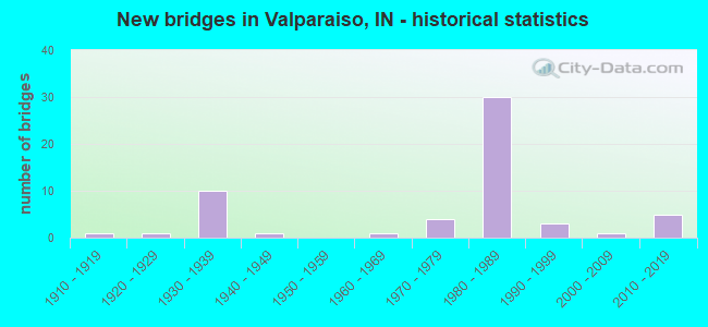
- New bridges - historical statistics
- 11910-1919
- 11920-1929
- 101930-1939
- 11940-1949
- 11960-1969
- 41970-1979
- 301980-1989
- 31990-1999
- 12000-2009
- 52010-2019
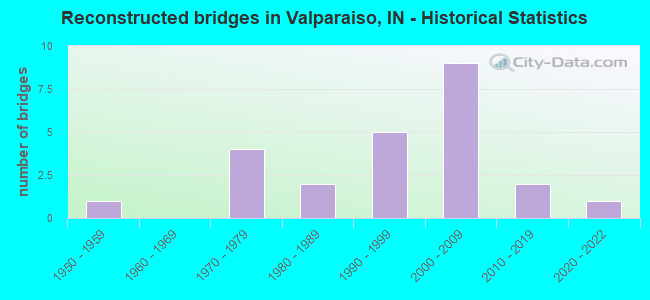
- Reconstructed bridges - Historical Statistics
- 11950-1959
- 01960-1969
- 41970-1979
- 21980-1989
- 51990-1999
- 92000-2009
- 22010-2019
- 12020-2022
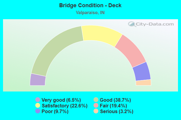
- Bridge Condition - Deck
- 6.5%Very good
- 38.7%Good
- 22.6%Satisfactory
- 19.4%Fair
- 9.7%Poor
- 3.2%Serious
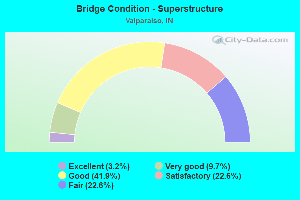
- Bridge Condition - Superstructure
- 3.2%Excellent
- 9.7%Very good
- 41.9%Good
- 22.6%Satisfactory
- 22.6%Fair
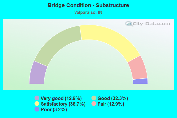
- Bridge Condition - Substructure
- 12.9%Very good
- 32.3%Good
- 38.7%Satisfactory
- 12.9%Fair
- 3.2%Poor
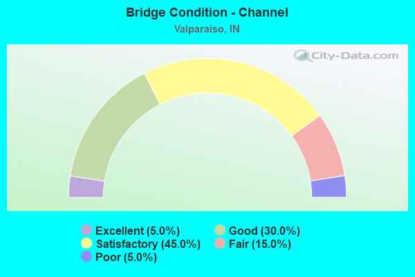
- Bridge Condition - Channel
- 5.0%Excellent
- 30.0%Good
- 45.0%Satisfactory
- 15.0%Fair
- 5.0%Poor
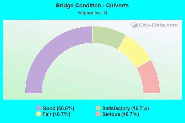
- Bridge Condition - Culverts
- 50.0%Good
- 16.7%Satisfactory
- 16.7%Fair
- 16.7%Serious
Find on map >> Show street view
Structure Number: 17979, Location: 00.21 S US-30 (Lat: 41.450869, Lng: -87.027092), Route carried "under" structure: County highway , Year Built: 1987, Structure Length: 0. m, Average Daily Traffic: 208 (year 2004), Truck Traffic: 5%, Features Intersected: COMFORD ROAD, Facility Carried by Structure: SR 49 SB
Minimum Vertical Clearance: 7.37m (24.18ft), Kilometerpoint: 0.000, Lanes on structure: 3, Lanes under structure: 2, Material/Design: Steel continuous, Design/Construction: Stringer/Multi-beam, Length of Maximum Span: 21.0m (68.9ft)
Find on map >> Show street view
Structure Number: 1798, Location: 01.13 S SR-2 (Lat: 41.453731, Lng: -87.026672), Route carried "under" structure: US 30, Year Built: 1987, Structure Length: 0. m, Average Daily Traffic: 8,635 (year 2010), Truck Traffic: 10%, Features Intersected: US 30/SR 2 EBL, Facility Carried by Structure: SR 49 NB
Minimum Vertical Clearance: 5.23m (17.16ft), Kilometerpoint: 16.689, Lanes on structure: 3, Lanes under structure: 6, Material/Design: Steel continuous, Design/Construction: Stringer/Multi-beam, Length of Maximum Span: 32.3m (106.0ft)
Find on map >> Show street view
Structure Number: 1798, Location: 01.13 S SR-2 (Lat: 41.453731, Lng: -87.026672), Route carried "under" structure: US 30, Year Built: 1987, Structure Length: 0. m, Average Daily Traffic: 8,635 (year 2010), Truck Traffic: 10%, Features Intersected: US 30 WBL, Facility Carried by Structure: SR 49 NB
Minimum Vertical Clearance: 5.05m (16.57ft), Kilometerpoint: 16.689, Lanes on structure: 3, Lanes under structure: 6, Material/Design: Steel continuous, Design/Construction: Stringer/Multi-beam, Length of Maximum Span: 32.3m (106.0ft)
Find on map >> Show street view
Structure Number: 17981, Location: 01.13 S SR-2 (Lat: 41.453961, Lng: -87.027017), Route carried "under" structure: US 30, Year Built: 1987, Structure Length: 0. m, Average Daily Traffic: 8,635 (year 2010), Truck Traffic: 10%, Features Intersected: US 30/SR 2 EBL, Facility Carried by Structure: SR 49 SB
Minimum Vertical Clearance: 5.03m (16.50ft), Kilometerpoint: 16.657, Lanes on structure: 3, Lanes under structure: 6, Material/Design: Steel continuous, Design/Construction: Stringer/Multi-beam, Length of Maximum Span: 32.3m (106.0ft)
Find on map >> Show street view
Structure Number: 17981, Location: 01.13 S SR-2 (Lat: 41.453961, Lng: -87.027017), Route carried "under" structure: US 30, Year Built: 1987, Structure Length: 0. m, Average Daily Traffic: 8,635 (year 2010), Truck Traffic: 10%, Features Intersected: US 30 WBL, Facility Carried by Structure: SR 49 SB
Minimum Vertical Clearance: 5.03m (16.50ft), Kilometerpoint: 16.657, Lanes on structure: 3, Lanes under structure: 6, Material/Design: Steel continuous, Design/Construction: Stringer/Multi-beam, Length of Maximum Span: 32.3m (106.0ft)
Find on map >> Show street view
Structure Number: 17982, Location: 01.13 N US-30 (Lat: 41.469550, Lng: -87.021575), Route carried "under" structure: State highway 2, Year Built: 1987, Structure Length: 0. m, Average Daily Traffic: 11,082 (year 2004), Truck Traffic: 10%, Features Intersected: SR-2 EBL, Facility Carried by Structure: SR 49 NB
Minimum Vertical Clearance: 5.08m (16.67ft), Kilometerpoint: 32.010, Lanes on structure: 2, Lanes under structure: 5, Material/Design: Steel continuous, Design/Construction: Stringer/Multi-beam, Length of Maximum Span: 40.5m (132.9ft)
Find on map >> Show street view
Structure Number: 17982, Location: 01.13 N US-30 (Lat: 41.469550, Lng: -87.021575), Route carried "under" structure: State highway 2, Year Built: 1987, Structure Length: 0. m, Average Daily Traffic: 11,082 (year 2004), Truck Traffic: 10%, Features Intersected: SR-2 WBL, Facility Carried by Structure: SR 49 NB
Minimum Vertical Clearance: 5.08m (16.67ft), Kilometerpoint: 32.010, Lanes on structure: 2, Lanes under structure: 5, Material/Design: Steel continuous, Design/Construction: Stringer/Multi-beam, Length of Maximum Span: 40.5m (132.9ft)
Find on map >> Show street view
Structure Number: 17983, Location: 01.13 N US-30 (Lat: 41.469550, Lng: -87.021889), Route carried "under" structure: State highway 2, Year Built: 1987, Structure Length: 0. m, Average Daily Traffic: 8,928 (year 2020), Truck Traffic: 10%, Features Intersected: SR-2 WBL, Facility Carried by Structure: SR 49 SB
Minimum Vertical Clearance: 4.95m (16.24ft), Kilometerpoint: 31.994, Lanes on structure: 2, Lanes under structure: 5, Material/Design: Steel continuous, Design/Construction: Stringer/Multi-beam, Length of Maximum Span: 40.5m (132.9ft)
Find on map >> Show street view
Structure Number: 17983, Location: 01.13 N US-30 (Lat: 41.469550, Lng: -87.021889), Route carried "under" structure: State highway 2, Year Built: 1987, Structure Length: 0. m, Average Daily Traffic: 9,075 (year 2020), Truck Traffic: 10%, Features Intersected: SR-2 EBL, Facility Carried by Structure: SR 49 SB
Minimum Vertical Clearance: 4.95m (16.24ft), Kilometerpoint: 31.994, Lanes on structure: 2, Lanes under structure: 5, Material/Design: Steel continuous, Design/Construction: Stringer/Multi-beam, Length of Maximum Span: 40.5m (132.9ft)
Find on map >> Show street view
Structure Number: 17988, Location: 00.56 N SR-2 (Lat: 41.478161, Lng: -87.020225), Route carried "under" structure: County highway , Year Built: 1987, Structure Length: 0. m, Average Daily Traffic: 3,513 (year 2004), Truck Traffic: 5%, Features Intersected: CO RD 300 N (EVANS RD), Facility Carried by Structure: SR 49 NB
Minimum Vertical Clearance: 5.05m (16.57ft), Kilometerpoint: 0.000, Lanes on structure: 2, Lanes under structure: 2, Material/Design: Steel continuous, Design/Construction: Stringer/Multi-beam, Length of Maximum Span: 26.2m (86.0ft)
Find on map >> Show street view
Structure Number: 17989, Location: 00.56 N SR-2 (Lat: 41.478150, Lng: -87.020547), Route carried "under" structure: County highway , Year Built: 1987, Structure Length: 0. m, Average Daily Traffic: 3,513 (year 2004), Truck Traffic: 5%, Features Intersected: CO RD 300 N (EVANS RD), Facility Carried by Structure: SR 49 SB
Minimum Vertical Clearance: 4.27m (14.01ft), Kilometerpoint: 0.000, Lanes on structure: 2, Lanes under structure: 2, Material/Design: Steel continuous, Design/Construction: Stringer/Multi-beam, Length of Maximum Span: 26.2m (86.0ft)
Find on map >> Show street view
Structure Number: 17992, Location: 01.02 S US 6 (Lat: 41.538019, Lng: -87.036942), Route carried "under" structure: State highway 49, Year Built: 1984, Structure Length: 0. m, Average Daily Traffic: 15,012 (year 2020), Truck Traffic: 15%, Features Intersected: SR 49 SB, Facility Carried by Structure: CALUMET AVE
Minimum Vertical Clearance: 5.69m (18.67ft), Kilometerpoint: 32.010, Lanes on structure: 2, Lanes under structure: 2, Material/Design: Steel continuous, Design/Construction: Stringer/Multi-beam, Length of Maximum Span: 30.1m (98.8ft)
Find on map >> Show street view
Structure Number: 17992, Location: 01.02 S US 6 (Lat: 41.538019, Lng: -87.036942), Route carried "under" structure: State highway 49, Year Built: 1984, Structure Length: 0. m, Average Daily Traffic: 14,155 (year 2020), Truck Traffic: 15%, Features Intersected: SR 49 NB, Facility Carried by Structure: CALUMET AVE
Minimum Vertical Clearance: 5.69m (18.67ft), Kilometerpoint: 32.010, Lanes on structure: 2, Lanes under structure: 2, Material/Design: Steel continuous, Design/Construction: Stringer/Multi-beam, Length of Maximum Span: 30.1m (98.8ft)
Find on map >> Show street view
Structure Number: 79664, Location: 01.57 N SR-2 (Lat: 41.492761, Lng: -87.021431), Route carried "under" structure: State highway 49, Year Built: 2012, Structure Length: 0. m, Average Daily Traffic: 13,870 (year 2011), Truck Traffic: 34%, Features Intersected: SR-49 SBL, Facility Carried by Structure: CR 400N/VALE RD
Minimum Vertical Clearance: 5.08m (16.67ft), Kilometerpoint: 26.747, Lanes on structure: 2, Lanes under structure: 4, Material/Design: Prestressed concrete continuous, Design/Construction: Tee Beam, Length of Maximum Span: 27.4m (89.9ft)
Find on map >> Show street view
Structure Number: 79664, Location: 01.57 N SR-2 (Lat: 41.492761, Lng: -87.021431), Route carried "under" structure: State highway 49, Year Built: 2012, Structure Length: 0. m, Average Daily Traffic: 13,870 (year 2011), Truck Traffic: 34%, Features Intersected: SR-49 NBL, Facility Carried by Structure: CR 400N/VALE RD
Minimum Vertical Clearance: 5.03m (16.50ft), Kilometerpoint: 26.747, Lanes on structure: 2, Lanes under structure: 4, Material/Design: Prestressed concrete continuous, Design/Construction: Tee Beam, Length of Maximum Span: 27.4m (89.9ft)