Bridge Statistics for Van Buren, New York (NY)
Condition, Traffic, Stress, Structural Evaluation, Project Costs
- National Bridge Inventory (NBI) Statistics
- 43Number of bridges
- 433ft / 132mTotal length
- $60,068,000Total costs
- 370,127Total average daily traffic
- 14,622Total average daily truck traffic
- National Bridge Inventory (NBI) Registered Bridges for Van Buren
- No street view available for this location
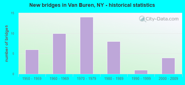
- New bridges - historical statistics
- 61950-1959
- 101960-1969
- 141970-1979
- 81980-1989
- 11990-1999
- 42000-2009
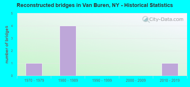
- Reconstructed bridges - Historical Statistics
- 11970-1979
- 41980-1989
- 01990-1999
- 02000-2009
- 12010-2019
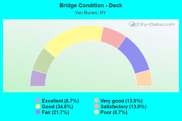
- Bridge Condition - Deck
- 8.7%Excellent
- 13.0%Very good
- 34.8%Good
- 13.0%Satisfactory
- 21.7%Fair
- 8.7%Poor
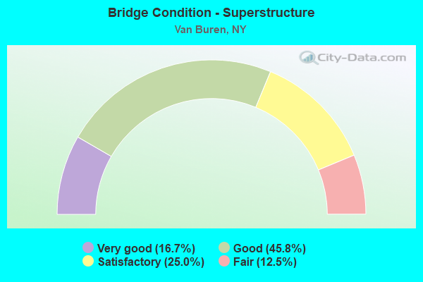
- Bridge Condition - Superstructure
- 16.7%Very good
- 45.8%Good
- 25.0%Satisfactory
- 12.5%Fair
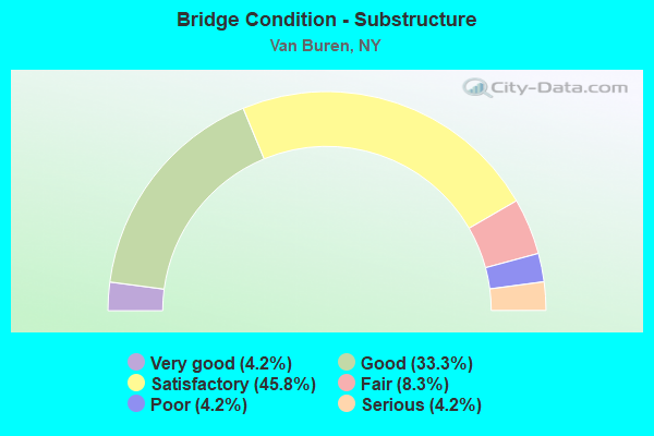
- Bridge Condition - Substructure
- 4.2%Very good
- 33.3%Good
- 45.8%Satisfactory
- 8.3%Fair
- 4.2%Poor
- 4.2%Serious
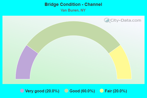
- Bridge Condition - Channel
- 20.0%Very good
- 60.0%Good
- 20.0%Fair
Find on map >> Show street view
Structure Number: 1053691, Location: JCT OF RTS I-690 SB + 31 (Lat: 43.151286, Lng: -76.357075), Route carried "on" structure: State highway 690, Year Built: 1969, Status: Open, Structure Length: 4.30m (14.11ft), Average Daily Traffic: 7,970 (year 2006), Truck Traffic: 11%, Average Future Daily Traffic: 10,382 (year 2040), Design Load: HS 20, Features Intersected: RTE 31
Minimum Vertical Clearance: 30+ m (98+ ft), Kilometerpoint: 6.967, Lanes on structure: 2, Lanes under structure: 4, Base Highway Network: Yes, Owner: State Highway Agency, Approaching Roadway Width: 11.6m (38.1ft), Skew: 2 degrees, Material/Design: Steel, Design/Construction: Stringer/Multi-beam, Number Of Spans In Main Unit: 1, Length of Maximum Span: 41.1m (134.8ft), Curb-To-Curb Width: 9.5m (31.2ft), Out-to-Out Width: 10.7m (35.1ft)
Condition: Deck: Good, Superstructure: Good, Substructure: Good, Operating Rating: 88.0 metric tons, Method Used To Determine Operating Rating: Load Factor (LF), Inventory Rating: 52.6 metric tons, Method Used To Determine Inventory Rating: Load Factor (LF), Structural Evaluation: Better than present minimum criteria, Deck Geometry: High priority of replacement, Underclear: Meets minimum limits, Approach Roadway Alignment: Equal to present desirable criteria, Length Of Structure Improvement: 4.29m (14.07ft), Designated Inspection Frequency: Every 24 months, Inspection Date: April 2021, Bridge Improvement Cost: $1,167,000, Roadway Improvement Cost: $683,000, Total Project Cost: $1,850,000 ( Estimate for 2021), Deck Structure Type: Concrete Cast-file-Place, Wearing Surface/Protective System: Wearing Surface: Monolithic Concrete
Find on map >> Show street view
Structure Number: 1053692, Location: JCT OF RTS I-690 NB + 31 (Lat: 43.151300, Lng: -76.356789), Route carried "on" structure: State highway 690, Year Built: 1969, Status: Open, Structure Length: 4.30m (14.11ft), Average Daily Traffic: 7,970 (year 2006), Truck Traffic: 11%, Average Future Daily Traffic: 10,382 (year 2040), Design Load: HS 20, Features Intersected: RTE 31
Minimum Vertical Clearance: 30+ m (98+ ft), Kilometerpoint: 6.967, Lanes on structure: 2, Lanes under structure: 4, Base Highway Network: Yes, Owner: State Highway Agency, Approaching Roadway Width: 11.6m (38.1ft), Skew: 2 degrees, Material/Design: Steel, Design/Construction: Stringer/Multi-beam, Number Of Spans In Main Unit: 1, Length of Maximum Span: 41.1m (134.8ft), Curb-To-Curb Width: 9.5m (31.2ft), Out-to-Out Width: 10.7m (35.1ft)
Condition: Deck: Good, Superstructure: Good, Substructure: Satisfactory, Operating Rating: 88.9 metric tons, Method Used To Determine Operating Rating: Load Factor (LF), Inventory Rating: 52.6 metric tons, Method Used To Determine Inventory Rating: Load Factor (LF), Structural Evaluation: Equal to present minimum criteria, Deck Geometry: High priority of replacement, Underclear: Better than present minimum criteria, Approach Roadway Alignment: Equal to present desirable criteria, Length Of Structure Improvement: 4.29m (14.07ft), Designated Inspection Frequency: Every 24 months, Inspection Date: April 2021, Bridge Improvement Cost: $1,167,000, Roadway Improvement Cost: $683,000, Total Project Cost: $1,850,000 ( Estimate for 2021), Deck Structure Type: Concrete Cast-file-Place, Wearing Surface/Protective System: Wearing Surface: Integral Concrete
Find on map >> Show street view
Structure Number: 1053711, Location: JCT OF RTS 690 SB + 370 (Lat: 43.163072, Lng: -76.363667), Route carried "on" structure: State highway 690, Year Built: 1969, Status: Open, Structure Length: 4.42m (14.50ft), Average Daily Traffic: 8,218 (year 2020), Truck Traffic: 8%, Average Future Daily Traffic: 10,706 (year 2040), Design Load: HS 20, Features Intersected: RTE 370
Minimum Vertical Clearance: 30+ m (98+ ft), Kilometerpoint: 20.064, Lanes on structure: 2, Lanes under structure: 5, Base Highway Network: Yes, Owner: State Highway Agency, Approaching Roadway Width: 12.2m (40.0ft), Skew: 1 degrees, Material/Design: Steel, Design/Construction: Stringer/Multi-beam, Number Of Spans In Main Unit: 1, Length of Maximum Span: 42.3m (138.8ft), Curb-To-Curb Width: 9.6m (31.5ft), Out-to-Out Width: 10.7m (35.1ft)
Condition: Deck: Very good, Superstructure: Very good, Substructure: Good, Operating Rating: 92.5 metric tons, Method Used To Determine Operating Rating: Load Factor (LF), Inventory Rating: 55.3 metric tons, Method Used To Determine Inventory Rating: Load Factor (LF), Structural Evaluation: Better than present minimum criteria, Deck Geometry: High priority of replacement, Underclear: Somewhat better than minimum adequacy, Approach Roadway Alignment: Equal to present desirable criteria, Length Of Structure Improvement: 4.41m (14.47ft), Designated Inspection Frequency: Every 24 months, Inspection Date: May 2021, Bridge Improvement Cost: $1,215,000, Roadway Improvement Cost: $711,000, Total Project Cost: $1,926,000 ( Estimate for 2021), Deck Structure Type: Concrete Cast-file-Place, Wearing Surface/Protective System: Wearing Surface: Other
Find on map >> Show street view
Structure Number: 1053712, Location: JCT OF RTS 690 NB + 370 (Lat: 43.163108, Lng: -76.363397), Route carried "on" structure: State highway 690, Year Built: 1969, Status: Open, Structure Length: 4.42m (14.50ft), Average Daily Traffic: 8,218 (year 2020), Truck Traffic: 8%, Average Future Daily Traffic: 10,706 (year 2040), Design Load: HS 20, Features Intersected: RTE 370
Minimum Vertical Clearance: 30+ m (98+ ft), Kilometerpoint: 20.064, Lanes on structure: 2, Lanes under structure: 5, Base Highway Network: Yes, Owner: State Highway Agency, Approaching Roadway Width: 7.3m (24.0ft), Skew: 1 degrees, Material/Design: Steel, Design/Construction: Stringer/Multi-beam, Number Of Spans In Main Unit: 1, Length of Maximum Span: 42.3m (138.8ft), Curb-To-Curb Width: 9.6m (31.5ft), Out-to-Out Width: 10.7m (35.1ft)
Condition: Deck: Very good, Superstructure: Very good, Substructure: Good, Operating Rating: 49.9 metric tons, Method Used To Determine Operating Rating: Load and Resistance Factor Rating (LRFR) rating reported by rating factor(RF) method using HL-93 loadings, Inventory Rating: 38.2 metric tons, Method Used To Determine Inventory Rating: Load and Resistance Factor Rating (LRFR) rating reported by rating factor(RF) method using HL-93 loadings, Structural Evaluation: Better than present minimum criteria, Deck Geometry: High priority of replacement, Underclear: Somewhat better than minimum adequacy, Approach Roadway Alignment: Equal to present desirable criteria, Length Of Structure Improvement: 4.41m (14.47ft), Designated Inspection Frequency: Every 24 months, Inspection Date: May 2021, Bridge Improvement Cost: $1,215,000, Roadway Improvement Cost: $711,000, Total Project Cost: $1,926,000 ( Estimate for 2021), Deck Structure Type: Concrete Cast-file-Place, Wearing Surface/Protective System: Wearing Surface: Other
Find on map >> Show street view
Structure Number: 1061741, Location: BETWEEN EXITS 3 & 4 - I69 (Lat: 43.113114, Lng: -76.269989), Route carried "on" structure: Interstate 690, Year Built: 1971, Year Reconstructed: 1988, Status: Open, Structure Length: 3.75m (12.30ft), Average Daily Traffic: 11,439 (year 2018), Truck Traffic: 11%, Average Future Daily Traffic: 16,500 (year 2040), Design Load: HS 20, Features Intersected: JOHN GLENN RAMP F
Minimum Vertical Clearance: 30+ m (98+ ft), Kilometerpoint: 1.689, Lanes on structure: 2, Lanes under structure: 2, Base Highway Network: Yes, Owner: State Highway Agency, Approaching Roadway Width: 11.0m (36.1ft), Skew: 1 degrees, Material/Design: Steel, Design/Construction: Stringer/Multi-beam, Number Of Spans In Main Unit: 1, Length of Maximum Span: 35.9m (117.8ft), Curb-To-Curb Width: 11.4m (37.4ft), Out-to-Out Width: 12.4m (40.7ft)
Condition: Deck: Satisfactory, Superstructure: Good, Substructure: Satisfactory, Operating Rating: 88.0 metric tons, Method Used To Determine Operating Rating: Load Factor (LF), Inventory Rating: 52.6 metric tons, Method Used To Determine Inventory Rating: Load Factor (LF), Structural Evaluation: Equal to present minimum criteria, Deck Geometry: Somewhat better than minimum adequacy, Underclear: Superior to present desirable criteria, Approach Roadway Alignment: Equal to present desirable criteria, Length Of Structure Improvement: 3.74m (12.27ft), Designated Inspection Frequency: Every 24 months, Inspection Date: April 2020, Bridge Improvement Cost: $1,116,000, Roadway Improvement Cost: $654,000, Total Project Cost: $1,770,000 ( Estimate for 2021), Deck Structure Type: Concrete Cast-file-Place, Wearing Surface/Protective System: Wearing Surface: Integral Concrete, Deck Protection: Epoxy Coated Reinforcing
Find on map >> Show street view
Structure Number: 1061742, Location: BETWEEN EXITS 3 & 4 - I69 (Lat: 43.113303, Lng: -76.270058), Route carried "on" structure: Interstate 690, Year Built: 1971, Year Reconstructed: 1988, Status: Open, Structure Length: 3.75m (12.30ft), Average Daily Traffic: 15,408 (year 2002), Truck Traffic: 13%, Design Load: HS 20, Features Intersected: JOHN GLENN RAMP F
Minimum Vertical Clearance: 30+ m (98+ ft), Kilometerpoint: 1.689, Lanes on structure: 3, Lanes under structure: 2, Base Highway Network: Yes, Owner: State Highway Agency, Approaching Roadway Width: 15.2m (49.9ft), Skew: 1 degrees, Material/Design: Steel, Design/Construction: Stringer/Multi-beam, Number Of Spans In Main Unit: 1, Length of Maximum Span: 35.9m (117.8ft), Curb-To-Curb Width: 14.0m (45.9ft), Out-to-Out Width: 15.0m (49.2ft)
Condition: Deck: Good, Superstructure: Good, Substructure: Satisfactory, Operating Rating: 82.6 metric tons, Method Used To Determine Operating Rating: Load Factor (LF), Inventory Rating: 49.0 metric tons, Method Used To Determine Inventory Rating: Load Factor (LF), Structural Evaluation: Equal to present minimum criteria, Deck Geometry: Meets minimum limits, Underclear: Superior to present desirable criteria, Approach Roadway Alignment: Equal to present desirable criteria, Length Of Structure Improvement: 3.74m (12.27ft), Designated Inspection Frequency: Every 24 months, Inspection Date: April 2020, Bridge Improvement Cost: $1,417,000, Roadway Improvement Cost: $830,000, Total Project Cost: $2,247,000 ( Estimate for 2021), Deck Structure Type: Concrete Cast-file-Place, Wearing Surface/Protective System: Wearing Surface: Integral Concrete, Deck Protection: Epoxy Coated Reinforcing
Find on map >> Show street view
Structure Number: 1061751, Location: BETWEEN EXITS 1 & 2- I690 (Lat: 43.111733, Lng: -76.286133), Route carried "on" structure: Interstate 690, Year Built: 1971, Year Reconstructed: 1988, Status: Open, Structure Length: 2.80m (9.19ft), Average Daily Traffic: 11,439 (year 2018), Truck Traffic: 11%, Average Future Daily Traffic: 16,500 (year 2040), Design Load: HS 20, Features Intersected: JONES RD - CR 28
Minimum Vertical Clearance: 30+ m (98+ ft), Kilometerpoint: 0.354, Lanes on structure: 3, Lanes under structure: 3, Base Highway Network: Yes, Owner: State Highway Agency, Approaching Roadway Width: 14.0m (45.9ft), Material/Design: Steel, Design/Construction: Stringer/Multi-beam, Number Of Spans In Main Unit: 1, Length of Maximum Span: 26.8m (87.9ft), Curb-To-Curb Width: 14.0m (45.9ft), Out-to-Out Width: 15.0m (49.2ft)
Condition: Deck: Good, Superstructure: Good, Substructure: Satisfactory, Operating Rating: 76.2 metric tons, Method Used To Determine Operating Rating: Load Factor (LF), Inventory Rating: 45.4 metric tons, Method Used To Determine Inventory Rating: Load Factor (LF), Structural Evaluation: Equal to present minimum criteria, Deck Geometry: Meets minimum limits, Underclear: Meets minimum limits, Approach Roadway Alignment: Equal to present desirable criteria, Length Of Structure Improvement: 2.80m (9.19ft), Designated Inspection Frequency: Every 24 months, Inspection Date: June 2021, Bridge Improvement Cost: $1,227,000, Roadway Improvement Cost: $718,000, Total Project Cost: $1,945,000 ( Estimate for 2021), Deck Structure Type: Concrete Cast-file-Place, Wearing Surface/Protective System: Wearing Surface: Epoxy Overlay, Deck Protection: Epoxy Coated Reinforcing
Find on map >> Show street view
Structure Number: 1061752, Location: BETWEEN EXITS 1 & 2- I690 (Lat: 43.111969, Lng: -76.286111), Route carried "on" structure: Interstate 690, Year Built: 1971, Year Reconstructed: 1988, Status: Open, Structure Length: 2.80m (9.19ft), Average Daily Traffic: 15,408 (year 2002), Truck Traffic: 13%, Design Load: HS 20, Features Intersected: JONES RD - CR 28
Minimum Vertical Clearance: 30+ m (98+ ft), Kilometerpoint: 0.354, Lanes on structure: 3, Lanes under structure: 3, Base Highway Network: Yes, Owner: State Highway Agency, Approaching Roadway Width: 14.0m (45.9ft), Material/Design: Steel, Design/Construction: Stringer/Multi-beam, Number Of Spans In Main Unit: 1, Length of Maximum Span: 26.8m (87.9ft), Curb-To-Curb Width: 14.0m (45.9ft), Out-to-Out Width: 15.0m (49.2ft)
Condition: Deck: Good, Superstructure: Good, Substructure: Satisfactory, Operating Rating: 76.2 metric tons, Method Used To Determine Operating Rating: Load Factor (LF), Inventory Rating: 45.4 metric tons, Method Used To Determine Inventory Rating: Load Factor (LF), Structural Evaluation: Equal to present minimum criteria, Deck Geometry: Meets minimum limits, Underclear: Meets minimum limits, Approach Roadway Alignment: Equal to present desirable criteria, Length Of Structure Improvement: 2.80m (9.19ft), Designated Inspection Frequency: Every 24 months, Inspection Date: June 2021, Bridge Improvement Cost: $1,227,000, Roadway Improvement Cost: $718,000, Total Project Cost: $1,945,000 ( Estimate for 2021), Deck Structure Type: Concrete Cast-file-Place, Wearing Surface/Protective System: Wearing Surface: Epoxy Overlay, Deck Protection: Epoxy Coated Reinforcing
Find on map >> Show street view
Structure Number: 106179, Location: .1 MI N JCT I690 & I90 (Lat: 43.112906, Lng: -76.269900), Route carried "on" structure: Ramp State highway 690, Year Built: 1971, Status: Open, Structure Length: 3.20m (10.50ft), Average Daily Traffic: 1,889 (year 2017), Truck Traffic: 9%, Average Future Daily Traffic: 2,724 (year 2040), Design Load: HS 20, Features Intersected: JOHN GLENN RAMP F
Minimum Vertical Clearance: 30+ m (98+ ft), Kilometerpoint: 0.161, Lanes on structure: 1, Lanes under structure: 2, Owner: State Highway Agency, Approaching Roadway Width: 7.9m (25.9ft), Skew: 3 degrees, Material/Design: Steel, Design/Construction: Stringer/Multi-beam, Number Of Spans In Main Unit: 1, Length of Maximum Span: 30.4m (99.7ft), Curb-To-Curb Width: 7.9m (25.9ft), Out-to-Out Width: 8.8m (28.9ft)
Condition: Deck: Fair, Superstructure: Fair, Substructure: Satisfactory, Operating Rating: 46.7 metric tons, Method Used To Determine Operating Rating: Load and Resistance Factor Rating (LRFR) rating reported by rating factor(RF) method using HL-93 loadings, Inventory Rating: 36.0 metric tons, Method Used To Determine Inventory Rating: Load and Resistance Factor Rating (LRFR) rating reported by rating factor(RF) method using HL-93 loadings, Structural Evaluation: Somewhat better than minimum adequacy, Deck Geometry: Equal to present desirable criteria, Underclear: High priority of corrective action, Approach Roadway Alignment: Equal to present desirable criteria, Length Of Structure Improvement: 3.20m (10.50ft), Designated Inspection Frequency: Every 24 months, Inspection Date: June 2020, Bridge Improvement Cost: $816,000, Roadway Improvement Cost: $478,000, Total Project Cost: $1,294,000 ( Estimate for 2021), Deck Structure Type: Concrete Cast-file-Place, Wearing Surface/Protective System: Wearing Surface: Latex Concrete
Find on map >> Show street view
Structure Number: 106181, Location: 3.5 MI NW JCT I690 & I90 (Lat: 43.128983, Lng: -76.319319), Route carried "on" structure: County highway , Year Built: 1971, Status: Open, Structure Length: 7.07m (23.20ft), Average Daily Traffic: 4,520 (year 2020), Truck Traffic: 4%, Average Future Daily Traffic: 5,490 (year 2040), Design Load: HS 20, Features Intersected: 690 690 33011034, RTE 69, Facility Carried by Structure: VAN BUREN RD
Minimum Vertical Clearance: 30+ m (98+ ft), Kilometerpoint: 0.853, Lanes on structure: 2, Lanes under structure: 4, Owner: State Highway Agency, Approaching Roadway Width: 9.1m (29.9ft), Skew: 4 degrees, Material/Design: Steel, Design/Construction: Stringer/Multi-beam, Number Of Spans In Main Unit: 2, Length of Maximum Span: 36.5m (119.8ft), Curb or Sidewalk Widths: Left: 0.5m (1.6ft), Right: 0.5m (1.6ft), Curb-To-Curb Width: 9.1m (29.9ft), Out-to-Out Width: 10.6m (34.8ft)
Condition: Deck: Fair, Superstructure: Good, Substructure: Fair, Operating Rating: 82.6 metric tons, Method Used To Determine Operating Rating: Load Factor (LF), Inventory Rating: 49.0 metric tons, Method Used To Determine Inventory Rating: Load Factor (LF), Structural Evaluation: Somewhat better than minimum adequacy, Deck Geometry: Meets minimum limits, Underclear: High priority of corrective action, Approach Roadway Alignment: Equal to present desirable criteria, Length Of Structure Improvement: 7.07m (23.20ft), Designated Inspection Frequency: Every 24 months, Inspection Date: August 2020, Bridge Improvement Cost: $1,869,000, Roadway Improvement Cost: $1,095,000, Total Project Cost: $2,964,000 ( Estimate for 2021), Deck Structure Type: Concrete Cast-file-Place, Wearing Surface/Protective System: Wearing Surface: Monolithic Concrete
Find on map >> Show street view
Structure Number: 106182, Location: 4.5 MI NW JCT SH 690 & I9 (Lat: 43.137156, Lng: -76.335006), Route carried "on" structure: County highway , Year Built: 1971, Status: Open, Structure Length: 7.07m (23.20ft), Average Daily Traffic: 1,639 (year 2020), Truck Traffic: 3%, Average Future Daily Traffic: 2,027 (year 2040), Design Load: HS 20, Features Intersected: RTE 690, Facility Carried by Structure: CANTON ST
Minimum Vertical Clearance: 30+ m (98+ ft), Kilometerpoint: 2.027, Lanes on structure: 2, Lanes under structure: 4, Owner: State Highway Agency, Approaching Roadway Width: 8.5m (27.9ft), Skew: 3 degrees, Material/Design: Steel, Design/Construction: Stringer/Multi-beam, Number Of Spans In Main Unit: 2, Length of Maximum Span: 35.9m (117.8ft), Curb-To-Curb Width: 9.1m (29.9ft), Out-to-Out Width: 10.0m (32.8ft)
Condition: Deck: Good, Superstructure: Satisfactory, Substructure: Satisfactory, Operating Rating: 84.4 metric tons, Method Used To Determine Operating Rating: Load Factor (LF), Inventory Rating: 50.8 metric tons, Method Used To Determine Inventory Rating: Load Factor (LF), Structural Evaluation: Equal to present minimum criteria, Deck Geometry: Somewhat better than minimum adequacy, Underclear: High priority of corrective action, Approach Roadway Alignment: Equal to present desirable criteria, Length Of Structure Improvement: 7.07m (23.20ft), Designated Inspection Frequency: Every 24 months, Inspection Date: October 2020, Bridge Improvement Cost: $1,521,000, Roadway Improvement Cost: $891,000, Total Project Cost: $2,411,000 ( Estimate for 2021), Deck Structure Type: Concrete Cast-file-Place, Wearing Surface/Protective System: Wearing Surface: Monolithic Concrete
Find on map >> Show street view
Structure Number: 107316, Location: 1M W.RT48&690I OVER 690I (Lat: 43.112975, Lng: -76.290447), Route carried "on" structure: Ramp Interstate , Year Built: 1987, Status: Open, Structure Length: 7.19m (23.59ft), Average Daily Traffic: 1,771 (year 2019), Truck Traffic: 14%, Average Future Daily Traffic: 2,554 (year 2040), Design Load: HS 20, Features Intersected: 690I690I33011016 WB, RTE, Facility Carried by Structure: TOLL ROAD
Minimum Vertical Clearance: 30+ m (98+ ft), Kilometerpoint: 0.257, Lanes on structure: 2, Lanes under structure: 5, Toll: On toll road, Owner: State Highway Agency, Approaching Roadway Width: 16.2m (53.1ft), Skew: 22 degrees, Material/Design: Steel continuous, Design/Construction: Stringer/Multi-beam, Number Of Spans In Main Unit: 2, Length of Maximum Span: 36.8m (120.7ft), Curb-To-Curb Width: 15.4m (50.5ft), Out-to-Out Width: 17.0m (55.8ft)
Condition: Deck: Fair, Superstructure: Good, Substructure: Satisfactory, Operating Rating: 96.5 metric tons, Method Used To Determine Operating Rating: Field evaluation and documented engineering judgment, Inventory Rating: 32.7 metric tons, Method Used To Determine Inventory Rating: Field evaluation and documented engineering judgment, Structural Evaluation: Equal to present minimum criteria, Deck Geometry: Superior to present desirable criteria, Underclear: Somewhat better than minimum adequacy, Approach Roadway Alignment: Equal to present desirable criteria, Length Of Structure Improvement: 7.19m (23.59ft), Designated Inspection Frequency: Every 24 months, Inspection Date: April 2021, Bridge Improvement Cost: $2,683,000, Roadway Improvement Cost: $1,571,000, Total Project Cost: $4,254,000 ( Estimate for 2021), Deck Structure Type: Concrete Cast-file-Place, Wearing Surface/Protective System: Wearing Surface: Integral Concrete, Deck Protection: Epoxy Coated Reinforcing
Find on map >> Show street view
Structure Number: 331296, Location: 3 MI EAST BALDWINSVILLE (Lat: 43.150486, Lng: -76.377319), Route carried "on" structure: County highway , Year Built: 1988, Status: Open, Structure Length: 1.62m (5.31ft), Average Daily Traffic: 1,776 (year 2016), Truck Traffic: 5%, Average Future Daily Traffic: 2,486 (year 2036), Design Load: HS 20, Features Intersected: DEAD CREEK, Facility Carried by Structure: CR272 W DEADCK RD
Minimum Vertical Clearance: 30+ m (98+ ft), Kilometerpoint: 6.581, Lanes on structure: 2, Owner: County Highway Agency, Approaching Roadway Width: 10.4m (34.1ft), Material/Design: Steel, Design/Construction: Stringer/Multi-beam, Number Of Spans In Main Unit: 1, Length of Maximum Span: 15.2m (49.9ft), Curb-To-Curb Width: 10.4m (34.1ft), Out-to-Out Width: 11.0m (36.1ft)
Condition: Deck: Satisfactory, Superstructure: Satisfactory, Substructure: Good, Channel: Very good, Operating Rating: 88.9 metric tons, Method Used To Determine Operating Rating: Load Factor (LF), Inventory Rating: 53.5 metric tons, Method Used To Determine Inventory Rating: Load Factor (LF), Structural Evaluation: Equal to present minimum criteria, Deck Geometry: Equal to present minimum criteria, Waterway Adequacy: Equal to present desirable criteria, Approach Roadway Alignment: Equal to present minimum criteria, Length Of Structure Improvement: 1.61m (5.28ft), Designated Inspection Frequency: Every 24 months, Inspection Date: June 2020, Bridge Improvement Cost: $514,000, Roadway Improvement Cost: $301,000, Total Project Cost: $815,000 ( Estimate for 2021), Deck Structure Type: Concrete Cast-file-Place, Wearing Surface/Protective System: Wearing Surface: Integral Concrete, Deck Protection: Epoxy Coated Reinforcing
Find on map >> Show street view
Structure Number: 331322, Location: .5 MI SE JCT SH 173 & I90 (Lat: 43.085136, Lng: -76.329069), Route carried "on" structure: State highway 173, Year Built: 2001, Status: Open, Structure Length: 2.65m (8.69ft), Average Daily Traffic: 1,502 (year 2018), Truck Traffic: 5%, Average Future Daily Traffic: 2,099 (year 2040), Design Load: HS 25 or greater, Features Intersected: CSX TRANS/AMTRAK
Minimum Vertical Clearance: 30+ m (98+ ft), Kilometerpoint: 4.891, Lanes on structure: 2, Base Highway Network: Yes, Owner: County Highway Agency, Approaching Roadway Width: 14.3m (46.9ft), Skew: 2 degrees, Material/Design: Steel, Design/Construction: Stringer/Multi-beam, Number Of Spans In Main Unit: 1, Length of Maximum Span: 24.2m (79.4ft), Curb or Sidewalk Widths: Left: 1.5m (4.9ft), Right: 1.5m (4.9ft), Curb-To-Curb Width: 14.4m (47.2ft), Out-to-Out Width: 18.0m (59.1ft)
Condition: Deck: Good, Superstructure: Very good, Substructure: Good, Operating Rating: 77.4 metric tons, Method Used To Determine Operating Rating: Load and Resistance Factor Rating (LRFR) rating reported by rating factor(RF) method using HL-93 loadings, Inventory Rating: 59.6 metric tons, Method Used To Determine Inventory Rating: Load and Resistance Factor Rating (LRFR) rating reported by rating factor(RF) method using HL-93 loadings, Structural Evaluation: Better than present minimum criteria, Deck Geometry: Superior to present desirable criteria, Underclear: Equal to present minimum criteria, Approach Roadway Alignment: Meets minimum limits, Length Of Structure Improvement: 2.65m (8.69ft), Designated Inspection Frequency: Every 24 months, Inspection Date: June 2021, Bridge Improvement Cost: $1,182,000, Roadway Improvement Cost: $692,000, Total Project Cost: $1,874,000 ( Estimate for 2021), Deck Structure Type: Concrete Cast-file-Place, Wearing Surface/Protective System: Wearing Surface: Integral Concrete, Deck Protection: Epoxy Coated Reinforcing
Find on map >> Show street view
Structure Number: 336151, Location: 4.5MI NE JORDAN NEAR RT31 (Lat: 43.096328, Lng: -76.388461), Route carried "on" structure: County highway , Year Built: 1992, Status: Open, Structure Length: 0.79m (2.59ft), Average Daily Traffic: 1,391 (year 2020), Truck Traffic: 6%, Average Future Daily Traffic: 1,944 (year 2040), Features Intersected: DEAD CREEK, Facility Carried by Structure: CR204 IONIA CRNS
Minimum Vertical Clearance: 30+ m (98+ ft), Kilometerpoint: 0.032, Lanes on structure: 2, Owner: County Highway Agency, Approaching Roadway Width: 10.1m (33.1ft), Skew: 1 degrees, Material/Design: Concrete, Design/Construction: Arch - Deck, Number Of Spans In Main Unit: 1, Length of Maximum Span: 7.3m (24.0ft), Curb-To-Curb Width: 10.4m (34.1ft), Out-to-Out Width: 11.0m (36.1ft)
Condition: Superstructure: Satisfactory, Substructure: Good, Channel: Fair, Operating Rating: 75.7 metric tons, Method Used To Determine Operating Rating: Field evaluation and documented engineering judgment, Inventory Rating: 19.6 metric tons, Method Used To Determine Inventory Rating: Field evaluation and documented engineering judgment, Structural Evaluation: Somewhat better than minimum adequacy, Deck Geometry: Equal to present minimum criteria, Waterway Adequacy: Equal to present desirable criteria, Approach Roadway Alignment: Equal to present desirable criteria, Length Of Structure Improvement: 0.79m (2.59ft), Designated Inspection Frequency: Every 24 months, Inspection Date: April 2020, Bridge Improvement Cost: $206,000, Roadway Improvement Cost: $121,000, Total Project Cost: $327,000 ( Estimate for 2021), Wearing Surface/Protective System: Wearing Surface: Bituminous
Find on map >> Show street view
Structure Number: 337173, Location: 2.1 Mi East Jacks Reef (Lat: 43.097639, Lng: -76.387458), Route carried "on" structure: County highway , Year Built: 2001, Status: Open, Structure Length: 0.67m (2.20ft), Design Load: HS 20, Features Intersected: Dead Creek, Facility Carried by Structure: Elderberry Street
Minimum Vertical Clearance: 32.69m (107.25ft), Kilometerpoint: 0.193, Lanes on structure: 1, Owner: County Highway Agency, Approaching Roadway Width: 7.9m (25.9ft), Material/Design: Concrete, Design/Construction: Frame, Number Of Spans In Main Unit: 1, Length of Maximum Span: 6.1m (20.0ft), Curb-To-Curb Width: 7.9m (25.9ft), Out-to-Out Width: 9.1m (29.9ft)
Condition: Deck: Fair, Superstructure: Fair, Substructure: Good, Channel: Good, Operating Rating: 76.9 metric tons, Method Used To Determine Operating Rating: Field evaluation and documented engineering judgment, Inventory Rating: 32.7 metric tons, Method Used To Determine Inventory Rating: Field evaluation and documented engineering judgment, Structural Evaluation: Somewhat better than minimum adequacy, Deck Geometry: Equal to present minimum criteria, Waterway Adequacy: Equal to present desirable criteria, Approach Roadway Alignment: Equal to present desirable criteria, Designated Inspection Frequency: Every 24 months, Inspection Date: June 2021, Wearing Surface/Protective System: Wearing Surface: Bituminous
Find on map >> Show street view
Structure Number: 4053701, Location: 1.7 MI W SH 48 & CANAL (Lat: 43.161303, Lng: -76.362744), Route carried "on" structure: State highway 690, Year Built: 1969, Status: Open, Structure Length: 13.26m (43.50ft), Average Daily Traffic: 8,218 (year 2020), Truck Traffic: 8%, Average Future Daily Traffic: 10,706 (year 2040), Design Load: HS 20, Features Intersected: ERIE CANAL/SEN RV
Minimum Vertical Clearance: 30+ m (98+ ft), Kilometerpoint: 19.952, Lanes on structure: 2, Base Highway Network: Yes, Owner: State Highway Agency, Approaching Roadway Width: 11.0m (36.1ft), Navigation Control: Yes ( Vertical Clearance: 6.0m (19.7ft), Horizontal Clearance: 60.9m (199.8ft)), Material/Design: Steel continuous, Design/Construction: Stringer/Multi-beam, Number Of Spans In Main Unit: 3, Length of Maximum Span: 64.0m (210.0ft), Curb-To-Curb Width: 9.7m (31.8ft), Out-to-Out Width: 10.6m (34.8ft)
Condition: Deck: Excellent, Superstructure: Good, Substructure: Satisfactory, Channel: Good, Operating Rating: 32.1 metric tons, Method Used To Determine Operating Rating: Load and Resistance Factor Rating (LRFR) rating reported by rating factor(RF) method using HL-93 loadings, Inventory Rating: 24.6 metric tons, Method Used To Determine Inventory Rating: Load and Resistance Factor Rating (LRFR) rating reported by rating factor(RF) method using HL-93 loadings, Structural Evaluation: Equal to present minimum criteria, Deck Geometry: Meets minimum limits, Waterway Adequacy: Equal to present desirable criteria, Approach Roadway Alignment: Equal to present desirable criteria, Length Of Structure Improvement: 13.25m (43.47ft), Designated Inspection Frequency: Every 24 months, Underwater Inspection Frequency: Every 60 months, Inspection Date: November 2020, Underwater Inspection Date: July 2017, Bridge Improvement Cost: $2,755,000, Roadway Improvement Cost: $1,613,000, Total Project Cost: $4,368,000 ( Estimate for 2021), Deck Structure Type: Concrete Cast-file-Place, Wearing Surface/Protective System: Wearing Surface: Other
Find on map >> Show street view
Structure Number: 4053702, Location: 1.7 MI W SH 48 & CANAL (Lat: 43.161411, Lng: -76.362517), Route carried "on" structure: State highway 690, Year Built: 1969, Status: Open, Structure Length: 13.26m (43.50ft), Average Daily Traffic: 8,218 (year 2020), Truck Traffic: 8%, Average Future Daily Traffic: 10,706 (year 2040), Design Load: HS 20, Features Intersected: ERIE CANAL/SEN RV
Minimum Vertical Clearance: 30+ m (98+ ft), Kilometerpoint: 19.952, Lanes on structure: 2, Base Highway Network: Yes, Owner: State Highway Agency, Approaching Roadway Width: 11.0m (36.1ft), Navigation Control: Yes ( Vertical Clearance: 6.0m (19.7ft), Horizontal Clearance: 60.9m (199.8ft)), Material/Design: Steel continuous, Design/Construction: Stringer/Multi-beam, Number Of Spans In Main Unit: 3, Length of Maximum Span: 64.0m (210.0ft), Curb-To-Curb Width: 9.7m (31.8ft), Out-to-Out Width: 10.6m (34.8ft)
Condition: Deck: Excellent, Superstructure: Satisfactory, Substructure: Satisfactory, Channel: Good, Operating Rating: 24.0 metric tons, Method Used To Determine Operating Rating: Load and Resistance Factor Rating (LRFR) rating reported by rating factor(RF) method using HL-93 loadings, Inventory Rating: 18.5 metric tons, Method Used To Determine Inventory Rating: Load and Resistance Factor Rating (LRFR) rating reported by rating factor(RF) method using HL-93 loadings, Structural Evaluation: Meets minimum limits, Deck Geometry: Meets minimum limits, Waterway Adequacy: Superior to present desirable criteria, Approach Roadway Alignment: Equal to present desirable criteria, Length Of Structure Improvement: 13.25m (43.47ft), Designated Inspection Frequency: Every 24 months, Underwater Inspection Frequency: Every 60 months, Inspection Date: November 2020, Underwater Inspection Date: July 2017, Bridge Improvement Cost: $2,755,000, Roadway Improvement Cost: $1,613,000, Total Project Cost: $4,368,000 ( Estimate for 2021), Deck Structure Type: Concrete Cast-file-Place, Wearing Surface/Protective System: Wearing Surface: Other
Find on map >> Show street view
Structure Number: 503914, Location: .3 MI NW OF WARNERS (Lat: 43.088444, Lng: -76.337561), Route carried "on" structure: County highway 173, Year Built: 1954, Year Reconstructed: 2015, Status: Open, Structure Length: 10.82m (35.50ft), Average Daily Traffic: 2,579 (year 2018), Truck Traffic: 12%, Average Future Daily Traffic: 3,190 (year 2040), Design Load: HS 20+Mod, Features Intersected: 90IX, RTE I90
Minimum Vertical Clearance: 30+ m (98+ ft), Kilometerpoint: 4.071, Lanes on structure: 2, Lanes under structure: 4, Base Highway Network: Yes, Owner: State Toll Authority, Approaching Roadway Width: 7.9m (25.9ft), Skew: 5 degrees, Material/Design: Steel, Design/Construction: Stringer/Multi-beam, Number Of Spans In Main Unit: 4, Length of Maximum Span: 32.9m (107.9ft), Curb or Sidewalk Widths: Left: 0.9m (3.0ft), Right: 0.9m (3.0ft), Curb-To-Curb Width: 7.9m (25.9ft), Out-to-Out Width: 10.1m (33.1ft)
Condition: Deck: Poor, Superstructure: Fair, Substructure: Poor, Operating Rating: 5.2 metric tons, Method Used To Determine Operating Rating: Load and Resistance Factor Rating (LRFR) rating reported by rating factor(RF) method using HL-93 loadings, Inventory Rating: 3.9 metric tons, Method Used To Determine Inventory Rating: Load and Resistance Factor Rating (LRFR) rating reported by rating factor(RF) method using HL-93 loadings, Structural Evaluation: High priority of corrective action, Deck Geometry: High priority of corrective action, Underclear: High priority of corrective action, Approach Roadway Alignment: Equal to present desirable criteria, Length Of Structure Improvement: 10.82m (35.50ft), Designated Inspection Frequency: Every 24 months, Inspection Date: October 2020, Bridge Improvement Cost: $2,459,000, Roadway Improvement Cost: $1,440,000, Total Project Cost: $3,899,000 ( Estimate for 2021), Deck Structure Type: Concrete Cast-file-Place, Wearing Surface/Protective System: Wearing Surface: Bituminous
Find on map >> Show street view
Structure Number: 551024, Location: .07M WST OF EXIT 39 TOLL (Lat: 43.106919, Lng: -76.288981), Route carried "on" structure: County highway , Year Built: 2000, Status: Open, Structure Length: 8.14m (26.71ft), Average Daily Traffic: 4,557 (year 2020), Truck Traffic: 22%, Average Future Daily Traffic: 5,535 (year 2040), Design Load: HS 25 or greater, Features Intersected: 90IX EB, RTE I90, Facility Carried by Structure: VAN BUREN RD CR 19
Minimum Vertical Clearance: 30+ m (98+ ft), Kilometerpoint: 0.097, Lanes on structure: 3, Lanes under structure: 5, Owner: State Toll Authority, Approaching Roadway Width: 14.3m (46.9ft), Skew: 3 degrees, Material/Design: Steel continuous, Design/Construction: Stringer/Multi-beam, Number Of Spans In Main Unit: 2, Length of Maximum Span: 41.5m (136.2ft), Curb-To-Curb Width: 14.3m (46.9ft), Out-to-Out Width: 14.9m (48.9ft)
Condition: Deck: Very good, Superstructure: Very good, Substructure: Very good, Operating Rating: 82.6 metric tons, Method Used To Determine Operating Rating: Load Factor (LF), Inventory Rating: 49.0 metric tons, Method Used To Determine Inventory Rating: Load Factor (LF), Structural Evaluation: Equal to present desirable criteria, Deck Geometry: Somewhat better than minimum adequacy, Underclear: High priority of corrective action, Approach Roadway Alignment: Equal to present desirable criteria, Length Of Structure Improvement: 8.13m (26.67ft), Designated Inspection Frequency: Every 24 months, Inspection Date: September 2021, Bridge Improvement Cost: $2,425,000, Roadway Improvement Cost: $1,420,000, Total Project Cost: $3,845,000 ( Estimate for 2021), Deck Structure Type: Concrete Cast-file-Place, Wearing Surface/Protective System: Wearing Surface: Integral Concrete, Deck Protection: Galvanized Reinforcing
Find on map >> Show street view
Structure Number: 551025, Location: 3.5MI W INT 39 ON I90 (Lat: 43.089342, Lng: -76.329522), Route carried "on" structure: County highway , Year Built: 1954, Status: Open, Structure Length: 6.58m (21.59ft), Average Daily Traffic: 1,801 (year 2018), Truck Traffic: 12%, Average Future Daily Traffic: 2,228 (year 2040), Design Load: HS 20+Mod, Features Intersected: 90IX EB, RTE I90, Facility Carried by Structure: CANTON STREET
Minimum Vertical Clearance: 30+ m (98+ ft), Kilometerpoint: 0.434, Lanes on structure: 2, Lanes under structure: 4, Owner: State Toll Authority, Approaching Roadway Width: 10.4m (34.1ft), Material/Design: Steel, Design/Construction: Stringer/Multi-beam, Number Of Spans In Main Unit: 4, Length of Maximum Span: 19.2m (63.0ft), Curb or Sidewalk Widths: Left: 0.9m (3.0ft), Right: 0.9m (3.0ft), Curb-To-Curb Width: 10.4m (34.1ft), Out-to-Out Width: 13.4m (44.0ft)
Condition: Deck: Poor, Superstructure: Satisfactory, Substructure: Serious, Operating Rating: 37.2 metric tons, Method Used To Determine Operating Rating: Load Factor (LF), Inventory Rating: 15.4 metric tons, Method Used To Determine Inventory Rating: Load Factor (LF), Structural Evaluation: High priority of corrective action, Deck Geometry: Equal to present minimum criteria, Underclear: High priority of corrective action, Approach Roadway Alignment: Equal to present minimum criteria, Length Of Structure Improvement: 6.58m (21.59ft), Designated Inspection Frequency: Every 24 months, Inspection Date: September 2021, Bridge Improvement Cost: $1,938,000, Roadway Improvement Cost: $1,135,000, Total Project Cost: $3,073,000 ( Estimate for 2021), Deck Structure Type: Concrete Cast-file-Place, Wearing Surface/Protective System: Wearing Surface: Bituminous
Find on map >> Show street view
Structure Number: 551026, Location: 0.5 MI N OF MEMPHIS (Lat: 43.089475, Lng: -76.377819), Route carried "on" structure: County highway , Year Built: 1954, Year Reconstructed: 1981, Status: Open, Structure Length: 7.65m (25.10ft), Average Daily Traffic: 715 (year 2017), Truck Traffic: 8%, Average Future Daily Traffic: 1,001 (year 2037), Design Load: HS 20+Mod, Features Intersected: 90IX EB, RTE I90, Facility Carried by Structure: BENNETTS COR RD C
Minimum Vertical Clearance: 30+ m (98+ ft), Kilometerpoint: 0.386, Lanes on structure: 2, Lanes under structure: 4, Owner: State Toll Authority, Approaching Roadway Width: 7.9m (25.9ft), Material/Design: Steel, Design/Construction: Stringer/Multi-beam, Number Of Spans In Main Unit: 4, Length of Maximum Span: 25.3m (83.0ft), Curb-To-Curb Width: 9.4m (30.8ft), Out-to-Out Width: 10.1m (33.1ft)
Condition: Deck: Fair, Superstructure: Satisfactory, Substructure: Good, Operating Rating: 54.1 metric tons, Method Used To Determine Operating Rating: Load and Resistance Factor Rating (LRFR) rating reported by rating factor(RF) method using HL-93 loadings, Inventory Rating: 41.8 metric tons, Method Used To Determine Inventory Rating: Load and Resistance Factor Rating (LRFR) rating reported by rating factor(RF) method using HL-93 loadings, Structural Evaluation: Equal to present minimum criteria, Deck Geometry: Equal to present minimum criteria, Underclear: High priority of corrective action, Approach Roadway Alignment: Equal to present desirable criteria, Length Of Structure Improvement: 7.65m (25.10ft), Designated Inspection Frequency: Every 24 months, Inspection Date: October 2020, Bridge Improvement Cost: $1,525,000, Roadway Improvement Cost: $893,000, Total Project Cost: $2,418,000 ( Estimate for 2021), Deck Structure Type: Concrete Cast-file-Place, Wearing Surface/Protective System: Wearing Surface: Bituminous, Membrane: Other, Deck Protection: Epoxy Coated Reinforcing
Find on map >> Show street view
Structure Number: 552334, Location: OVER 90I AT INTRCH.39 (Lat: 43.107267, Lng: -76.286900), Route carried "on" structure: Ramp Other road , Year Built: 1987, Status: Open, Structure Length: 7.07m (23.20ft), Average Daily Traffic: 4,448 (year 2019), Truck Traffic: 14%, Average Future Daily Traffic: 6,416 (year 2040), Design Load: HS 20+Mod, Features Intersected: RTE I90, 90IX EB, Facility Carried by Structure: EXIT 39 RAMP
Minimum Vertical Clearance: 30+ m (98+ ft), Kilometerpoint: 1.271, Lanes on structure: 2, Lanes under structure: 5, Toll: On Interstate toll segment, Owner: State Toll Authority, Approaching Roadway Width: 15.2m (49.9ft), Skew: 20 degrees, Material/Design: Steel continuous, Design/Construction: Stringer/Multi-beam, Number Of Spans In Main Unit: 2, Length of Maximum Span: 37.8m (124.0ft), Curb-To-Curb Width: 15.4m (50.5ft), Out-to-Out Width: 17.0m (55.8ft)
Condition: Deck: Satisfactory, Superstructure: Good, Substructure: Fair, Operating Rating: 96.2 metric tons, Method Used To Determine Operating Rating: Load Factor (LF), Inventory Rating: 57.2 metric tons, Method Used To Determine Inventory Rating: Load Factor (LF), Structural Evaluation: Somewhat better than minimum adequacy, Deck Geometry: Superior to present desirable criteria, Underclear: Somewhat better than minimum adequacy, Approach Roadway Alignment: Equal to present desirable criteria, Length Of Structure Improvement: 7.07m (23.20ft), Designated Inspection Frequency: Every 24 months, Inspection Date: July 2021, Bridge Improvement Cost: $2,536,000, Roadway Improvement Cost: $1,485,000, Total Project Cost: $4,021,000 ( Estimate for 2021), Deck Structure Type: Concrete Cast-file-Place, Wearing Surface/Protective System: Wearing Surface: Integral Concrete, Deck Protection: Epoxy Coated Reinforcing
Find on map >> Show street view
Structure Number: 552335, Location: 1M W.RT48&690I ON JONS RD (Lat: 43.109039, Lng: -76.288308), Route carried "on" structure: Ramp Interstate , Year Built: 1987, Status: Open, Structure Length: 3.93m (12.89ft), Average Daily Traffic: 4,448 (year 2019), Truck Traffic: 14%, Average Future Daily Traffic: 6,416 (year 2040), Design Load: HS 20+Mod, Features Intersected: JONES RD CR 28, Facility Carried by Structure: EXIT 39 RAMP
Minimum Vertical Clearance: 30+ m (98+ ft), Kilometerpoint: 1.512, Lanes on structure: 4, Lanes under structure: 3, Toll: On Interstate toll segment, Owner: State Toll Authority, Approaching Roadway Width: 28.3m (92.8ft), Skew: 21 degrees, Material/Design: Steel, Design/Construction: Stringer/Multi-beam, Number Of Spans In Main Unit: 1, Length of Maximum Span: 37.7m (123.7ft), Curb-To-Curb Width: 29.0m (95.1ft), Out-to-Out Width: 30.0m (98.4ft)
Condition: Deck: Good, Superstructure: Good, Substructure: Satisfactory, Operating Rating: 62.5 metric tons, Method Used To Determine Operating Rating: Load and Resistance Factor Rating (LRFR) rating reported by rating factor(RF) method using HL-93 loadings, Inventory Rating: 48.3 metric tons, Method Used To Determine Inventory Rating: Load and Resistance Factor Rating (LRFR) rating reported by rating factor(RF) method using HL-93 loadings, Structural Evaluation: Equal to present minimum criteria, Deck Geometry: Superior to present desirable criteria, Underclear: Somewhat better than minimum adequacy, Approach Roadway Alignment: Equal to present desirable criteria, Length Of Structure Improvement: 3.93m (12.89ft), Designated Inspection Frequency: Every 24 months, Inspection Date: April 2021, Bridge Improvement Cost: $2,950,000, Roadway Improvement Cost: $1,728,000, Total Project Cost: $4,678,000 ( Estimate for 2021), Deck Structure Type: Concrete Cast-file-Place, Wearing Surface/Protective System: Wearing Surface: Integral Concrete, Deck Protection: Epoxy Coated Reinforcing
Find on map >> Show street view
Structure Number: 1053691, Location: JCT OF RTS I-690 SB + 31 (Lat: 43.151286, Lng: -76.357075), Route carried "under" structure: State highway 31, Year Built: 1969, Structure Length: 0. m, Average Daily Traffic: 19,320 (year 2000), Features Intersected: RTE 31, Facility Carried by Structure: RTE 690
Minimum Vertical Clearance: 4.62m (15.16ft), Kilometerpoint: 18.697, Lanes on structure: 2, Lanes under structure: 4, Material/Design: Steel, Design/Construction: Stringer/Multi-beam, Length of Maximum Span: 41.1m (134.8ft)
Find on map >> Show street view
Structure Number: 1053692, Location: JCT OF RTS I-690 NB + 31 (Lat: 43.151300, Lng: -76.356789), Route carried "under" structure: State highway 31, Year Built: 1969, Structure Length: 0. m, Average Daily Traffic: 17,133 (year 2000), Features Intersected: RTE 31, Facility Carried by Structure: RTE 690
Minimum Vertical Clearance: 5.10m (16.73ft), Kilometerpoint: 26.066, Lanes on structure: 2, Lanes under structure: 4, Material/Design: Steel, Design/Construction: Stringer/Multi-beam, Length of Maximum Span: 41.1m (134.8ft)
Find on map >> Show street view
Structure Number: 1053711, Location: JCT OF RTS 690 SB + 370 (Lat: 43.163072, Lng: -76.363667), Route carried "under" structure: State highway 370, Year Built: 1969, Structure Length: 0. m, Average Daily Traffic: 6,632 (year 2002), Features Intersected: RTE 370, Facility Carried by Structure: RTE 690
Minimum Vertical Clearance: 4.72m (15.49ft), Kilometerpoint: 9.461, Lanes on structure: 2, Lanes under structure: 5, Material/Design: Steel, Design/Construction: Stringer/Multi-beam, Length of Maximum Span: 42.3m (138.8ft)
Find on map >> Show street view
Structure Number: 1053712, Location: JCT OF RTS 690 NB + 370 (Lat: 43.163108, Lng: -76.363397), Route carried "under" structure: State highway 370, Year Built: 1969, Structure Length: 0. m, Average Daily Traffic: 6,632 (year 2002), Features Intersected: RTE 370, Facility Carried by Structure: RTE 690
Minimum Vertical Clearance: 4.72m (15.49ft), Kilometerpoint: 9.461, Lanes on structure: 2, Lanes under structure: 5, Material/Design: Steel, Design/Construction: Stringer/Multi-beam, Length of Maximum Span: 42.3m (138.8ft)
Find on map >> Show street view
Structure Number: 1061741, Location: BETWEEN EXITS 3 & 4 - I69 (Lat: 43.113114, Lng: -76.269989), Route carried "under" structure: Ramp Other road , Year Built: 1971, Structure Length: 0. m, Average Daily Traffic: 4,750 (year 1975), Features Intersected: JOHN GLENN RAMP F, Facility Carried by Structure: RTE I690
Minimum Vertical Clearance: 5.28m (17.32ft), Kilometerpoint: 0.000, Lanes on structure: 2, Lanes under structure: 2, Material/Design: Steel, Design/Construction: Stringer/Multi-beam, Length of Maximum Span: 35.9m (117.8ft)
Find on map >> Show street view
Structure Number: 1061742, Location: BETWEEN EXITS 3 & 4 - I69 (Lat: 43.113303, Lng: -76.270058), Route carried "under" structure: Ramp Other road , Year Built: 1971, Structure Length: 0. m, Average Daily Traffic: 4,750 (year 1975), Features Intersected: JOHN GLENN RAMP F, Facility Carried by Structure: RTE I690
Minimum Vertical Clearance: 6.04m (19.82ft), Kilometerpoint: 0.000, Lanes on structure: 3, Lanes under structure: 2, Material/Design: Steel, Design/Construction: Stringer/Multi-beam, Length of Maximum Span: 35.9m (117.8ft)
Find on map >> Show street view
Structure Number: 1061751, Location: BETWEEN EXITS 1 & 2- I690 (Lat: 43.111733, Lng: -76.286133), Route carried "under" structure: County highway , Year Built: 1971, Structure Length: 0. m, Average Daily Traffic: 1,850 (year 1971), Features Intersected: JONES RD - CR 28, Facility Carried by Structure: RTE I690
Minimum Vertical Clearance: 5.63m (18.47ft), Kilometerpoint: 0.000, Lanes on structure: 3, Lanes under structure: 3, Material/Design: Steel, Design/Construction: Stringer/Multi-beam, Length of Maximum Span: 26.8m (87.9ft)
Find on map >> Show street view
Structure Number: 1061752, Location: BETWEEN EXITS 1 & 2- I690 (Lat: 43.111969, Lng: -76.286111), Route carried "under" structure: County highway , Year Built: 1971, Structure Length: 0. m, Average Daily Traffic: 1,850 (year 1971), Features Intersected: JONES RD - CR 28, Facility Carried by Structure: RTE I690
Minimum Vertical Clearance: 5.64m (18.50ft), Kilometerpoint: 0.000, Lanes on structure: 3, Lanes under structure: 3, Material/Design: Steel, Design/Construction: Stringer/Multi-beam, Length of Maximum Span: 26.8m (87.9ft)
Find on map >> Show street view
Structure Number: 106179, Location: .1 MI N JCT I690 & I90 (Lat: 43.112906, Lng: -76.269900), Route carried "under" structure: Ramp County highway , Year Built: 1971, Structure Length: 0. m, Average Daily Traffic: 4,750 (year 1975), Features Intersected: JOHN GLENN RAMP F, Facility Carried by Structure: RTE 690
Minimum Vertical Clearance: 4.36m (14.30ft), Kilometerpoint: 0.000, Lanes on structure: 1, Lanes under structure: 2, Material/Design: Steel, Design/Construction: Stringer/Multi-beam, Length of Maximum Span: 30.4m (99.7ft)
Find on map >> Show street view
Structure Number: 106181, Location: 3.5 MI NW JCT I690 & I90 (Lat: 43.128983, Lng: -76.319319), Route carried "under" structure: State highway 690, Year Built: 1971, Structure Length: 0. m, Average Daily Traffic: 20,783 (year 2002), Features Intersected: 690 690 33011034, RTE 69, Facility Carried by Structure: VAN BUREN RD
Minimum Vertical Clearance: 5.61m (18.41ft), Kilometerpoint: 4.747, Lanes on structure: 2, Lanes under structure: 2, Material/Design: Steel, Design/Construction: Stringer/Multi-beam, Length of Maximum Span: 36.5m (119.8ft)
Find on map >> Show street view
Structure Number: 106182, Location: 4.5 MI NW JCT SH 690 & I9 (Lat: 43.137156, Lng: -76.335006), Route carried "under" structure: State highway 690, Year Built: 1971, Structure Length: 0. m, Average Daily Traffic: 20,783 (year 2002), Features Intersected: RTE 690, Facility Carried by Structure: CANTON ST
Minimum Vertical Clearance: 5.23m (17.16ft), Kilometerpoint: 6.356, Lanes on structure: 2, Lanes under structure: 4, Material/Design: Steel, Design/Construction: Stringer/Multi-beam, Length of Maximum Span: 35.9m (117.8ft)
Find on map >> Show street view
Structure Number: 107316, Location: 1M W.RT48&690I OVER 690I (Lat: 43.112975, Lng: -76.290447), Route carried "under" structure: Interstate 690, Year Built: 1987, Structure Length: 0. m, Average Daily Traffic: 30,618 (year 2002), Features Intersected: 690I690I33011016 WB, RTE, Facility Carried by Structure: TOLL ROAD
Minimum Vertical Clearance: 5.31m (17.42ft), Kilometerpoint: 1.689, Lanes on structure: 2, Lanes under structure: 2, Material/Design: Steel continuous, Design/Construction: Stringer/Multi-beam, Length of Maximum Span: 36.8m (120.7ft)
Find on map >> Show street view
Structure Number: 503914, Location: .3 MI NW OF WARNERS (Lat: 43.088444, Lng: -76.337561), Route carried "under" structure: Interstate 90, Year Built: 1954, Structure Length: 0. m, Average Daily Traffic: 34,767 (year 2015), Features Intersected: 90IX, RTE I90, Facility Carried by Structure: RTE 173
Minimum Vertical Clearance: 5.33m (17.49ft), Kilometerpoint: 470.616, Lanes on structure: 2, Lanes under structure: 2, Toll: On Interstate toll segment, Material/Design: Steel, Design/Construction: Stringer/Multi-beam, Length of Maximum Span: 32.9m (107.9ft)
Find on map >> Show street view
Structure Number: 551024, Location: .07M WST OF EXIT 39 TOLL (Lat: 43.106919, Lng: -76.288981), Route carried "under" structure: Interstate 90, Year Built: 2000, Structure Length: 0. m, Average Daily Traffic: 31,677 (year 1999), Features Intersected: 90IX EB, RTE I90, Facility Carried by Structure: VAN BUREN RD CR 19
Minimum Vertical Clearance: 4.67m (15.32ft), Kilometerpoint: 466.015, Lanes on structure: 3, Lanes under structure: 3, Toll: On Interstate toll segment, Material/Design: Steel continuous, Design/Construction: Stringer/Multi-beam, Length of Maximum Span: 41.5m (136.2ft)
Find on map >> Show street view
Structure Number: 551025, Location: 3.5MI W INT 39 ON I90 (Lat: 43.089342, Lng: -76.329522), Route carried "under" structure: Interstate 90, Year Built: 1954, Structure Length: 0. m, Average Daily Traffic: 7,450 (year 1975), Features Intersected: 90IX EB, RTE I90, Facility Carried by Structure: CANTON STREET
Minimum Vertical Clearance: 5.99m (19.65ft), Kilometerpoint: 469.925, Lanes on structure: 2, Lanes under structure: 2, Toll: On Interstate toll segment, Material/Design: Steel, Design/Construction: Stringer/Multi-beam, Length of Maximum Span: 19.2m (63.0ft)
Find on map >> Show street view
Structure Number: 551026, Location: 0.5 MI N OF MEMPHIS (Lat: 43.089475, Lng: -76.377819), Route carried "under" structure: Interstate 90, Year Built: 1954, Structure Length: 0. m, Average Daily Traffic: 9,040 (year 1977), Features Intersected: 90IX EB, RTE I90, Facility Carried by Structure: BENNETTS COR RD C
Minimum Vertical Clearance: 4.57m (14.99ft), Kilometerpoint: 473.883, Lanes on structure: 2, Lanes under structure: 2, Toll: On Interstate toll segment, Material/Design: Steel, Design/Construction: Stringer/Multi-beam, Length of Maximum Span: 25.3m (83.0ft)
Find on map >> Show street view
Structure Number: 552334, Location: OVER 90I AT INTRCH.39 (Lat: 43.107267, Lng: -76.286900), Route carried "under" structure: Interstate , Year Built: 1987, Structure Length: 0. m, Average Daily Traffic: 2,500 (year 2021), Features Intersected: RTE I90, 90IX EB, Facility Carried by Structure: EXIT 39 RAMP
Minimum Vertical Clearance: 6.07m (19.91ft), Kilometerpoint: 465.854, Lanes on structure: 2, Lanes under structure: 3, Toll: On Interstate toll segment, Material/Design: Steel continuous, Design/Construction: Stringer/Multi-beam, Length of Maximum Span: 37.8m (124.0ft)
Find on map >> Show street view
Structure Number: 552334, Location: OVER 90I AT INTRCH.39 (Lat: 43.107267, Lng: -76.286900), Route carried "under" structure: Interstate 90, Year Built: 1987, Structure Length: 0. m, Average Daily Traffic: 7,450 (year 1975), Features Intersected: RTE I90, 90IX EB, Facility Carried by Structure: EXIT 39 RAMP
Minimum Vertical Clearance: 5.38m (17.65ft), Kilometerpoint: 465.854, Lanes on structure: 2, Lanes under structure: 2, Toll: On Interstate toll segment, Material/Design: Steel continuous, Design/Construction: Stringer/Multi-beam, Length of Maximum Span: 37.8m (124.0ft)
Find on map >> Show street view
Structure Number: 552335, Location: 1M W.RT48&690I ON JONS RD (Lat: 43.109039, Lng: -76.288308), Route carried "under" structure: County highway , Year Built: 1987, Structure Length: 0. m, Average Daily Traffic: 1,850 (year 1971), Features Intersected: JONES RD CR 28, Facility Carried by Structure: EXIT 39 RAMP
Minimum Vertical Clearance: 4.67m (15.32ft), Kilometerpoint: 0.000, Lanes on structure: 4, Lanes under structure: 3, Material/Design: Steel, Design/Construction: Stringer/Multi-beam, Length of Maximum Span: 37.7m (123.7ft)