Bridge Statistics for Villa Rica, Georgia (GA)
Condition, Traffic, Stress, Structural Evaluation, Project Costs
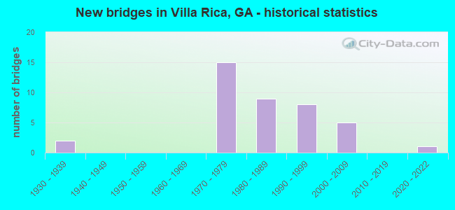
- New bridges - historical statistics
- 21930-1939
- 151970-1979
- 91980-1989
- 81990-1999
- 52000-2009
- 12020-2022
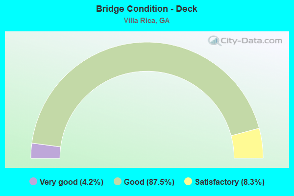
- Bridge Condition - Deck
- 4.2%Very good
- 87.5%Good
- 8.3%Satisfactory
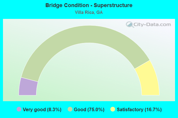
- Bridge Condition - Superstructure
- 8.3%Very good
- 75.0%Good
- 16.7%Satisfactory
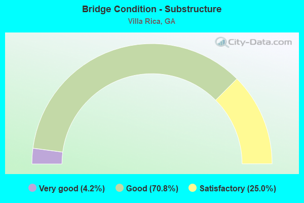
- Bridge Condition - Substructure
- 4.2%Very good
- 70.8%Good
- 25.0%Satisfactory
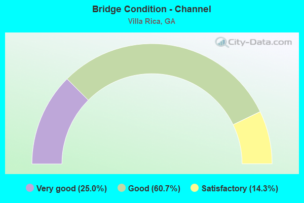
- Bridge Condition - Channel
- 25.0%Very good
- 60.7%Good
- 14.3%Satisfactory
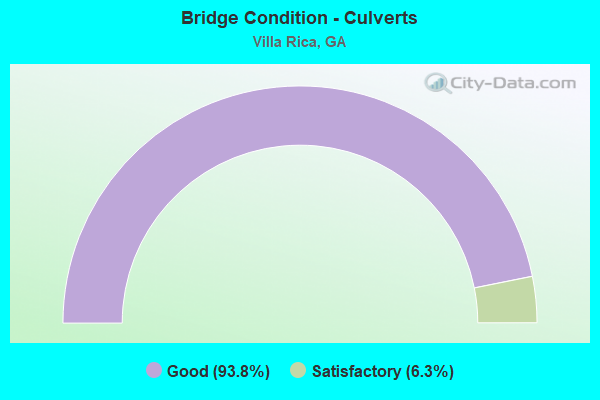
- Bridge Condition - Culverts
- 93.8%Good
- 6.3%Satisfactory
Find on map >> Show street view
Structure Number: 970017, Location: 7.8 MI W OF DOUGLASVILLE (Lat: 33.721558, Lng: -84.879000), Route carried "under" structure: Interstate 20, Structure Length: 0. m, Average Daily Traffic: 30,365 (year 2009), Truck Traffic: 1%, Features Intersected: CR 247 TYSON ROAD, Facility Carried by Structure: TYSON ROAD
Minimum Vertical Clearance: 5.71m (18.73ft), Kilometerpoint: 43.452, Lanes on structure: 2, Length of Maximum Span: 0.0m
Find on map >> Show street view
Structure Number: 970018, Location: 7.8 MI W OF DOUGLASVILLE (Lat: 33.723058, Lng: -84.879158), Route carried "under" structure: Interstate 20, Structure Length: 0. m, Average Daily Traffic: 30,365 (year 2009), Truck Traffic: 1%, Features Intersected: CR 247 TYSON ROAD, Facility Carried by Structure: TYSON ROAD
Minimum Vertical Clearance: 5.38m (17.65ft), Kilometerpoint: 43.452, Lanes on structure: 2, Length of Maximum Span: 0.0m
Find on map >> Show street view
Structure Number: 970034, Location: 5.5 MI WEST OF DOUGLASVIL (Lat: 33.718989, Lng: -84.832789), Route carried "under" structure: Interstate 20, Structure Length: 0. m, Average Daily Traffic: 53,200 (year 2009), Truck Traffic: 1%, Features Intersected: FAS 2278 POST ROAD, Facility Carried by Structure: POST ROAD
Minimum Vertical Clearance: 5.48m (17.98ft), Kilometerpoint: 48.280, Lanes on structure: 3, Length of Maximum Span: 0.0m
Find on map >> Show street view
Structure Number: 970041, Location: IN EAST VILLA RICA (Lat: 33.724839, Lng: -84.900750), Route carried "under" structure: Interstate 20, Structure Length: 0. m, Average Daily Traffic: 60,730 (year 1998), Truck Traffic: 1%, Features Intersected: FAS 2876 LIBERTY ROAD, Facility Carried by Structure: LIBERTY ROAD
Minimum Vertical Clearance: 6.22m (20.41ft), Kilometerpoint: 41.843, Lanes on structure: 2, Length of Maximum Span: 0.0m
Find on map >> Show street view
Structure Number: 975059, Location: 0.1 MI E OF VILLA RICA CL (Lat: 33.728786, Lng: -84.900067), Route carried "under" structure: State highway 8, Structure Length: 0. m, Average Daily Traffic: 9,600 (year 2001), Truck Traffic: 3%, Features Intersected: S-2876 LIBERTY ROAD, Facility Carried by Structure: LIBERTY ROAD
Minimum Vertical Clearance: 6.93m (22.74ft), Kilometerpoint: 1.609, Lanes on structure: 2, Length of Maximum Span: 0.0m