Bridge Statistics for Vincennes, Indiana (IN)
Condition, Traffic, Stress, Structural Evaluation, Project Costs
- National Bridge Inventory (NBI) Statistics
- 109Number of bridges
- 1,286ft / 392mTotal length
- $6,799,000Total costs
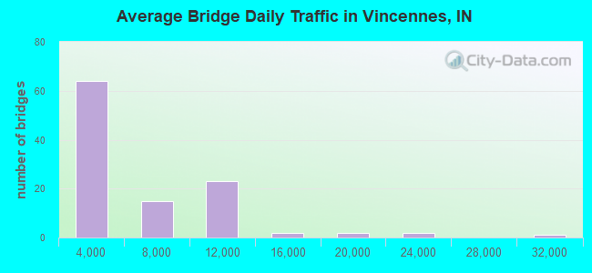
- 535,938Total average daily traffic
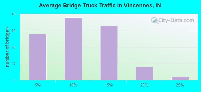
- 50,013Total average daily truck traffic
- National Bridge Inventory (NBI) Registered Bridges for Vincennes
- No street view available for this location
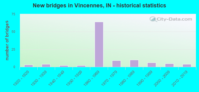
- New bridges - historical statistics
- 31920-1929
- 41930-1939
- 21940-1949
- 21950-1959
- 641960-1969
- 91970-1979
- 101980-1989
- 61990-1999
- 52000-2009
- 42010-2019
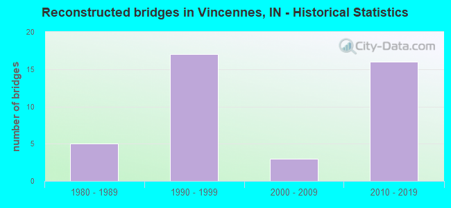
- Reconstructed bridges - Historical Statistics
- 51980-1989
- 171990-1999
- 32000-2009
- 162010-2019

- Bridge Condition - Deck
- 4.2%Very good
- 52.1%Good
- 39.4%Satisfactory
- 4.2%Fair
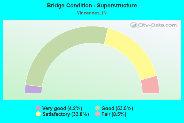
- Bridge Condition - Superstructure
- 4.2%Very good
- 53.5%Good
- 33.8%Satisfactory
- 8.5%Fair
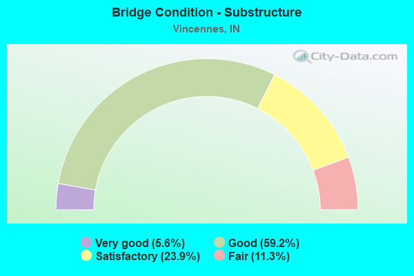
- Bridge Condition - Substructure
- 5.6%Very good
- 59.2%Good
- 23.9%Satisfactory
- 11.3%Fair
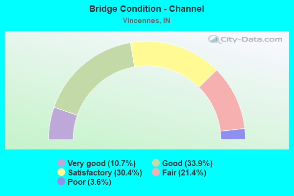
- Bridge Condition - Channel
- 10.7%Very good
- 33.9%Good
- 30.4%Satisfactory
- 21.4%Fair
- 3.6%Poor
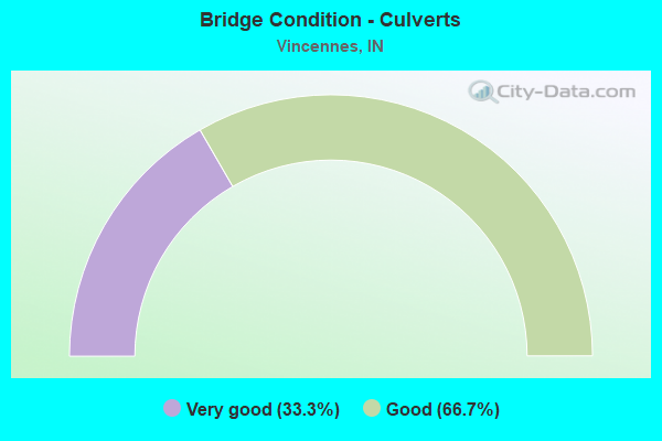
- Bridge Condition - Culverts
- 33.3%Very good
- 66.7%Good
Find on map >> Show street view
Structure Number: 1466, Location: 01.16 N SR 441 (Lat: 38.659881, Lng: -87.512550), Route carried "under" structure: City street , Year Built: 1967, Structure Length: 0. m, Average Daily Traffic: 118 (year 2004), Truck Traffic: 10%, Features Intersected: MAIN STREET ROAD, Facility Carried by Structure: US 41 SB
Minimum Vertical Clearance: 4.55m (14.93ft), Kilometerpoint: 0.000, Lanes on structure: 3, Lanes under structure: 2, Material/Design: Concrete continuous, Design/Construction: Slab, Length of Maximum Span: 13.1m (43.0ft)
Find on map >> Show street view
Structure Number: 1467, Location: 01.38 N SR 441 (Lat: 38.661811, Lng: -87.509422), Route carried "under" structure: US 41, Year Built: 1967, Structure Length: 0. m, Average Daily Traffic: 10,422 (year 2014), Truck Traffic: 12%, Features Intersected: US 41 SB, Facility Carried by Structure: HART STREET
Minimum Vertical Clearance: 4.42m (14.50ft), Kilometerpoint: 20.825, Lanes on structure: 5, Lanes under structure: 2, Material/Design: Steel continuous, Design/Construction: Stringer/Multi-beam, Length of Maximum Span: 18.5m (60.7ft)
Find on map >> Show street view
Structure Number: 1467, Location: 01.38 N SR 441 (Lat: 38.661811, Lng: -87.509422), Route carried "under" structure: US 41, Year Built: 1967, Structure Length: 0. m, Average Daily Traffic: 10,422 (year 2014), Truck Traffic: 12%, Features Intersected: US 41 NB, Facility Carried by Structure: HART STREET
Minimum Vertical Clearance: 4.42m (14.50ft), Kilometerpoint: 20.825, Lanes on structure: 5, Lanes under structure: 2, Material/Design: Steel continuous, Design/Construction: Stringer/Multi-beam, Length of Maximum Span: 18.5m (60.7ft)
Find on map >> Show street view
Structure Number: 147, Location: 01.20 S US 50 (Lat: 38.678419, Lng: -87.487786), Route carried "under" structure: Ramp US 41, Year Built: 1967, Structure Length: 0. m, Average Daily Traffic: 11,254 (year 2004), Truck Traffic: 5%, Features Intersected: US 50 WB RAMP
Minimum Vertical Clearance: 4.83m (15.85ft), Kilometerpoint: 4.892, Lanes on structure: 2, Lanes under structure: 2, Material/Design: Steel continuous, Design/Construction: Stringer/Multi-beam, Length of Maximum Span: 16.6m (54.5ft)
Find on map >> Show street view
Structure Number: 1471, Location: 00.44 S US 50 (Lat: 38.688911, Lng: -87.491006), Route carried "under" structure: City street , Year Built: 1961, Structure Length: 0. m, Average Daily Traffic: 60 (year 2004), Truck Traffic: 10%, Features Intersected: WASHINGTON AVENUE, Facility Carried by Structure: US 41 NB
Minimum Vertical Clearance: 8.10m (26.57ft), Kilometerpoint: 0.000, Lanes on structure: 2, Lanes under structure: 4, Material/Design: Steel continuous, Design/Construction: Stringer/Multi-beam, Length of Maximum Span: 18.3m (60.0ft)
Find on map >> Show street view
Structure Number: 1471, Location: 00.44 S US 50 (Lat: 38.688911, Lng: -87.491006), Route carried "under" structure: City street , Year Built: 1961, Structure Length: 0. m, Average Daily Traffic: 60 (year 2004), Truck Traffic: 10%, Features Intersected: BRUCEVILLE ROAD, Facility Carried by Structure: US 41 NB
Minimum Vertical Clearance: 7.16m (23.49ft), Kilometerpoint: 0.000, Lanes on structure: 2, Lanes under structure: 4, Material/Design: Steel continuous, Design/Construction: Stringer/Multi-beam, Length of Maximum Span: 18.3m (60.0ft)
Find on map >> Show street view
Structure Number: 1472, Location: 00.44 S US 50 (Lat: 38.688939, Lng: -87.491342), Route carried "under" structure: City street , Year Built: 1961, Structure Length: 0. m, Average Daily Traffic: 60 (year 2004), Truck Traffic: 10%, Features Intersected: BRUCEVILLE ROAD, Facility Carried by Structure: US 41 SB
Minimum Vertical Clearance: 7.24m (23.75ft), Kilometerpoint: 0.000, Lanes on structure: 2, Lanes under structure: 4, Material/Design: Steel continuous, Design/Construction: Stringer/Multi-beam, Length of Maximum Span: 20.1m (65.9ft)
Find on map >> Show street view
Structure Number: 1472, Location: 00.44 S US 50 (Lat: 38.688939, Lng: -87.491342), Route carried "under" structure: City street , Year Built: 1961, Structure Length: 0. m, Average Daily Traffic: 60 (year 2004), Truck Traffic: 10%, Features Intersected: WASHINGTON AVENUE, Facility Carried by Structure: US 41 SB
Minimum Vertical Clearance: 8.46m (27.76ft), Kilometerpoint: 0.000, Lanes on structure: 2, Lanes under structure: 4, Material/Design: Steel continuous, Design/Construction: Stringer/Multi-beam, Length of Maximum Span: 20.1m (65.9ft)
Find on map >> Show street view
Structure Number: 1473, Location: 00.72 N US 50 (Lat: 38.701731, Lng: -87.483933), Route carried "under" structure: US 41, Year Built: 1963, Structure Length: 0. m, Average Daily Traffic: 9,180 (year 2006), Truck Traffic: 10%, Features Intersected: US 41 SB, Facility Carried by Structure: HILLCREST RD
Minimum Vertical Clearance: 5.13m (16.83ft), Kilometerpoint: 26.619, Lanes on structure: 2, Lanes under structure: 2, Material/Design: Steel continuous, Design/Construction: Stringer/Multi-beam, Length of Maximum Span: 18.0m (59.1ft)
Find on map >> Show street view
Structure Number: 1473, Location: 00.72 N US 50 (Lat: 38.701731, Lng: -87.483933), Route carried "under" structure: US 41, Year Built: 1963, Structure Length: 0. m, Average Daily Traffic: 9,180 (year 2006), Truck Traffic: 10%, Features Intersected: US 41 NB, Facility Carried by Structure: HILLCREST RD
Minimum Vertical Clearance: 5.08m (16.67ft), Kilometerpoint: 26.619, Lanes on structure: 2, Lanes under structure: 2, Material/Design: Steel continuous, Design/Construction: Stringer/Multi-beam, Length of Maximum Span: 18.0m (59.1ft)
Find on map >> Show street view
Structure Number: 1814, Location: 01.85 W US 41 (Lat: 38.707161, Lng: -87.518897), Route carried "under" structure: State highway 33, Year Built: 1960, Structure Length: 0. m, Average Daily Traffic: 115 (year 2004), Truck Traffic: 10%, Features Intersected: Ill SR-33, Facility Carried by Structure: US 50 EB
Minimum Vertical Clearance: 9.02m (29.59ft), Kilometerpoint: 0.000, Lanes on structure: 2, Lanes under structure: 2, Material/Design: Steel continuous, Design/Construction: Girder and Floorbeam System, Length of Maximum Span: 45.7m (149.9ft)
Find on map >> Show street view
Structure Number: 1815, Location: 01.85 W US 41 (Lat: 38.707419, Lng: -87.518936), Route carried "under" structure: State highway 33, Year Built: 1960, Structure Length: 0. m, Average Daily Traffic: 115 (year 2004), Truck Traffic: 10%, Features Intersected: ILL SR-33, Facility Carried by Structure: US 50 WB
Minimum Vertical Clearance: 9.02m (29.59ft), Kilometerpoint: 0.000, Lanes on structure: 2, Lanes under structure: 2, Material/Design: Steel continuous, Design/Construction: Girder and Floorbeam System, Length of Maximum Span: 45.7m (149.9ft)
Find on map >> Show street view
Structure Number: 1816, Location: 01.24 W US 41 (Lat: 38.707519, Lng: -87.507561), Route carried "under" structure: County highway , Year Built: 1961, Structure Length: 0. m, Average Daily Traffic: 132 (year 2004), Truck Traffic: 10%, Features Intersected: FT KNOX ROAD, Facility Carried by Structure: US 50 EB
Minimum Vertical Clearance: 7.19m (23.59ft), Kilometerpoint: 0.000, Lanes on structure: 2, Lanes under structure: 2, Material/Design: Steel continuous, Design/Construction: Stringer/Multi-beam, Length of Maximum Span: 19.2m (63.0ft)
Find on map >> Show street view
Structure Number: 1817, Location: 01.24 W US 41 (Lat: 38.707750, Lng: -87.507636), Route carried "under" structure: County highway , Year Built: 1961, Structure Length: 0. m, Average Daily Traffic: 132 (year 2004), Truck Traffic: 10%, Features Intersected: FT KNOX ROAD, Facility Carried by Structure: US 50 WB
Minimum Vertical Clearance: 7.26m (23.82ft), Kilometerpoint: 0.000, Lanes on structure: 2, Lanes under structure: 2, Material/Design: Steel continuous, Design/Construction: Stringer/Multi-beam, Length of Maximum Span: 19.2m (63.0ft)
Find on map >> Show street view
Structure Number: 1818, Location: 00.59 W US 41 (Lat: 38.702719, Lng: -87.497392), Route carried "under" structure: US 50, Year Built: 1961, Structure Length: 0. m, Average Daily Traffic: 7,594 (year 2004), Truck Traffic: 16%, Features Intersected: US-50 EBL, Facility Carried by Structure: OLD SR 67
Minimum Vertical Clearance: 5.13m (16.83ft), Kilometerpoint: 2.028, Lanes on structure: 2, Lanes under structure: 4, Material/Design: Steel continuous, Design/Construction: Stringer/Multi-beam, Length of Maximum Span: 22.6m (74.1ft)
Find on map >> Show street view
Structure Number: 1818, Location: 00.59 W US 41 (Lat: 38.702719, Lng: -87.497392), Route carried "under" structure: US 50, Year Built: 1961, Structure Length: 0. m, Average Daily Traffic: 7,594 (year 2004), Truck Traffic: 16%, Features Intersected: US-50 WBL, Facility Carried by Structure: OLD SR 67
Minimum Vertical Clearance: 5.11m (16.77ft), Kilometerpoint: 2.028, Lanes on structure: 2, Lanes under structure: 4, Material/Design: Steel continuous, Design/Construction: Stringer/Multi-beam, Length of Maximum Span: 22.6m (74.1ft)
Find on map >> Show street view
Structure Number: 1821, Location: 00.13 W US 41 (Lat: 38.696700, Lng: -87.494164), Route carried "under" structure: US 50, Year Built: 1961, Structure Length: 0. m, Average Daily Traffic: 2,841 (year 2015), Truck Traffic: 15%, Features Intersected: US 50 WB, Facility Carried by Structure: HILLCREST RD
Minimum Vertical Clearance: 4.98m (16.34ft), Kilometerpoint: 2.768, Lanes on structure: 2, Lanes under structure: 2, Material/Design: Steel continuous, Design/Construction: Stringer/Multi-beam, Length of Maximum Span: 24.4m (80.1ft)
Find on map >> Show street view
Structure Number: 1821, Location: 00.13 W US 41 (Lat: 38.696700, Lng: -87.494164), Route carried "under" structure: US 50, Year Built: 1961, Structure Length: 0. m, Average Daily Traffic: 2,841 (year 2015), Truck Traffic: 15%, Features Intersected: US 50 EB, Facility Carried by Structure: HILLCREST RD
Minimum Vertical Clearance: 5.00m (16.40ft), Kilometerpoint: 2.768, Lanes on structure: 2, Lanes under structure: 3, Material/Design: Steel continuous, Design/Construction: Stringer/Multi-beam, Length of Maximum Span: 24.4m (80.1ft)
Find on map >> Show street view
Structure Number: 1821, Location: 00.13 W US 41 (Lat: 38.696700, Lng: -87.494164), Route carried "under" structure: Ramp US 50, Year Built: 1961, Structure Length: 0. m, Average Daily Traffic: 1,500 (year 2004), Truck Traffic: 10%, Features Intersected: US 50 WB RAMP, Facility Carried by Structure: HILLCREST RD
Minimum Vertical Clearance: 5.05m (16.57ft), Kilometerpoint: 2.768, Lanes on structure: 2, Lanes under structure: 1, Material/Design: Steel continuous, Design/Construction: Stringer/Multi-beam, Length of Maximum Span: 24.4m (80.1ft)
Find on map >> Show street view
Structure Number: 1822, Location: 01.20 W US 41 (Lat: 38.694850, Lng: -87.493628), Route carried "under" structure: US 41, Year Built: 1961, Structure Length: 0. m, Average Daily Traffic: 10,580 (year 2004), Truck Traffic: 10%, Features Intersected: US-41 SBL (6TH STR SBL), Facility Carried by Structure: US 50 EB
Minimum Vertical Clearance: 5.49m (18.01ft), Kilometerpoint: 25.444, Lanes on structure: 3, Lanes under structure: 6, Material/Design: Steel continuous, Design/Construction: Stringer/Multi-beam, Length of Maximum Span: 16.2m (53.1ft)
Find on map >> Show street view
Structure Number: 1822, Location: 01.20 W US 41 (Lat: 38.694850, Lng: -87.493628), Route carried "under" structure: City street , Year Built: 1961, Structure Length: 0. m, Average Daily Traffic: 10,580 (year 2004), Truck Traffic: 10%, Features Intersected: 6TH STREET NBL, Facility Carried by Structure: US 50 EB
Minimum Vertical Clearance: 5.49m (18.01ft), Kilometerpoint: 25.444, Lanes on structure: 3, Lanes under structure: 6, Material/Design: Steel continuous, Design/Construction: Stringer/Multi-beam, Length of Maximum Span: 16.2m (53.1ft)
Find on map >> Show street view
Structure Number: 1823, Location: 01.20 W US 41 (Lat: 38.695000, Lng: -87.493325), Route carried "under" structure: US 41, Year Built: 1961, Structure Length: 0. m, Average Daily Traffic: 10,580 (year 2004), Truck Traffic: 10%, Features Intersected: US-41 SBL (6TH STR SBL), Facility Carried by Structure: US 50 WB
Minimum Vertical Clearance: 5.18m (16.99ft), Kilometerpoint: 25.460, Lanes on structure: 3, Lanes under structure: 6, Material/Design: Steel continuous, Design/Construction: Stringer/Multi-beam, Length of Maximum Span: 16.2m (53.1ft)
Find on map >> Show street view
Structure Number: 1823, Location: 01.20 W US 41 (Lat: 38.695000, Lng: -87.493325), Route carried "under" structure: City street , Year Built: 1961, Structure Length: 0. m, Average Daily Traffic: 10,580 (year 2004), Truck Traffic: 10%, Features Intersected: 6TH STREET NBL, Facility Carried by Structure: US 50 WB
Minimum Vertical Clearance: 5.49m (18.01ft), Kilometerpoint: 25.460, Lanes on structure: 3, Lanes under structure: 6, Material/Design: Steel continuous, Design/Construction: Stringer/Multi-beam, Length of Maximum Span: 16.2m (53.1ft)
Find on map >> Show street view
Structure Number: 1824, Location: 01.20 E US 41 (Lat: 38.678489, Lng: -87.487717), Route carried "under" structure: US 41, Year Built: 1967, Structure Length: 0. m, Average Daily Traffic: 11,254 (year 2004), Truck Traffic: 10%, Features Intersected: US-41 NBL (MIDDLE), Facility Carried by Structure: US 50 EB (TOP)
Minimum Vertical Clearance: 4.72m (15.49ft), Kilometerpoint: 23.513, Lanes on structure: 2, Lanes under structure: 2, Material/Design: Steel continuous, Design/Construction: Stringer/Multi-beam, Length of Maximum Span: 26.5m (86.9ft)
Find on map >> Show street view
Structure Number: 1824, Location: 01.20 E US 41 (Lat: 38.678489, Lng: -87.487717), Route carried "under" structure: US 50, Year Built: 1967, Structure Length: 0. m, Average Daily Traffic: 8,720 (year 2004), Truck Traffic: 10%, Features Intersected: 50WBL TO 41SBL (BOTTOM)
Minimum Vertical Clearance: 4.83m (15.85ft), Kilometerpoint: 23.513, Lanes on structure: 2, Lanes under structure: 2, Material/Design: Steel continuous, Design/Construction: Stringer/Multi-beam, Length of Maximum Span: 26.5m (86.9ft)
Find on map >> Show street view
Structure Number: 2184, Location: 02.07 S US 50 (Lat: 38.669469, Lng: -87.498597), Route carried "under" structure: US 41, Year Built: 1967, Structure Length: 0. m, Average Daily Traffic: 11,253 (year 2004), Truck Traffic: 15%, Features Intersected: US-41 NBL, Facility Carried by Structure: OLD SR 61
Minimum Vertical Clearance: 4.98m (16.34ft), Kilometerpoint: 22.112, Lanes on structure: 2, Lanes under structure: 4, Material/Design: Steel continuous, Design/Construction: Stringer/Multi-beam, Length of Maximum Span: 18.7m (61.4ft)
Find on map >> Show street view
Structure Number: 2184, Location: 02.07 S US 50 (Lat: 38.669469, Lng: -87.498597), Route carried "under" structure: US 41, Year Built: 1967, Structure Length: 0. m, Average Daily Traffic: 11,253 (year 2004), Truck Traffic: 15%, Features Intersected: US-41 SBL, Facility Carried by Structure: OLD SR 61
Minimum Vertical Clearance: 4.95m (16.24ft), Kilometerpoint: 22.112, Lanes on structure: 2, Lanes under structure: 4, Material/Design: Steel continuous, Design/Construction: Stringer/Multi-beam, Length of Maximum Span: 18.7m (61.4ft)
Find on map >> Show street view
Structure Number: 2369, Location: 05.06 S SR 550 (Lat: 38.712969, Lng: -87.483758), Route carried "under" structure: US 41, Year Built: 1963, Structure Length: 0. m, Average Daily Traffic: 3,538 (year 2016), Truck Traffic: 10%, Features Intersected: US 41 NB
Minimum Vertical Clearance: 4.93m (16.17ft), Kilometerpoint: 27.890, Lanes on structure: 2, Lanes under structure: 2, Material/Design: Steel continuous, Design/Construction: Stringer/Multi-beam, Length of Maximum Span: 28.1m (92.2ft)
Find on map >> Show street view
Structure Number: 2369, Location: 05.06 S SR 550 (Lat: 38.712969, Lng: -87.483758), Route carried "under" structure: US 41, Year Built: 1963, Structure Length: 0. m, Average Daily Traffic: 3,538 (year 2016), Truck Traffic: 10%, Features Intersected: US 41 SB
Minimum Vertical Clearance: 5.16m (16.93ft), Kilometerpoint: 27.890, Lanes on structure: 2, Lanes under structure: 2, Material/Design: Steel continuous, Design/Construction: Stringer/Multi-beam, Length of Maximum Span: 28.1m (92.2ft)
Find on map >> Show street view
Structure Number: 3267, Location: 02.43 N US 41 (Lat: 38.681469, Lng: -87.535225), Route carried "under" structure: City street , Year Built: 1931, Structure Length: 0. m, Average Daily Traffic: 118 (year 2004), Truck Traffic: 10%, Features Intersected: LOCAL RD-ILLINOIS, Facility Carried by Structure: SR 441
Minimum Vertical Clearance: 5.16m (16.93ft), Kilometerpoint: 0.000, Lanes on structure: 2, Lanes under structure: 2, Material/Design: Concrete, Design/Construction: Arch - Deck, Length of Maximum Span: 54.9m (180.1ft)