Bridge Statistics for Vinton, Louisiana (LA)
Condition, Traffic, Stress, Structural Evaluation, Project Costs
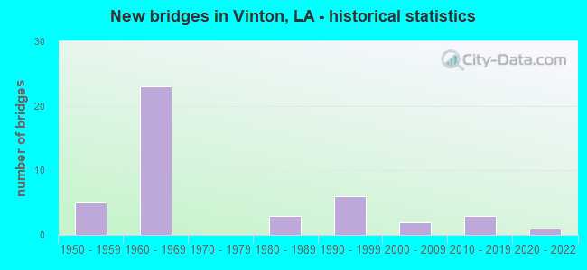
- New bridges - historical statistics
- 51950-1959
- 231960-1969
- 31980-1989
- 61990-1999
- 22000-2009
- 32010-2019
- 12020-2022


- Bridge Condition - Deck
- 2.9%Excellent
- 8.8%Very good
- 20.6%Good
- 58.8%Satisfactory
- 8.8%Fair

- Bridge Condition - Superstructure
- 2.9%Excellent
- 8.8%Very good
- 26.5%Good
- 52.9%Satisfactory
- 8.8%Fair

- Bridge Condition - Substructure
- 8.8%Very good
- 55.9%Good
- 23.5%Satisfactory
- 8.8%Fair
- 2.9%Poor

- Bridge Condition - Channel
- 9.8%Very good
- 36.6%Good
- 41.5%Satisfactory
- 9.8%Fair
- 2.4%Poor

- Bridge Condition - Culverts
- 55.6%Good
- 44.4%Satisfactory
Find on map >> Show street view
Structure Number: 71000000000161, Location: 1.2 MI W OF LA 108 (Lat: 30.139500, Lng: -93.554450), Route carried "on" structure: County highway , Year Built: 2019, Status: Open, Structure Length: 2.44m (8.01ft), Average Daily Traffic: 83 (year 2017), Average Future Daily Traffic: 90 (year 2025), Design Load: Greater than HL93, Features Intersected: GOBBLER CREEK, Facility Carried by Structure: JOHNNY BREAU RD
Minimum Vertical Clearance: 30+ m (98+ ft), Kilometerpoint: 3.100, Lanes on structure: 2, Owner: County Highway Agency, Approaching Roadway Width: 7.6m (24.9ft), Skew: 1 degrees, Material/Design: Concrete, Design/Construction: Slab, Number Of Spans In Main Unit: 4, Length of Maximum Span: 6.1m (20.0ft), Curb or Sidewalk Widths: Left: 1.5m (4.9ft), Right: 1.5m (4.9ft), Curb-To-Curb Width: 8.9m (29.2ft), Out-to-Out Width: 9.9m (32.5ft)
Condition: Deck: Good, Superstructure: Good, Substructure: Good, Channel: Very good, Operating Rating: 59.9 metric tons, Method Used To Determine Operating Rating: Load and Resistance Factor Rating (LRFR) rating reported by rating factor(RF) method using HL-93 loadings, Inventory Rating: 46.3 metric tons, Method Used To Determine Inventory Rating: Load and Resistance Factor Rating (LRFR) rating reported by rating factor(RF) method using HL-93 loadings, Structural Evaluation: Better than present minimum criteria, Deck Geometry: Better than present minimum criteria, Waterway Adequacy: Equal to present desirable criteria, Approach Roadway Alignment: Equal to present desirable criteria, Designated Inspection Frequency: Every 24 months, Inspection Date: July 2021, Deck Structure Type: Concrete Cast-file-Place
Find on map >> Show street view
Structure Number: 71000000070222, Location: 0.01 MI. E OF GUM COVE RD (Lat: 30.188811, Lng: -93.570369), Route carried "on" structure: County highway , Year Built: 2011, Status: Open, Structure Length: 3.20m (10.50ft), Average Daily Traffic: 60 (year 2019), Average Future Daily Traffic: 66 (year 2036), Design Load: HS 20, Features Intersected: HAMPTON COULEE, Facility Carried by Structure: WILLIAMS ST
Minimum Vertical Clearance: 30+ m (98+ ft), Kilometerpoint: 0.000, Lanes on structure: 2, Owner: Town or Township Highway Agency, Approaching Roadway Width: 7.0m (23.0ft), Skew: 30 degrees, Material/Design: Concrete, Design/Construction: Slab, Number Of Spans In Main Unit: 5, Length of Maximum Span: 7.6m (24.9ft), Curb or Sidewalk Widths: Left: 1.7m (5.6ft), Right: 0.0m, Curb-To-Curb Width: 8.9m (29.2ft), Out-to-Out Width: 11.5m (37.7ft)
Condition: Deck: Satisfactory, Superstructure: Satisfactory, Substructure: Satisfactory, Channel: Very good, Operating Rating: 49.6 metric tons, Method Used To Determine Operating Rating: Load and Resistance Factor Rating (LRFR) rating reported by rating factor(RF) method using HL-93 loadings, Inventory Rating: 38.2 metric tons, Method Used To Determine Inventory Rating: Load and Resistance Factor Rating (LRFR) rating reported by rating factor(RF) method using HL-93 loadings, Structural Evaluation: Equal to present minimum criteria, Deck Geometry: Better than present minimum criteria, Waterway Adequacy: Equal to present desirable criteria, Approach Roadway Alignment: Equal to present desirable criteria, Designated Inspection Frequency: Every 24 months, Inspection Date: December 2021, Deck Structure Type: Concrete Precast Panels, Wearing Surface/Protective System: Wearing Surface: Monolithic Concrete
Find on map >> Show street view
Structure Number: 71000000071007, Location: 0.5 MI N OF US 90 (Lat: 30.198769, Lng: -93.581369), Route carried "on" structure: City street , Year Built: 2020, Status: Open, Structure Length: 2.29m (7.51ft), Average Daily Traffic: 1,118 (year 2019), Average Future Daily Traffic: 1,230 (year 2039), Design Load: Greater than HL93, Features Intersected: GUM CREEK, Facility Carried by Structure: HORRIDGE STREET
Minimum Vertical Clearance: 30+ m (98+ ft), Kilometerpoint: 2.042, Lanes on structure: 2, Owner: Town or Township Highway Agency, Approaching Roadway Width: 6.3m (20.7ft), Material/Design: Concrete, Design/Construction: Slab, Number Of Spans In Main Unit: 3, Length of Maximum Span: 7.6m (24.9ft), Curb or Sidewalk Widths: Left: 1.6m (5.2ft), Right: 0.0m, Curb-To-Curb Width: 9.0m (29.5ft), Out-to-Out Width: 11.4m (37.4ft)
Condition: Deck: Excellent, Superstructure: Excellent, Substructure: Very good, Channel: Very good, Operating Rating: 55.4 metric tons, Method Used To Determine Operating Rating: Load and Resistance Factor Rating (LRFR) rating reported by rating factor(RF) method using HL-93 loadings, Inventory Rating: 42.8 metric tons, Method Used To Determine Inventory Rating: Load and Resistance Factor Rating (LRFR) rating reported by rating factor(RF) method using HL-93 loadings, Structural Evaluation: Equal to present desirable criteria, Deck Geometry: Somewhat better than minimum adequacy, Waterway Adequacy: Equal to present desirable criteria, Approach Roadway Alignment: Equal to present desirable criteria, Designated Inspection Frequency: Every 24 months, Inspection Date: November 2020, Deck Structure Type: Concrete Cast-file-Place
Find on map >> Show street view
Structure Number: 71000000500189, Location: 0.41 MILES SOUTH OF HWY 9 (Lat: 30.184719, Lng: -93.581400), Route carried "on" structure: County highway , Year Built: 2013, Status: Open, Structure Length: 2.29m (7.51ft), Average Daily Traffic: 3,374 (year 2019), Truck Traffic: 5%, Average Future Daily Traffic: 1,687 (year 2036), Design Load: HS 20, Features Intersected: VINTON DRAINAGE DITCH, Facility Carried by Structure: HORRIDGE ST
Minimum Vertical Clearance: 30+ m (98+ ft), Kilometerpoint: 0.000, Lanes on structure: 2, Owner: Town or Township Highway Agency, Approaching Roadway Width: 6.7m (22.0ft), Skew: 30 degrees, Material/Design: Concrete, Design/Construction: Slab, Number Of Spans In Main Unit: 3, Length of Maximum Span: 7.6m (24.9ft), Curb or Sidewalk Widths: Left: 0.0m, Right: 1.8m (5.9ft), Curb-To-Curb Width: 8.8m (28.9ft), Out-to-Out Width: 11.4m (37.4ft)
Condition: Deck: Very good, Superstructure: Very good, Substructure: Very good, Channel: Good, Operating Rating: 49.9 metric tons, Method Used To Determine Operating Rating: Load and Resistance Factor Rating (LRFR) rating reported by rating factor(RF) method using HL-93 loadings, Inventory Rating: 38.6 metric tons, Method Used To Determine Inventory Rating: Load and Resistance Factor Rating (LRFR) rating reported by rating factor(RF) method using HL-93 loadings, Structural Evaluation: Equal to present desirable criteria, Deck Geometry: Meets minimum limits, Waterway Adequacy: Superior to present desirable criteria, Approach Roadway Alignment: Superior to present desirable criteria, Designated Inspection Frequency: Every 24 months, Inspection Date: May 2020, Deck Structure Type: Concrete Precast Panels, Wearing Surface/Protective System: Wearing Surface: Monolithic Concrete
Find on map >> Show street view
Structure Number: 71000030200001, Location: US 90 OVER I-10 (Lat: 30.154181, Lng: -93.638319), Route carried "on" structure: US 90, Year Built: 1966, Status: Open, Structure Length: 7.68m (25.20ft), Average Daily Traffic: 1,910 (year 2016), Truck Traffic: 17%, Average Future Daily Traffic: 1,152 (year 2036), Design Load: HS 20, Features Intersected: I-10
Minimum Vertical Clearance: 30+ m (98+ ft), Kilometerpoint: 0.449, Lanes on structure: 2, Lanes under structure: 4, Owner: State Highway Agency, Approaching Roadway Width: 9.8m (32.2ft), Material/Design: Steel, Design/Construction: Stringer/Multi-beam, Number Of Spans In Main Unit: 4, Length of Maximum Span: 25.9m (85.0ft), Curb-To-Curb Width: 7.4m (24.3ft), Out-to-Out Width: 8.9m (29.2ft)
Condition: Deck: Satisfactory, Superstructure: Good, Substructure: Good, Operating Rating: 53.5 metric tons, Method Used To Determine Operating Rating: Load Factor (LF), Inventory Rating: 31.7 metric tons, Method Used To Determine Inventory Rating: Load Factor (LF), Structural Evaluation: Better than present minimum criteria, Deck Geometry: Meets minimum limits, Underclear: Somewhat better than minimum adequacy, Approach Roadway Alignment: Better than present minimum criteria, Designated Inspection Frequency: Every 24 months, Inspection Date: November 2020, Deck Structure Type: Concrete Cast-file-Place
Find on map >> Show street view
Structure Number: 71000030201401, Location: 1.4 MI NORTH OF I-10 (Lat: 30.166839, Lng: -93.625000), Route carried "on" structure: US 90, Year Built: 1954, Status: Open, Structure Length: 1.13m (3.71ft), Average Daily Traffic: 1,910 (year 2016), Truck Traffic: 17%, Average Future Daily Traffic: 1,152 (year 2036), Design Load: HS 20, Features Intersected: GUM GULLY
Minimum Vertical Clearance: 30+ m (98+ ft), Kilometerpoint: 2.536, Lanes on structure: 2, Owner: State Highway Agency, Approaching Roadway Width: 11.0m (36.1ft), Skew: 4 degrees, Material/Design: Concrete, Design/Construction: Culvert, Number Of Spans In Main Unit: 4, Length of Maximum Span: 2.4m (7.9ft), Curb-To-Curb Width: 11.0m (36.1ft), Out-to-Out Width: 18.5m (60.7ft)
Condition: Channel: Fair, Culverts: Good, Operating Rating: 42.1 metric tons, Method Used To Determine Operating Rating: Load and Resistance Factor Rating (LRFR) rating reported by rating factor(RF) method using HL-93 loadings, Inventory Rating: 32.4 metric tons, Method Used To Determine Inventory Rating: Load and Resistance Factor Rating (LRFR) rating reported by rating factor(RF) method using HL-93 loadings, Structural Evaluation: Better than present minimum criteria, Deck Geometry: Equal to present minimum criteria, Waterway Adequacy: Meets minimum limits, Approach Roadway Alignment: Equal to present desirable criteria, Designated Inspection Frequency: Every 24 months, Inspection Date: August 2020, Deck Structure Type: Concrete Cast-file-Place
Find on map >> Show street view
Structure Number: 71000030300581, Location: .58 MI EAST OF LA 3063 (Lat: 30.195500, Lng: -93.573300), Route carried "on" structure: US 90, Year Built: 1954, Status: Open, Structure Length: 2.44m (8.01ft), Average Daily Traffic: 2,100 (year 2016), Truck Traffic: 17%, Average Future Daily Traffic: 2,210 (year 2036), Design Load: HS 20, Features Intersected: HAMPTONS COULEE
Minimum Vertical Clearance: 30+ m (98+ ft), Kilometerpoint: 0.916, Lanes on structure: 2, Owner: State Highway Agency, Approaching Roadway Width: 11.0m (36.1ft), Material/Design: Concrete, Design/Construction: Slab, Number Of Spans In Main Unit: 4, Length of Maximum Span: 6.1m (20.0ft), Curb-To-Curb Width: 8.5m (27.9ft), Out-to-Out Width: 9.8m (32.2ft)
Condition: Deck: Satisfactory, Superstructure: Satisfactory, Substructure: Satisfactory, Channel: Satisfactory, Operating Rating: 26.2 metric tons, Method Used To Determine Operating Rating: Load and Resistance Factor Rating (LRFR) rating reported by rating factor(RF) method using HL-93 loadings, Inventory Rating: 20.4 metric tons, Method Used To Determine Inventory Rating: Load and Resistance Factor Rating (LRFR) rating reported by rating factor(RF) method using HL-93 loadings, Structural Evaluation: Somewhat better than minimum adequacy, Deck Geometry: Meets minimum limits, Waterway Adequacy: Equal to present desirable criteria, Approach Roadway Alignment: Better than present minimum criteria, Designated Inspection Frequency: Every 24 months, Inspection Date: August 2020, Deck Structure Type: Concrete Cast-file-Place, Wearing Surface/Protective System: Wearing Surface: Bituminous
Find on map >> Show street view
Structure Number: 71000030301481, Location: 1.48 MI EAST OF LA 3063 (Lat: 30.202489, Lng: -93.560700), Route carried "on" structure: US 90, Year Built: 1954, Status: Open, Structure Length: 2.44m (8.01ft), Average Daily Traffic: 6,400 (year 2016), Truck Traffic: 17%, Average Future Daily Traffic: 3,600 (year 2036), Design Load: HS 20, Features Intersected: COONE GULLY
Minimum Vertical Clearance: 30+ m (98+ ft), Kilometerpoint: 2.358, Lanes on structure: 2, Owner: State Highway Agency, Approaching Roadway Width: 11.0m (36.1ft), Material/Design: Concrete, Design/Construction: Slab, Number Of Spans In Main Unit: 4, Length of Maximum Span: 6.1m (20.0ft), Curb-To-Curb Width: 8.5m (27.9ft), Out-to-Out Width: 9.8m (32.2ft)
Condition: Deck: Satisfactory, Superstructure: Satisfactory, Substructure: Satisfactory, Channel: Good, Operating Rating: 26.2 metric tons, Method Used To Determine Operating Rating: Load and Resistance Factor Rating (LRFR) rating reported by rating factor(RF) method using HL-93 loadings, Inventory Rating: 20.4 metric tons, Method Used To Determine Inventory Rating: Load and Resistance Factor Rating (LRFR) rating reported by rating factor(RF) method using HL-93 loadings, Structural Evaluation: Somewhat better than minimum adequacy, Deck Geometry: High priority of replacement, Waterway Adequacy: Better than present minimum criteria, Approach Roadway Alignment: Better than present minimum criteria, Length Of Structure Improvement: 3.23m (10.60ft), Designated Inspection Frequency: Every 24 months, Inspection Date: August 2020, Bridge Improvement Cost: $275,000, Total Project Cost: $412,000 ( Estimate for 2016), Deck Structure Type: Concrete Cast-file-Place, Wearing Surface/Protective System: Wearing Surface: Bituminous
Find on map >> Show street view
Structure Number: 71000030302481, Location: 2.48 MI EAST OF LA 3063 (Lat: 30.210400, Lng: -93.546400), Route carried "on" structure: US 90, Year Built: 1954, Status: Open, Structure Length: 1.10m (3.61ft), Average Daily Traffic: 6,400 (year 2016), Truck Traffic: 17%, Average Future Daily Traffic: 3,600 (year 2036), Design Load: HS 20, Features Intersected: DRAIN
Minimum Vertical Clearance: 30+ m (98+ ft), Kilometerpoint: 3.986, Lanes on structure: 2, Owner: State Highway Agency, Approaching Roadway Width: 11.0m (36.1ft), Material/Design: Concrete, Design/Construction: Culvert, Number Of Spans In Main Unit: 7, Length of Maximum Span: 1.5m (4.9ft), Curb-To-Curb Width: 9.1m (29.9ft), Out-to-Out Width: 14.3m (46.9ft)
Condition: Channel: Satisfactory, Culverts: Satisfactory, Operating Rating: 42.1 metric tons, Method Used To Determine Operating Rating: Load and Resistance Factor Rating (LRFR) rating reported by rating factor(RF) method using HL-93 loadings, Inventory Rating: 32.4 metric tons, Method Used To Determine Inventory Rating: Load and Resistance Factor Rating (LRFR) rating reported by rating factor(RF) method using HL-93 loadings, Structural Evaluation: Equal to present minimum criteria, Deck Geometry: High priority of corrective action, Waterway Adequacy: Better than present minimum criteria, Approach Roadway Alignment: Equal to present desirable criteria, Length Of Structure Improvement: 1.74m (5.71ft), Designated Inspection Frequency: Every 24 months, Inspection Date: August 2020, Bridge Improvement Cost: $148,000, Total Project Cost: $222,000 ( Estimate for 2016), Deck Structure Type: Concrete Cast-file-Place
Find on map >> Show street view
Structure Number: 71000030304221, Location: 4.22 MI EAST OF LA 3063 (Lat: 30.223911, Lng: -93.522000), Route carried "on" structure: US 90, Year Built: 1954, Status: Open, Structure Length: 1.43m (4.69ft), Average Daily Traffic: 6,400 (year 2016), Truck Traffic: 17%, Average Future Daily Traffic: 3,600 (year 2036), Design Load: HS 20, Features Intersected: BAYOU
Minimum Vertical Clearance: 30+ m (98+ ft), Kilometerpoint: 6.772, Lanes on structure: 2, Owner: State Highway Agency, Approaching Roadway Width: 11.0m (36.1ft), Skew: 31 degrees, Material/Design: Concrete, Design/Construction: Culvert, Number Of Spans In Main Unit: 6, Length of Maximum Span: 2.1m (6.9ft)
Condition: Channel: Fair, Culverts: Satisfactory, Operating Rating: 42.1 metric tons, Method Used To Determine Operating Rating: Load and Resistance Factor Rating (LRFR) rating reported by rating factor(RF) method using HL-93 loadings, Inventory Rating: 32.4 metric tons, Method Used To Determine Inventory Rating: Load and Resistance Factor Rating (LRFR) rating reported by rating factor(RF) method using HL-93 loadings, Structural Evaluation: Equal to present minimum criteria, Waterway Adequacy: Better than present minimum criteria, Approach Roadway Alignment: Equal to present desirable criteria, Designated Inspection Frequency: Every 24 months, Inspection Date: September 2020, Deck Structure Type: Concrete Cast-file-Place
Find on map >> Show street view
Structure Number: 71001870105171, Location: 2.6 MI NORTH OF LA 3063 (Lat: 30.234300, Lng: -93.639100), Route carried "on" structure: State highway 109, Year Built: 1996, Status: Open, Structure Length: 2.44m (8.01ft), Average Daily Traffic: 2,100 (year 2016), Truck Traffic: 17%, Average Future Daily Traffic: 2,310 (year 2036), Design Load: HS 20, Features Intersected: SLOUGH
Minimum Vertical Clearance: 30+ m (98+ ft), Kilometerpoint: 8.287, Lanes on structure: 2, Owner: State Highway Agency, Approaching Roadway Width: 7.9m (25.9ft), Material/Design: Concrete, Design/Construction: Slab, Number Of Spans In Main Unit: 4, Length of Maximum Span: 6.1m (20.0ft), Curb-To-Curb Width: 11.1m (36.4ft), Out-to-Out Width: 13.1m (43.0ft)
Condition: Deck: Very good, Superstructure: Very good, Substructure: Very good, Channel: Good, Operating Rating: 77.1 metric tons, Method Used To Determine Operating Rating: Load Factor (LF), Inventory Rating: 46.3 metric tons, Method Used To Determine Inventory Rating: Load Factor (LF), Structural Evaluation: Equal to present desirable criteria, Deck Geometry: Somewhat better than minimum adequacy, Waterway Adequacy: Equal to present desirable criteria, Approach Roadway Alignment: Equal to present desirable criteria, Designated Inspection Frequency: Every 24 months, Inspection Date: September 2020, Deck Structure Type: Concrete Cast-file-Place
Find on map >> Show street view
Structure Number: 71001920100101, Location: LA 108 OVER I-10 (Lat: 30.185111, Lng: -93.568900), Route carried "on" structure: State highway 108, Year Built: 1966, Status: Open, Structure Length: 15.61m (51.21ft), Average Daily Traffic: 3,300 (year 2016), Truck Traffic: 17%, Average Future Daily Traffic: 1,008 (year 2036), Design Load: HS 20, Features Intersected: I-10
Minimum Vertical Clearance: 30+ m (98+ ft), Kilometerpoint: 0.225, Lanes on structure: 2, Lanes under structure: 4, Owner: State Highway Agency, Approaching Roadway Width: 40.2m (131.9ft), Skew: 4 degrees, Material/Design: Steel, Design/Construction: Stringer/Multi-beam, Number Of Spans In Main Unit: 7, Length of Maximum Span: 33.5m (109.9ft), Curb-To-Curb Width: 8.5m (27.9ft), Out-to-Out Width: 10.2m (33.5ft)
Condition: Deck: Satisfactory, Superstructure: Good, Substructure: Good, Channel: Good, Operating Rating: 56.2 metric tons, Method Used To Determine Operating Rating: Load Factor (LF), Inventory Rating: 33.6 metric tons, Method Used To Determine Inventory Rating: Load Factor (LF), Structural Evaluation: Better than present minimum criteria, Deck Geometry: Meets minimum limits, Underclear: Somewhat better than minimum adequacy, Waterway Adequacy: Better than present minimum criteria, Approach Roadway Alignment: Better than present minimum criteria, Designated Inspection Frequency: Every 24 months, Inspection Date: November 2020, Deck Structure Type: Concrete Cast-file-Place
Find on map >> Show street view
Structure Number: 71001920100751, Location: .65 MI SOUTH OF I-10 (Lat: 30.183861, Lng: -93.560300), Route carried "on" structure: State highway 108, Year Built: 2006, Status: Open, Structure Length: 3.60m (11.81ft), Average Daily Traffic: 1,450 (year 2016), Truck Traffic: 17%, Average Future Daily Traffic: 474 (year 2036), Design Load: HS 20, Features Intersected: COON GULLY
Minimum Vertical Clearance: 30+ m (98+ ft), Kilometerpoint: 1.077, Lanes on structure: 2, Owner: State Highway Agency, Approaching Roadway Width: 9.1m (29.9ft), Material/Design: Prestressed concrete continuous, Design/Construction: Stringer/Multi-beam, Number Of Spans In Main Unit: 3, Length of Maximum Span: 11.9m (39.0ft), Curb-To-Curb Width: 9.0m (29.5ft), Out-to-Out Width: 9.8m (32.2ft)
Condition: Deck: Very good, Superstructure: Very good, Substructure: Good, Channel: Good, Operating Rating: 40.2 metric tons, Method Used To Determine Operating Rating: Load and Resistance Factor Rating (LRFR) rating reported by rating factor(RF) method using HL-93 loadings, Inventory Rating: 30.8 metric tons, Method Used To Determine Inventory Rating: Load and Resistance Factor Rating (LRFR) rating reported by rating factor(RF) method using HL-93 loadings, Structural Evaluation: Better than present minimum criteria, Deck Geometry: Somewhat better than minimum adequacy, Waterway Adequacy: Equal to present desirable criteria, Approach Roadway Alignment: Equal to present desirable criteria, Designated Inspection Frequency: Every 24 months, Inspection Date: March 2021, Deck Structure Type: Concrete Cast-file-Place
Find on map >> Show street view
Structure Number: 71001920102961, Location: 2.96 MI SOUTH OF I-10 (Lat: 30.168761, Lng: -93.538600), Route carried "on" structure: State highway 108, Year Built: 1961, Status: Open, Structure Length: 0.70m (2.30ft), Average Daily Traffic: 1,450 (year 2016), Truck Traffic: 17%, Average Future Daily Traffic: 474 (year 2036), Design Load: H 15, Features Intersected: DRAIN
Minimum Vertical Clearance: 30+ m (98+ ft), Kilometerpoint: 4.562, Lanes on structure: 5, Owner: State Highway Agency, Approaching Roadway Width: 9.8m (32.2ft), Material/Design: Concrete, Design/Construction: Culvert, Number Of Spans In Main Unit: 2, Length of Maximum Span: 3.0m (9.8ft), Curb-To-Curb Width: 9.8m (32.2ft), Out-to-Out Width: 10.4m (34.1ft)
Condition: Channel: Satisfactory, Culverts: Satisfactory, Operating Rating: 31.1 metric tons, Method Used To Determine Operating Rating: Load and Resistance Factor Rating (LRFR) rating reported by rating factor(RF) method using HL-93 loadings, Inventory Rating: 24.0 metric tons, Method Used To Determine Inventory Rating: Load and Resistance Factor Rating (LRFR) rating reported by rating factor(RF) method using HL-93 loadings, Structural Evaluation: Equal to present minimum criteria, Deck Geometry: High priority of replacement, Waterway Adequacy: Equal to present desirable criteria, Approach Roadway Alignment: Better than present minimum criteria, Length Of Structure Improvement: 1.31m (4.30ft), Designated Inspection Frequency: Every 24 months, Inspection Date: March 2021, Bridge Improvement Cost: $111,000, Total Project Cost: $166,000 ( Estimate for 2016), Deck Structure Type: Concrete Cast-file-Place
Find on map >> Show street view
Structure Number: 71001920104711, Location: 4.71 MI SOUTH OF I-10 (Lat: 30.144069, Lng: -93.536389), Route carried "on" structure: State highway 108, Year Built: 1961, Status: Open, Structure Length: 0.85m (2.79ft), Average Daily Traffic: 1,450 (year 2016), Truck Traffic: 17%, Average Future Daily Traffic: 474 (year 2036), Design Load: H 15, Features Intersected: BAYOU
Minimum Vertical Clearance: 30+ m (98+ ft), Kilometerpoint: 7.368, Lanes on structure: 2, Owner: State Highway Agency, Approaching Roadway Width: 9.8m (32.2ft), Skew: 4 degrees, Material/Design: Concrete, Design/Construction: Culvert, Number Of Spans In Main Unit: 3, Length of Maximum Span: 1.8m (5.9ft), Curb-To-Curb Width: 9.8m (32.2ft), Out-to-Out Width: 10.4m (34.1ft)
Condition: Channel: Satisfactory, Culverts: Satisfactory, Operating Rating: 22.7 metric tons, Method Used To Determine Operating Rating: Load and Resistance Factor Rating (LRFR) rating reported by rating factor(RF) method using HL-93 loadings, Inventory Rating: 17.5 metric tons, Method Used To Determine Inventory Rating: Load and Resistance Factor Rating (LRFR) rating reported by rating factor(RF) method using HL-93 loadings, Structural Evaluation: Meets minimum limits, Deck Geometry: Somewhat better than minimum adequacy, Waterway Adequacy: Equal to present desirable criteria, Approach Roadway Alignment: Equal to present desirable criteria, Designated Inspection Frequency: Every 24 months, Inspection Date: March 2021, Deck Structure Type: Concrete Cast-file-Place
Find on map >> Show street view
Structure Number: 71004509104901, Location: 1.0 MI EAST OF LA 109 (Lat: 30.161150, Lng: -93.622600), Route carried "on" structure: Interstate 10, Year Built: 1966, Status: Open, Structure Length: 3.05m (10.01ft), Average Daily Traffic: 25,550 (year 2016), Truck Traffic: 34%, Average Future Daily Traffic: 17,064 (year 2036), Design Load: HS 20, Features Intersected: GUM GULLY
Minimum Vertical Clearance: 30+ m (98+ ft), Kilometerpoint: 7.622, Lanes on structure: 2, Base Highway Network: Yes (Inventory Route: 450-91-1, Subroute: 10), Owner: State Highway Agency, Approaching Roadway Width: 11.6m (38.1ft), Skew: 10 degrees, Material/Design: Concrete, Design/Construction: Slab, Number Of Spans In Main Unit: 5, Length of Maximum Span: 6.1m (20.0ft), Curb-To-Curb Width: 12.2m (40.0ft), Out-to-Out Width: 13.9m (45.6ft)
Condition: Deck: Satisfactory, Superstructure: Satisfactory, Substructure: Good, Channel: Satisfactory, Operating Rating: 53.5 metric tons, Method Used To Determine Operating Rating: Load Factor (LF), Inventory Rating: 32.7 metric tons, Method Used To Determine Inventory Rating: Load Factor (LF), Structural Evaluation: Equal to present minimum criteria, Deck Geometry: Better than present minimum criteria, Waterway Adequacy: Equal to present desirable criteria, Approach Roadway Alignment: Equal to present desirable criteria, Designated Inspection Frequency: Every 24 months, Inspection Date: November 2020, Deck Structure Type: Concrete Cast-file-Place
Find on map >> Show street view
Structure Number: 71004509104902, Location: 1.0 MI EAST OF LA 109 (Lat: 30.161469, Lng: -93.622400), Route carried "on" structure: Interstate 10, Year Built: 1966, Status: Open, Structure Length: 3.05m (10.01ft), Average Daily Traffic: 25,550 (year 2016), Truck Traffic: 34%, Average Future Daily Traffic: 17,064 (year 2036), Design Load: HS 20, Features Intersected: GUM GULLY
Minimum Vertical Clearance: 30+ m (98+ ft), Kilometerpoint: 62.380, Lanes on structure: 2, Base Highway Network: Yes (Inventory Route: 450-91-2, Subroute: 10), Owner: State Highway Agency, Approaching Roadway Width: 11.6m (38.1ft), Skew: 10 degrees, Material/Design: Concrete, Design/Construction: Slab, Number Of Spans In Main Unit: 5, Length of Maximum Span: 6.1m (20.0ft), Curb-To-Curb Width: 12.2m (40.0ft), Out-to-Out Width: 13.9m (45.6ft)
Condition: Deck: Satisfactory, Superstructure: Satisfactory, Substructure: Good, Channel: Satisfactory, Operating Rating: 53.5 metric tons, Method Used To Determine Operating Rating: Load Factor (LF), Inventory Rating: 32.7 metric tons, Method Used To Determine Inventory Rating: Load Factor (LF), Structural Evaluation: Equal to present minimum criteria, Deck Geometry: Better than present minimum criteria, Waterway Adequacy: Equal to present desirable criteria, Approach Roadway Alignment: Equal to present desirable criteria, Designated Inspection Frequency: Every 24 months, Inspection Date: November 2020, Deck Structure Type: Concrete Cast-file-Place
Find on map >> Show street view
Structure Number: 71004509108211, Location: .9 MI EAST OF LA 3063 (Lat: 30.182439, Lng: -93.573000), Route carried "on" structure: Interstate 10, Year Built: 1966, Status: Open, Structure Length: 7.32m (24.02ft), Average Daily Traffic: 25,400 (year 2016), Truck Traffic: 34%, Average Future Daily Traffic: 16,200 (year 2036), Design Load: HS 20, Features Intersected: VINTON CANAL
Minimum Vertical Clearance: 30+ m (98+ ft), Kilometerpoint: 12.946, Lanes on structure: 2, Base Highway Network: Yes (Inventory Route: 450-91-1, Subroute: 10), Owner: State Highway Agency, Approaching Roadway Width: 11.9m (39.0ft), Skew: 16 degrees, Material/Design: Concrete, Design/Construction: Slab, Number Of Spans In Main Unit: 12, Length of Maximum Span: 6.1m (20.0ft), Curb-To-Curb Width: 12.2m (40.0ft), Out-to-Out Width: 13.9m (45.6ft)
Condition: Deck: Satisfactory, Superstructure: Satisfactory, Substructure: Good, Channel: Satisfactory, Operating Rating: 70.7 metric tons, Method Used To Determine Operating Rating: Load Factor (LF), Inventory Rating: 42.6 metric tons, Method Used To Determine Inventory Rating: Load Factor (LF), Structural Evaluation: Equal to present minimum criteria, Deck Geometry: Better than present minimum criteria, Waterway Adequacy: Equal to present desirable criteria, Approach Roadway Alignment: Equal to present desirable criteria, Designated Inspection Frequency: Every 24 months, Inspection Date: November 2020, Deck Structure Type: Concrete Cast-file-Place
Find on map >> Show street view
Structure Number: 71004509108212, Location: .9 MI EAST OF LA 3063 (Lat: 30.182850, Lng: -93.572600), Route carried "on" structure: Interstate 10, Year Built: 1966, Status: Open, Structure Length: 7.32m (24.02ft), Average Daily Traffic: 25,400 (year 2016), Truck Traffic: 34%, Average Future Daily Traffic: 16,200 (year 2036), Design Load: HS 20, Features Intersected: VINTON CANAL
Minimum Vertical Clearance: 30+ m (98+ ft), Kilometerpoint: 57.032, Lanes on structure: 3, Base Highway Network: Yes (Inventory Route: 450-91-2, Subroute: 10), Owner: State Highway Agency, Approaching Roadway Width: 15.5m (50.9ft), Skew: 16 degrees, Material/Design: Concrete, Design/Construction: Slab, Number Of Spans In Main Unit: 12, Length of Maximum Span: 6.1m (20.0ft), Curb-To-Curb Width: 12.2m (40.0ft), Out-to-Out Width: 13.9m (45.6ft)
Condition: Deck: Satisfactory, Superstructure: Satisfactory, Substructure: Good, Channel: Fair, Operating Rating: 70.7 metric tons, Method Used To Determine Operating Rating: Load Factor (LF), Inventory Rating: 42.6 metric tons, Method Used To Determine Inventory Rating: Load Factor (LF), Structural Evaluation: Equal to present minimum criteria, Deck Geometry: High priority of corrective action, Waterway Adequacy: Equal to present desirable criteria, Approach Roadway Alignment: Equal to present desirable criteria, Length Of Structure Improvement: 8.23m (27.00ft), Designated Inspection Frequency: Every 24 months, Inspection Date: November 2020, Bridge Improvement Cost: $702,000, Total Project Cost: $1,053,000 ( Estimate for 2016), Deck Structure Type: Concrete Cast-file-Place
Find on map >> Show street view
Structure Number: 71004509108511, Location: 1.2 MI EAST OF LA 3063 (Lat: 30.184369, Lng: -93.568500), Route carried "on" structure: Interstate 10, Year Built: 1966, Status: Open, Structure Length: 4.27m (14.01ft), Average Daily Traffic: 25,400 (year 2016), Truck Traffic: 34%, Average Future Daily Traffic: 16,200 (year 2036), Design Load: HS 20, Features Intersected: HAMPTONS COULEE
Minimum Vertical Clearance: 30+ m (98+ ft), Kilometerpoint: 13.433, Lanes on structure: 2, Base Highway Network: Yes (Inventory Route: 450-91-1, Subroute: 10), Owner: State Highway Agency, Approaching Roadway Width: 11.6m (38.1ft), Skew: 10 degrees, Material/Design: Concrete, Design/Construction: Slab, Number Of Spans In Main Unit: 7, Length of Maximum Span: 6.1m (20.0ft), Curb-To-Curb Width: 12.2m (40.0ft), Out-to-Out Width: 14.0m (45.9ft)
Condition: Deck: Fair, Superstructure: Fair, Substructure: Good, Channel: Satisfactory, Operating Rating: 40.5 metric tons, Method Used To Determine Operating Rating: Load and Resistance Factor Rating (LRFR) rating reported by rating factor(RF) method using HL-93 loadings, Inventory Rating: 31.1 metric tons, Method Used To Determine Inventory Rating: Load and Resistance Factor Rating (LRFR) rating reported by rating factor(RF) method using HL-93 loadings, Structural Evaluation: Somewhat better than minimum adequacy, Deck Geometry: Better than present minimum criteria, Waterway Adequacy: Equal to present desirable criteria, Approach Roadway Alignment: Equal to present desirable criteria, Designated Inspection Frequency: Every 24 months, Underwater Inspection Frequency: Every 60 months, Inspection Date: November 2020, Underwater Inspection Date: Febuary 2019, Deck Structure Type: Concrete Cast-file-Place
Find on map >> Show street view
Structure Number: 71004509108512, Location: 1.2 MI EAST OF LA 3063 (Lat: 30.184761, Lng: -93.568200), Route carried "on" structure: Interstate 10, Year Built: 1966, Status: Open, Structure Length: 4.27m (14.01ft), Average Daily Traffic: 25,400 (year 2016), Truck Traffic: 34%, Average Future Daily Traffic: 16,200 (year 2036), Design Load: HS 20, Features Intersected: HAMPTONS COULEE
Minimum Vertical Clearance: 30+ m (98+ ft), Kilometerpoint: 56.556, Lanes on structure: 2, Base Highway Network: Yes (Inventory Route: 450-91-2, Subroute: 10), Owner: State Highway Agency, Approaching Roadway Width: 11.6m (38.1ft), Skew: 10 degrees, Material/Design: Concrete, Design/Construction: Slab, Number Of Spans In Main Unit: 7, Length of Maximum Span: 6.1m (20.0ft), Curb-To-Curb Width: 12.2m (40.0ft), Out-to-Out Width: 14.0m (45.9ft)
Condition: Deck: Fair, Superstructure: Fair, Substructure: Good, Channel: Satisfactory, Operating Rating: 40.5 metric tons, Method Used To Determine Operating Rating: Load and Resistance Factor Rating (LRFR) rating reported by rating factor(RF) method using HL-93 loadings, Inventory Rating: 31.1 metric tons, Method Used To Determine Inventory Rating: Load and Resistance Factor Rating (LRFR) rating reported by rating factor(RF) method using HL-93 loadings, Structural Evaluation: Somewhat better than minimum adequacy, Deck Geometry: Better than present minimum criteria, Waterway Adequacy: Equal to present desirable criteria, Approach Roadway Alignment: Equal to present desirable criteria, Designated Inspection Frequency: Every 24 months, Underwater Inspection Frequency: Every 60 months, Inspection Date: November 2020, Underwater Inspection Date: Febuary 2019, Deck Structure Type: Concrete Cast-file-Place
Find on map >> Show street view
Structure Number: 71004509108513, Location: 0.2 MI W OF LA 108 (Lat: 30.184019, Lng: -93.568269), Route carried "on" structure: ServiceInterstate 10, Year Built: 1981, Status: Open, Structure Length: 3.47m (11.38ft), Average Daily Traffic: 5,080 (year 2016), Truck Traffic: 17%, Average Future Daily Traffic: 5,660 (year 2036), Design Load: HS 20, Features Intersected: HAMPTON COULEE, Facility Carried by Structure: JOE COURVILLE RD.
Minimum Vertical Clearance: 30+ m (98+ ft), Kilometerpoint: 0.240, Lanes on structure: 2, Owner: State Highway Agency, Approaching Roadway Width: 10.4m (34.1ft), Skew: 30 degrees, Material/Design: Concrete, Design/Construction: Slab, Number Of Spans In Main Unit: 6, Length of Maximum Span: 5.8m (19.0ft), Curb-To-Curb Width: 7.3m (24.0ft), Out-to-Out Width: 8.3m (27.2ft)
Condition: Deck: Satisfactory, Superstructure: Satisfactory, Substructure: Good, Channel: Good, Operating Rating: 66.2 metric tons, Method Used To Determine Operating Rating: Load Factor (LF), Inventory Rating: 39.9 metric tons, Method Used To Determine Inventory Rating: Load Factor (LF), Structural Evaluation: Equal to present minimum criteria, Deck Geometry: High priority of replacement, Waterway Adequacy: Equal to present desirable criteria, Approach Roadway Alignment: Equal to present minimum criteria, Designated Inspection Frequency: Every 24 months, Underwater Inspection Frequency: Every 60 months, Inspection Date: July 2021, Underwater Inspection Date: Febuary 2019, Deck Structure Type: Concrete Precast Panels, Wearing Surface/Protective System: Wearing Surface: Monolithic Concrete
Find on map >> Show street view
Structure Number: 71004509108518, Location: 1.2 MI EAST OF LA 3063 (Lat: 30.185319, Lng: -93.568400), Route carried "on" structure: Ramp Interstate 10, Year Built: 1966, Status: Open, Structure Length: 4.27m (14.01ft), Average Daily Traffic: 5,080 (year 2016), Truck Traffic: 34%, Average Future Daily Traffic: 2,700 (year 2036), Design Load: HS 20, Features Intersected: HAMPTONS COULEE
Minimum Vertical Clearance: 30+ m (98+ ft), Kilometerpoint: 0.261, Lanes on structure: 1, Owner: State Highway Agency, Approaching Roadway Width: 9.1m (29.9ft), Material/Design: Concrete, Design/Construction: Slab, Number Of Spans In Main Unit: 7, Length of Maximum Span: 6.1m (20.0ft), Curb-To-Curb Width: 6.2m (20.3ft), Out-to-Out Width: 7.8m (25.6ft)
Condition: Deck: Satisfactory, Superstructure: Satisfactory, Substructure: Satisfactory, Channel: Poor, Operating Rating: 61.7 metric tons, Method Used To Determine Operating Rating: Load Factor (LF), Inventory Rating: 37.2 metric tons, Method Used To Determine Inventory Rating: Load Factor (LF), Structural Evaluation: Equal to present minimum criteria, Deck Geometry: Somewhat better than minimum adequacy, Waterway Adequacy: Better than present minimum criteria, Approach Roadway Alignment: Better than present minimum criteria, Designated Inspection Frequency: Every 24 months, Underwater Inspection Frequency: Every 60 months, Inspection Date: November 2020, Underwater Inspection Date: Febuary 2019, Deck Structure Type: Concrete Cast-file-Place
Find on map >> Show street view
Structure Number: 71004509109111, Location: .5 MI EAST OF LA 108 (Lat: 30.186839, Lng: -93.558900), Route carried "on" structure: Interstate 10, Year Built: 1965, Status: Open, Structure Length: 3.66m (12.01ft), Average Daily Traffic: 25,400 (year 2016), Truck Traffic: 34%, Average Future Daily Traffic: 16,200 (year 2036), Design Load: HS 20, Features Intersected: COONE GULLY
Minimum Vertical Clearance: 30+ m (98+ ft), Kilometerpoint: 14.397, Lanes on structure: 2, Base Highway Network: Yes (Inventory Route: 450-91-1, Subroute: 10), Owner: State Highway Agency, Approaching Roadway Width: 11.6m (38.1ft), Skew: 16 degrees, Material/Design: Concrete, Design/Construction: Slab, Number Of Spans In Main Unit: 6, Length of Maximum Span: 6.1m (20.0ft), Curb-To-Curb Width: 12.2m (40.0ft), Out-to-Out Width: 14.0m (45.9ft)
Condition: Deck: Satisfactory, Superstructure: Satisfactory, Substructure: Good, Channel: Satisfactory, Operating Rating: 69.8 metric tons, Method Used To Determine Operating Rating: Load Factor (LF), Inventory Rating: 41.7 metric tons, Method Used To Determine Inventory Rating: Load Factor (LF), Structural Evaluation: Equal to present minimum criteria, Deck Geometry: Better than present minimum criteria, Waterway Adequacy: Equal to present desirable criteria, Approach Roadway Alignment: Equal to present desirable criteria, Designated Inspection Frequency: Every 24 months, Inspection Date: October 2020, Deck Structure Type: Concrete Cast-file-Place
Find on map >> Show street view
Structure Number: 71004509109122, Location: .5 MI EAST OF LA 108 (Lat: 30.187461, Lng: -93.558500), Route carried "on" structure: Interstate 10, Year Built: 1965, Status: Open, Structure Length: 3.66m (12.01ft), Average Daily Traffic: 25,400 (year 2016), Truck Traffic: 34%, Average Future Daily Traffic: 16,200 (year 2036), Design Load: HS 20, Features Intersected: COONE GULLY
Minimum Vertical Clearance: 30+ m (98+ ft), Kilometerpoint: 55.567, Lanes on structure: 2, Base Highway Network: Yes (Inventory Route: 450-91-2, Subroute: 10), Owner: State Highway Agency, Approaching Roadway Width: 11.6m (38.1ft), Skew: 16 degrees, Material/Design: Concrete, Design/Construction: Slab, Number Of Spans In Main Unit: 6, Length of Maximum Span: 6.1m (20.0ft), Curb-To-Curb Width: 12.3m (40.4ft), Out-to-Out Width: 14.0m (45.9ft)
Condition: Deck: Satisfactory, Superstructure: Satisfactory, Substructure: Good, Channel: Satisfactory, Operating Rating: 69.8 metric tons, Method Used To Determine Operating Rating: Load Factor (LF), Inventory Rating: 41.7 metric tons, Method Used To Determine Inventory Rating: Load Factor (LF), Structural Evaluation: Equal to present minimum criteria, Deck Geometry: Better than present minimum criteria, Waterway Adequacy: Better than present minimum criteria, Approach Roadway Alignment: Equal to present desirable criteria, Designated Inspection Frequency: Every 24 months, Inspection Date: October 2020, Deck Structure Type: Concrete Cast-file-Place
Find on map >> Show street view
Structure Number: 71004509110861, Location: 2.3 MI EAST OF LA 108 (Lat: 30.192300, Lng: -93.530300), Route carried "on" structure: Interstate 10, Year Built: 1966, Status: Open, Structure Length: 0.82m (2.69ft), Average Daily Traffic: 25,400 (year 2016), Truck Traffic: 34%, Average Future Daily Traffic: 16,200 (year 2036), Design Load: HS 20, Features Intersected: DRAIN
Minimum Vertical Clearance: 30+ m (98+ ft), Kilometerpoint: 17.214, Lanes on structure: 2, Base Highway Network: Yes (Inventory Route: 450-91-1, Subroute: 10), Owner: State Highway Agency, Approaching Roadway Width: 18.9m (62.0ft), Skew: 11 degrees, Material/Design: Concrete, Design/Construction: Culvert, Number Of Spans In Main Unit: 3, Length of Maximum Span: 2.4m (7.9ft), Curb-To-Curb Width: 19.5m (64.0ft), Out-to-Out Width: 28.0m (91.9ft)
Condition: Channel: Satisfactory, Culverts: Good, Operating Rating: 42.1 metric tons, Method Used To Determine Operating Rating: Load and Resistance Factor Rating (LRFR) rating reported by rating factor(RF) method using HL-93 loadings, Inventory Rating: 32.4 metric tons, Method Used To Determine Inventory Rating: Load and Resistance Factor Rating (LRFR) rating reported by rating factor(RF) method using HL-93 loadings, Structural Evaluation: Better than present minimum criteria, Deck Geometry: Superior to present desirable criteria, Waterway Adequacy: Equal to present desirable criteria, Approach Roadway Alignment: Equal to present desirable criteria, Designated Inspection Frequency: Every 24 months, Inspection Date: November 2020, Deck Structure Type: Concrete Cast-file-Place
Find on map >> Show street view
Structure Number: 71004509110862, Location: 2.3 MI EAST OF LA 108 (Lat: 30.192881, Lng: -93.530300), Route carried "on" structure: Interstate 10, Year Built: 1966, Status: Open, Structure Length: 0.82m (2.69ft), Average Daily Traffic: 25,400 (year 2016), Truck Traffic: 34%, Average Future Daily Traffic: 16,200 (year 2036), Design Load: HS 20, Features Intersected: DRAIN
Minimum Vertical Clearance: 30+ m (98+ ft), Kilometerpoint: 52.786, Lanes on structure: 2, Base Highway Network: Yes (Inventory Route: 450-91-2, Subroute: 10), Owner: State Highway Agency, Approaching Roadway Width: 18.6m (61.0ft), Skew: 10 degrees, Material/Design: Concrete, Design/Construction: Culvert, Number Of Spans In Main Unit: 3, Length of Maximum Span: 2.7m (8.9ft), Curb-To-Curb Width: 19.2m (63.0ft), Out-to-Out Width: 27.8m (91.2ft)
Condition: Channel: Satisfactory, Culverts: Good, Operating Rating: 42.1 metric tons, Method Used To Determine Operating Rating: Load and Resistance Factor Rating (LRFR) rating reported by rating factor(RF) method using HL-93 loadings, Inventory Rating: 32.4 metric tons, Method Used To Determine Inventory Rating: Load and Resistance Factor Rating (LRFR) rating reported by rating factor(RF) method using HL-93 loadings, Structural Evaluation: Better than present minimum criteria, Deck Geometry: Superior to present desirable criteria, Waterway Adequacy: Equal to present desirable criteria, Approach Roadway Alignment: Equal to present desirable criteria, Designated Inspection Frequency: Every 24 months, Inspection Date: November 2020, Deck Structure Type: Concrete Cast-file-Place
Find on map >> Show street view
Structure Number: 71004509111871, Location: 3.3 MI EAST OF LA 108 (Lat: 30.195539, Lng: -93.513500), Route carried "on" structure: Interstate 10, Year Built: 1966, Status: Open, Structure Length: 0.85m (2.79ft), Average Daily Traffic: 50,800 (year 2016), Truck Traffic: 34%, Average Future Daily Traffic: 27,000 (year 2036), Design Load: HS 20, Features Intersected: SABINE CANAL
Minimum Vertical Clearance: 30+ m (98+ ft), Kilometerpoint: 18.873, Lanes on structure: 4, Base Highway Network: Yes (Inventory Route: 450-91-1, Subroute: 10), Owner: State Highway Agency, Approaching Roadway Width: 57.3m (188.0ft), Skew: 13 degrees, Material/Design: Concrete, Design/Construction: Culvert, Number Of Spans In Main Unit: 3, Length of Maximum Span: 2.4m (7.9ft), Curb-To-Curb Width: 23.2m (76.1ft), Out-to-Out Width: 97.2m (318.9ft)
Condition: Channel: Satisfactory, Culverts: Good, Operating Rating: 42.1 metric tons, Method Used To Determine Operating Rating: Load and Resistance Factor Rating (LRFR) rating reported by rating factor(RF) method using HL-93 loadings, Inventory Rating: 32.4 metric tons, Method Used To Determine Inventory Rating: Load and Resistance Factor Rating (LRFR) rating reported by rating factor(RF) method using HL-93 loadings, Structural Evaluation: Better than present minimum criteria, Deck Geometry: Superior to present desirable criteria, Waterway Adequacy: Somewhat better than minimum adequacy, Approach Roadway Alignment: Equal to present desirable criteria, Designated Inspection Frequency: Every 24 months, Inspection Date: November 2020, Deck Structure Type: Concrete Cast-file-Place
Find on map >> Show street view
Structure Number: 71008102503951, Location: 3.95 MI SE OF LA 109 (Lat: 30.185969, Lng: -93.587300), Route carried "on" structure: State highway 3063, Year Built: 1968, Status: Posted for load, Structure Length: 1.16m (3.81ft), Average Daily Traffic: 2,600 (year 2016), Truck Traffic: 17%, Average Future Daily Traffic: 2,860 (year 2036), Design Load: HS 20, Features Intersected: DRAINAGE DITCH
Minimum Vertical Clearance: 30+ m (98+ ft), Kilometerpoint: 6.284, Lanes on structure: 2, Owner: State Highway Agency, Approaching Roadway Width: 8.8m (28.9ft), Material/Design: Concrete, Design/Construction: Slab, Number Of Spans In Main Unit: 2, Length of Maximum Span: 5.8m (19.0ft), Curb or Sidewalk Widths: Left: 1.0m (3.3ft), Right: 1.0m (3.3ft), Curb-To-Curb Width: 8.7m (28.5ft), Out-to-Out Width: 10.5m (34.4ft)
Condition: Deck: Satisfactory, Superstructure: Satisfactory, Substructure: Poor, Channel: Satisfactory, Operating Rating: 19.1 metric tons, Method Used To Determine Operating Rating: Load and Resistance Factor Rating (LRFR) rating reported by rating factor(RF) method using HL-93 loadings, Inventory Rating: 13.0 metric tons, Method Used To Determine Inventory Rating: Load and Resistance Factor Rating (LRFR) rating reported by rating factor(RF) method using HL-93 loadings, Structural Evaluation: Meets minimum limits, Deck Geometry: Meets minimum limits, Waterway Adequacy: Equal to present desirable criteria, Approach Roadway Alignment: Equal to present desirable criteria, Bridge Posting: Required (Relationship of Operating Rating to Maximum Legal Load: 10.0 - 19.9% below), Length Of Structure Improvement: 1.80m (5.91ft), Designated Inspection Frequency: Every 24 months, Other Special Inspection Frequency: Every 12 months, Inspection Date: September 2020, Other Special Inspection Date: September 2021, Bridge Improvement Cost: $153,000, Total Project Cost: $229,000 ( Estimate for 2016), Deck Structure Type: Concrete Precast Panels, Wearing Surface/Protective System: Wearing Surface: Bituminous
Find on map >> Show street view
Structure Number: 71008102504621, Location: LA. 3063 OVER I-10 (Lat: 30.176819, Lng: -93.587200), Route carried "on" structure: County highway , Year Built: 1966, Status: Open, Structure Length: 7.38m (24.21ft), Average Daily Traffic: 2,600 (year 2016), Truck Traffic: 17%, Average Future Daily Traffic: 1,440 (year 2036), Design Load: HS 20, Features Intersected: I-10, Facility Carried by Structure: LA3063
Minimum Vertical Clearance: 30+ m (98+ ft), Kilometerpoint: 7.298, Lanes on structure: 2, Lanes under structure: 4, Owner: State Highway Agency, Approaching Roadway Width: 11.0m (36.1ft), Skew: 3 degrees, Material/Design: Steel, Design/Construction: Stringer/Multi-beam, Number Of Spans In Main Unit: 4, Length of Maximum Span: 24.4m (80.1ft), Curb-To-Curb Width: 8.5m (27.9ft), Out-to-Out Width: 10.2m (33.5ft)
Condition: Deck: Satisfactory, Superstructure: Good, Substructure: Good, Operating Rating: 57.1 metric tons, Method Used To Determine Operating Rating: Load Factor (LF), Inventory Rating: 33.6 metric tons, Method Used To Determine Inventory Rating: Load Factor (LF), Structural Evaluation: Better than present minimum criteria, Deck Geometry: Meets minimum limits, Underclear: Somewhat better than minimum adequacy, Approach Roadway Alignment: Better than present minimum criteria, Designated Inspection Frequency: Every 24 months, Inspection Date: November 2020, Deck Structure Type: Concrete Cast-file-Place
Find on map >> Show street view
Structure Number: 71030095933721, Location: 1.70 MI. E. OF INT. (Lat: 30.160919, Lng: -93.622519), Route carried "on" structure: County highway , Year Built: 1964, Status: Posted for load, Structure Length: 3.05m (10.01ft), Average Daily Traffic: 586 (year 2017), Average Future Daily Traffic: 69 (year 2036), Design Load: HS 20, Features Intersected: GUM GULLEY, Facility Carried by Structure: GRAY RD
Minimum Vertical Clearance: 30+ m (98+ ft), Kilometerpoint: 0.000, Lanes on structure: 2, Owner: County Highway Agency, Approaching Roadway Width: 9.1m (29.9ft), Material/Design: Concrete, Design/Construction: Slab, Number Of Spans In Main Unit: 5, Length of Maximum Span: 6.1m (20.0ft), Curb-To-Curb Width: 7.3m (24.0ft), Out-to-Out Width: 8.8m (28.9ft)
Condition: Deck: Satisfactory, Superstructure: Satisfactory, Substructure: Good, Channel: Satisfactory, Operating Rating: 26.6 metric tons, Method Used To Determine Operating Rating: Load and Resistance Factor Rating (LRFR) rating reported by rating factor(RF) method using HL-93 loadings, Inventory Rating: 20.4 metric tons, Method Used To Determine Inventory Rating: Load and Resistance Factor Rating (LRFR) rating reported by rating factor(RF) method using HL-93 loadings, Structural Evaluation: Somewhat better than minimum adequacy, Deck Geometry: Meets minimum limits, Waterway Adequacy: Equal to present desirable criteria, Approach Roadway Alignment: Better than present minimum criteria, Designated Inspection Frequency: Every 24 months, Inspection Date: November 2021, Deck Structure Type: Concrete Cast-file-Place, Wearing Surface/Protective System: Wearing Surface: Bituminous
Find on map >> Show street view
Structure Number: 71030096933401, Location: 2.2 MI EAST OF LA 108 (Lat: 30.161289, Lng: -93.567650), Route carried "on" structure: County highway , Year Built: 1991, Status: Open, Structure Length: 7.32m (24.02ft), Average Daily Traffic: 586 (year 2017), Average Future Daily Traffic: 77 (year 2036), Design Load: HS 20, Features Intersected: VINTON CANAL, Facility Carried by Structure: GRAY RD
Minimum Vertical Clearance: 30+ m (98+ ft), Kilometerpoint: 0.000, Lanes on structure: 2, Owner: County Highway Agency, Approaching Roadway Width: 8.5m (27.9ft), Material/Design: Prestressed concrete, Design/Construction: Stringer/Multi-beam, Number Of Spans In Main Unit: 5, Length of Maximum Span: 14.6m (47.9ft), Curb-To-Curb Width: 7.3m (24.0ft), Out-to-Out Width: 8.0m (26.2ft)
Condition: Deck: Good, Superstructure: Good, Substructure: Satisfactory, Channel: Good, Operating Rating: 46.7 metric tons, Method Used To Determine Operating Rating: Load and Resistance Factor Rating (LRFR) rating reported by rating factor(RF) method using HL-93 loadings, Inventory Rating: 34.0 metric tons, Method Used To Determine Inventory Rating: Load and Resistance Factor Rating (LRFR) rating reported by rating factor(RF) method using HL-93 loadings, Structural Evaluation: Equal to present minimum criteria, Deck Geometry: Meets minimum limits, Waterway Adequacy: Equal to present desirable criteria, Approach Roadway Alignment: Equal to present desirable criteria, Designated Inspection Frequency: Every 24 months, Underwater Inspection Frequency: Every 60 months, Inspection Date: November 2021, Underwater Inspection Date: Febuary 2019, Deck Structure Type: Concrete Cast-file-Place
Find on map >> Show street view
Structure Number: 71030110933231, Location: 0.4 MI EAST OF LA 108 (Lat: 30.183811, Lng: -93.536900), Route carried "on" structure: County highway , Year Built: 1999, Status: Open, Structure Length: 1.74m (5.71ft), Average Daily Traffic: 691 (year 2017), Average Future Daily Traffic: 120 (year 2036), Design Load: HS 20, Features Intersected: SABINE CANAL, Facility Carried by Structure: GUM ISLAND RD
Minimum Vertical Clearance: 30+ m (98+ ft), Kilometerpoint: 0.000, Lanes on structure: 2, Base Highway Network: Yes, Owner: County Highway Agency, Approaching Roadway Width: 8.2m (26.9ft), Material/Design: Concrete, Design/Construction: Slab, Number Of Spans In Main Unit: 3, Length of Maximum Span: 5.8m (19.0ft), Curb-To-Curb Width: 8.5m (27.9ft), Out-to-Out Width: 9.4m (30.8ft)
Condition: Deck: Satisfactory, Superstructure: Satisfactory, Substructure: Satisfactory, Channel: Very good, Operating Rating: 48.6 metric tons, Method Used To Determine Operating Rating: Load and Resistance Factor Rating (LRFR) rating reported by rating factor(RF) method using HL-93 loadings, Inventory Rating: 37.6 metric tons, Method Used To Determine Inventory Rating: Load and Resistance Factor Rating (LRFR) rating reported by rating factor(RF) method using HL-93 loadings, Structural Evaluation: Equal to present minimum criteria, Deck Geometry: Somewhat better than minimum adequacy, Waterway Adequacy: Equal to present desirable criteria, Approach Roadway Alignment: Equal to present desirable criteria, Designated Inspection Frequency: Every 24 months, Inspection Date: May 2020, Deck Structure Type: Concrete Precast Panels
Find on map >> Show street view
Structure Number: 71030117933871, Location: 0.5 MI WEST OF LA 109 (Lat: 30.193331, Lng: -93.645569), Route carried "on" structure: County highway , Year Built: 1998, Status: Open, Structure Length: 1.74m (5.71ft), Average Daily Traffic: 689 (year 2017), Average Future Daily Traffic: 120 (year 2036), Design Load: HS 20, Features Intersected: GUM SLOUGH, Facility Carried by Structure: NIBBLETS BLUFF RD
Minimum Vertical Clearance: 30+ m (98+ ft), Kilometerpoint: 0.000, Lanes on structure: 2, Base Highway Network: Yes, Owner: County Highway Agency, Approaching Roadway Width: 7.9m (25.9ft), Material/Design: Concrete, Design/Construction: Slab, Number Of Spans In Main Unit: 3, Length of Maximum Span: 5.8m (19.0ft), Curb-To-Curb Width: 8.6m (28.2ft), Out-to-Out Width: 9.5m (31.2ft)
Condition: Deck: Fair, Superstructure: Fair, Substructure: Fair, Channel: Good, Operating Rating: 38.9 metric tons, Method Used To Determine Operating Rating: Load and Resistance Factor Rating (LRFR) rating reported by rating factor(RF) method using HL-93 loadings, Inventory Rating: 30.1 metric tons, Method Used To Determine Inventory Rating: Load and Resistance Factor Rating (LRFR) rating reported by rating factor(RF) method using HL-93 loadings, Structural Evaluation: Somewhat better than minimum adequacy, Deck Geometry: Somewhat better than minimum adequacy, Waterway Adequacy: Equal to present desirable criteria, Approach Roadway Alignment: Meets minimum limits, Designated Inspection Frequency: Every 24 months, Inspection Date: November 2021, Deck Structure Type: Concrete Precast Panels
Find on map >> Show street view
Structure Number: 71030121933441, Location: 0.3 MI SOUTH OF US 90 (Lat: 30.185681, Lng: -93.583031), Route carried "on" structure: County highway , Year Built: 1968, Status: Posted for load, Structure Length: 1.16m (3.81ft), Average Daily Traffic: 207 (year 2019), Average Future Daily Traffic: 60 (year 2036), Design Load: HS 20, Features Intersected: GUM CREEK, Facility Carried by Structure: STEVENSON ST
Minimum Vertical Clearance: 30+ m (98+ ft), Kilometerpoint: 0.000, Lanes on structure: 2, Owner: City or Municipal Highway Agency, Approaching Roadway Width: 8.5m (27.9ft), Material/Design: Concrete, Design/Construction: Slab, Number Of Spans In Main Unit: 2, Length of Maximum Span: 5.8m (19.0ft), Curb or Sidewalk Widths: Left: 0.9m (3.0ft), Right: 0.9m (3.0ft), Curb-To-Curb Width: 8.6m (28.2ft), Out-to-Out Width: 10.8m (35.4ft)
Condition: Deck: Satisfactory, Superstructure: Satisfactory, Substructure: Fair, Channel: Satisfactory, Operating Rating: 28.5 metric tons, Method Used To Determine Operating Rating: Load and Resistance Factor Rating (LRFR) rating reported by rating factor(RF) method using HL-93 loadings, Inventory Rating: 22.0 metric tons, Method Used To Determine Inventory Rating: Load and Resistance Factor Rating (LRFR) rating reported by rating factor(RF) method using HL-93 loadings, Structural Evaluation: Somewhat better than minimum adequacy, Deck Geometry: Equal to present minimum criteria, Waterway Adequacy: Better than present minimum criteria, Approach Roadway Alignment: Equal to present desirable criteria, Designated Inspection Frequency: Every 24 months, Inspection Date: May 2020, Deck Structure Type: Concrete Precast Panels
Find on map >> Show street view
Structure Number: 71030122933441, Location: 0.2 MI EAST OF LA 3063 (Lat: 30.185800, Lng: -93.584350), Route carried "on" structure: County highway , Year Built: 1968, Status: Open, Structure Length: 1.16m (3.81ft), Average Daily Traffic: 100 (year 2019), Average Future Daily Traffic: 110 (year 2036), Design Load: HS 20, Features Intersected: FARMERS L & C CO. CANAL, Facility Carried by Structure: FANCHER ST
Minimum Vertical Clearance: 30+ m (98+ ft), Kilometerpoint: 0.000, Lanes on structure: 2, Owner: City or Municipal Highway Agency, Approaching Roadway Width: 8.5m (27.9ft), Material/Design: Concrete, Design/Construction: Slab, Number Of Spans In Main Unit: 2, Length of Maximum Span: 5.8m (19.0ft), Curb or Sidewalk Widths: Left: 0.9m (3.0ft), Right: 0.9m (3.0ft), Curb-To-Curb Width: 8.6m (28.2ft), Out-to-Out Width: 10.8m (35.4ft)
Condition: Deck: Satisfactory, Superstructure: Satisfactory, Substructure: Satisfactory, Channel: Good, Operating Rating: 81.6 metric tons, Method Used To Determine Operating Rating: Load Factor (LF), Inventory Rating: 40.8 metric tons, Method Used To Determine Inventory Rating: Load Factor (LF), Structural Evaluation: Equal to present minimum criteria, Deck Geometry: Better than present minimum criteria, Waterway Adequacy: Equal to present desirable criteria, Approach Roadway Alignment: Equal to present desirable criteria, Designated Inspection Frequency: Every 24 months, Inspection Date: May 2020, Deck Structure Type: Concrete Precast Panels
Find on map >> Show street view
Structure Number: 71030122933491, Location: 0.1 MI. E. of LA 3063 (Lat: 30.185800, Lng: -93.585781), Route carried "on" structure: County highway , Year Built: 1968, Status: Open, Structure Length: 1.16m (3.81ft), Average Future Daily Traffic: 60 (year 2036), Design Load: HS 20, Features Intersected: CANAL, Facility Carried by Structure: VINCENT ST
Minimum Vertical Clearance: 30+ m (98+ ft), Kilometerpoint: 0.238, Lanes on structure: 2, Owner: City or Municipal Highway Agency, Approaching Roadway Width: 9.1m (29.9ft), Material/Design: Concrete, Design/Construction: Slab, Number Of Spans In Main Unit: 2, Length of Maximum Span: 5.8m (19.0ft), Curb or Sidewalk Widths: Left: 0.9m (3.0ft), Right: 0.9m (3.0ft), Curb-To-Curb Width: 8.6m (28.2ft), Out-to-Out Width: 10.8m (35.4ft)
Condition: Deck: Satisfactory, Superstructure: Satisfactory, Substructure: Good, Channel: Good, Operating Rating: 25.9 metric tons, Method Used To Determine Operating Rating: Load and Resistance Factor Rating (LRFR) rating reported by rating factor(RF) method using HL-93 loadings, Inventory Rating: 19.8 metric tons, Method Used To Determine Inventory Rating: Load and Resistance Factor Rating (LRFR) rating reported by rating factor(RF) method using HL-93 loadings, Structural Evaluation: Somewhat better than minimum adequacy, Deck Geometry: Better than present minimum criteria, Waterway Adequacy: Equal to present desirable criteria, Approach Roadway Alignment: Equal to present desirable criteria, Length Of Structure Improvement: 1.80m (5.91ft), Designated Inspection Frequency: Every 24 months, Inspection Date: May 2020, Bridge Improvement Cost: $108,000, Total Project Cost: $162,000 ( Estimate for 2016), Deck Structure Type: Concrete Precast Panels
Find on map >> Show street view
Structure Number: 71030123934021, Location: .3 M N. LA 3063 (Lat: 30.203381, Lng: -93.587469), Route carried "on" structure: County highway , Year Built: 2000, Status: Open, Structure Length: 2.99m (9.81ft), Average Daily Traffic: 1,074 (year 2017), Average Future Daily Traffic: 390 (year 2036), Design Load: HS 20, Features Intersected: CANAL, Facility Carried by Structure: BIG WOODS RD
Minimum Vertical Clearance: 30+ m (98+ ft), Kilometerpoint: 0.000, Lanes on structure: 2, Owner: City or Municipal Highway Agency, Approaching Roadway Width: 7.3m (24.0ft), Material/Design: Concrete, Design/Construction: Slab, Number Of Spans In Main Unit: 5, Length of Maximum Span: 6.1m (20.0ft), Curb-To-Curb Width: 8.5m (27.9ft), Out-to-Out Width: 9.3m (30.5ft)
Condition: Deck: Good, Superstructure: Good, Substructure: Good, Channel: Good, Operating Rating: 33.4 metric tons, Method Used To Determine Operating Rating: Load and Resistance Factor Rating (LRFR) rating reported by rating factor(RF) method using HL-93 loadings, Inventory Rating: 25.9 metric tons, Method Used To Determine Inventory Rating: Load and Resistance Factor Rating (LRFR) rating reported by rating factor(RF) method using HL-93 loadings, Structural Evaluation: Equal to present minimum criteria, Deck Geometry: Somewhat better than minimum adequacy, Waterway Adequacy: Equal to present desirable criteria, Approach Roadway Alignment: Equal to present desirable criteria, Designated Inspection Frequency: Every 24 months, Inspection Date: May 2020, Deck Structure Type: Concrete Cast-file-Place
Find on map >> Show street view
Structure Number: 71030128933861, Location: 0.3 MI WEST OF LA 109 (Lat: 30.213069, Lng: -93.642069), Route carried "on" structure: County highway , Year Built: 1994, Status: Posted for load, Structure Length: 1.68m (5.51ft), Average Daily Traffic: 20 (year 2019), Average Future Daily Traffic: 42 (year 2036), Design Load: H 15, Features Intersected: GUM SLOUGH, Facility Carried by Structure: SPELL RD
Minimum Vertical Clearance: 30+ m (98+ ft), Kilometerpoint: 0.000, Lanes on structure: 2, Owner: County Highway Agency, Approaching Roadway Width: 7.3m (24.0ft), Material/Design: Wood or Timber, Design/Construction: Stringer/Multi-beam, Number Of Spans In Main Unit: 3, Length of Maximum Span: 5.8m (19.0ft), Curb-To-Curb Width: 7.6m (24.9ft), Out-to-Out Width: 8.0m (26.2ft)
Condition: Deck: Good, Superstructure: Satisfactory, Substructure: Fair, Channel: Good, Operating Rating: 22.7 metric tons, Method Used To Determine Operating Rating: Allowable Stress (AS), Inventory Rating: 15.4 metric tons, Method Used To Determine Inventory Rating: Allowable Stress (AS), Structural Evaluation: Meets minimum limits, Deck Geometry: Equal to present minimum criteria, Waterway Adequacy: Better than present minimum criteria, Approach Roadway Alignment: Meets minimum limits, Bridge Posting: Required (Relationship of Operating Rating to Maximum Legal Load: 10.0 - 19.9% below), Designated Inspection Frequency: Every 24 months, Inspection Date: May 2020, Deck Structure Type: Wood or Timber, Wearing Surface/Protective System: Wearing Surface: Wood or Timber
Find on map >> Show street view
Structure Number: 71030131933061, Location: 1.7 M NORTH OF I-10 (Lat: 30.217911, Lng: -93.511261), Route carried "on" structure: County highway , Year Built: 1990, Status: Open, Structure Length: 1.74m (5.71ft), Average Daily Traffic: 121 (year 2017), Average Future Daily Traffic: 84 (year 2036), Design Load: HS 20, Features Intersected: CANAL, Facility Carried by Structure: FABACHER RD
Minimum Vertical Clearance: 30+ m (98+ ft), Kilometerpoint: 0.000, Lanes on structure: 2, Owner: County Highway Agency, Approaching Roadway Width: 7.3m (24.0ft), Material/Design: Concrete, Design/Construction: Slab, Number Of Spans In Main Unit: 3, Length of Maximum Span: 5.8m (19.0ft), Curb-To-Curb Width: 7.4m (24.3ft), Out-to-Out Width: 8.2m (26.9ft)
Condition: Deck: Good, Superstructure: Good, Substructure: Satisfactory, Channel: Good, Operating Rating: 47.6 metric tons, Method Used To Determine Operating Rating: Load and Resistance Factor Rating (LRFR) rating reported by rating factor(RF) method using HL-93 loadings, Inventory Rating: 36.6 metric tons, Method Used To Determine Inventory Rating: Load and Resistance Factor Rating (LRFR) rating reported by rating factor(RF) method using HL-93 loadings, Structural Evaluation: Equal to present minimum criteria, Deck Geometry: Somewhat better than minimum adequacy, Waterway Adequacy: Equal to present desirable criteria, Approach Roadway Alignment: Equal to present desirable criteria, Designated Inspection Frequency: Every 24 months, Inspection Date: May 2020, Deck Structure Type: Concrete Cast-file-Place
Find on map >> Show street view
Structure Number: 71030136933861, Location: 0.3 MI WEST OF LA 109 (Lat: 30.227069, Lng: -93.644239), Route carried "on" structure: County highway , Year Built: 1986, Status: Open, Structure Length: 1.74m (5.71ft), Average Daily Traffic: 144 (year 2017), Average Future Daily Traffic: 129 (year 2036), Design Load: HS 20, Features Intersected: GUM SLOUGH, Facility Carried by Structure: LINE RD
Minimum Vertical Clearance: 30+ m (98+ ft), Kilometerpoint: 0.000, Lanes on structure: 2, Owner: County Highway Agency, Approaching Roadway Width: 7.9m (25.9ft), Material/Design: Concrete, Design/Construction: Slab, Number Of Spans In Main Unit: 3, Length of Maximum Span: 5.8m (19.0ft), Curb-To-Curb Width: 7.3m (24.0ft), Out-to-Out Width: 8.2m (26.9ft)
Condition: Deck: Good, Superstructure: Good, Substructure: Good, Channel: Good, Operating Rating: 24.0 metric tons, Method Used To Determine Operating Rating: Load and Resistance Factor Rating (LRFR) rating reported by rating factor(RF) method using HL-93 loadings, Inventory Rating: 18.5 metric tons, Method Used To Determine Inventory Rating: Load and Resistance Factor Rating (LRFR) rating reported by rating factor(RF) method using HL-93 loadings, Structural Evaluation: Somewhat better than minimum adequacy, Deck Geometry: Somewhat better than minimum adequacy, Waterway Adequacy: Equal to present desirable criteria, Approach Roadway Alignment: Equal to present desirable criteria, Designated Inspection Frequency: Every 24 months, Inspection Date: May 2020, Deck Structure Type: Concrete Cast-file-Place, Wearing Surface/Protective System: Wearing Surface: Monolithic Concrete