Bridge Statistics for Walker, Michigan (MI)
Condition, Traffic, Stress, Structural Evaluation, Project Costs
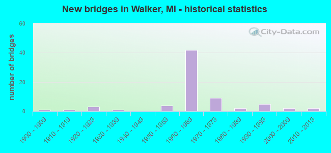
- New bridges - historical statistics
- 11900-1909
- 11910-1919
- 31920-1929
- 11930-1939
- 41950-1959
- 421960-1969
- 91970-1979
- 21980-1989
- 51990-1999
- 22000-2009
- 22010-2019
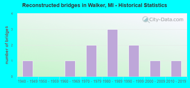
- Reconstructed bridges - Historical Statistics
- 11940-1949
- 01950-1959
- 11960-1969
- 21970-1979
- 31980-1989
- 21990-1999
- 12000-2009
- 12010-2019
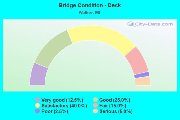
- Bridge Condition - Deck
- 12.5%Very good
- 25.0%Good
- 40.0%Satisfactory
- 15.0%Fair
- 2.5%Poor
- 5.0%Serious
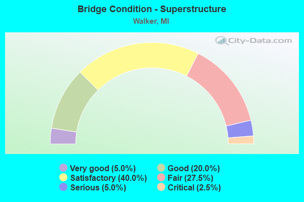
- Bridge Condition - Superstructure
- 5.0%Very good
- 20.0%Good
- 40.0%Satisfactory
- 27.5%Fair
- 5.0%Serious
- 2.5%Critical
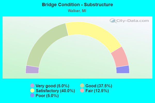
- Bridge Condition - Substructure
- 5.0%Very good
- 37.5%Good
- 40.0%Satisfactory
- 12.5%Fair
- 5.0%Poor
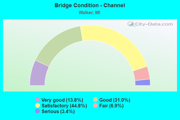
- Bridge Condition - Channel
- 13.8%Very good
- 31.0%Good
- 44.8%Satisfactory
- 6.9%Fair
- 3.4%Serious
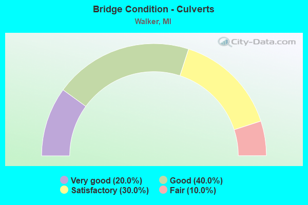
- Bridge Condition - Culverts
- 20.0%Very good
- 40.0%Good
- 30.0%Satisfactory
- 10.0%Fair
Find on map >> Show street view
Structure Number: 475, Location: 0.2 MI S OF TWINING (Lat: 44.108711, Lng: -83.696181), Route carried "on" structure: County highway , Year Built: 1925, Status: Open, Structure Length: 2.89m (9.48ft), Average Daily Traffic: 145 (year 1998), Average Future Daily Traffic: 90 (year 1977), Design Load: HS 20+Mod, Features Intersected: AUGRES RIVER, Facility Carried by Structure: COURT STREET
Minimum Vertical Clearance: 30.48m (100.00ft), Kilometerpoint: 2.694, Lanes on structure: 2, Owner: County Highway Agency, Approaching Roadway Width: 8.5m (27.9ft), Skew: 3 degrees, Material/Design: Concrete, Design/Construction: Girder and Floorbeam System, Number Of Spans In Main Unit: 1, Length of Maximum Span: 27.4m (89.9ft), Curb-To-Curb Width: 6.1m (20.0ft), Out-to-Out Width: 8.2m (26.9ft)
Condition: Deck: Serious, Superstructure: Fair, Substructure: Fair, Channel: Good, Operating Rating: 92.3 metric tons, Method Used To Determine Operating Rating: Load Factor (LF) rating reported by rating factor (RF) method using MS18 loading, Inventory Rating: 60.9 metric tons, Method Used To Determine Inventory Rating: Load Factor (LF) rating reported by rating factor (RF) method using MS18 loading, Structural Evaluation: Somewhat better than minimum adequacy, Deck Geometry: Meets minimum limits, Waterway Adequacy: Better than present minimum criteria, Approach Roadway Alignment: Better than present minimum criteria, Designated Inspection Frequency: Every 12 months, Inspection Date: August 2021, Bridge Improvement Cost: $5,000, Roadway Improvement Cost: $1,000, Total Project Cost: $6,000, Deck Structure Type: Concrete Cast-file-Place, Wearing Surface/Protective System: Wearing Surface: Monolithic Concrete
Find on map >> Show street view
Structure Number: 476, Location: 0.8 MI N OF BESSINGER RD (Lat: 44.096975, Lng: -83.685819), Route carried "on" structure: County highway , Year Built: 1985, Status: Posted for load, Structure Length: 2.92m (9.58ft), Average Daily Traffic: 200 (year 2017), Truck Traffic: 10%, Average Future Daily Traffic: 220 (year 2037), Design Load: HS 20+Mod, Features Intersected: AUGRES RIVER, Facility Carried by Structure: MACKINAW ROAD
Minimum Vertical Clearance: 30+ m (98+ ft), Kilometerpoint: 7.366, Lanes on structure: 2, Owner: County Highway Agency, Approaching Roadway Width: 8.5m (27.9ft), Skew: 3 degrees, Material/Design: Wood or Timber, Design/Construction: Slab, Number Of Spans In Main Unit: 3, Length of Maximum Span: 9.7m (31.8ft), Curb-To-Curb Width: 7.3m (24.0ft), Out-to-Out Width: 7.7m (25.3ft)
Condition: Deck: Poor, Superstructure: Serious, Substructure: Satisfactory, Channel: Serious, Operating Rating: 33.7 metric tons, Method Used To Determine Operating Rating: Allowable Stress (AS) rating reported by rating factor (RF) method using MS18 loading, Inventory Rating: 24.9 metric tons, Method Used To Determine Inventory Rating: Allowable Stress (AS) rating reported by rating factor (RF) method using MS18 loading, Structural Evaluation: High priority of corrective action, Deck Geometry: Somewhat better than minimum adequacy, Waterway Adequacy: Meets minimum limits, Approach Roadway Alignment: Equal to present minimum criteria, Bridge Posting: Required (Relationship of Operating Rating to Maximum Legal Load: > 39.9% below), Length Of Structure Improvement: 4.15m (13.62ft), Designated Inspection Frequency: Every 12 months, Inspection Date: August 2021, Bridge Improvement Cost: $393,000, Roadway Improvement Cost: $2,258,000, Total Project Cost: $2,651,000 ( Estimate for 2017), Deck Structure Type: Wood or Timber, Wearing Surface/Protective System: Wearing Surface: Bituminous, Deck Protection: Other
Find on map >> Show street view
Structure Number: 524, Location: 5 MI E OF L'ANSE (Lat: 46.755319, Lng: -88.355483), Route carried "on" structure: County highway , Year Built: 1995, Status: Open, Structure Length: 2.56m (8.40ft), Average Daily Traffic: 92 (year 2015), Truck Traffic: 3%, Average Future Daily Traffic: 150 (year 2035), Design Load: HS 25 or greater, Features Intersected: SILVER RIVER, Facility Carried by Structure: ARVON ROAD
Minimum Vertical Clearance: 30+ m (98+ ft), Kilometerpoint: 6.512, Lanes on structure: 2, Owner: County Highway Agency, Approaching Roadway Width: 9.1m (29.9ft), Skew: 4 degrees, Material/Design: Prestressed concrete, Design/Construction: Box Beam or Girders - Multiple, Number Of Spans In Main Unit: 1, Length of Maximum Span: 23.5m (77.1ft), Curb-To-Curb Width: 8.8m (28.9ft), Out-to-Out Width: 9.6m (31.5ft)
Condition: Deck: Good, Superstructure: Good, Substructure: Very good, Channel: Very good, Operating Rating: 57.9 metric tons, Method Used To Determine Operating Rating: Load Factor (LF), Inventory Rating: 34.7 metric tons, Method Used To Determine Inventory Rating: Load Factor (LF), Structural Evaluation: Better than present minimum criteria, Deck Geometry: Better than present minimum criteria, Waterway Adequacy: Better than present minimum criteria, Approach Roadway Alignment: Equal to present desirable criteria, Designated Inspection Frequency: Every 24 months, Inspection Date: September 2021, Deck Structure Type: Concrete Cast-file-Place, Wearing Surface/Protective System: Wearing Surface: Integral Concrete, Deck Protection: Epoxy Coated Reinforcing
Find on map >> Show street view
Structure Number: 4746, Location: IN WALKER (Lat: 43.018864, Lng: -85.771658), Route carried "on" structure: Interstate 96, Year Built: 1960, Status: Open, Structure Length: 1.06m (3.48ft), Average Daily Traffic: 18,169 (year 2007), Truck Traffic: 12%, Average Future Daily Traffic: 21,452 (year 2018), Design Load: HS 20+Mod, Features Intersected: SAND CREEK
Minimum Vertical Clearance: 30.48m (100.00ft), Kilometerpoint: 1.693, Lanes on structure: 2, Base Highway Network: Yes (Inventory Route: 40, Subroute: 6), Owner: State Highway Agency, Approaching Roadway Width: 12.8m (42.0ft), Material/Design: Concrete, Design/Construction: Tee Beam, Number Of Spans In Main Unit: 1, Length of Maximum Span: 10.6m (34.8ft), Curb-To-Curb Width: 12.8m (42.0ft), Out-to-Out Width: 19.3m (63.3ft)
Condition: Deck: Good, Superstructure: Good, Substructure: Satisfactory, Channel: Satisfactory, Operating Rating: 94.9 metric tons, Method Used To Determine Operating Rating: Load Factor (LF) rating reported by rating factor (RF) method using MS18 loading, Inventory Rating: 57.0 metric tons, Method Used To Determine Inventory Rating: Load Factor (LF) rating reported by rating factor (RF) method using MS18 loading, Structural Evaluation: Equal to present minimum criteria, Deck Geometry: Equal to present desirable criteria, Waterway Adequacy: Equal to present desirable criteria, Approach Roadway Alignment: Equal to present minimum criteria, Designated Inspection Frequency: Every 24 months, Inspection Date: March 2021
Find on map >> Show street view
Structure Number: 4747, Location: IN WALKER (Lat: 43.022514, Lng: -85.772794), Route carried "on" structure: Interstate 96, Year Built: 1960, Status: Open, Structure Length: 1.06m (3.48ft), Average Daily Traffic: 18,169 (year 2007), Truck Traffic: 12%, Average Future Daily Traffic: 21,452 (year 2018), Design Load: HS 20+Mod, Features Intersected: SAND CREEK
Minimum Vertical Clearance: 30.48m (100.00ft), Kilometerpoint: 1.374, Lanes on structure: 2, Base Highway Network: Yes (Inventory Route: 40, Subroute: 4), Owner: State Highway Agency, Approaching Roadway Width: 12.8m (42.0ft), Material/Design: Concrete, Design/Construction: Tee Beam, Number Of Spans In Main Unit: 1, Length of Maximum Span: 10.6m (34.8ft), Curb-To-Curb Width: 13.1m (43.0ft), Out-to-Out Width: 14.3m (46.9ft)
Condition: Deck: Satisfactory, Superstructure: Satisfactory, Substructure: Satisfactory, Channel: Satisfactory, Operating Rating: 71.6 metric tons, Method Used To Determine Operating Rating: Load Factor (LF) rating reported by rating factor (RF) method using MS18 loading, Inventory Rating: 43.1 metric tons, Method Used To Determine Inventory Rating: Load Factor (LF) rating reported by rating factor (RF) method using MS18 loading, Structural Evaluation: Equal to present minimum criteria, Deck Geometry: Superior to present desirable criteria, Waterway Adequacy: Equal to present desirable criteria, Approach Roadway Alignment: Equal to present desirable criteria, Designated Inspection Frequency: Every 24 months, Inspection Date: March 2021, Deck Structure Type: Concrete Cast-file-Place, Wearing Surface/Protective System: Wearing Surface: Latex Concrete
Find on map >> Show street view
Structure Number: 4748, Location: IN WALKER (Lat: 43.019828, Lng: -85.729861), Route carried "on" structure: Interstate 96, Year Built: 1961, Status: Open, Structure Length: 1.06m (3.48ft), Average Daily Traffic: 43,502 (year 2007), Truck Traffic: 9%, Average Future Daily Traffic: 55,537 (year 2018), Design Load: HS 20+Mod, Features Intersected: INDIAN CREEK
Minimum Vertical Clearance: 30.48m (100.00ft), Kilometerpoint: 5.161, Lanes on structure: 6, Base Highway Network: Yes (Inventory Route: 40, Subroute: 6), Owner: State Highway Agency, Approaching Roadway Width: 12.2m (40.0ft), Material/Design: Concrete, Design/Construction: Tee Beam, Number Of Spans In Main Unit: 1, Length of Maximum Span: 9.2m (30.2ft), Curb-To-Curb Width: 53.0m (173.9ft), Out-to-Out Width: 61.6m (202.1ft)
Condition: Deck: Satisfactory, Superstructure: Satisfactory, Substructure: Satisfactory, Channel: Satisfactory, Operating Rating: 65.1 metric tons, Method Used To Determine Operating Rating: Load Factor (LF) rating reported by rating factor (RF) method using MS18 loading, Inventory Rating: 39.2 metric tons, Method Used To Determine Inventory Rating: Load Factor (LF) rating reported by rating factor (RF) method using MS18 loading, Structural Evaluation: Equal to present minimum criteria, Deck Geometry: Superior to present desirable criteria, Waterway Adequacy: Equal to present desirable criteria, Approach Roadway Alignment: Equal to present desirable criteria, Designated Inspection Frequency: Every 24 months, Inspection Date: June 2020
Find on map >> Show street view
Structure Number: 4749, Location: IN WALKER (Lat: 43.018269, Lng: -85.737000), Route carried "on" structure: Interstate 96, Year Built: 1961, Status: Open, Structure Length: 5.30m (17.39ft), Average Daily Traffic: 21,751 (year 2007), Truck Traffic: 9%, Average Future Daily Traffic: 27,768 (year 2018), Design Load: HS 20+Mod, Features Intersected: COOPERSVILLE & MARNE RR
Minimum Vertical Clearance: 30+ m (98+ ft), Kilometerpoint: 4.553, Lanes on structure: 2, Base Highway Network: Yes (Inventory Route: 40, Subroute: 6), Owner: State Highway Agency, Approaching Roadway Width: 12.8m (42.0ft), Skew: 13 degrees, Material/Design: Steel, Design/Construction: Stringer/Multi-beam, Number Of Spans In Main Unit: 3, Length of Maximum Span: 18.2m (59.7ft), Curb-To-Curb Width: 13.7m (44.9ft), Out-to-Out Width: 14.3m (46.9ft)
Condition: Deck: Fair, Superstructure: Good, Substructure: Good, Operating Rating: 78.1 metric tons, Method Used To Determine Operating Rating: Load Factor (LF) rating reported by rating factor (RF) method using MS18 loading, Inventory Rating: 46.7 metric tons, Method Used To Determine Inventory Rating: Load Factor (LF) rating reported by rating factor (RF) method using MS18 loading, Structural Evaluation: Better than present minimum criteria, Deck Geometry: Superior to present desirable criteria, Approach Roadway Alignment: Better than present minimum criteria, Designated Inspection Frequency: Every 24 months, Inspection Date: June 2020, Deck Structure Type: Concrete Cast-file-Place, Wearing Surface/Protective System: Wearing Surface: Latex Concrete
Find on map >> Show street view
Structure Number: 475, Location: IN WALKER (Lat: 43.018450, Lng: -85.737397), Route carried "on" structure: Interstate 96, Year Built: 1961, Status: Open, Structure Length: 5.30m (17.39ft), Average Daily Traffic: 21,751 (year 2007), Truck Traffic: 9%, Average Future Daily Traffic: 27,768 (year 2018), Design Load: HS 20+Mod, Features Intersected: COOPERSVILLE & MARNE RR
Minimum Vertical Clearance: 30.48m (100.00ft), Kilometerpoint: 4.419, Lanes on structure: 2, Base Highway Network: Yes (Inventory Route: 40, Subroute: 4), Owner: State Highway Agency, Approaching Roadway Width: 12.8m (42.0ft), Skew: 13 degrees, Material/Design: Steel, Design/Construction: Stringer/Multi-beam, Number Of Spans In Main Unit: 3, Length of Maximum Span: 18.2m (59.7ft), Curb-To-Curb Width: 13.7m (44.9ft), Out-to-Out Width: 14.3m (46.9ft)
Condition: Deck: Fair, Superstructure: Satisfactory, Substructure: Good, Operating Rating: 78.1 metric tons, Method Used To Determine Operating Rating: Load Factor (LF) rating reported by rating factor (RF) method using MS18 loading, Inventory Rating: 46.7 metric tons, Method Used To Determine Inventory Rating: Load Factor (LF) rating reported by rating factor (RF) method using MS18 loading, Structural Evaluation: Equal to present minimum criteria, Deck Geometry: Superior to present desirable criteria, Approach Roadway Alignment: Better than present minimum criteria, Designated Inspection Frequency: Every 24 months, Inspection Date: June 2020, Deck Structure Type: Concrete Cast-file-Place, Wearing Surface/Protective System: Wearing Surface: Latex Concrete
Find on map >> Show street view
Structure Number: 4751, Location: IN WALKER (Lat: 43.012286, Lng: -85.677128), Route carried "on" structure: Ramp Interstate 96, Year Built: 1962, Status: Open, Structure Length: 12.83m (42.09ft), Average Daily Traffic: 18,528 (year 2007), Truck Traffic: 7%, Average Future Daily Traffic: 31,438 (year 2018), Design Load: HS 20+Mod, Features Intersected: W RIVER DRV, CSX & PC RR
Minimum Vertical Clearance: 30.48m (100.00ft), Kilometerpoint: 0.322, Lanes on structure: 2, Lanes under structure: 2, Owner: State Highway Agency, Approaching Roadway Width: 10.3m (33.8ft), Skew: 3 degrees, Material/Design: Steel, Design/Construction: Stringer/Multi-beam, Number Of Spans In Main Unit: 6, Length of Maximum Span: 23.4m (76.8ft), Curb-To-Curb Width: 9.7m (31.8ft), Out-to-Out Width: 10.9m (35.8ft)
Condition: Deck: Satisfactory, Superstructure: Satisfactory, Substructure: Satisfactory, Operating Rating: 62.5 metric tons, Method Used To Determine Operating Rating: Load Factor (LF) rating reported by rating factor (RF) method using MS18 loading, Inventory Rating: 37.6 metric tons, Method Used To Determine Inventory Rating: Load Factor (LF) rating reported by rating factor (RF) method using MS18 loading, Structural Evaluation: Equal to present minimum criteria, Deck Geometry: Somewhat better than minimum adequacy, Underclear: Equal to present minimum criteria, Approach Roadway Alignment: Equal to present minimum criteria, Designated Inspection Frequency: Every 24 months, Inspection Date: June 2020, Deck Structure Type: Concrete Cast-file-Place, Wearing Surface/Protective System: Wearing Surface: Integral Concrete
Find on map >> Show street view
Structure Number: 4752, Location: 0.9 MI E OF M-37 INTRCHG (Lat: 43.013872, Lng: -85.675897), Route carried "on" structure: Ramp Interstate 296, Year Built: 1962, Year Reconstructed: 1988, Status: Open, Structure Length: 15.03m (49.31ft), Average Daily Traffic: 18,528 (year 2007), Truck Traffic: 10%, Average Future Daily Traffic: 136,000 (year 2026), Design Load: HS 20+Mod, Features Intersected: US-131 SB, CR & CSX RR
Minimum Vertical Clearance: 30.48m (100.00ft), Kilometerpoint: 0.304, Lanes on structure: 2, Lanes under structure: 6, Owner: State Highway Agency, Approaching Roadway Width: 10.9m (35.8ft), Skew: 2 degrees, Material/Design: Steel, Design/Construction: Stringer/Multi-beam, Number Of Spans In Main Unit: 7, Length of Maximum Span: 25.3m (83.0ft), Curb-To-Curb Width: 9.7m (31.8ft), Out-to-Out Width: 10.9m (35.8ft)
Condition: Deck: Satisfactory, Superstructure: Fair, Substructure: Satisfactory, Operating Rating: 77.8 metric tons, Method Used To Determine Operating Rating: Load Factor (LF), Inventory Rating: 46.7 metric tons, Method Used To Determine Inventory Rating: Load Factor (LF), Structural Evaluation: Somewhat better than minimum adequacy, Deck Geometry: Somewhat better than minimum adequacy, Underclear: Equal to present minimum criteria, Approach Roadway Alignment: Better than present minimum criteria, Designated Inspection Frequency: Every 24 months, Inspection Date: June 2020, Deck Structure Type: Concrete Cast-file-Place, Wearing Surface/Protective System: Wearing Surface: Latex Concrete
Find on map >> Show street view
Structure Number: 4753, Location: IN WALKER (Lat: 43.019253, Lng: -85.673272), Route carried "on" structure: Interstate 96, Year Built: 1962, Status: Open, Structure Length: 16.59m (54.43ft), Average Daily Traffic: 30,650 (year 2015), Truck Traffic: 6%, Average Future Daily Traffic: 36,400 (year 2038), Design Load: HS 20+Mod, Features Intersected: CSX, CR RR & W RIVER DRV
Minimum Vertical Clearance: 30.48m (100.00ft), Kilometerpoint: 9.990, Lanes on structure: 2, Lanes under structure: 2, Base Highway Network: Yes (Inventory Route: 40, Subroute: 6), Owner: State Highway Agency, Approaching Roadway Width: 9.1m (29.9ft), Skew: 5 degrees, Material/Design: Steel, Design/Construction: Stringer/Multi-beam, Number Of Spans In Main Unit: 6, Length of Maximum Span: 31.7m (104.0ft), Curb-To-Curb Width: 10.1m (33.1ft), Out-to-Out Width: 10.9m (35.8ft)
Condition: Deck: Good, Superstructure: Satisfactory, Substructure: Good, Operating Rating: 72.9 metric tons, Method Used To Determine Operating Rating: Load Factor (LF) rating reported by rating factor (RF) method using MS18 loading, Inventory Rating: 43.7 metric tons, Method Used To Determine Inventory Rating: Load Factor (LF) rating reported by rating factor (RF) method using MS18 loading, Structural Evaluation: Equal to present minimum criteria, Deck Geometry: Meets minimum limits, Underclear: Meets minimum limits, Approach Roadway Alignment: Equal to present desirable criteria, Designated Inspection Frequency: Every 24 months, Inspection Date: June 2020, Deck Structure Type: Concrete Cast-file-Place, Wearing Surface/Protective System: Wearing Surface: Latex Concrete
Find on map >> Show street view
Structure Number: 4754, Location: IN WALKER (Lat: 43.019667, Lng: -85.673047), Route carried "on" structure: Interstate 96, Year Built: 1962, Status: Open, Structure Length: 16.59m (54.43ft), Average Daily Traffic: 30,650 (year 2015), Truck Traffic: 6%, Average Future Daily Traffic: 36,400 (year 2038), Design Load: HS 20+Mod, Features Intersected: CSX, CR RR & W RIVER DRV
Minimum Vertical Clearance: 30.48m (100.00ft), Kilometerpoint: 9.845, Lanes on structure: 2, Lanes under structure: 2, Base Highway Network: Yes (Inventory Route: 40, Subroute: 4), Owner: State Highway Agency, Approaching Roadway Width: 9.1m (29.9ft), Skew: 5 degrees, Material/Design: Steel, Design/Construction: Stringer/Multi-beam, Number Of Spans In Main Unit: 6, Length of Maximum Span: 31.7m (104.0ft), Curb-To-Curb Width: 10.1m (33.1ft), Out-to-Out Width: 10.9m (35.8ft)
Condition: Deck: Good, Superstructure: Satisfactory, Substructure: Good, Operating Rating: 69.7 metric tons, Method Used To Determine Operating Rating: Load Factor (LF) rating reported by rating factor (RF) method using MS18 loading, Inventory Rating: 41.8 metric tons, Method Used To Determine Inventory Rating: Load Factor (LF) rating reported by rating factor (RF) method using MS18 loading, Structural Evaluation: Equal to present minimum criteria, Deck Geometry: Meets minimum limits, Underclear: Meets minimum limits, Approach Roadway Alignment: Equal to present desirable criteria, Designated Inspection Frequency: Every 24 months, Inspection Date: June 2020, Deck Structure Type: Concrete Cast-file-Place, Wearing Surface/Protective System: Wearing Surface: Latex Concrete
Find on map >> Show street view
Structure Number: 4755, Location: IN WALKER (Lat: 43.017800, Lng: -85.763253), Route carried "on" structure: City street 2001, Year Built: 1961, Status: Open, Structure Length: 11.28m (37.01ft), Average Daily Traffic: 11,830 (year 1996), Truck Traffic: 3%, Average Future Daily Traffic: 13,605 (year 2016), Design Load: HS 20, Features Intersected: I-96, Facility Carried by Structure: FRUIT RIDGE RD
Minimum Vertical Clearance: 30.48m (100.00ft), Kilometerpoint: 0.214, Lanes on structure: 2, Lanes under structure: 5, Base Highway Network: Yes (Inventory Route: 40, Subroute: 1), Owner: State Highway Agency, Approaching Roadway Width: 10.9m (35.8ft), Material/Design: Steel, Design/Construction: Stringer/Multi-beam, Number Of Spans In Main Unit: 6, Length of Maximum Span: 20.1m (65.9ft), Curb-To-Curb Width: 9.2m (30.2ft), Out-to-Out Width: 10.0m (32.8ft)
Condition: Deck: Fair, Superstructure: Fair, Substructure: Poor, Operating Rating: 78.1 metric tons, Method Used To Determine Operating Rating: Load Factor (LF) rating reported by rating factor (RF) method using MS18 loading, Inventory Rating: 47.0 metric tons, Method Used To Determine Inventory Rating: Load Factor (LF) rating reported by rating factor (RF) method using MS18 loading, Structural Evaluation: Meets minimum limits, Deck Geometry: Meets minimum limits, Underclear: Somewhat better than minimum adequacy, Approach Roadway Alignment: Better than present minimum criteria, Designated Inspection Frequency: Every 12 months, Inspection Date: March 2022, Bridge Improvement Cost: $187,000, Deck Structure Type: Concrete Cast-file-Place, Wearing Surface/Protective System: Wearing Surface: Latex Concrete
Find on map >> Show street view
Structure Number: 4756, Location: IN WALKER (Lat: 43.020892, Lng: -85.725706), Route carried "on" structure: City street 2001, Year Built: 2006, Status: Open, Structure Length: 5.61m (18.41ft), Average Daily Traffic: 18,890 (year 2001), Average Future Daily Traffic: 21,724 (year 2021), Design Load: HS 25 or greater, Features Intersected: I-96, Facility Carried by Structure: WALKER AVE
Minimum Vertical Clearance: 30.48m (100.00ft), Kilometerpoint: 6.029, Lanes on structure: 2, Lanes under structure: 4, Owner: State Highway Agency, Approaching Roadway Width: 24.4m (80.1ft), Material/Design: Prestressed concrete, Design/Construction: Box Beam or Girders - Single/Spread, Number Of Spans In Main Unit: 2, Length of Maximum Span: 28.1m (92.2ft), Curb-To-Curb Width: 23.7m (77.8ft), Out-to-Out Width: 26.9m (88.3ft)
Condition: Deck: Satisfactory, Superstructure: Good, Substructure: Good, Operating Rating: 86.5 metric tons, Method Used To Determine Operating Rating: Load Factor (LF) rating reported by rating factor (RF) method using MS18 loading, Inventory Rating: 34.7 metric tons, Method Used To Determine Inventory Rating: Load Factor (LF) rating reported by rating factor (RF) method using MS18 loading, Structural Evaluation: Better than present minimum criteria, Deck Geometry: Superior to present desirable criteria, Underclear: Equal to present minimum criteria, Approach Roadway Alignment: Better than present minimum criteria, Designated Inspection Frequency: Every 24 months, Inspection Date: October 2020, Deck Structure Type: Concrete Cast-file-Place, Wearing Surface/Protective System: Wearing Surface: Monolithic Concrete, Deck Protection: Epoxy Coated Reinforcing
Find on map >> Show street view
Structure Number: 4757, Location: IN WALKER (Lat: 43.020117, Lng: -85.708622), Route carried "on" structure: Interstate 96, Year Built: 1961, Status: Open, Structure Length: 3.44m (11.29ft), Average Daily Traffic: 27,527 (year 2007), Truck Traffic: 7%, Average Future Daily Traffic: 33,602 (year 2018), Design Load: HS 20+Mod, Features Intersected: BRISTOL RD
Minimum Vertical Clearance: 30.48m (100.00ft), Kilometerpoint: 6.937, Lanes on structure: 2, Lanes under structure: 2, Base Highway Network: Yes (Inventory Route: 40, Subroute: 6), Owner: State Highway Agency, Approaching Roadway Width: 12.8m (42.0ft), Skew: 11 degrees, Material/Design: Steel, Design/Construction: Stringer/Multi-beam, Number Of Spans In Main Unit: 3, Length of Maximum Span: 12.8m (42.0ft), Curb-To-Curb Width: 13.2m (43.3ft), Out-to-Out Width: 14.3m (46.9ft)
Condition: Deck: Satisfactory, Superstructure: Fair, Substructure: Satisfactory, Operating Rating: 58.0 metric tons, Method Used To Determine Operating Rating: Load Factor (LF) rating reported by rating factor (RF) method using MS18 loading, Inventory Rating: 34.7 metric tons, Method Used To Determine Inventory Rating: Load Factor (LF) rating reported by rating factor (RF) method using MS18 loading, Structural Evaluation: Somewhat better than minimum adequacy, Deck Geometry: Superior to present desirable criteria, Underclear: Somewhat better than minimum adequacy, Approach Roadway Alignment: Equal to present minimum criteria, Designated Inspection Frequency: Every 24 months, Inspection Date: March 2021, Bridge Improvement Cost: $64,000, Deck Structure Type: Concrete Cast-file-Place, Wearing Surface/Protective System: Wearing Surface: Latex Concrete
Find on map >> Show street view
Structure Number: 4759, Location: IN WALKER (Lat: 43.015836, Lng: -85.688872), Route carried "on" structure: State highway 37, Year Built: 1961, Year Reconstructed: 1988, Status: Open, Structure Length: 4.39m (14.40ft), Average Daily Traffic: 52,285 (year 2007), Truck Traffic: 1%, Average Future Daily Traffic: 68,012 (year 2018), Design Load: HS 20+Mod, Features Intersected: I-96 EB
Minimum Vertical Clearance: 30.48m (100.00ft), Kilometerpoint: 4.645, Lanes on structure: 7, Lanes under structure: 3, Base Highway Network: Yes (Inventory Route: 42, Subroute: 10), Owner: State Highway Agency, Approaching Roadway Width: 14.0m (45.9ft), Skew: 21 degrees, Material/Design: Steel, Design/Construction: Stringer/Multi-beam, Number Of Spans In Main Unit: 3, Length of Maximum Span: 20.7m (67.9ft), Curb-To-Curb Width: 29.8m (97.8ft), Out-to-Out Width: 30.8m (101.0ft)
Condition: Deck: Good, Superstructure: Good, Substructure: Satisfactory, Operating Rating: 63.1 metric tons, Method Used To Determine Operating Rating: Load Factor (LF), Inventory Rating: 37.8 metric tons, Method Used To Determine Inventory Rating: Load Factor (LF), Structural Evaluation: Equal to present minimum criteria, Deck Geometry: Equal to present minimum criteria, Underclear: High priority of corrective action, Approach Roadway Alignment: Better than present minimum criteria, Designated Inspection Frequency: Every 24 months, Inspection Date: October 2020, Deck Structure Type: Concrete Cast-file-Place, Wearing Surface/Protective System: Wearing Surface: Monolithic Concrete, Deck Protection: Epoxy Coated Reinforcing
Find on map >> Show street view
Structure Number: 476, Location: IN WALKER (Lat: 43.017447, Lng: -85.688936), Route carried "on" structure: State highway 37, Year Built: 1961, Year Reconstructed: 1988, Status: Open, Structure Length: 4.36m (14.30ft), Average Daily Traffic: 52,285 (year 2007), Truck Traffic: 1%, Average Future Daily Traffic: 68,012 (year 2018), Design Load: HS 20+Mod, Features Intersected: I-96 WB
Minimum Vertical Clearance: 30.48m (100.00ft), Kilometerpoint: 4.466, Lanes on structure: 5, Lanes under structure: 3, Base Highway Network: Yes (Inventory Route: 42, Subroute: 10), Owner: State Highway Agency, Approaching Roadway Width: 10.9m (35.8ft), Skew: 21 degrees, Material/Design: Steel, Design/Construction: Stringer/Multi-beam, Number Of Spans In Main Unit: 3, Length of Maximum Span: 20.7m (67.9ft), Curb-To-Curb Width: 29.8m (97.8ft), Out-to-Out Width: 30.8m (101.0ft)
Condition: Deck: Good, Superstructure: Fair, Substructure: Fair, Operating Rating: 60.9 metric tons, Method Used To Determine Operating Rating: Load Factor (LF) rating reported by rating factor (RF) method using MS18 loading, Inventory Rating: 36.6 metric tons, Method Used To Determine Inventory Rating: Load Factor (LF) rating reported by rating factor (RF) method using MS18 loading, Structural Evaluation: Somewhat better than minimum adequacy, Deck Geometry: Superior to present desirable criteria, Underclear: High priority of corrective action, Approach Roadway Alignment: Equal to present desirable criteria, Designated Inspection Frequency: Every 24 months, Inspection Date: October 2020, Deck Structure Type: Concrete Cast-file-Place, Wearing Surface/Protective System: Wearing Surface: Latex Concrete, Deck Protection: Epoxy Coated Reinforcing
Find on map >> Show street view
Structure Number: 4761, Location: IN WALKER (Lat: 43.016200, Lng: -85.680794), Route carried "on" structure: Ramp Interstate 296, Year Built: 1962, Status: Open, Structure Length: 7.68m (25.20ft), Average Daily Traffic: 18,528 (year 2007), Truck Traffic: 7%, Average Future Daily Traffic: 31,438 (year 2018), Design Load: HS 20+Mod, Features Intersected: I-96 EB
Minimum Vertical Clearance: 30.48m (100.00ft), Kilometerpoint: 0.795, Lanes on structure: 3, Lanes under structure: 2, Owner: State Highway Agency, Approaching Roadway Width: 12.8m (42.0ft), Skew: 5 degrees, Material/Design: Steel, Design/Construction: Stringer/Multi-beam, Number Of Spans In Main Unit: 3, Length of Maximum Span: 34.7m (113.8ft), Curb-To-Curb Width: 14.3m (46.9ft), Out-to-Out Width: 15.2m (49.9ft)
Condition: Deck: Satisfactory, Superstructure: Satisfactory, Substructure: Satisfactory, Operating Rating: 59.9 metric tons, Method Used To Determine Operating Rating: Load Factor (LF) rating reported by rating factor (RF) method using MS18 loading, Inventory Rating: 36.0 metric tons, Method Used To Determine Inventory Rating: Load Factor (LF) rating reported by rating factor (RF) method using MS18 loading, Structural Evaluation: Equal to present minimum criteria, Deck Geometry: Better than present minimum criteria, Underclear: Equal to present minimum criteria, Approach Roadway Alignment: Equal to present desirable criteria, Designated Inspection Frequency: Every 24 months, Inspection Date: August 2020, Deck Structure Type: Concrete Cast-file-Place, Wearing Surface/Protective System: Wearing Surface: Latex Concrete
Find on map >> Show street view
Structure Number: 4762, Location: IN WALKER (Lat: 43.020992, Lng: -85.668022), Route carried "on" structure: Interstate 96, Year Built: 1962, Status: Open, Structure Length: 9.60m (31.50ft), Average Daily Traffic: 23,263 (year 2015), Truck Traffic: 8%, Average Future Daily Traffic: 27,625 (year 2038), Design Load: HS 20+Mod, Features Intersected: US-131
Minimum Vertical Clearance: 30.48m (100.00ft), Kilometerpoint: 10.461, Lanes on structure: 3, Lanes under structure: 6, Base Highway Network: Yes (Inventory Route: 40, Subroute: 6), Owner: State Highway Agency, Approaching Roadway Width: 15.2m (49.9ft), Skew: 3 degrees, Material/Design: Steel, Design/Construction: Stringer/Multi-beam, Number Of Spans In Main Unit: 4, Length of Maximum Span: 32.6m (107.0ft), Curb-To-Curb Width: 13.7m (44.9ft), Out-to-Out Width: 14.7m (48.2ft)
Condition: Deck: Satisfactory, Superstructure: Satisfactory, Substructure: Satisfactory, Operating Rating: 72.6 metric tons, Method Used To Determine Operating Rating: Load Factor (LF) rating reported by rating factor (RF) method using MS18 loading, Inventory Rating: 43.4 metric tons, Method Used To Determine Inventory Rating: Load Factor (LF) rating reported by rating factor (RF) method using MS18 loading, Structural Evaluation: Equal to present minimum criteria, Deck Geometry: Meets minimum limits, Underclear: High priority of corrective action, Approach Roadway Alignment: Equal to present desirable criteria, Designated Inspection Frequency: Every 24 months, Inspection Date: June 2020, Bridge Improvement Cost: $334,000, Deck Structure Type: Concrete Cast-file-Place, Wearing Surface/Protective System: Wearing Surface: Epoxy Overlay
Find on map >> Show street view
Structure Number: 4763, Location: IN WALKER (Lat: 43.021308, Lng: -85.667778), Route carried "on" structure: Interstate 96, Year Built: 1962, Status: Open, Structure Length: 9.39m (30.81ft), Average Daily Traffic: 23,263 (year 2015), Truck Traffic: 8%, Average Future Daily Traffic: 27,625 (year 2038), Design Load: HS 20+Mod, Features Intersected: US-131
Minimum Vertical Clearance: 30.48m (100.00ft), Kilometerpoint: 10.315, Lanes on structure: 3, Lanes under structure: 6, Base Highway Network: Yes (Inventory Route: 40, Subroute: 4), Owner: State Highway Agency, Approaching Roadway Width: 15.2m (49.9ft), Skew: 3 degrees, Material/Design: Steel, Design/Construction: Stringer/Multi-beam, Number Of Spans In Main Unit: 4, Length of Maximum Span: 31.7m (104.0ft), Curb-To-Curb Width: 13.7m (44.9ft), Out-to-Out Width: 14.6m (47.9ft)
Condition: Deck: Good, Superstructure: Satisfactory, Substructure: Satisfactory, Operating Rating: 64.8 metric tons, Method Used To Determine Operating Rating: Load Factor (LF) rating reported by rating factor (RF) method using MS18 loading, Inventory Rating: 38.6 metric tons, Method Used To Determine Inventory Rating: Load Factor (LF) rating reported by rating factor (RF) method using MS18 loading, Structural Evaluation: Equal to present minimum criteria, Deck Geometry: Meets minimum limits, Underclear: Meets minimum limits, Approach Roadway Alignment: Equal to present desirable criteria, Designated Inspection Frequency: Every 24 months, Inspection Date: June 2020, Bridge Improvement Cost: $328,000, Deck Structure Type: Concrete Cast-file-Place, Wearing Surface/Protective System: Wearing Surface: Latex Concrete
Find on map >> Show street view
Structure Number: 4983, Location: 100' S OF NORTH PARK ST (Lat: 43.024503, Lng: -85.666144), Route carried "on" structure: US 131, Year Built: 1961, Year Reconstructed: 1966, Status: Open, Structure Length: 0.76m (2.49ft), Average Daily Traffic: 51,742 (year 2007), Truck Traffic: 7%, Average Future Daily Traffic: 75,750 (year 2018), Design Load: HS 20, Features Intersected: DRAIN
Minimum Vertical Clearance: 30.48m (100.00ft), Kilometerpoint: 29.384, Lanes on structure: 6, Base Highway Network: Yes (Inventory Route: 41, Subroute: 3), Owner: State Highway Agency, Approaching Roadway Width: 48.8m (160.1ft), Skew: 20 degrees, Material/Design: Concrete, Design/Construction: Culvert, Number Of Spans In Main Unit: 2, Length of Maximum Span: 3.9m (12.8ft)
Condition: Channel: Satisfactory, Culverts: Good, Operating Rating: 97.2 metric tons, Method Used To Determine Operating Rating: Load Factor (LF) rating reported by rating factor (RF) method using MS18 loading, Inventory Rating: 97.2 metric tons, Method Used To Determine Inventory Rating: Load Factor (LF) rating reported by rating factor (RF) method using MS18 loading, Structural Evaluation: Better than present minimum criteria, Waterway Adequacy: Equal to present desirable criteria, Approach Roadway Alignment: Equal to present desirable criteria, Designated Inspection Frequency: Every 24 months, Inspection Date: October 2021
Find on map >> Show street view
Structure Number: 4987, Location: 0.3 MI N OF I-96 (Lat: 43.025150, Lng: -85.666325), Route carried "on" structure: US 131, Year Built: 1969, Year Reconstructed: 1998, Status: Open, Structure Length: 4.11m (13.48ft), Average Daily Traffic: 25,871 (year 2007), Truck Traffic: 7%, Average Future Daily Traffic: 37,875 (year 2018), Design Load: HS 20, Features Intersected: NORTH PARK ST
Minimum Vertical Clearance: 30.48m (100.00ft), Kilometerpoint: 29.532, Lanes on structure: 3, Lanes under structure: 4, Base Highway Network: Yes (Inventory Route: 41, Subroute: 7), Owner: State Highway Agency, Approaching Roadway Width: 14.0m (45.9ft), Skew: 2 degrees, Material/Design: Steel, Design/Construction: Stringer/Multi-beam, Number Of Spans In Main Unit: 3, Length of Maximum Span: 19.2m (63.0ft), Curb-To-Curb Width: 19.5m (64.0ft), Out-to-Out Width: 20.5m (67.3ft)
Condition: Deck: Good, Superstructure: Fair, Substructure: Good, Operating Rating: 63.2 metric tons, Method Used To Determine Operating Rating: Load Factor (LF) rating reported by rating factor (RF) method using MS18 loading, Inventory Rating: 37.9 metric tons, Method Used To Determine Inventory Rating: Load Factor (LF) rating reported by rating factor (RF) method using MS18 loading, Structural Evaluation: Somewhat better than minimum adequacy, Deck Geometry: Superior to present desirable criteria, Underclear: Equal to present minimum criteria, Approach Roadway Alignment: Equal to present desirable criteria, Designated Inspection Frequency: Every 24 months, Inspection Date: June 2021, Deck Structure Type: Concrete Cast-file-Place, Wearing Surface/Protective System: Wearing Surface: Latex Concrete
Find on map >> Show street view
Structure Number: 4988, Location: 0.3 MI N OF I-96 (Lat: 43.024969, Lng: -85.665981), Route carried "on" structure: US 131, Year Built: 1969, Year Reconstructed: 1998, Status: Open, Structure Length: 4.11m (13.48ft), Average Daily Traffic: 25,871 (year 2007), Truck Traffic: 7%, Average Future Daily Traffic: 37,875 (year 2018), Design Load: HS 20, Features Intersected: NORTH PARK ST
Minimum Vertical Clearance: 30.48m (100.00ft), Kilometerpoint: 29.438, Lanes on structure: 3, Lanes under structure: 4, Base Highway Network: Yes (Inventory Route: 41, Subroute: 3), Owner: State Highway Agency, Approaching Roadway Width: 14.0m (45.9ft), Skew: 2 degrees, Material/Design: Steel, Design/Construction: Stringer/Multi-beam, Number Of Spans In Main Unit: 3, Length of Maximum Span: 19.2m (63.0ft), Curb-To-Curb Width: 19.5m (64.0ft), Out-to-Out Width: 20.5m (67.3ft)
Condition: Deck: Satisfactory, Superstructure: Fair, Substructure: Good, Operating Rating: 63.2 metric tons, Method Used To Determine Operating Rating: Load Factor (LF) rating reported by rating factor (RF) method using MS18 loading, Inventory Rating: 37.9 metric tons, Method Used To Determine Inventory Rating: Load Factor (LF) rating reported by rating factor (RF) method using MS18 loading, Structural Evaluation: Somewhat better than minimum adequacy, Deck Geometry: Superior to present desirable criteria, Underclear: Equal to present minimum criteria, Approach Roadway Alignment: Better than present minimum criteria, Designated Inspection Frequency: Every 24 months, Inspection Date: June 2021, Deck Structure Type: Concrete Cast-file-Place, Wearing Surface/Protective System: Wearing Surface: Monolithic Concrete, Deck Protection: Epoxy Coated Reinforcing
Find on map >> Show street view
Structure Number: 5023, Location: 0.25 MI W OF FRUIT RIDGE (Lat: 43.030600, Lng: -85.768447), Route carried "on" structure: County highway 2001, Year Built: 1976, Status: Open, Structure Length: 1.09m (3.58ft), Average Daily Traffic: 2,547 (year 2004), Average Future Daily Traffic: 4,330 (year 2024), Design Load: HS 20+Mod, Features Intersected: NO NAME CREEK, Facility Carried by Structure: 4 MILE RD
Minimum Vertical Clearance: 30.48m (100.00ft), Kilometerpoint: 2.654, Lanes on structure: 2, Owner: County Highway Agency, Approaching Roadway Width: 7.3m (24.0ft), Skew: 1 degrees, Material/Design: Steel, Design/Construction: Culvert, Number Of Spans In Main Unit: 3, Length of Maximum Span: 3.6m (11.8ft)
Condition: Channel: Satisfactory, Culverts: Good, Operating Rating: 57.3 metric tons, Method Used To Determine Operating Rating: Load Factor (LF) rating reported by rating factor (RF) method using MS18 loading, Inventory Rating: 51.8 metric tons, Method Used To Determine Inventory Rating: Load Factor (LF) rating reported by rating factor (RF) method using MS18 loading, Structural Evaluation: Better than present minimum criteria, Waterway Adequacy: Better than present minimum criteria, Approach Roadway Alignment: Equal to present desirable criteria, Designated Inspection Frequency: Every 24 months, Inspection Date: October 2021
Find on map >> Show street view
Structure Number: 5024, Location: 0.04 MI W OF WALKER AVE (Lat: 43.029889, Lng: -85.731353), Route carried "on" structure: County highway 2001, Year Built: 1918, Year Reconstructed: 1954, Status: Open, Structure Length: 0.94m (3.08ft), Average Daily Traffic: 8,072 (year 2004), Average Future Daily Traffic: 13,720 (year 2024), Design Load: HS 20+Mod, Features Intersected: INDIAN MILL CREEK, Facility Carried by Structure: 4 MILE RD
Minimum Vertical Clearance: 30.48m (100.00ft), Kilometerpoint: 5.676, Lanes on structure: 2, Owner: County Highway Agency, Approaching Roadway Width: 8.5m (27.9ft), Material/Design: Steel, Design/Construction: Stringer/Multi-beam, Number Of Spans In Main Unit: 1, Length of Maximum Span: 8.2m (26.9ft), Curb-To-Curb Width: 16.8m (55.1ft), Out-to-Out Width: 17.3m (56.8ft)
Condition: Deck: Very good, Superstructure: Satisfactory, Substructure: Satisfactory, Channel: Very good, Operating Rating: 37.7 metric tons, Method Used To Determine Operating Rating: Load Factor (LF), Inventory Rating: 22.6 metric tons, Method Used To Determine Inventory Rating: Load Factor (LF), Structural Evaluation: Somewhat better than minimum adequacy, Deck Geometry: Superior to present desirable criteria, Waterway Adequacy: Equal to present minimum criteria, Approach Roadway Alignment: Equal to present desirable criteria, Designated Inspection Frequency: Every 24 months, Inspection Date: October 2021, Deck Structure Type: Concrete Cast-file-Place, Wearing Surface/Protective System: Wearing Surface: Bituminous
Find on map >> Show street view
Structure Number: 5084, Location: 0.15 MI E OF KENOWA AVE (Lat: 43.059808, Lng: -85.785606), Route carried "on" structure: County highway , Year Built: 1988, Status: Open, Structure Length: 0.61m (2.00ft), Average Daily Traffic: 1,711 (year 2004), Average Future Daily Traffic: 2,910 (year 2024), Design Load: HS 20+Mod, Features Intersected: LAUBACH COUNTY DRAIN, Facility Carried by Structure: 6 MILE ROAD
Minimum Vertical Clearance: 30.48m (100.00ft), Kilometerpoint: 0.209, Lanes on structure: 2, Owner: County Highway Agency, Approaching Roadway Width: 12.2m (40.0ft), Material/Design: Concrete, Design/Construction: Culvert, Number Of Spans In Main Unit: 2, Length of Maximum Span: 3.0m (9.8ft)
Condition: Channel: Good, Culverts: Very good, Operating Rating: 50.5 metric tons, Method Used To Determine Operating Rating: Load Factor (LF) rating reported by rating factor (RF) method using MS18 loading, Inventory Rating: 44.1 metric tons, Method Used To Determine Inventory Rating: Load Factor (LF) rating reported by rating factor (RF) method using MS18 loading, Structural Evaluation: Equal to present desirable criteria, Waterway Adequacy: Equal to present desirable criteria, Approach Roadway Alignment: Equal to present desirable criteria, Designated Inspection Frequency: Every 24 months, Inspection Date: October 2021, Deck Structure Type: Concrete Cast-file-Place, Wearing Surface/Protective System: Wearing Surface: Bituminous
Find on map >> Show street view
Structure Number: 5112, Location: 0.30 MI W OF FRUIT RIDGE (Lat: 43.045197, Lng: -85.774081), Route carried "on" structure: County highway , Year Built: 1977, Status: Open, Structure Length: 1.15m (3.77ft), Average Daily Traffic: 428 (year 2004), Average Future Daily Traffic: 730 (year 2024), Design Load: HS 20+Mod, Features Intersected: LAUBACH COUNTY DRAIN, Facility Carried by Structure: 5 MILE RD
Minimum Vertical Clearance: 30.48m (100.00ft), Kilometerpoint: 1.139, Lanes on structure: 2, Owner: County Highway Agency, Approaching Roadway Width: 6.7m (22.0ft), Material/Design: Steel, Design/Construction: Culvert, Number Of Spans In Main Unit: 3, Length of Maximum Span: 3.9m (12.8ft)
Condition: Channel: Good, Culverts: Satisfactory, Operating Rating: 41.8 metric tons, Method Used To Determine Operating Rating: Load Factor (LF) rating reported by rating factor (RF) method using MS18 loading, Inventory Rating: 34.7 metric tons, Method Used To Determine Inventory Rating: Load Factor (LF) rating reported by rating factor (RF) method using MS18 loading, Structural Evaluation: Equal to present minimum criteria, Waterway Adequacy: Equal to present desirable criteria, Approach Roadway Alignment: Equal to present desirable criteria, Designated Inspection Frequency: Every 24 months, Inspection Date: October 2021
Find on map >> Show street view
Structure Number: 5235, Location: 0.50 MI W OF WALKER AVE (Lat: 43.015158, Lng: -85.734039), Route carried "on" structure: City street , Year Built: 2010, Status: Open, Structure Length: 1.39m (4.56ft), Average Daily Traffic: 12,274 (year 2014), Truck Traffic: 12%, Average Future Daily Traffic: 19,370 (year 2028), Design Load: HS 20, Features Intersected: INDIAN MILL CREEK, Facility Carried by Structure: 3 MILE RD
Minimum Vertical Clearance: 30.48m (100.00ft), Kilometerpoint: 4.329, Lanes on structure: 2, Owner: City or Municipal Highway Agency, Approaching Roadway Width: 12.5m (41.0ft), Skew: 2 degrees, Material/Design: Concrete, Design/Construction: Culvert, Number Of Spans In Main Unit: 1, Length of Maximum Span: 12.8m (42.0ft), Curb or Sidewalk Widths: Left: 2.4m (7.9ft), Right: 2.4m (7.9ft), Curb-To-Curb Width: 13.1m (43.0ft), Out-to-Out Width: 24.4m (80.1ft)
Condition: Channel: Very good, Culverts: Good, Operating Rating: 52.5 metric tons, Method Used To Determine Operating Rating: Load and Resistance Factor Rating (LRFR) rating reported by rating factor(RF) method using HL-93 loadings, Inventory Rating: 40.5 metric tons, Method Used To Determine Inventory Rating: Load and Resistance Factor Rating (LRFR) rating reported by rating factor(RF) method using HL-93 loadings, Structural Evaluation: Better than present minimum criteria, Deck Geometry: Somewhat better than minimum adequacy, Waterway Adequacy: Equal to present desirable criteria, Approach Roadway Alignment: Equal to present desirable criteria, Designated Inspection Frequency: Every 24 months, Inspection Date: October 2020
Find on map >> Show street view
Structure Number: 5238, Location: 0.4 MI N OF RICHMOND AVE (Lat: 42.998933, Lng: -85.708008), Route carried "on" structure: City street , Year Built: 1930, Year Reconstructed: 1983, Status: Posted for load, Structure Length: 1.22m (4.00ft), Average Daily Traffic: 6,667 (year 2020), Truck Traffic: 7%, Average Future Daily Traffic: 7,500 (year 2030), Design Load: HS 20+Mod, Features Intersected: INDIAN MILL CREEK, Facility Carried by Structure: BRISTOL AVE
Minimum Vertical Clearance: 30.48m (100.00ft), Kilometerpoint: 1.415, Lanes on structure: 2, Owner: City or Municipal Highway Agency, Approaching Roadway Width: 8.2m (26.9ft), Material/Design: Steel, Design/Construction: Stringer/Multi-beam, Number Of Spans In Main Unit: 1, Length of Maximum Span: 10.9m (35.8ft), Curb-To-Curb Width: 6.4m (21.0ft), Out-to-Out Width: 7.5m (24.6ft)
Condition: Deck: Satisfactory, Superstructure: Fair, Substructure: Satisfactory, Channel: Fair, Operating Rating: 25.6 metric tons, Method Used To Determine Operating Rating: Load and Resistance Factor Rating (LRFR) rating reported by rating factor(RF) method using HL-93 loadings, Inventory Rating: 19.8 metric tons, Method Used To Determine Inventory Rating: Load and Resistance Factor Rating (LRFR) rating reported by rating factor(RF) method using HL-93 loadings, Structural Evaluation: Somewhat better than minimum adequacy, Deck Geometry: High priority of replacement, Waterway Adequacy: Somewhat better than minimum adequacy, Approach Roadway Alignment: Equal to present desirable criteria, Bridge Posting: Required (Relationship of Operating Rating to Maximum Legal Load: 20.0 - 29.9% below), Designated Inspection Frequency: Every 24 months, Inspection Date: October 2020, Deck Structure Type: Concrete Cast-file-Place, Wearing Surface/Protective System: Wearing Surface: Latex Concrete
Find on map >> Show street view
Structure Number: 524, Location: 0.50 MI SE OF 3 MI RD (Lat: 43.008803, Lng: -85.739594), Route carried "on" structure: City street , Year Built: 1978, Status: Open, Structure Length: 1.18m (3.87ft), Average Daily Traffic: 4,918 (year 2002), Truck Traffic: 1%, Average Future Daily Traffic: 6,000 (year 2022), Design Load: HS 20+Mod, Features Intersected: CON RAIL, Facility Carried by Structure: ELMRIDGE AVE
Minimum Vertical Clearance: 30.48m (100.00ft), Kilometerpoint: 0.946, Lanes on structure: 2, Owner: City or Municipal Highway Agency, Approaching Roadway Width: 9.8m (32.2ft), Skew: 5 degrees, Material/Design: Steel, Design/Construction: Culvert, Number Of Spans In Main Unit: 1, Length of Maximum Span: 11.8m (38.7ft)
Condition: Culverts: Satisfactory, Operating Rating: 35.0 metric tons, Method Used To Determine Operating Rating: Load Factor (LF) rating reported by rating factor (RF) method using MS18 loading, Inventory Rating: 21.1 metric tons, Method Used To Determine Inventory Rating: Load Factor (LF) rating reported by rating factor (RF) method using MS18 loading, Structural Evaluation: Somewhat better than minimum adequacy, Underclear: Equal to present minimum criteria, Approach Roadway Alignment: Better than present minimum criteria, Designated Inspection Frequency: Every 24 months, Inspection Date: October 2020
Find on map >> Show street view
Structure Number: 8771, Location: 2.5 MI NW OF KENT CO LINE (Lat: 43.038922, Lng: -85.828439), Route carried "on" structure: Interstate 96, Year Built: 1957, Status: Open, Structure Length: 1.07m (3.51ft), Average Daily Traffic: 36,000 (year 2013), Truck Traffic: 7%, Average Future Daily Traffic: 41,400 (year 2033), Design Load: HS 20, Features Intersected: SAND CREEK
Minimum Vertical Clearance: 30.48m (100.00ft), Kilometerpoint: 27.701, Lanes on structure: 3, Base Highway Network: Yes (Inventory Route: 74, Subroute: 1), Owner: State Highway Agency, Approaching Roadway Width: 15.8m (51.8ft), Material/Design: Steel, Design/Construction: Stringer/Multi-beam, Number Of Spans In Main Unit: 1, Length of Maximum Span: 9.2m (30.2ft), Curb-To-Curb Width: 16.2m (53.1ft), Out-to-Out Width: 17.5m (57.4ft)
Condition: Deck: Satisfactory, Superstructure: Satisfactory, Substructure: Good, Channel: Very good, Operating Rating: 75.5 metric tons, Method Used To Determine Operating Rating: Load Factor (LF) rating reported by rating factor (RF) method using MS18 loading, Inventory Rating: 45.4 metric tons, Method Used To Determine Inventory Rating: Load Factor (LF) rating reported by rating factor (RF) method using MS18 loading, Structural Evaluation: Equal to present minimum criteria, Deck Geometry: Equal to present minimum criteria, Waterway Adequacy: Equal to present desirable criteria, Approach Roadway Alignment: Equal to present desirable criteria, Designated Inspection Frequency: Every 24 months, Inspection Date: October 2020, Deck Structure Type: Concrete Cast-file-Place, Wearing Surface/Protective System: Wearing Surface: Epoxy Overlay
Find on map >> Show street view
Structure Number: 8772, Location: 1.4 MI NW OF KENT CO LINE (Lat: 43.033133, Lng: -85.812119), Route carried "on" structure: Interstate 96, Year Built: 1956, Status: Open, Structure Length: 1.03m (3.38ft), Average Daily Traffic: 36,000 (year 2013), Truck Traffic: 7%, Average Future Daily Traffic: 41,400 (year 2033), Design Load: HS 20, Features Intersected: SAND CREEK
Minimum Vertical Clearance: 30.48m (100.00ft), Kilometerpoint: 29.275, Lanes on structure: 4, Base Highway Network: Yes (Inventory Route: 74, Subroute: 10), Owner: State Highway Agency, Approaching Roadway Width: 25.9m (85.0ft), Skew: 21 degrees, Material/Design: Concrete, Design/Construction: Tee Beam, Number Of Spans In Main Unit: 1, Length of Maximum Span: 8.9m (29.2ft), Curb-To-Curb Width: 28.7m (94.2ft), Out-to-Out Width: 35.3m (115.8ft)
Condition: Deck: Satisfactory, Superstructure: Good, Substructure: Good, Channel: Good, Operating Rating: 66.7 metric tons, Method Used To Determine Operating Rating: Load Factor (LF) rating reported by rating factor (RF) method using MS18 loading, Inventory Rating: 40.2 metric tons, Method Used To Determine Inventory Rating: Load Factor (LF) rating reported by rating factor (RF) method using MS18 loading, Structural Evaluation: Better than present minimum criteria, Deck Geometry: Superior to present desirable criteria, Waterway Adequacy: Better than present minimum criteria, Approach Roadway Alignment: Equal to present desirable criteria, Designated Inspection Frequency: Every 24 months, Inspection Date: June 2020
Find on map >> Show street view
Structure Number: 8773, Location: 1.3 MI NW OF KENT CO LINE (Lat: 43.033519, Lng: -85.809700), Route carried "on" structure: Interstate 96, Year Built: 1960, Status: Open, Structure Length: 1.07m (3.51ft), Average Daily Traffic: 36,000 (year 2013), Truck Traffic: 7%, Average Future Daily Traffic: 41,400 (year 2033), Design Load: HS 20+Mod, Features Intersected: SAND CREEK
Minimum Vertical Clearance: 30.48m (100.00ft), Kilometerpoint: 29.347, Lanes on structure: 3, Base Highway Network: Yes (Inventory Route: 74, Subroute: 1), Owner: State Highway Agency, Approaching Roadway Width: 17.1m (56.1ft), Material/Design: Concrete, Design/Construction: Tee Beam, Number Of Spans In Main Unit: 1, Length of Maximum Span: 9.3m (30.5ft), Curb-To-Curb Width: 16.5m (54.1ft), Out-to-Out Width: 24.1m (79.1ft)
Condition: Deck: Very good, Superstructure: Good, Substructure: Good, Channel: Satisfactory, Operating Rating: 60.6 metric tons, Method Used To Determine Operating Rating: Load Factor (LF) rating reported by rating factor (RF) method using MS18 loading, Inventory Rating: 36.6 metric tons, Method Used To Determine Inventory Rating: Load Factor (LF) rating reported by rating factor (RF) method using MS18 loading, Structural Evaluation: Better than present minimum criteria, Deck Geometry: Equal to present minimum criteria, Waterway Adequacy: Equal to present desirable criteria, Approach Roadway Alignment: Equal to present desirable criteria, Designated Inspection Frequency: Every 24 months, Inspection Date: June 2020, Deck Structure Type: Concrete Cast-file-Place, Wearing Surface/Protective System: Wearing Surface: Integral Concrete, Membrane: Other
Find on map >> Show street view
Structure Number: 8774, Location: 0.2 MI NW OF KENT CO LINE (Lat: 43.027192, Lng: -85.791339), Route carried "on" structure: Interstate 96, Year Built: 1961, Status: Open, Structure Length: 1.06m (3.48ft), Average Daily Traffic: 36,338 (year 2007), Truck Traffic: 12%, Average Future Daily Traffic: 42,903 (year 2018), Design Load: HS 20+Mod, Features Intersected: BR OF SAND CREEK
Minimum Vertical Clearance: 30.48m (100.00ft), Kilometerpoint: 31.121, Lanes on structure: 4, Base Highway Network: Yes (Inventory Route: 74, Subroute: 10), Owner: State Highway Agency, Approaching Roadway Width: 38.1m (125.0ft), Skew: 20 degrees, Material/Design: Prestressed concrete, Design/Construction: Box Beam or Girders - Multiple, Number Of Spans In Main Unit: 1, Length of Maximum Span: 10.6m (34.8ft), Curb-To-Curb Width: 25.6m (84.0ft), Out-to-Out Width: 49.3m (161.7ft)
Condition: Deck: Good, Superstructure: Good, Substructure: Good, Channel: Good, Operating Rating: 79.4 metric tons, Method Used To Determine Operating Rating: Load Factor (LF) rating reported by rating factor (RF) method using MS18 loading, Inventory Rating: 47.3 metric tons, Method Used To Determine Inventory Rating: Load Factor (LF) rating reported by rating factor (RF) method using MS18 loading, Structural Evaluation: Better than present minimum criteria, Deck Geometry: Superior to present desirable criteria, Waterway Adequacy: Equal to present desirable criteria, Approach Roadway Alignment: Equal to present desirable criteria, Designated Inspection Frequency: Every 24 months, Inspection Date: June 2020
Find on map >> Show street view
Structure Number: 8786, Location: 2.2 MI NW OF KENT CO LINE (Lat: 43.038292, Lng: -85.826581), Route carried "on" structure: County highway 7091, Year Built: 1958, Status: Open, Structure Length: 5.79m (19.00ft), Average Daily Traffic: 5,000 (year 1996), Truck Traffic: 1%, Average Future Daily Traffic: 5,750 (year 2016), Design Load: H 20, Features Intersected: I-96, Facility Carried by Structure: 16TH AVE
Minimum Vertical Clearance: 30.48m (100.00ft), Kilometerpoint: 2.443, Lanes on structure: 2, Lanes under structure: 5, Owner: State Highway Agency, Approaching Roadway Width: 10.3m (33.8ft), Skew: 1 degrees, Material/Design: Steel, Design/Construction: Stringer/Multi-beam, Number Of Spans In Main Unit: 4, Length of Maximum Span: 20.1m (65.9ft), Curb or Sidewalk Widths: Left: 1.5m (4.9ft), Right: 1.5m (4.9ft), Curb-To-Curb Width: 7.9m (25.9ft), Out-to-Out Width: 11.7m (38.4ft)
Condition: Deck: Good, Superstructure: Fair, Substructure: Fair, Operating Rating: 53.1 metric tons, Method Used To Determine Operating Rating: Load Factor (LF) rating reported by rating factor (RF) method using MS18 loading, Inventory Rating: 31.8 metric tons, Method Used To Determine Inventory Rating: Load Factor (LF) rating reported by rating factor (RF) method using MS18 loading, Structural Evaluation: Somewhat better than minimum adequacy, Deck Geometry: High priority of corrective action, Underclear: High priority of corrective action, Approach Roadway Alignment: Equal to present minimum criteria, Designated Inspection Frequency: Every 24 months, Inspection Date: October 2020, Deck Structure Type: Concrete Cast-file-Place, Wearing Surface/Protective System: Wearing Surface: Latex Concrete
Find on map >> Show street view
Structure Number: 8787, Location: 0.5 MI E OF MARNE (Lat: 43.030933, Lng: -85.806628), Route carried "on" structure: Interstate 96, Year Built: 1961, Year Reconstructed: 1978, Status: Open, Structure Length: 6.58m (21.59ft), Average Daily Traffic: 19,024 (year 2007), Truck Traffic: 11%, Average Future Daily Traffic: 23,525 (year 2018), Design Load: HS 20, Features Intersected: M-11 WB
Minimum Vertical Clearance: 30.48m (100.00ft), Kilometerpoint: 29.785, Lanes on structure: 3, Lanes under structure: 2, Base Highway Network: Yes (Inventory Route: 74, Subroute: 10), Owner: State Highway Agency, Approaching Roadway Width: 12.8m (42.0ft), Skew: 6 degrees, Material/Design: Steel, Design/Construction: Stringer/Multi-beam, Number Of Spans In Main Unit: 3, Length of Maximum Span: 25.0m (82.0ft), Curb-To-Curb Width: 12.6m (41.3ft), Out-to-Out Width: 13.5m (44.3ft)
Condition: Deck: Satisfactory, Superstructure: Satisfactory, Substructure: Good, Operating Rating: 82.6 metric tons, Method Used To Determine Operating Rating: Load Factor (LF) rating reported by rating factor (RF) method using MS18 loading, Inventory Rating: 49.6 metric tons, Method Used To Determine Inventory Rating: Load Factor (LF) rating reported by rating factor (RF) method using MS18 loading, Structural Evaluation: Equal to present minimum criteria, Deck Geometry: Meets minimum limits, Underclear: Meets minimum limits, Approach Roadway Alignment: Equal to present desirable criteria, Designated Inspection Frequency: Every 24 months, Inspection Date: June 2020, Deck Structure Type: Concrete Cast-file-Place, Wearing Surface/Protective System: Wearing Surface: Latex Concrete
Find on map >> Show street view
Structure Number: 8788, Location: 0.8 MI NW OF KENT CO LINE (Lat: 43.029047, Lng: -85.801833), Route carried "on" structure: Interstate 96, Year Built: 1961, Status: Open, Structure Length: 3.32m (10.89ft), Average Daily Traffic: 19,024 (year 2007), Truck Traffic: 12%, Average Future Daily Traffic: 21,452 (year 2018), Design Load: HS 20+Mod, Features Intersected: 4 MI RD
Minimum Vertical Clearance: 30.48m (100.00ft), Kilometerpoint: 30.229, Lanes on structure: 2, Lanes under structure: 2, Base Highway Network: Yes (Inventory Route: 74, Subroute: 10), Owner: State Highway Agency, Approaching Roadway Width: 12.8m (42.0ft), Skew: 10 degrees, Material/Design: Prestressed concrete, Design/Construction: Stringer/Multi-beam, Number Of Spans In Main Unit: 3, Length of Maximum Span: 12.5m (41.0ft), Curb-To-Curb Width: 13.1m (43.0ft), Out-to-Out Width: 14.3m (46.9ft)
Condition: Deck: Satisfactory, Superstructure: Satisfactory, Substructure: Satisfactory, Operating Rating: 58.6 metric tons, Method Used To Determine Operating Rating: Load Factor (LF) rating reported by rating factor (RF) method using MS18 loading, Inventory Rating: 28.2 metric tons, Method Used To Determine Inventory Rating: Load Factor (LF) rating reported by rating factor (RF) method using MS18 loading, Structural Evaluation: Equal to present minimum criteria, Deck Geometry: Superior to present desirable criteria, Underclear: Meets minimum limits, Approach Roadway Alignment: Equal to present desirable criteria, Designated Inspection Frequency: Every 24 months, Inspection Date: June 2020, Deck Structure Type: Concrete Cast-file-Place, Wearing Surface/Protective System: Wearing Surface: Monolithic Concrete
Find on map >> Show street view
Structure Number: 8789, Location: 0.8 MI NW OF KENT CO LINE (Lat: 43.029289, Lng: -85.801675), Route carried "on" structure: Interstate 96, Year Built: 1961, Status: Open, Structure Length: 3.32m (10.89ft), Average Daily Traffic: 19,024 (year 2007), Truck Traffic: 12%, Average Future Daily Traffic: 21,452 (year 2018), Design Load: HS 20+Mod, Features Intersected: 4 MI RD
Minimum Vertical Clearance: 30.48m (100.00ft), Kilometerpoint: 30.154, Lanes on structure: 2, Lanes under structure: 2, Base Highway Network: Yes (Inventory Route: 74, Subroute: 1), Owner: State Highway Agency, Approaching Roadway Width: 12.8m (42.0ft), Skew: 10 degrees, Material/Design: Prestressed concrete, Design/Construction: Stringer/Multi-beam, Number Of Spans In Main Unit: 3, Length of Maximum Span: 12.5m (41.0ft), Curb-To-Curb Width: 13.1m (43.0ft), Out-to-Out Width: 14.3m (46.9ft)
Condition: Deck: Fair, Superstructure: Satisfactory, Substructure: Fair, Operating Rating: 58.6 metric tons, Method Used To Determine Operating Rating: Load Factor (LF) rating reported by rating factor (RF) method using MS18 loading, Inventory Rating: 28.2 metric tons, Method Used To Determine Inventory Rating: Load Factor (LF) rating reported by rating factor (RF) method using MS18 loading, Structural Evaluation: Somewhat better than minimum adequacy, Deck Geometry: Superior to present desirable criteria, Underclear: Meets minimum limits, Approach Roadway Alignment: Equal to present desirable criteria, Designated Inspection Frequency: Every 24 months, Inspection Date: June 2020, Deck Structure Type: Concrete Cast-file-Place, Wearing Surface/Protective System: Wearing Surface: Monolithic Concrete
Find on map >> Show street view
Structure Number: 8837, Location: 0.05 MILES SOUTH OF HAYES (Lat: 43.030544, Lng: -85.828019), Route carried "on" structure: County highway 7091, Year Built: 1974, Year Reconstructed: 2010, Status: Open, Structure Length: 1.31m (4.30ft), Average Daily Traffic: 2,410 (year 2020), Truck Traffic: 5%, Average Future Daily Traffic: 4,350 (year 2040), Design Load: HS 20, Features Intersected: SAND CREEK, Facility Carried by Structure: 16TH AVENUE
Minimum Vertical Clearance: 30.48m (100.00ft), Kilometerpoint: 1.571, Lanes on structure: 2, Owner: County Highway Agency, Approaching Roadway Width: 12.2m (40.0ft), Material/Design: Prestressed concrete, Design/Construction: Box Beam or Girders - Multiple, Number Of Spans In Main Unit: 1, Length of Maximum Span: 12.7m (41.7ft), Curb-To-Curb Width: 12.3m (40.4ft), Out-to-Out Width: 13.3m (43.6ft)
Condition: Deck: Satisfactory, Superstructure: Satisfactory, Substructure: Satisfactory, Channel: Satisfactory, Operating Rating: 73.2 metric tons, Method Used To Determine Operating Rating: Load and Resistance Factor Rating (LRFR) rating reported by rating factor(RF) method using HL-93 loadings, Inventory Rating: 55.7 metric tons, Method Used To Determine Inventory Rating: Load and Resistance Factor Rating (LRFR) rating reported by rating factor(RF) method using HL-93 loadings, Structural Evaluation: Equal to present minimum criteria, Deck Geometry: Equal to present minimum criteria, Waterway Adequacy: Equal to present desirable criteria, Approach Roadway Alignment: Equal to present desirable criteria, Designated Inspection Frequency: Every 24 months, Inspection Date: October 2020, Deck Structure Type: Concrete Precast Panels, Wearing Surface/Protective System: Wearing Surface: Bituminous, Membrane: Preformed Fabric
Find on map >> Show street view
Structure Number: 8838, Location: MARNE - 0.3 MI E OF 16TH (Lat: 43.031019, Lng: -85.821933), Route carried "on" structure: County highway , Year Built: 1923, Status: Posted for load, Structure Length: 1.03m (3.38ft), Average Daily Traffic: 3,060 (year 2019), Truck Traffic: 5%, Average Future Daily Traffic: 5,530 (year 2039), Features Intersected: BRANCH OF SAND CREEK, Facility Carried by Structure: HAYES ST
Minimum Vertical Clearance: 30.48m (100.00ft), Kilometerpoint: 6.911, Lanes on structure: 2, Owner: County Highway Agency, Approaching Roadway Width: 12.2m (40.0ft), Material/Design: Steel, Design/Construction: Stringer/Multi-beam, Number Of Spans In Main Unit: 1, Length of Maximum Span: 9.7m (31.8ft), Curb-To-Curb Width: 10.7m (35.1ft), Out-to-Out Width: 11.2m (36.7ft)
Condition: Deck: Fair, Superstructure: Critical, Substructure: Poor, Channel: Fair, Operating Rating: 27.9 metric tons, Method Used To Determine Operating Rating: Load Factor (LF) rating reported by rating factor (RF) method using MS18 loading, Inventory Rating: 16.5 metric tons, Method Used To Determine Inventory Rating: Load Factor (LF) rating reported by rating factor (RF) method using MS18 loading, Structural Evaluation: High priority of replacement, Deck Geometry: Somewhat better than minimum adequacy, Waterway Adequacy: Equal to present desirable criteria, Approach Roadway Alignment: Better than present minimum criteria, Bridge Posting: Required (Relationship of Operating Rating to Maximum Legal Load: 30.0 - 39.9% below), Designated Inspection Frequency: Every 12 months, Inspection Date: November 2021, Deck Structure Type: Concrete Cast-file-Place, Wearing Surface/Protective System: Wearing Surface: Bituminous