Bridge Statistics for Washington, Indiana (IN)
Condition, Traffic, Stress, Structural Evaluation, Project Costs
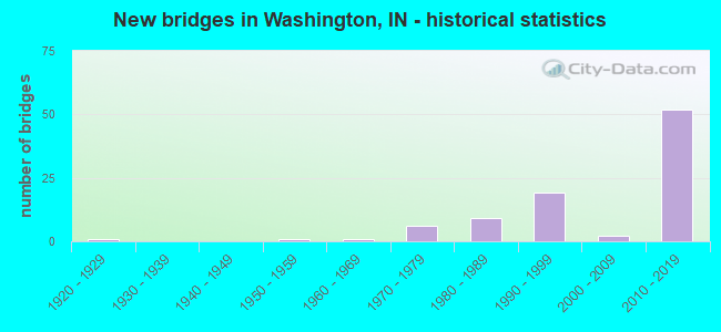
- New bridges - historical statistics
- 11920-1929
- 11950-1959
- 11960-1969
- 61970-1979
- 91980-1989
- 191990-1999
- 22000-2009
- 522010-2019
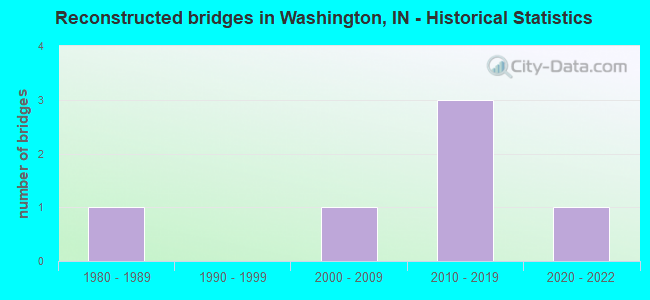
- Reconstructed bridges - Historical Statistics
- 11980-1989
- 01990-1999
- 12000-2009
- 32010-2019
- 12020-2022

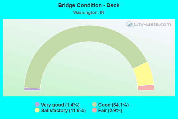
- Bridge Condition - Deck
- 1.4%Very good
- 84.1%Good
- 11.6%Satisfactory
- 2.9%Fair
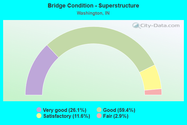
- Bridge Condition - Superstructure
- 26.1%Very good
- 59.4%Good
- 11.6%Satisfactory
- 2.9%Fair
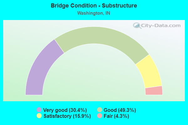
- Bridge Condition - Substructure
- 30.4%Very good
- 49.3%Good
- 15.9%Satisfactory
- 4.3%Fair
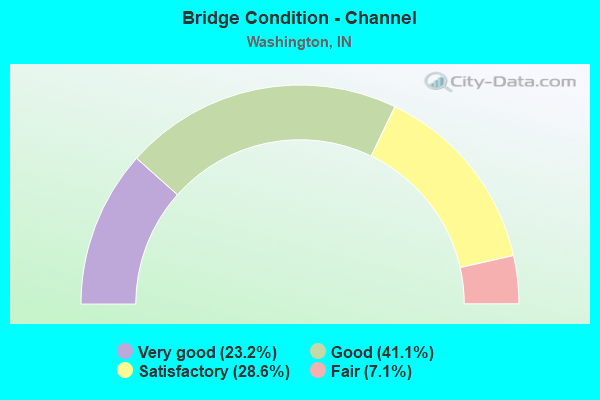
- Bridge Condition - Channel
- 23.2%Very good
- 41.1%Good
- 28.6%Satisfactory
- 7.1%Fair
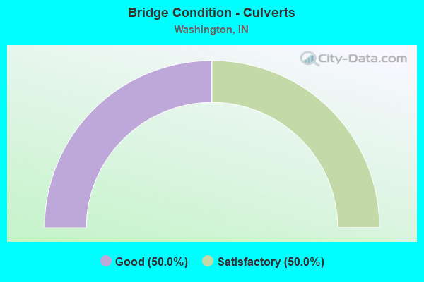
- Bridge Condition - Culverts
- 50.0%Good
- 50.0%Satisfactory
Find on map >> Show street view
Structure Number: 8024, Location: 01.79 N SR 257 (Lat: 38.655900, Lng: -87.120622), Route carried "under" structure: US 50, Year Built: 2012, Structure Length: 0. m, Average Daily Traffic: 6,080 (year 2010), Truck Traffic: 18%, Features Intersected: US 50 WB, Facility Carried by Structure: I-69 SB
Minimum Vertical Clearance: 5.21m (17.09ft), Kilometerpoint: 12.955, Lanes on structure: 2, Lanes under structure: 6, Material/Design: Prestressed concrete continuous, Design/Construction: Tee Beam, Length of Maximum Span: 45.0m (147.6ft)
Find on map >> Show street view
Structure Number: 80258, Location: 00.96 N US 50 (Lat: 38.669619, Lng: -87.120292), Route carried "under" structure: Interstate 69, Year Built: 2012, Structure Length: 0. m, Average Daily Traffic: 7,550 (year 2010), Truck Traffic: 15%, Features Intersected: I-69 SBL, Facility Carried by Structure: CR 100N
Minimum Vertical Clearance: 5.03m (16.50ft), Kilometerpoint: 103.223, Lanes on structure: 2, Lanes under structure: 4, Material/Design: Prestressed concrete continuous, Design/Construction: Tee Beam, Length of Maximum Span: 35.7m (117.1ft)
Find on map >> Show street view
Structure Number: 80258, Location: 00.96 N US 50 (Lat: 38.669619, Lng: -87.120292), Route carried "under" structure: Interstate 69, Year Built: 2012, Structure Length: 0. m, Average Daily Traffic: 7,550 (year 2010), Truck Traffic: 15%, Features Intersected: I-69 NBL, Facility Carried by Structure: CR 100N
Minimum Vertical Clearance: 5.03m (16.50ft), Kilometerpoint: 103.223, Lanes on structure: 2, Lanes under structure: 4, Material/Design: Prestressed concrete continuous, Design/Construction: Tee Beam, Length of Maximum Span: 35.7m (117.1ft)
Find on map >> Show street view
Structure Number: 80264, Location: 02.00 N US 50 (Lat: 38.684089, Lng: -87.120256), Route carried "under" structure: Interstate 69, Year Built: 2012, Structure Length: 0. m, Average Daily Traffic: 7,550 (year 2010), Truck Traffic: 15%, Features Intersected: I69 SBL, Facility Carried by Structure: CR 200N
Minimum Vertical Clearance: 5.03m (16.50ft), Kilometerpoint: 102.837, Lanes on structure: 2, Lanes under structure: 4, Material/Design: Prestressed concrete continuous, Design/Construction: Tee Beam, Length of Maximum Span: 33.7m (110.6ft)
Find on map >> Show street view
Structure Number: 80264, Location: 02.00 N US 50 (Lat: 38.684089, Lng: -87.120256), Route carried "under" structure: Interstate 69, Year Built: 2012, Structure Length: 0. m, Average Daily Traffic: 7,550 (year 2010), Truck Traffic: 15%, Features Intersected: I69 NBL, Facility Carried by Structure: CR 200N
Minimum Vertical Clearance: 5.03m (16.50ft), Kilometerpoint: 102.837, Lanes on structure: 2, Lanes under structure: 4, Material/Design: Prestressed concrete continuous, Design/Construction: Tee Beam, Length of Maximum Span: 33.7m (110.6ft)