Bridge Statistics for Waverly, Iowa (IA)
Condition, Traffic, Stress, Structural Evaluation, Project Costs
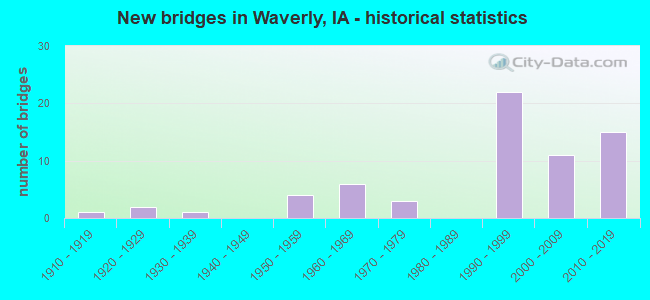
- New bridges - historical statistics
- 11910-1919
- 21920-1929
- 11930-1939
- 41950-1959
- 61960-1969
- 31970-1979
- 221990-1999
- 112000-2009
- 152010-2019
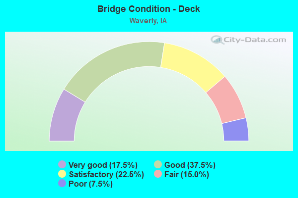
- Bridge Condition - Deck
- 17.5%Very good
- 37.5%Good
- 22.5%Satisfactory
- 15.0%Fair
- 7.5%Poor
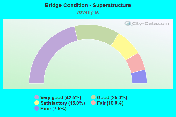
- Bridge Condition - Superstructure
- 42.5%Very good
- 25.0%Good
- 15.0%Satisfactory
- 10.0%Fair
- 7.5%Poor
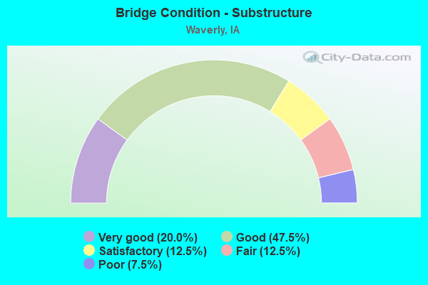
- Bridge Condition - Substructure
- 20.0%Very good
- 47.5%Good
- 12.5%Satisfactory
- 12.5%Fair
- 7.5%Poor
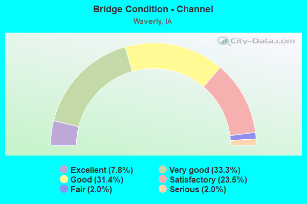
- Bridge Condition - Channel
- 7.8%Excellent
- 33.3%Very good
- 31.4%Good
- 23.5%Satisfactory
- 2.0%Fair
- 2.0%Serious
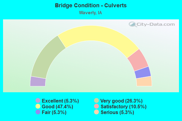
- Bridge Condition - Culverts
- 5.3%Excellent
- 26.3%Very good
- 47.4%Good
- 10.5%Satisfactory
- 5.3%Fair
- 5.3%Serious
Find on map >> Show street view
Structure Number: 502301, Location: Int of 6th Ave/2st SW (Lat: 42.720028, Lng: -92.473097), Route carried "on" structure: City street , Year Built: 2015, Status: Open, Structure Length: 1.38m (4.53ft), Average Daily Traffic: 183 (year 1975), Average Future Daily Traffic: 183 (year 2041), Design Load: HL 93, Features Intersected: SMALL STREAM, Facility Carried by Structure: 2ND ST SW
Minimum Vertical Clearance: 30+ m (98+ ft), Kilometerpoint: 0.154, Lanes on structure: 2, Owner: City or Municipal Highway Agency, Approaching Roadway Width: 10.7m (35.1ft), Skew: 4 degrees, Material/Design: Concrete continuous, Design/Construction: Culvert, Number Of Spans In Main Unit: 3, Length of Maximum Span: 4.3m (14.1ft)
Condition: Channel: Very good, Culverts: Very good, Operating Rating: 42.8 metric tons, Method Used To Determine Operating Rating: Load and Resistance Factor Rating (LRFR) rating reported by rating factor(RF) method using HL-93 loadings, Inventory Rating: 33.0 metric tons, Method Used To Determine Inventory Rating: Load and Resistance Factor Rating (LRFR) rating reported by rating factor(RF) method using HL-93 loadings, Structural Evaluation: Equal to present desirable criteria, Waterway Adequacy: Equal to present desirable criteria, Approach Roadway Alignment: Equal to present minimum criteria, Designated Inspection Frequency: Every 24 months, Inspection Date: March 2021
Find on map >> Show street view
Structure Number: 505325, Location: Int 3rd St/3rd Ave SW (Lat: 42.722831, Lng: -92.474639), Route carried "on" structure: City street , Year Built: 2015, Status: Open, Structure Length: 1.02m (3.35ft), Average Daily Traffic: 270 (year 2017), Average Future Daily Traffic: 270 (year 2041), Design Load: HL 93, Features Intersected: DRY RUN CREEK, Facility Carried by Structure: 3RD AVE SW
Minimum Vertical Clearance: 30+ m (98+ ft), Kilometerpoint: 0.705, Lanes on structure: 2, Owner: City or Municipal Highway Agency, Approaching Roadway Width: 10.7m (35.1ft), Skew: 2 degrees, Material/Design: Concrete continuous, Design/Construction: Culvert, Number Of Spans In Main Unit: 3, Length of Maximum Span: 3.1m (10.2ft)
Condition: Channel: Very good, Culverts: Good, Operating Rating: 42.8 metric tons, Method Used To Determine Operating Rating: Load and Resistance Factor Rating (LRFR) rating reported by rating factor(RF) method using HL-93 loadings, Inventory Rating: 33.0 metric tons, Method Used To Determine Inventory Rating: Load and Resistance Factor Rating (LRFR) rating reported by rating factor(RF) method using HL-93 loadings, Structural Evaluation: Better than present minimum criteria, Waterway Adequacy: Superior to present desirable criteria, Approach Roadway Alignment: Equal to present minimum criteria, Designated Inspection Frequency: Every 24 months, Inspection Date: March 2021
Find on map >> Show street view
Structure Number: 50533, Location: 0.2 Mi E of 4th St SW (Lat: 42.720933, Lng: -92.473781), Route carried "on" structure: City street , Year Built: 2015, Status: Open, Structure Length: 1.19m (3.90ft), Average Daily Traffic: 627 (year 1998), Average Future Daily Traffic: 627 (year 2041), Design Load: HL 93, Features Intersected: DRY RUN CREEK, Facility Carried by Structure: 5TH AVE SW
Minimum Vertical Clearance: 30+ m (98+ ft), Kilometerpoint: 0.550, Lanes on structure: 2, Owner: City or Municipal Highway Agency, Approaching Roadway Width: 9.4m (30.8ft), Skew: 3 degrees, Material/Design: Concrete continuous, Design/Construction: Culvert, Number Of Spans In Main Unit: 3, Length of Maximum Span: 3.7m (12.1ft)
Condition: Channel: Very good, Culverts: Very good, Operating Rating: 42.8 metric tons, Method Used To Determine Operating Rating: Load and Resistance Factor Rating (LRFR) rating reported by rating factor(RF) method using HL-93 loadings, Inventory Rating: 33.0 metric tons, Method Used To Determine Inventory Rating: Load and Resistance Factor Rating (LRFR) rating reported by rating factor(RF) method using HL-93 loadings, Structural Evaluation: Equal to present desirable criteria, Waterway Adequacy: Superior to present desirable criteria, Approach Roadway Alignment: Equal to present minimum criteria, Designated Inspection Frequency: Every 24 months, Inspection Date: March 2021
Find on map >> Show street view
Structure Number: 505335, Location: 100' E of 6th Ave NW (Lat: 42.726717, Lng: -92.477906), Route carried "on" structure: City street , Year Built: 2015, Status: Open, Structure Length: 0.97m (3.18ft), Average Daily Traffic: 300 (year 1975), Average Future Daily Traffic: 300 (year 2041), Design Load: HL 93, Features Intersected: DRY RUN CREEK, Facility Carried by Structure: 1ST AVE NW
Minimum Vertical Clearance: 30+ m (98+ ft), Kilometerpoint: 1.519, Lanes on structure: 2, Owner: City or Municipal Highway Agency, Approaching Roadway Width: 10.1m (33.1ft), Skew: 1 degrees, Material/Design: Concrete continuous, Design/Construction: Culvert, Number Of Spans In Main Unit: 3, Length of Maximum Span: 3.0m (9.8ft)
Condition: Channel: Very good, Culverts: Good, Operating Rating: 42.8 metric tons, Method Used To Determine Operating Rating: Load and Resistance Factor Rating (LRFR) rating reported by rating factor(RF) method using HL-93 loadings, Inventory Rating: 33.0 metric tons, Method Used To Determine Inventory Rating: Load and Resistance Factor Rating (LRFR) rating reported by rating factor(RF) method using HL-93 loadings, Structural Evaluation: Better than present minimum criteria, Waterway Adequacy: Superior to present desirable criteria, Approach Roadway Alignment: Equal to present minimum criteria, Designated Inspection Frequency: Every 24 months, Inspection Date: March 2021, Deck Structure Type: Concrete Cast-file-Place, Wearing Surface/Protective System: Wearing Surface: Monolithic Concrete
Find on map >> Show street view
Structure Number: 505355, Location: BETWEEN 5TH & 6TH ST NW (Lat: 42.728625, Lng: -92.477681), Route carried "on" structure: City street , Year Built: 2016, Status: Open, Structure Length: 1.14m (3.74ft), Average Daily Traffic: 350 (year 1975), Average Future Daily Traffic: 350 (year 2041), Design Load: HL 93, Features Intersected: DRY RUN CREEK, Facility Carried by Structure: 3RD AVE NW
Minimum Vertical Clearance: 30+ m (98+ ft), Kilometerpoint: 1.262, Lanes on structure: 2, Owner: City or Municipal Highway Agency, Approaching Roadway Width: 9.4m (30.8ft), Material/Design: Concrete continuous, Design/Construction: Culvert, Number Of Spans In Main Unit: 3, Length of Maximum Span: 3.7m (12.1ft)
Condition: Channel: Very good, Culverts: Good, Operating Rating: 43.7 metric tons, Method Used To Determine Operating Rating: Load and Resistance Factor Rating (LRFR) rating reported by rating factor(RF) method using HL-93 loadings, Inventory Rating: 33.7 metric tons, Method Used To Determine Inventory Rating: Load and Resistance Factor Rating (LRFR) rating reported by rating factor(RF) method using HL-93 loadings, Structural Evaluation: Better than present minimum criteria, Waterway Adequacy: Equal to present desirable criteria, Approach Roadway Alignment: Equal to present minimum criteria, Designated Inspection Frequency: Every 24 months, Inspection Date: March 2021
Find on map >> Show street view
Structure Number: 50538, Location: 0.5 MI E OF BREMER RD (Lat: 42.730258, Lng: -92.444756), Route carried "on" structure: City street , Year Built: 2016, Status: Open, Structure Length: 1.14m (3.74ft), Average Daily Traffic: 120 (year 2017), Average Future Daily Traffic: 120 (year 2041), Design Load: HL 93, Features Intersected: DRAINAGE DITCH, Facility Carried by Structure: 5TH AVE NE
Minimum Vertical Clearance: 30+ m (98+ ft), Kilometerpoint: 0.888, Lanes on structure: 2, Owner: City or Municipal Highway Agency, Approaching Roadway Width: 11.0m (36.1ft), Material/Design: Concrete continuous, Design/Construction: Culvert, Number Of Spans In Main Unit: 3, Length of Maximum Span: 3.7m (12.1ft)
Condition: Channel: Very good, Culverts: Very good, Operating Rating: 43.7 metric tons, Method Used To Determine Operating Rating: Load and Resistance Factor Rating (LRFR) rating reported by rating factor(RF) method using HL-93 loadings, Inventory Rating: 33.7 metric tons, Method Used To Determine Inventory Rating: Load and Resistance Factor Rating (LRFR) rating reported by rating factor(RF) method using HL-93 loadings, Structural Evaluation: Equal to present desirable criteria, Waterway Adequacy: Equal to present desirable criteria, Approach Roadway Alignment: Equal to present desirable criteria, Designated Inspection Frequency: Every 24 months, Inspection Date: March 2021
Find on map >> Show street view
Structure Number: 505605, Location: 000000000 (Lat: 42.714344, Lng: -92.459011), Route carried "on" structure: City street , Year Built: 2019, Status: Open, Structure Length: 25.18m (82.61ft), Average Daily Traffic: 151 (year 2019), Average Future Daily Traffic: 151 (year 2041), Design Load: HL 93, Features Intersected: CEDAR RIVER, Facility Carried by Structure: CEDAR RIVER PKWY
Minimum Vertical Clearance: 30+ m (98+ ft), Kilometerpoint: 1.379, Lanes on structure: 2, Owner: City or Municipal Highway Agency, Approaching Roadway Width: 14.6m (47.9ft), Material/Design: Prestressed concrete, Design/Construction: Stringer/Multi-beam, Number Of Spans In Main Unit: 6, Length of Maximum Span: 41.8m (137.1ft), Curb or Sidewalk Widths: Left: 4.3m (14.1ft), Right: 0.0m, Curb-To-Curb Width: 9.8m (32.2ft), Out-to-Out Width: 14.9m (48.9ft)
Condition: Deck: Good, Superstructure: Very good, Substructure: Very good, Channel: Very good, Operating Rating: 43.7 metric tons, Method Used To Determine Operating Rating: Load and Resistance Factor Rating (LRFR) rating reported by rating factor(RF) method using HL-93 loadings, Inventory Rating: 34.0 metric tons, Method Used To Determine Inventory Rating: Load and Resistance Factor Rating (LRFR) rating reported by rating factor(RF) method using HL-93 loadings, Structural Evaluation: Equal to present desirable criteria, Deck Geometry: Better than present minimum criteria, Waterway Adequacy: Superior to present desirable criteria, Approach Roadway Alignment: Equal to present desirable criteria, Designated Inspection Frequency: Every 24 months, Inspection Date: April 2021, Deck Structure Type: Concrete Cast-file-Place, Wearing Surface/Protective System: Wearing Surface: Monolithic Concrete
Find on map >> Show street view
Structure Number: 601725, Location: 1.0 mi. S of Jct. IA #3 (Lat: 42.700564, Lng: -92.534253), Route carried "on" structure: County highway , Year Built: 1997, Status: Open, Structure Length: 6.86m (22.51ft), Average Daily Traffic: 200 (year 2017), Average Future Daily Traffic: 200 (year 2041), Design Load: HS 20+Mod, Features Intersected: US 218, Facility Carried by Structure: 240TH STREET
Minimum Vertical Clearance: 30+ m (98+ ft), Kilometerpoint: 0.420, Lanes on structure: 2, Lanes under structure: 4, Owner: State Highway Agency, Approaching Roadway Width: 9.1m (29.9ft), Material/Design: Prestressed concrete, Design/Construction: Stringer/Multi-beam, Number Of Spans In Main Unit: 2, Length of Maximum Span: 33.8m (110.9ft), Curb-To-Curb Width: 9.1m (29.9ft), Out-to-Out Width: 10.1m (33.1ft)
Condition: Deck: Good, Superstructure: Good, Substructure: Very good, Operating Rating: 90.5 metric tons, Method Used To Determine Operating Rating: Load Factor (LF), Inventory Rating: 41.7 metric tons, Method Used To Determine Inventory Rating: Load Factor (LF), Structural Evaluation: Better than present minimum criteria, Deck Geometry: Equal to present minimum criteria, Underclear: Somewhat better than minimum adequacy, Approach Roadway Alignment: Equal to present minimum criteria, Designated Inspection Frequency: Every 24 months, Inspection Date: Febuary 2021, Deck Structure Type: Concrete Cast-file-Place, Wearing Surface/Protective System: Wearing Surface: Monolithic Concrete, Deck Protection: Epoxy Coated Reinforcing
Find on map >> Show street view
Structure Number: 60173, Location: 0.7 Mi. S of Jct. IA #3 (Lat: 42.704983, Lng: -92.533886), Route carried "on" structure: US 218, Year Built: 1996, Status: Open, Structure Length: 5.61m (18.41ft), Average Daily Traffic: 4,500 (year 2020), Truck Traffic: 26%, Average Future Daily Traffic: 4,500 (year 2041), Design Load: HS 20, Features Intersected: OVERFLOW AVE. SAINTS LAK
Minimum Vertical Clearance: 30+ m (98+ ft), Kilometerpoint: 324.532, Lanes on structure: 2, Base Highway Network: Yes, Owner: State Highway Agency, Approaching Roadway Width: 12.2m (40.0ft), Material/Design: Prestressed concrete, Design/Construction: Stringer/Multi-beam, Number Of Spans In Main Unit: 3, Length of Maximum Span: 21.0m (68.9ft), Curb-To-Curb Width: 12.3m (40.4ft), Out-to-Out Width: 13.2m (43.3ft)
Condition: Deck: Good, Superstructure: Very good, Substructure: Good, Channel: Excellent, Operating Rating: 60.3 metric tons, Method Used To Determine Operating Rating: Load Factor (LF), Inventory Rating: 36.1 metric tons, Method Used To Determine Inventory Rating: Load Factor (LF), Structural Evaluation: Better than present minimum criteria, Deck Geometry: Better than present minimum criteria, Waterway Adequacy: Equal to present desirable criteria, Approach Roadway Alignment: Equal to present desirable criteria, Designated Inspection Frequency: Every 24 months, Inspection Date: March 2021, Deck Structure Type: Concrete Cast-file-Place, Wearing Surface/Protective System: Wearing Surface: Monolithic Concrete, Deck Protection: Epoxy Coated Reinforcing
Find on map >> Show street view
Structure Number: 601732, Location: 0.7 mi. S of Jct. Ia. #3 (Lat: 42.705478, Lng: -92.534228), Route carried "on" structure: US 218, Year Built: 1996, Status: Open, Structure Length: 5.61m (18.41ft), Average Daily Traffic: 4,500 (year 2020), Truck Traffic: 26%, Average Future Daily Traffic: 4,500 (year 2041), Design Load: HS 20, Features Intersected: OVERFLOW AVE. SAINTS LAK
Minimum Vertical Clearance: 30+ m (98+ ft), Kilometerpoint: 114.119, Lanes on structure: 2, Owner: State Highway Agency, Approaching Roadway Width: 12.8m (42.0ft), Material/Design: Prestressed concrete, Design/Construction: Stringer/Multi-beam, Number Of Spans In Main Unit: 3, Length of Maximum Span: 21.0m (68.9ft), Curb-To-Curb Width: 12.3m (40.4ft), Out-to-Out Width: 13.2m (43.3ft)
Condition: Deck: Good, Superstructure: Very good, Substructure: Good, Channel: Very good, Operating Rating: 60.4 metric tons, Method Used To Determine Operating Rating: Load Factor (LF), Inventory Rating: 36.3 metric tons, Method Used To Determine Inventory Rating: Load Factor (LF), Structural Evaluation: Better than present minimum criteria, Deck Geometry: Better than present minimum criteria, Waterway Adequacy: Equal to present desirable criteria, Approach Roadway Alignment: Equal to present desirable criteria, Designated Inspection Frequency: Every 24 months, Inspection Date: March 2021, Deck Structure Type: Concrete Cast-file-Place, Wearing Surface/Protective System: Wearing Surface: Monolithic Concrete, Deck Protection: Epoxy Coated Reinforcing
Find on map >> Show street view
Structure Number: 60174, Location: 1.1 MI. N OF JCT. IA 3 (Lat: 42.730931, Lng: -92.533428), Route carried "on" structure: US 218, Year Built: 1996, Status: Open, Structure Length: 0.85m (2.79ft), Average Daily Traffic: 7,800 (year 2020), Truck Traffic: 29%, Average Future Daily Traffic: 7,800 (year 2041), Design Load: HS 20, Features Intersected: TRIB-SHELL ROCK RIVER
Minimum Vertical Clearance: 30+ m (98+ ft), Kilometerpoint: 327.416, Lanes on structure: 4, Base Highway Network: Yes, Owner: State Highway Agency, Approaching Roadway Width: 27.4m (89.9ft), Skew: 23 degrees, Material/Design: Concrete continuous, Design/Construction: Culvert, Number Of Spans In Main Unit: 2, Length of Maximum Span: 4.0m (13.1ft)
Condition: Channel: Very good, Culverts: Satisfactory, Operating Rating: 50.7 metric tons, Method Used To Determine Operating Rating: Load Factor (LF), Inventory Rating: 30.4 metric tons, Method Used To Determine Inventory Rating: Load Factor (LF), Structural Evaluation: Equal to present minimum criteria, Waterway Adequacy: Equal to present desirable criteria, Approach Roadway Alignment: Equal to present desirable criteria, Designated Inspection Frequency: Every 24 months, Inspection Date: March 2021
Find on map >> Show street view
Structure Number: 601775, Location: 2.0 MI. S JCT. IOWA #3 (Lat: 42.693847, Lng: -92.520353), Route carried "on" structure: US 218, Year Built: 1996, Status: Open, Structure Length: 0.76m (2.49ft), Average Daily Traffic: 9,000 (year 2020), Truck Traffic: 26%, Average Future Daily Traffic: 9,000 (year 2041), Design Load: HS 20+Mod, Features Intersected: TRIB TO SHELL ROCK RIVER
Minimum Vertical Clearance: 30+ m (98+ ft), Kilometerpoint: 322.503, Lanes on structure: 4, Base Highway Network: Yes, Owner: State Highway Agency, Approaching Roadway Width: 24.4m (80.1ft), Skew: 20 degrees, Material/Design: Concrete continuous, Design/Construction: Culvert, Number Of Spans In Main Unit: 2, Length of Maximum Span: 3.7m (12.1ft)
Condition: Channel: Good, Culverts: Good, Operating Rating: 47.3 metric tons, Method Used To Determine Operating Rating: Load and Resistance Factor Rating (LRFR) rating reported by rating factor(RF) method using HL-93 loadings, Inventory Rating: 28.2 metric tons, Method Used To Determine Inventory Rating: Load and Resistance Factor Rating (LRFR) rating reported by rating factor(RF) method using HL-93 loadings, Structural Evaluation: Better than present minimum criteria, Waterway Adequacy: Equal to present desirable criteria, Approach Roadway Alignment: Equal to present desirable criteria, Designated Inspection Frequency: Every 24 months, Inspection Date: March 2021
Find on map >> Show street view
Structure Number: 601945, Location: 4.3 MI. S OF JCT. IA 3 (Lat: 42.691611, Lng: -92.477331), Route carried "on" structure: Ramp US 218, Year Built: 1997, Status: Open, Structure Length: 8.78m (28.81ft), Average Daily Traffic: 190 (year 2020), Truck Traffic: 9%, Average Future Daily Traffic: 190 (year 2040), Design Load: HS 20, Features Intersected: US 218
Minimum Vertical Clearance: 30+ m (98+ ft), Kilometerpoint: 0.784, Lanes on structure: 1, Lanes under structure: 4, Owner: State Highway Agency, Approaching Roadway Width: 9.1m (29.9ft), Skew: 2 degrees, Material/Design: Prestressed concrete, Design/Construction: Stringer/Multi-beam, Number Of Spans In Main Unit: 4, Length of Maximum Span: 31.1m (102.0ft), Curb-To-Curb Width: 7.9m (25.9ft), Out-to-Out Width: 8.8m (28.9ft)
Condition: Deck: Good, Superstructure: Very good, Substructure: Good, Operating Rating: 89.2 metric tons, Method Used To Determine Operating Rating: Load Factor (LF), Inventory Rating: 44.9 metric tons, Method Used To Determine Inventory Rating: Load Factor (LF), Structural Evaluation: Better than present minimum criteria, Deck Geometry: Equal to present desirable criteria, Underclear: Superior to present desirable criteria, Approach Roadway Alignment: Equal to present desirable criteria, Designated Inspection Frequency: Every 24 months, Inspection Date: December 2020, Deck Structure Type: Concrete Cast-file-Place, Wearing Surface/Protective System: Wearing Surface: Monolithic Concrete, Deck Protection: Epoxy Coated Reinforcing
Find on map >> Show street view
Structure Number: 60195, Location: 4.2 MI. S OF JCT. IA 3 (Lat: 42.692422, Lng: -92.477150), Route carried "on" structure: State highway 116, Year Built: 1997, Status: Open, Structure Length: 8.78m (28.81ft), Average Daily Traffic: 2,950 (year 2020), Truck Traffic: 4%, Average Future Daily Traffic: 2,950 (year 2040), Design Load: HS 20, Features Intersected: US 218
Minimum Vertical Clearance: 30+ m (98+ ft), Kilometerpoint: 3.730, Lanes on structure: 1, Lanes under structure: 5, Owner: State Highway Agency, Approaching Roadway Width: 9.1m (29.9ft), Skew: 2 degrees, Material/Design: Prestressed concrete, Design/Construction: Stringer/Multi-beam, Number Of Spans In Main Unit: 1, Length of Maximum Span: 30.8m (101.0ft), Curb-To-Curb Width: 7.8m (25.6ft), Out-to-Out Width: 8.5m (27.9ft)
Condition: Deck: Good, Superstructure: Very good, Substructure: Very good, Operating Rating: 89.4 metric tons, Method Used To Determine Operating Rating: Load Factor (LF), Inventory Rating: 53.6 metric tons, Method Used To Determine Inventory Rating: Load Factor (LF), Structural Evaluation: Equal to present desirable criteria, Deck Geometry: High priority of replacement, Underclear: Superior to present desirable criteria, Approach Roadway Alignment: Equal to present desirable criteria, Designated Inspection Frequency: Every 24 months, Inspection Date: December 2020, Deck Structure Type: Concrete Cast-file-Place, Wearing Surface/Protective System: Wearing Surface: Monolithic Concrete, Deck Protection: Epoxy Coated Reinforcing
Find on map >> Show street view
Structure Number: 601955, Location: 2.0 MI. N OF JCT. IA. 3 (Lat: 42.744647, Lng: -92.534628), Route carried "on" structure: County highway , Year Built: 1996, Status: Open, Structure Length: 6.86m (22.51ft), Average Daily Traffic: 910 (year 2021), Truck Traffic: 5%, Average Future Daily Traffic: 910 (year 2041), Design Load: HS 20, Features Intersected: US 218, Facility Carried by Structure: 210TH ST
Minimum Vertical Clearance: 30+ m (98+ ft), Kilometerpoint: 1.622, Lanes on structure: 2, Lanes under structure: 4, Base Highway Network: Yes, Owner: State Highway Agency, Approaching Roadway Width: 12.2m (40.0ft), Material/Design: Prestressed concrete, Design/Construction: Stringer/Multi-beam, Number Of Spans In Main Unit: 2, Length of Maximum Span: 33.8m (110.9ft), Curb-To-Curb Width: 10.9m (35.8ft), Out-to-Out Width: 11.9m (39.0ft)
Condition: Deck: Good, Superstructure: Very good, Substructure: Good, Operating Rating: 90.5 metric tons, Method Used To Determine Operating Rating: Load Factor (LF), Inventory Rating: 60.1 metric tons, Method Used To Determine Inventory Rating: Load Factor (LF), Structural Evaluation: Better than present minimum criteria, Deck Geometry: Equal to present minimum criteria, Underclear: Somewhat better than minimum adequacy, Approach Roadway Alignment: Equal to present desirable criteria, Designated Inspection Frequency: Every 24 months, Inspection Date: Febuary 2021, Deck Structure Type: Concrete Cast-file-Place, Wearing Surface/Protective System: Wearing Surface: Monolithic Concrete, Deck Protection: Epoxy Coated Reinforcing
Find on map >> Show street view
Structure Number: 604462, Location: 0.1 MI.S.OF JCT.3 (Lat: 42.723761, Lng: -92.475650), Route carried "on" structure: State highway 116, Year Built: 2015, Status: Open, Structure Length: 1.37m (4.49ft), Average Daily Traffic: 12,500 (year 2020), Truck Traffic: 3%, Average Future Daily Traffic: 12,500 (year 2040), Design Load: HL 93, Features Intersected: DRY RUN CREEK
Minimum Vertical Clearance: 30+ m (98+ ft), Kilometerpoint: 4.234, Lanes on structure: 2, Base Highway Network: Yes, Owner: State Highway Agency, Approaching Roadway Width: 10.4m (34.1ft), Skew: 4 degrees, Material/Design: Concrete continuous, Design/Construction: Culvert, Number Of Spans In Main Unit: 3, Length of Maximum Span: 3.7m (12.1ft)
Condition: Channel: Excellent, Culverts: Very good, Operating Rating: 42.1 metric tons, Method Used To Determine Operating Rating: Assigned ratings based on Load and Resistance Factor Design (LRFD) reported by rating factor (RF) using HL93 loadings, Inventory Rating: 32.4 metric tons, Method Used To Determine Inventory Rating: Assigned ratings based on Load and Resistance Factor Design (LRFD) reported by rating factor (RF) using HL93 loadings, Structural Evaluation: Equal to present desirable criteria, Waterway Adequacy: Superior to present desirable criteria, Approach Roadway Alignment: Equal to present desirable criteria, Designated Inspection Frequency: Every 24 months, Inspection Date: April 2020
Find on map >> Show street view
Structure Number: 60668, Location: At the Jct. of Iowa #3 (Lat: 42.714828, Lng: -92.534347), Route carried "on" structure: US 218, Year Built: 1996, Status: Open, Structure Length: 6.13m (20.11ft), Average Daily Traffic: 3,400 (year 2020), Truck Traffic: 30%, Average Future Daily Traffic: 3,400 (year 2041), Design Load: HS 20, Features Intersected: IA 3
Minimum Vertical Clearance: 30+ m (98+ ft), Kilometerpoint: 325.627, Lanes on structure: 2, Lanes under structure: 2, Base Highway Network: Yes, Owner: State Highway Agency, Approaching Roadway Width: 12.2m (40.0ft), Material/Design: Prestressed concrete, Design/Construction: Stringer/Multi-beam, Number Of Spans In Main Unit: 3, Length of Maximum Span: 32.6m (107.0ft), Curb-To-Curb Width: 12.2m (40.0ft), Out-to-Out Width: 13.2m (43.3ft)
Condition: Deck: Good, Superstructure: Good, Substructure: Good, Operating Rating: 63.9 metric tons, Method Used To Determine Operating Rating: Load Factor (LF), Inventory Rating: 38.4 metric tons, Method Used To Determine Inventory Rating: Load Factor (LF), Structural Evaluation: Better than present minimum criteria, Deck Geometry: Better than present minimum criteria, Underclear: Superior to present desirable criteria, Approach Roadway Alignment: Equal to present desirable criteria, Designated Inspection Frequency: Every 24 months, Inspection Date: Febuary 2021, Deck Structure Type: Concrete Cast-file-Place, Wearing Surface/Protective System: Wearing Surface: Monolithic Concrete, Deck Protection: Epoxy Coated Reinforcing
Find on map >> Show street view
Structure Number: 606685, Location: AT THE JCT. OF IA. 3 (Lat: 42.715378, Lng: -92.534669), Route carried "on" structure: US 218, Year Built: 1996, Status: Open, Structure Length: 6.13m (20.11ft), Average Daily Traffic: 3,400 (year 2020), Truck Traffic: 30%, Average Future Daily Traffic: 3,400 (year 2041), Design Load: HS 20, Features Intersected: IA 3
Minimum Vertical Clearance: 30+ m (98+ ft), Kilometerpoint: 113.018, Lanes on structure: 2, Lanes under structure: 2, Owner: State Highway Agency, Approaching Roadway Width: 12.2m (40.0ft), Material/Design: Prestressed concrete, Design/Construction: Stringer/Multi-beam, Number Of Spans In Main Unit: 3, Length of Maximum Span: 32.6m (107.0ft), Curb-To-Curb Width: 12.1m (39.7ft), Out-to-Out Width: 13.2m (43.3ft)
Condition: Deck: Good, Superstructure: Very good, Substructure: Good, Operating Rating: 71.2 metric tons, Method Used To Determine Operating Rating: Load Factor (LF), Inventory Rating: 42.7 metric tons, Method Used To Determine Inventory Rating: Load Factor (LF), Structural Evaluation: Better than present minimum criteria, Deck Geometry: Better than present minimum criteria, Underclear: Superior to present desirable criteria, Approach Roadway Alignment: Equal to present desirable criteria, Designated Inspection Frequency: Every 24 months, Inspection Date: Febuary 2021, Deck Structure Type: Concrete Cast-file-Place, Wearing Surface/Protective System: Wearing Surface: Monolithic Concrete, Deck Protection: Epoxy Coated Reinforcing
Find on map >> Show street view
Structure Number: 601725, Location: 1.0 mi. S of Jct. IA #3 (Lat: 42.700564, Lng: -92.534253), Route carried "under" structure: US 218, Year Built: 1997, Structure Length: 0. m, Average Daily Traffic: 9,000 (year 2020), Truck Traffic: 26%, Features Intersected: US 218, Facility Carried by Structure: 240TH STREET
Minimum Vertical Clearance: 30+ m (98+ ft), Kilometerpoint: 324.040, Lanes on structure: 2, Lanes under structure: 4, Material/Design: Prestressed concrete, Design/Construction: Stringer/Multi-beam, Length of Maximum Span: 33.8m (110.9ft)
Find on map >> Show street view
Structure Number: 601945, Location: 4.3 MI. S OF JCT. IA 3 (Lat: 42.691611, Lng: -92.477331), Route carried "under" structure: US 218, Year Built: 1997, Structure Length: 0. m, Average Daily Traffic: 4,250 (year 2020), Truck Traffic: 27%, Features Intersected: US 218
Minimum Vertical Clearance: 30+ m (98+ ft), Kilometerpoint: 318.917, Lanes on structure: 1, Lanes under structure: 4, Material/Design: Prestressed concrete, Design/Construction: Stringer/Multi-beam, Length of Maximum Span: 31.1m (102.0ft)
Find on map >> Show street view
Structure Number: 60195, Location: 4.2 MI. S OF JCT. IA 3 (Lat: 42.692422, Lng: -92.477150), Route carried "under" structure: US 218, Year Built: 1997, Structure Length: 0. m, Average Daily Traffic: 4,250 (year 2020), Truck Traffic: 27%, Features Intersected: US 218, Facility Carried by Structure: IA 116 SB
Minimum Vertical Clearance: 30+ m (98+ ft), Kilometerpoint: 318.938, Lanes on structure: 1, Lanes under structure: 5, Material/Design: Prestressed concrete, Design/Construction: Stringer/Multi-beam, Length of Maximum Span: 30.8m (101.0ft)
Find on map >> Show street view
Structure Number: 601955, Location: 2.0 MI. N OF JCT. IA. 3 (Lat: 42.744647, Lng: -92.534628), Route carried "under" structure: US 218, Year Built: 1996, Structure Length: 0. m, Average Daily Traffic: 7,700 (year 2020), Truck Traffic: 29%, Features Intersected: US 218, Facility Carried by Structure: 210TH ST
Minimum Vertical Clearance: 30+ m (98+ ft), Kilometerpoint: 328.932, Lanes on structure: 2, Lanes under structure: 4, Material/Design: Prestressed concrete, Design/Construction: Stringer/Multi-beam, Length of Maximum Span: 33.8m (110.9ft)
Find on map >> Show street view
Structure Number: 60668, Location: At the Jct. of Iowa #3 (Lat: 42.714828, Lng: -92.534347), Route carried "under" structure: State highway 3, Year Built: 1996, Structure Length: 0. m, Average Daily Traffic: 3,100 (year 2020), Truck Traffic: 7%, Features Intersected: IA 3, Facility Carried by Structure: NB US 218
Minimum Vertical Clearance: 30+ m (98+ ft), Kilometerpoint: 349.852, Lanes on structure: 2, Lanes under structure: 2, Material/Design: Prestressed concrete, Design/Construction: Stringer/Multi-beam, Length of Maximum Span: 32.6m (107.0ft)
Find on map >> Show street view
Structure Number: 606685, Location: AT THE JCT. OF IA. 3 (Lat: 42.715378, Lng: -92.534669), Route carried "under" structure: State highway 3, Year Built: 1996, Structure Length: 0. m, Average Daily Traffic: 3,100 (year 2020), Truck Traffic: 7%, Features Intersected: IA 3, Facility Carried by Structure: SB US 218
Minimum Vertical Clearance: 30+ m (98+ ft), Kilometerpoint: 349.825, Lanes on structure: 2, Lanes under structure: 2, Material/Design: Prestressed concrete, Design/Construction: Stringer/Multi-beam, Length of Maximum Span: 32.6m (107.0ft)