Bridge Statistics for Wentzville, Missouri (MO)
Condition, Traffic, Stress, Structural Evaluation, Project Costs
- National Bridge Inventory (NBI) Statistics
- 69Number of bridges
- 732ft / 223mTotal length
- $2,374,000Total costs
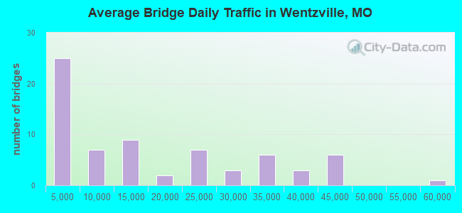
- 1,088,875Total average daily traffic
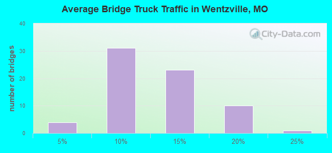
- 120,549Total average daily truck traffic
- National Bridge Inventory (NBI) Registered Bridges for Wentzville
- No street view available for this location
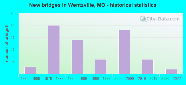
- New bridges - historical statistics
- 31960-1969
- 201970-1979
- 141980-1989
- 61990-1999
- 182000-2009
- 62010-2019
- 22020-2022
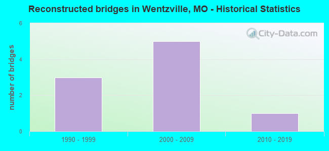
- Reconstructed bridges - Historical Statistics
- 31990-1999
- 52000-2009
- 12010-2019
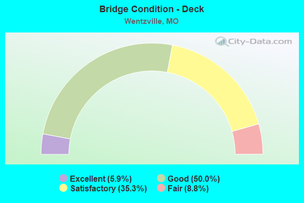
- Bridge Condition - Deck
- 5.9%Excellent
- 50.0%Good
- 35.3%Satisfactory
- 8.8%Fair
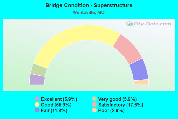
- Bridge Condition - Superstructure
- 5.9%Excellent
- 5.9%Very good
- 55.9%Good
- 17.6%Satisfactory
- 11.8%Fair
- 2.9%Poor
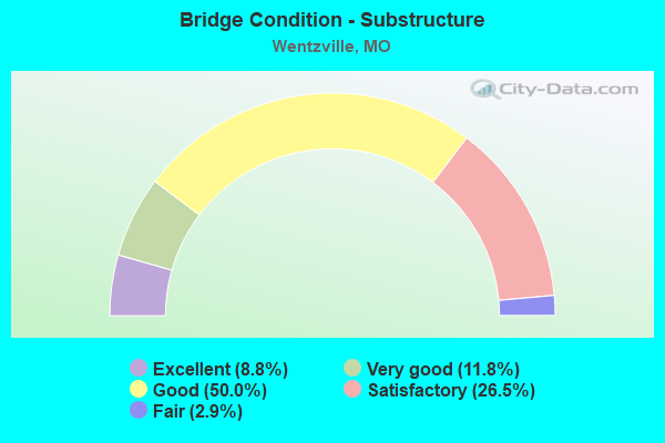
- Bridge Condition - Substructure
- 8.8%Excellent
- 11.8%Very good
- 50.0%Good
- 26.5%Satisfactory
- 2.9%Fair
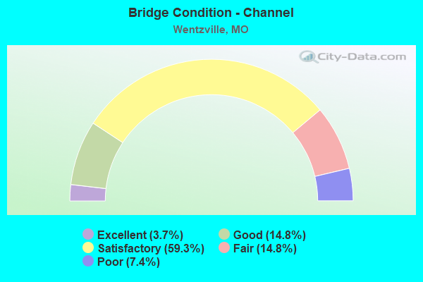
- Bridge Condition - Channel
- 3.7%Excellent
- 14.8%Good
- 59.3%Satisfactory
- 14.8%Fair
- 7.4%Poor
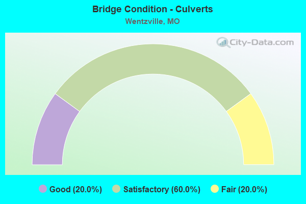
- Bridge Condition - Culverts
- 20.0%Good
- 60.0%Satisfactory
- 20.0%Fair
Find on map >> Show street view
Structure Number: 6271, Location: S 30 T 47 N R 2 E (Lat: 38.806494, Lng: -90.835956), Route carried "on" structure: Interstate 64, Year Built: 1971, Year Reconstructed: 2005, Status: Open, Structure Length: 9.36m (30.71ft), Average Daily Traffic: 32,532 (year 2021), Truck Traffic: 7%, Average Future Daily Traffic: 55,304 (year 2041), Design Load: H 20, Features Intersected: IS 70
Minimum Vertical Clearance: 30+ m (98+ ft), Kilometerpoint: 65.177, Lanes on structure: 2, Lanes under structure: 5, Base Highway Network: Yes, Owner: State Highway Agency, Approaching Roadway Width: 11.6m (38.1ft), Skew: 4 degrees, Material/Design: Steel continuous, Design/Construction: Stringer/Multi-beam, Number Of Spans In Main Unit: 3, Number Of Approach Spans: 1, Length of Maximum Span: 30.2m (99.1ft), Curb-To-Curb Width: 11.6m (38.1ft), Out-to-Out Width: 12.4m (40.7ft)
Condition: Deck: Fair, Superstructure: Poor, Substructure: Satisfactory, Operating Rating: 60.3 metric tons, Method Used To Determine Operating Rating: Load Factor (LF), Inventory Rating: 36.0 metric tons, Method Used To Determine Inventory Rating: Load Factor (LF), Structural Evaluation: Meets minimum limits, Deck Geometry: Equal to present minimum criteria, Underclear: Somewhat better than minimum adequacy, Approach Roadway Alignment: Equal to present desirable criteria, Length Of Structure Improvement: 1.03m (3.38ft), Designated Inspection Frequency: Every 24 months, Other Special Inspection Frequency: Every 24 months, Inspection Date: September 2021, Other Special Inspection Date: March 2021, Bridge Improvement Cost: $841,000, Roadway Improvement Cost: $84,000, Total Project Cost: $1,262,000 ( Estimate for 2022), Deck Structure Type: Concrete Cast-file-Place, Wearing Surface/Protective System: Wearing Surface: Other
Find on map >> Show street view
Structure Number: 639, Location: S 30 T 47 N R 2 E (Lat: 38.806372, Lng: -90.839314), Route carried "on" structure: US 61, Year Built: 1971, Year Reconstructed: 2003, Status: Posted for load, Structure Length: 7.50m (24.61ft), Average Daily Traffic: 20,671 (year 2021), Truck Traffic: 5%, Average Future Daily Traffic: 35,141 (year 2041), Design Load: H 20, Features Intersected: IS 70
Minimum Vertical Clearance: 30+ m (98+ ft), Kilometerpoint: 219.631, Lanes on structure: 3, Lanes under structure: 6, Base Highway Network: Yes, Owner: State Highway Agency, Approaching Roadway Width: 14.0m (45.9ft), Skew: 3 degrees, Material/Design: Steel continuous, Design/Construction: Stringer/Multi-beam, Number Of Spans In Main Unit: 4, Length of Maximum Span: 24.1m (79.1ft), Curb-To-Curb Width: 15.2m (49.9ft), Out-to-Out Width: 16.1m (52.8ft)
Condition: Deck: Fair, Superstructure: Good, Substructure: Good, Operating Rating: 51.3 metric tons, Method Used To Determine Operating Rating: Load Factor (LF), Inventory Rating: 30.6 metric tons, Method Used To Determine Inventory Rating: Load Factor (LF), Structural Evaluation: Better than present minimum criteria, Deck Geometry: Meets minimum limits, Underclear: Somewhat better than minimum adequacy, Approach Roadway Alignment: Equal to present desirable criteria, Designated Inspection Frequency: Every 24 months, Inspection Date: September 2021, Deck Structure Type: Concrete Cast-file-Place, Wearing Surface/Protective System: Wearing Surface: Latex Concrete
Find on map >> Show street view
Structure Number: 12101, Location: S 26 T 47 N R 1 E (Lat: 38.810056, Lng: -90.874772), Route carried "under" structure: Interstate 70, Year Built: 2001, Structure Length: 0. m, Average Daily Traffic: 30,782 (year 2021), Truck Traffic: 18%, Features Intersected: IS 70, Facility Carried by Structure: WENTZVILLE PKWY E
Minimum Vertical Clearance: 5.18m (16.99ft), Kilometerpoint: 335.282, Lanes on structure: 7, Lanes under structure: 2, Material/Design: Steel continuous, Design/Construction: Stringer/Multi-beam, Length of Maximum Span: 34.3m (112.5ft)
Find on map >> Show street view
Structure Number: 12101, Location: S 26 T 47 N R 1 E (Lat: 38.810056, Lng: -90.874772), Route carried "under" structure: Interstate 70, Year Built: 2001, Structure Length: 0. m, Average Daily Traffic: 32,606 (year 2021), Truck Traffic: 18%, Features Intersected: IS 70, Facility Carried by Structure: WENTZVILLE PKWY E
Minimum Vertical Clearance: 5.21m (17.09ft), Kilometerpoint: 67.255, Lanes on structure: 7, Lanes under structure: 2, Material/Design: Steel continuous, Design/Construction: Stringer/Multi-beam, Length of Maximum Span: 34.3m (112.5ft)
Find on map >> Show street view
Structure Number: 1718, Location: S 30 T 47 N R 2 E (Lat: 38.808400, Lng: -90.840236), Route carried "under" structure: Interstate 64, Year Built: 1971, Structure Length: 0. m, Average Daily Traffic: 15,508 (year 2021), Truck Traffic: 9%, Features Intersected: IS 64, Facility Carried by Structure: US 61 S
Minimum Vertical Clearance: 4.98m (16.34ft), Kilometerpoint: 65.668, Lanes on structure: 3, Lanes under structure: 1, Material/Design: Concrete continuous, Design/Construction: Slab, Length of Maximum Span: 15.8m (51.8ft)
Find on map >> Show street view
Structure Number: 2199, Location: S 30 T 47 N R 2 E (Lat: 38.804267, Lng: -90.832319), Route carried "under" structure: Interstate 64, Year Built: 1971, Structure Length: 0. m, Average Daily Traffic: 32,532 (year 2021), Truck Traffic: 7%, Features Intersected: IS 64
Minimum Vertical Clearance: 5.00m (16.40ft), Kilometerpoint: 64.821, Lanes on structure: 2, Lanes under structure: 2, Material/Design: Steel continuous, Design/Construction: Stringer/Multi-beam, Length of Maximum Span: 22.3m (73.2ft)
Find on map >> Show street view
Structure Number: 2402, Location: S 19 T 47 N R 2 E (Lat: 38.812875, Lng: -90.841906), Route carried "under" structure: City street , Year Built: 1973, Structure Length: 0. m, Average Daily Traffic: 2,750 (year 2021), Truck Traffic: 5%, Features Intersected: CST PITMAN AVE, Facility Carried by Structure: US 61 S
Minimum Vertical Clearance: 7.90m (25.92ft), Kilometerpoint: 0.990, Lanes on structure: 2, Lanes under structure: 3, Material/Design: Steel continuous, Design/Construction: Stringer/Multi-beam, Length of Maximum Span: 20.4m (66.9ft)
Find on map >> Show street view
Structure Number: 2402, Location: S 19 T 47 N R 2 E (Lat: 38.812875, Lng: -90.841906), Route carried "under" structure: City street , Year Built: 1973, Structure Length: 0. m, Average Daily Traffic: 8,522 (year 2021), Truck Traffic: 5%, Features Intersected: CST PEARCE BLVD, Facility Carried by Structure: US 61 S
Minimum Vertical Clearance: 7.47m (24.51ft), Kilometerpoint: 0.306, Lanes on structure: 2, Lanes under structure: 2, Material/Design: Steel continuous, Design/Construction: Stringer/Multi-beam, Length of Maximum Span: 20.4m (66.9ft)
Find on map >> Show street view
Structure Number: 2403, Location: S 19 T 47 N R 2 E (Lat: 38.812883, Lng: -90.841569), Route carried "under" structure: City street , Year Built: 1976, Structure Length: 0. m, Average Daily Traffic: 2,750 (year 2021), Truck Traffic: 5%, Features Intersected: CST PITMAN AVE, Facility Carried by Structure: US 61 N
Minimum Vertical Clearance: 7.90m (25.92ft), Kilometerpoint: 1.015, Lanes on structure: 2, Lanes under structure: 3, Material/Design: Steel continuous, Design/Construction: Stringer/Multi-beam, Length of Maximum Span: 19.5m (64.0ft)
Find on map >> Show street view
Structure Number: 2403, Location: S 19 T 47 N R 2 E (Lat: 38.812883, Lng: -90.841569), Route carried "under" structure: City street , Year Built: 1976, Structure Length: 0. m, Average Daily Traffic: 8,522 (year 2021), Truck Traffic: 5%, Features Intersected: CST PEARCE BLVD, Facility Carried by Structure: US 61 N
Minimum Vertical Clearance: 7.39m (24.25ft), Kilometerpoint: 0.000, Lanes on structure: 2, Lanes under structure: 2, Material/Design: Steel continuous, Design/Construction: Stringer/Multi-beam, Length of Maximum Span: 19.5m (64.0ft)
Find on map >> Show street view
Structure Number: 2411, Location: S 24 T 47 N R 1 E (Lat: 38.823136, Lng: -90.849183), Route carried "under" structure: US 61, Year Built: 1973, Structure Length: 0. m, Average Daily Traffic: 25,900 (year 2021), Truck Traffic: 18%, Features Intersected: US 61, Facility Carried by Structure: RT A E
Minimum Vertical Clearance: 5.23m (17.16ft), Kilometerpoint: 416.576, Lanes on structure: 6, Lanes under structure: 2, Material/Design: Steel continuous, Design/Construction: Stringer/Multi-beam, Length of Maximum Span: 28.0m (91.9ft)
Find on map >> Show street view
Structure Number: 2411, Location: S 24 T 47 N R 1 E (Lat: 38.823136, Lng: -90.849183), Route carried "under" structure: US 61, Year Built: 1973, Structure Length: 0. m, Average Daily Traffic: 39,540 (year 2021), Truck Traffic: 15%, Features Intersected: US 61, Facility Carried by Structure: RT A E
Minimum Vertical Clearance: 4.98m (16.34ft), Kilometerpoint: 217.598, Lanes on structure: 6, Lanes under structure: 2, Material/Design: Steel continuous, Design/Construction: Stringer/Multi-beam, Length of Maximum Span: 28.0m (91.9ft)
Find on map >> Show street view
Structure Number: 30074, Location: S 19 T 47 N R 2 E (Lat: 38.811625, Lng: -90.841847), Route carried "under" structure: Ramp State highway , Year Built: 2003, Structure Length: 0. m, Average Daily Traffic: 3,949 (year 2021), Truck Traffic: 5%, Features Intersected: RP PITMAN AVE TO US61S, Facility Carried by Structure: RP US61S TO US40W
Minimum Vertical Clearance: 5.16m (16.93ft), Kilometerpoint: 0.100, Lanes on structure: 1, Lanes under structure: 1, Material/Design: Prestressed concrete continuous, Design/Construction: Tee Beam, Length of Maximum Span: 36.6m (120.1ft)
Find on map >> Show street view
Structure Number: 30074, Location: S 19 T 47 N R 2 E (Lat: 38.811625, Lng: -90.841847), Route carried "under" structure: City street , Year Built: 2003, Structure Length: 0. m, Average Daily Traffic: 8,522 (year 2021), Truck Traffic: 5%, Features Intersected: CST PEARCE BLVD, Facility Carried by Structure: RP US61S TO US40W
Minimum Vertical Clearance: 8.27m (27.13ft), Kilometerpoint: 0.211, Lanes on structure: 1, Lanes under structure: 2, Material/Design: Prestressed concrete continuous, Design/Construction: Tee Beam, Length of Maximum Span: 36.6m (120.1ft)
Find on map >> Show street view
Structure Number: 30074, Location: S 19 T 47 N R 2 E (Lat: 38.811625, Lng: -90.841847), Route carried "under" structure: City street , Year Built: 2003, Structure Length: 0. m, Average Daily Traffic: 2,750 (year 2021), Truck Traffic: 5%, Features Intersected: CST PITMAN AVE, Facility Carried by Structure: RP US61S TO US40W
Minimum Vertical Clearance: 9.91m (32.51ft), Kilometerpoint: 0.951, Lanes on structure: 1, Lanes under structure: 3, Material/Design: Prestressed concrete continuous, Design/Construction: Tee Beam, Length of Maximum Span: 36.6m (120.1ft)
Find on map >> Show street view
Structure Number: 31841, Location: S 29 T 47 N R 2 E (Lat: 38.795981, Lng: -90.819256), Route carried "under" structure: Interstate 64, Year Built: 2009, Structure Length: 0. m, Average Daily Traffic: 31,780 (year 2021), Truck Traffic: 12%, Features Intersected: IS 64, Facility Carried by Structure: PROSPECT RD E
Minimum Vertical Clearance: 5.08m (16.67ft), Kilometerpoint: 2.306, Lanes on structure: 2, Lanes under structure: 2, Material/Design: Prestressed concrete continuous, Design/Construction: Tee Beam, Length of Maximum Span: 34.4m (112.9ft)
Find on map >> Show street view
Structure Number: 31841, Location: S 29 T 47 N R 2 E (Lat: 38.795981, Lng: -90.819256), Route carried "under" structure: Interstate 64, Year Built: 2009, Structure Length: 0. m, Average Daily Traffic: 32,807 (year 2021), Truck Traffic: 7%, Features Intersected: IS 64, Facility Carried by Structure: PROSPECT RD E
Minimum Vertical Clearance: 5.11m (16.77ft), Kilometerpoint: 63.349, Lanes on structure: 2, Lanes under structure: 2, Material/Design: Prestressed concrete continuous, Design/Construction: Tee Beam, Length of Maximum Span: 34.4m (112.9ft)
Find on map >> Show street view
Structure Number: 3464, Location: S 888 T 47 N R 2 E (Lat: 38.809281, Lng: -90.807997), Route carried "under" structure: City street , Year Built: 1982, Structure Length: 0. m, Average Daily Traffic: 2,311 (year 2021), Truck Traffic: 12%, Features Intersected: CST E PITMAN AVE, Facility Carried by Structure: RT A E
Minimum Vertical Clearance: 10.39m (34.09ft), Kilometerpoint: 0.000, Lanes on structure: 4, Lanes under structure: 2, Material/Design: Prestressed concrete continuous, Design/Construction: Stringer/Multi-beam, Length of Maximum Span: 27.1m (88.9ft)
Find on map >> Show street view
Structure Number: 3465, Location: S 888 T 47 N R 2 E (Lat: 38.805403, Lng: -90.807761), Route carried "under" structure: State highway A, Year Built: 1983, Structure Length: 0. m, Average Daily Traffic: 12,540 (year 2021), Truck Traffic: 5%, Features Intersected: RT A, Facility Carried by Structure: IS 70 E
Minimum Vertical Clearance: 5.82m (19.09ft), Kilometerpoint: 5.345, Lanes on structure: 3, Lanes under structure: 4, Material/Design: Prestressed concrete continuous, Design/Construction: Stringer/Multi-beam, Length of Maximum Span: 17.1m (56.1ft)
Find on map >> Show street view
Structure Number: 3466, Location: S 888 T 47 N R 2 E (Lat: 38.805572, Lng: -90.807725), Route carried "under" structure: State highway A, Year Built: 1982, Structure Length: 0. m, Average Daily Traffic: 12,540 (year 2021), Truck Traffic: 5%, Features Intersected: RT A, Facility Carried by Structure: IS 70 W
Minimum Vertical Clearance: 5.16m (16.93ft), Kilometerpoint: 5.329, Lanes on structure: 3, Lanes under structure: 3, Material/Design: Prestressed concrete continuous, Design/Construction: Stringer/Multi-beam, Length of Maximum Span: 17.1m (56.1ft)
Find on map >> Show street view
Structure Number: 3535, Location: S 25 T 47 N R 1 E (Lat: 38.805606, Lng: -90.854686), Route carried "under" structure: State highway Z, Year Built: 1985, Structure Length: 0. m, Average Daily Traffic: 22,071 (year 2021), Truck Traffic: 7%, Features Intersected: RT Z, Facility Carried by Structure: IS 70 E
Minimum Vertical Clearance: 6.02m (19.75ft), Kilometerpoint: 0.129, Lanes on structure: 2, Lanes under structure: 3, Material/Design: Prestressed concrete continuous, Design/Construction: Stringer/Multi-beam, Length of Maximum Span: 18.0m (59.1ft)
Find on map >> Show street view
Structure Number: 3537, Location: S 25 T 47 N R 1 E (Lat: 38.805731, Lng: -90.854639), Route carried "under" structure: State highway Z, Year Built: 1985, Structure Length: 0. m, Average Daily Traffic: 22,071 (year 2021), Truck Traffic: 7%, Features Intersected: RT Z, Facility Carried by Structure: IS 70 W
Minimum Vertical Clearance: 5.39m (17.68ft), Kilometerpoint: 0.116, Lanes on structure: 2, Lanes under structure: 3, Material/Design: Prestressed concrete continuous, Design/Construction: Stringer/Multi-beam, Length of Maximum Span: 18.0m (59.1ft)
Find on map >> Show street view
Structure Number: 35613, Location: S 413 T 47 N R 1 E (Lat: 38.855000, Lng: -90.871389), Route carried "under" structure: US 61, Year Built: 2018, Structure Length: 0. m, Average Daily Traffic: 21,447 (year 2021), Truck Traffic: 16%, Features Intersected: US 61, Facility Carried by Structure: PEINE RD N
Minimum Vertical Clearance: 6.02m (19.75ft), Kilometerpoint: 213.644, Lanes on structure: 3, Lanes under structure: 2, Material/Design: Prestressed concrete, Design/Construction: Tee Beam, Length of Maximum Span: 34.8m (114.2ft)
Find on map >> Show street view
Structure Number: 6271, Location: S 30 T 47 N R 2 E (Lat: 38.806494, Lng: -90.835956), Route carried "under" structure: Interstate 70, Year Built: 1971, Structure Length: 0. m, Average Daily Traffic: 40,415 (year 2021), Truck Traffic: 12%, Features Intersected: IS 70, Facility Carried by Structure: IS 64 W
Minimum Vertical Clearance: 5.06m (16.60ft), Kilometerpoint: 63.733, Lanes on structure: 2, Lanes under structure: 2, Material/Design: Steel continuous, Design/Construction: Stringer/Multi-beam, Length of Maximum Span: 30.2m (99.1ft)
Find on map >> Show street view
Structure Number: 6271, Location: S 30 T 47 N R 2 E (Lat: 38.806494, Lng: -90.835956), Route carried "under" structure: Interstate 70, Year Built: 1971, Structure Length: 0. m, Average Daily Traffic: 40,991 (year 2021), Truck Traffic: 12%, Features Intersected: IS 70, Facility Carried by Structure: IS 64 W
Minimum Vertical Clearance: 4.85m (15.91ft), Kilometerpoint: 338.821, Lanes on structure: 2, Lanes under structure: 3, Material/Design: Steel continuous, Design/Construction: Stringer/Multi-beam, Length of Maximum Span: 30.2m (99.1ft)
Find on map >> Show street view
Structure Number: 639, Location: S 30 T 47 N R 2 E (Lat: 38.806372, Lng: -90.839314), Route carried "under" structure: Interstate 70, Year Built: 1971, Structure Length: 0. m, Average Daily Traffic: 40,991 (year 2021), Truck Traffic: 12%, Features Intersected: IS 70, Facility Carried by Structure: US 61 S
Minimum Vertical Clearance: 4.85m (15.91ft), Kilometerpoint: 338.528, Lanes on structure: 3, Lanes under structure: 3, Material/Design: Steel continuous, Design/Construction: Stringer/Multi-beam, Length of Maximum Span: 24.1m (79.1ft)
Find on map >> Show street view
Structure Number: 639, Location: S 30 T 47 N R 2 E (Lat: 38.806372, Lng: -90.839314), Route carried "under" structure: Interstate 70, Year Built: 1971, Structure Length: 0. m, Average Daily Traffic: 40,415 (year 2021), Truck Traffic: 12%, Features Intersected: IS 70, Facility Carried by Structure: US 61 S
Minimum Vertical Clearance: 4.98m (16.34ft), Kilometerpoint: 64.020, Lanes on structure: 3, Lanes under structure: 3, Material/Design: Steel continuous, Design/Construction: Stringer/Multi-beam, Length of Maximum Span: 24.1m (79.1ft)