Bridge Statistics for West Des Moines, Iowa (IA)
Condition, Traffic, Stress, Structural Evaluation, Project Costs
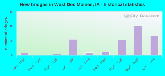
- New bridges - historical statistics
- 31930-1939
- 21950-1959
- 221960-1969
- 41970-1979
- 51980-1989
- 211990-1999
- 402000-2009
- 272010-2019
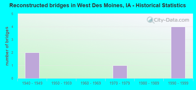
- Reconstructed bridges - Historical Statistics
- 21940-1949
- 01950-1959
- 01960-1969
- 11970-1979
- 01980-1989
- 41990-1999

- Bridge Condition - Deck
- 31.6%Very good
- 36.8%Good
- 24.6%Satisfactory
- 1.8%Fair
- 5.3%Poor
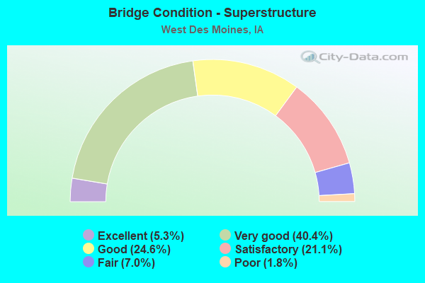
- Bridge Condition - Superstructure
- 5.3%Excellent
- 40.4%Very good
- 24.6%Good
- 21.1%Satisfactory
- 7.0%Fair
- 1.8%Poor

- Bridge Condition - Substructure
- 7.0%Excellent
- 36.8%Very good
- 28.1%Good
- 21.1%Satisfactory
- 3.5%Fair
- 3.5%Poor
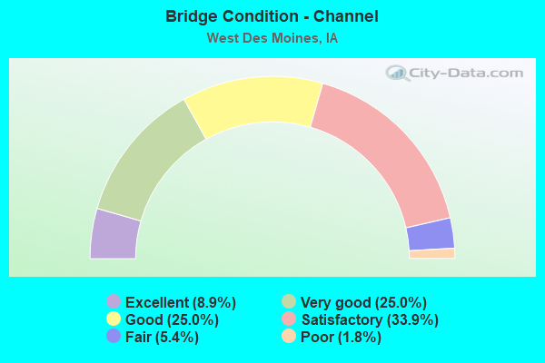
- Bridge Condition - Channel
- 8.9%Excellent
- 25.0%Very good
- 25.0%Good
- 33.9%Satisfactory
- 5.4%Fair
- 1.8%Poor
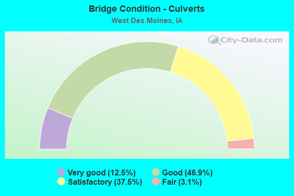
- Bridge Condition - Culverts
- 12.5%Very good
- 46.9%Good
- 37.5%Satisfactory
- 3.1%Fair
Find on map >> Show street view
Structure Number: 60858, Location: 3.1 MILES N OF JCT IA 28 (Lat: 41.522056, Lng: -93.737156), Route carried "on" structure: City street , Year Built: 2002, Status: Open, Structure Length: 7.75m (25.43ft), Average Daily Traffic: 30 (year 2008), Average Future Daily Traffic: 30 (year 2042), Design Load: HS 20, Features Intersected: IA 5, Facility Carried by Structure: 22ND STREET
Minimum Vertical Clearance: 30+ m (98+ ft), Kilometerpoint: 0.304, Lanes on structure: 2, Lanes under structure: 5, Owner: State Highway Agency, Approaching Roadway Width: 14.0m (45.9ft), Material/Design: Prestressed concrete, Design/Construction: Stringer/Multi-beam, Number Of Spans In Main Unit: 2, Length of Maximum Span: 41.7m (136.8ft), Curb or Sidewalk Widths: Left: 4.2m (13.8ft), Right: 0.0m, Curb-To-Curb Width: 12.0m (39.4ft), Out-to-Out Width: 17.5m (57.4ft)
Condition: Deck: Good, Superstructure: Good, Substructure: Good, Operating Rating: 72.3 metric tons, Method Used To Determine Operating Rating: Load Factor (LF), Inventory Rating: 27.8 metric tons, Method Used To Determine Inventory Rating: Load Factor (LF), Structural Evaluation: Equal to present minimum criteria, Deck Geometry: Superior to present desirable criteria, Underclear: Equal to present minimum criteria, Approach Roadway Alignment: Equal to present desirable criteria, Designated Inspection Frequency: Every 24 months, Inspection Date: Febuary 2022, Deck Structure Type: Concrete Cast-file-Place, Wearing Surface/Protective System: Wearing Surface: Monolithic Concrete, Deck Protection: Epoxy Coated Reinforcing
Find on map >> Show street view
Structure Number: 60866, Location: 1.6 MILES NW JUNCT IA 28 (Lat: 41.515475, Lng: -93.712878), Route carried "on" structure: State highway 5, Year Built: 2002, Status: Open, Structure Length: 5.64m (18.50ft), Average Daily Traffic: 13,650 (year 2020), Truck Traffic: 7%, Average Future Daily Traffic: 13,650 (year 2042), Design Load: HS 20+Mod, Features Intersected: 8TH STREET
Minimum Vertical Clearance: 30+ m (98+ ft), Kilometerpoint: 6.156, Lanes on structure: 2, Lanes under structure: 2, Owner: State Highway Agency, Approaching Roadway Width: 14.6m (47.9ft), Skew: 1 degrees, Material/Design: Prestressed concrete, Design/Construction: Stringer/Multi-beam, Number Of Spans In Main Unit: 3, Length of Maximum Span: 25.0m (82.0ft), Curb-To-Curb Width: 12.0m (39.4ft), Out-to-Out Width: 13.0m (42.7ft)
Condition: Deck: Very good, Superstructure: Very good, Substructure: Very good, Operating Rating: 72.3 metric tons, Method Used To Determine Operating Rating: Load Factor (LF), Inventory Rating: 43.4 metric tons, Method Used To Determine Inventory Rating: Load Factor (LF), Structural Evaluation: Equal to present desirable criteria, Deck Geometry: Better than present minimum criteria, Underclear: Superior to present desirable criteria, Approach Roadway Alignment: Equal to present desirable criteria, Designated Inspection Frequency: Every 24 months, Inspection Date: January 2022, Deck Structure Type: Concrete Cast-file-Place, Wearing Surface/Protective System: Wearing Surface: Monolithic Concrete, Deck Protection: Epoxy Coated Reinforcing
Find on map >> Show street view
Structure Number: 608665, Location: 1.6 MILES NW JCT IA 28 (Lat: 41.515269, Lng: -93.712053), Route carried "on" structure: State highway 5, Year Built: 2002, Status: Open, Structure Length: 5.64m (18.50ft), Average Daily Traffic: 13,650 (year 2020), Truck Traffic: 7%, Average Future Daily Traffic: 13,650 (year 2042), Design Load: HS 20+Mod, Features Intersected: 8TH STREET
Minimum Vertical Clearance: 30+ m (98+ ft), Kilometerpoint: 161.142, Lanes on structure: 2, Lanes under structure: 2, Base Highway Network: Yes, Owner: State Highway Agency, Approaching Roadway Width: 14.6m (47.9ft), Skew: 1 degrees, Material/Design: Prestressed concrete, Design/Construction: Stringer/Multi-beam, Number Of Spans In Main Unit: 3, Length of Maximum Span: 25.0m (82.0ft), Curb-To-Curb Width: 12.3m (40.4ft), Out-to-Out Width: 13.3m (43.6ft)
Condition: Deck: Very good, Superstructure: Very good, Substructure: Very good, Operating Rating: 44.4 metric tons, Method Used To Determine Operating Rating: Load Factor (LF), Inventory Rating: 32.7 metric tons, Method Used To Determine Inventory Rating: Load Factor (LF), Structural Evaluation: Equal to present desirable criteria, Deck Geometry: Better than present minimum criteria, Underclear: Equal to present minimum criteria, Approach Roadway Alignment: Equal to present desirable criteria, Designated Inspection Frequency: Every 24 months, Inspection Date: January 2022, Deck Structure Type: Concrete Cast-file-Place, Wearing Surface/Protective System: Wearing Surface: Monolithic Concrete, Deck Protection: Epoxy Coated Reinforcing
Find on map >> Show street view
Structure Number: 70006, Location: 1.7 mi. E of jct. SR R-22 (Lat: 41.568558, Lng: -93.853753), Route carried "on" structure: City street , Year Built: 2010, Status: Open, Structure Length: 11.27m (36.98ft), Average Daily Traffic: 3,200 (year 2018), Average Future Daily Traffic: 3,200 (year 2040), Design Load: HL 93, Features Intersected: I 80, Facility Carried by Structure: GRAND PRAIRIE PKWY
Minimum Vertical Clearance: 30+ m (98+ ft), Kilometerpoint: 1.299, Lanes on structure: 7, Lanes under structure: 6, Owner: State Highway Agency, Approaching Roadway Width: 8.5m (27.9ft), Skew: 3 degrees, Material/Design: Prestressed concrete, Design/Construction: Stringer/Multi-beam, Number Of Spans In Main Unit: 4, Length of Maximum Span: 41.8m (137.1ft), Curb-To-Curb Width: 33.5m (109.9ft), Out-to-Out Width: 34.5m (113.2ft)
Condition: Deck: Good, Superstructure: Very good, Substructure: Good, Channel: Excellent, Operating Rating: 42.1 metric tons, Method Used To Determine Operating Rating: Assigned ratings based on Load and Resistance Factor Design (LRFD) reported by rating factor (RF) using HL93 loadings, Inventory Rating: 32.4 metric tons, Method Used To Determine Inventory Rating: Assigned ratings based on Load and Resistance Factor Design (LRFD) reported by rating factor (RF) using HL93 loadings, Structural Evaluation: Better than present minimum criteria, Deck Geometry: Superior to present desirable criteria, Underclear: Somewhat better than minimum adequacy, Approach Roadway Alignment: Equal to present desirable criteria, Designated Inspection Frequency: Every 24 months, Inspection Date: October 2020, Deck Structure Type: Concrete Cast-file-Place, Wearing Surface/Protective System: Wearing Surface: Monolithic Concrete, Deck Protection: Epoxy Coated Reinforcing
Find on map >> Show street view
Structure Number: 70013, Location: 0.2 mi. S of Grand Ave. (Lat: 41.538847, Lng: -93.775872), Route carried "on" structure: Ramp Interstate 35, Year Built: 2013, Status: Open, Structure Length: 6.01m (19.72ft), Average Daily Traffic: 2,900 (year 2020), Truck Traffic: 9%, Average Future Daily Traffic: 2,900 (year 2040), Design Load: HL 93, Features Intersected: IAIS RR
Minimum Vertical Clearance: 30+ m (98+ ft), Kilometerpoint: 0.259, Lanes on structure: 1, Owner: State Highway Agency, Approaching Roadway Width: 9.8m (32.2ft), Skew: 4 degrees, Material/Design: Prestressed concrete, Design/Construction: Stringer/Multi-beam, Number Of Spans In Main Unit: 3, Length of Maximum Span: 32.6m (107.0ft), Curb-To-Curb Width: 7.9m (25.9ft), Out-to-Out Width: 8.9m (29.2ft)
Condition: Deck: Very good, Superstructure: Good, Substructure: Good, Operating Rating: 42.1 metric tons, Method Used To Determine Operating Rating: Assigned ratings based on Load and Resistance Factor Design (LRFD) reported by rating factor (RF) using HL93 loadings, Inventory Rating: 32.4 metric tons, Method Used To Determine Inventory Rating: Assigned ratings based on Load and Resistance Factor Design (LRFD) reported by rating factor (RF) using HL93 loadings, Structural Evaluation: Better than present minimum criteria, Deck Geometry: Equal to present desirable criteria, Underclear: Equal to present desirable criteria, Approach Roadway Alignment: Equal to present desirable criteria, Designated Inspection Frequency: Every 24 months, Inspection Date: April 2020, Deck Structure Type: Concrete Cast-file-Place, Wearing Surface/Protective System: Wearing Surface: Monolithic Concrete, Deck Protection: Epoxy Coated Reinforcing
Find on map >> Show street view
Structure Number: 700135, Location: 0.9 mi. N jct. IA 5 (Lat: 41.538181, Lng: -93.774244), Route carried "on" structure: Ramp Interstate 35, Year Built: 2014, Status: Open, Structure Length: 5.40m (17.72ft), Average Daily Traffic: 2,300 (year 2020), Truck Traffic: 11%, Average Future Daily Traffic: 2,300 (year 2041), Design Load: HL 93, Features Intersected: IAIS RR
Minimum Vertical Clearance: 30+ m (98+ ft), Kilometerpoint: 0.249, Lanes on structure: 2, Owner: State Highway Agency, Approaching Roadway Width: 14.6m (47.9ft), Skew: 1 degrees, Material/Design: Prestressed concrete, Design/Construction: Stringer/Multi-beam, Number Of Spans In Main Unit: 3, Length of Maximum Span: 22.6m (74.1ft), Curb-To-Curb Width: 11.4m (37.4ft), Out-to-Out Width: 12.4m (40.7ft)
Condition: Deck: Very good, Superstructure: Very good, Substructure: Very good, Operating Rating: 42.1 metric tons, Method Used To Determine Operating Rating: Assigned ratings based on Load and Resistance Factor Design (LRFD) reported by rating factor (RF) using HL93 loadings, Inventory Rating: 32.4 metric tons, Method Used To Determine Inventory Rating: Assigned ratings based on Load and Resistance Factor Design (LRFD) reported by rating factor (RF) using HL93 loadings, Structural Evaluation: Equal to present desirable criteria, Deck Geometry: Superior to present desirable criteria, Underclear: Superior to present desirable criteria, Approach Roadway Alignment: Equal to present desirable criteria, Designated Inspection Frequency: Every 24 months, Inspection Date: Febuary 2021, Deck Structure Type: Concrete Cast-file-Place, Wearing Surface/Protective System: Wearing Surface: Monolithic Concrete, Deck Protection: Epoxy Coated Reinforcing
Find on map >> Show street view
Structure Number: 12411, Location: 2.3 mi. S of Jct. I-235 (Lat: 41.559072, Lng: -93.776931), Route carried "under" structure: Interstate 35, Year Built: 2001, Structure Length: 0. m, Average Daily Traffic: 38,600 (year 2020), Truck Traffic: 17%, Features Intersected: I-35, Facility Carried by Structure: MILLS CIVIC PKW
Minimum Vertical Clearance: 30+ m (98+ ft), Kilometerpoint: 113.275, Lanes on structure: 6, Lanes under structure: 6, Material/Design: Prestressed concrete, Design/Construction: Stringer/Multi-beam, Length of Maximum Span: 27.7m (90.9ft)
Find on map >> Show street view
Structure Number: 12511, Location: 0.3 mi. E of W Jct. I-235 (Lat: 41.591744, Lng: -93.771158), Route carried "under" structure: Interstate 235, Year Built: 2000, Structure Length: 0. m, Average Daily Traffic: 50,900 (year 2020), Truck Traffic: 6%, Features Intersected: I-235, Facility Carried by Structure: 50TH ST-ST FARM
Minimum Vertical Clearance: 30+ m (98+ ft), Kilometerpoint: 1.223, Lanes on structure: 4, Lanes under structure: 7, Material/Design: Prestressed concrete, Design/Construction: Stringer/Multi-beam, Length of Maximum Span: 28.3m (92.8ft)
Find on map >> Show street view
Structure Number: 224, Location: 3.0 mi. W of W Jct. I-35 (Lat: 41.580089, Lng: -93.833014), Route carried "under" structure: Interstate 80, Year Built: 1966, Structure Length: 0. m, Average Daily Traffic: 41,900 (year 2020), Truck Traffic: 21%, Features Intersected: I-80, Facility Carried by Structure: FM F-64
Minimum Vertical Clearance: 30+ m (98+ ft), Kilometerpoint: 192.672, Lanes on structure: 2, Lanes under structure: 4, Material/Design: Steel continuous, Design/Construction: Stringer/Multi-beam, Length of Maximum Span: 22.6m (74.1ft)
Find on map >> Show street view
Structure Number: 41181, Location: At jct. of Grand Ave. (Lat: 41.540786, Lng: -93.775092), Route carried "under" structure: City street , Year Built: 2014, Structure Length: 0. m, Average Daily Traffic: 1,620 (year 2016), Features Intersected: GRAND AVE, Facility Carried by Structure: I 35 NB
Minimum Vertical Clearance: 30+ m (98+ ft), Kilometerpoint: 4.508, Lanes on structure: 3, Lanes under structure: 5, Material/Design: Prestressed concrete, Design/Construction: Stringer/Multi-beam, Length of Maximum Span: 41.5m (136.2ft)
Find on map >> Show street view
Structure Number: 41191, Location: At jct. of Grand Ave. (Lat: 41.541556, Lng: -93.775347), Route carried "under" structure: City street , Year Built: 2013, Structure Length: 0. m, Average Daily Traffic: 1,620 (year 2016), Features Intersected: GRAND AVE, Facility Carried by Structure: I 35 SB
Minimum Vertical Clearance: 30+ m (98+ ft), Kilometerpoint: 4.482, Lanes on structure: 3, Lanes under structure: 5, Material/Design: Prestressed concrete, Design/Construction: Stringer/Multi-beam, Length of Maximum Span: 41.5m (136.2ft)
Find on map >> Show street view
Structure Number: 41211, Location: 1.2 MI. S OF S JCT. I-80 (Lat: 41.574175, Lng: -93.777089), Route carried "under" structure: City street , Year Built: 2014, Structure Length: 0. m, Average Daily Traffic: 6,800 (year 2016), Features Intersected: RR, EP TRUE, CREEK, Facility Carried by Structure: I 35 NB
Minimum Vertical Clearance: 30+ m (98+ ft), Kilometerpoint: 4.408, Lanes on structure: 4, Lanes under structure: 4, Material/Design: Prestressed concrete, Design/Construction: Stringer/Multi-beam, Length of Maximum Span: 41.8m (137.1ft)
Find on map >> Show street view
Structure Number: 41221, Location: 1.2 MI. S OF S JCT. I-80 (Lat: 41.575439, Lng: -93.777281), Route carried "under" structure: City street , Year Built: 2013, Structure Length: 0. m, Average Daily Traffic: 6,800 (year 2016), Features Intersected: RR, EP TRUE, CREEK, Facility Carried by Structure: I 35 SB
Minimum Vertical Clearance: 30+ m (98+ ft), Kilometerpoint: 4.377, Lanes on structure: 4, Lanes under structure: 4, Material/Design: Prestressed concrete, Design/Construction: Stringer/Multi-beam, Length of Maximum Span: 41.8m (137.1ft)
Find on map >> Show street view
Structure Number: 41231, Location: 0.5 MILE S OF S JCT I-80 (Lat: 41.584506, Lng: -93.778036), Route carried "under" structure: Interstate 35, Year Built: 1991, Structure Length: 0. m, Average Daily Traffic: 65,500 (year 2020), Truck Traffic: 12%, Features Intersected: I-35, Facility Carried by Structure: ASHWORTH RD
Minimum Vertical Clearance: 30+ m (98+ ft), Kilometerpoint: 116.113, Lanes on structure: 4, Lanes under structure: 8, Material/Design: Prestressed concrete, Design/Construction: Stringer/Multi-beam, Length of Maximum Span: 27.7m (90.9ft)
Find on map >> Show street view
Structure Number: 41901, Location: 0.5 Mi. W of W Jct. I-35 (Lat: 41.591775, Lng: -93.790583), Route carried "under" structure: Interstate 80, Year Built: 1999, Structure Length: 0. m, Average Daily Traffic: 67,700 (year 2020), Truck Traffic: 14%, Features Intersected: I-80, Facility Carried by Structure: 60TH ST
Minimum Vertical Clearance: 30+ m (98+ ft), Kilometerpoint: 196.559, Lanes on structure: 5, Lanes under structure: 6, Material/Design: Prestressed concrete, Design/Construction: Stringer/Multi-beam, Length of Maximum Span: 40.2m (131.9ft)
Find on map >> Show street view
Structure Number: 4191, Location: AT WEST JCT I-35 & I-80 (Lat: 41.592100, Lng: -93.777767), Route carried "under" structure: Interstate 35, Year Built: 1966, Structure Length: 0. m, Average Daily Traffic: 26,450 (year 2020), Truck Traffic: 13%, Features Intersected: I 35 WEST JCT
Minimum Vertical Clearance: 30+ m (98+ ft), Kilometerpoint: 116.959, Lanes on structure: 3, Lanes under structure: 8, Material/Design: Prestressed concrete, Design/Construction: Stringer/Multi-beam, Length of Maximum Span: 24.7m (81.0ft)
Find on map >> Show street view
Structure Number: 4192, Location: AT WEST JUNCTION I-35-80 (Lat: 41.592306, Lng: -93.776814), Route carried "under" structure: Interstate 35, Year Built: 1966, Structure Length: 0. m, Average Daily Traffic: 27,950 (year 2020), Truck Traffic: 14%, Features Intersected: I-35
Minimum Vertical Clearance: 30+ m (98+ ft), Kilometerpoint: 116.988, Lanes on structure: 3, Lanes under structure: 8, Material/Design: Prestressed concrete, Design/Construction: Stringer/Multi-beam, Length of Maximum Span: 25.6m (84.0ft)
Find on map >> Show street view
Structure Number: 4215, Location: AT W JCT. I-35 (Lat: 41.589508, Lng: -93.777864), Route carried "under" structure: Interstate 35, Year Built: 1966, Structure Length: 0. m, Average Daily Traffic: 26,450 (year 2020), Truck Traffic: 13%, Features Intersected: I-35, Facility Carried by Structure: I 80 EB
Minimum Vertical Clearance: 30+ m (98+ ft), Kilometerpoint: 116.671, Lanes on structure: 2, Lanes under structure: 6, Material/Design: Steel continuous, Design/Construction: Stringer/Multi-beam, Length of Maximum Span: 20.4m (66.9ft)
Find on map >> Show street view
Structure Number: 4216, Location: 0.2 MI. E OF W JCT. I-80 (Lat: 41.591939, Lng: -93.773267), Route carried "under" structure: Interstate 235, Year Built: 1966, Structure Length: 0. m, Average Daily Traffic: 50,900 (year 2020), Truck Traffic: 6%, Features Intersected: I 235, Facility Carried by Structure: I 80 EB
Minimum Vertical Clearance: 30+ m (98+ ft), Kilometerpoint: 1.059, Lanes on structure: 2, Lanes under structure: 5, Material/Design: Steel continuous, Design/Construction: Stringer/Multi-beam, Length of Maximum Span: 19.2m (63.0ft)
Find on map >> Show street view
Structure Number: 42171, Location: 0.8 mi. E of W Jct. I-35 (Lat: 41.592025, Lng: -93.761503), Route carried "under" structure: Interstate 235, Year Built: 2001, Structure Length: 0. m, Average Daily Traffic: 68,500 (year 2020), Truck Traffic: 8%, Features Intersected: I-235, Facility Carried by Structure: 42ND ST WDSM
Minimum Vertical Clearance: 30+ m (98+ ft), Kilometerpoint: 2.039, Lanes on structure: 2, Lanes under structure: 8, Material/Design: Prestressed concrete, Design/Construction: Stringer/Multi-beam, Length of Maximum Span: 38.4m (126.0ft)
Find on map >> Show street view
Structure Number: 42181, Location: 1.3 mi. E of W Jct. 35/80 (Lat: 41.591939, Lng: -93.751747), Route carried "under" structure: Interstate 235, Year Built: 2003, Structure Length: 0. m, Average Daily Traffic: 76,500 (year 2020), Truck Traffic: 7%, Features Intersected: I 235, Facility Carried by Structure: VALLEY WEST DR
Minimum Vertical Clearance: 30+ m (98+ ft), Kilometerpoint: 2.834, Lanes on structure: 5, Lanes under structure: 7, Material/Design: Prestressed concrete, Design/Construction: Stringer/Multi-beam, Length of Maximum Span: 39.6m (129.9ft)
Find on map >> Show street view
Structure Number: 42191, Location: 1.8 mi. E of W Jct. 35/80 (Lat: 41.592006, Lng: -93.742161), Route carried "under" structure: Interstate 235, Year Built: 2005, Structure Length: 0. m, Average Daily Traffic: 88,000 (year 2020), Truck Traffic: 6%, Features Intersected: I-235, Facility Carried by Structure: 28TH ST
Minimum Vertical Clearance: 30+ m (98+ ft), Kilometerpoint: 3.653, Lanes on structure: 2, Lanes under structure: 8, Material/Design: Prestressed concrete, Design/Construction: Stringer/Multi-beam, Length of Maximum Span: 41.5m (136.2ft)
Find on map >> Show street view
Structure Number: 422, Location: 2.1 MI E OF W JCT I-35/80 (Lat: 41.592744, Lng: -93.736431), Route carried "under" structure: City street , Year Built: 1968, Structure Length: 0. m, Average Daily Traffic: 3,500 (year 2016), Features Intersected: 22ND ST, Facility Carried by Structure: EB I-235
Minimum Vertical Clearance: 30+ m (98+ ft), Kilometerpoint: 1.355, Lanes on structure: 3, Lanes under structure: 4, Material/Design: Prestressed concrete, Design/Construction: Stringer/Multi-beam, Length of Maximum Span: 22.3m (73.2ft)
Find on map >> Show street view
Structure Number: 4221, Location: 2.1 MI E OF W JCT I-35/80 (Lat: 41.592972, Lng: -93.735789), Route carried "under" structure: City street , Year Built: 1968, Structure Length: 0. m, Average Daily Traffic: 3,500 (year 2016), Features Intersected: 22ND ST, Facility Carried by Structure: WB I-235
Minimum Vertical Clearance: 30+ m (98+ ft), Kilometerpoint: 1.373, Lanes on structure: 3, Lanes under structure: 4, Material/Design: Prestressed concrete, Design/Construction: Stringer/Multi-beam, Length of Maximum Span: 22.3m (73.2ft)
Find on map >> Show street view
Structure Number: 4222, Location: 1.3 mi. W of Jct. IA #28 (Lat: 41.593286, Lng: -93.727597), Route carried "under" structure: City street , Year Built: 1967, Structure Length: 0. m, Average Daily Traffic: 900 (year 1996), Features Intersected: 17TH ST, Facility Carried by Structure: EB I-235
Minimum Vertical Clearance: 30+ m (98+ ft), Kilometerpoint: 1.188, Lanes on structure: 4, Lanes under structure: 2, Material/Design: Prestressed concrete, Design/Construction: Stringer/Multi-beam, Length of Maximum Span: 17.4m (57.1ft)
Find on map >> Show street view
Structure Number: 4223, Location: 1.3 mi. W of Jct. IA #28 (Lat: 41.593458, Lng: -93.727061), Route carried "under" structure: City street , Year Built: 1967, Structure Length: 0. m, Average Daily Traffic: 900 (year 1996), Features Intersected: 17TH ST, Facility Carried by Structure: WB I-235
Minimum Vertical Clearance: 30+ m (98+ ft), Kilometerpoint: 1.209, Lanes on structure: 4, Lanes under structure: 2, Material/Design: Prestressed concrete, Design/Construction: Stringer/Multi-beam, Length of Maximum Span: 17.4m (57.1ft)
Find on map >> Show street view
Structure Number: 51461, Location: 1.5 mi. N of SR G14 (Lat: 41.504864, Lng: -93.781053), Route carried "under" structure: Interstate 35, Year Built: 2016, Structure Length: 0. m, Average Daily Traffic: 24,300 (year 2020), Truck Traffic: 26%, Features Intersected: I 35
Minimum Vertical Clearance: 30+ m (98+ ft), Kilometerpoint: 107.097, Lanes on structure: 2, Lanes under structure: 4, Material/Design: Prestressed concrete, Design/Construction: Stringer/Multi-beam, Length of Maximum Span: 40.5m (132.9ft)
Find on map >> Show street view
Structure Number: 50448, Location: 0.2 mi. E of I-235 (Lat: 41.595378, Lng: -93.778425), Route carried "under" structure: Interstate 35, Year Built: 1997, Structure Length: 0. m, Average Daily Traffic: 52,800 (year 2020), Truck Traffic: 14%, Features Intersected: I-80/I-35, Facility Carried by Structure: WESTOWN PARKWAY
Minimum Vertical Clearance: 30+ m (98+ ft), Kilometerpoint: 117.318, Lanes on structure: 4, Lanes under structure: 12, Material/Design: Prestressed concrete, Design/Construction: Stringer/Multi-beam, Length of Maximum Span: 44.2m (145.0ft)
Find on map >> Show street view
Structure Number: 50448, Location: 0.2 mi. E of I-235 (Lat: 41.595378, Lng: -93.778425), Route carried "under" structure: Ramp Interstate 80, Year Built: 1997, Structure Length: 0. m, Average Daily Traffic: 12,700 (year 2020), Truck Traffic: 27%, Features Intersected: I-80/I-35, Facility Carried by Structure: WESTOWN PARKWAY
Minimum Vertical Clearance: 30+ m (98+ ft), Kilometerpoint: 198.614, Lanes on structure: 4, Lanes under structure: 12, Material/Design: Prestressed concrete, Design/Construction: Stringer/Multi-beam, Length of Maximum Span: 44.2m (145.0ft)
Find on map >> Show street view
Structure Number: 50451, Location: 1.6 mi. W of W Jct. I-35 (Lat: 41.591311, Lng: -93.808939), Route carried "under" structure: Interstate 80, Year Built: 2001, Structure Length: 0. m, Average Daily Traffic: 37,700 (year 2020), Truck Traffic: 23%, Features Intersected: I-80, Facility Carried by Structure: JORDAN CREEK PKWY
Minimum Vertical Clearance: 30+ m (98+ ft), Kilometerpoint: 195.015, Lanes on structure: 6, Lanes under structure: 6, Material/Design: Prestressed concrete, Design/Construction: Stringer/Multi-beam, Length of Maximum Span: 32.6m (107.0ft)
Find on map >> Show street view
Structure Number: 605405, Location: 1.0 MILE E OF W JCT I-35 (Lat: 41.597469, Lng: -93.776103), Route carried "under" structure: Ramp Interstate 80, Year Built: 1984, Structure Length: 0. m, Average Daily Traffic: 21,200 (year 2020), Truck Traffic: 22%, Features Intersected: RAMP H, Facility Carried by Structure: NB RAMP TO UNIV
Minimum Vertical Clearance: 30+ m (98+ ft), Kilometerpoint: 198.905, Lanes on structure: 1, Lanes under structure: 2, Material/Design: Steel continuous, Design/Construction: Stringer/Multi-beam, Length of Maximum Span: 36.0m (118.1ft)
Find on map >> Show street view
Structure Number: 60753, Location: 1.6 mi. E of Jct. I-35 (Lat: 41.522458, Lng: -93.748994), Route carried "under" structure: State highway 5, Year Built: 2002, Structure Length: 0. m, Average Daily Traffic: 27,400 (year 2020), Truck Traffic: 7%, Features Intersected: IA 5
Minimum Vertical Clearance: 30+ m (98+ ft), Kilometerpoint: 164.480, Lanes on structure: 2, Lanes under structure: 4, Material/Design: Prestressed concrete, Design/Construction: Stringer/Multi-beam, Length of Maximum Span: 41.1m (134.8ft)
Find on map >> Show street view
Structure Number: 60809, Location: 0.2 mi. S of Jct. IA 5 (Lat: 41.519522, Lng: -93.775675), Route carried "under" structure: Interstate 35, Year Built: 2000, Structure Length: 0. m, Average Daily Traffic: 23,000 (year 2020), Truck Traffic: 26%, Features Intersected: I-35, Facility Carried by Structure: MAFFITT LAKE RD
Minimum Vertical Clearance: 30+ m (98+ ft), Kilometerpoint: 108.845, Lanes on structure: 2, Lanes under structure: 7, Material/Design: Prestressed concrete, Design/Construction: Stringer/Multi-beam, Length of Maximum Span: 43.6m (143.0ft)
Find on map >> Show street view
Structure Number: 60823, Location: Jct. of IA 5 (Lat: 41.525144, Lng: -93.771328), Route carried "under" structure: Interstate 35, Year Built: 2000, Structure Length: 0. m, Average Daily Traffic: 21,500 (year 2020), Truck Traffic: 27%, Features Intersected: I-35 & IA #5 RAMP C
Minimum Vertical Clearance: 30+ m (98+ ft), Kilometerpoint: 109.468, Lanes on structure: 1, Lanes under structure: 8, Material/Design: Prestressed concrete, Design/Construction: Stringer/Multi-beam, Length of Maximum Span: 43.0m (141.1ft)
Find on map >> Show street view
Structure Number: 60824, Location: At Jct. I-35 (Lat: 41.524406, Lng: -93.773475), Route carried "under" structure: Interstate 35, Year Built: 2002, Structure Length: 0. m, Average Daily Traffic: 21,500 (year 2020), Truck Traffic: 27%, Features Intersected: I-35, Facility Carried by Structure: IA 5 - RAMP C
Minimum Vertical Clearance: 30+ m (98+ ft), Kilometerpoint: 109.353, Lanes on structure: 2, Lanes under structure: 6, Material/Design: Prestressed concrete, Design/Construction: Stringer/Multi-beam, Length of Maximum Span: 43.0m (141.1ft)
Find on map >> Show street view
Structure Number: 608345, Location: 2.3 MILES N OF JCT IA 28 (Lat: 41.520661, Lng: -93.721514), Route carried "under" structure: State highway 5, Year Built: 2002, Structure Length: 0. m, Average Daily Traffic: 26,900 (year 2020), Truck Traffic: 7%, Features Intersected: IA 5, Facility Carried by Structure: SW CONNECTOR
Minimum Vertical Clearance: 30+ m (98+ ft), Kilometerpoint: 162.133, Lanes on structure: 4, Lanes under structure: 4, Material/Design: Prestressed concrete, Design/Construction: Stringer/Multi-beam, Length of Maximum Span: 41.1m (134.8ft)
Find on map >> Show street view
Structure Number: 608575, Location: 0.6 MILE S OF JUNCT I-35 (Lat: 41.522342, Lng: -93.760842), Route carried "under" structure: State highway 5, Year Built: 2002, Structure Length: 0. m, Average Daily Traffic: 29,600 (year 2020), Truck Traffic: 7%, Features Intersected: IA 5, Facility Carried by Structure: S 42ND STREET
Minimum Vertical Clearance: 30+ m (98+ ft), Kilometerpoint: 165.468, Lanes on structure: 2, Lanes under structure: 5, Material/Design: Prestressed concrete, Design/Construction: Stringer/Multi-beam, Length of Maximum Span: 40.1m (131.6ft)
Find on map >> Show street view
Structure Number: 60858, Location: 3.1 MILES N OF JCT IA 28 (Lat: 41.522056, Lng: -93.737156), Route carried "under" structure: State highway 5, Year Built: 2002, Structure Length: 0. m, Average Daily Traffic: 27,800 (year 2020), Truck Traffic: 7%, Features Intersected: IA 5, Facility Carried by Structure: 22ND STREET
Minimum Vertical Clearance: 30+ m (98+ ft), Kilometerpoint: 163.487, Lanes on structure: 2, Lanes under structure: 5, Material/Design: Prestressed concrete, Design/Construction: Stringer/Multi-beam, Length of Maximum Span: 41.7m (136.8ft)
Find on map >> Show street view
Structure Number: 60866, Location: 1.6 MILES NW JUNCT IA 28 (Lat: 41.515475, Lng: -93.712878), Route carried "under" structure: City street , Year Built: 2002, Structure Length: 0. m, Average Daily Traffic: 51 (year 2011), Features Intersected: 8TH STREET, Facility Carried by Structure: IA 5 SB
Minimum Vertical Clearance: 30+ m (98+ ft), Kilometerpoint: 1.122, Lanes on structure: 2, Lanes under structure: 2, Material/Design: Prestressed concrete, Design/Construction: Stringer/Multi-beam, Length of Maximum Span: 25.0m (82.0ft)
Find on map >> Show street view
Structure Number: 608665, Location: 1.6 MILES NW JCT IA 28 (Lat: 41.515269, Lng: -93.712053), Route carried "under" structure: City street , Year Built: 2002, Structure Length: 0. m, Average Daily Traffic: 51 (year 2011), Features Intersected: 8TH STREET, Facility Carried by Structure: IA 5 NB
Minimum Vertical Clearance: 30+ m (98+ ft), Kilometerpoint: 1.152, Lanes on structure: 2, Lanes under structure: 2, Material/Design: Prestressed concrete, Design/Construction: Stringer/Multi-beam, Length of Maximum Span: 25.0m (82.0ft)
Find on map >> Show street view
Structure Number: 70006, Location: 1.7 mi. E of jct. SR R-22 (Lat: 41.568558, Lng: -93.853753), Route carried "under" structure: Interstate 80, Year Built: 2010, Structure Length: 0. m, Average Daily Traffic: 33,800 (year 2020), Truck Traffic: 23%, Features Intersected: I 80, Facility Carried by Structure: GRAND PRAIRIE PKWY
Minimum Vertical Clearance: 30+ m (98+ ft), Kilometerpoint: 190.525, Lanes on structure: 7, Lanes under structure: 6, Material/Design: Prestressed concrete, Design/Construction: Stringer/Multi-beam, Length of Maximum Span: 41.8m (137.1ft)