Bridge Statistics for West Plains, Missouri (MO)
Condition, Traffic, Stress, Structural Evaluation, Project Costs
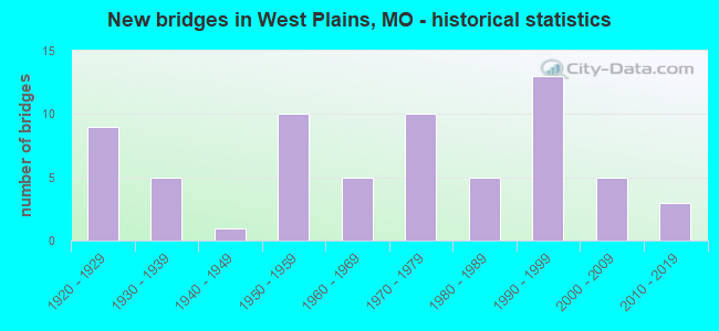
- New bridges - historical statistics
- 91920-1929
- 51930-1939
- 11940-1949
- 101950-1959
- 51960-1969
- 101970-1979
- 51980-1989
- 131990-1999
- 52000-2009
- 32010-2019
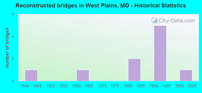
- Reconstructed bridges - Historical Statistics
- 11940-1949
- 01950-1959
- 11960-1969
- 01970-1979
- 21980-1989
- 51990-1999
- 12000-2009
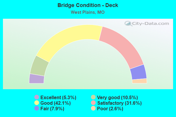
- Bridge Condition - Deck
- 5.3%Excellent
- 10.5%Very good
- 42.1%Good
- 31.6%Satisfactory
- 7.9%Fair
- 2.6%Poor
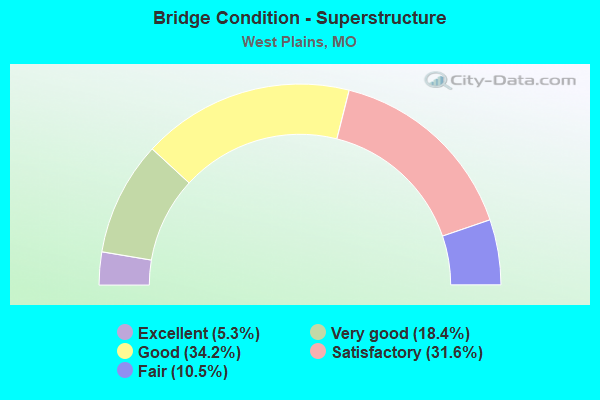
- Bridge Condition - Superstructure
- 5.3%Excellent
- 18.4%Very good
- 34.2%Good
- 31.6%Satisfactory
- 10.5%Fair
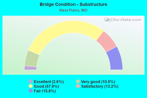
- Bridge Condition - Substructure
- 2.6%Excellent
- 10.5%Very good
- 57.9%Good
- 13.2%Satisfactory
- 15.8%Fair
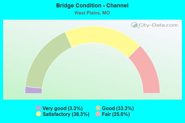
- Bridge Condition - Channel
- 3.3%Very good
- 33.3%Good
- 38.3%Satisfactory
- 25.0%Fair
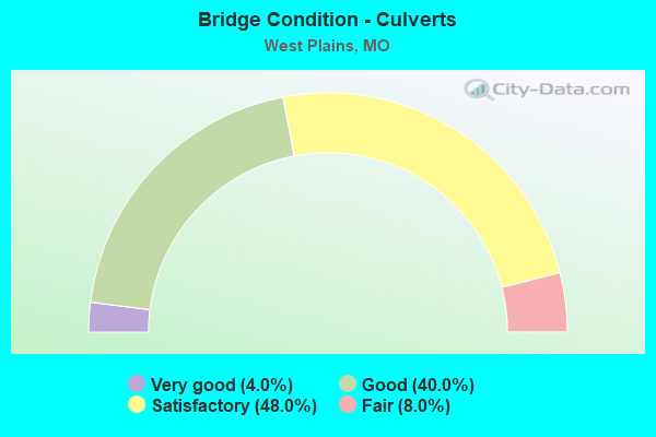
- Bridge Condition - Culverts
- 4.0%Very good
- 40.0%Good
- 48.0%Satisfactory
- 8.0%Fair
Find on map >> Show street view
Structure Number: 3483, Location: S 21 T 24 N R 8 W (Lat: 36.737689, Lng: -91.857456), Route carried "on" structure: City street , Year Built: 2013, Status: Open, Structure Length: 2.74m (8.99ft), Average Daily Traffic: 3,290 (year 2021), Truck Traffic: 10%, Average Future Daily Traffic: 4,771 (year 2041), Design Load: HS 20+Mod, Features Intersected: HOWELL CR, Facility Carried by Structure: THORNBROUGH ST
Minimum Vertical Clearance: 30+ m (98+ ft), Kilometerpoint: 0.000, Lanes on structure: 2, Owner: City or Municipal Highway Agency, Approaching Roadway Width: 11.3m (37.1ft), Skew: 4 degrees, Material/Design: Concrete, Design/Construction: Box Beam or Girders - Multiple, Number Of Spans In Main Unit: 2, Length of Maximum Span: 13.7m (44.9ft), Curb-To-Curb Width: 11.0m (36.1ft), Out-to-Out Width: 13.4m (44.0ft)
Condition: Deck: Good, Superstructure: Good, Substructure: Good, Channel: Satisfactory, Operating Rating: 63.0 metric tons, Method Used To Determine Operating Rating: Load Factor (LF), Inventory Rating: 37.8 metric tons, Method Used To Determine Inventory Rating: Load Factor (LF), Structural Evaluation: Better than present minimum criteria, Deck Geometry: Somewhat better than minimum adequacy, Waterway Adequacy: Somewhat better than minimum adequacy, Approach Roadway Alignment: Equal to present desirable criteria, Designated Inspection Frequency: Every 24 months, Inspection Date: November 2020, Deck Structure Type: Other, Wearing Surface/Protective System: Wearing Surface: Bituminous, Deck Protection: Epoxy Coated Reinforcing
Find on map >> Show street view
Structure Number: 3499, Location: S 34 T 24 N R 8 W (Lat: 36.703833, Lng: -91.826833), Route carried "on" structure: County highway 563, Year Built: 2015, Status: Open, Structure Length: 2.74m (8.99ft), Average Daily Traffic: 200 (year 2021), Truck Traffic: 10%, Average Future Daily Traffic: 260 (year 2041), Design Load: HS 20, Features Intersected: MUSTION CR, Facility Carried by Structure: CREAMY RD
Minimum Vertical Clearance: 30+ m (98+ ft), Kilometerpoint: 0.322, Lanes on structure: 2, Owner: County Highway Agency, Approaching Roadway Width: 7.3m (24.0ft), Material/Design: Prestressed concrete continuous, Design/Construction: Box Beam or Girders - Multiple, Number Of Spans In Main Unit: 2, Length of Maximum Span: 13.7m (44.9ft), Curb-To-Curb Width: 7.3m (24.0ft), Out-to-Out Width: 7.5m (24.6ft)
Condition: Deck: Excellent, Superstructure: Excellent, Substructure: Good, Channel: Satisfactory, Operating Rating: 55.8 metric tons, Method Used To Determine Operating Rating: Load Factor (LF), Inventory Rating: 33.3 metric tons, Method Used To Determine Inventory Rating: Load Factor (LF), Structural Evaluation: Better than present minimum criteria, Deck Geometry: Somewhat better than minimum adequacy, Waterway Adequacy: Better than present minimum criteria, Approach Roadway Alignment: Equal to present minimum criteria, Designated Inspection Frequency: Every 24 months, Inspection Date: November 2020, Deck Structure Type: Concrete Precast Panels, Wearing Surface/Protective System: Wearing Surface: Monolithic Concrete
Find on map >> Show street view
Structure Number: 4324, Location: S 3 T 25 N R 9 W (Lat: 36.873269, Lng: -91.914242), Route carried "on" structure: US 63, Year Built: 1997, Status: Open, Structure Length: 7.65m (25.10ft), Average Daily Traffic: 5,766 (year 2021), Truck Traffic: 22%, Average Future Daily Traffic: 10,955 (year 2041), Design Load: HS 20+Mod, Features Intersected: CRD 4490, BNSF RR
Minimum Vertical Clearance: 30+ m (98+ ft), Kilometerpoint: 62.454, Lanes on structure: 2, Lanes under structure: 2, Base Highway Network: Yes, Owner: State Highway Agency, Approaching Roadway Width: 12.5m (41.0ft), Skew: 2 degrees, Material/Design: Prestressed concrete continuous, Design/Construction: Stringer/Multi-beam, Number Of Spans In Main Unit: 4, Length of Maximum Span: 20.7m (67.9ft), Curb or Sidewalk Widths: Left: 0.4m (1.3ft), Right: 0.4m (1.3ft), Curb-To-Curb Width: 11.2m (36.7ft), Out-to-Out Width: 12.1m (39.7ft)
Condition: Deck: Good, Superstructure: Very good, Substructure: Very good, Operating Rating: 85.5 metric tons, Method Used To Determine Operating Rating: Load Factor (LF), Inventory Rating: 51.3 metric tons, Method Used To Determine Inventory Rating: Load Factor (LF), Structural Evaluation: Equal to present desirable criteria, Deck Geometry: Equal to present minimum criteria, Underclear: Superior to present desirable criteria, Approach Roadway Alignment: Equal to present desirable criteria, Designated Inspection Frequency: Every 24 months, Inspection Date: December 2020, Deck Structure Type: Concrete Cast-file-Place, Wearing Surface/Protective System: Wearing Surface: Monolithic Concrete
Find on map >> Show street view
Structure Number: 4325, Location: S 3 T 25 N R 9 W (Lat: 36.873539, Lng: -91.914381), Route carried "on" structure: US 63, Year Built: 1997, Status: Open, Structure Length: 7.65m (25.10ft), Average Daily Traffic: 6,497 (year 2021), Truck Traffic: 30%, Average Future Daily Traffic: 12,344 (year 2041), Design Load: HS 20+Mod, Features Intersected: CRD 4490, BNSF RR
Minimum Vertical Clearance: 30+ m (98+ ft), Kilometerpoint: 480.112, Lanes on structure: 2, Lanes under structure: 2, Base Highway Network: Yes, Owner: State Highway Agency, Approaching Roadway Width: 12.5m (41.0ft), Skew: 2 degrees, Material/Design: Prestressed concrete continuous, Design/Construction: Stringer/Multi-beam, Number Of Spans In Main Unit: 4, Length of Maximum Span: 20.7m (67.9ft), Curb or Sidewalk Widths: Left: 0.4m (1.3ft), Right: 0.4m (1.3ft), Curb-To-Curb Width: 11.2m (36.7ft), Out-to-Out Width: 12.1m (39.7ft)
Condition: Deck: Good, Superstructure: Very good, Substructure: Very good, Operating Rating: 85.5 metric tons, Method Used To Determine Operating Rating: Load Factor (LF), Inventory Rating: 51.3 metric tons, Method Used To Determine Inventory Rating: Load Factor (LF), Structural Evaluation: Equal to present desirable criteria, Deck Geometry: Equal to present minimum criteria, Underclear: Superior to present desirable criteria, Approach Roadway Alignment: Equal to present desirable criteria, Designated Inspection Frequency: Every 24 months, Inspection Date: December 2020, Deck Structure Type: Concrete Cast-file-Place, Wearing Surface/Protective System: Wearing Surface: Monolithic Concrete
Find on map >> Show street view
Structure Number: 4326, Location: S 17 T 24 N R 8 W (Lat: 36.753844, Lng: -91.873525), Route carried "on" structure: US 63, Year Built: 1995, Status: Open, Structure Length: 6.04m (19.82ft), Average Daily Traffic: 12,927 (year 2021), Truck Traffic: 21%, Average Future Daily Traffic: 24,561 (year 2041), Design Load: HS 20+Mod, Features Intersected: BU 63
Minimum Vertical Clearance: 30+ m (98+ ft), Kilometerpoint: 494.593, Lanes on structure: 4, Lanes under structure: 4, Base Highway Network: Yes, Owner: State Highway Agency, Approaching Roadway Width: 22.6m (74.1ft), Material/Design: Prestressed concrete continuous, Design/Construction: Stringer/Multi-beam, Number Of Spans In Main Unit: 3, Length of Maximum Span: 28.7m (94.2ft), Curb or Sidewalk Widths: Left: 0.2m (0.7ft), Right: 0.2m (0.7ft), Curb-To-Curb Width: 22.6m (74.1ft), Out-to-Out Width: 23.4m (76.8ft)
Condition: Deck: Satisfactory, Superstructure: Good, Substructure: Good, Inventory Rating: 54.9 metric tons, Method Used To Determine Inventory Rating: Load Factor (LF), Structural Evaluation: Better than present minimum criteria, Deck Geometry: Superior to present desirable criteria, Underclear: Equal to present minimum criteria, Approach Roadway Alignment: Equal to present desirable criteria, Designated Inspection Frequency: Every 24 months, Inspection Date: December 2020, Deck Structure Type: Concrete Cast-file-Place, Wearing Surface/Protective System: Wearing Surface: Monolithic Concrete, Deck Protection: Epoxy Coated Reinforcing
Find on map >> Show street view
Structure Number: 4337, Location: S 17 T 24 N R 8 W (Lat: 36.753753, Lng: -91.873297), Route carried "on" structure: Business State highway 63, Year Built: 1995, Status: Open, Structure Length: 1.41m (4.63ft), Average Daily Traffic: 4,304 (year 2021), Truck Traffic: 3%, Average Future Daily Traffic: 6,886 (year 2041), Design Load: HS 20, Features Intersected: N BR OF HOWELL CR
Minimum Vertical Clearance: 30+ m (98+ ft), Kilometerpoint: 0.111, Lanes on structure: 1, Owner: State Highway Agency, Approaching Roadway Width: 9.1m (29.9ft), Material/Design: Concrete continuous, Design/Construction: Culvert, Number Of Spans In Main Unit: 3, Length of Maximum Span: 4.6m (15.1ft)
Condition: Channel: Satisfactory, Culverts: Good, Operating Rating: 87.3 metric tons, Method Used To Determine Operating Rating: Field evaluation and documented engineering judgment, Inventory Rating: 52.2 metric tons, Method Used To Determine Inventory Rating: Field evaluation and documented engineering judgment, Structural Evaluation: Better than present minimum criteria, Waterway Adequacy: Equal to present desirable criteria, Approach Roadway Alignment: Equal to present desirable criteria, Designated Inspection Frequency: Every 24 months, Inspection Date: October 2020
Find on map >> Show street view
Structure Number: 4338, Location: S 17 T 24 N R 8 W (Lat: 36.752542, Lng: -91.873975), Route carried "on" structure: US 63, Year Built: 1995, Status: Open, Structure Length: 1.43m (4.69ft), Average Daily Traffic: 14,078 (year 2021), Truck Traffic: 21%, Average Future Daily Traffic: 26,748 (year 2041), Design Load: HS 20, Features Intersected: N BR OF HOWELL CR
Minimum Vertical Clearance: 30+ m (98+ ft), Kilometerpoint: 494.791, Lanes on structure: 2, Base Highway Network: Yes, Owner: State Highway Agency, Approaching Roadway Width: 22.6m (74.1ft), Skew: 1 degrees, Material/Design: Concrete continuous, Design/Construction: Culvert, Number Of Spans In Main Unit: 3, Length of Maximum Span: 4.6m (15.1ft)
Condition: Channel: Good, Culverts: Good, Operating Rating: 87.3 metric tons, Method Used To Determine Operating Rating: Field evaluation and documented engineering judgment, Inventory Rating: 52.2 metric tons, Method Used To Determine Inventory Rating: Field evaluation and documented engineering judgment, Structural Evaluation: Better than present minimum criteria, Waterway Adequacy: Equal to present desirable criteria, Approach Roadway Alignment: Equal to present desirable criteria, Designated Inspection Frequency: Every 24 months, Inspection Date: October 2020
Find on map >> Show street view
Structure Number: 447, Location: S 17 T 24 N R 8 W (Lat: 36.752411, Lng: -91.872464), Route carried "on" structure: Business State highway 63, Year Built: 1921, Year Reconstructed: 1990, Status: Open, Structure Length: 1.21m (3.97ft), Average Daily Traffic: 9,156 (year 2021), Truck Traffic: 3%, Average Future Daily Traffic: 14,650 (year 2041), Design Load: HS 20, Features Intersected: BR HOWELL CR
Minimum Vertical Clearance: 30+ m (98+ ft), Kilometerpoint: 0.343, Lanes on structure: 4, Owner: State Highway Agency, Approaching Roadway Width: 20.7m (67.9ft), Material/Design: Concrete continuous, Design/Construction: Culvert, Number Of Spans In Main Unit: 3, Length of Maximum Span: 4.2m (13.8ft)
Condition: Channel: Satisfactory, Culverts: Satisfactory, Operating Rating: 56.7 metric tons, Method Used To Determine Operating Rating: Load Factor (LF), Inventory Rating: 34.2 metric tons, Method Used To Determine Inventory Rating: Load Factor (LF), Structural Evaluation: Equal to present minimum criteria, Waterway Adequacy: Equal to present desirable criteria, Approach Roadway Alignment: Equal to present desirable criteria, Designated Inspection Frequency: Every 24 months, Inspection Date: October 2020
Find on map >> Show street view
Structure Number: 4534, Location: S 6 T 24 N R 8 W (Lat: 36.780828, Lng: -91.890281), Route carried "on" structure: US 63, Year Built: 1921, Year Reconstructed: 1994, Status: Open, Structure Length: 1.34m (4.40ft), Average Daily Traffic: 15,670 (year 2021), Truck Traffic: 30%, Average Future Daily Traffic: 25,072 (year 2041), Design Load: H 15, Features Intersected: GALLOWAY CR
Minimum Vertical Clearance: 30+ m (98+ ft), Kilometerpoint: 491.139, Lanes on structure: 4, Base Highway Network: Yes, Owner: State Highway Agency, Approaching Roadway Width: 26.8m (87.9ft), Skew: 4 degrees, Material/Design: Concrete continuous, Design/Construction: Culvert, Number Of Spans In Main Unit: 3, Length of Maximum Span: 3.0m (9.8ft)
Condition: Channel: Good, Culverts: Satisfactory, Inventory Rating: 62.1 metric tons, Method Used To Determine Inventory Rating: Load Factor (LF), Structural Evaluation: Equal to present minimum criteria, Waterway Adequacy: Equal to present desirable criteria, Approach Roadway Alignment: Equal to present desirable criteria, Designated Inspection Frequency: Every 24 months, Inspection Date: October 2020
Find on map >> Show street view
Structure Number: 4535, Location: S 1 T 23 N R 8 W (Lat: 36.686731, Lng: -91.790475), Route carried "on" structure: US 63, Year Built: 1921, Year Reconstructed: 1952, Status: Open, Structure Length: 0.76m (2.49ft), Average Daily Traffic: 7,489 (year 2021), Truck Traffic: 22%, Average Future Daily Traffic: 14,229 (year 2041), Design Load: H 15, Features Intersected: CHAPIN CR
Minimum Vertical Clearance: 30+ m (98+ ft), Kilometerpoint: 507.514, Lanes on structure: 2, Base Highway Network: Yes, Owner: State Highway Agency, Approaching Roadway Width: 13.4m (44.0ft), Material/Design: Concrete continuous, Design/Construction: Culvert, Number Of Spans In Main Unit: 2, Length of Maximum Span: 3.7m (12.1ft)
Condition: Channel: Good, Culverts: Good, Operating Rating: 63.9 metric tons, Method Used To Determine Operating Rating: Load Factor (LF), Inventory Rating: 37.8 metric tons, Method Used To Determine Inventory Rating: Load Factor (LF), Structural Evaluation: Better than present minimum criteria, Waterway Adequacy: Equal to present desirable criteria, Approach Roadway Alignment: Equal to present desirable criteria, Designated Inspection Frequency: Every 24 months, Inspection Date: October 2020
Find on map >> Show street view
Structure Number: 454, Location: S 6 T 23 N R 8 W (Lat: 36.685117, Lng: -91.788219), Route carried "on" structure: US 63, Year Built: 1952, Status: Open, Structure Length: 0.98m (3.22ft), Average Daily Traffic: 7,489 (year 2021), Truck Traffic: 22%, Average Future Daily Traffic: 14,229 (year 2041), Design Load: H 15, Features Intersected: BR CHAPIN BR
Minimum Vertical Clearance: 30+ m (98+ ft), Kilometerpoint: 507.778, Lanes on structure: 2, Base Highway Network: Yes, Owner: State Highway Agency, Approaching Roadway Width: 13.4m (44.0ft), Skew: 1 degrees, Material/Design: Concrete continuous, Design/Construction: Culvert, Number Of Spans In Main Unit: 3, Length of Maximum Span: 3.0m (9.8ft)
Condition: Channel: Satisfactory, Culverts: Good, Operating Rating: 65.7 metric tons, Method Used To Determine Operating Rating: Load Factor (LF), Inventory Rating: 39.6 metric tons, Method Used To Determine Inventory Rating: Load Factor (LF), Structural Evaluation: Better than present minimum criteria, Waterway Adequacy: Equal to present desirable criteria, Approach Roadway Alignment: Equal to present desirable criteria, Designated Inspection Frequency: Every 24 months, Inspection Date: October 2020
Find on map >> Show street view
Structure Number: 5816, Location: S 20 T 24 N R 8 W (Lat: 36.740547, Lng: -91.870914), Route carried "on" structure: Business State highway 63, Year Built: 1981, Status: Open, Structure Length: 1.00m (3.28ft), Average Daily Traffic: 13,122 (year 2021), Truck Traffic: 3%, Average Future Daily Traffic: 20,995 (year 2041), Design Load: HS 20, Features Intersected: N BR HOWELL VALLEY
Minimum Vertical Clearance: 30+ m (98+ ft), Kilometerpoint: 1.666, Lanes on structure: 4, Owner: State Highway Agency, Approaching Roadway Width: 21.9m (71.9ft), Skew: 4 degrees, Material/Design: Concrete continuous, Design/Construction: Culvert, Number Of Spans In Main Unit: 2, Length of Maximum Span: 3.7m (12.1ft)
Condition: Channel: Fair, Culverts: Satisfactory, Operating Rating: 81.9 metric tons, Method Used To Determine Operating Rating: Load Factor (LF), Inventory Rating: 48.6 metric tons, Method Used To Determine Inventory Rating: Load Factor (LF), Structural Evaluation: Equal to present minimum criteria, Waterway Adequacy: Equal to present desirable criteria, Approach Roadway Alignment: Equal to present desirable criteria, Designated Inspection Frequency: Every 24 months, Inspection Date: October 2020
Find on map >> Show street view
Structure Number: 5817, Location: S 20 T 24 N R 8 W (Lat: 36.738925, Lng: -91.869192), Route carried "on" structure: Business State highway 63, Year Built: 1981, Status: Open, Structure Length: 0.76m (2.49ft), Average Daily Traffic: 13,122 (year 2021), Truck Traffic: 3%, Average Future Daily Traffic: 20,995 (year 2041), Design Load: HS 20, Features Intersected: S BR HOWELL VALLEY
Minimum Vertical Clearance: 30+ m (98+ ft), Kilometerpoint: 1.902, Lanes on structure: 4, Owner: State Highway Agency, Approaching Roadway Width: 21.9m (71.9ft), Skew: 10 degrees, Material/Design: Concrete continuous, Design/Construction: Culvert, Number Of Spans In Main Unit: 2, Length of Maximum Span: 3.7m (12.1ft)
Condition: Channel: Satisfactory, Culverts: Satisfactory, Operating Rating: 95.4 metric tons, Method Used To Determine Operating Rating: Load Factor (LF), Inventory Rating: 57.6 metric tons, Method Used To Determine Inventory Rating: Load Factor (LF), Structural Evaluation: Equal to present minimum criteria, Waterway Adequacy: Equal to present desirable criteria, Approach Roadway Alignment: Equal to present desirable criteria, Designated Inspection Frequency: Every 24 months, Inspection Date: October 2020
Find on map >> Show street view
Structure Number: 617, Location: S 17 T 24 N R 8 W (Lat: 36.743503, Lng: -91.877089), Route carried "on" structure: US 63, Year Built: 1962, Year Reconstructed: 2004, Status: Open, Structure Length: 0.78m (2.56ft), Average Daily Traffic: 14,078 (year 2021), Truck Traffic: 21%, Average Future Daily Traffic: 26,748 (year 2041), Design Load: H 20, Features Intersected: HOWELL CR
Minimum Vertical Clearance: 30+ m (98+ ft), Kilometerpoint: 495.829, Lanes on structure: 5, Base Highway Network: Yes, Owner: State Highway Agency, Approaching Roadway Width: 38.1m (125.0ft), Skew: 1 degrees, Material/Design: Concrete continuous, Design/Construction: Culvert, Number Of Spans In Main Unit: 2, Length of Maximum Span: 3.7m (12.1ft)
Condition: Channel: Good, Culverts: Satisfactory, Operating Rating: 72.0 metric tons, Method Used To Determine Operating Rating: Field evaluation and documented engineering judgment, Inventory Rating: 43.2 metric tons, Method Used To Determine Inventory Rating: Field evaluation and documented engineering judgment, Structural Evaluation: Equal to present minimum criteria, Waterway Adequacy: Equal to present desirable criteria, Approach Roadway Alignment: Equal to present desirable criteria, Designated Inspection Frequency: Every 24 months, Inspection Date: October 2020
Find on map >> Show street view
Structure Number: 618, Location: S 19 T 24 N R 8 W (Lat: 36.730964, Lng: -91.877397), Route carried "on" structure: US 63, Year Built: 1962, Year Reconstructed: 2004, Status: Open, Structure Length: 1.12m (3.67ft), Average Daily Traffic: 10,707 (year 2021), Truck Traffic: 18%, Average Future Daily Traffic: 20,343 (year 2041), Design Load: H 20, Features Intersected: S BR HOWELL CR
Minimum Vertical Clearance: 30+ m (98+ ft), Kilometerpoint: 497.219, Lanes on structure: 5, Base Highway Network: Yes, Owner: State Highway Agency, Approaching Roadway Width: 38.4m (126.0ft), Skew: 2 degrees, Material/Design: Concrete continuous, Design/Construction: Culvert, Number Of Spans In Main Unit: 3, Length of Maximum Span: 3.4m (11.2ft)
Condition: Channel: Good, Culverts: Satisfactory, Operating Rating: 77.4 metric tons, Method Used To Determine Operating Rating: Load Factor (LF), Inventory Rating: 46.8 metric tons, Method Used To Determine Inventory Rating: Load Factor (LF), Structural Evaluation: Equal to present minimum criteria, Waterway Adequacy: Equal to present desirable criteria, Approach Roadway Alignment: Equal to present desirable criteria, Designated Inspection Frequency: Every 24 months, Inspection Date: October 2020
Find on map >> Show street view
Structure Number: 6249, Location: S 33 T 24 N R 8 W (Lat: 36.705864, Lng: -91.851039), Route carried "on" structure: State highway 17, Year Built: 1950, Status: Open, Structure Length: 0.99m (3.25ft), Average Daily Traffic: 2,778 (year 2021), Truck Traffic: 7%, Average Future Daily Traffic: 4,167 (year 2041), Design Load: H 15, Features Intersected: BR MUSTION BR
Minimum Vertical Clearance: 30+ m (98+ ft), Kilometerpoint: 273.148, Lanes on structure: 2, Owner: State Highway Agency, Approaching Roadway Width: 7.3m (24.0ft), Skew: 4 degrees, Material/Design: Concrete continuous, Design/Construction: Culvert, Number Of Spans In Main Unit: 2, Length of Maximum Span: 3.7m (12.1ft), Curb-To-Curb Width: 8.2m (26.9ft), Out-to-Out Width: 8.8m (28.9ft)
Condition: Channel: Satisfactory, Culverts: Good, Operating Rating: 56.7 metric tons, Method Used To Determine Operating Rating: Load Factor (LF), Inventory Rating: 34.2 metric tons, Method Used To Determine Inventory Rating: Load Factor (LF), Structural Evaluation: Better than present minimum criteria, Deck Geometry: High priority of corrective action, Waterway Adequacy: Equal to present desirable criteria, Approach Roadway Alignment: Equal to present minimum criteria, Length Of Structure Improvement: 0.17m (0.56ft), Designated Inspection Frequency: Every 24 months, Inspection Date: October 2020, Bridge Improvement Cost: $170,000, Roadway Improvement Cost: $17,000, Total Project Cost: $255,000 ( Estimate for 2022)
Find on map >> Show street view
Structure Number: 625, Location: S 33 T 24 N R 8 W (Lat: 36.708814, Lng: -91.850997), Route carried "on" structure: State highway 17, Year Built: 1950, Status: Open, Structure Length: 1.16m (3.81ft), Average Daily Traffic: 2,778 (year 2021), Truck Traffic: 7%, Average Future Daily Traffic: 4,167 (year 2041), Design Load: H 15, Features Intersected: MUSTION BR
Minimum Vertical Clearance: 30+ m (98+ ft), Kilometerpoint: 272.820, Lanes on structure: 2, Owner: State Highway Agency, Approaching Roadway Width: 7.3m (24.0ft), Material/Design: Concrete continuous, Design/Construction: Culvert, Number Of Spans In Main Unit: 3, Length of Maximum Span: 3.7m (12.1ft), Curb-To-Curb Width: 8.2m (26.9ft), Out-to-Out Width: 8.8m (28.9ft)
Condition: Channel: Satisfactory, Culverts: Fair, Operating Rating: 79.2 metric tons, Method Used To Determine Operating Rating: Load Factor (LF), Inventory Rating: 46.8 metric tons, Method Used To Determine Inventory Rating: Load Factor (LF), Structural Evaluation: Somewhat better than minimum adequacy, Deck Geometry: High priority of corrective action, Waterway Adequacy: Equal to present desirable criteria, Approach Roadway Alignment: Equal to present minimum criteria, Length Of Structure Improvement: 0.18m (0.59ft), Designated Inspection Frequency: Every 24 months, Inspection Date: October 2020, Bridge Improvement Cost: $170,000, Roadway Improvement Cost: $17,000, Total Project Cost: $255,000 ( Estimate for 2022)
Find on map >> Show street view
Structure Number: 6662, Location: S 1 T 23 N R 8 W (Lat: 36.693578, Lng: -91.800078), Route carried "on" structure: US 63, Year Built: 1952, Status: Open, Structure Length: 0.91m (2.99ft), Average Daily Traffic: 8,284 (year 2021), Truck Traffic: 20%, Average Future Daily Traffic: 15,740 (year 2041), Design Load: H 15, Features Intersected: BR HOWELL CR
Minimum Vertical Clearance: 30+ m (98+ ft), Kilometerpoint: 506.376, Lanes on structure: 2, Base Highway Network: Yes, Owner: State Highway Agency, Approaching Roadway Width: 13.4m (44.0ft), Skew: 3 degrees, Material/Design: Concrete continuous, Design/Construction: Culvert, Number Of Spans In Main Unit: 2, Length of Maximum Span: 3.7m (12.1ft)
Condition: Channel: Good, Culverts: Good, Operating Rating: 72.0 metric tons, Method Used To Determine Operating Rating: Load Factor (LF), Inventory Rating: 43.2 metric tons, Method Used To Determine Inventory Rating: Load Factor (LF), Structural Evaluation: Better than present minimum criteria, Waterway Adequacy: Equal to present desirable criteria, Approach Roadway Alignment: Equal to present desirable criteria, Designated Inspection Frequency: Every 24 months, Inspection Date: October 2020
Find on map >> Show street view
Structure Number: 705, Location: S 36 T 24 N R 8 W (Lat: 36.710756, Lng: -91.800883), Route carried "on" structure: State highway ZZ, Year Built: 1959, Year Reconstructed: 2004, Status: Posted for load, Structure Length: 3.81m (12.50ft), Average Daily Traffic: 1,502 (year 2021), Truck Traffic: 9%, Average Future Daily Traffic: 2,253 (year 2041), Design Load: H 10, Features Intersected: HOWELL CR
Minimum Vertical Clearance: 30+ m (98+ ft), Kilometerpoint: 2.232, Lanes on structure: 1, Owner: State Highway Agency, Approaching Roadway Width: 6.1m (20.0ft), Skew: 2 degrees, Material/Design: Steel, Design/Construction: Stringer/Multi-beam, Number Of Spans In Main Unit: 3, Length of Maximum Span: 12.9m (42.3ft), Curb-To-Curb Width: 6.1m (20.0ft), Out-to-Out Width: 7.1m (23.3ft)
Condition: Deck: Poor, Superstructure: Satisfactory, Substructure: Fair, Channel: Fair, Operating Rating: 22.5 metric tons, Method Used To Determine Operating Rating: Allowable Stress (AS), Inventory Rating: 11.7 metric tons, Method Used To Determine Inventory Rating: Allowable Stress (AS), Structural Evaluation: High priority of replacement, Deck Geometry: High priority of replacement, Waterway Adequacy: Equal to present desirable criteria, Approach Roadway Alignment: Equal to present desirable criteria, Bridge Posting: Required (Relationship of Operating Rating to Maximum Legal Load: 20.0 - 29.9% below), Length Of Structure Improvement: 0.47m (1.54ft), Designated Inspection Frequency: Every 12 months, Inspection Date: December 2021, Bridge Improvement Cost: $536,000, Roadway Improvement Cost: $54,000, Total Project Cost: $804,000 ( Estimate for 2022), Deck Structure Type: Concrete Cast-file-Place, Wearing Surface/Protective System: Wearing Surface: Bituminous
Find on map >> Show street view
Structure Number: 7744, Location: S 3 T 24 N R 8 W (Lat: 36.782478, Lng: -91.839925), Route carried "on" structure: State highway BB, Year Built: 1954, Status: Open, Structure Length: 0.65m (2.13ft), Average Daily Traffic: 1,444 (year 2021), Truck Traffic: 4%, Average Future Daily Traffic: 2,166 (year 2041), Design Load: H 10, Features Intersected: GUNTERS VALLEY
Minimum Vertical Clearance: 30+ m (98+ ft), Kilometerpoint: 4.347, Lanes on structure: 2, Owner: State Highway Agency, Approaching Roadway Width: 7.3m (24.0ft), Skew: 1 degrees, Material/Design: Concrete continuous, Design/Construction: Culvert, Number Of Spans In Main Unit: 2, Length of Maximum Span: 3.0m (9.8ft), Curb-To-Curb Width: 7.3m (24.0ft), Out-to-Out Width: 7.9m (25.9ft)
Condition: Channel: Good, Culverts: Satisfactory, Operating Rating: 41.4 metric tons, Method Used To Determine Operating Rating: Load Factor (LF), Inventory Rating: 25.2 metric tons, Method Used To Determine Inventory Rating: Load Factor (LF), Structural Evaluation: Equal to present minimum criteria, Deck Geometry: Meets minimum limits, Waterway Adequacy: Equal to present desirable criteria, Approach Roadway Alignment: Equal to present desirable criteria, Designated Inspection Frequency: Every 24 months, Inspection Date: October 2020
Find on map >> Show street view
Structure Number: 7745, Location: S 16 T 24 N R 8 W (Lat: 36.749089, Lng: -91.844408), Route carried "on" structure: State highway BB, Year Built: 1954, Status: Open, Structure Length: 0.82m (2.69ft), Average Daily Traffic: 1,797 (year 2021), Truck Traffic: 3%, Average Future Daily Traffic: 2,696 (year 2041), Design Load: H 10, Features Intersected: SPRADLING CR
Minimum Vertical Clearance: 30+ m (98+ ft), Kilometerpoint: 8.122, Lanes on structure: 2, Owner: State Highway Agency, Approaching Roadway Width: 7.3m (24.0ft), Skew: 4 degrees, Material/Design: Concrete continuous, Design/Construction: Culvert, Number Of Spans In Main Unit: 2, Length of Maximum Span: 3.0m (9.8ft), Curb-To-Curb Width: 8.3m (27.2ft), Out-to-Out Width: 8.9m (29.2ft)
Condition: Channel: Good, Culverts: Good, Operating Rating: 44.1 metric tons, Method Used To Determine Operating Rating: Load Factor (LF), Inventory Rating: 26.1 metric tons, Method Used To Determine Inventory Rating: Load Factor (LF), Structural Evaluation: Equal to present minimum criteria, Deck Geometry: Meets minimum limits, Waterway Adequacy: Equal to present desirable criteria, Approach Roadway Alignment: Equal to present minimum criteria, Designated Inspection Frequency: Every 24 months, Inspection Date: October 2020
Find on map >> Show street view
Structure Number: 4324, Location: S 3 T 25 N R 9 W (Lat: 36.873269, Lng: -91.914242), Route carried "under" structure: County highway 4490, Year Built: 1997, Structure Length: 0. m, Average Daily Traffic: 116 (year 2021), Truck Traffic: 9%, Features Intersected: CRD 4490, Facility Carried by Structure: US 63 N
Minimum Vertical Clearance: 9.63m (31.59ft), Kilometerpoint: 0.592, Lanes on structure: 2, Lanes under structure: 2, Material/Design: Prestressed concrete continuous, Design/Construction: Stringer/Multi-beam, Length of Maximum Span: 20.7m (67.9ft)
Find on map >> Show street view
Structure Number: 4325, Location: S 3 T 25 N R 9 W (Lat: 36.873539, Lng: -91.914381), Route carried "under" structure: County highway 4490, Year Built: 1997, Structure Length: 0. m, Average Daily Traffic: 116 (year 2021), Truck Traffic: 9%, Features Intersected: CRD 4490, Facility Carried by Structure: US 63 S
Minimum Vertical Clearance: 10.13m (33.23ft), Kilometerpoint: 0.592, Lanes on structure: 2, Lanes under structure: 2, Material/Design: Prestressed concrete continuous, Design/Construction: Stringer/Multi-beam, Length of Maximum Span: 20.7m (67.9ft)
Find on map >> Show street view
Structure Number: 4326, Location: S 17 T 24 N R 8 W (Lat: 36.753844, Lng: -91.873525), Route carried "under" structure: Business State highway 63, Year Built: 1995, Structure Length: 0. m, Average Daily Traffic: 9,156 (year 2021), Truck Traffic: 3%, Features Intersected: BU 63
Minimum Vertical Clearance: 5.11m (16.77ft), Kilometerpoint: 0.097, Lanes on structure: 4, Lanes under structure: 4, Material/Design: Prestressed concrete continuous, Design/Construction: Stringer/Multi-beam, Length of Maximum Span: 28.7m (94.2ft)