Bridge Statistics for West Point, Mississippi (MS)
Condition, Traffic, Stress, Structural Evaluation, Project Costs
- National Bridge Inventory (NBI) Statistics
- 58Number of bridges
- 843ft / 257mTotal length
- $2,004,459,000Total costs
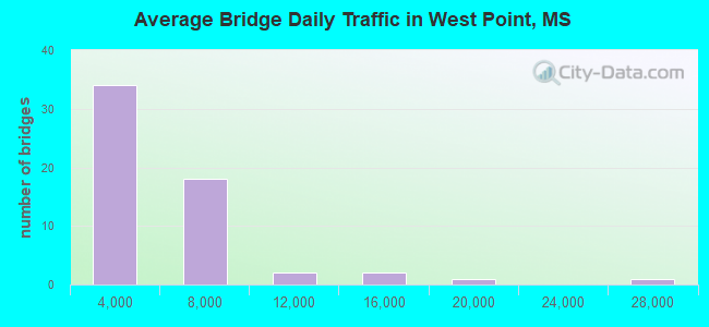
- 196,835Total average daily traffic
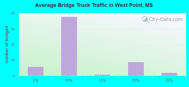
- 23,448Total average daily truck traffic
- 228,540Total future (year 2032) average daily traffic
- National Bridge Inventory (NBI) Registered Bridges for West Point
- No street view available for this location
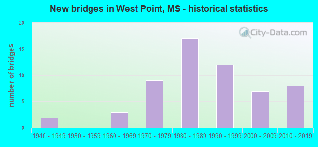
- New bridges - historical statistics
- 21940-1949
- 31960-1969
- 91970-1979
- 171980-1989
- 121990-1999
- 72000-2009
- 82010-2019
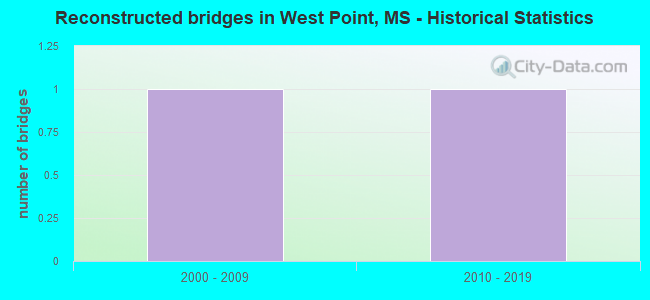
- Reconstructed bridges - Historical Statistics
- 12000-2009
- 12010-2019
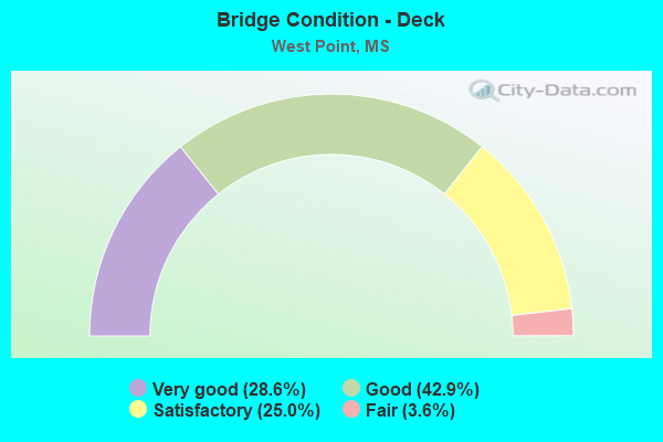
- Bridge Condition - Deck
- 28.6%Very good
- 42.9%Good
- 25.0%Satisfactory
- 3.6%Fair
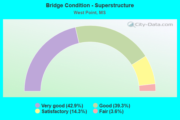
- Bridge Condition - Superstructure
- 42.9%Very good
- 39.3%Good
- 14.3%Satisfactory
- 3.6%Fair
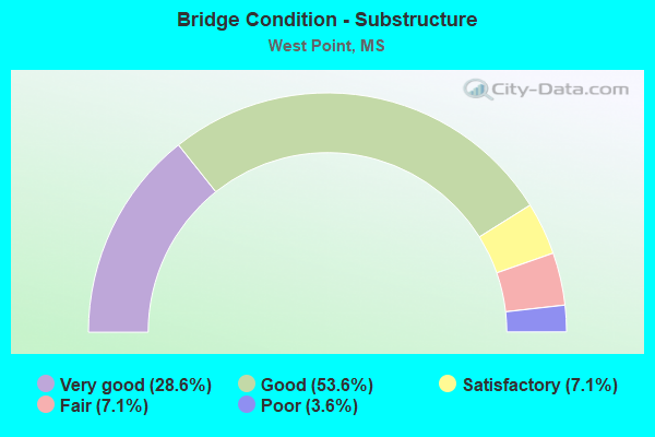
- Bridge Condition - Substructure
- 28.6%Very good
- 53.6%Good
- 7.1%Satisfactory
- 7.1%Fair
- 3.6%Poor
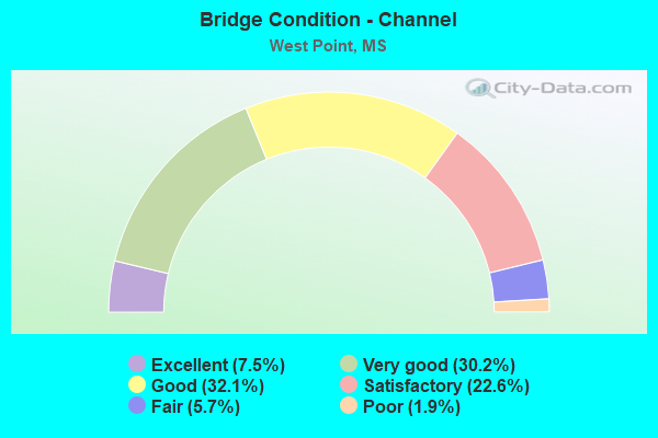
- Bridge Condition - Channel
- 7.5%Excellent
- 30.2%Very good
- 32.1%Good
- 22.6%Satisfactory
- 5.7%Fair
- 1.9%Poor
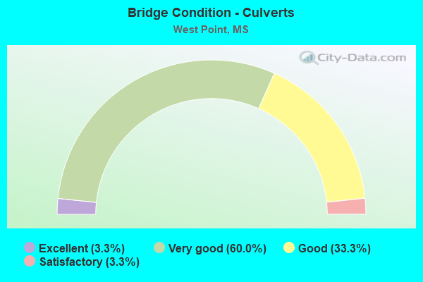
- Bridge Condition - Culverts
- 3.3%Excellent
- 60.0%Very good
- 33.3%Good
- 3.3%Satisfactory
Find on map >> Show street view
Structure Number: SA1300000000097, Location: SEC 21 T17S R 7E B (Lat: 33.579353, Lng: -88.565597), Route carried "on" structure: County highway 1715, Year Built: 1973, Status: Open, Structure Length: 3.66m (12.01ft), Average Daily Traffic: 790 (year 2021), Truck Traffic: 8%, Average Future Daily Traffic: 1,305 (year 2043), Design Load: H 15, Features Intersected: SPRING CREEK, Facility Carried by Structure: WAVERLY RD
Minimum Vertical Clearance: 30+ m (98+ ft), Kilometerpoint: 7.242, Lanes on structure: 2, Owner: County Highway Agency, Approaching Roadway Width: 9.1m (29.9ft), Material/Design: Prestressed concrete, Design/Construction: Stringer/Multi-beam, Number Of Spans In Main Unit: 3, Length of Maximum Span: 12.2m (40.0ft), Curb-To-Curb Width: 7.9m (25.9ft), Out-to-Out Width: 8.4m (27.6ft)
Condition: Deck: Very good, Superstructure: Very good, Substructure: Very good, Channel: Very good, Operating Rating: 49.7 metric tons, Method Used To Determine Operating Rating: Load Factor (LF), Inventory Rating: 30.1 metric tons, Method Used To Determine Inventory Rating: Load Factor (LF), Structural Evaluation: Better than present minimum criteria, Deck Geometry: Somewhat better than minimum adequacy, Waterway Adequacy: Equal to present desirable criteria, Approach Roadway Alignment: Equal to present desirable criteria, Length Of Structure Improvement: 4.39m (14.40ft), Designated Inspection Frequency: Every 24 months, Inspection Date: January 2022, Bridge Improvement Cost: $150,000, Roadway Improvement Cost: $150,000, Total Project Cost: $302,000 ( Estimate for 2022), Deck Structure Type: Concrete Precast Panels, Wearing Surface/Protective System: Wearing Surface: Monolithic Concrete
Find on map >> Show street view
Structure Number: SA13000000001, Location: SEC 28 T17S R 7E (Lat: 33.572281, Lng: -88.562400), Route carried "on" structure: County highway 182, Year Built: 1980, Status: Open, Structure Length: 3.78m (12.40ft), Average Daily Traffic: 50 (year 2021), Truck Traffic: 8%, Average Future Daily Traffic: 75 (year 2043), Design Load: H 15, Features Intersected: SPRING CREEK, Facility Carried by Structure: MATTHEWS GIN ROAD
Minimum Vertical Clearance: 30+ m (98+ ft), Kilometerpoint: 0.965, Lanes on structure: 2, Owner: County Highway Agency, Approaching Roadway Width: 6.7m (22.0ft), Material/Design: Concrete, Design/Construction: Channel Beam, Number Of Spans In Main Unit: 4, Length of Maximum Span: 9.4m (30.8ft), Curb-To-Curb Width: 8.2m (26.9ft), Out-to-Out Width: 8.7m (28.5ft)
Condition: Deck: Satisfactory, Superstructure: Satisfactory, Substructure: Satisfactory, Channel: Good, Operating Rating: 52.6 metric tons, Method Used To Determine Operating Rating: Load Factor (LF), Inventory Rating: 31.4 metric tons, Method Used To Determine Inventory Rating: Load Factor (LF), Structural Evaluation: Equal to present minimum criteria, Deck Geometry: Equal to present minimum criteria, Waterway Adequacy: Better than present minimum criteria, Approach Roadway Alignment: Equal to present desirable criteria, Length Of Structure Improvement: 8.29m (27.20ft), Designated Inspection Frequency: Every 24 months, Inspection Date: January 2022, Bridge Improvement Cost: $245,000, Roadway Improvement Cost: $130,000, Total Project Cost: $457,000 ( Estimate for 2022), Deck Structure Type: Concrete Precast Panels, Wearing Surface/Protective System: Wearing Surface: Monolithic Concrete
Find on map >> Show street view
Structure Number: SA1300000000102, Location: SEC 2 T18S R 6E B (Lat: 33.538278, Lng: -88.632225), Route carried "on" structure: County highway 15, Year Built: 2001, Status: Open, Structure Length: 14.04m (46.06ft), Average Daily Traffic: 50 (year 2021), Truck Traffic: 8%, Average Future Daily Traffic: 75 (year 2043), Design Load: HS 20, Features Intersected: TIBBEE CREEK, Facility Carried by Structure: MILLER BRO RD
Minimum Vertical Clearance: 30+ m (98+ ft), Kilometerpoint: 1.126, Lanes on structure: 2, Owner: County Highway Agency, Approaching Roadway Width: 8.4m (27.6ft), Material/Design: Prestressed concrete, Design/Construction: Stringer/Multi-beam, Number Of Spans In Main Unit: 10, Length of Maximum Span: 30.6m (100.4ft), Curb-To-Curb Width: 8.6m (28.2ft), Out-to-Out Width: 9.5m (31.2ft)
Condition: Deck: Very good, Superstructure: Very good, Substructure: Very good, Channel: Good, Operating Rating: 64.7 metric tons, Method Used To Determine Operating Rating: Load Factor (LF), Inventory Rating: 27.8 metric tons, Method Used To Determine Inventory Rating: Load Factor (LF), Structural Evaluation: Equal to present minimum criteria, Deck Geometry: Better than present minimum criteria, Waterway Adequacy: Equal to present desirable criteria, Approach Roadway Alignment: Equal to present desirable criteria, Designated Inspection Frequency: Every 24 months, Inspection Date: January 2022, Deck Structure Type: Concrete Cast-file-Place, Wearing Surface/Protective System: Wearing Surface: Gravel
Find on map >> Show street view
Structure Number: SA1300000000118, Location: SEC 25 T17S R 6E (Lat: 33.570611, Lng: -88.628386), Route carried "on" structure: County highway 36, Year Built: 1999, Status: Open, Structure Length: 0.61m (2.00ft), Average Daily Traffic: 50 (year 2021), Truck Traffic: 8%, Average Future Daily Traffic: 75 (year 2043), Design Load: HS 20, Features Intersected: SECTION CREEK, Facility Carried by Structure: SECTION ROAD
Minimum Vertical Clearance: 30+ m (98+ ft), Kilometerpoint: 1.246, Lanes on structure: 2, Owner: County Highway Agency, Approaching Roadway Width: 6.6m (21.7ft), Skew: 3 degrees, Material/Design: Concrete, Design/Construction: Culvert, Number Of Spans In Main Unit: 1, Length of Maximum Span: 6.1m (20.0ft), Curb-To-Curb Width: 8.7m (28.5ft), Out-to-Out Width: 9.0m (29.5ft)
Condition: Channel: Fair, Culverts: Very good, Operating Rating: 56.4 metric tons, Method Used To Determine Operating Rating: Load Factor (LF) rating reported by rating factor (RF) method using MS18 loading, Inventory Rating: 33.7 metric tons, Method Used To Determine Inventory Rating: Load Factor (LF) rating reported by rating factor (RF) method using MS18 loading, Structural Evaluation: Equal to present desirable criteria, Deck Geometry: Better than present minimum criteria, Waterway Adequacy: Better than present minimum criteria, Approach Roadway Alignment: Better than present minimum criteria, Designated Inspection Frequency: Every 24 months, Inspection Date: January 2020
Find on map >> Show street view
Structure Number: SA1300000000119, Location: SEC 10 T17S R 6E (Lat: 33.607056, Lng: -88.658583), Route carried "on" structure: City street 50, Year Built: 2010, Status: Open, Structure Length: 1.74m (5.71ft), Average Daily Traffic: 13,000 (year 2021), Truck Traffic: 8%, Average Future Daily Traffic: 19,500 (year 2043), Design Load: HS 20, Features Intersected: TOWN CREEK
Minimum Vertical Clearance: 30+ m (98+ ft), Kilometerpoint: 32.100, Lanes on structure: 2, Owner: City or Municipal Highway Agency, Approaching Roadway Width: 11.6m (38.1ft), Material/Design: Concrete, Design/Construction: Channel Beam, Number Of Spans In Main Unit: 3, Length of Maximum Span: 5.8m (19.0ft), Curb or Sidewalk Widths: Left: 0.2m (0.7ft), Right: 0.2m (0.7ft), Curb-To-Curb Width: 14.6m (47.9ft), Out-to-Out Width: 15.0m (49.2ft)
Condition: Deck: Satisfactory, Superstructure: Good, Substructure: Good, Channel: Good, Operating Rating: 53.6 metric tons, Method Used To Determine Operating Rating: Load Factor (LF), Inventory Rating: 32.1 metric tons, Method Used To Determine Inventory Rating: Load Factor (LF), Structural Evaluation: Better than present minimum criteria, Deck Geometry: Superior to present desirable criteria, Waterway Adequacy: Better than present minimum criteria, Approach Roadway Alignment: Equal to present desirable criteria, Length Of Structure Improvement: 2.44m (8.01ft), Designated Inspection Frequency: Every 24 months, Inspection Date: November 2021, Bridge Improvement Cost: $394,000, Roadway Improvement Cost: $316,000, Total Project Cost: $710,000 ( Estimate for 2021), Deck Structure Type: Concrete Precast Panels
Find on map >> Show street view
Structure Number: SA130000000012, Location: SEC 34 T16S R 6E B (Lat: 33.640669, Lng: -88.661894), Route carried "on" structure: County highway , Year Built: 2015, Status: Open, Structure Length: 1.48m (4.86ft), Average Daily Traffic: 5,000 (year 2021), Truck Traffic: 15%, Average Future Daily Traffic: 6,500 (year 2043), Design Load: HL 93, Features Intersected: UNNAMED STREAM, Facility Carried by Structure: YOKOHAMA ROAD
Minimum Vertical Clearance: 30+ m (98+ ft), Kilometerpoint: 6.120, Lanes on structure: 2, Owner: County Highway Agency, Approaching Roadway Width: 7.3m (24.0ft), Skew: 4 degrees, Material/Design: Concrete, Design/Construction: Culvert, Number Of Spans In Main Unit: 2, Length of Maximum Span: 4.9m (16.1ft), Curb-To-Curb Width: 29.3m (96.1ft), Out-to-Out Width: 29.8m (97.8ft)
Condition: Channel: Excellent, Culverts: Very good, Operating Rating: 58.5 metric tons, Method Used To Determine Operating Rating: Load Factor (LF), Inventory Rating: 35.0 metric tons, Method Used To Determine Inventory Rating: Load Factor (LF), Structural Evaluation: Equal to present desirable criteria, Deck Geometry: Superior to present desirable criteria, Waterway Adequacy: Superior to present desirable criteria, Approach Roadway Alignment: Equal to present desirable criteria, Designated Inspection Frequency: Every 24 months, Inspection Date: December 2021, Deck Structure Type: Concrete Cast-file-Place, Wearing Surface/Protective System: Wearing Surface: Monolithic Concrete
Find on map >> Show street view
Structure Number: SA1300000000121, Location: SEC 34 T16S R 6E B (Lat: 33.640781, Lng: -88.652900), Route carried "on" structure: County highway , Year Built: 2015, Status: Open, Structure Length: 10.97m (35.99ft), Average Daily Traffic: 5,000 (year 2021), Truck Traffic: 15%, Average Future Daily Traffic: 6,500 (year 2043), Design Load: Greater than HL93, Features Intersected: UNNAMED STREAM, Facility Carried by Structure: YOKOHAMA ROAD
Minimum Vertical Clearance: 30+ m (98+ ft), Kilometerpoint: 0.000, Lanes on structure: 20, Owner: County Highway Agency, Approaching Roadway Width: 7.3m (24.0ft), Material/Design: Prestressed concrete, Design/Construction: Tee Beam, Number Of Spans In Main Unit: 3, Length of Maximum Span: 36.6m (120.1ft), Curb-To-Curb Width: 12.2m (40.0ft), Out-to-Out Width: 13.1m (43.0ft)
Condition: Deck: Very good, Superstructure: Very good, Substructure: Very good, Channel: Excellent, Operating Rating: 47.4 metric tons, Method Used To Determine Operating Rating: Load Factor (LF), Inventory Rating: 43.5 metric tons, Method Used To Determine Inventory Rating: Load Factor (LF), Structural Evaluation: Equal to present desirable criteria, Deck Geometry: High priority of replacement, Waterway Adequacy: Superior to present desirable criteria, Approach Roadway Alignment: Equal to present desirable criteria, Designated Inspection Frequency: Every 24 months, Inspection Date: June 2020, Deck Structure Type: Concrete Cast-file-Place, Wearing Surface/Protective System: Wearing Surface: Monolithic Concrete
Find on map >> Show street view
Structure Number: SA1300000000122, Location: SEC 34 T16S R 6E B (Lat: 33.640722, Lng: -88.650214), Route carried "on" structure: County highway , Year Built: 2015, Status: Open, Structure Length: 10.97m (35.99ft), Average Daily Traffic: 5,000 (year 2021), Truck Traffic: 15%, Average Future Daily Traffic: 6,500 (year 2042), Design Load: Greater than HL93, Features Intersected: KCS RR, Facility Carried by Structure: YOKOHAMA ROAD
Minimum Vertical Clearance: 30+ m (98+ ft), Kilometerpoint: 4.500, Lanes on structure: 2, Owner: County Highway Agency, Approaching Roadway Width: 7.3m (24.0ft), Material/Design: Prestressed concrete, Design/Construction: Stringer/Multi-beam, Number Of Spans In Main Unit: 1, Number Of Approach Spans: 2, Length of Maximum Span: 36.6m (120.1ft), Curb-To-Curb Width: 12.2m (40.0ft), Out-to-Out Width: 13.6m (44.6ft)
Condition: Deck: Good, Superstructure: Good, Substructure: Good, Operating Rating: 54.5 metric tons, Method Used To Determine Operating Rating: Field evaluation and documented engineering judgment, Inventory Rating: 32.7 metric tons, Method Used To Determine Inventory Rating: Field evaluation and documented engineering judgment, Structural Evaluation: Better than present minimum criteria, Deck Geometry: Equal to present minimum criteria, Underclear: Meets minimum limits, Approach Roadway Alignment: Equal to present desirable criteria, Designated Inspection Frequency: Every 24 months, Inspection Date: November 2020, Deck Structure Type: Concrete Cast-file-Place, Wearing Surface/Protective System: Wearing Surface: Monolithic Concrete
Find on map >> Show street view
Structure Number: SA1300000000123, Location: SEC 35 T16S R 6E B (Lat: 33.638211, Lng: -88.634486), Route carried "on" structure: County highway , Year Built: 2015, Status: Open, Structure Length: 9.45m (31.00ft), Average Daily Traffic: 5,000 (year 2021), Truck Traffic: 15%, Average Future Daily Traffic: 6,500 (year 2043), Design Load: Greater than HL93, Features Intersected: KCS RR, Facility Carried by Structure: YOKOHAMA ROAD
Minimum Vertical Clearance: 30+ m (98+ ft), Kilometerpoint: 0.000, Lanes on structure: 2, Owner: County Highway Agency, Approaching Roadway Width: 7.3m (24.0ft), Material/Design: Prestressed concrete, Design/Construction: Tee Beam, Number Of Spans In Main Unit: 1, Number Of Approach Spans: 2, Length of Maximum Span: 36.6m (120.1ft), Curb-To-Curb Width: 12.6m (41.3ft), Out-to-Out Width: 13.1m (43.0ft)
Condition: Deck: Good, Superstructure: Good, Substructure: Good, Operating Rating: 52.8 metric tons, Method Used To Determine Operating Rating: Assigned ratings based on Load and Resistance Factor Design (LRFD) reported by rating factor (RF) using HL93 loadings, Inventory Rating: 40.5 metric tons, Method Used To Determine Inventory Rating: Assigned ratings based on Load and Resistance Factor Design (LRFD) reported by rating factor (RF) using HL93 loadings, Structural Evaluation: Better than present minimum criteria, Deck Geometry: Equal to present minimum criteria, Underclear: Meets minimum limits, Approach Roadway Alignment: Equal to present desirable criteria, Designated Inspection Frequency: Every 24 months, Inspection Date: March 2020, Deck Structure Type: Concrete Cast-file-Place, Wearing Surface/Protective System: Wearing Surface: Monolithic Concrete
Find on map >> Show street view
Structure Number: SA1300000000124, Location: SEC 35 T16S R 6E B (Lat: 33.637683, Lng: -88.632969), Route carried "on" structure: County highway , Year Built: 2015, Status: Open, Structure Length: 9.45m (31.00ft), Average Daily Traffic: 5,000 (year 2021), Truck Traffic: 15%, Average Future Daily Traffic: 6,500 (year 2043), Design Load: Greater than HL93, Features Intersected: ESHMAN ROAD, Facility Carried by Structure: YOKOHAMA ROAD
Minimum Vertical Clearance: 30+ m (98+ ft), Kilometerpoint: 0.000, Lanes on structure: 2, Lanes under structure: 2, Owner: County Highway Agency, Approaching Roadway Width: 7.3m (24.0ft), Skew: 1 degrees, Material/Design: Prestressed concrete, Design/Construction: Tee Beam, Number Of Spans In Main Unit: 3, Length of Maximum Span: 36.6m (120.1ft), Curb-To-Curb Width: 12.6m (41.3ft), Out-to-Out Width: 13.1m (43.0ft)
Condition: Deck: Very good, Superstructure: Very good, Substructure: Very good, Operating Rating: 47.4 metric tons, Method Used To Determine Operating Rating: Load Factor (LF), Inventory Rating: 43.5 metric tons, Method Used To Determine Inventory Rating: Load Factor (LF), Structural Evaluation: Equal to present desirable criteria, Deck Geometry: Equal to present minimum criteria, Underclear: Superior to present desirable criteria, Approach Roadway Alignment: Equal to present desirable criteria, Designated Inspection Frequency: Every 24 months, Inspection Date: January 2022, Deck Structure Type: Concrete Cast-file-Place, Wearing Surface/Protective System: Wearing Surface: Monolithic Concrete
Find on map >> Show street view
Structure Number: SA1300000000125, Location: SEC 36 T16S R 6E B (Lat: 33.637361, Lng: -88.617847), Route carried "on" structure: County highway , Year Built: 2015, Status: Open, Structure Length: 1.31m (4.30ft), Average Daily Traffic: 5,000 (year 2021), Truck Traffic: 15%, Average Future Daily Traffic: 6,500 (year 2043), Design Load: HS 20, Features Intersected: MCGEE CREEK, Facility Carried by Structure: YOKOHAMA ROAD
Minimum Vertical Clearance: 30+ m (98+ ft), Kilometerpoint: 0.000, Lanes on structure: 2, Owner: County Highway Agency, Approaching Roadway Width: 7.3m (24.0ft), Material/Design: Concrete, Design/Construction: Culvert, Number Of Spans In Main Unit: 2, Length of Maximum Span: 6.1m (20.0ft), Curb-To-Curb Width: 12.6m (41.3ft), Out-to-Out Width: 68.5m (224.7ft)
Condition: Culverts: Very good, Operating Rating: 73.6 metric tons, Method Used To Determine Operating Rating: Load Factor (LF), Inventory Rating: 44.1 metric tons, Method Used To Determine Inventory Rating: Load Factor (LF), Structural Evaluation: Equal to present desirable criteria, Deck Geometry: Equal to present minimum criteria, Waterway Adequacy: Superior to present desirable criteria, Approach Roadway Alignment: Equal to present desirable criteria, Designated Inspection Frequency: Every 24 months, Inspection Date: December 2021, Deck Structure Type: Concrete Cast-file-Place, Wearing Surface/Protective System: Wearing Surface: Monolithic Concrete
Find on map >> Show street view
Structure Number: SA130000000A067, Location: SEC 34 T`1S R 6E (Lat: 33.643583, Lng: -88.659750), Route carried "on" structure: County highway 149, Year Built: 2017, Status: Open, Structure Length: 0.77m (2.53ft), Average Daily Traffic: 50 (year 2021), Truck Traffic: 7%, Average Future Daily Traffic: 1,350 (year 2043), Design Load: HL 93, Features Intersected: TVA CREEK, Facility Carried by Structure: TVA STATION ROAD
Minimum Vertical Clearance: 30+ m (98+ ft), Kilometerpoint: 5.310, Lanes on structure: 2, Owner: County Highway Agency, Approaching Roadway Width: 6.1m (20.0ft), Skew: 1 degrees, Material/Design: Concrete, Design/Construction: Culvert, Number Of Spans In Main Unit: 2, Length of Maximum Span: 3.8m (12.5ft)
Condition: Channel: Very good, Culverts: Very good, Operating Rating: 66.3 metric tons, Method Used To Determine Operating Rating: Load Factor (LF), Inventory Rating: 39.9 metric tons, Method Used To Determine Inventory Rating: Load Factor (LF), Structural Evaluation: Equal to present desirable criteria, Waterway Adequacy: Equal to present desirable criteria, Approach Roadway Alignment: Equal to present desirable criteria, Designated Inspection Frequency: Every 24 months, Inspection Date: December 2021
Find on map >> Show street view
Structure Number: SA5300000000143, Location: SEC 2 T19N R15E (Lat: 33.547489, Lng: -88.690031), Route carried "on" structure: County highway 44, Year Built: 1990, Status: Open, Structure Length: 2.10m (6.89ft), Average Daily Traffic: 100 (year 2012), Average Future Daily Traffic: 150 (year 2032), Design Load: H 15, Features Intersected: ASH CREEK, Facility Carried by Structure: MULDROW ROAD
Minimum Vertical Clearance: 30+ m (98+ ft), Kilometerpoint: 1.287, Lanes on structure: 2, Owner: County Highway Agency, Approaching Roadway Width: 7.3m (24.0ft), Material/Design: Concrete, Design/Construction: Channel Beam, Number Of Spans In Main Unit: 3, Length of Maximum Span: 9.4m (30.8ft), Curb or Sidewalk Widths: Left: 0.2m (0.7ft), Right: 0.2m (0.7ft), Curb-To-Curb Width: 8.2m (26.9ft), Out-to-Out Width: 8.7m (28.5ft)
Condition: Deck: Good, Superstructure: Good, Substructure: Good, Channel: Fair, Operating Rating: 32.4 metric tons, Method Used To Determine Operating Rating: Allowable Stress (AS), Inventory Rating: 17.1 metric tons, Method Used To Determine Inventory Rating: Allowable Stress (AS), Structural Evaluation: Somewhat better than minimum adequacy, Deck Geometry: Equal to present minimum criteria, Waterway Adequacy: Better than present minimum criteria, Approach Roadway Alignment: Equal to present desirable criteria, Length Of Structure Improvement: 2.10m (6.89ft), Designated Inspection Frequency: Every 24 months, Inspection Date: December 2019, Bridge Improvement Cost: $32,000, Roadway Improvement Cost: $10,000, Total Project Cost: $46,000, Deck Structure Type: Concrete Precast Panels, Wearing Surface/Protective System: Wearing Surface: Monolithic Concrete
Find on map >> Show street view
Structure Number: SA5300000000145, Location: SEC 10 T19N R15E (Lat: 33.534306, Lng: -88.713528), Route carried "on" structure: County highway 249, Year Built: 1966, Status: Open, Structure Length: 1.74m (5.71ft), Average Daily Traffic: 150 (year 2021), Truck Traffic: 8%, Average Future Daily Traffic: 225 (year 2043), Design Load: H 15, Features Intersected: ASH CREEK, Facility Carried by Structure: OSBORN ROAD
Minimum Vertical Clearance: 30+ m (98+ ft), Kilometerpoint: 3.218, Lanes on structure: 2, Owner: County Highway Agency, Approaching Roadway Width: 5.5m (18.0ft), Material/Design: Concrete, Design/Construction: Channel Beam, Number Of Spans In Main Unit: 3, Length of Maximum Span: 5.8m (19.0ft), Curb or Sidewalk Widths: Left: 0.2m (0.7ft), Right: 0.2m (0.7ft), Curb-To-Curb Width: 7.1m (23.3ft), Out-to-Out Width: 7.5m (24.6ft)
Condition: Deck: Satisfactory, Superstructure: Satisfactory, Substructure: Fair, Channel: Satisfactory, Operating Rating: 56.1 metric tons, Method Used To Determine Operating Rating: Load Factor (LF), Inventory Rating: 33.6 metric tons, Method Used To Determine Inventory Rating: Load Factor (LF), Structural Evaluation: Somewhat better than minimum adequacy, Deck Geometry: Meets minimum limits, Waterway Adequacy: Equal to present minimum criteria, Approach Roadway Alignment: Equal to present desirable criteria, Length Of Structure Improvement: 2.44m (8.01ft), Designated Inspection Frequency: Every 12 months, Inspection Date: November 2021, Bridge Improvement Cost: $216,000, Roadway Improvement Cost: $173,000, Total Project Cost: $389,000 ( Estimate for 2021), Deck Structure Type: Concrete Precast Panels