Bridge Statistics for Westborough, Massachusetts (MA)
Condition, Traffic, Stress, Structural Evaluation, Project Costs
- National Bridge Inventory (NBI) Statistics
- 19Number of bridges
- 125ft / 38.3mTotal length
- $31,489,000Total costs
- 483,424Total average daily traffic
- 31,289Total average daily truck traffic
- National Bridge Inventory (NBI) Registered Bridges for Westborough
- No street view available for this location
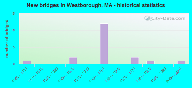
- New bridges - historical statistics
- 11900-1909
- 21930-1939
- 121950-1959
- 21970-1979
- 11980-1989
- 12000-2009

- Reconstructed bridges - Historical Statistics
- 11950-1959
- 01960-1969
- 01970-1979
- 61980-1989
- 11990-1999


- Bridge Condition - Deck
- 8.3%Good
- 66.7%Satisfactory
- 25.0%Fair

- Bridge Condition - Superstructure
- 16.7%Good
- 16.7%Satisfactory
- 66.7%Fair

- Bridge Condition - Substructure
- 33.3%Good
- 41.7%Satisfactory
- 25.0%Fair

- Bridge Condition - Channel
- 66.7%Good
- 33.3%Fair
Find on map >> Show street view
Structure Number: H230154NWDOTNBI, Location: I-90 MILE MARKER 104.9 (Lat: 42.250442, Lng: -71.585700), Route carried "on" structure: Interstate 90, Year Built: 1957, Year Reconstructed: 1988, Status: Open, Structure Length: 3.91m (12.83ft), Average Daily Traffic: 49,073 (year 2017), Truck Traffic: 12%, Average Future Daily Traffic: 140,935 (year 2031), Design Load: HS 20, Features Intersected: ST135 WOOD ST
Minimum Vertical Clearance: 30+ m (98+ ft), Kilometerpoint: 168.816, Lanes on structure: 6, Lanes under structure: 2, Base Highway Network: Yes, Toll: On toll road, Owner: State Highway Agency, Approaching Roadway Width: 16.3m (53.5ft), Skew: 11 degrees, Material/Design: Steel, Design/Construction: Stringer/Multi-beam, Number Of Spans In Main Unit: 1, Number Of Approach Spans: 2, Length of Maximum Span: 18.9m (62.0ft), Curb-To-Curb Width: 16.3m (53.5ft), Out-to-Out Width: 17.2m (56.4ft)
Condition: Deck: Satisfactory, Superstructure: Fair, Substructure: Satisfactory, Operating Rating: 61.4 metric tons, Method Used To Determine Operating Rating: Load Factor (LF), Inventory Rating: 36.7 metric tons, Method Used To Determine Inventory Rating: Load Factor (LF), Structural Evaluation: Somewhat better than minimum adequacy, Deck Geometry: High priority of replacement, Underclear: Meets minimum limits, Approach Roadway Alignment: Better than present minimum criteria, Length Of Structure Improvement: 4.00m (13.12ft), Designated Inspection Frequency: Every 24 months, Inspection Date: April 2020, Bridge Improvement Cost: $2,703,000, Roadway Improvement Cost: $271,000, Total Project Cost: $4,055,000 ( Estimate for 2022), Deck Structure Type: Concrete Cast-file-Place, Wearing Surface/Protective System: Wearing Surface: Bituminous, Membrane: Built-up, Deck Protection: Epoxy Coated Reinforcing
Find on map >> Show street view
Structure Number: H230154NXDOTNBI, Location: 1-90 MM 104.9 (Lat: 42.250544, Lng: -71.585967), Route carried "on" structure: Interstate 90, Year Built: 1957, Year Reconstructed: 1988, Status: Open, Structure Length: 3.91m (12.83ft), Average Daily Traffic: 48,720 (year 2017), Truck Traffic: 15%, Average Future Daily Traffic: 140,935 (year 2031), Design Load: HS 20, Features Intersected: ST135 WOOD ST
Minimum Vertical Clearance: 30+ m (98+ ft), Kilometerpoint: 168.816, Lanes on structure: 3, Lanes under structure: 2, Base Highway Network: Yes, Toll: On toll road, Owner: State Highway Agency, Approaching Roadway Width: 16.3m (53.5ft), Skew: 1 degrees, Material/Design: Steel, Design/Construction: Stringer/Multi-beam, Number Of Spans In Main Unit: 3, Length of Maximum Span: 18.9m (62.0ft), Curb-To-Curb Width: 16.3m (53.5ft), Out-to-Out Width: 17.2m (56.4ft)
Condition: Deck: Satisfactory, Superstructure: Fair, Substructure: Satisfactory, Operating Rating: 61.9 metric tons, Method Used To Determine Operating Rating: Load Factor (LF), Inventory Rating: 37.1 metric tons, Method Used To Determine Inventory Rating: Load Factor (LF), Structural Evaluation: Somewhat better than minimum adequacy, Deck Geometry: Equal to present minimum criteria, Underclear: Meets minimum limits, Approach Roadway Alignment: Better than present minimum criteria, Length Of Structure Improvement: 4.00m (13.12ft), Designated Inspection Frequency: Every 24 months, Inspection Date: April 2020, Bridge Improvement Cost: $2,703,000, Roadway Improvement Cost: $271,000, Total Project Cost: $4,055,000 ( Estimate for 2022), Deck Structure Type: Concrete Cast-file-Place, Wearing Surface/Protective System: Wearing Surface: Bituminous, Membrane: Built-up, Deck Protection: Epoxy Coated Reinforcing
Find on map >> Show street view
Structure Number: W2400722VDOT634, Location: 1 MI S OF ST-9 (Lat: 42.274314, Lng: -71.624914), Route carried "on" structure: State highway 135, Year Built: 1900, Year Reconstructed: 1963, Status: Open, Structure Length: 3.37m (11.06ft), Average Daily Traffic: 11,980 (year 2016), Truck Traffic: 7%, Average Future Daily Traffic: 20,531 (year 2032), Design Load: H 20, Features Intersected: RR MBTA/CSX
Minimum Vertical Clearance: 30+ m (98+ ft), Kilometerpoint: 5.536, Lanes on structure: 2, Owner: State Highway Agency, Approaching Roadway Width: 12.2m (40.0ft), Skew: 2 degrees, Material/Design: Steel, Design/Construction: Stringer/Multi-beam, Number Of Spans In Main Unit: 1, Number Of Approach Spans: 2, Length of Maximum Span: 21.6m (70.9ft), Curb or Sidewalk Widths: Left: 1.5m (4.9ft), Right: 0.4m (1.3ft), Curb-To-Curb Width: 12.2m (40.0ft), Out-to-Out Width: 14.9m (48.9ft)
Condition: Deck: Fair, Superstructure: Fair, Substructure: Fair, Operating Rating: 48.2 metric tons, Method Used To Determine Operating Rating: Allowable Stress (AS), Inventory Rating: 24.9 metric tons, Method Used To Determine Inventory Rating: Allowable Stress (AS), Structural Evaluation: Somewhat better than minimum adequacy, Deck Geometry: Somewhat better than minimum adequacy, Underclear: Meets minimum limits, Approach Roadway Alignment: Equal to present minimum criteria, Length Of Structure Improvement: 3.40m (11.15ft), Designated Inspection Frequency: Every 24 months, Inspection Date: June 2021, Bridge Improvement Cost: $1,990,000, Roadway Improvement Cost: $200,000, Total Project Cost: $2,986,000 ( Estimate for 2022), Deck Structure Type: Concrete Cast-file-Place, Wearing Surface/Protective System: Wearing Surface: Bituminous, Membrane: Built-up
Find on map >> Show street view
Structure Number: W24009230DOT634, Location: .7 MI S OF ST-9 (Lat: 42.270828, Lng: -71.641619), Route carried "on" structure: City street , Year Built: 1986, Status: Open, Structure Length: 1.74m (5.71ft), Average Daily Traffic: 9,762 (year 2018), Truck Traffic: 6%, Average Future Daily Traffic: 16,583 (year 2032), Design Load: H 20, Features Intersected: RR MBTA/CSX, Facility Carried by Structure: HWY OTIS ST
Minimum Vertical Clearance: 30+ m (98+ ft), Kilometerpoint: 0.161, Lanes on structure: 2, Owner: State Highway Agency, Approaching Roadway Width: 11.0m (36.1ft), Skew: 1 degrees, Material/Design: Prestressed concrete, Design/Construction: Slab, Number Of Spans In Main Unit: 1, Length of Maximum Span: 16.2m (53.1ft), Curb or Sidewalk Widths: Left: 0.0m, Right: 1.8m (5.9ft), Curb-To-Curb Width: 11.0m (36.1ft), Out-to-Out Width: 13.9m (45.6ft)
Condition: Deck: Fair, Superstructure: Fair, Substructure: Good, Operating Rating: 70.5 metric tons, Method Used To Determine Operating Rating: Load Factor (LF), Inventory Rating: 41.4 metric tons, Method Used To Determine Inventory Rating: Load Factor (LF), Structural Evaluation: Somewhat better than minimum adequacy, Deck Geometry: Meets minimum limits, Underclear: High priority of corrective action, Approach Roadway Alignment: Better than present minimum criteria, Length Of Structure Improvement: 1.80m (5.91ft), Designated Inspection Frequency: Every 24 months, Inspection Date: April 2021, Bridge Improvement Cost: $983,000, Roadway Improvement Cost: $99,000, Total Project Cost: $1,475,000 ( Estimate for 2022), Deck Structure Type: Concrete Precast Panels, Wearing Surface/Protective System: Wearing Surface: Bituminous, Membrane: Built-up
Find on map >> Show street view
Structure Number: W240141M2DOTNBI, Location: .8MI. W. OF LYMAN ST. (Lat: 42.283736, Lng: -71.632692), Route carried "on" structure: State highway 9, Year Built: 1930, Status: Open, Structure Length: 1.17m (3.84ft), Average Daily Traffic: 42,013 (year 2020), Truck Traffic: 5%, Average Future Daily Traffic: 87,177 (year 2032), Design Load: H 20, Features Intersected: ST135 MILK ST
Minimum Vertical Clearance: 30+ m (98+ ft), Kilometerpoint: 170.270, Lanes on structure: 6, Lanes under structure: 2, Base Highway Network: Yes, Owner: State Highway Agency, Approaching Roadway Width: 14.0m (45.9ft), Skew: 30 degrees, Material/Design: Concrete, Design/Construction: Tee Beam, Number Of Spans In Main Unit: 1, Length of Maximum Span: 10.8m (35.4ft), Curb or Sidewalk Widths: Left: 0.2m (0.7ft), Right: 0.2m (0.7ft), Curb-To-Curb Width: 14.0m (45.9ft), Out-to-Out Width: 29.6m (97.1ft)
Condition: Deck: Satisfactory, Superstructure: Fair, Substructure: Good, Operating Rating: 59.5 metric tons, Method Used To Determine Operating Rating: Load Factor (LF), Inventory Rating: 35.6 metric tons, Method Used To Determine Inventory Rating: Load Factor (LF), Structural Evaluation: Somewhat better than minimum adequacy, Deck Geometry: High priority of replacement, Underclear: High priority of corrective action, Approach Roadway Alignment: Equal to present desirable criteria, Length Of Structure Improvement: 1.20m (3.94ft), Designated Inspection Frequency: Every 24 months, Inspection Date: June 2021, Bridge Improvement Cost: $1,396,000, Roadway Improvement Cost: $140,000, Total Project Cost: $2,095,000 ( Estimate for 2022), Deck Structure Type: Concrete Cast-file-Place, Wearing Surface/Protective System: Wearing Surface: Bituminous, Membrane: Built-up
Find on map >> Show street view
Structure Number: W240151M1DOTNBI, Location: 1.5 MI. W. OF I-495 (Lat: 42.286522, Lng: -71.596006), Route carried "on" structure: State highway 9, Year Built: 1930, Year Reconstructed: 1989, Status: Open, Structure Length: 2.13m (6.99ft), Average Daily Traffic: 54,963 (year 2019), Truck Traffic: 4%, Average Future Daily Traffic: 90,020 (year 2032), Design Load: H 20, Features Intersected: ST 30 E MAIN ST
Minimum Vertical Clearance: 30+ m (98+ ft), Kilometerpoint: 173.241, Lanes on structure: 4, Lanes under structure: 2, Base Highway Network: Yes, Owner: State Highway Agency, Approaching Roadway Width: 9.4m (30.8ft), Skew: 35 degrees, Material/Design: Steel, Design/Construction: Stringer/Multi-beam, Number Of Spans In Main Unit: 1, Length of Maximum Span: 20.1m (65.9ft), Curb or Sidewalk Widths: Left: 0.2m (0.7ft), Right: 0.2m (0.7ft), Curb-To-Curb Width: 21.0m (68.9ft), Out-to-Out Width: 22.3m (73.2ft)
Condition: Deck: Satisfactory, Superstructure: Satisfactory, Substructure: Satisfactory, Operating Rating: 66.3 metric tons, Method Used To Determine Operating Rating: Load Factor (LF), Inventory Rating: 39.8 metric tons, Method Used To Determine Inventory Rating: Load Factor (LF), Structural Evaluation: Equal to present minimum criteria, Deck Geometry: Superior to present desirable criteria, Underclear: High priority of corrective action, Approach Roadway Alignment: Equal to present desirable criteria, Length Of Structure Improvement: 2.20m (7.22ft), Designated Inspection Frequency: Every 24 months, Inspection Date: April 2021, Bridge Improvement Cost: $229,000, Roadway Improvement Cost: $23,000, Total Project Cost: $344,000 ( Estimate for 2022), Deck Structure Type: Concrete Cast-file-Place, Wearing Surface/Protective System: Wearing Surface: Bituminous
Find on map >> Show street view
Structure Number: W240171J6MUNNBI, Location: .5 MI. WEST OF ROUTE 135 (Lat: 42.274083, Lng: -71.632197), Route carried "on" structure: City street , Year Built: 1956, Status: Open, Structure Length: 0.68m (2.23ft), Average Daily Traffic: 1,170 (year 2017), Truck Traffic: 2%, Average Future Daily Traffic: 1,848 (year 2032), Design Load: H 15, Features Intersected: WATER ASSABET RIVER, Facility Carried by Structure: HWY MAYNARD ST
Minimum Vertical Clearance: 30+ m (98+ ft), Kilometerpoint: 0.515, Lanes on structure: 2, Owner: Town or Township Highway Agency, Approaching Roadway Width: 7.9m (25.9ft), Material/Design: Prestressed concrete, Design/Construction: Slab, Number Of Spans In Main Unit: 1, Length of Maximum Span: 6.0m (19.7ft), Curb or Sidewalk Widths: Left: 1.5m (4.9ft), Right: 0.3m (1.0ft), Curb-To-Curb Width: 7.9m (25.9ft), Out-to-Out Width: 9.8m (32.2ft)
Condition: Deck: Satisfactory, Superstructure: Satisfactory, Substructure: Satisfactory, Channel: Good, Operating Rating: 71.0 metric tons, Method Used To Determine Operating Rating: Load Factor (LF), Inventory Rating: 42.5 metric tons, Method Used To Determine Inventory Rating: Load Factor (LF), Structural Evaluation: Equal to present minimum criteria, Deck Geometry: Meets minimum limits, Waterway Adequacy: Better than present minimum criteria, Approach Roadway Alignment: Better than present minimum criteria, Length Of Structure Improvement: 0.70m (2.30ft), Designated Inspection Frequency: Every 24 months, Inspection Date: November 2021, Bridge Improvement Cost: $362,000, Roadway Improvement Cost: $37,000, Total Project Cost: $544,000 ( Estimate for 2022), Deck Structure Type: Concrete Precast Panels, Wearing Surface/Protective System: Wearing Surface: Bituminous, Membrane: Built-up, Deck Protection: Epoxy Coated Reinforcing
Find on map >> Show street view
Structure Number: W240181J7MUNNBI, Location: @ THE CORNER OF BROOK WAY (Lat: 42.256208, Lng: -71.633992), Route carried "on" structure: City street , Year Built: 1956, Status: Open, Structure Length: 0.69m (2.26ft), Average Daily Traffic: 1,300 (year 2013), Truck Traffic: 1%, Average Future Daily Traffic: 2,053 (year 2032), Design Load: H 15, Features Intersected: WATER ASSABET RIVER, Facility Carried by Structure: HWY OLD NOURS ST
Minimum Vertical Clearance: 30+ m (98+ ft), Kilometerpoint: 0.097, Lanes on structure: 2, Owner: Town or Township Highway Agency, Approaching Roadway Width: 8.0m (26.2ft), Material/Design: Prestressed concrete, Design/Construction: Slab, Number Of Spans In Main Unit: 1, Length of Maximum Span: 6.5m (21.3ft), Curb or Sidewalk Widths: Left: 0.2m (0.7ft), Right: 0.2m (0.7ft), Curb-To-Curb Width: 8.0m (26.2ft), Out-to-Out Width: 8.6m (28.2ft)
Condition: Deck: Good, Superstructure: Good, Substructure: Good, Channel: Fair, Inventory Rating: 61.5 metric tons, Method Used To Determine Inventory Rating: Load Factor (LF), Structural Evaluation: Better than present minimum criteria, Deck Geometry: Meets minimum limits, Waterway Adequacy: Better than present minimum criteria, Approach Roadway Alignment: Better than present minimum criteria, Length Of Structure Improvement: 0.70m (2.30ft), Designated Inspection Frequency: Every 24 months, Inspection Date: August 2021, Bridge Improvement Cost: $357,000, Roadway Improvement Cost: $36,000, Total Project Cost: $536,000 ( Estimate for 2022), Deck Structure Type: Concrete Precast Panels, Wearing Surface/Protective System: Wearing Surface: Bituminous, Membrane: Built-up
Find on map >> Show street view
Structure Number: W24028AXXMUNNBI, Location: .3 MI S OF FISHER ST. (Lat: 42.269414, Lng: -71.633394), Route carried "on" structure: City street , Year Built: 2003, Status: Open, Structure Length: 0.70m (2.30ft), Average Daily Traffic: 2,000 (year 2012), Average Future Daily Traffic: 4,738 (year 2031), Design Load: HS 25 or greater, Features Intersected: WATER ASSABET RIVER, Facility Carried by Structure: HWY MILL RD
Minimum Vertical Clearance: 30+ m (98+ ft), Kilometerpoint: 0.241, Lanes on structure: 2, Owner: Town or Township Highway Agency, Approaching Roadway Width: 8.0m (26.2ft), Skew: 1 degrees, Material/Design: Concrete, Design/Construction: Culvert, Number Of Spans In Main Unit: 2, Length of Maximum Span: 3.2m (10.5ft)
Condition: Channel: Good, Culverts: Good, Structural Evaluation: Better than present minimum criteria, Waterway Adequacy: Superior to present desirable criteria, Approach Roadway Alignment: Better than present minimum criteria, Length Of Structure Improvement: 0.60m (1.97ft), Designated Inspection Frequency: Every 24 months, Inspection Date: September 2020, Bridge Improvement Cost: $377,000, Roadway Improvement Cost: $38,000, Total Project Cost: $566,000 ( Estimate for 2022)
Find on map >> Show street view
Structure Number: W240294NKDOTNBI, Location: .5 MI N OF UPTON TWN LN (Lat: 42.233356, Lng: -71.609356), Route carried "on" structure: Interstate 90, Year Built: 1957, Year Reconstructed: 1987, Status: Open, Structure Length: 1.46m (4.79ft), Average Daily Traffic: 49,905 (year 2019), Truck Traffic: 12%, Average Future Daily Traffic: 97,198 (year 2032), Design Load: HS 20, Features Intersected: HWY BOWMAN ST
Minimum Vertical Clearance: 30+ m (98+ ft), Kilometerpoint: 166.080, Lanes on structure: 3, Lanes under structure: 2, Base Highway Network: Yes, Toll: On toll road, Owner: State Highway Agency, Approaching Roadway Width: 16.5m (54.1ft), Skew: 3 degrees, Material/Design: Steel, Design/Construction: Stringer/Multi-beam, Number Of Spans In Main Unit: 1, Length of Maximum Span: 12.8m (42.0ft), Curb-To-Curb Width: 15.2m (49.9ft), Out-to-Out Width: 17.2m (56.4ft)
Condition: Deck: Satisfactory, Superstructure: Fair, Substructure: Satisfactory, Operating Rating: 57.1 metric tons, Method Used To Determine Operating Rating: Load Factor (LF), Inventory Rating: 34.2 metric tons, Method Used To Determine Inventory Rating: Load Factor (LF), Structural Evaluation: Somewhat better than minimum adequacy, Deck Geometry: Meets minimum limits, Underclear: High priority of corrective action, Approach Roadway Alignment: Equal to present desirable criteria, Length Of Structure Improvement: 1.50m (4.92ft), Designated Inspection Frequency: Every 24 months, Inspection Date: Febuary 2021, Bridge Improvement Cost: $1,014,000, Roadway Improvement Cost: $102,000, Total Project Cost: $1,522,000 ( Estimate for 2022), Deck Structure Type: Concrete Cast-file-Place, Wearing Surface/Protective System: Wearing Surface: Bituminous, Membrane: Built-up, Deck Protection: Epoxy Coated Reinforcing
Find on map >> Show street view
Structure Number: W240294NLDOTNBI, Location: .5 MI N OF UPTON TWN LN (Lat: 42.233564, Lng: -71.609358), Route carried "on" structure: Interstate 90, Year Built: 1957, Year Reconstructed: 1987, Status: Open, Structure Length: 1.46m (4.79ft), Average Daily Traffic: 50,236 (year 2019), Truck Traffic: 12%, Average Future Daily Traffic: 97,198 (year 2032), Design Load: HS 20, Features Intersected: HWY BOWMAN ST
Minimum Vertical Clearance: 30+ m (98+ ft), Kilometerpoint: 166.080, Lanes on structure: 3, Lanes under structure: 2, Base Highway Network: Yes, Toll: On toll road, Owner: State Highway Agency, Approaching Roadway Width: 16.5m (54.1ft), Skew: 3 degrees, Material/Design: Steel, Design/Construction: Stringer/Multi-beam, Number Of Spans In Main Unit: 1, Length of Maximum Span: 12.8m (42.0ft), Curb-To-Curb Width: 15.2m (49.9ft), Out-to-Out Width: 17.2m (56.4ft)
Condition: Deck: Fair, Superstructure: Fair, Substructure: Good, Operating Rating: 57.1 metric tons, Method Used To Determine Operating Rating: Load Factor (LF), Inventory Rating: 34.2 metric tons, Method Used To Determine Inventory Rating: Load Factor (LF), Structural Evaluation: Somewhat better than minimum adequacy, Deck Geometry: Meets minimum limits, Underclear: High priority of corrective action, Approach Roadway Alignment: Equal to present desirable criteria, Length Of Structure Improvement: 1.50m (4.92ft), Designated Inspection Frequency: Every 24 months, Inspection Date: Febuary 2021, Bridge Improvement Cost: $1,014,000, Roadway Improvement Cost: $102,000, Total Project Cost: $1,522,000 ( Estimate for 2022), Deck Structure Type: Concrete Cast-file-Place, Wearing Surface/Protective System: Wearing Surface: Bituminous, Membrane: Built-up, Deck Protection: Epoxy Coated Reinforcing
Find on map >> Show street view
Structure Number: W240304NJDOTNBI, Location: 0.75 MI W OF REST AREA (Lat: 42.236011, Lng: -71.604156), Route carried "on" structure: City street , Year Built: 1957, Year Reconstructed: 1995, Status: Open, Structure Length: 10.76m (35.30ft), Average Daily Traffic: 5,542 (year 2019), Truck Traffic: 5%, Average Future Daily Traffic: 5,054 (year 2032), Design Load: HS 20, Features Intersected: I 90, Facility Carried by Structure: HWY UPTON RD
Minimum Vertical Clearance: 4.64m (15.22ft), Kilometerpoint: 166.723, Lanes on structure: 2, Lanes under structure: 6, Owner: State Highway Agency, Approaching Roadway Width: 9.1m (29.9ft), Skew: 5 degrees, Material/Design: Steel continuous, Design/Construction: Stringer/Multi-beam, Number Of Spans In Main Unit: 3, Number Of Approach Spans: 1, Length of Maximum Span: 33.2m (108.9ft), Curb or Sidewalk Widths: Left: 1.5m (4.9ft), Right: 0.8m (2.6ft), Curb-To-Curb Width: 9.1m (29.9ft), Out-to-Out Width: 12.3m (40.4ft)
Condition: Deck: Satisfactory, Superstructure: Good, Substructure: Fair, Operating Rating: 42.9 metric tons, Method Used To Determine Operating Rating: Load Factor (LF), Inventory Rating: 25.7 metric tons, Method Used To Determine Inventory Rating: Load Factor (LF), Structural Evaluation: Somewhat better than minimum adequacy, Deck Geometry: Meets minimum limits, Underclear: High priority of corrective action, Approach Roadway Alignment: Equal to present desirable criteria, Length Of Structure Improvement: 10.80m (35.43ft), Designated Inspection Frequency: Every 24 months, Inspection Date: January 2021, Bridge Improvement Cost: $5,218,000, Roadway Improvement Cost: $522,000, Total Project Cost: $7,828,000 ( Estimate for 2022), Deck Structure Type: Concrete Cast-file-Place, Wearing Surface/Protective System: Wearing Surface: Monolithic Concrete, Membrane: Built-up, Deck Protection: Epoxy Coated Reinforcing
Find on map >> Show street view
Structure Number: W240314NHDOTNBI, Location: AT I-90 MM 103.9 (Lat: 42.239092, Lng: -71.598994), Route carried "on" structure: City street , Year Built: 1957, Year Reconstructed: 1994, Status: Open, Structure Length: 6.36m (20.87ft), Average Daily Traffic: 860 (year 2018), Truck Traffic: 5%, Average Future Daily Traffic: 790 (year 2032), Design Load: HS 20, Features Intersected: I 90, Facility Carried by Structure: HWY SPRING RD
Minimum Vertical Clearance: 30+ m (98+ ft), Kilometerpoint: 167.206, Lanes on structure: 2, Lanes under structure: 6, Owner: State Highway Agency, Approaching Roadway Width: 7.3m (24.0ft), Skew: 3 degrees, Material/Design: Steel continuous, Design/Construction: Stringer/Multi-beam, Number Of Spans In Main Unit: 2, Number Of Approach Spans: 2, Length of Maximum Span: 22.2m (72.8ft), Curb or Sidewalk Widths: Left: 0.8m (2.6ft), Right: 1.5m (4.9ft), Curb-To-Curb Width: 7.3m (24.0ft), Out-to-Out Width: 10.5m (34.4ft)
Condition: Deck: Satisfactory, Superstructure: Fair, Substructure: Fair, Operating Rating: 43.5 metric tons, Method Used To Determine Operating Rating: Load Factor (LF), Inventory Rating: 26.0 metric tons, Method Used To Determine Inventory Rating: Load Factor (LF), Structural Evaluation: Somewhat better than minimum adequacy, Deck Geometry: Meets minimum limits, Underclear: High priority of corrective action, Approach Roadway Alignment: Equal to present desirable criteria, Length Of Structure Improvement: 6.40m (21.00ft), Designated Inspection Frequency: Every 24 months, Inspection Date: October 2020, Bridge Improvement Cost: $2,640,000, Roadway Improvement Cost: $265,000, Total Project Cost: $3,961,000 ( Estimate for 2022), Deck Structure Type: Concrete Cast-file-Place, Wearing Surface/Protective System: Wearing Surface: Monolithic Concrete, Deck Protection: Epoxy Coated Reinforcing
Find on map >> Show street view
Structure Number: W240261M3DOTNBI, Location: LYONS ST/ST 9 (Lat: 42.283333, Lng: -71.583333), Route carried "under" structure: State highway 9, Year Built: 1974, Structure Length: 0. m, Average Daily Traffic: 22,000 (year 0000), Features Intersected: ST 9 WB, Facility Carried by Structure: HWY LYONS ST
Minimum Vertical Clearance: 5.08m (16.67ft), Kilometerpoint: 0.000, Lanes on structure: 4, Lanes under structure: 4, Material/Design: Steel, Design/Construction: Stringer/Multi-beam, Length of Maximum Span: 36.6m (120.1ft)
Find on map >> Show street view
Structure Number: W240261M3DOTNBI, Location: LYONS ST/ST 9 (Lat: 42.283333, Lng: -71.583333), Route carried "under" structure: State highway 9, Year Built: 1974, Structure Length: 0. m, Average Daily Traffic: 22,000 (year 0000), Features Intersected: ST 9 EB, Facility Carried by Structure: HWY LYONS ST
Minimum Vertical Clearance: 5.08m (16.67ft), Kilometerpoint: 0.000, Lanes on structure: 4, Lanes under structure: 4, Material/Design: Steel, Design/Construction: Stringer/Multi-beam, Length of Maximum Span: 36.6m (120.1ft)
Find on map >> Show street view
Structure Number: W240304NJDOTNBI, Location: .5 MI NORTH UPTON TWN LN (Lat: 42.233333, Lng: -71.600000), Route carried "under" structure: Interstate 90, Year Built: 1957, Structure Length: 0. m, Average Daily Traffic: 28,000 (year 0000), Features Intersected: I 90 WB, Facility Carried by Structure: HWY UPTON RD
Minimum Vertical Clearance: 4.27m (14.01ft), Kilometerpoint: 166.723, Lanes on structure: 2, Lanes under structure: 6, Toll: On toll road, Material/Design: Steel, Design/Construction: Stringer/Multi-beam, Length of Maximum Span: 33.2m (108.9ft)
Find on map >> Show street view
Structure Number: W240304NJDOTNBI, Location: .5 MI NORTH UPTON TWN LN (Lat: 42.233333, Lng: -71.600000), Route carried "under" structure: Interstate 90, Year Built: 1957, Structure Length: 0. m, Average Daily Traffic: 27,900 (year 0000), Features Intersected: I 90 EB, Facility Carried by Structure: HWY UPTON RD
Minimum Vertical Clearance: 4.27m (14.01ft), Kilometerpoint: 166.723, Lanes on structure: 2, Lanes under structure: 6, Toll: On toll road, Material/Design: Steel, Design/Construction: Stringer/Multi-beam, Length of Maximum Span: 33.2m (108.9ft)
Find on map >> Show street view
Structure Number: W240314NHDOTNBI, Location: 1 MI NORTH UPTON TWN LINE (Lat: 42.233333, Lng: -71.600000), Route carried "under" structure: Interstate 90, Year Built: 1957, Structure Length: 0. m, Average Daily Traffic: 28,000 (year 2000), Features Intersected: I 90 WB, Facility Carried by Structure: HWY SPRING RD
Minimum Vertical Clearance: 4.78m (15.68ft), Kilometerpoint: 167.206, Lanes on structure: 3, Lanes under structure: 2, Toll: On toll road, Material/Design: Steel, Design/Construction: Stringer/Multi-beam, Length of Maximum Span: 22.3m (73.2ft)
Find on map >> Show street view
Structure Number: W240314NHDOTNBI, Location: 1 MI NORTH UPTON TWN LINE (Lat: 42.233333, Lng: -71.600000), Route carried "under" structure: Interstate 90, Year Built: 1957, Structure Length: 0. m, Average Daily Traffic: 28,000 (year 2000), Features Intersected: I 90 EB, Facility Carried by Structure: HWY SPRING RD
Minimum Vertical Clearance: 4.78m (15.68ft), Kilometerpoint: 167.206, Lanes on structure: 3, Lanes under structure: 2, Toll: On toll road, Material/Design: Steel, Design/Construction: Stringer/Multi-beam, Length of Maximum Span: 22.3m (73.2ft)