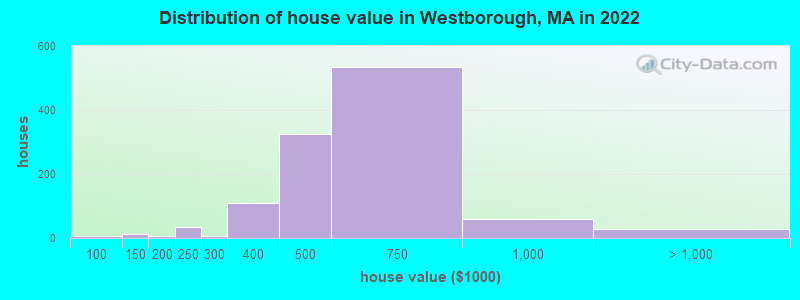
Estimated median house or condo value in 2022: $539,632 (it was $201,300 in 2000)
Westborough:
$539,632
MA:
$534,700
Mean prices in 2022:all housing units: $419,164; detached houses: $447,621; townhouses or other attached units: $343,592; in 2-unit structures: $323,295; in 3-to-4-unit structures: $332,295; in 5-or-more-unit structures: $232,758; mobile homes: $113,885
Median gross rent in 2022: $1,481.
March 2022 cost of living index in Westborough: 130.1 (high, U.S. average is 100)
Percentage of residents living in poverty in 2022: 6.9%
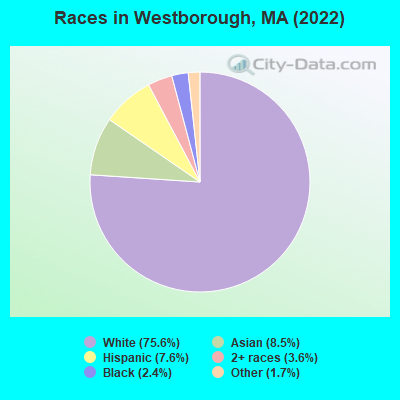
(4.3% for White Non-Hispanic residents, 3.7% for Black residents, 29.5% for Hispanic or Latino residents, 53.8% for other race residents, 1.7% for two or more races residents)
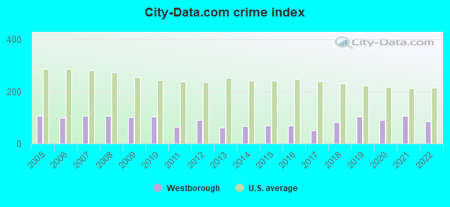
The City-Data.com crime index weighs serious crimes and violent crimes more heavily. Higher means more crime, U.S. average is 246.1. It adjusts for the number of visitors and daily workers commuting into cities.
Latest news from Westborough, MA collected exclusively by city-data.com from local newspapers, TV, and radio stations
Ancestries: Irish (10.9%), Italian (9.5%), English (7.1%), Polish (7.1%), American (4.8%), German (3.2%).
Current Local Time: EST time zone
Incorporated in 1717
Elevation: 300 feet
Land area: 1.90 square miles.
Population density: 2,125 people per square mile (low).
645 residents are foreign born (6.2% Asia, 3.3% Latin America, 3.2% Europe).
This place:
14.7%
Massachusetts:
17.6%
Median real estate property taxes paid for housing units with mortgages in 2022: $8,519 (1.6%) Median real estate property taxes paid for housing units with no mortgage in 2022: $7,528 (1.4%)
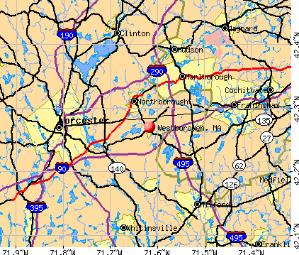
Nearest city with pop. 50,000+: Worcester, MA (9.5 miles , pop. 172,648).
Nearest city with pop. 200,000+: Boston, MA (27.3 miles , pop. 589,141).
Nearest city with pop. 1,000,000+: Bronx, NY (152.7 miles , pop. 1,332,650).
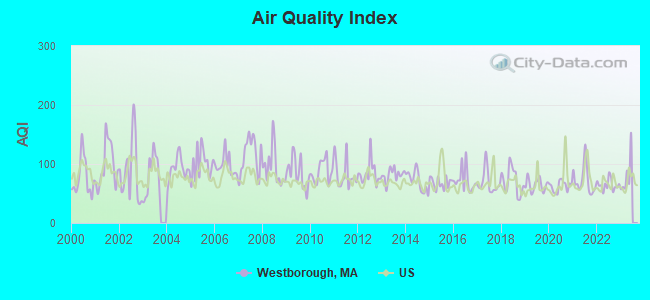
Air Quality Index (AQI) level in 2022 was 64.6. This is about average.
City:
64.6
U.S.:
72.6
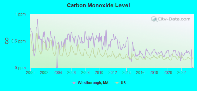
Carbon Monoxide (CO) [ppm] level in 2022 was 0.259. This is about average.Closest monitor was 9.1 miles away from the city center.
City:
0.259
U.S.:
0.251
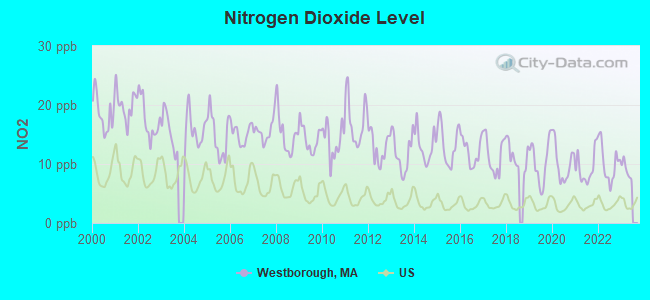
Nitrogen Dioxide (NO2) [ppb] level in 2022 was 10.1. This is significantly worse than average.Closest monitor was 7.3 miles away from the city center.
City:
10.1
U.S.:
5.1
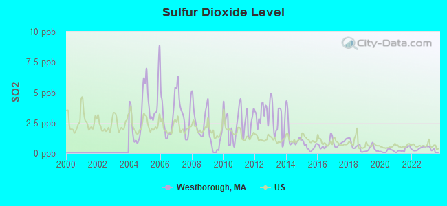
Sulfur Dioxide (SO2) [ppb] level in 2022 was 0.370. This is significantly better than average.Closest monitor was 7.3 miles away from the city center.
City:
0.370
U.S.:
1.515
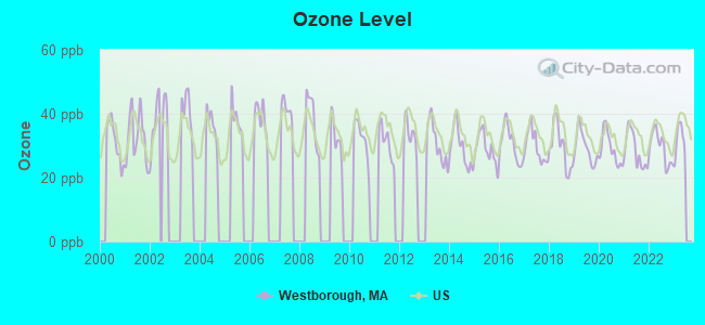
Ozone [ppb] level in 2022 was 29.4. This is about average.Closest monitor was 7.3 miles away from the city center.
City:
29.4
U.S.:
33.3
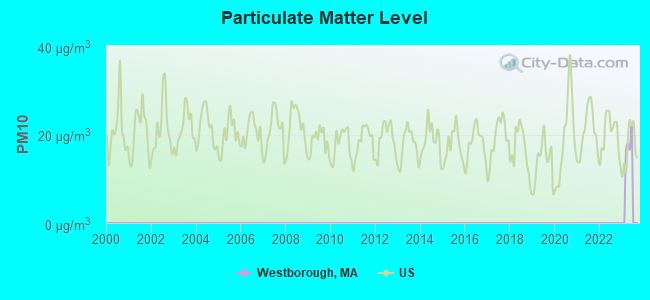
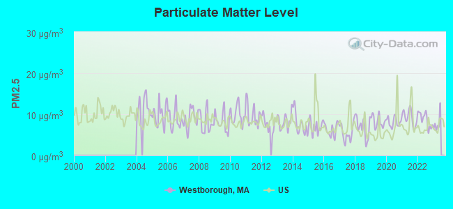
Particulate Matter (PM2.5) [µg/m3] level in 2022 was 8.71. This is about average.Closest monitor was 9.1 miles away from the city center.
City:
8.71
U.S.:
8.11
Tornado activity:
Westborough-area historical tornado activity is slightly above Massachusetts state average. It is 26% smaller than the overall U.S. average.
On 6/9/1953, a category F4 (max. wind speeds 207-260 mph) tornado 5.4 miles away from the Westborough place center killed 90 peopleand injured 1228 peopleand causedbetween $50,000,000 and $500,000,000 in damages.
On 6/9/1953, a category F3 (max. wind speeds 158-206 mph) tornado 10.4 miles away from the place center injured 17 peopleand causedbetween $500,000 and $5,000,000 in damages.
Earthquake activity:
Westborough-area historical earthquake activity is significantly above Massachusetts state average. It is 72% smaller than the overall U.S. average.
On 10/7/1983 at 10:18:46, a magnitude 5.3 (5.1 MB, 5.3 LG, 5.1 ML, Class: Moderate, Intensity: VI - VII) earthquake occurred 180.2 miles away from Westborough center On 4/20/2002 at 10:50:47, a magnitude 5.3 (5.3 ML, Depth: 3.0 mi) earthquake occurred 187.1 miles away from Westborough center On 4/20/2002 at 10:50:47, a magnitude 5.2 (5.2 MB, 4.2 MS, 5.2 MW, 5.0 MW) earthquake occurred 186.2 miles away from the city center On 1/19/1982 at 00:14:42, a magnitude 4.7 (4.5 MB, 4.7 MD, 4.5 LG, Class: Light, Intensity: IV - V) earthquake occurred 85.1 miles away from Westborough center On 10/16/2012 at 23:12:25, a magnitude 4.7 (4.7 ML, Depth: 10.0 mi) earthquake occurred 103.9 miles away from Westborough center On 8/22/1992 at 12:20:32, a magnitude 4.8 (4.8 MB, 3.8 MS, 4.7 LG, Depth: 6.2 mi) earthquake occurred 229.2 miles away from Westborough center Magnitude types: regional Lg-wave magnitude (LG), body-wave magnitude (MB), duration magnitude (MD), local magnitude (ML), surface-wave magnitude (MS), moment magnitude (MW)
Natural disasters:
The number of natural disasters in Worcester County (27) is a lot greater than the US average (15). Major Disasters (Presidential) Declared: 15 Emergencies Declared: 12
Causes of natural disasters: Floods: 9, Storms: 8, Hurricanes: 6, Snowstorms: 5, Winter Storms: 4, Blizzards: 2, Snows: 2, Fire: 1, Heavy Rain: 1, Snowfall: 1, Tornado: 1, Wind: 1 (Note: some incidents may be assigned to more than one category).
Main business address for: APPLIX INC /MA/ (SERVICES-PREPACKAGED SOFTWARE), TC PIPELINES LP (NATURAL GAS TRANSMISSION), ARCH WIRELESS INC (RADIO TELEPHONE COMMUNICATIONS), NEW ENGLAND POWER CO (ELECTRIC SERVICES), AMERICAN SUPERCONDUCTOR CORP /DE/ (MOTORS & GENERATORS), SWITCHBOARD INC (SERVICES-BUSINESS SERVICES, NEC), ASCENTIAL SOFTWARE CORP (SERVICES-PREPACKAGED SOFTWARE).
Hospitals and medical centers in Westborough:
WESTBOROUGH STATE HOSP (LYMAN ST)
WESTBOROUGH STATE HOSPTIAL (LYMAN STREET (DANIELS BLDG))
WESTBOROUGH PUBLIC LIBRARY (Operating income: $853,201; Location: 55 WEST MAIN ST.; 79,690 books; 930 e-books; 5,964 audio materials; 3,638 video materials; 3 local licensed databases; 34 state licensed databases; 171 print serial subscriptions)
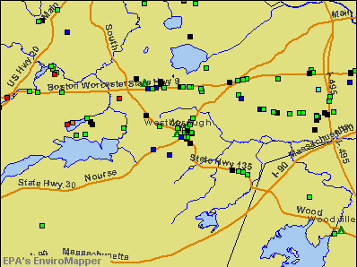
Notable locations in Westborough: Westborough Country Club (A), Westboro Country Club (B), Westborough Fire Department (C), Westborough High School Media Center (D), Westborough Town Hall (E), Westborough Public Library (F). Display/hide their locations on the map
Churches in Westborough include: Unitarin Church of Westboro (A), Saint Stephens Episcopal Church (B), Saint Lukes Church (C), First United Methodist Church (D), First Baptist Church of Westboro (E), Evangelical Congregational Church (F). Display/hide their locations on the map
Tourist attractions: New England Winter Sports Representatives Inc (Amusement & Theme Parks; 21 South Street Suite 3), Kentshane Adventures (3 Ruggles Street).
Hotels: Extended Stayamerica (19 Connector Road), Comfort Inn (Bos Worc Turnpike), Esa - Boston/Westborough (19 Connector Rd), Sierra Suites Hotel (1800 Computer Drive), Ramada Inn Westboro (39 Beeton Path).
Courts: Westboro Court Maintenance Department (175 Milk Street), Westborough District Court Jury Session (175 Milk Street), Worcester County - District Courts- Westboro District Court (175 Milk Street).
Birthplace of: Horace Maynard - Politician, Eli Whitney - (1765-1825), cotton gin, interchangeable parts, Henry W. Corbett - Politician, John Ruggles - Politician, Louis E. Denfeld - Soilder, Chris Banks (soccer) - Soccer player, Esther Forbes.
Worcester County has a predicted average indoor radon screening level greater than 4 pCi/L (pico curies per liter) - Highest Potential
Drinking water stations with addresses in Westborough and their reported violations in the past:
WESTBOROUGH WATER DEPARTMENT (Population served: 18,272, Surface water):
Past health violations:
MCL, Acute (TCR) - In AUG-2013, Contaminant: Coliform. Follow-up actions: St AO (w/o penalty) issued (OCT-23-2013), St Compliance achieved (OCT-23-2013)
MCL, Monthly (TCR) - In AUG-2013, Contaminant: Coliform. Follow-up actions: St AO (w/o penalty) issued (OCT-23-2013), St Compliance achieved (OCT-23-2013)
MCL, Monthly (TCR) - In JUN-2013, Contaminant: Coliform. Follow-up actions: St AO (w/o penalty) issued (AUG-07-2013), St Compliance achieved (AUG-07-2013)
Treatment Technique (SWTR and GWR) - In MAR-2008. Follow-up actions: St AO (w/o penalty) issued (JUN-09-2008)
Past monitoring violations:
Monitoring and Reporting (DBP) - Between APR-2009 and JUN-2009, Contaminant: Chlorine. Follow-up actions: St AO (w/o penalty) issued (SEP-03-2009), St Compliance achieved (SEP-03-2009)
Monitoring of Treatment (SWTR-Filter) - In MAR-2008. Follow-up actions: St AO (w/o penalty) issued (JUN-09-2008)
One minor monitoring violation
9 regular monitoring violations
ESTATES AT HIGHLAND RIDGE (Population served: 100, Groundwater):
Past health violations:
MCL, Monthly (TCR) - In OCT-2010, Contaminant: Coliform. Follow-up actions: St AO (w/o penalty) issued (NOV-12-2010), St Compliance achieved (NOV-12-2010)
Past monitoring violations:
Follow-up Or Routine LCR Tap M/R - In OCT-01-2005, Contaminant: Lead and Copper Rule. Follow-up actions: St AO (w/o penalty) issued (FEB-17-2006), St Compliance achieved (FEB-05-2007)
37 regular monitoring violations
VILLAGES AT STOW (Address: 33 LYMAN STREET, SUITE 210 , Population served: 60, Groundwater):
Past health violations:
MCL, Monthly (TCR) - In AUG-2014, Contaminant: Coliform. Follow-up actions: St AO (w/o penalty) issued (AUG-19-2014)
Past monitoring violations:
5 minor monitoring violations
102 regular monitoring violations
CHARLTON MANOR REST HOME (Address: 1 GALE MEADOW WAY , Population served: 26, Groundwater):
Past health violations:
MCL, Average - Between JAN-2007 and MAR-2007, Contaminant: Arsenic. Follow-up actions: St AO (w/o penalty) issued (APR-12-2007), St Compliance achieved (APR-25-2007)
MCL, Average - Between OCT-2006 and DEC-2006, Contaminant: Arsenic. Follow-up actions: St AO (w/o penalty) issued (NOV-14-2006)
Average household size:
This place:
2.2 people
Massachusetts:
2.5 people
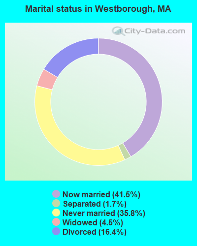
Percentage of family households:
This place:
56.4%
Whole state:
63.0%
Percentage of households with unmarried partners:
This place:
5.8%
Whole state:
7.0%
Likely homosexual households (counted as self-reported same-sex unmarried-partner households)
Lesbian couples: 0.6% of all households
Gay men: 0.1% of all households
People in group quarters in Westborough in 2010:
116 people in nursing facilities/skilled-nursing facilities
10 people in residential treatment centers for juveniles (non-correctional)
5 people in group homes intended for adults
2 people in other noninstitutional facilities
159 people in nursing homes in 2000
2 people in other nonhousehold living situations in 2000
Banks with most branches in Westborough (2011 data):
Avidia Bank: West Main Branch, Willows Branch, Westborough Savings Bank Branch. Info updated 2010/01/04: Bank assets: $1,026.2 mil, Deposits: $801.2 mil, headquarters in Hudson, MA, positive income, Commercial Lending Specialization, 10 total offices, Holding Company: Assabet Valley Bancorp
RBS Citizens, National Association: Westborough Stop & Shop Branch at 290 Turnpike Road, Route 9, branch established on 2002/09/18; Westborough Stop & Shop Branch at 32 Lyman Street, branch established on 2001/12/22. Info updated 2007/09/19: Bank assets: $106,940.6 mil, Deposits: $75,690.2 mil, headquarters in Providence, RI, positive income, 1135 total offices, Holding Company: Uk Financial Investments Limited
Bank of America, National Association: Lyman Street Branch at 35 Lyman Street, branch established on 1982/10/18; Speedway Plaza Branch at 306 Turnpine Road, branch established on 2002/09/30. Info updated 2009/11/18: Bank assets: $1,451,969.3 mil, Deposits: $1,077,176.8 mil, headquarters in Charlotte, NC, positive income, 5782 total offices, Holding Company: Bank Of America Corporation
Middlesex Savings Bank: Home/Phone Banking Branch Informatio at 120 Flanders Rd, branch established on 2000/06/22. Info updated 2009/07/16: Bank assets: $4,034.8 mil, Deposits: $3,490.0 mil, headquarters in Natick, MA, positive income, Mortgage Lending Specialization, 33 total offices, Holding Company: Middlesex Bancorp Mhc
People's United Bank: Westborough Branch at 8 Lyman Street, branch established on 2005/04/25. Info updated 2012/02/16: Bank assets: $27,319.3 mil, Deposits: $20,835.4 mil, headquarters in Bridgeport, CT, positive income, Commercial Lending Specialization, 374 total offices
Sovereign Bank, National Association: Westborough Branch at 70 East Main Street, branch established on 1965/08/16. Info updated 2012/01/31: Bank assets: $78,146.9 mil, Deposits: $48,042.9 mil, headquarters in Wilmington, DE, positive income, Commercial Lending Specialization, 718 total offices, Holding Company: Banco Santander, S.A.
TD Bank, National Association: Bay State Commons Branch at 800 Union Street, branch established on 1987/01/01. Info updated 2010/10/04: Bank assets: $188,912.6 mil, Deposits: $153,149.8 mil, headquarters in Wilmington, DE, positive income, 1314 total offices, Holding Company: Toronto-Dominion Bank, The
Commerce Bank & Trust Company: Westborough Branch at 5 East Main, branch established on 1985/10/03. Info updated 2006/10/06: Bank assets: $1,410.8 mil, Deposits: $1,187.6 mil, headquarters in Worcester, MA, positive income, Commercial Lending Specialization, 14 total offices, Holding Company: Commerce Bancshares Corp.
Marlborough Savings Bank: Westborough Branch at 21 East Main Street, branch established on 2008/03/17. Info updated 2010/10/21: Bank assets: $446.2 mil, Deposits: $367.7 mil, headquarters in Marlborough, MA, positive income, 6 total offices, Holding Company: Marlborough Bancshares Mhc
Religion statistics for Westborough, MA (based on Worcester County data)
Religion
Adherents
Congregations
Catholic
306,925
118
Mainline Protestant
43,326
171
Evangelical Protestant
37,511
203
Other
18,931
69
Orthodox
7,935
15
Black Protestant
497
6
None
383,427
-
Source: Clifford Grammich, Kirk Hadaway, Richard Houseal, Dale E.Jones, Alexei Krindatch, Richie Stanley and Richard H.Taylor. 2012. 2010 U.S.Religion Census: Religious Congregations & Membership Study. Association of Statisticians of American Religious Bodies. Jones, Dale E., et al. 2002. Congregations and Membership in the United States 2000. Nashville, TN: Glenmary Research Center. Graphs represent county-level data
Aircraft: BELLANCA 8KCAB (Category: Land, Seats: 2, Weight: Up to 12,499 Pounds, Speed: 101 mph), Engine: LYCOMING AEIO-360 SER (180 HP) (Reciprocating) N-Number: 5062D, N5062D, N-5062D, Serial Number: 566-79, Year manufactured: 1979, Airworthiness Date: 09/29/1979, Certificate Issue Date: 02/24/2005 Registrant (Individual): Guy C Roberge, 30 Upton Rd, Westborough, MA 01581
Aircraft: PIPER PA-28-235 (Category: Land, Seats: 4, Weight: Up to 12,499 Pounds, Speed: 107 mph), Engine: LYCOMING 0-540 SERIES (250 HP) (Reciprocating) N-Number: 55007, N55007, N-55007, Serial Number: 28-7310106, Year manufactured: 1973, Airworthiness Date: 02/18/1991, Certificate Issue Date: 10/05/1994 Registrant (Corporation): Av8 Inc, 4 Cabot Cir, Westborough, MA 01581
Aircraft: CESSNA R182 (Category: Land, Seats: 4, Weight: Up to 12,499 Pounds, Speed: 111 mph), Engine: LYCOMING 0-540 SERIES (250 HP) (Reciprocating) N-Number: 737HP, N737HP, N-737HP, Serial Number: R18200830, Year manufactured: 1979, Airworthiness Date: 02/19/1979, Certificate Issue Date: 11/14/2008 Registrant (Individual): Anthony B Linn, 10 Mohawk Dr, Westborough, MA 01581
Aircraft: BEECH F33A (Category: Land, Seats: 5, Weight: Up to 12,499 Pounds, Speed: 138 mph), Engine: CONT MOTOR IO 520 SERIES (285 HP) (Reciprocating) N-Number: 9351Q, N9351Q, N-9351Q, Serial Number: CE-351, Year manufactured: 1971, Airworthiness Date: 09/27/1971, Certificate Issue Date: 03/26/2019 Registrant (Individual): Steven M Bolduc, 6 Chestnut St, Westborough, MA 01581
Aircraft: BEECH V35B (Category: Land, Seats: 6, Weight: Up to 12,499 Pounds, Speed: 150 mph), Engine: CONT MOTOR IO 520 SERIES (285 HP) (Reciprocating) N-Number: 9440Q, N9440Q, N-9440Q, Serial Number: D-9319, Year manufactured: 1972, Airworthiness Date: 02/11/1972, Certificate Issue Date: 10/14/2009 Registrant (Partnership): Andrew U Reinach, 5 Nipmuck Dr, Westborough, MA 01581, Other Owners: Alan E Katz
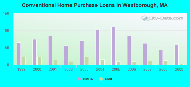
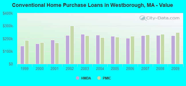
Home Mortgage Disclosure Act Aggregated Statistics For Year 2009 (Based on 1 full tract)
A) FHA, FSA/RHS & VA Home Purchase Loans
B) Conventional Home Purchase Loans
C) Refinancings
D) Home Improvement Loans
E) Loans on Dwellings For 5+ Families
F) Non-occupant Loans on < 5 Family Dwellings (A B C & D)
Number
Average Value
Number
Average Value
Number
Average Value
Number
Average Value
Number
Average Value
Number
Average Value
LOANS ORIGINATED
12
$265,000
58
$223,448
103
$255,000
8
$182,375
1
$2,257,000
13
$203,462
APPLICATIONS APPROVED, NOT ACCEPTED
0
$0
6
$227,667
17
$256,412
1
$5,000
0
$0
1
$446,000
APPLICATIONS DENIED
3
$207,667
8
$161,375
34
$253,706
1
$1,000
0
$0
1
$143,000
APPLICATIONS WITHDRAWN
2
$222,500
3
$319,333
23
$232,957
1
$20,000
0
$0
0
$0
FILES CLOSED FOR INCOMPLETENESS
1
$330,000
1
$298,000
5
$285,400
1
$25,000
0
$0
0
$0
Aggregated Statistics For Year 2008 (Based on 1 full tract)
A) FHA, FSA/RHS & VA Home Purchase Loans
B) Conventional Home Purchase Loans
C) Refinancings
D) Home Improvement Loans
E) Loans on Dwellings For 5+ Families
F) Non-occupant Loans on < 5 Family Dwellings (A B C & D)
Number
Average Value
Number
Average Value
Number
Average Value
Number
Average Value
Number
Average Value
Number
Average Value
LOANS ORIGINATED
5
$288,600
43
$225,535
46
$269,304
4
$190,250
1
$511,000
6
$290,333
APPLICATIONS APPROVED, NOT ACCEPTED
0
$0
5
$260,800
7
$266,857
0
$0
0
$0
3
$169,333
APPLICATIONS DENIED
3
$274,667
10
$182,200
13
$226,385
1
$168,000
0
$0
4
$249,000
APPLICATIONS WITHDRAWN
2
$302,000
5
$404,800
7
$314,714
0
$0
0
$0
1
$304,000
FILES CLOSED FOR INCOMPLETENESS
0
$0
3
$237,333
2
$204,500
0
$0
0
$0
0
$0
Aggregated Statistics For Year 2007 (Based on 1 full tract)
A) FHA, FSA/RHS & VA Home Purchase Loans
B) Conventional Home Purchase Loans
C) Refinancings
D) Home Improvement Loans
E) Loans on Dwellings For 5+ Families
F) Non-occupant Loans on < 5 Family Dwellings (A B C & D)
Number
Average Value
Number
Average Value
Number
Average Value
Number
Average Value
Number
Average Value
Number
Average Value
LOANS ORIGINATED
1
$280,000
63
$224,190
61
$227,344
13
$119,231
1
$270,000
15
$218,600
APPLICATIONS APPROVED, NOT ACCEPTED
0
$0
10
$161,700
9
$294,778
2
$86,000
0
$0
1
$270,000
APPLICATIONS DENIED
0
$0
9
$220,556
32
$238,938
2
$55,000
1
$275,000
4
$122,250
APPLICATIONS WITHDRAWN
1
$261,000
2
$209,000
17
$297,412
2
$50,000
0
$0
1
$270,000
FILES CLOSED FOR INCOMPLETENESS
0
$0
2
$235,500
7
$234,857
0
$0
0
$0
2
$373,500
Aggregated Statistics For Year 2006 (Based on 1 full tract)
B) Conventional Home Purchase Loans
C) Refinancings
D) Home Improvement Loans
E) Loans on Dwellings For 5+ Families
F) Non-occupant Loans on < 5 Family Dwellings (A B C & D)
Number
Average Value
Number
Average Value
Number
Average Value
Number
Average Value
Number
Average Value
LOANS ORIGINATED
84
$202,881
93
$202,237
22
$106,955
3
$946,000
22
$180,591
APPLICATIONS APPROVED, NOT ACCEPTED
10
$222,900
7
$104,714
3
$41,667
0
$0
0
$0
APPLICATIONS DENIED
9
$237,222
49
$282,816
11
$121,273
0
$0
4
$201,000
APPLICATIONS WITHDRAWN
5
$268,800
32
$246,594
2
$200,500
0
$0
1
$200,000
FILES CLOSED FOR INCOMPLETENESS
1
$185,000
18
$264,111
3
$68,333
0
$0
0
$0
Aggregated Statistics For Year 2005 (Based on 1 full tract)
A) FHA, FSA/RHS & VA Home Purchase Loans
B) Conventional Home Purchase Loans
C) Refinancings
D) Home Improvement Loans
E) Loans on Dwellings For 5+ Families
F) Non-occupant Loans on < 5 Family Dwellings (A B C & D)
G) Loans On Manufactured Home Dwelling (A B C & D)
Number
Average Value
Number
Average Value
Number
Average Value
Number
Average Value
Number
Average Value
Number
Average Value
Number
Average Value
LOANS ORIGINATED
4
$205,000
111
$218,649
113
$239,504
17
$122,706
2
$195,000
21
$241,238
1
$29,000
APPLICATIONS APPROVED, NOT ACCEPTED
0
$0
16
$300,688
8
$198,625
2
$33,000
0
$0
0
$0
1
$50,000
APPLICATIONS DENIED
0
$0
25
$240,400
19
$210,053
5
$139,600
0
$0
0
$0
0
$0
APPLICATIONS WITHDRAWN
0
$0
18
$274,500
26
$208,000
2
$385,500
0
$0
3
$206,333
0
$0
FILES CLOSED FOR INCOMPLETENESS
0
$0
7
$160,286
20
$262,650
0
$0
0
$0
3
$385,000
0
$0
Aggregated Statistics For Year 2004 (Based on 1 full tract)
A) FHA, FSA/RHS & VA Home Purchase Loans
B) Conventional Home Purchase Loans
C) Refinancings
D) Home Improvement Loans
E) Loans on Dwellings For 5+ Families
F) Non-occupant Loans on < 5 Family Dwellings (A B C & D)
Number
Average Value
Number
Average Value
Number
Average Value
Number
Average Value
Number
Average Value
Number
Average Value
LOANS ORIGINATED
0
$0
102
$227,961
109
$210,853
10
$147,000
1
$620,000
17
$233,059
APPLICATIONS APPROVED, NOT ACCEPTED
0
$0
16
$196,875
9
$225,222
3
$70,000
0
$0
1
$150,000
APPLICATIONS DENIED
0
$0
10
$172,400
29
$211,379
5
$44,600
0
$0
5
$186,000
APPLICATIONS WITHDRAWN
1
$128,000
11
$225,545
25
$202,520
0
$0
0
$0
5
$287,000
FILES CLOSED FOR INCOMPLETENESS
0
$0
2
$210,000
16
$217,938
1
$31,000
0
$0
0
$0
Aggregated Statistics For Year 2003 (Based on 1 full tract)
A) FHA, FSA/RHS & VA Home Purchase Loans
B) Conventional Home Purchase Loans
C) Refinancings
D) Home Improvement Loans
E) Loans on Dwellings For 5+ Families
F) Non-occupant Loans on < 5 Family Dwellings (A B C & D)
Number
Average Value
Number
Average Value
Number
Average Value
Number
Average Value
Number
Average Value
Number
Average Value
LOANS ORIGINATED
2
$296,000
70
$234,586
318
$195,116
9
$62,556
5
$369,200
15
$224,200
APPLICATIONS APPROVED, NOT ACCEPTED
1
$226,000
5
$229,600
32
$198,969
4
$69,000
0
$0
0
$0
APPLICATIONS DENIED
1
$367,000
12
$249,083
54
$185,926
1
$40,000
0
$0
0
$0
APPLICATIONS WITHDRAWN
0
$0
7
$195,000
34
$176,529
1
$11,000
0
$0
2
$167,000
FILES CLOSED FOR INCOMPLETENESS
0
$0
4
$226,500
5
$156,000
0
$0
0
$0
0
$0
Aggregated Statistics For Year 2002 (Based on 1 full tract)
A) FHA, FSA/RHS & VA Home Purchase Loans
B) Conventional Home Purchase Loans
C) Refinancings
D) Home Improvement Loans
E) Loans on Dwellings For 5+ Families
F) Non-occupant Loans on < 5 Family Dwellings (A B C & D)
Number
Average Value
Number
Average Value
Number
Average Value
Number
Average Value
Number
Average Value
Number
Average Value
LOANS ORIGINATED
3
$243,333
56
$224,911
242
$189,665
12
$70,833
1
$150,000
16
$203,188
APPLICATIONS APPROVED, NOT ACCEPTED
0
$0
6
$209,500
28
$174,321
5
$39,600
0
$0
3
$181,333
APPLICATIONS DENIED
0
$0
2
$230,000
26
$199,000
6
$156,500
0
$0
5
$184,600
APPLICATIONS WITHDRAWN
0
$0
7
$213,571
26
$141,077
0
$0
0
$0
1
$326,000
FILES CLOSED FOR INCOMPLETENESS
0
$0
0
$0
6
$238,833
0
$0
0
$0
0
$0
Aggregated Statistics For Year 2001 (Based on 1 full tract)
A) FHA, FSA/RHS & VA Home Purchase Loans
B) Conventional Home Purchase Loans
C) Refinancings
D) Home Improvement Loans
E) Loans on Dwellings For 5+ Families
F) Non-occupant Loans on < 5 Family Dwellings (A B C & D)
Number
Average Value
Number
Average Value
Number
Average Value
Number
Average Value
Number
Average Value
Number
Average Value
LOANS ORIGINATED
8
$171,375
85
$190,365
182
$167,280
10
$30,700
1
$135,000
14
$153,071
APPLICATIONS APPROVED, NOT ACCEPTED
0
$0
9
$237,000
17
$134,824
9
$22,111
0
$0
1
$160,000
APPLICATIONS DENIED
0
$0
8
$152,750
23
$147,435
6
$34,167
0
$0
0
$0
APPLICATIONS WITHDRAWN
1
$172,000
8
$152,250
20
$133,650
5
$28,000
0
$0
1
$97,000
FILES CLOSED FOR INCOMPLETENESS
0
$0
2
$186,000
4
$176,750
0
$0
0
$0
1
$238,000
Aggregated Statistics For Year 2000 (Based on 1 full tract)
A) FHA, FSA/RHS & VA Home Purchase Loans
B) Conventional Home Purchase Loans
C) Refinancings
D) Home Improvement Loans
E) Loans on Dwellings For 5+ Families
F) Non-occupant Loans on < 5 Family Dwellings (A B C & D)
Number
Average Value
Number
Average Value
Number
Average Value
Number
Average Value
Number
Average Value
Number
Average Value
LOANS ORIGINATED
6
$170,833
75
$161,227
38
$115,500
16
$26,312
1
$33,000
7
$215,143
APPLICATIONS APPROVED, NOT ACCEPTED
1
$82,000
8
$126,250
6
$52,333
2
$9,500
0
$0
0
$0
APPLICATIONS DENIED
0
$0
5
$285,200
6
$122,667
6
$37,167
0
$0
0
$0
APPLICATIONS WITHDRAWN
0
$0
3
$127,000
11
$88,182
0
$0
0
$0
1
$56,000
FILES CLOSED FOR INCOMPLETENESS
0
$0
0
$0
0
$0
0
$0
0
$0
0
$0
Aggregated Statistics For Year 1999 (Based on 1 full tract)
A) FHA, FSA/RHS & VA Home Purchase Loans
B) Conventional Home Purchase Loans
C) Refinancings
D) Home Improvement Loans
E) Loans on Dwellings For 5+ Families
F) Non-occupant Loans on < 5 Family Dwellings (A B C & D)
Detailed PMIC statistics for the following Tracts:7423.00
2002 - 2018 National Fire Incident Reporting System (NFIRS) incidents
Based on the data from the years 2002 - 2018 the average number of fires per year is 95. The highest number of fires - 154 took place in 2017, and the least - 54 in 2013. The data has a rising trend.
When looking into fire subcategories, the most reports belonged to: Structure Fires (58.7%), and Outside Fires (28.1%).
Fire incident types reported to NFIRS in Westborough, MA
Extended Stay America - Boston - Westborough - East Main Street, 180 E Main St, Westborough, Massachusetts 01581 , Phone: (508) 616-9213, Fax: (508) 616-9214


 Recent articles from our blog. Our writers, many of them Ph.D. graduates or candidates, create easy-to-read articles on a wide variety of topics.

 (9.5 miles


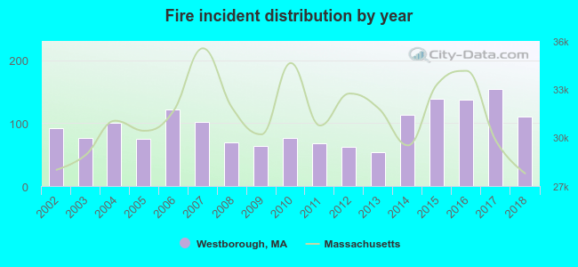 Based on the data from the years 2002 - 2018 the average number of fires per year is 95. The highest number of fires - 154 took place in 2017, and the least - 54 in 2013. The data has a rising trend.
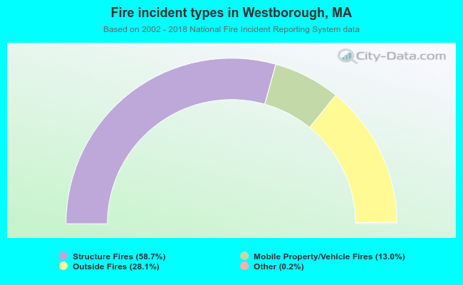 When looking into fire subcategories, the most reports belonged to: Structure Fires (58.7%), and Outside Fires (28.1%).