Bridge Statistics for Wheat Ridge, Colorado (CO)
Condition, Traffic, Stress, Structural Evaluation, Project Costs
- National Bridge Inventory (NBI) Statistics
- 48Number of bridges
- 719ft / 219mTotal length
- $12,711,000Total costs
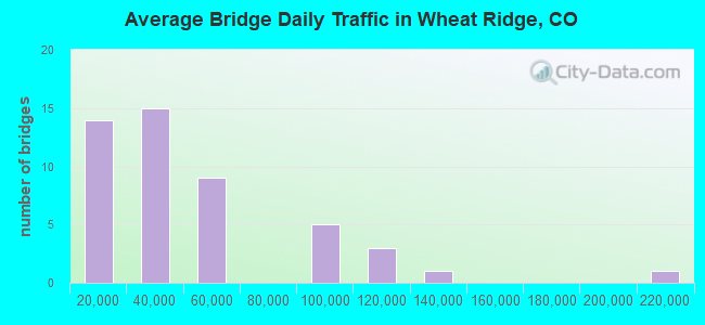
- 2,215,402Total average daily traffic
- 171,324Total average daily truck traffic
- National Bridge Inventory (NBI) Registered Bridges for Wheat Ridge
- No street view available for this location
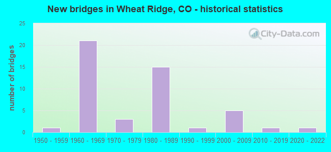
- New bridges - historical statistics
- 11950-1959
- 211960-1969
- 31970-1979
- 151980-1989
- 11990-1999
- 52000-2009
- 12010-2019
- 12020-2022
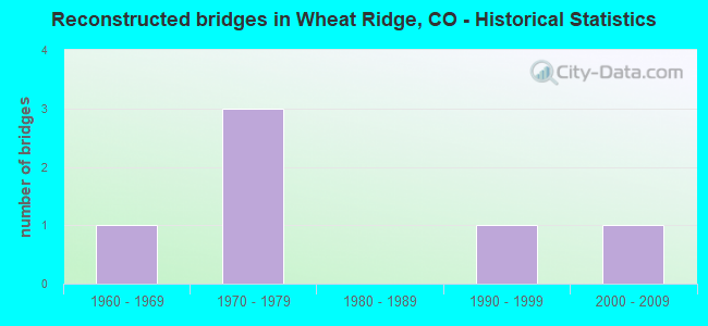
- Reconstructed bridges - Historical Statistics
- 11960-1969
- 31970-1979
- 01980-1989
- 11990-1999
- 12000-2009
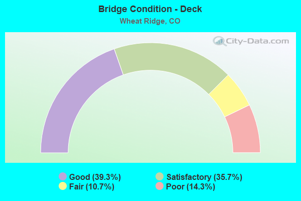
- Bridge Condition - Deck
- 39.3%Good
- 35.7%Satisfactory
- 10.7%Fair
- 14.3%Poor
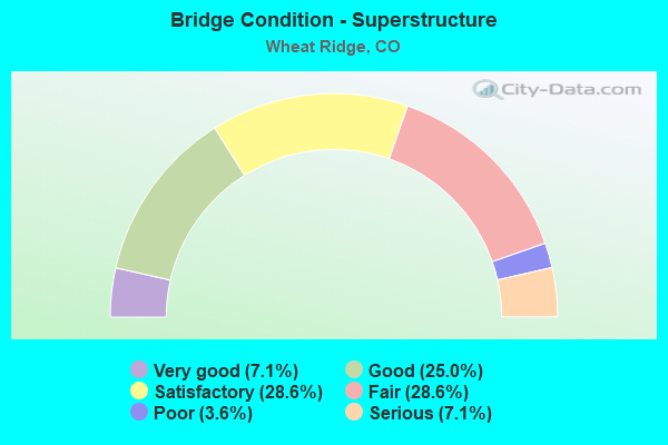
- Bridge Condition - Superstructure
- 7.1%Very good
- 25.0%Good
- 28.6%Satisfactory
- 28.6%Fair
- 3.6%Poor
- 7.1%Serious
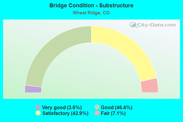
- Bridge Condition - Substructure
- 3.6%Very good
- 46.4%Good
- 42.9%Satisfactory
- 7.1%Fair

- Bridge Condition - Channel
- 50.0%Very good
- 22.2%Good
- 27.8%Satisfactory
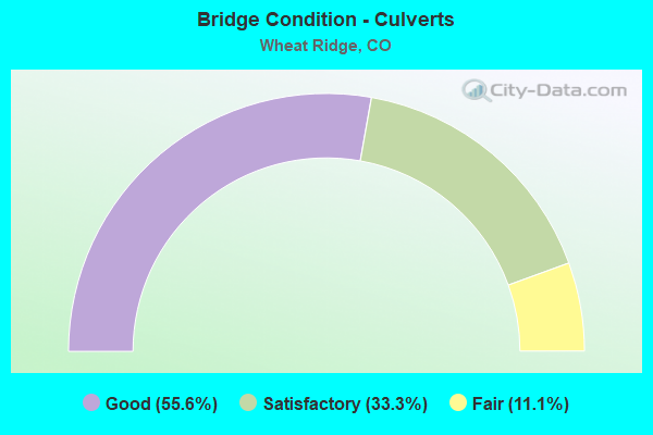
- Bridge Condition - Culverts
- 55.6%Good
- 33.3%Satisfactory
- 11.1%Fair
Find on map >> Show street view
Structure Number: E-16-JN, Location: WHEATRIDGE (Lat: 39.779397, Lng: -105.138186), Route carried "under" structure: State highway 72A, Year Built: 1968, Structure Length: 0. m, Average Daily Traffic: 34,000 (year 2011), Truck Traffic: 5%, Features Intersected: SH 72 ML, Facility Carried by Structure: I 70 ML EBND
Minimum Vertical Clearance: 5.92m (19.42ft), Kilometerpoint: 0.002, Lanes on structure: 4, Lanes under structure: 6, Material/Design: Concrete continuous, Design/Construction: Box Beam or Girders - Multiple, Length of Maximum Span: 23.2m (76.1ft)
Find on map >> Show street view
Structure Number: E-16-JX, Location: IN ARVADA (Lat: 39.786625, Lng: -105.073386), Route carried "under" structure: Interstate 70A, Year Built: 1982, Structure Length: 0. m, Average Daily Traffic: 90,000 (year 2011), Truck Traffic: 6%, Features Intersected: I 70 ML WBND, Facility Carried by Structure: I 76 ML EBND
Minimum Vertical Clearance: 5.74m (18.83ft), Kilometerpoint: 433.400, Lanes on structure: 4, Lanes under structure: 3, Material/Design: Steel, Design/Construction: Box Beam or Girders - Single/Spread, Length of Maximum Span: 55.4m (181.8ft)
Find on map >> Show street view
Structure Number: E-16-JY, Location: I70, I76, SH121 INTERCHAN (Lat: 39.786200, Lng: -105.075200), Route carried "under" structure: Interstate 70A, Year Built: 1982, Structure Length: 0. m, Average Daily Traffic: 90,000 (year 2011), Truck Traffic: 6%, Features Intersected: I 70 ML EBND, Facility Carried by Structure: RAMP TO I 76 EBND
Minimum Vertical Clearance: 5.79m (19.00ft), Kilometerpoint: 433.373, Lanes on structure: 2, Lanes under structure: 3, Material/Design: Steel, Design/Construction: Box Beam or Girders - Single/Spread, Length of Maximum Span: 60.9m (199.8ft)
Find on map >> Show street view
Structure Number: E-16-RS, Location: I-70 & SH 58 INTERCHA (Lat: 39.772853, Lng: -105.142756), Route carried "under" structure: Spur State highway 58A, Year Built: 2008, Structure Length: 0. m, Average Daily Traffic: 27,300 (year 2005), Truck Traffic: 14%, Features Intersected: I70ML/ SH58 ML/CLR CRK, Facility Carried by Structure: SH 58 RAMP
Minimum Vertical Clearance: 5.16m (16.93ft), Kilometerpoint: 8.752, Lanes on structure: 1, Lanes under structure: 2, Material/Design: Prestressed concrete continuous, Design/Construction: Box Beam or Girders - Single/Spread, Length of Maximum Span: 71.6m (234.9ft)
Find on map >> Show street view
Structure Number: E-16-RS, Location: I-70 & SH 58 INTERCHA (Lat: 39.772853, Lng: -105.142756), Route carried "under" structure: Interstate 70A, Year Built: 2008, Structure Length: 0. m, Average Daily Traffic: 104,000 (year 2008), Truck Traffic: 10%, Features Intersected: I70ML/ SH58 ML/CLR CRK, Facility Carried by Structure: SH 58 RAMP
Minimum Vertical Clearance: 5.77m (18.93ft), Kilometerpoint: 427.039, Lanes on structure: 1, Lanes under structure: 6, Material/Design: Prestressed concrete continuous, Design/Construction: Box Beam or Girders - Single/Spread, Length of Maximum Span: 71.6m (234.9ft)