Bridge Statistics for White House Station, New Jersey (NJ)
Condition, Traffic, Stress, Structural Evaluation, Project Costs
- National Bridge Inventory (NBI) Statistics
- 47Number of bridges
- 295ft / 89.5mTotal length
- $11,330,000Total costs
- 1,081,598Total average daily traffic
- 107,669Total average daily truck traffic
- National Bridge Inventory (NBI) Registered Bridges for White House Station
- No street view available for this location
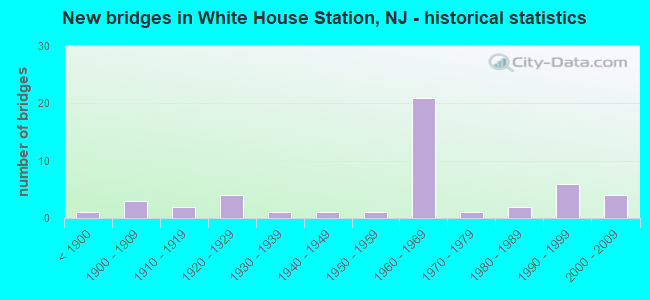
- New bridges - historical statistics
- 1Before 1900
- 31900-1909
- 21910-1919
- 41920-1929
- 11930-1939
- 11940-1949
- 11950-1959
- 211960-1969
- 11970-1979
- 21980-1989
- 61990-1999
- 42000-2009

- Reconstructed bridges - Historical Statistics
- 11960-1969
- 31970-1979
- 41980-1989
- 21990-1999
- 22000-2009
- 32010-2019
- 12020-2022


- Bridge Condition - Deck
- 2.8%Excellent
- 8.3%Very good
- 22.2%Good
- 58.3%Satisfactory
- 8.3%Fair

- Bridge Condition - Superstructure
- 2.8%Excellent
- 11.1%Very good
- 47.2%Good
- 27.8%Satisfactory
- 8.3%Fair
- 2.8%Poor

- Bridge Condition - Substructure
- 5.6%Very good
- 44.4%Good
- 33.3%Satisfactory
- 16.7%Fair

- Bridge Condition - Channel
- 3.6%Very good
- 17.9%Good
- 50.0%Satisfactory
- 28.6%Fair
Find on map >> Show street view
Structure Number: 1000015, Location: @ INTERSECT. WITH CR 629 (Lat: 40.569611, Lng: -74.813639), Route carried "on" structure: County highway 523, Year Built: 1994, Status: Open, Structure Length: 0.61m (2.00ft), Average Daily Traffic: 9,808 (year 2021), Truck Traffic: 4%, Average Future Daily Traffic: 11,770 (year 2041), Design Load: HS 25 or greater, Features Intersected: PLEASANT RUN
Minimum Vertical Clearance: 30+ m (98+ ft), Kilometerpoint: 25.460, Lanes on structure: 2, Base Highway Network: Yes, Owner: County Highway Agency, Approaching Roadway Width: 13.1m (43.0ft), Material/Design: Concrete, Design/Construction: Culvert, Number Of Spans In Main Unit: 1, Length of Maximum Span: 6.1m (20.0ft)
Condition: Channel: Good, Culverts: Satisfactory, Inventory Rating: 68.0 metric tons, Method Used To Determine Inventory Rating: Load Factor (LF), Structural Evaluation: Equal to present minimum criteria, Waterway Adequacy: Equal to present desirable criteria, Approach Roadway Alignment: Equal to present desirable criteria, Designated Inspection Frequency: Every 24 months, Inspection Date: March 2021
Find on map >> Show street view
Structure Number: 1000019, Location: 0.6 MILES S.OF I-78 (Lat: 40.643000, Lng: -74.760250), Route carried "on" structure: County highway 523, Year Built: 1948, Status: Open, Structure Length: 2.56m (8.40ft), Average Daily Traffic: 13,595 (year 2021), Truck Traffic: 4%, Average Future Daily Traffic: 16,314 (year 2041), Design Load: H 20, Features Intersected: N. BR. OF ROCKAWAY CREEK
Minimum Vertical Clearance: 30+ m (98+ ft), Kilometerpoint: 35.325, Lanes on structure: 2, Owner: County Highway Agency, Approaching Roadway Width: 10.4m (34.1ft), Skew: 4 degrees, Material/Design: Steel, Design/Construction: Stringer/Multi-beam, Number Of Spans In Main Unit: 2, Length of Maximum Span: 11.9m (39.0ft), Curb or Sidewalk Widths: Left: 0.3m (1.0ft), Right: 0.3m (1.0ft), Curb-To-Curb Width: 10.4m (34.1ft), Out-to-Out Width: 11.7m (38.4ft)
Condition: Deck: Satisfactory, Superstructure: Satisfactory, Substructure: Fair, Channel: Good, Operating Rating: 54.4 metric tons, Method Used To Determine Operating Rating: Load Factor (LF), Inventory Rating: 32.7 metric tons, Method Used To Determine Inventory Rating: Load Factor (LF), Structural Evaluation: Somewhat better than minimum adequacy, Deck Geometry: Meets minimum limits, Waterway Adequacy: Equal to present minimum criteria, Approach Roadway Alignment: Equal to present desirable criteria, Designated Inspection Frequency: Every 24 months, Inspection Date: April 2021, Deck Structure Type: Concrete Cast-file-Place, Wearing Surface/Protective System: Wearing Surface: Bituminous
Find on map >> Show street view
Structure Number: 1000038, Location: 0.7 MILES EAST RT 517 (Lat: 40.674919, Lng: -74.737869), Route carried "on" structure: City street , Year Built: 1930, Year Reconstructed: 2016, Status: Open, Structure Length: 0.91m (2.99ft), Average Daily Traffic: 408 (year 2021), Truck Traffic: 3%, Average Future Daily Traffic: 497 (year 2041), Features Intersected: COLD BROOK, Facility Carried by Structure: VLIETOWN ROAD
Minimum Vertical Clearance: 30+ m (98+ ft), Kilometerpoint: 0.000, Lanes on structure: 2, Owner: County Highway Agency, Approaching Roadway Width: 6.1m (20.0ft), Skew: 1 degrees, Material/Design: Steel, Design/Construction: Stringer/Multi-beam, Number Of Spans In Main Unit: 1, Length of Maximum Span: 8.8m (28.9ft), Curb-To-Curb Width: 6.0m (19.7ft), Out-to-Out Width: 6.1m (20.0ft)
Condition: Deck: Excellent, Superstructure: Excellent, Substructure: Good, Channel: Satisfactory, Operating Rating: 70.8 metric tons, Method Used To Determine Operating Rating: Load Factor (LF), Inventory Rating: 42.6 metric tons, Method Used To Determine Inventory Rating: Load Factor (LF), Structural Evaluation: Better than present minimum criteria, Deck Geometry: High priority of replacement, Waterway Adequacy: Equal to present minimum criteria, Approach Roadway Alignment: Better than present minimum criteria, Length Of Structure Improvement: 0.91m (2.99ft), Designated Inspection Frequency: Every 24 months, Inspection Date: April 2021, Bridge Improvement Cost: $84,000, Roadway Improvement Cost: $17,000, Total Project Cost: $173,000 ( Estimate for 2021), Deck Structure Type: Corrugated Steel, Wearing Surface/Protective System: Wearing Surface: Bituminous
Find on map >> Show street view
Structure Number: 1000133, Location: 0.1MI. N. WEATHER HILL RD (Lat: 40.625500, Lng: -74.791339), Route carried "on" structure: City street , Year Built: 1924, Status: Posted for load, Structure Length: 0.85m (2.79ft), Average Daily Traffic: 386 (year 2021), Truck Traffic: 1%, Average Future Daily Traffic: 471 (year 2041), Features Intersected: S BRANCH ROCKAWAY CREEK, Facility Carried by Structure: MOUNTAIN ROAD
Minimum Vertical Clearance: 30+ m (98+ ft), Kilometerpoint: 0.000, Lanes on structure: 2, Owner: County Highway Agency, Approaching Roadway Width: 4.9m (16.1ft), Material/Design: Steel, Design/Construction: Stringer/Multi-beam, Number Of Spans In Main Unit: 1, Length of Maximum Span: 7.6m (24.9ft), Curb-To-Curb Width: 5.6m (18.4ft), Out-to-Out Width: 6.1m (20.0ft)
Condition: Deck: Satisfactory, Superstructure: Satisfactory, Substructure: Satisfactory, Channel: Fair, Operating Rating: 36.3 metric tons, Method Used To Determine Operating Rating: Field evaluation and documented engineering judgment, Inventory Rating: 21.8 metric tons, Method Used To Determine Inventory Rating: Field evaluation and documented engineering judgment, Structural Evaluation: Equal to present minimum criteria, Deck Geometry: High priority of corrective action, Waterway Adequacy: Better than present minimum criteria, Approach Roadway Alignment: Better than present minimum criteria, Length Of Structure Improvement: 0.85m (2.79ft), Designated Inspection Frequency: Every 24 months, Inspection Date: April 2021, Bridge Improvement Cost: $78,000, Roadway Improvement Cost: $16,000, Total Project Cost: $162,000 ( Estimate for 2021), Deck Structure Type: Concrete Cast-file-Place, Wearing Surface/Protective System: Wearing Surface: Bituminous
Find on map >> Show street view
Structure Number: 1000134, Location: 0.12MI.N.OF MITCHELL RD (Lat: 40.595881, Lng: -74.722481), Route carried "on" structure: City street , Year Built: 1900, Year Reconstructed: 1973, Status: Posted for load, Structure Length: 1.28m (4.20ft), Average Daily Traffic: 493 (year 2021), Truck Traffic: 1%, Average Future Daily Traffic: 602 (year 2041), Design Load: HS 20, Features Intersected: CHAMBERS BROOK, Facility Carried by Structure: COUNTY LINE ROAD
Minimum Vertical Clearance: 30+ m (98+ ft), Kilometerpoint: 0.000, Lanes on structure: 2, Owner: County Highway Agency, Approaching Roadway Width: 6.4m (21.0ft), Skew: 1 degrees, Material/Design: Steel, Design/Construction: Stringer/Multi-beam, Number Of Spans In Main Unit: 1, Length of Maximum Span: 12.5m (41.0ft), Curb-To-Curb Width: 7.1m (23.3ft), Out-to-Out Width: 7.2m (23.6ft)
Condition: Deck: Fair, Superstructure: Satisfactory, Substructure: Fair, Channel: Fair, Operating Rating: 57.2 metric tons, Method Used To Determine Operating Rating: Load Factor (LF), Inventory Rating: 34.5 metric tons, Method Used To Determine Inventory Rating: Load Factor (LF), Structural Evaluation: Somewhat better than minimum adequacy, Deck Geometry: Meets minimum limits, Waterway Adequacy: Superior to present desirable criteria, Approach Roadway Alignment: Meets minimum limits, Designated Inspection Frequency: Every 24 months, Inspection Date: April 2021, Deck Structure Type: Corrugated Steel, Wearing Surface/Protective System: Wearing Surface: Bituminous
Find on map >> Show street view
Structure Number: 1000135, Location: SOUTH OF CHAMBERS DRIVE (Lat: 40.601331, Lng: -74.736361), Route carried "on" structure: City street , Year Built: 1925, Year Reconstructed: 2016, Status: Open, Structure Length: 0.70m (2.30ft), Average Daily Traffic: 914 (year 2021), Truck Traffic: 1%, Average Future Daily Traffic: 1,115 (year 2041), Features Intersected: CHAMBERS BROOK, Facility Carried by Structure: RIDGE ROAD
Minimum Vertical Clearance: 30+ m (98+ ft), Kilometerpoint: 0.000, Lanes on structure: 2, Owner: County Highway Agency, Approaching Roadway Width: 4.9m (16.1ft), Skew: 1 degrees, Material/Design: Steel, Design/Construction: Stringer/Multi-beam, Number Of Spans In Main Unit: 1, Length of Maximum Span: 6.1m (20.0ft), Curb-To-Curb Width: 6.9m (22.6ft), Out-to-Out Width: 7.5m (24.6ft)
Condition: Deck: Satisfactory, Superstructure: Good, Substructure: Good, Channel: Fair, Operating Rating: 41.7 metric tons, Method Used To Determine Operating Rating: Field evaluation and documented engineering judgment, Inventory Rating: 25.4 metric tons, Method Used To Determine Inventory Rating: Field evaluation and documented engineering judgment, Structural Evaluation: Equal to present minimum criteria, Deck Geometry: Meets minimum limits, Waterway Adequacy: Meets minimum limits, Approach Roadway Alignment: Equal to present desirable criteria, Length Of Structure Improvement: 0.70m (2.30ft), Designated Inspection Frequency: Every 24 months, Inspection Date: March 2021, Bridge Improvement Cost: $199,000, Roadway Improvement Cost: $7,000, Total Project Cost: $199,000 ( Estimate for 2017), Deck Structure Type: Concrete Cast-file-Place, Wearing Surface/Protective System: Wearing Surface: Bituminous
Find on map >> Show street view
Structure Number: 1000137, Location: 0.15 MI. N. OF COLE ROAD (Lat: 40.579131, Lng: -74.775889), Route carried "on" structure: City street , Year Built: 1926, Year Reconstructed: 2010, Status: Open, Structure Length: 1.19m (3.90ft), Average Daily Traffic: 262 (year 2021), Truck Traffic: 3%, Average Future Daily Traffic: 319 (year 2041), Design Load: HS 25 or greater, Features Intersected: HOLLAND BROOK, Facility Carried by Structure: HOLLAND BROOK ROAD
Minimum Vertical Clearance: 30+ m (98+ ft), Kilometerpoint: 0.000, Lanes on structure: 2, Owner: County Highway Agency, Approaching Roadway Width: 8.8m (28.9ft), Skew: 4 degrees, Material/Design: Prestressed concrete, Design/Construction: Slab, Number Of Spans In Main Unit: 1, Length of Maximum Span: 10.4m (34.1ft), Curb-To-Curb Width: 8.5m (27.9ft), Out-to-Out Width: 9.9m (32.5ft)
Condition: Deck: Good, Superstructure: Very good, Substructure: Good, Channel: Satisfactory, Operating Rating: 89.8 metric tons, Method Used To Determine Operating Rating: Load Factor (LF), Inventory Rating: 62.6 metric tons, Method Used To Determine Inventory Rating: Load Factor (LF), Structural Evaluation: Better than present minimum criteria, Deck Geometry: Equal to present minimum criteria, Waterway Adequacy: Equal to present minimum criteria, Approach Roadway Alignment: Equal to present minimum criteria, Designated Inspection Frequency: Every 24 months, Inspection Date: April 2021, Deck Structure Type: Concrete Cast-file-Place, Wearing Surface/Protective System: Wearing Surface: Monolithic Concrete, Membrane: Other, Deck Protection: Epoxy Coated Reinforcing
Find on map >> Show street view
Structure Number: 1000138, Location: 50 FT EAST OF COLE ROAD (Lat: 40.578300, Lng: -74.774319), Route carried "on" structure: City street , Year Built: 1955, Year Reconstructed: 1990, Status: Open, Structure Length: 0.79m (2.59ft), Average Daily Traffic: 166 (year 2021), Truck Traffic: 3%, Average Future Daily Traffic: 202 (year 2041), Features Intersected: HOLLAND BROOK, Facility Carried by Structure: HOLLAND BROOK ROAD
Minimum Vertical Clearance: 30+ m (98+ ft), Kilometerpoint: 0.000, Lanes on structure: 2, Owner: County Highway Agency, Approaching Roadway Width: 4.0m (13.1ft), Skew: 1 degrees, Material/Design: Steel, Design/Construction: Stringer/Multi-beam, Number Of Spans In Main Unit: 1, Length of Maximum Span: 7.3m (24.0ft), Curb-To-Curb Width: 5.0m (16.4ft), Out-to-Out Width: 5.2m (17.1ft)
Condition: Deck: Satisfactory, Superstructure: Satisfactory, Substructure: Fair, Channel: Satisfactory, Operating Rating: 88.0 metric tons, Method Used To Determine Operating Rating: Load Factor (LF), Inventory Rating: 52.6 metric tons, Method Used To Determine Inventory Rating: Load Factor (LF), Structural Evaluation: Somewhat better than minimum adequacy, Deck Geometry: High priority of replacement, Waterway Adequacy: Equal to present desirable criteria, Approach Roadway Alignment: Meets minimum limits, Length Of Structure Improvement: 0.79m (2.59ft), Designated Inspection Frequency: Every 24 months, Inspection Date: May 2021, Bridge Improvement Cost: $100,000, Roadway Improvement Cost: $20,000, Total Project Cost: $312,000 ( Estimate for 2021), Deck Structure Type: Corrugated Steel, Wearing Surface/Protective System: Wearing Surface: Bituminous
Find on map >> Show street view
Structure Number: 1000139, Location: 50 FT.S. OF CO. RT. 620 (Lat: 40.568469, Lng: -74.738061), Route carried "on" structure: City street , Year Built: 1997, Status: Open, Structure Length: 1.22m (4.00ft), Average Daily Traffic: 2,159 (year 2021), Truck Traffic: 3%, Average Future Daily Traffic: 2,634 (year 2041), Features Intersected: HOLLANDS BROOK, Facility Carried by Structure: HILLCREST ROAD
Minimum Vertical Clearance: 30+ m (98+ ft), Kilometerpoint: 0.000, Lanes on structure: 2, Owner: County Highway Agency, Approaching Roadway Width: 8.5m (27.9ft), Material/Design: Prestressed concrete, Design/Construction: Slab, Number Of Spans In Main Unit: 1, Length of Maximum Span: 11.3m (37.1ft), Curb or Sidewalk Widths: Left: 1.3m (4.3ft), Right: 0.0m, Curb-To-Curb Width: 9.1m (29.9ft), Out-to-Out Width: 11.9m (39.0ft)
Condition: Deck: Satisfactory, Superstructure: Very good, Substructure: Good, Channel: Satisfactory, Operating Rating: 89.8 metric tons, Method Used To Determine Operating Rating: Load Factor (LF), Inventory Rating: 59.9 metric tons, Method Used To Determine Inventory Rating: Load Factor (LF), Structural Evaluation: Better than present minimum criteria, Deck Geometry: Meets minimum limits, Waterway Adequacy: Equal to present desirable criteria, Approach Roadway Alignment: Better than present minimum criteria, Designated Inspection Frequency: Every 24 months, Inspection Date: April 2021, Deck Structure Type: Concrete Cast-file-Place, Wearing Surface/Protective System: Wearing Surface: Monolithic Concrete, Deck Protection: Epoxy Coated Reinforcing
Find on map >> Show street view
Structure Number: 1000143, Location: 50 FT.S. OF CR 629 (Lat: 40.561561, Lng: -74.793111), Route carried "on" structure: City street , Year Built: 1920, Year Reconstructed: 1979, Status: Open, Structure Length: 0.79m (2.59ft), Average Daily Traffic: 747 (year 2021), Truck Traffic: 3%, Average Future Daily Traffic: 911 (year 2041), Features Intersected: PLEASANT RUN, Facility Carried by Structure: BARLEY SHEAF ROAD
Minimum Vertical Clearance: 30+ m (98+ ft), Kilometerpoint: 0.000, Lanes on structure: 2, Owner: County Highway Agency, Approaching Roadway Width: 5.2m (17.1ft), Material/Design: Steel, Design/Construction: Stringer/Multi-beam, Number Of Spans In Main Unit: 1, Length of Maximum Span: 7.6m (24.9ft), Curb-To-Curb Width: 5.3m (17.4ft), Out-to-Out Width: 5.5m (18.0ft)
Condition: Deck: Satisfactory, Superstructure: Satisfactory, Substructure: Satisfactory, Channel: Satisfactory, Operating Rating: 89.8 metric tons, Method Used To Determine Operating Rating: Load Factor (LF), Inventory Rating: 59.9 metric tons, Method Used To Determine Inventory Rating: Load Factor (LF), Structural Evaluation: Equal to present minimum criteria, Deck Geometry: High priority of replacement, Waterway Adequacy: Equal to present desirable criteria, Approach Roadway Alignment: Equal to present minimum criteria, Length Of Structure Improvement: 0.79m (2.59ft), Designated Inspection Frequency: Every 24 months, Inspection Date: May 2021, Bridge Improvement Cost: $108,000, Roadway Improvement Cost: $22,000, Total Project Cost: $206,000 ( Estimate for 2021), Deck Structure Type: Corrugated Steel, Wearing Surface/Protective System: Wearing Surface: Bituminous
Find on map >> Show street view
Structure Number: 1000144, Location: 0.1 MI S. OF CR 629 (Lat: 40.552389, Lng: -74.785339), Route carried "on" structure: City street , Year Built: 1965, Status: Open, Structure Length: 0.79m (2.59ft), Average Daily Traffic: 234 (year 2021), Truck Traffic: 3%, Average Future Daily Traffic: 285 (year 2041), Features Intersected: PLEASANT RUN, Facility Carried by Structure: LOCUST ROAD
Minimum Vertical Clearance: 30+ m (98+ ft), Kilometerpoint: 0.000, Lanes on structure: 1, Owner: County Highway Agency, Approaching Roadway Width: 4.9m (16.1ft), Material/Design: Steel, Design/Construction: Stringer/Multi-beam, Number Of Spans In Main Unit: 1, Length of Maximum Span: 7.6m (24.9ft), Curb-To-Curb Width: 4.8m (15.7ft), Out-to-Out Width: 4.9m (16.1ft)
Condition: Deck: Satisfactory, Superstructure: Fair, Substructure: Satisfactory, Channel: Satisfactory, Operating Rating: 46.3 metric tons, Method Used To Determine Operating Rating: Load Factor (LF), Inventory Rating: 28.1 metric tons, Method Used To Determine Inventory Rating: Load Factor (LF), Structural Evaluation: Somewhat better than minimum adequacy, Deck Geometry: High priority of corrective action, Waterway Adequacy: Better than present minimum criteria, Approach Roadway Alignment: Somewhat better than minimum adequacy, Length Of Structure Improvement: 0.79m (2.59ft), Designated Inspection Frequency: Every 24 months, Inspection Date: May 2021, Bridge Improvement Cost: $108,000, Roadway Improvement Cost: $22,000, Total Project Cost: $187,000 ( Estimate for 2021), Deck Structure Type: Corrugated Steel, Wearing Surface/Protective System: Wearing Surface: Bituminous
Find on map >> Show street view
Structure Number: 1005163, Location: CO RT 523 JCT (Lat: 40.623331, Lng: -74.766669), Route carried "on" structure: US 22, Year Built: 1912, Year Reconstructed: 1984, Status: Open, Structure Length: 2.01m (6.59ft), Average Daily Traffic: 35,338 (year 2020), Truck Traffic: 4%, Average Future Daily Traffic: 42,406 (year 2040), Design Load: HS 20, Features Intersected: S BR ROCKAWAY CREEK
Minimum Vertical Clearance: 30+ m (98+ ft), Kilometerpoint: 41.312, Lanes on structure: 3, Base Highway Network: Yes, Owner: State Highway Agency, Approaching Roadway Width: 12.2m (40.0ft), Skew: 1 degrees, Material/Design: Prestressed concrete, Design/Construction: Slab, Number Of Spans In Main Unit: 2, Length of Maximum Span: 9.4m (30.8ft), Curb or Sidewalk Widths: Left: 1.8m (5.9ft), Right: 0.0m, Curb-To-Curb Width: 12.4m (40.7ft), Out-to-Out Width: 14.9m (48.9ft)
Condition: Deck: Good, Superstructure: Good, Substructure: Good, Channel: Very good, Inventory Rating: 78.9 metric tons, Method Used To Determine Inventory Rating: Load Factor (LF), Structural Evaluation: Better than present minimum criteria, Deck Geometry: Meets minimum limits, Waterway Adequacy: Equal to present minimum criteria, Approach Roadway Alignment: Equal to present desirable criteria, Length Of Structure Improvement: 2.44m (8.01ft), Designated Inspection Frequency: Every 24 months, Inspection Date: March 2020, Bridge Improvement Cost: $190,000, Total Project Cost: $190,000 ( Estimate for 2020), Deck Structure Type: Concrete Cast-file-Place, Wearing Surface/Protective System: Wearing Surface: Latex Concrete, Deck Protection: Epoxy Coated Reinforcing
Find on map >> Show street view
Structure Number: 100C101, Location: 0.1 MI W OF POTTERSTOWN R (Lat: 40.653811, Lng: -74.789689), Route carried "on" structure: Other road , Year Built: 1984, Status: Open, Structure Length: 0.79m (2.59ft), Average Daily Traffic: 156 (year 2021), Truck Traffic: 3%, Average Future Daily Traffic: 187 (year 2041), Design Load: HS 20, Features Intersected: BRANCH OF ROCKAWAY CREEK, Facility Carried by Structure: UPTOM PINE ROAD
Minimum Vertical Clearance: 30+ m (98+ ft), Kilometerpoint: 0.000, Lanes on structure: 2, Owner: County Highway Agency, Approaching Roadway Width: 7.5m (24.6ft), Skew: 1 degrees, Material/Design: Wood or Timber, Design/Construction: Slab, Number Of Spans In Main Unit: 1, Length of Maximum Span: 7.6m (24.9ft), Curb-To-Curb Width: 9.4m (30.8ft), Out-to-Out Width: 9.8m (32.2ft)
Condition: Deck: Good, Superstructure: Good, Substructure: Satisfactory, Channel: Fair, Operating Rating: 35.4 metric tons, Method Used To Determine Operating Rating: Allowable Stress (AS), Inventory Rating: 22.7 metric tons, Method Used To Determine Inventory Rating: Allowable Stress (AS), Structural Evaluation: Equal to present minimum criteria, Deck Geometry: Equal to present minimum criteria, Waterway Adequacy: Better than present minimum criteria, Approach Roadway Alignment: Better than present minimum criteria, Designated Inspection Frequency: Every 24 months, Inspection Date: March 2021, Deck Structure Type: Wood or Timber, Wearing Surface/Protective System: Wearing Surface: Bituminous
Find on map >> Show street view
Structure Number: 100R014, Location: APPRX 1 MILE S. OF I-78 (Lat: 40.639250, Lng: -74.762531), Route carried "on" structure: County highway 523, Year Built: 1992, Status: Open, Structure Length: 0.88m (2.89ft), Average Daily Traffic: 13,595 (year 2021), Truck Traffic: 4%, Average Future Daily Traffic: 16,314 (year 2041), Features Intersected: BRANCH OF ROCKAWAY CREEK
Minimum Vertical Clearance: 30+ m (98+ ft), Kilometerpoint: 34.858, Lanes on structure: 5, Owner: County Highway Agency, Approaching Roadway Width: 35.4m (116.1ft), Skew: 20 degrees, Material/Design: Concrete, Design/Construction: Culvert, Number Of Spans In Main Unit: 2, Length of Maximum Span: 4.3m (14.1ft), Curb or Sidewalk Widths: Left: 1.8m (5.9ft), Right: 1.8m (5.9ft), Curb-To-Curb Width: 35.4m (116.1ft), Out-to-Out Width: 42.7m (140.1ft)
Condition: Channel: Good, Culverts: Satisfactory, Operating Rating: 81.6 metric tons, Method Used To Determine Operating Rating: Load Factor (LF), Inventory Rating: 49.0 metric tons, Method Used To Determine Inventory Rating: Load Factor (LF), Structural Evaluation: Equal to present minimum criteria, Deck Geometry: Superior to present desirable criteria, Waterway Adequacy: Equal to present minimum criteria, Approach Roadway Alignment: Equal to present desirable criteria, Designated Inspection Frequency: Every 24 months, Inspection Date: April 2021
Find on map >> Show street view
Structure Number: 100R024, Location: 0.5 MILE NORTH OF US 22 (Lat: 40.625319, Lng: -74.756419), Route carried "on" structure: City street , Year Built: 1900, Year Reconstructed: 2005, Status: Posted for load, Structure Length: 2.13m (6.99ft), Average Daily Traffic: 1,336 (year 2021), Average Future Daily Traffic: 1,630 (year 2041), Features Intersected: ROCKAWAY CREEK, Facility Carried by Structure: MILL ROAD
Minimum Vertical Clearance: 30+ m (98+ ft), Kilometerpoint: 0.000, Lanes on structure: 1, Owner: County Highway Agency, Approaching Roadway Width: 4.6m (15.1ft), Material/Design: Steel, Design/Construction: Truss - Thru, Number Of Spans In Main Unit: 2, Length of Maximum Span: 11.0m (36.1ft), Curb-To-Curb Width: 4.6m (15.1ft), Out-to-Out Width: 4.8m (15.7ft)
Condition: Deck: Very good, Superstructure: Fair, Substructure: Fair, Channel: Fair, Operating Rating: 22.7 metric tons, Method Used To Determine Operating Rating: Load Factor (LF), Inventory Rating: 13.6 metric tons, Method Used To Determine Inventory Rating: Load Factor (LF), Structural Evaluation: Meets minimum limits, Deck Geometry: High priority of replacement, Waterway Adequacy: Better than present minimum criteria, Approach Roadway Alignment: Equal to present minimum criteria, Bridge Posting: Required (Relationship of Operating Rating to Maximum Legal Load: 10.0 - 19.9% below), Length Of Structure Improvement: 2.13m (6.99ft), Designated Inspection Frequency: Every 24 months, Critical Feature Inspection Frequency: Every 24 months, Other Special Inspection Frequency: Every 12 months, Inspection Date: June 2021, Critical Feature Inspection Date: June 2021, Other Special Inspection Date: June 2021, Bridge Improvement Cost: $798,000, Roadway Improvement Cost: $50,000, Total Project Cost: $1,194,000 ( Estimate for 2021), Deck Structure Type: Corrugated Steel, Wearing Surface/Protective System: Wearing Surface: Bituminous, Membrane: Preformed Fabric
Find on map >> Show street view
Structure Number: 100R138, Location: 1.3 MI SOUTH OF CO RT 620 (Lat: 40.571731, Lng: -74.768231), Route carried "on" structure: City street , Year Built: 1989, Status: Open, Structure Length: 1.55m (5.09ft), Average Daily Traffic: 141 (year 2021), Truck Traffic: 3%, Average Future Daily Traffic: 172 (year 2041), Design Load: HS 20+Mod, Features Intersected: HOLLAND BROOK, Facility Carried by Structure: PINE BANK ROAD
Minimum Vertical Clearance: 30+ m (98+ ft), Kilometerpoint: 0.000, Lanes on structure: 2, Owner: County Highway Agency, Approaching Roadway Width: 6.1m (20.0ft), Skew: 1 degrees, Material/Design: Prestressed concrete, Design/Construction: Slab, Number Of Spans In Main Unit: 1, Length of Maximum Span: 14.6m (47.9ft), Curb-To-Curb Width: 7.5m (24.6ft), Out-to-Out Width: 8.3m (27.2ft)
Condition: Deck: Good, Superstructure: Good, Substructure: Good, Channel: Fair, Inventory Rating: 71.7 metric tons, Method Used To Determine Inventory Rating: Load Factor (LF), Structural Evaluation: Better than present minimum criteria, Deck Geometry: Somewhat better than minimum adequacy, Waterway Adequacy: Better than present minimum criteria, Approach Roadway Alignment: Equal to present minimum criteria, Designated Inspection Frequency: Every 24 months, Inspection Date: March 2021, Deck Structure Type: Concrete Cast-file-Place, Wearing Surface/Protective System: Wearing Surface: Monolithic Concrete, Deck Protection: Epoxy Coated Reinforcing
Find on map >> Show street view
Structure Number: 100R185, Location: 1 MI W OF US 22&CR523 INT (Lat: 40.631311, Lng: -74.781781), Route carried "on" structure: City street , Year Built: 2002, Status: Open, Structure Length: 4.66m (15.29ft), Average Daily Traffic: 601 (year 2021), Truck Traffic: 1%, Average Future Daily Traffic: 733 (year 2041), Design Load: HS 20+Mod, Features Intersected: ROCKAWAY CREEK - S. BR., Facility Carried by Structure: VAN HORNE ROAD
Minimum Vertical Clearance: 30+ m (98+ ft), Kilometerpoint: 0.000, Lanes on structure: 3, Owner: County Highway Agency, Approaching Roadway Width: 12.5m (41.0ft), Material/Design: Prestressed concrete, Design/Construction: Box Beam or Girders - Multiple, Number Of Spans In Main Unit: 3, Length of Maximum Span: 14.9m (48.9ft), Curb or Sidewalk Widths: Left: 0.2m (0.7ft), Right: 1.8m (5.9ft), Curb-To-Curb Width: 12.5m (41.0ft), Out-to-Out Width: 15.1m (49.5ft)
Condition: Deck: Satisfactory, Superstructure: Very good, Substructure: Good, Channel: Satisfactory, Inventory Rating: 58.1 metric tons, Method Used To Determine Inventory Rating: Load Factor (LF), Structural Evaluation: Better than present minimum criteria, Deck Geometry: Meets minimum limits, Waterway Adequacy: Better than present minimum criteria, Approach Roadway Alignment: Equal to present desirable criteria, Designated Inspection Frequency: Every 24 months, Inspection Date: March 2021, Deck Structure Type: Concrete Cast-file-Place, Wearing Surface/Protective System: Wearing Surface: Monolithic Concrete, Deck Protection: Epoxy Coated Reinforcing
Find on map >> Show street view
Structure Number: 100T061, Location: 1.7 MILES WEST OF CR 523 (Lat: 40.667231, Lng: -74.776839), Route carried "on" structure: City street , Year Built: 2006, Status: Open, Structure Length: 2.13m (6.99ft), Average Daily Traffic: 728 (year 2021), Truck Traffic: 3%, Average Future Daily Traffic: 889 (year 2041), Design Load: HS 25 or greater, Features Intersected: N BRANCH ROCKAWAY CREEK, Facility Carried by Structure: POTTERSTOWN ROAD
Minimum Vertical Clearance: 30+ m (98+ ft), Kilometerpoint: 0.000, Lanes on structure: 2, Owner: County Highway Agency, Approaching Roadway Width: 7.6m (24.9ft), Material/Design: Steel, Design/Construction: Truss - Thru, Number Of Spans In Main Unit: 1, Length of Maximum Span: 19.8m (65.0ft), Curb-To-Curb Width: 7.5m (24.6ft), Out-to-Out Width: 8.3m (27.2ft)
Condition: Deck: Very good, Superstructure: Good, Substructure: Good, Channel: Fair, Operating Rating: 72.6 metric tons, Method Used To Determine Operating Rating: Load Factor (LF), Inventory Rating: 43.5 metric tons, Method Used To Determine Inventory Rating: Load Factor (LF), Structural Evaluation: Better than present minimum criteria, Deck Geometry: Meets minimum limits, Waterway Adequacy: Equal to present desirable criteria, Approach Roadway Alignment: Equal to present minimum criteria, Designated Inspection Frequency: Every 24 months, Critical Feature Inspection Frequency: Every 24 months, Inspection Date: May 2021, Critical Feature Inspection Date: May 2021, Deck Structure Type: Corrugated Steel, Wearing Surface/Protective System: Wearing Surface: Bituminous
Find on map >> Show street view
Structure Number: 1018163, Location: 5.5 MI EAST OF RT 31 (Lat: 40.650389, Lng: -74.791189), Route carried "on" structure: City street 9110, Year Built: 1965, Status: Open, Structure Length: 6.34m (20.80ft), Average Daily Traffic: 5,191 (year 2020), Truck Traffic: 1%, Average Future Daily Traffic: 6,230 (year 2040), Design Load: HS 20+Mod, Features Intersected: I-78, Facility Carried by Structure: POTTERSTOWN ROAD
Minimum Vertical Clearance: 30.45m (99.90ft), Kilometerpoint: 0.000, Lanes on structure: 2, Lanes under structure: 6, Owner: State Highway Agency, Approaching Roadway Width: 9.1m (29.9ft), Skew: 3 degrees, Material/Design: Steel, Design/Construction: Stringer/Multi-beam, Number Of Spans In Main Unit: 2, Length of Maximum Span: 30.8m (101.0ft), Curb or Sidewalk Widths: Left: 1.8m (5.9ft), Right: 1.8m (5.9ft), Curb-To-Curb Width: 9.1m (29.9ft), Out-to-Out Width: 13.4m (44.0ft)
Condition: Deck: Satisfactory, Superstructure: Good, Substructure: Good, Operating Rating: 79.8 metric tons, Method Used To Determine Operating Rating: Load Factor (LF), Inventory Rating: 48.1 metric tons, Method Used To Determine Inventory Rating: Load Factor (LF), Structural Evaluation: Better than present minimum criteria, Deck Geometry: Meets minimum limits, Underclear: Somewhat better than minimum adequacy, Approach Roadway Alignment: Equal to present minimum criteria, Designated Inspection Frequency: Every 24 months, Inspection Date: April 2020, Deck Structure Type: Concrete Cast-file-Place, Wearing Surface/Protective System: Wearing Surface: Monolithic Concrete
Find on map >> Show street view
Structure Number: 1018165, Location: 6.7 Mi East of Rt 31 Jct (Lat: 40.650750, Lng: -74.766831), Route carried "on" structure: City street , Year Built: 1965, Status: Open, Structure Length: 5.24m (17.19ft), Average Daily Traffic: 525 (year 2020), Truck Traffic: 3%, Average Future Daily Traffic: 641 (year 2040), Design Load: HS 20, Features Intersected: I-78, Facility Carried by Structure: Taylors Mill Road
Minimum Vertical Clearance: 30.45m (99.90ft), Kilometerpoint: 0.000, Lanes on structure: 2, Lanes under structure: 6, Owner: State Highway Agency, Approaching Roadway Width: 9.1m (29.9ft), Material/Design: Prestressed concrete, Design/Construction: Stringer/Multi-beam, Number Of Spans In Main Unit: 2, Length of Maximum Span: 25.3m (83.0ft), Curb or Sidewalk Widths: Left: 1.8m (5.9ft), Right: 0.8m (2.6ft), Curb-To-Curb Width: 9.1m (29.9ft), Out-to-Out Width: 12.3m (40.4ft)
Condition: Deck: Satisfactory, Superstructure: Satisfactory, Substructure: Good, Operating Rating: 70.8 metric tons, Method Used To Determine Operating Rating: Load Factor (LF), Inventory Rating: 32.7 metric tons, Method Used To Determine Inventory Rating: Load Factor (LF), Structural Evaluation: Equal to present minimum criteria, Deck Geometry: Equal to present minimum criteria, Underclear: Somewhat better than minimum adequacy, Approach Roadway Alignment: Better than present minimum criteria, Designated Inspection Frequency: Every 24 months, Inspection Date: April 2020, Deck Structure Type: Concrete Cast-file-Place, Wearing Surface/Protective System: Wearing Surface: Monolithic Concrete
Find on map >> Show street view
Structure Number: 1018166, Location: 0.55 MI West of Exit 24 (Lat: 40.650589, Lng: -74.765169), Route carried "on" structure: Interstate 78, Year Built: 1965, Year Reconstructed: 1994, Status: Open, Structure Length: 2.32m (7.61ft), Average Daily Traffic: 57,017 (year 2021), Truck Traffic: 9%, Average Future Daily Traffic: 68,420 (year 2041), Design Load: HS 20, Features Intersected: NORTH BR ROCKAWAY CREEK
Minimum Vertical Clearance: 30+ m (98+ ft), Kilometerpoint: 39.751, Lanes on structure: 3, Base Highway Network: Yes, Owner: State Highway Agency, Approaching Roadway Width: 15.5m (50.9ft), Material/Design: Prestressed concrete, Design/Construction: Stringer/Multi-beam, Number Of Spans In Main Unit: 1, Length of Maximum Span: 21.9m (71.9ft), Curb or Sidewalk Widths: Left: 0.2m (0.7ft), Right: 0.2m (0.7ft), Curb-To-Curb Width: 15.5m (50.9ft), Out-to-Out Width: 17.1m (56.1ft)
Condition: Deck: Satisfactory, Superstructure: Very good, Substructure: Good, Channel: Satisfactory, Operating Rating: 58.1 metric tons, Method Used To Determine Operating Rating: Load Factor (LF), Inventory Rating: 34.5 metric tons, Method Used To Determine Inventory Rating: Load Factor (LF), Structural Evaluation: Better than present minimum criteria, Deck Geometry: Somewhat better than minimum adequacy, Waterway Adequacy: Superior to present desirable criteria, Approach Roadway Alignment: Equal to present desirable criteria, Designated Inspection Frequency: Every 24 months, Inspection Date: April 2021, Deck Structure Type: Concrete Cast-file-Place, Wearing Surface/Protective System: Wearing Surface: Latex Concrete
Find on map >> Show street view
Structure Number: 1018167, Location: 0.5 MI W OF I-78 EXIT 24 (Lat: 40.651000, Lng: -74.764931), Route carried "on" structure: Interstate 78, Year Built: 1965, Year Reconstructed: 1994, Status: Open, Structure Length: 2.32m (7.61ft), Average Daily Traffic: 57,585 (year 2021), Truck Traffic: 9%, Average Future Daily Traffic: 70,265 (year 2041), Design Load: HS 20, Features Intersected: NORTH BR ROCKAWAY CREEK
Minimum Vertical Clearance: 30+ m (98+ ft), Kilometerpoint: 39.397, Lanes on structure: 3, Base Highway Network: Yes, Owner: State Highway Agency, Approaching Roadway Width: 15.5m (50.9ft), Material/Design: Prestressed concrete, Design/Construction: Stringer/Multi-beam, Number Of Spans In Main Unit: 1, Length of Maximum Span: 21.9m (71.9ft), Curb or Sidewalk Widths: Left: 0.2m (0.7ft), Right: 0.2m (0.7ft), Curb-To-Curb Width: 15.5m (50.9ft), Out-to-Out Width: 17.1m (56.1ft)
Condition: Deck: Satisfactory, Superstructure: Good, Substructure: Fair, Channel: Fair, Operating Rating: 58.1 metric tons, Method Used To Determine Operating Rating: Load Factor (LF), Inventory Rating: 34.5 metric tons, Method Used To Determine Inventory Rating: Load Factor (LF), Structural Evaluation: Somewhat better than minimum adequacy, Deck Geometry: Somewhat better than minimum adequacy, Waterway Adequacy: Superior to present desirable criteria, Approach Roadway Alignment: Equal to present desirable criteria, Designated Inspection Frequency: Every 24 months, Inspection Date: April 2021, Deck Structure Type: Concrete Cast-file-Place, Wearing Surface/Protective System: Wearing Surface: Latex Concrete
Find on map >> Show street view
Structure Number: 1018168, Location: 5.8 MI WEST OF I-287 (Lat: 40.650531, Lng: -74.754661), Route carried "on" structure: Interstate 78, Year Built: 1965, Status: Open, Structure Length: 2.47m (8.10ft), Average Daily Traffic: 57,575 (year 2020), Truck Traffic: 9%, Average Future Daily Traffic: 69,091 (year 2040), Design Load: HS 20+Mod, Features Intersected: COUNTY ROUTE 523
Minimum Vertical Clearance: 30+ m (98+ ft), Kilometerpoint: 40.282, Lanes on structure: 3, Lanes under structure: 4, Base Highway Network: Yes, Owner: State Highway Agency, Approaching Roadway Width: 15.5m (50.9ft), Skew: 3 degrees, Material/Design: Prestressed concrete, Design/Construction: Stringer/Multi-beam, Number Of Spans In Main Unit: 1, Length of Maximum Span: 23.5m (77.1ft), Curb or Sidewalk Widths: Left: 0.3m (1.0ft), Right: 0.3m (1.0ft), Curb-To-Curb Width: 15.5m (50.9ft), Out-to-Out Width: 17.2m (56.4ft)
Condition: Deck: Satisfactory, Superstructure: Good, Substructure: Good, Operating Rating: 55.3 metric tons, Method Used To Determine Operating Rating: Load Factor (LF), Inventory Rating: 30.8 metric tons, Method Used To Determine Inventory Rating: Load Factor (LF), Structural Evaluation: Better than present minimum criteria, Deck Geometry: Somewhat better than minimum adequacy, Underclear: High priority of corrective action, Approach Roadway Alignment: Better than present minimum criteria, Length Of Structure Improvement: 2.47m (8.10ft), Designated Inspection Frequency: Every 24 months, Inspection Date: May 2020, Roadway Improvement Cost: $24,000, Total Project Cost: $26,000 ( Estimate for 2020), Deck Structure Type: Concrete Cast-file-Place, Wearing Surface/Protective System: Wearing Surface: Latex Concrete
Find on map >> Show street view
Structure Number: 1018169, Location: .65 Mi E of Taylors Mill (Lat: 40.651089, Lng: -74.754031), Route carried "on" structure: Interstate 78, Year Built: 1965, Year Reconstructed: 1994, Status: Open, Structure Length: 2.47m (8.10ft), Average Daily Traffic: 57,017 (year 2021), Truck Traffic: 9%, Average Future Daily Traffic: 68,420 (year 2041), Design Load: HS 20, Features Intersected: CR 523 (OLDWICK RD)
Minimum Vertical Clearance: 30+ m (98+ ft), Kilometerpoint: 40.282, Lanes on structure: 3, Lanes under structure: 4, Base Highway Network: Yes, Owner: State Highway Agency, Approaching Roadway Width: 15.5m (50.9ft), Skew: 3 degrees, Material/Design: Prestressed concrete, Design/Construction: Stringer/Multi-beam, Number Of Spans In Main Unit: 1, Length of Maximum Span: 23.2m (76.1ft), Curb or Sidewalk Widths: Left: 0.5m (1.6ft), Right: 0.5m (1.6ft), Curb-To-Curb Width: 15.5m (50.9ft), Out-to-Out Width: 17.1m (56.1ft)
Condition: Deck: Satisfactory, Superstructure: Good, Substructure: Good, Operating Rating: 56.2 metric tons, Method Used To Determine Operating Rating: Load Factor (LF), Inventory Rating: 33.6 metric tons, Method Used To Determine Inventory Rating: Load Factor (LF), Structural Evaluation: Better than present minimum criteria, Deck Geometry: Somewhat better than minimum adequacy, Underclear: Meets minimum limits, Approach Roadway Alignment: Equal to present desirable criteria, Designated Inspection Frequency: Every 24 months, Inspection Date: May 2021, Deck Structure Type: Concrete Cast-file-Place, Wearing Surface/Protective System: Wearing Surface: Latex Concrete
Find on map >> Show street view
Structure Number: 101817, Location: 0.36 MI E OF I-78 EXIT 24 (Lat: 40.650661, Lng: -74.747719), Route carried "on" structure: Interstate 78, Year Built: 1965, Status: Open, Structure Length: 1.98m (6.50ft), Average Daily Traffic: 57,017 (year 2021), Truck Traffic: 9%, Average Future Daily Traffic: 68,420 (year 2041), Design Load: HS 20, Features Intersected: MATHESON ROAD
Minimum Vertical Clearance: 30+ m (98+ ft), Kilometerpoint: 40.861, Lanes on structure: 4, Lanes under structure: 2, Base Highway Network: Yes, Owner: State Highway Agency, Approaching Roadway Width: 15.5m (50.9ft), Skew: 2 degrees, Material/Design: Prestressed concrete, Design/Construction: Stringer/Multi-beam, Number Of Spans In Main Unit: 1, Length of Maximum Span: 18.6m (61.0ft), Curb or Sidewalk Widths: Left: 0.2m (0.7ft), Right: 0.2m (0.7ft), Curb-To-Curb Width: 15.5m (50.9ft), Out-to-Out Width: 17.1m (56.1ft)
Condition: Deck: Good, Superstructure: Good, Substructure: Good, Operating Rating: 58.1 metric tons, Method Used To Determine Operating Rating: Load Factor (LF), Inventory Rating: 34.5 metric tons, Method Used To Determine Inventory Rating: Load Factor (LF), Structural Evaluation: Better than present minimum criteria, Deck Geometry: High priority of replacement, Underclear: Equal to present minimum criteria, Approach Roadway Alignment: Equal to present desirable criteria, Length Of Structure Improvement: 1.98m (6.50ft), Designated Inspection Frequency: Every 24 months, Inspection Date: May 2021, Bridge Improvement Cost: $314,000, Roadway Improvement Cost: $53,000, Total Project Cost: $549,000 ( Estimate for 2021), Deck Structure Type: Concrete Cast-file-Place, Wearing Surface/Protective System: Wearing Surface: Latex Concrete
Find on map >> Show street view
Structure Number: 1018171, Location: 0.3 MI E. OF I-78 EXIT-24 (Lat: 40.650919, Lng: -74.747419), Route carried "on" structure: Interstate 78, Year Built: 1965, Year Reconstructed: 1994, Status: Open, Structure Length: 1.95m (6.40ft), Average Daily Traffic: 57,050 (year 2021), Truck Traffic: 9%, Average Future Daily Traffic: 69,611 (year 2041), Design Load: HS 20+Mod, Features Intersected: MATHESON ROAD
Minimum Vertical Clearance: 30+ m (98+ ft), Kilometerpoint: 40.861, Lanes on structure: 3, Lanes under structure: 2, Base Highway Network: Yes, Owner: State Highway Agency, Approaching Roadway Width: 15.5m (50.9ft), Skew: 2 degrees, Material/Design: Prestressed concrete, Design/Construction: Stringer/Multi-beam, Number Of Spans In Main Unit: 1, Length of Maximum Span: 18.3m (60.0ft), Curb or Sidewalk Widths: Left: 0.5m (1.6ft), Right: 0.5m (1.6ft), Curb-To-Curb Width: 15.5m (50.9ft), Out-to-Out Width: 17.1m (56.1ft)
Condition: Deck: Satisfactory, Superstructure: Good, Substructure: Satisfactory, Operating Rating: 52.6 metric tons, Method Used To Determine Operating Rating: Load Factor (LF), Inventory Rating: 30.8 metric tons, Method Used To Determine Inventory Rating: Load Factor (LF), Structural Evaluation: Equal to present minimum criteria, Deck Geometry: Somewhat better than minimum adequacy, Underclear: Meets minimum limits, Approach Roadway Alignment: Better than present minimum criteria, Designated Inspection Frequency: Every 24 months, Inspection Date: Febuary 2021, Deck Structure Type: Concrete Cast-file-Place, Wearing Surface/Protective System: Wearing Surface: Latex Concrete
Find on map >> Show street view
Structure Number: 1018172, Location: 0.70 MI E OF I-78 EXIT 24 (Lat: 40.649219, Lng: -74.741331), Route carried "on" structure: City street , Year Built: 1967, Status: Open, Structure Length: 5.36m (17.59ft), Average Daily Traffic: 1,734 (year 2021), Truck Traffic: 3%, Average Future Daily Traffic: 2,081 (year 2041), Design Load: HS 20, Features Intersected: I-78, Facility Carried by Structure: CEDAR ROAD
Minimum Vertical Clearance: 30+ m (98+ ft), Kilometerpoint: 0.000, Lanes on structure: 2, Lanes under structure: 6, Owner: State Highway Agency, Approaching Roadway Width: 9.1m (29.9ft), Skew: 1 degrees, Material/Design: Prestressed concrete, Design/Construction: Stringer/Multi-beam, Number Of Spans In Main Unit: 2, Length of Maximum Span: 25.9m (85.0ft), Curb or Sidewalk Widths: Left: 1.8m (5.9ft), Right: 1.8m (5.9ft), Curb-To-Curb Width: 9.1m (29.9ft), Out-to-Out Width: 13.4m (44.0ft)
Condition: Deck: Satisfactory, Superstructure: Good, Substructure: Satisfactory, Operating Rating: 88.9 metric tons, Method Used To Determine Operating Rating: Load Factor (LF), Inventory Rating: 48.1 metric tons, Method Used To Determine Inventory Rating: Load Factor (LF), Structural Evaluation: Equal to present minimum criteria, Deck Geometry: Somewhat better than minimum adequacy, Underclear: Somewhat better than minimum adequacy, Approach Roadway Alignment: Equal to present desirable criteria, Designated Inspection Frequency: Every 24 months, Inspection Date: May 2021, Deck Structure Type: Concrete Cast-file-Place, Wearing Surface/Protective System: Wearing Surface: Monolithic Concrete
Find on map >> Show street view
Structure Number: 1018175, Location: 4 MI WEST OF I-287 (Lat: 40.645111, Lng: -74.724169), Route carried "on" structure: Interstate 78, Year Built: 1965, Status: Open, Structure Length: 3.14m (10.30ft), Average Daily Traffic: 63,265 (year 2021), Truck Traffic: 14%, Average Future Daily Traffic: 75,918 (year 2041), Design Load: HS 20, Features Intersected: LAMINGTON RIVER
Minimum Vertical Clearance: 30+ m (98+ ft), Kilometerpoint: 42.969, Lanes on structure: 3, Base Highway Network: Yes, Owner: State Highway Agency, Approaching Roadway Width: 15.5m (50.9ft), Skew: 1 degrees, Material/Design: Prestressed concrete, Design/Construction: Stringer/Multi-beam, Number Of Spans In Main Unit: 2, Length of Maximum Span: 14.9m (48.9ft), Curb-To-Curb Width: 15.5m (50.9ft), Out-to-Out Width: 17.2m (56.4ft)
Condition: Deck: Satisfactory, Superstructure: Satisfactory, Substructure: Satisfactory, Channel: Satisfactory, Operating Rating: 56.2 metric tons, Method Used To Determine Operating Rating: Load Factor (LF), Inventory Rating: 33.6 metric tons, Method Used To Determine Inventory Rating: Load Factor (LF), Structural Evaluation: Equal to present minimum criteria, Deck Geometry: Somewhat better than minimum adequacy, Waterway Adequacy: Equal to present minimum criteria, Approach Roadway Alignment: Equal to present desirable criteria, Designated Inspection Frequency: Every 24 months, Inspection Date: June 2021, Deck Structure Type: Concrete Cast-file-Place, Wearing Surface/Protective System: Wearing Surface: Latex Concrete
Find on map >> Show street view
Structure Number: 1018176, Location: 4.2 MI WEST OF I-287 (Lat: 40.645481, Lng: -74.723769), Route carried "on" structure: Interstate 78, Year Built: 1965, Status: Open, Structure Length: 3.14m (10.30ft), Average Daily Traffic: 63,265 (year 2021), Truck Traffic: 15%, Average Future Daily Traffic: 75,918 (year 2041), Design Load: HS 20, Features Intersected: LAMINGTON RIVER
Minimum Vertical Clearance: 30+ m (98+ ft), Kilometerpoint: 42.969, Lanes on structure: 3, Base Highway Network: Yes, Owner: State Highway Agency, Approaching Roadway Width: 15.5m (50.9ft), Skew: 1 degrees, Material/Design: Prestressed concrete, Design/Construction: Stringer/Multi-beam, Number Of Spans In Main Unit: 2, Length of Maximum Span: 14.9m (48.9ft), Curb-To-Curb Width: 15.5m (50.9ft), Out-to-Out Width: 17.2m (56.4ft)
Condition: Deck: Satisfactory, Superstructure: Satisfactory, Substructure: Satisfactory, Channel: Satisfactory, Operating Rating: 56.2 metric tons, Method Used To Determine Operating Rating: Load Factor (LF), Inventory Rating: 33.6 metric tons, Method Used To Determine Inventory Rating: Load Factor (LF), Structural Evaluation: Equal to present minimum criteria, Deck Geometry: Somewhat better than minimum adequacy, Waterway Adequacy: Equal to present minimum criteria, Approach Roadway Alignment: Equal to present desirable criteria, Designated Inspection Frequency: Every 24 months, Inspection Date: June 2021, Deck Structure Type: Concrete Cast-file-Place, Wearing Surface/Protective System: Wearing Surface: Latex Concrete
Find on map >> Show street view
Structure Number: 1060155, Location: 4.42MI SE I-78 & US22 JCT (Lat: 40.622189, Lng: -74.790750), Route carried "on" structure: City street , Year Built: 1910, Year Reconstructed: 1978, Status: Open, Structure Length: 3.29m (10.79ft), Average Daily Traffic: 509 (year 2021), Truck Traffic: 3%, Average Future Daily Traffic: 621 (year 2041), Features Intersected: RARITAN VALLEY LINE, Facility Carried by Structure: MOUNTAIN ROAD
Minimum Vertical Clearance: 30+ m (98+ ft), Kilometerpoint: 0.000, Lanes on structure: 1, Owner: State Agenciy, Approaching Roadway Width: 4.9m (16.1ft), Material/Design: Steel, Design/Construction: Truss - Thru, Number Of Spans In Main Unit: 1, Length of Maximum Span: 31.7m (104.0ft), Curb-To-Curb Width: 4.6m (15.1ft), Out-to-Out Width: 5.3m (17.4ft)
Condition: Deck: Satisfactory, Superstructure: Poor, Substructure: Satisfactory, Operating Rating: 31.8 metric tons, Method Used To Determine Operating Rating: Load Factor (LF), Inventory Rating: 19.1 metric tons, Method Used To Determine Inventory Rating: Load Factor (LF), Structural Evaluation: Meets minimum limits, Deck Geometry: High priority of replacement, Underclear: High priority of replacement, Approach Roadway Alignment: Somewhat better than minimum adequacy, Length Of Structure Improvement: 4.24m (13.91ft), Designated Inspection Frequency: Every 24 months, Critical Feature Inspection Frequency: Every 24 months, Inspection Date: Febuary 2021, Critical Feature Inspection Date: Febuary 2021, Bridge Improvement Cost: $2,684,000, Roadway Improvement Cost: $671,000, Total Project Cost: $6,711,000 ( Estimate for 2021), Deck Structure Type: Corrugated Steel, Wearing Surface/Protective System: Wearing Surface: Latex Concrete
Find on map >> Show street view
Structure Number: 10XXR19, Location: 0.8 MI NORTH OF US 22 (Lat: 40.623269, Lng: -74.720900), Route carried "on" structure: City street , Year Built: 1900, Year Reconstructed: 2001, Status: Posted for load, Structure Length: 2.13m (6.99ft), Average Daily Traffic: 101 (year 2021), Truck Traffic: 3%, Average Future Daily Traffic: 123 (year 2041), Features Intersected: ROCKAWAY CREEK, Facility Carried by Structure: ISLAND ROAD
Minimum Vertical Clearance: 30+ m (98+ ft), Kilometerpoint: 0.000, Lanes on structure: 1, Owner: County Highway Agency, Approaching Roadway Width: 4.3m (14.1ft), Material/Design: Steel, Design/Construction: Girder and Floorbeam System, Number Of Spans In Main Unit: 1, Length of Maximum Span: 21.0m (68.9ft), Curb-To-Curb Width: 4.1m (13.5ft), Out-to-Out Width: 4.3m (14.1ft)
Condition: Deck: Fair, Superstructure: Satisfactory, Substructure: Fair, Channel: Satisfactory, Operating Rating: 29.0 metric tons, Method Used To Determine Operating Rating: Load Factor (LF), Inventory Rating: 17.2 metric tons, Method Used To Determine Inventory Rating: Load Factor (LF), Structural Evaluation: Somewhat better than minimum adequacy, Deck Geometry: High priority of replacement, Waterway Adequacy: Better than present minimum criteria, Approach Roadway Alignment: Meets minimum limits, Bridge Posting: Required (Relationship of Operating Rating to Maximum Legal Load: 10.0 - 19.9% below), Designated Inspection Frequency: Every 24 months, Critical Feature Inspection Frequency: Every 24 months, Other Special Inspection Frequency: Every 12 months, Inspection Date: May 2021, Critical Feature Inspection Date: May 2021, Other Special Inspection Date: May 2021, Deck Structure Type: Corrugated Steel, Wearing Surface/Protective System: Wearing Surface: Bituminous, Membrane: Preformed Fabric
Find on map >> Show street view
Structure Number: 10XXR2, Location: 1.0 MI NORTH OF US 22 (Lat: 40.630139, Lng: -74.736281), Route carried "on" structure: City street , Year Built: 1890, Year Reconstructed: 2000, Status: Posted for load, Structure Length: 1.83m (6.00ft), Average Daily Traffic: 959 (year 2021), Truck Traffic: 3%, Average Future Daily Traffic: 1,170 (year 2041), Features Intersected: ROCKAWAY CREEK, Facility Carried by Structure: LAMINGTON ROAD
Minimum Vertical Clearance: 4.30m (14.11ft), Kilometerpoint: 0.000, Lanes on structure: 1, Owner: County Highway Agency, Approaching Roadway Width: 5.5m (18.0ft), Material/Design: Steel, Design/Construction: Girder and Floorbeam System, Number Of Spans In Main Unit: 1, Length of Maximum Span: 17.7m (58.1ft), Curb-To-Curb Width: 4.9m (16.1ft), Out-to-Out Width: 4.9m (16.1ft)
Condition: Deck: Satisfactory, Superstructure: Good, Substructure: Satisfactory, Channel: Satisfactory, Operating Rating: 49.9 metric tons, Method Used To Determine Operating Rating: Load Factor (LF), Inventory Rating: 29.9 metric tons, Method Used To Determine Inventory Rating: Load Factor (LF), Structural Evaluation: Equal to present minimum criteria, Deck Geometry: High priority of replacement, Waterway Adequacy: Meets minimum limits, Approach Roadway Alignment: High priority of corrective action, Length Of Structure Improvement: 2.56m (8.40ft), Designated Inspection Frequency: Every 24 months, Critical Feature Inspection Frequency: Every 24 months, Inspection Date: June 2021, Critical Feature Inspection Date: June 2021, Bridge Improvement Cost: $857,000, Roadway Improvement Cost: $50,000, Total Project Cost: $1,421,000 ( Estimate for 2021), Deck Structure Type: Corrugated Steel, Wearing Surface/Protective System: Wearing Surface: Bituminous, Membrane: Preformed Fabric
Find on map >> Show street view
Structure Number: 10XXRT6, Location: 0.84 MI W OF CO RT 523 (Lat: 40.661839, Lng: -74.766100), Route carried "on" structure: City street , Year Built: 1994, Status: Open, Structure Length: 2.32m (7.61ft), Average Daily Traffic: 687 (year 2021), Truck Traffic: 5%, Average Future Daily Traffic: 838 (year 2041), Design Load: HS 20+Mod, Features Intersected: ROCKAWAY CREEK, Facility Carried by Structure: ROCKAWAY ROAD
Minimum Vertical Clearance: 30+ m (98+ ft), Kilometerpoint: 1.352, Lanes on structure: 2, Owner: County Highway Agency, Approaching Roadway Width: 8.8m (28.9ft), Skew: 2 degrees, Material/Design: Wood or Timber, Design/Construction: Slab, Number Of Spans In Main Unit: 2, Length of Maximum Span: 10.7m (35.1ft), Curb-To-Curb Width: 9.1m (29.9ft), Out-to-Out Width: 9.7m (31.8ft)
Condition: Deck: Satisfactory, Superstructure: Satisfactory, Substructure: Satisfactory, Channel: Satisfactory, Inventory Rating: 76.2 metric tons, Method Used To Determine Inventory Rating: Allowable Stress (AS), Structural Evaluation: Equal to present minimum criteria, Deck Geometry: Equal to present minimum criteria, Waterway Adequacy: Equal to present minimum criteria, Approach Roadway Alignment: Meets minimum limits, Designated Inspection Frequency: Every 24 months, Inspection Date: April 2021, Deck Structure Type: Wood or Timber, Wearing Surface/Protective System: Wearing Surface: Bituminous, Membrane: Other
Find on map >> Show street view
Structure Number: 10XXT8, Location: 2.1 MILES WEST OF CR 523 (Lat: 40.672431, Lng: -74.782969), Route carried "on" structure: City street , Year Built: 2002, Status: Open, Structure Length: 2.35m (7.71ft), Average Daily Traffic: 812 (year 2021), Truck Traffic: 5%, Average Future Daily Traffic: 991 (year 2041), Design Load: HS 25 or greater, Features Intersected: ROCKAWAY CREEK, Facility Carried by Structure: ROCKAWAY ROAD
Minimum Vertical Clearance: 30+ m (98+ ft), Kilometerpoint: 3.412, Lanes on structure: 2, Owner: County Highway Agency, Approaching Roadway Width: 7.9m (25.9ft), Skew: 3 degrees, Material/Design: Steel, Design/Construction: Truss - Thru, Number Of Spans In Main Unit: 1, Length of Maximum Span: 21.6m (70.9ft), Curb-To-Curb Width: 7.9m (25.9ft), Out-to-Out Width: 8.2m (26.9ft)
Condition: Deck: Good, Superstructure: Good, Substructure: Good, Channel: Good, Operating Rating: 78.9 metric tons, Method Used To Determine Operating Rating: Load Factor (LF), Inventory Rating: 49.9 metric tons, Method Used To Determine Inventory Rating: Load Factor (LF), Structural Evaluation: Better than present minimum criteria, Deck Geometry: Somewhat better than minimum adequacy, Waterway Adequacy: Equal to present desirable criteria, Approach Roadway Alignment: Equal to present minimum criteria, Designated Inspection Frequency: Every 24 months, Critical Feature Inspection Frequency: Every 24 months, Inspection Date: May 2021, Critical Feature Inspection Date: May 2021, Deck Structure Type: Corrugated Steel, Wearing Surface/Protective System: Wearing Surface: Bituminous, Membrane: Preformed Fabric
Find on map >> Show street view
Structure Number: 181615, Location: 4 MI WEST OF I-287 (Lat: 40.644139, Lng: -74.716219), Route carried "on" structure: State highway I-78, Year Built: 1965, Year Reconstructed: 2020, Status: Open, Structure Length: 5.27m (17.29ft), Average Daily Traffic: 7,957 (year 2020), Truck Traffic: 3%, Average Future Daily Traffic: 9,709 (year 2040), Design Load: HS 20, Features Intersected: I-78, Facility Carried by Structure: RATTLESNAKE BR. RD
Minimum Vertical Clearance: 30+ m (98+ ft), Kilometerpoint: 4.748, Lanes on structure: 2, Lanes under structure: 6, Owner: State Highway Agency, Approaching Roadway Width: 12.5m (41.0ft), Skew: 1 degrees, Material/Design: Prestressed concrete, Design/Construction: Stringer/Multi-beam, Number Of Spans In Main Unit: 2, Length of Maximum Span: 26.2m (86.0ft), Curb-To-Curb Width: 12.5m (41.0ft), Out-to-Out Width: 13.4m (44.0ft)
Condition: Deck: Very good, Superstructure: Good, Substructure: Very good, Operating Rating: 81.6 metric tons, Method Used To Determine Operating Rating: Load Factor (LF), Inventory Rating: 39.0 metric tons, Method Used To Determine Inventory Rating: Load Factor (LF), Structural Evaluation: Better than present minimum criteria, Deck Geometry: Somewhat better than minimum adequacy, Underclear: Somewhat better than minimum adequacy, Approach Roadway Alignment: Equal to present minimum criteria, Designated Inspection Frequency: Every 24 months, Inspection Date: September 2020, Deck Structure Type: Concrete Cast-file-Place, Wearing Surface/Protective System: Wearing Surface: Monolithic Concrete
Find on map >> Show street view
Structure Number: 18C1001, Location: .77 MI W OF R/SNAKE BR RD (Lat: 40.634081, Lng: -74.727069), Route carried "on" structure: Other road , Year Built: 2003, Status: Open, Structure Length: 2.65m (8.69ft), Average Daily Traffic: 2,059 (year 2021), Truck Traffic: 3%, Average Future Daily Traffic: 2,471 (year 2041), Design Load: HS 25 or greater, Features Intersected: LAMINGTON RIVER, Facility Carried by Structure: RIVER ROAD
Minimum Vertical Clearance: 30+ m (98+ ft), Kilometerpoint: 0.000, Lanes on structure: 2, Owner: County Highway Agency, Approaching Roadway Width: 8.5m (27.9ft), Material/Design: Steel, Design/Construction: Truss - Thru, Number Of Spans In Main Unit: 1, Length of Maximum Span: 25.3m (83.0ft), Curb-To-Curb Width: 8.5m (27.9ft), Out-to-Out Width: 9.8m (32.2ft)
Condition: Deck: Good, Superstructure: Good, Substructure: Very good, Channel: Good, Operating Rating: 85.3 metric tons, Method Used To Determine Operating Rating: Load Factor (LF), Inventory Rating: 50.8 metric tons, Method Used To Determine Inventory Rating: Load Factor (LF), Structural Evaluation: Better than present minimum criteria, Deck Geometry: Meets minimum limits, Waterway Adequacy: Better than present minimum criteria, Approach Roadway Alignment: Equal to present desirable criteria, Designated Inspection Frequency: Every 24 months, Critical Feature Inspection Frequency: Every 24 months, Inspection Date: October 2021, Critical Feature Inspection Date: October 2021, Deck Structure Type: Concrete Cast-file-Place, Wearing Surface/Protective System: Wearing Surface: Monolithic Concrete, Deck Protection: Galvanized Reinforcing
Find on map >> Show street view
Structure Number: 18C1103, Location: 1.15 mi N of CR 517 (Lat: 40.660619, Lng: -74.729100), Route carried "on" structure: County highway 523, Year Built: 1977, Status: Open, Structure Length: 3.66m (12.01ft), Average Daily Traffic: 5,482 (year 2021), Truck Traffic: 3%, Average Future Daily Traffic: 6,578 (year 2041), Design Load: HS 20+Mod, Features Intersected: LAMINGTON RIVER
Minimum Vertical Clearance: 30+ m (98+ ft), Kilometerpoint: 39.976, Lanes on structure: 2, Owner: County Highway Agency, Approaching Roadway Width: 11.0m (36.1ft), Material/Design: Prestressed concrete, Design/Construction: Box Beam or Girders - Multiple, Number Of Spans In Main Unit: 2, Length of Maximum Span: 17.7m (58.1ft), Curb or Sidewalk Widths: Left: 1.5m (4.9ft), Right: 0.1m (0.3ft), Curb-To-Curb Width: 11.0m (36.1ft), Out-to-Out Width: 13.3m (43.6ft)
Condition: Deck: Fair, Superstructure: Fair, Substructure: Satisfactory, Channel: Satisfactory, Operating Rating: 81.6 metric tons, Method Used To Determine Operating Rating: Load Factor (LF), Inventory Rating: 41.7 metric tons, Method Used To Determine Inventory Rating: Load Factor (LF), Structural Evaluation: Somewhat better than minimum adequacy, Deck Geometry: Meets minimum limits, Waterway Adequacy: Equal to present minimum criteria, Approach Roadway Alignment: Equal to present desirable criteria, Designated Inspection Frequency: Every 24 months, Inspection Date: August 2021, Deck Structure Type: Concrete Cast-file-Place, Wearing Surface/Protective System: Wearing Surface: Monolithic Concrete
Find on map >> Show street view
Structure Number: 9010001, Location: 1.0 MI SO OF I-78&523 JCT (Lat: 40.637081, Lng: -74.764319), Route carried "on" structure: Ramp Other road , Year Built: 1990, Status: Open, Structure Length: 3.44m (11.29ft), Average Daily Traffic: 500 (year 2021), Truck Traffic: 1%, Average Future Daily Traffic: 600 (year 2041), Design Load: HS 20+Mod, Features Intersected: COUNTY ROUTE 523, Facility Carried by Structure: USTP ENTR. RAMP
Minimum Vertical Clearance: 30+ m (98+ ft), Kilometerpoint: 0.000, Lanes on structure: 2, Lanes under structure: 4, Owner: Private, Approaching Roadway Width: 13.4m (44.0ft), Skew: 30 degrees, Material/Design: Prestressed concrete, Design/Construction: Stringer/Multi-beam, Number Of Spans In Main Unit: 2, Length of Maximum Span: 16.5m (54.1ft), Curb or Sidewalk Widths: Left: 1.8m (5.9ft), Right: 1.8m (5.9ft), Curb-To-Curb Width: 13.4m (44.0ft), Out-to-Out Width: 20.7m (67.9ft)
Condition: Deck: Good, Superstructure: Good, Substructure: Good, Operating Rating: 62.6 metric tons, Method Used To Determine Operating Rating: Load and Resistance Factor (LRFR), Inventory Rating: 33.6 metric tons, Method Used To Determine Inventory Rating: Load and Resistance Factor (LRFR), Structural Evaluation: Better than present minimum criteria, Deck Geometry: Superior to present desirable criteria, Underclear: Equal to present minimum criteria, Approach Roadway Alignment: Equal to present desirable criteria, Designated Inspection Frequency: Every 24 months, Inspection Date: May 2021, Deck Structure Type: Concrete Cast-file-Place, Wearing Surface/Protective System: Wearing Surface: Monolithic Concrete, Deck Protection: Epoxy Coated Reinforcing
Find on map >> Show street view
Structure Number: 1018163, Location: 5.5 MI EAST OF RT 31 (Lat: 40.650389, Lng: -74.791189), Route carried "under" structure: Interstate 78, Year Built: 1965, Structure Length: 0. m, Average Daily Traffic: 112,867 (year 2020), Truck Traffic: 9%, Features Intersected: I-78, Facility Carried by Structure: POTTERSTOWN ROAD
Minimum Vertical Clearance: 5.39m (17.68ft), Kilometerpoint: 37.176, Lanes on structure: 2, Lanes under structure: 6, Material/Design: Steel, Design/Construction: Stringer/Multi-beam, Length of Maximum Span: 30.8m (101.0ft)
Find on map >> Show street view
Structure Number: 1018165, Location: 6.7 Mi East of Rt 31 Jct (Lat: 40.650750, Lng: -74.766831), Route carried "under" structure: Interstate 78, Year Built: 1965, Structure Length: 0. m, Average Daily Traffic: 116,756 (year 2020), Truck Traffic: 9%, Features Intersected: I-78, Facility Carried by Structure: Taylors Mill Road
Minimum Vertical Clearance: 5.03m (16.50ft), Kilometerpoint: 39.236, Lanes on structure: 2, Lanes under structure: 6, Material/Design: Prestressed concrete, Design/Construction: Stringer/Multi-beam, Length of Maximum Span: 25.3m (83.0ft)
Find on map >> Show street view
Structure Number: 1018168, Location: 5.8 MI WEST OF I-287 (Lat: 40.650531, Lng: -74.754661), Route carried "under" structure: County highway 523, Year Built: 1965, Structure Length: 0. m, Average Daily Traffic: 15,099 (year 2020), Truck Traffic: 3%, Features Intersected: COUNTY ROUTE 523, Facility Carried by Structure: I-78 EB
Minimum Vertical Clearance: 4.55m (14.93ft), Kilometerpoint: 36.081, Lanes on structure: 3, Lanes under structure: 4, Material/Design: Prestressed concrete, Design/Construction: Stringer/Multi-beam, Length of Maximum Span: 23.5m (77.1ft)
Find on map >> Show street view
Structure Number: 1018169, Location: .65 Mi E of Taylors Mill (Lat: 40.651089, Lng: -74.754031), Route carried "under" structure: County highway 523, Year Built: 1965, Structure Length: 0. m, Average Daily Traffic: 13,595 (year 2021), Truck Traffic: 4%, Features Intersected: CR 523 (OLDWICK RD), Facility Carried by Structure: I-78 WB
Minimum Vertical Clearance: 4.70m (15.42ft), Kilometerpoint: 36.323, Lanes on structure: 3, Lanes under structure: 4, Material/Design: Prestressed concrete, Design/Construction: Stringer/Multi-beam, Length of Maximum Span: 23.2m (76.1ft)