Bridge Statistics for Williamsburg, Virginia (VA)
Condition, Traffic, Stress, Structural Evaluation, Project Costs
- National Bridge Inventory (NBI) Statistics
- 108Number of bridges
- 1,601ft / 488mTotal length
- $18,919,000Total costs
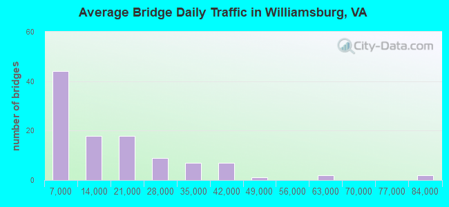
- 1,641,437Total average daily traffic
- 62,934Total average daily truck traffic
- National Bridge Inventory (NBI) Registered Bridges for Williamsburg
- No street view available for this location
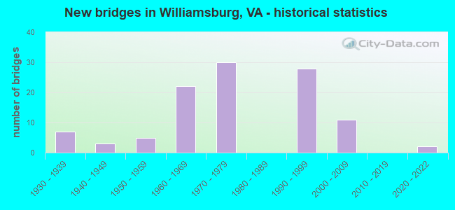
- New bridges - historical statistics
- 71930-1939
- 31940-1949
- 51950-1959
- 221960-1969
- 301970-1979
- 281990-1999
- 112000-2009
- 22020-2022
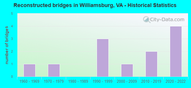
- Reconstructed bridges - Historical Statistics
- 11960-1969
- 11970-1979
- 01980-1989
- 31990-1999
- 12000-2009
- 22010-2019
- 42020-2022
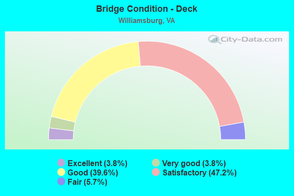
- Bridge Condition - Deck
- 3.8%Excellent
- 3.8%Very good
- 39.6%Good
- 47.2%Satisfactory
- 5.7%Fair
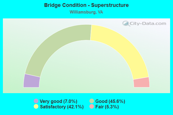
- Bridge Condition - Superstructure
- 7.0%Very good
- 45.6%Good
- 42.1%Satisfactory
- 5.3%Fair
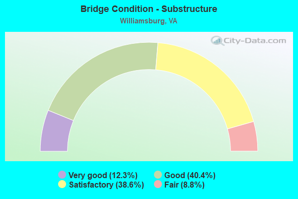
- Bridge Condition - Substructure
- 12.3%Very good
- 40.4%Good
- 38.6%Satisfactory
- 8.8%Fair
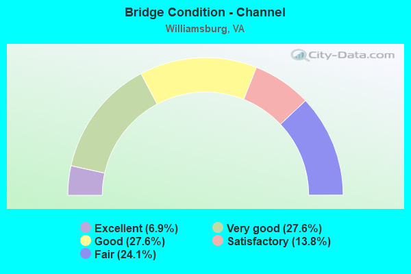
- Bridge Condition - Channel
- 6.9%Excellent
- 27.6%Very good
- 27.6%Good
- 13.8%Satisfactory
- 24.1%Fair
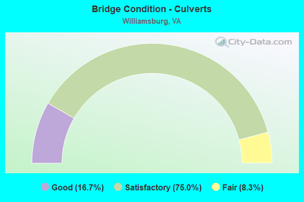
- Bridge Condition - Culverts
- 16.7%Good
- 75.0%Satisfactory
- 8.3%Fair
Find on map >> Show street view
Structure Number: 25207, Location: 0.60 Mi To Route 658 (Lat: 37.299206, Lng: -76.745864), Route carried "on" structure: County highway 612, Year Built: 1999, Status: Open, Structure Length: 7.22m (23.69ft), Average Daily Traffic: 12,902 (year 2020), Truck Traffic: 2%, Average Future Daily Traffic: 18,063 (year 2040), Design Load: HS 20+Mod, Features Intersected: Route 199, Facility Carried by Structure: Longhill Rd
Minimum Vertical Clearance: 30+ m (98+ ft), Kilometerpoint: 0.000, Lanes on structure: 4, Lanes under structure: 4, Owner: State Highway Agency, Approaching Roadway Width: 33.8m (110.9ft), Skew: 11 degrees, Material/Design: Steel continuous, Design/Construction: Stringer/Multi-beam, Number Of Spans In Main Unit: 2, Length of Maximum Span: 37.5m (123.0ft), Curb or Sidewalk Widths: Left: 1.2m (3.9ft), Right: 1.2m (3.9ft), Curb-To-Curb Width: 31.4m (103.0ft), Out-to-Out Width: 34.7m (113.8ft)
Condition: Deck: Satisfactory, Superstructure: Good, Substructure: Satisfactory, Operating Rating: 71.7 metric tons, Method Used To Determine Operating Rating: Load and Resistance Factor (LRFR), Inventory Rating: 55.3 metric tons, Method Used To Determine Inventory Rating: Load and Resistance Factor (LRFR), Structural Evaluation: Equal to present minimum criteria, Deck Geometry: Superior to present desirable criteria, Underclear: Superior to present desirable criteria, Approach Roadway Alignment: Equal to present desirable criteria, Designated Inspection Frequency: Every 24 months, Inspection Date: July 2021, Deck Structure Type: Concrete Cast-file-Place, Wearing Surface/Protective System: Wearing Surface: Monolithic Concrete, Deck Protection: Epoxy Coated Reinforcing
Find on map >> Show street view
Structure Number: 25208, Location: 2.60 Mi To Route 60 (Lat: 37.300803, Lng: -76.744314), Route carried "on" structure: State highway 199, Year Built: 1999, Status: Open, Structure Length: 0.98m (3.22ft), Average Daily Traffic: 26,608 (year 2020), Truck Traffic: 1%, Average Future Daily Traffic: 37,251 (year 2040), Design Load: HS 20+Mod, Features Intersected: Stream, Facility Carried by Structure: Hummelsine Parkway
Minimum Vertical Clearance: 30+ m (98+ ft), Kilometerpoint: 0.000, Lanes on structure: 5, Base Highway Network: Yes, Owner: State Highway Agency, Approaching Roadway Width: 38.7m (127.0ft), Skew: 1 degrees, Material/Design: Concrete, Design/Construction: Culvert, Number Of Spans In Main Unit: 3, Length of Maximum Span: 3.0m (9.8ft)
Condition: Channel: Fair, Culverts: Satisfactory, Operating Rating: 89.8 metric tons, Method Used To Determine Operating Rating: Load Factor (LF), Inventory Rating: 89.8 metric tons, Method Used To Determine Inventory Rating: Load Factor (LF), Structural Evaluation: Equal to present minimum criteria, Waterway Adequacy: Equal to present desirable criteria, Approach Roadway Alignment: Equal to present desirable criteria, Designated Inspection Frequency: Every 24 months, Inspection Date: March 2021
Find on map >> Show street view
Structure Number: 25209, Location: 0.23 Mi To Route 612 (Lat: 37.302108, Lng: -76.743969), Route carried "on" structure: State highway 199, Year Built: 1999, Status: Open, Structure Length: 1.28m (4.20ft), Average Daily Traffic: 23,063 (year 2020), Truck Traffic: 2%, Average Future Daily Traffic: 32,288 (year 2040), Design Load: HS 20+Mod, Features Intersected: Branch
Minimum Vertical Clearance: 30+ m (98+ ft), Kilometerpoint: 0.000, Lanes on structure: 5, Base Highway Network: Yes, Owner: State Highway Agency, Approaching Roadway Width: 13.4m (44.0ft), Skew: 30 degrees, Material/Design: Concrete, Design/Construction: Culvert, Number Of Spans In Main Unit: 4, Length of Maximum Span: 3.0m (9.8ft)
Condition: Channel: Fair, Culverts: Fair, Operating Rating: 89.8 metric tons, Method Used To Determine Operating Rating: Load Factor (LF), Inventory Rating: 89.8 metric tons, Method Used To Determine Inventory Rating: Load Factor (LF), Structural Evaluation: Somewhat better than minimum adequacy, Waterway Adequacy: Equal to present desirable criteria, Approach Roadway Alignment: Equal to present desirable criteria, Designated Inspection Frequency: Every 24 months, Inspection Date: July 2021
Find on map >> Show street view
Structure Number: 2521, Location: 0.80 Mi To Route 658 (Lat: 37.321358, Lng: -76.751867), Route carried "on" structure: State highway 199, Year Built: 1999, Status: Open, Structure Length: 1.31m (4.30ft), Average Daily Traffic: 23,063 (year 2020), Truck Traffic: 2%, Average Future Daily Traffic: 32,288 (year 2040), Design Load: HS 20+Mod, Features Intersected: Branch
Minimum Vertical Clearance: 30+ m (98+ ft), Kilometerpoint: 0.000, Lanes on structure: 4, Base Highway Network: Yes, Owner: State Highway Agency, Approaching Roadway Width: 34.4m (112.9ft), Skew: 1 degrees, Material/Design: Concrete, Design/Construction: Culvert, Number Of Spans In Main Unit: 4, Length of Maximum Span: 3.0m (9.8ft)
Condition: Channel: Fair, Culverts: Satisfactory, Operating Rating: 89.8 metric tons, Method Used To Determine Operating Rating: Load Factor (LF), Inventory Rating: 61.7 metric tons, Method Used To Determine Inventory Rating: Load Factor (LF), Structural Evaluation: Equal to present minimum criteria, Waterway Adequacy: Equal to present minimum criteria, Approach Roadway Alignment: Equal to present desirable criteria, Designated Inspection Frequency: Every 24 months, Inspection Date: July 2021
Find on map >> Show street view
Structure Number: 25212, Location: 0.94 Mi To I-64 (Lat: 37.344206, Lng: -76.742650), Route carried "on" structure: State highway 199, Year Built: 1999, Status: Open, Structure Length: 5.39m (17.68ft), Average Daily Traffic: 11,269 (year 2020), Truck Traffic: 2%, Average Future Daily Traffic: 15,777 (year 2040), Design Load: HS 20+Mod, Features Intersected: Mooretown Rd, Facility Carried by Structure: Humelsine Pky SBL
Minimum Vertical Clearance: 30.18m (99.02ft), Kilometerpoint: 0.000, Lanes on structure: 3, Lanes under structure: 6, Base Highway Network: Yes, Owner: State Highway Agency, Approaching Roadway Width: 15.8m (51.8ft), Material/Design: Prestressed concrete continuous, Design/Construction: Stringer/Multi-beam, Number Of Spans In Main Unit: 2, Length of Maximum Span: 27.1m (88.9ft), Curb-To-Curb Width: 15.8m (51.8ft), Out-to-Out Width: 16.8m (55.1ft)
Condition: Deck: Satisfactory, Superstructure: Good, Substructure: Satisfactory, Operating Rating: 67.9 metric tons, Method Used To Determine Operating Rating: Load and Resistance Factor (LRFR), Inventory Rating: 52.3 metric tons, Method Used To Determine Inventory Rating: Load and Resistance Factor (LRFR), Structural Evaluation: Equal to present minimum criteria, Deck Geometry: Somewhat better than minimum adequacy, Approach Roadway Alignment: Equal to present desirable criteria, Designated Inspection Frequency: Every 24 months, Inspection Date: September 2021, Deck Structure Type: Concrete Cast-file-Place, Wearing Surface/Protective System: Wearing Surface: Monolithic Concrete, Deck Protection: Epoxy Coated Reinforcing
Find on map >> Show street view
Structure Number: 25213, Location: 0.90 Mi Fr I-64 (Lat: 37.344342, Lng: -76.742867), Route carried "on" structure: State highway 199, Year Built: 1999, Status: Open, Structure Length: 5.39m (17.68ft), Average Daily Traffic: 11,269 (year 2020), Truck Traffic: 2%, Average Future Daily Traffic: 15,777 (year 2040), Design Load: HS 20+Mod, Features Intersected: Mooretown Rd, Facility Carried by Structure: Humelsine Pkwy Nbl
Minimum Vertical Clearance: 30+ m (98+ ft), Kilometerpoint: 0.000, Lanes on structure: 3, Lanes under structure: 6, Base Highway Network: Yes, Owner: State Highway Agency, Approaching Roadway Width: 16.5m (54.1ft), Material/Design: Prestressed concrete continuous, Design/Construction: Stringer/Multi-beam, Number Of Spans In Main Unit: 2, Length of Maximum Span: 26.8m (87.9ft), Curb-To-Curb Width: 15.8m (51.8ft), Out-to-Out Width: 16.9m (55.4ft)
Condition: Deck: Satisfactory, Superstructure: Good, Substructure: Good, Operating Rating: 49.0 metric tons, Method Used To Determine Operating Rating: Load and Resistance Factor (LRFR), Inventory Rating: 37.2 metric tons, Method Used To Determine Inventory Rating: Load and Resistance Factor (LRFR), Structural Evaluation: Better than present minimum criteria, Deck Geometry: Better than present minimum criteria, Approach Roadway Alignment: Equal to present desirable criteria, Designated Inspection Frequency: Every 24 months, Inspection Date: September 2021, Deck Structure Type: Concrete Cast-file-Place, Wearing Surface/Protective System: Wearing Surface: Monolithic Concrete, Deck Protection: Epoxy Coated Reinforcing
Find on map >> Show street view
Structure Number: 25281, Location: 0.00 Mi To 64 (Lat: 37.240589, Lng: -76.634275), Route carried "on" structure: Ramp Interstate 64, Year Built: 2002, Status: Open, Structure Length: 20.79m (68.21ft), Average Daily Traffic: 2,929 (year 2020), Average Future Daily Traffic: 4,101 (year 2040), Design Load: HS 20+Mod, Features Intersected: IS 64 EBL & WBL, Facility Carried by Structure: Ramps D & E
Minimum Vertical Clearance: 30.18m (99.02ft), Kilometerpoint: 0.000, Lanes on structure: 3, Lanes under structure: 6, Base Highway Network: Yes, Owner: State Highway Agency, Approaching Roadway Width: 20.7m (67.9ft), Skew: 35 degrees, Material/Design: Steel continuous, Design/Construction: Stringer/Multi-beam, Number Of Spans In Main Unit: 4, Length of Maximum Span: 69.2m (227.0ft), Curb-To-Curb Width: 20.7m (67.9ft), Out-to-Out Width: 22.3m (73.2ft)
Condition: Deck: Satisfactory, Superstructure: Satisfactory, Substructure: Satisfactory, Operating Rating: 66.7 metric tons, Method Used To Determine Operating Rating: Load and Resistance Factor (LRFR), Inventory Rating: 51.4 metric tons, Method Used To Determine Inventory Rating: Load and Resistance Factor (LRFR), Structural Evaluation: Equal to present minimum criteria, Deck Geometry: Superior to present desirable criteria, Underclear: High priority of corrective action, Approach Roadway Alignment: Equal to present desirable criteria, Designated Inspection Frequency: Every 24 months, Inspection Date: October 2021, Deck Structure Type: Concrete Cast-file-Place, Wearing Surface/Protective System: Wearing Surface: Monolithic Concrete, Deck Protection: Epoxy Coated Reinforcing
Find on map >> Show street view
Structure Number: 25282, Location: 0.00 Mi To Busch Gardens (Lat: 37.238253, Lng: -76.634489), Route carried "on" structure: Ramp Interstate 64, Year Built: 2002, Status: Open, Structure Length: 6.22m (20.41ft), Average Daily Traffic: 10,000 (year 2000), Truck Traffic: 10%, Average Future Daily Traffic: 18,868 (year 2040), Design Load: HS 20+Mod, Features Intersected: IS 64 Ramp, Facility Carried by Structure: Ramps D & E
Minimum Vertical Clearance: 30+ m (98+ ft), Kilometerpoint: 0.000, Lanes on structure: 5, Lanes under structure: 1, Base Highway Network: Yes, Owner: State Highway Agency, Approaching Roadway Width: 28.7m (94.2ft), Skew: 33 degrees, Material/Design: Steel continuous, Design/Construction: Stringer/Multi-beam, Number Of Spans In Main Unit: 2, Number Of Approach Spans: 1, Length of Maximum Span: 26.5m (86.9ft), Curb-To-Curb Width: 26.6m (87.3ft), Out-to-Out Width: 28.3m (92.8ft)
Condition: Deck: Satisfactory, Superstructure: Satisfactory, Substructure: Satisfactory, Operating Rating: 46.1 metric tons, Method Used To Determine Operating Rating: Load and Resistance Factor (LRFR), Inventory Rating: 35.3 metric tons, Method Used To Determine Inventory Rating: Load and Resistance Factor (LRFR), Structural Evaluation: Equal to present minimum criteria, Deck Geometry: Superior to present desirable criteria, Approach Roadway Alignment: Equal to present desirable criteria, Designated Inspection Frequency: Every 24 months, Inspection Date: August 2020, Deck Structure Type: Concrete Cast-file-Place, Wearing Surface/Protective System: Wearing Surface: Monolithic Concrete, Deck Protection: Epoxy Coated Reinforcing
Find on map >> Show street view
Structure Number: 25283, Location: 0.00 Mi To Busch Gardens (Lat: 37.237514, Lng: -76.634600), Route carried "on" structure: Ramp Interstate 64, Year Built: 2002, Status: Open, Structure Length: 12.83m (42.09ft), Average Daily Traffic: 511 (year 1999), Truck Traffic: 1%, Average Future Daily Traffic: 979 (year 2040), Design Load: HS 20+Mod, Features Intersected: Route 143; 60 & CSX RR, Facility Carried by Structure: Ramps D & E
Minimum Vertical Clearance: 30+ m (98+ ft), Kilometerpoint: 0.000, Lanes on structure: 6, Lanes under structure: 9, Base Highway Network: Yes, Owner: State Highway Agency, Approaching Roadway Width: 26.8m (87.9ft), Skew: 30 degrees, Material/Design: Steel continuous, Design/Construction: Stringer/Multi-beam, Number Of Spans In Main Unit: 3, Length of Maximum Span: 46.3m (151.9ft), Curb-To-Curb Width: 30.3m (99.4ft), Out-to-Out Width: 32.1m (105.3ft)
Condition: Deck: Satisfactory, Superstructure: Good, Substructure: Good, Operating Rating: 76.0 metric tons, Method Used To Determine Operating Rating: Load and Resistance Factor (LRFR), Inventory Rating: 58.6 metric tons, Method Used To Determine Inventory Rating: Load and Resistance Factor (LRFR), Structural Evaluation: Better than present minimum criteria, Deck Geometry: Superior to present desirable criteria, Underclear: Better than present minimum criteria, Approach Roadway Alignment: Equal to present desirable criteria, Designated Inspection Frequency: Every 24 months, Inspection Date: August 2020, Deck Structure Type: Concrete Cast-file-Place, Wearing Surface/Protective System: Wearing Surface: Monolithic Concrete, Deck Protection: Epoxy Coated Reinforcing
Find on map >> Show street view
Structure Number: 25512, Location: 1.20 Mi To Route 5 (Lat: 37.273492, Lng: -76.752144), Route carried "on" structure: State highway 199, Year Built: 1999, Status: Open, Structure Length: 5.61m (18.41ft), Average Daily Traffic: 13,108 (year 2020), Truck Traffic: 2%, Average Future Daily Traffic: 18,351 (year 2040), Design Load: HS 20+Mod, Features Intersected: Monticello Ave
Minimum Vertical Clearance: 30+ m (98+ ft), Kilometerpoint: 0.000, Lanes on structure: 2, Lanes under structure: 4, Base Highway Network: Yes, Owner: State Highway Agency, Approaching Roadway Width: 12.8m (42.0ft), Skew: 1 degrees, Material/Design: Steel, Design/Construction: Stringer/Multi-beam, Number Of Spans In Main Unit: 1, Length of Maximum Span: 56.1m (184.1ft), Curb-To-Curb Width: 12.2m (40.0ft), Out-to-Out Width: 13.7m (44.9ft)
Condition: Deck: Good, Superstructure: Good, Substructure: Good, Operating Rating: 89.8 metric tons, Method Used To Determine Operating Rating: Load and Resistance Factor (LRFR), Inventory Rating: 78.7 metric tons, Method Used To Determine Inventory Rating: Load and Resistance Factor (LRFR), Structural Evaluation: Better than present minimum criteria, Deck Geometry: Better than present minimum criteria, Underclear: Superior to present desirable criteria, Approach Roadway Alignment: Equal to present desirable criteria, Length Of Structure Improvement: 5.64m (18.50ft), Designated Inspection Frequency: Every 24 months, Inspection Date: September 2021, Bridge Improvement Cost: $462,000, Roadway Improvement Cost: $45,000, Total Project Cost: $508,000, Deck Structure Type: Concrete Cast-file-Place, Wearing Surface/Protective System: Wearing Surface: Monolithic Concrete, Deck Protection: Epoxy Coated Reinforcing
Find on map >> Show street view
Structure Number: 25513, Location: 1.50 Mi To Route 5 (Lat: 37.273344, Lng: -76.752336), Route carried "on" structure: State highway 199, Year Built: 1999, Status: Open, Structure Length: 5.58m (18.31ft), Average Daily Traffic: 13,108 (year 2020), Truck Traffic: 2%, Average Future Daily Traffic: 18,351 (year 2040), Design Load: HS 20+Mod, Features Intersected: Monticello Ave
Minimum Vertical Clearance: 30+ m (98+ ft), Kilometerpoint: 0.000, Lanes on structure: 3, Lanes under structure: 2, Base Highway Network: Yes, Owner: State Highway Agency, Approaching Roadway Width: 12.8m (42.0ft), Skew: 1 degrees, Material/Design: Steel, Design/Construction: Stringer/Multi-beam, Number Of Spans In Main Unit: 1, Length of Maximum Span: 55.8m (183.1ft), Curb-To-Curb Width: 12.5m (41.0ft), Out-to-Out Width: 13.7m (44.9ft)
Condition: Deck: Good, Superstructure: Good, Substructure: Good, Operating Rating: 89.8 metric tons, Method Used To Determine Operating Rating: Load and Resistance Factor (LRFR), Inventory Rating: 81.3 metric tons, Method Used To Determine Inventory Rating: Load and Resistance Factor (LRFR), Structural Evaluation: Better than present minimum criteria, Deck Geometry: High priority of replacement, Underclear: Superior to present desirable criteria, Approach Roadway Alignment: Equal to present desirable criteria, Length Of Structure Improvement: 5.64m (18.50ft), Designated Inspection Frequency: Every 24 months, Inspection Date: September 2021, Bridge Improvement Cost: $462,000, Roadway Improvement Cost: $30,000, Total Project Cost: $493,000, Deck Structure Type: Concrete Cast-file-Place, Wearing Surface/Protective System: Wearing Surface: Monolithic Concrete, Deck Protection: Epoxy Coated Reinforcing
Find on map >> Show street view
Structure Number: 25978, Location: 0.60 Mi To Rte 658 (Lat: 37.299794, Lng: -76.747128), Route carried "on" structure: County highway 612, Year Built: 1999, Status: Open, Structure Length: 1.46m (4.79ft), Average Daily Traffic: 12,902 (year 2020), Truck Traffic: 2%, Average Future Daily Traffic: 18,063 (year 2040), Design Load: HS 20+Mod, Features Intersected: Chisel Run, Facility Carried by Structure: Longhill Road
Minimum Vertical Clearance: 30+ m (98+ ft), Kilometerpoint: 4.875, Lanes on structure: 5, Owner: State Highway Agency, Approaching Roadway Width: 16.5m (54.1ft), Material/Design: Concrete, Design/Construction: Culvert, Number Of Spans In Main Unit: 4, Length of Maximum Span: 3.7m (12.1ft)
Condition: Channel: Fair, Culverts: Satisfactory, Operating Rating: 89.8 metric tons, Method Used To Determine Operating Rating: Load Factor (LF), Inventory Rating: 89.8 metric tons, Method Used To Determine Inventory Rating: Load Factor (LF), Structural Evaluation: Equal to present minimum criteria, Waterway Adequacy: Equal to present desirable criteria, Approach Roadway Alignment: Equal to present desirable criteria, Designated Inspection Frequency: Every 24 months, Inspection Date: November 2020
Find on map >> Show street view
Structure Number: 26142, Location: 0.23 Mi To Route 614 (Lat: 37.263153, Lng: -76.784606), Route carried "on" structure: State highway 5000, Year Built: 2001, Status: Open, Structure Length: 24.99m (81.99ft), Average Daily Traffic: 10,741 (year 2020), Truck Traffic: 5%, Average Future Daily Traffic: 15,037 (year 2040), Design Load: HS 20+Mod, Features Intersected: Powhatan Creek
Minimum Vertical Clearance: 30+ m (98+ ft), Kilometerpoint: 0.000, Lanes on structure: 2, Base Highway Network: Yes, Owner: State Highway Agency, Approaching Roadway Width: 13.7m (44.9ft), Material/Design: Prestressed concrete, Design/Construction: Stringer/Multi-beam, Number Of Spans In Main Unit: 10, Length of Maximum Span: 25.0m (82.0ft), Curb-To-Curb Width: 12.8m (42.0ft), Out-to-Out Width: 14.0m (45.9ft)
Condition: Deck: Satisfactory, Superstructure: Satisfactory, Substructure: Satisfactory, Channel: Very good, Operating Rating: 67.1 metric tons, Method Used To Determine Operating Rating: Load and Resistance Factor (LRFR), Inventory Rating: 51.7 metric tons, Method Used To Determine Inventory Rating: Load and Resistance Factor (LRFR), Structural Evaluation: Equal to present minimum criteria, Deck Geometry: Somewhat better than minimum adequacy, Waterway Adequacy: Equal to present desirable criteria, Approach Roadway Alignment: Better than present minimum criteria, Designated Inspection Frequency: Every 24 months, Inspection Date: December 2021, Deck Structure Type: Concrete Cast-file-Place, Wearing Surface/Protective System: Wearing Surface: Epoxy Overlay, Deck Protection: Epoxy Coated Reinforcing
Find on map >> Show street view
Structure Number: 26215, Location: 1.40 Mi To Route 199 (Lat: 37.238206, Lng: -76.747003), Route carried "on" structure: State highway 31, Year Built: 1999, Status: Open, Structure Length: 1.86m (6.10ft), Average Daily Traffic: 7,833 (year 2020), Truck Traffic: 2%, Average Future Daily Traffic: 9,775 (year 2040), Design Load: HS 20+Mod, Features Intersected: Lake Powell, Facility Carried by Structure: Jamestown Road
Minimum Vertical Clearance: 30+ m (98+ ft), Kilometerpoint: 37.261, Lanes on structure: 2, Owner: State Highway Agency, Approaching Roadway Width: 12.8m (42.0ft), Material/Design: Concrete, Design/Construction: Box Beam or Girders - Multiple, Number Of Spans In Main Unit: 1, Length of Maximum Span: 18.6m (61.0ft), Curb-To-Curb Width: 12.8m (42.0ft), Out-to-Out Width: 13.4m (44.0ft)
Condition: Deck: Good, Superstructure: Satisfactory, Substructure: Very good, Channel: Very good, Operating Rating: 71.7 metric tons, Method Used To Determine Operating Rating: Load and Resistance Factor (LRFR), Inventory Rating: 55.3 metric tons, Method Used To Determine Inventory Rating: Load and Resistance Factor (LRFR), Structural Evaluation: Equal to present minimum criteria, Deck Geometry: Somewhat better than minimum adequacy, Waterway Adequacy: Superior to present desirable criteria, Approach Roadway Alignment: Equal to present desirable criteria, Designated Inspection Frequency: Every 24 months, Inspection Date: January 2022, Deck Structure Type: Other, Wearing Surface/Protective System: Wearing Surface: Bituminous, Membrane: Epoxy
Find on map >> Show street view
Structure Number: 27254, Location: 1.69 Mi To Begin Rte 199 (Lat: 37.248169, Lng: -76.712342), Route carried "on" structure: State highway 199, Year Built: 2004, Status: Open, Structure Length: 25.54m (83.79ft), Average Daily Traffic: 15,348 (year 2020), Truck Traffic: 3%, Average Future Daily Traffic: 21,487 (year 2040), Design Load: HS 20+Mod, Features Intersected: College Creek
Minimum Vertical Clearance: 30+ m (98+ ft), Kilometerpoint: 0.000, Lanes on structure: 2, Base Highway Network: Yes, Owner: State Highway Agency, Approaching Roadway Width: 12.2m (40.0ft), Material/Design: Prestressed concrete continuous, Design/Construction: Stringer/Multi-beam, Number Of Spans In Main Unit: 12, Length of Maximum Span: 21.3m (69.9ft), Curb-To-Curb Width: 12.2m (40.0ft), Out-to-Out Width: 12.8m (42.0ft)
Condition: Deck: Good, Superstructure: Good, Substructure: Good, Channel: Very good, Operating Rating: 67.5 metric tons, Method Used To Determine Operating Rating: Load Factor (LF), Inventory Rating: 43.2 metric tons, Method Used To Determine Inventory Rating: Load Factor (LF), Structural Evaluation: Better than present minimum criteria, Deck Geometry: Better than present minimum criteria, Waterway Adequacy: Equal to present desirable criteria, Approach Roadway Alignment: Equal to present desirable criteria, Designated Inspection Frequency: Every 24 months, Underwater Inspection Frequency: Every 60 months, Inspection Date: June 2021, Underwater Inspection Date: November 2020, Deck Structure Type: Concrete Cast-file-Place, Wearing Surface/Protective System: Wearing Surface: Monolithic Concrete, Deck Protection: Epoxy Coated Reinforcing
Find on map >> Show street view
Structure Number: 31199, Location: 0.79 Mi To Int Rte 143 (Lat: 37.293911, Lng: -76.676475), Route carried "on" structure: Interstate 64, Year Built: 2021, Status: Open, Structure Length: 25.27m (82.91ft), Average Daily Traffic: 35,615 (year 2018), Truck Traffic: 9%, Average Future Daily Traffic: 98,708 (year 2035), Design Load: HL 93, Features Intersected: QUEEN CREEK
Minimum Vertical Clearance: 30+ m (98+ ft), Kilometerpoint: 385.436, Lanes on structure: 2, Base Highway Network: Yes, Owner: State Highway Agency, Approaching Roadway Width: 6.7m (22.0ft), Skew: 9 degrees, Material/Design: Prestressed concrete continuous, Design/Construction: Stringer/Multi-beam, Number Of Spans In Main Unit: 11, Length of Maximum Span: 25.7m (84.3ft), Curb-To-Curb Width: 18.3m (60.0ft), Out-to-Out Width: 19.9m (65.3ft)
Condition: Deck: Excellent, Superstructure: Very good, Substructure: Very good, Channel: Excellent, Operating Rating: 80.1 metric tons, Method Used To Determine Operating Rating: Load and Resistance Factor (LRFR), Inventory Rating: 47.6 metric tons, Method Used To Determine Inventory Rating: Load and Resistance Factor (LRFR), Structural Evaluation: Equal to present desirable criteria, Deck Geometry: Superior to present desirable criteria, Waterway Adequacy: Equal to present desirable criteria, Approach Roadway Alignment: Equal to present desirable criteria, Length Of Structure Improvement: 27.49m (90.19ft), Designated Inspection Frequency: Every 24 months, Inspection Date: May 2021, Bridge Improvement Cost: $1,753,000, Roadway Improvement Cost: $50,000, Total Project Cost: $2,279,000, Deck Structure Type: Concrete Cast-file-Place, Wearing Surface/Protective System: Deck Protection: Other Coated Reinforcing
Find on map >> Show street view
Structure Number: 312, Location: 0.80 Mi To Int Rte 143 (Lat: 37.292300, Lng: -76.674933), Route carried "on" structure: Interstate 64, Year Built: 2021, Status: Open, Structure Length: 27.08m (88.85ft), Average Daily Traffic: 28,541 (year 2020), Truck Traffic: 9%, Average Future Daily Traffic: 39,957 (year 2040), Design Load: HL 93, Features Intersected: QUEENS CREEK
Minimum Vertical Clearance: 30+ m (98+ ft), Kilometerpoint: 385.516, Lanes on structure: 3, Base Highway Network: Yes, Owner: State Highway Agency, Approaching Roadway Width: 18.9m (62.0ft), Skew: 9 degrees, Material/Design: Prestressed concrete continuous, Design/Construction: Stringer/Multi-beam, Number Of Spans In Main Unit: 12, Length of Maximum Span: 25.7m (84.3ft), Curb-To-Curb Width: 18.3m (60.0ft), Out-to-Out Width: 19.3m (63.3ft)
Condition: Deck: Excellent, Superstructure: Very good, Substructure: Very good, Channel: Excellent, Operating Rating: 69.6 metric tons, Method Used To Determine Operating Rating: Load and Resistance Factor (LRFR), Inventory Rating: 53.6 metric tons, Method Used To Determine Inventory Rating: Load and Resistance Factor (LRFR), Structural Evaluation: Equal to present desirable criteria, Deck Geometry: Better than present minimum criteria, Waterway Adequacy: Equal to present desirable criteria, Approach Roadway Alignment: Equal to present desirable criteria, Designated Inspection Frequency: Every 24 months, Underwater Inspection Frequency: Every 60 months, Inspection Date: November 2021, Underwater Inspection Date: November 2020, Deck Structure Type: Concrete Cast-file-Place, Wearing Surface/Protective System: Wearing Surface: Monolithic Concrete, Deck Protection: Other
Find on map >> Show street view
Structure Number: 4290013P, Location: 2.6 MILES EAST OF HUBBARD (Lat: 37.281444, Lng: -76.628056), Route carried "on" structure: Federal lands road 1, Year Built: 1964, Status: Open, Structure Length: 4.98m (16.34ft), Average Daily Traffic: 3,591 (year 2007), Truck Traffic: 1%, Average Future Daily Traffic: 3,950 (year 2027), Design Load: H 15, Features Intersected: PENNIMAN ROAD (VA ROUTE, Facility Carried by Structure: COLONIAL PARKWAY
Minimum Vertical Clearance: 30+ m (98+ ft), Kilometerpoint: 13.341, Lanes on structure: 2, Lanes under structure: 2, Owner: National Park Service, Approaching Roadway Width: 13.4m (44.0ft), Skew: 3 degrees, Material/Design: Concrete continuous, Design/Construction: Slab, Number Of Spans In Main Unit: 4, Length of Maximum Span: 14.3m (46.9ft), Curb or Sidewalk Widths: Left: 0.6m (2.0ft), Right: 0.6m (2.0ft), Curb-To-Curb Width: 10.4m (34.1ft), Out-to-Out Width: 12.7m (41.7ft)
Condition: Deck: Fair, Superstructure: Satisfactory, Substructure: Satisfactory, Operating Rating: 34.5 metric tons, Method Used To Determine Operating Rating: Field evaluation and documented engineering judgment, Inventory Rating: 20.9 metric tons, Method Used To Determine Inventory Rating: Field evaluation and documented engineering judgment, Structural Evaluation: Somewhat better than minimum adequacy, Deck Geometry: Somewhat better than minimum adequacy, Underclear: Meets minimum limits, Approach Roadway Alignment: Equal to present minimum criteria, Designated Inspection Frequency: Every 24 months, Inspection Date: June 2021, Bridge Improvement Cost: $260,000, Roadway Improvement Cost: $26,000, Total Project Cost: $390,000 ( Estimate for 2021), Deck Structure Type: Concrete Cast-file-Place, Wearing Surface/Protective System: Wearing Surface: Monolithic Concrete
Find on map >> Show street view
Structure Number: 4290014P, Location: 0.7 MILES EAST OF PARKWAY (Lat: 37.278694, Lng: -76.672111), Route carried "on" structure: Federal lands road 1, Year Built: 1964, Status: Open, Structure Length: 2.71m (8.89ft), Average Daily Traffic: 5,670 (year 2007), Truck Traffic: 1%, Average Future Daily Traffic: 6,237 (year 2027), Design Load: H 15, Features Intersected: HUBBARD'S LANE, Facility Carried by Structure: COLONIAL PARKWAY
Minimum Vertical Clearance: 30+ m (98+ ft), Kilometerpoint: 17.590, Lanes on structure: 2, Lanes under structure: 2, Owner: National Park Service, Approaching Roadway Width: 13.4m (44.0ft), Material/Design: Concrete continuous, Design/Construction: Slab, Number Of Spans In Main Unit: 3, Length of Maximum Span: 11.6m (38.1ft), Curb or Sidewalk Widths: Left: 0.6m (2.0ft), Right: 0.6m (2.0ft), Curb-To-Curb Width: 10.4m (34.1ft), Out-to-Out Width: 12.7m (41.7ft)
Condition: Deck: Satisfactory, Superstructure: Good, Substructure: Good, Operating Rating: 43.5 metric tons, Method Used To Determine Operating Rating: Field evaluation and documented engineering judgment, Inventory Rating: 25.4 metric tons, Method Used To Determine Inventory Rating: Field evaluation and documented engineering judgment, Structural Evaluation: Equal to present minimum criteria, Deck Geometry: Meets minimum limits, Underclear: Meets minimum limits, Approach Roadway Alignment: Equal to present minimum criteria, Designated Inspection Frequency: Every 24 months, Inspection Date: June 2021, Bridge Improvement Cost: $200,000, Roadway Improvement Cost: $20,000, Total Project Cost: $300,000 ( Estimate for 2021), Deck Structure Type: Concrete Cast-file-Place, Wearing Surface/Protective System: Wearing Surface: Monolithic Concrete
Find on map >> Show street view
Structure Number: 4290016P, Location: 0.9 MILES EAST OF LAFAYET (Lat: 37.276889, Lng: -76.685333), Route carried "on" structure: Federal lands road 1, Year Built: 1972, Status: Open, Structure Length: 1.55m (5.09ft), Average Daily Traffic: 5,670 (year 2007), Truck Traffic: 1%, Average Future Daily Traffic: 6,237 (year 2027), Design Load: HS 20, Features Intersected: COLONIAL PARKWAY, Facility Carried by Structure: PARKWAY DRIVE (VA
Minimum Vertical Clearance: 4.57m (14.99ft), Kilometerpoint: 18.781, Lanes on structure: 4, Lanes under structure: 2, Owner: National Park Service, Approaching Roadway Width: 15.9m (52.2ft), Material/Design: Concrete, Design/Construction: Arch - Deck, Number Of Spans In Main Unit: 1, Length of Maximum Span: 15.5m (50.9ft), Curb or Sidewalk Widths: Left: 1.6m (5.2ft), Right: 1.6m (5.2ft), Curb-To-Curb Width: 15.9m (52.2ft), Out-to-Out Width: 20.0m (65.6ft)
Condition: Superstructure: Good, Substructure: Good, Inventory Rating: 56.2 metric tons, Method Used To Determine Inventory Rating: Field evaluation and documented engineering judgment, Structural Evaluation: Better than present minimum criteria, Deck Geometry: Meets minimum limits, Underclear: Meets minimum limits, Approach Roadway Alignment: Equal to present minimum criteria, Designated Inspection Frequency: Every 24 months, Inspection Date: June 2021, Bridge Improvement Cost: $360,000, Roadway Improvement Cost: $36,000, Total Project Cost: $540,000 ( Estimate for 2021)
Find on map >> Show street view
Structure Number: 4290018P, Location: 0.5 MILES EAST OF LAFAYET (Lat: 37.278472, Lng: -76.690250), Route carried "on" structure: Federal lands road 1, Year Built: 1936, Status: Open, Structure Length: 1.55m (5.09ft), Average Daily Traffic: 5,670 (year 2007), Truck Traffic: 1%, Average Future Daily Traffic: 6,237 (year 2027), Design Load: H 20, Features Intersected: COLONIAL PARKWAY, Facility Carried by Structure: PAGE STREET (VA RO
Minimum Vertical Clearance: 4.57m (14.99ft), Kilometerpoint: 19.248, Lanes on structure: 4, Lanes under structure: 2, Owner: National Park Service, Approaching Roadway Width: 18.3m (60.0ft), Skew: 1 degrees, Material/Design: Concrete, Design/Construction: Arch - Deck, Number Of Spans In Main Unit: 1, Length of Maximum Span: 15.5m (50.9ft), Curb or Sidewalk Widths: Left: 1.4m (4.6ft), Right: 1.8m (5.9ft), Curb-To-Curb Width: 14.9m (48.9ft), Out-to-Out Width: 19.1m (62.7ft)
Condition: Superstructure: Satisfactory, Substructure: Good, Operating Rating: 31.7 metric tons, Method Used To Determine Operating Rating: Field evaluation and documented engineering judgment, Inventory Rating: 19.0 metric tons, Method Used To Determine Inventory Rating: Field evaluation and documented engineering judgment, Structural Evaluation: Meets minimum limits, Deck Geometry: High priority of replacement, Underclear: High priority of corrective action, Approach Roadway Alignment: Equal to present minimum criteria, Designated Inspection Frequency: Every 24 months, Inspection Date: June 2021, Bridge Improvement Cost: $50,000, Roadway Improvement Cost: $5,000, Total Project Cost: $75,000 ( Estimate for 2021)
Find on map >> Show street view
Structure Number: 4290019P, Location: 0.8 MILES NORTH OF NEWPOR (Lat: 37.275139, Lng: -76.699000), Route carried "on" structure: Federal lands road 1, Year Built: 1936, Status: Open, Structure Length: 4.33m (14.21ft), Average Daily Traffic: 5,670 (year 2007), Truck Traffic: 1%, Average Future Daily Traffic: 6,237 (year 2027), Design Load: H 15, Features Intersected: COLONIAL PARKWAY, Facility Carried by Structure: LAFAYETTE STREET
Minimum Vertical Clearance: 4.57m (14.99ft), Kilometerpoint: 20.213, Lanes on structure: 2, Lanes under structure: 2, Owner: National Park Service, Approaching Roadway Width: 9.8m (32.2ft), Material/Design: Concrete continuous, Design/Construction: Arch - Deck, Number Of Spans In Main Unit: 3, Length of Maximum Span: 15.2m (49.9ft), Curb or Sidewalk Widths: Left: 0.4m (1.3ft), Right: 1.2m (3.9ft), Curb-To-Curb Width: 7.3m (24.0ft), Out-to-Out Width: 10.2m (33.5ft)
Condition: Superstructure: Satisfactory, Substructure: Good, Channel: Good, Operating Rating: 46.3 metric tons, Method Used To Determine Operating Rating: Field evaluation and documented engineering judgment, Inventory Rating: 27.2 metric tons, Method Used To Determine Inventory Rating: Field evaluation and documented engineering judgment, Structural Evaluation: Equal to present minimum criteria, Deck Geometry: High priority of replacement, Underclear: High priority of corrective action, Waterway Adequacy: Equal to present desirable criteria, Approach Roadway Alignment: Equal to present minimum criteria, Designated Inspection Frequency: Every 24 months, Inspection Date: June 2021, Bridge Improvement Cost: $100,000, Roadway Improvement Cost: $10,000, Total Project Cost: $150,000 ( Estimate for 2021)
Find on map >> Show street view
Structure Number: 4290020P, Location: 0.9 MILES EAST OF VA ROUT (Lat: 37.266750, Lng: -76.702194), Route carried "on" structure: Federal lands road 1, Year Built: 1957, Status: Open, Structure Length: 1.55m (5.09ft), Average Daily Traffic: 3,274 (year 2007), Truck Traffic: 1%, Average Future Daily Traffic: 3,601 (year 2027), Design Load: H 15, Features Intersected: COLONIAL PARKWAY, Facility Carried by Structure: NEWPORT AVENUE
Minimum Vertical Clearance: 4.12m (13.52ft), Kilometerpoint: 21.195, Lanes on structure: 2, Lanes under structure: 2, Owner: National Park Service, Approaching Roadway Width: 11.0m (36.1ft), Skew: 1 degrees, Material/Design: Concrete, Design/Construction: Arch - Deck, Number Of Spans In Main Unit: 1, Length of Maximum Span: 15.5m (50.9ft), Curb or Sidewalk Widths: Left: 0.5m (1.6ft), Right: 1.5m (4.9ft), Curb-To-Curb Width: 9.1m (29.9ft), Out-to-Out Width: 12.1m (39.7ft)
Condition: Superstructure: Satisfactory, Substructure: Satisfactory, Inventory Rating: 58.0 metric tons, Method Used To Determine Inventory Rating: Field evaluation and documented engineering judgment, Structural Evaluation: Equal to present minimum criteria, Deck Geometry: Meets minimum limits, Underclear: High priority of corrective action, Approach Roadway Alignment: Equal to present minimum criteria, Designated Inspection Frequency: Every 24 months, Inspection Date: June 2021, Bridge Improvement Cost: $250,000, Roadway Improvement Cost: $25,000, Total Project Cost: $375,000 ( Estimate for 2021)
Find on map >> Show street view
Structure Number: 4290022P, Location: 0.9 MILES SOUTH OF ROUTE (Lat: 37.233861, Lng: -76.697028), Route carried "on" structure: Federal lands road 1, Year Built: 1942, Status: Open, Structure Length: 25.96m (85.17ft), Average Daily Traffic: 3,274 (year 2007), Truck Traffic: 1%, Average Future Daily Traffic: 3,601 (year 2027), Design Load: H 15, Features Intersected: HALFWAY CREEK, Facility Carried by Structure: COLONIAL PARKWAY
Minimum Vertical Clearance: 30+ m (98+ ft), Kilometerpoint: 24.720, Lanes on structure: 2, Owner: National Park Service, Approaching Roadway Width: 12.2m (40.0ft), Material/Design: Concrete, Design/Construction: Tee Beam, Number Of Spans In Main Unit: 15, Length of Maximum Span: 17.3m (56.8ft), Curb or Sidewalk Widths: Left: 0.9m (3.0ft), Right: 0.0m, Curb-To-Curb Width: 9.1m (29.9ft), Out-to-Out Width: 11.2m (36.7ft)
Condition: Deck: Satisfactory, Superstructure: Satisfactory, Substructure: Satisfactory, Channel: Very good, Operating Rating: 38.1 metric tons, Method Used To Determine Operating Rating: Field evaluation and documented engineering judgment, Inventory Rating: 22.7 metric tons, Method Used To Determine Inventory Rating: Field evaluation and documented engineering judgment, Structural Evaluation: Equal to present minimum criteria, Deck Geometry: Meets minimum limits, Waterway Adequacy: Equal to present desirable criteria, Approach Roadway Alignment: Equal to present desirable criteria, Designated Inspection Frequency: Every 24 months, Underwater Inspection Frequency: Every 60 months, Inspection Date: June 2021, Underwater Inspection Date: June 2018, Bridge Improvement Cost: $400,000, Roadway Improvement Cost: $40,000, Total Project Cost: $600,000 ( Estimate for 2021), Deck Structure Type: Concrete Cast-file-Place, Wearing Surface/Protective System: Wearing Surface: Monolithic Concrete
Find on map >> Show street view
Structure Number: 4290023P, Location: 1.6 MILES SOUTH OF VA ROU (Lat: 37.226083, Lng: -76.694722), Route carried "on" structure: Federal lands road 1, Year Built: 1956, Status: Open, Structure Length: 2.65m (8.69ft), Average Daily Traffic: 3,274 (year 2007), Truck Traffic: 1%, Average Future Daily Traffic: 3,601 (year 2027), Design Load: H 15, Features Intersected: COLLEGE CREEK, Facility Carried by Structure: COLONIAL PARKWAY
Minimum Vertical Clearance: 30+ m (98+ ft), Kilometerpoint: 25.814, Lanes on structure: 2, Owner: National Park Service, Approaching Roadway Width: 15.2m (49.9ft), Skew: 3 degrees, Material/Design: Steel, Design/Construction: Stringer/Multi-beam, Number Of Spans In Main Unit: 1, Length of Maximum Span: 26.5m (86.9ft), Curb-To-Curb Width: 9.8m (32.2ft), Out-to-Out Width: 11.1m (36.4ft)
Condition: Deck: Good, Superstructure: Good, Substructure: Satisfactory, Channel: Satisfactory, Operating Rating: 49.0 metric tons, Method Used To Determine Operating Rating: Field evaluation and documented engineering judgment, Inventory Rating: 29.0 metric tons, Method Used To Determine Inventory Rating: Field evaluation and documented engineering judgment, Structural Evaluation: Equal to present minimum criteria, Deck Geometry: Meets minimum limits, Waterway Adequacy: Equal to present desirable criteria, Approach Roadway Alignment: Equal to present minimum criteria, Designated Inspection Frequency: Every 24 months, Underwater Inspection Frequency: Every 60 months, Inspection Date: June 2021, Underwater Inspection Date: June 2018, Bridge Improvement Cost: $120,000, Roadway Improvement Cost: $12,000, Total Project Cost: $180,000 ( Estimate for 2021), Deck Structure Type: Concrete Cast-file-Place, Wearing Surface/Protective System: Wearing Surface: Monolithic Concrete
Find on map >> Show street view
Structure Number: 4290024P, Location: 4.6 MILES SOUTH OF VA ROU (Lat: 37.214833, Lng: -76.743833), Route carried "on" structure: Federal lands road 1, Year Built: 1956, Status: Open, Structure Length: 1.68m (5.51ft), Average Daily Traffic: 2,118 (year 2007), Truck Traffic: 10%, Average Future Daily Traffic: 2,330 (year 2027), Design Load: H 15, Features Intersected: MILL CREEK, Facility Carried by Structure: COLONIAL PARKWAY
Minimum Vertical Clearance: 30+ m (98+ ft), Kilometerpoint: 30.722, Lanes on structure: 2, Owner: National Park Service, Approaching Roadway Width: 15.2m (49.9ft), Material/Design: Steel, Design/Construction: Stringer/Multi-beam, Number Of Spans In Main Unit: 1, Length of Maximum Span: 16.5m (54.1ft), Curb-To-Curb Width: 9.8m (32.2ft), Out-to-Out Width: 11.1m (36.4ft)
Condition: Deck: Satisfactory, Superstructure: Good, Substructure: Good, Channel: Good, Operating Rating: 38.1 metric tons, Method Used To Determine Operating Rating: Field evaluation and documented engineering judgment, Inventory Rating: 22.7 metric tons, Method Used To Determine Inventory Rating: Field evaluation and documented engineering judgment, Structural Evaluation: Equal to present minimum criteria, Deck Geometry: Meets minimum limits, Waterway Adequacy: Equal to present desirable criteria, Approach Roadway Alignment: Equal to present desirable criteria, Designated Inspection Frequency: Every 24 months, Underwater Inspection Frequency: Every 60 months, Inspection Date: June 2021, Underwater Inspection Date: June 2018, Bridge Improvement Cost: $60,000, Roadway Improvement Cost: $6,000, Total Project Cost: $90,000 ( Estimate for 2021), Deck Structure Type: Concrete Cast-file-Place, Wearing Surface/Protective System: Wearing Surface: Monolithic Concrete
Find on map >> Show street view
Structure Number: 4290029P, Location: 2.3 MILES FROM TOUR ROAD (Lat: 37.203528, Lng: -76.739333), Route carried "on" structure: Spur Federal lands road 501, Year Built: 1957, Year Reconstructed: 2001, Status: Posted for load, Structure Length: 12.35m (40.52ft), Average Daily Traffic: 165 (year 2007), Truck Traffic: 1%, Average Future Daily Traffic: 182 (year 2027), Design Load: H 10, Features Intersected: CREEK, Facility Carried by Structure: LOOP DRIVE
Minimum Vertical Clearance: 30+ m (98+ ft), Kilometerpoint: 3.830, Lanes on structure: 1, Owner: National Park Service, Approaching Roadway Width: 4.3m (14.1ft), Material/Design: Wood or Timber, Design/Construction: Stringer/Multi-beam, Number Of Spans In Main Unit: 24, Length of Maximum Span: 5.2m (17.1ft), Curb-To-Curb Width: 4.0m (13.1ft), Out-to-Out Width: 4.3m (14.1ft)
Condition: Deck: Satisfactory, Superstructure: Satisfactory, Substructure: Satisfactory, Channel: Very good, Operating Rating: 33.6 metric tons, Method Used To Determine Operating Rating: Field evaluation and documented engineering judgment, Inventory Rating: 23.6 metric tons, Method Used To Determine Inventory Rating: Field evaluation and documented engineering judgment, Structural Evaluation: Equal to present minimum criteria, Deck Geometry: High priority of replacement, Waterway Adequacy: Equal to present desirable criteria, Approach Roadway Alignment: Equal to present desirable criteria, Bridge Posting: Required (Relationship of Operating Rating to Maximum Legal Load: 20.0 - 29.9% below), Designated Inspection Frequency: Every 24 months, Inspection Date: June 2021, Bridge Improvement Cost: $1,200,000, Roadway Improvement Cost: $120,000, Total Project Cost: $1,530,000 ( Estimate for 2021), Deck Structure Type: Wood or Timber
Find on map >> Show street view
Structure Number: 4290040P, Location: 0.7 miles north of Route (Lat: 37.254217, Lng: -76.703572), Route carried "on" structure: Federal lands road 1, Year Built: 2007, Status: Open, Structure Length: 0.99m (3.25ft), Average Daily Traffic: 3,274 (year 2007), Average Future Daily Traffic: 3,929 (year 2027), Design Load: HS 20, Features Intersected: PAPER MILL CREEK, Facility Carried by Structure: COLONIAL PARKWAY
Minimum Vertical Clearance: 30+ m (98+ ft), Kilometerpoint: 22.209, Lanes on structure: 2, Owner: National Park Service, Approaching Roadway Width: 12.2m (40.0ft), Skew: 1 degrees, Material/Design: Concrete, Design/Construction: Culvert, Number Of Spans In Main Unit: 3, Length of Maximum Span: 4.1m (13.5ft)
Condition: Channel: Satisfactory, Culverts: Satisfactory, Operating Rating: 86.2 metric tons, Method Used To Determine Operating Rating: Field evaluation and documented engineering judgment, Inventory Rating: 51.7 metric tons, Method Used To Determine Inventory Rating: Field evaluation and documented engineering judgment, Structural Evaluation: Equal to present minimum criteria, Waterway Adequacy: Equal to present minimum criteria, Approach Roadway Alignment: Equal to present desirable criteria, Designated Inspection Frequency: Every 24 months, Inspection Date: June 2021, Bridge Improvement Cost: $40,000, Roadway Improvement Cost: $4,000, Total Project Cost: $60,000 ( Estimate for 2021)
Find on map >> Show street view
Structure Number: 10508, Location: 2.18 Mi To Route 60 (Lat: 37.248697, Lng: -76.700522), Route carried "under" structure: Federal lands road , Year Built: 1976, Structure Length: 0. m, Average Daily Traffic: 1,000 (year 1994), Features Intersected: Colonial Pkwy, Facility Carried by Structure: Route 199 WBL
Minimum Vertical Clearance: 4.44m (14.57ft), Kilometerpoint: 0.000, Lanes on structure: 2, Lanes under structure: 2, Material/Design: Concrete, Design/Construction: Arch - Deck, Length of Maximum Span: 17.1m (56.1ft)
Find on map >> Show street view
Structure Number: 10511, Location: 2.08 Mi To Route 60 (Lat: 37.248831, Lng: -76.698519), Route carried "under" structure: Other road 619, Year Built: 1976, Structure Length: 0. m, Average Daily Traffic: 10 (year 1994), Features Intersected: S. England Street, Facility Carried by Structure: Route 199 EBL
Minimum Vertical Clearance: 3.81m (12.50ft), Kilometerpoint: 0.000, Lanes on structure: 2, Lanes under structure: 2, Material/Design: Concrete continuous, Design/Construction: Slab, Length of Maximum Span: 10.7m (35.1ft)
Find on map >> Show street view
Structure Number: 10513, Location: 2.08 Mi To Route 60 (Lat: 37.249011, Lng: -76.698525), Route carried "under" structure: Other road 619, Year Built: 1976, Structure Length: 0. m, Average Daily Traffic: 10 (year 1994), Features Intersected: S. England Street, Facility Carried by Structure: Route 199 WBL
Minimum Vertical Clearance: 4.09m (13.42ft), Kilometerpoint: 0.000, Lanes on structure: 2, Lanes under structure: 2, Material/Design: Concrete continuous, Design/Construction: Slab, Length of Maximum Span: 10.7m (35.1ft)
Find on map >> Show street view
Structure Number: 19828, Location: 3.56 Mi To Route 143 (Lat: 37.261092, Lng: -76.648817), Route carried "under" structure: County highway 641, Year Built: 1965, Structure Length: 0. m, Average Daily Traffic: 546 (year 1994), Features Intersected: Route 641 & Abandoned RR, Facility Carried by Structure: IS 64 EBL
Minimum Vertical Clearance: 7.32m (24.02ft), Kilometerpoint: 0.000, Lanes on structure: 4, Lanes under structure: 2, Material/Design: Prestressed concrete, Design/Construction: Stringer/Multi-beam, Length of Maximum Span: 23.2m (76.1ft)
Find on map >> Show street view
Structure Number: 1983, Location: 0.30 Mi To Route 199 (Lat: 37.261208, Lng: -76.648436), Route carried "under" structure: County highway 641, Year Built: 1965, Structure Length: 0. m, Average Daily Traffic: 2,000 (year 2008), Truck Traffic: 2%, Features Intersected: Penniman Rd & R.R., Facility Carried by Structure: I-64 WBL
Minimum Vertical Clearance: 6.91m (22.67ft), Kilometerpoint: 3.926, Lanes on structure: 4, Lanes under structure: 2, Material/Design: Prestressed concrete, Design/Construction: Stringer/Multi-beam, Length of Maximum Span: 23.2m (76.1ft)
Find on map >> Show street view
Structure Number: 19832, Location: 3.10 Mi Fr Rte 143 (Lat: 37.238286, Lng: -76.631936), Route carried "under" structure: Ramp Interstate 64, Year Built: 1965, Structure Length: 0. m, Average Daily Traffic: 18,000 (year 1994), Truck Traffic: 2%, Features Intersected: IS 64 WBL Ramp to 143
Minimum Vertical Clearance: 5.59m (18.34ft), Kilometerpoint: 0.000, Lanes on structure: 3, Lanes under structure: 1, Material/Design: Steel, Design/Construction: Stringer/Multi-beam, Length of Maximum Span: 23.9m (78.4ft)
Find on map >> Show street view
Structure Number: 19834, Location: 2.11 Mi To Route 143 (Lat: 37.278428, Lng: -76.663708), Route carried "under" structure: County highway 1314, Year Built: 1965, Structure Length: 0. m, Average Daily Traffic: 1,251 (year 2004), Features Intersected: Lakeshead Drive, Facility Carried by Structure: I-64 EBL
Minimum Vertical Clearance: 6.91m (22.67ft), Kilometerpoint: 0.724, Lanes on structure: 2, Lanes under structure: 2, Material/Design: Prestressed concrete, Design/Construction: Stringer/Multi-beam, Length of Maximum Span: 15.2m (49.9ft)
Find on map >> Show street view
Structure Number: 19836, Location: 2.11 Mi To Route 143 (Lat: 37.278544, Lng: -76.663225), Route carried "under" structure: County highway 1314, Year Built: 1965, Structure Length: 0. m, Average Daily Traffic: 1,251 (year 2004), Features Intersected: Lakeshead Drive, Facility Carried by Structure: I-64 WBL
Minimum Vertical Clearance: 10.97m (35.99ft), Kilometerpoint: 0.274, Lanes on structure: 2, Lanes under structure: 2, Material/Design: Prestressed concrete, Design/Construction: Stringer/Multi-beam, Length of Maximum Span: 15.2m (49.9ft)
Find on map >> Show street view
Structure Number: 19838, Location: 2.14 Mi To Int Rte 143 (Lat: 37.277933, Lng: -76.663172), Route carried "under" structure: Federal lands road , Year Built: 1965, Structure Length: 0. m, Average Daily Traffic: 4,000 (year 1994), Features Intersected: Colonial Parkway, Facility Carried by Structure: I-64 EBL
Minimum Vertical Clearance: 5.55m (18.21ft), Kilometerpoint: 0.000, Lanes on structure: 2, Lanes under structure: 2, Material/Design: Concrete, Design/Construction: Arch - Deck, Length of Maximum Span: 17.7m (58.1ft)
Find on map >> Show street view
Structure Number: 1984, Location: 2.15 Mi To Route 143 (Lat: 37.278067, Lng: -76.662681), Route carried "under" structure: Other road , Year Built: 1965, Structure Length: 0. m, Average Daily Traffic: 4,000 (year 1994), Features Intersected: Colonial Parkway, Facility Carried by Structure: I-64 WBL
Minimum Vertical Clearance: 5.54m (18.18ft), Kilometerpoint: 0.000, Lanes on structure: 2, Lanes under structure: 2, Material/Design: Concrete, Design/Construction: Arch - Deck, Length of Maximum Span: 16.8m (55.1ft)
Find on map >> Show street view
Structure Number: 19857, Location: 0.76 Mi To Williamsburg (Lat: 37.303481, Lng: -76.683967), Route carried "under" structure: Interstate 64, Year Built: 1965, Structure Length: 0. m, Average Daily Traffic: 48,500 (year 1996), Features Intersected: IS 64 at Camp Peary, Facility Carried by Structure: Route 143
Minimum Vertical Clearance: 5.18m (16.99ft), Kilometerpoint: 383.714, Lanes on structure: 5, Lanes under structure: 5, Material/Design: Steel, Design/Construction: Stringer/Multi-beam, Length of Maximum Span: 20.1m (65.9ft)
Find on map >> Show street view
Structure Number: 19862, Location: 1.18 Mi Fr Rte 637 (Lat: 37.251389, Lng: -76.662850), Route carried "under" structure: US 60, Year Built: 1977, Structure Length: 0. m, Average Daily Traffic: 8,638 (year 2008), Truck Traffic: 2%, Features Intersected: Route 60; 143 & CSX RR, Facility Carried by Structure: Route 199 EBL
Minimum Vertical Clearance: 5.80m (19.03ft), Kilometerpoint: 390.955, Lanes on structure: 3, Lanes under structure: 5, Material/Design: Steel, Design/Construction: Stringer/Multi-beam, Length of Maximum Span: 41.1m (134.8ft)
Find on map >> Show street view
Structure Number: 19862, Location: 1.18 Mi Fr Rte 637 (Lat: 37.251389, Lng: -76.662850), Route carried "under" structure: State highway 143, Year Built: 1977, Structure Length: 0. m, Average Daily Traffic: 25,000 (year 1994), Features Intersected: Route 60; 143 & CSX RR, Facility Carried by Structure: Route 199 EBL
Minimum Vertical Clearance: 6.40m (21.00ft), Kilometerpoint: 7.804, Lanes on structure: 3, Lanes under structure: 5, Material/Design: Steel, Design/Construction: Stringer/Multi-beam, Length of Maximum Span: 41.1m (134.8ft)
Find on map >> Show street view
Structure Number: 19864, Location: 1.30 Mi To Int Rte 64 (Lat: 37.251231, Lng: -76.662706), Route carried "under" structure: State highway 143, Year Built: 1977, Structure Length: 0. m, Average Daily Traffic: 22,480 (year 1994), Features Intersected: Route 60; 143 & CSX RR, Facility Carried by Structure: Route 199 WBL
Minimum Vertical Clearance: 6.38m (20.93ft), Kilometerpoint: 7.804, Lanes on structure: 3, Lanes under structure: 5, Material/Design: Steel, Design/Construction: Stringer/Multi-beam, Length of Maximum Span: 40.2m (131.9ft)
Find on map >> Show street view
Structure Number: 19864, Location: 1.30 Mi To Int Rte 64 (Lat: 37.251231, Lng: -76.662706), Route carried "under" structure: US 60, Year Built: 1977, Structure Length: 0. m, Average Daily Traffic: 8,638 (year 2008), Truck Traffic: 2%, Features Intersected: Route 60; 143 & CSX RR, Facility Carried by Structure: Route 199 WBL
Minimum Vertical Clearance: 5.79m (19.00ft), Kilometerpoint: 390.907, Lanes on structure: 3, Lanes under structure: 5, Material/Design: Steel, Design/Construction: Stringer/Multi-beam, Length of Maximum Span: 40.2m (131.9ft)
Find on map >> Show street view
Structure Number: 19866, Location: 1.00 Mi To Rte 60 & 143 (Lat: 37.256700, Lng: -76.646036), Route carried "under" structure: Interstate 64, Year Built: 1977, Structure Length: 0. m, Average Daily Traffic: 41,375 (year 1994), Features Intersected: IS 64, Facility Carried by Structure: Route 199 EBL
Minimum Vertical Clearance: 5.66m (18.57ft), Kilometerpoint: 28.946, Lanes on structure: 3, Lanes under structure: 6, Material/Design: Steel, Design/Construction: Stringer/Multi-beam, Length of Maximum Span: 33.5m (109.9ft)
Find on map >> Show street view
Structure Number: 19868, Location: 1.00 Mi To Rte 60 & 143 (Lat: 37.256867, Lng: -76.646158), Route carried "under" structure: Interstate 64, Year Built: 1977, Structure Length: 0. m, Average Daily Traffic: 41,375 (year 1994), Features Intersected: IS 64, Facility Carried by Structure: Route 199 WBL
Minimum Vertical Clearance: 5.49m (18.01ft), Kilometerpoint: 28.914, Lanes on structure: 3, Lanes under structure: 6, Material/Design: Steel, Design/Construction: Stringer/Multi-beam, Length of Maximum Span: 33.5m (109.9ft)
Find on map >> Show street view
Structure Number: 19871, Location: 0.37 Mi To Int Rte 602 (Lat: 37.329072, Lng: -76.705497), Route carried "under" structure: Interstate 64, Year Built: 1979, Structure Length: 0. m, Average Daily Traffic: 58,179 (year 2008), Truck Traffic: 4%, Features Intersected: IS 64, Facility Carried by Structure: Barlow Road
Minimum Vertical Clearance: 5.05m (16.57ft), Kilometerpoint: 380.754, Lanes on structure: 2, Lanes under structure: 4, Material/Design: Steel, Design/Construction: Frame, Length of Maximum Span: 25.6m (84.0ft)
Find on map >> Show street view
Structure Number: 19877, Location: 0.26 Mi To Route 602 (Lat: 37.352347, Lng: -76.731772), Route carried "under" structure: County highway 64, Year Built: 1979, Structure Length: 0. m, Average Daily Traffic: 34,930 (year 1994), Features Intersected: IS 64
Minimum Vertical Clearance: 5.31m (17.42ft), Kilometerpoint: 15.800, Lanes on structure: 3, Lanes under structure: 5, Material/Design: Steel, Design/Construction: Stringer/Multi-beam, Length of Maximum Span: 39.6m (129.9ft)
Find on map >> Show street view
Structure Number: 19879, Location: 1.52 Mi To Route 60 (Lat: 37.352511, Lng: -76.731947), Route carried "under" structure: County highway 64, Year Built: 1979, Structure Length: 0. m, Average Daily Traffic: 34,930 (year 1996), Features Intersected: I-64
Minimum Vertical Clearance: 5.79m (19.00ft), Kilometerpoint: 15.784, Lanes on structure: 3, Lanes under structure: 5, Material/Design: Steel, Design/Construction: Stringer/Multi-beam, Length of Maximum Span: 39.6m (129.9ft)
Find on map >> Show street view
Structure Number: 19881, Location: 0.25 Mi To Route 641 (Lat: 37.255147, Lng: -76.653000), Route carried "under" structure: State highway 199, Year Built: 1975, Structure Length: 0. m, Average Daily Traffic: 27,744 (year 2008), Truck Traffic: 3%, Features Intersected: Route 199, Facility Carried by Structure: Lodge Road
Minimum Vertical Clearance: 5.94m (19.49ft), Kilometerpoint: 20.386, Lanes on structure: 2, Lanes under structure: 4, Material/Design: Steel, Design/Construction: Stringer/Multi-beam, Length of Maximum Span: 29.3m (96.1ft)
Find on map >> Show street view
Structure Number: 19884, Location: 0.05 Mi To Rte 1335 (Lat: 37.284658, Lng: -76.669908), Route carried "under" structure: Interstate 64, Year Built: 1965, Structure Length: 0. m, Average Daily Traffic: 32,600 (year 0000), Features Intersected: I-64, Facility Carried by Structure: West Queens Drive
Minimum Vertical Clearance: 5.21m (17.09ft), Kilometerpoint: 25.133, Lanes on structure: 2, Lanes under structure: 4, Material/Design: Steel, Design/Construction: Stringer/Multi-beam, Length of Maximum Span: 21.6m (70.9ft)
Find on map >> Show street view
Structure Number: 22338, Location: 0.14SCL WILLI O.76 TO 31 (Lat: 37.276906, Lng: -76.681336), Route carried "under" structure: Other road , Year Built: 1948, Structure Length: 0. m, Average Daily Traffic: 2,512 (year 1994), Features Intersected: COLONIAL PKWY, Facility Carried by Structure: MERRIMAC TRAIL
Minimum Vertical Clearance: 6.07m (19.91ft), Kilometerpoint: 0.000, Lanes on structure: 2, Lanes under structure: 2, Material/Design: Concrete, Design/Construction: Arch - Deck, Length of Maximum Span: 17.1m (56.1ft)
Find on map >> Show street view
Structure Number: 24108, Location: 2.18 Mi To Route 60 (Lat: 37.248511, Lng: -76.700444), Route carried "under" structure: Federal lands road , Year Built: 1976, Structure Length: 0. m, Average Daily Traffic: 1,000 (year 1994), Features Intersected: Colonial Pkwy, Facility Carried by Structure: Route 199 EBL
Minimum Vertical Clearance: 4.77m (15.65ft), Kilometerpoint: 0.000, Lanes on structure: 2, Lanes under structure: 2, Material/Design: Concrete, Design/Construction: Arch - Deck, Length of Maximum Span: 17.1m (56.1ft)
Find on map >> Show street view
Structure Number: 24224, Location: 0.75 Mi To Rte 64 (Lat: 37.337731, Lng: -76.749064), Route carried "under" structure: US 60, Year Built: 1995, Structure Length: 0. m, Average Daily Traffic: 14,654 (year 1994), Features Intersected: Route 60; 603 & CSX RR, Facility Carried by Structure: Route 199 NBL
Minimum Vertical Clearance: 5.80m (19.03ft), Kilometerpoint: 0.000, Lanes on structure: 3, Lanes under structure: 6, Material/Design: Steel continuous, Design/Construction: Stringer/Multi-beam, Length of Maximum Span: 36.3m (119.1ft)
Find on map >> Show street view
Structure Number: 24224, Location: 0.75 Mi To Rte 64 (Lat: 37.337731, Lng: -76.749064), Route carried "under" structure: County highway 603, Year Built: 1995, Structure Length: 0. m, Average Daily Traffic: 100 (year 1994), Features Intersected: Route 60; 603 & CSX RR, Facility Carried by Structure: Route 199 NBL
Minimum Vertical Clearance: 4.57m (14.99ft), Kilometerpoint: 0.000, Lanes on structure: 3, Lanes under structure: 6, Material/Design: Steel continuous, Design/Construction: Stringer/Multi-beam, Length of Maximum Span: 36.3m (119.1ft)
Find on map >> Show street view
Structure Number: 24228, Location: 0.75 Mi To Rte 64 (Lat: 37.337867, Lng: -76.749250), Route carried "under" structure: US 60, Year Built: 1995, Structure Length: 0. m, Average Daily Traffic: 14,654 (year 1994), Features Intersected: Route 60; 603 & CSX RR, Facility Carried by Structure: Route 199 SBL
Minimum Vertical Clearance: 5.15m (16.90ft), Kilometerpoint: 0.000, Lanes on structure: 3, Lanes under structure: 6, Material/Design: Steel continuous, Design/Construction: Stringer/Multi-beam, Length of Maximum Span: 36.3m (119.1ft)
Find on map >> Show street view
Structure Number: 24228, Location: 0.75 Mi To Rte 64 (Lat: 37.337867, Lng: -76.749250), Route carried "under" structure: County highway 603, Year Built: 1995, Structure Length: 0. m, Average Daily Traffic: 100 (year 1994), Features Intersected: Route 60; 603 & CSX RR, Facility Carried by Structure: Route 199 SBL
Minimum Vertical Clearance: 4.40m (14.44ft), Kilometerpoint: 0.000, Lanes on structure: 3, Lanes under structure: 2, Material/Design: Steel continuous, Design/Construction: Stringer/Multi-beam, Length of Maximum Span: 36.3m (119.1ft)