Bridge Statistics for Wilmington, Delaware (DE)
Condition, Traffic, Stress, Structural Evaluation, Project Costs
- National Bridge Inventory (NBI) Statistics
- 171Number of bridges
- 3,366ft / 1,026mTotal length
- $127,571,000Total costs
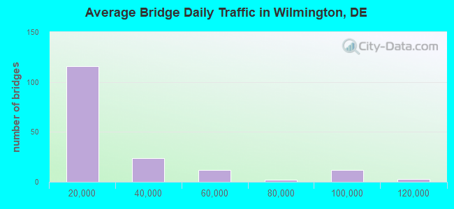
- 3,710,675Total average daily traffic
- 346,538Total average daily truck traffic
- National Bridge Inventory (NBI) Registered Bridges for Wilmington
- No street view available for this location
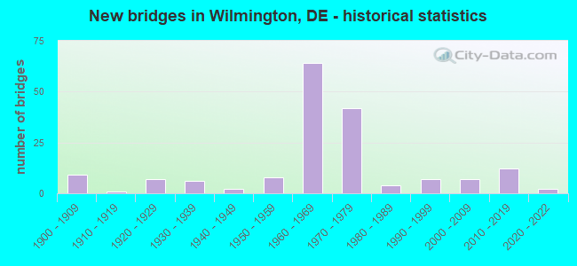
- New bridges - historical statistics
- 91900-1909
- 11910-1919
- 71920-1929
- 61930-1939
- 21940-1949
- 81950-1959
- 641960-1969
- 421970-1979
- 41980-1989
- 71990-1999
- 72000-2009
- 122010-2019
- 22020-2022
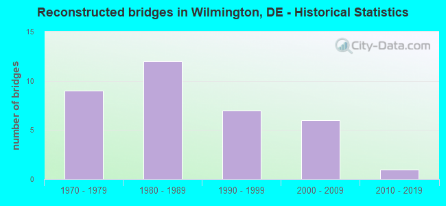
- Reconstructed bridges - Historical Statistics
- 91970-1979
- 121980-1989
- 71990-1999
- 62000-2009
- 12010-2019
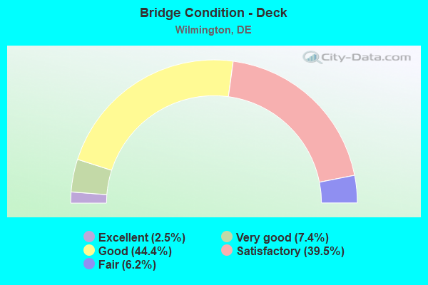
- Bridge Condition - Deck
- 2.5%Excellent
- 7.4%Very good
- 44.4%Good
- 39.5%Satisfactory
- 6.2%Fair
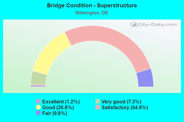
- Bridge Condition - Superstructure
- 1.2%Excellent
- 7.3%Very good
- 26.8%Good
- 54.9%Satisfactory
- 9.8%Fair
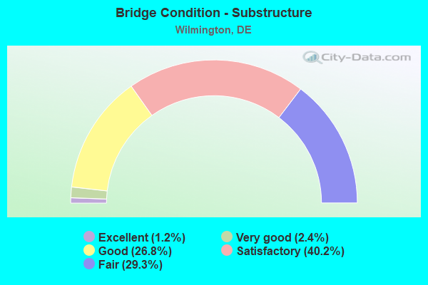
- Bridge Condition - Substructure
- 1.2%Excellent
- 2.4%Very good
- 26.8%Good
- 40.2%Satisfactory
- 29.3%Fair
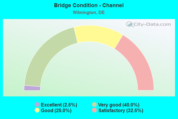
- Bridge Condition - Channel
- 2.5%Excellent
- 40.0%Very good
- 25.0%Good
- 32.5%Satisfactory
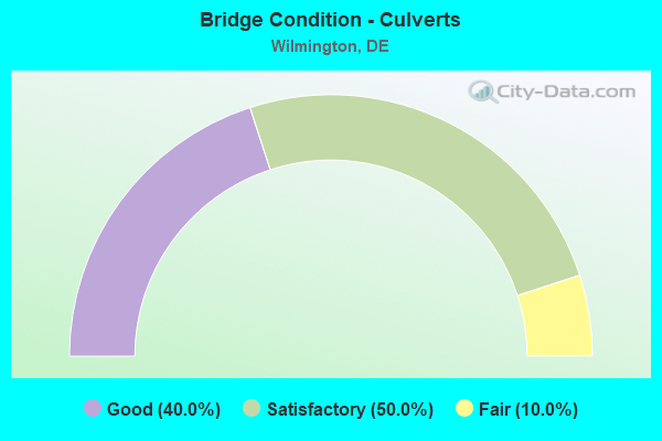
- Bridge Condition - Culverts
- 40.0%Good
- 50.0%Satisfactory
- 10.0%Fair
Find on map >> Show street view
Structure Number: 1755, Location: WILMINGTON (Lat: 39.749189, Lng: -75.556725), Route carried "under" structure: Ramp Interstate 95, Year Built: 1964, Structure Length: 0. m, Average Daily Traffic: 7,791 (year 2019), Truck Traffic: 12%, Features Intersected: I 95 & RAMP 6163, Facility Carried by Structure: 10th STREET
Minimum Vertical Clearance: 5.12m (16.80ft), Kilometerpoint: 0.161, Lanes on structure: 2, Lanes under structure: 1, Material/Design: Steel, Design/Construction: Stringer/Multi-beam, Length of Maximum Span: 18.7m (61.4ft)
Find on map >> Show street view
Structure Number: 1755, Location: WILMINGTON (Lat: 39.749189, Lng: -75.556725), Route carried "under" structure: Interstate 95, Year Built: 1964, Structure Length: 0. m, Average Daily Traffic: 99,798 (year 2019), Truck Traffic: 11%, Features Intersected: I 95 & RAMP 6163, Facility Carried by Structure: 10th STREET
Minimum Vertical Clearance: 5.03m (16.50ft), Kilometerpoint: 7.970, Lanes on structure: 2, Lanes under structure: 4, Material/Design: Steel, Design/Construction: Stringer/Multi-beam, Length of Maximum Span: 18.7m (61.4ft)
Find on map >> Show street view
Structure Number: 1756 6167, Location: WILMINGTON (Lat: 39.750192, Lng: -75.556014), Route carried "under" structure: Ramp Interstate 95, Year Built: 1969, Structure Length: 0. m, Average Daily Traffic: 2,567 (year 2019), Truck Traffic: 8%, Features Intersected: I 95 & RAMP 6169
Minimum Vertical Clearance: 5.66m (18.57ft), Kilometerpoint: 0.000, Lanes on structure: 2, Lanes under structure: 1, Material/Design: Steel, Design/Construction: Stringer/Multi-beam, Length of Maximum Span: 24.1m (79.1ft)
Find on map >> Show street view
Structure Number: 1756 6167, Location: WILMINGTON (Lat: 39.750192, Lng: -75.556014), Route carried "under" structure: Interstate 95, Year Built: 1969, Structure Length: 0. m, Average Daily Traffic: 99,798 (year 2019), Truck Traffic: 9%, Features Intersected: I 95 & RAMP 6169
Minimum Vertical Clearance: 5.07m (16.63ft), Kilometerpoint: 6.598, Lanes on structure: 2, Lanes under structure: 5, Material/Design: Steel, Design/Construction: Stringer/Multi-beam, Length of Maximum Span: 24.1m (79.1ft)
Find on map >> Show street view
Structure Number: 1757 009, Location: WILMINGTON (Lat: 39.751233, Lng: -75.555164), Route carried "under" structure: Ramp Interstate 95, Year Built: 1964, Structure Length: 0. m, Average Daily Traffic: 2,567 (year 2019), Truck Traffic: 8%, Features Intersected: I 95 & RAMP 6167, Facility Carried by Structure: DELAWARE AVE
Minimum Vertical Clearance: 6.16m (20.21ft), Kilometerpoint: 0.225, Lanes on structure: 7, Lanes under structure: 1, Material/Design: Steel, Design/Construction: Stringer/Multi-beam, Length of Maximum Span: 23.3m (76.4ft)
Find on map >> Show street view
Structure Number: 1757 009, Location: WILMINGTON (Lat: 39.751233, Lng: -75.555164), Route carried "under" structure: Interstate 95, Year Built: 1964, Structure Length: 0. m, Average Daily Traffic: 88,511 (year 2019), Truck Traffic: 8%, Features Intersected: I 95 & RAMP 6167, Facility Carried by Structure: DELAWARE AVE
Minimum Vertical Clearance: 6.08m (19.95ft), Kilometerpoint: 8.224, Lanes on structure: 7, Lanes under structure: 4, Material/Design: Steel, Design/Construction: Stringer/Multi-beam, Length of Maximum Span: 23.3m (76.4ft)
Find on map >> Show street view
Structure Number: 1758E6141, Location: WILMINGTON (Lat: 39.741733, Lng: -75.560722), Route carried "under" structure: County highway 505, Year Built: 1976, Structure Length: 0. m, Average Daily Traffic: 3,590 (year 2020), Truck Traffic: 8%, Features Intersected: SECOND ST & ADAMS ST, Facility Carried by Structure: MLK BLD TO I 95 N
Minimum Vertical Clearance: 10.52m (34.51ft), Kilometerpoint: 0.241, Lanes on structure: 1, Lanes under structure: 3, Material/Design: Steel, Design/Construction: Stringer/Multi-beam, Length of Maximum Span: 27.8m (91.2ft)
Find on map >> Show street view
Structure Number: 1758E6141, Location: WILMINGTON (Lat: 39.741733, Lng: -75.560722), Route carried "under" structure: State highway 48, Year Built: 1976, Structure Length: 0. m, Average Daily Traffic: 7,247 (year 2020), Truck Traffic: 8%, Features Intersected: SECOND ST & ADAMS ST, Facility Carried by Structure: MLK BLD TO I 95 N
Minimum Vertical Clearance: 10.73m (35.20ft), Kilometerpoint: 14.774, Lanes on structure: 1, Lanes under structure: 3, Material/Design: Steel, Design/Construction: Stringer/Multi-beam, Length of Maximum Span: 27.8m (91.2ft)
Find on map >> Show street view
Structure Number: 1758F6149, Location: WILMINGTON (Lat: 39.741431, Lng: -75.561147), Route carried "under" structure: State highway 48, Year Built: 1979, Structure Length: 0. m, Average Daily Traffic: 18,230 (year 2019), Truck Traffic: 8%, Features Intersected: MLK BLVD & ADAMS ST, Facility Carried by Structure: RAMP TO I 95 S
Minimum Vertical Clearance: 5.47m (17.95ft), Kilometerpoint: 14.838, Lanes on structure: 1, Lanes under structure: 2, Material/Design: Steel, Design/Construction: Stringer/Multi-beam, Length of Maximum Span: 41.2m (135.2ft)
Find on map >> Show street view
Structure Number: 1758F6149, Location: WILMINGTON (Lat: 39.741431, Lng: -75.561147), Route carried "under" structure: City street 505, Year Built: 1979, Structure Length: 0. m, Average Daily Traffic: 4,516 (year 2019), Truck Traffic: 5%, Features Intersected: MLK BLVD & ADAMS ST, Facility Carried by Structure: RAMP TO I 95 S
Minimum Vertical Clearance: 5.56m (18.24ft), Kilometerpoint: 0.000, Lanes on structure: 1, Lanes under structure: 2, Material/Design: Steel, Design/Construction: Stringer/Multi-beam, Length of Maximum Span: 41.2m (135.2ft)
Find on map >> Show street view
Structure Number: 1758G6149, Location: WILMINGTON (Lat: 39.739028, Lng: -75.562556), Route carried "under" structure: State highway 4, Year Built: 1980, Structure Length: 0. m, Average Daily Traffic: 13,031 (year 2019), Truck Traffic: 8%, Features Intersected: SR 4, MARYLAND AVE., Facility Carried by Structure: MLK BLD TO I 95 S
Minimum Vertical Clearance: 6.78m (22.24ft), Kilometerpoint: 10.251, Lanes on structure: 1, Lanes under structure: 2, Material/Design: Steel, Design/Construction: Stringer/Multi-beam, Length of Maximum Span: 41.9m (137.5ft)
Find on map >> Show street view
Structure Number: 1758H057, Location: WILMINGTON (Lat: 39.740994, Lng: -75.559511), Route carried "under" structure: City street , Year Built: 1976, Structure Length: 0. m, Average Daily Traffic: 100 (year 2019), Truck Traffic: 8%, Features Intersected: MONROE ST & MADISON ST, Facility Carried by Structure: MLK BLVD
Minimum Vertical Clearance: 4.36m (14.30ft), Kilometerpoint: 0.000, Lanes on structure: 2, Lanes under structure: 21, Material/Design: Steel, Design/Construction: Stringer/Multi-beam, Length of Maximum Span: 26.4m (86.6ft)
Find on map >> Show street view
Structure Number: 1758H057, Location: WILMINGTON (Lat: 39.740994, Lng: -75.559511), Route carried "under" structure: City street , Year Built: 1976, Structure Length: 0. m, Average Daily Traffic: 100 (year 2019), Truck Traffic: 8%, Features Intersected: MONROE ST & MADISON ST, Facility Carried by Structure: MLK BLVD
Minimum Vertical Clearance: 7.04m (23.10ft), Kilometerpoint: 0.354, Lanes on structure: 2, Lanes under structure: 2, Material/Design: Steel, Design/Construction: Stringer/Multi-beam, Length of Maximum Span: 26.4m (86.6ft)
Find on map >> Show street view
Structure Number: 1759 059, Location: WILMINGTON (Lat: 39.756433, Lng: -75.552508), Route carried "under" structure: City street , Year Built: 1964, Structure Length: 0. m, Average Daily Traffic: 99 (year 2020), Truck Traffic: 3%, Features Intersected: BRANDYWINE CK, Facility Carried by Structure: I 95 RD 59
Minimum Vertical Clearance: 5.13m (16.83ft), Kilometerpoint: 0.000, Lanes on structure: 6, Lanes under structure: 2, Material/Design: Steel continuous, Design/Construction: Stringer/Multi-beam, Length of Maximum Span: 74.7m (245.1ft)
Find on map >> Show street view
Structure Number: 1759 059, Location: WILMINGTON (Lat: 39.756433, Lng: -75.552508), Route carried "under" structure: City street , Year Built: 1964, Structure Length: 0. m, Average Daily Traffic: 99 (year 2020), Truck Traffic: 3%, Features Intersected: BRANDYWINE CK, Facility Carried by Structure: I 95 RD 59
Minimum Vertical Clearance: 4.30m (14.11ft), Kilometerpoint: 0.000, Lanes on structure: 6, Lanes under structure: 2, Material/Design: Steel continuous, Design/Construction: Stringer/Multi-beam, Length of Maximum Span: 74.7m (245.1ft)
Find on map >> Show street view
Structure Number: 1759 059, Location: WILMINGTON (Lat: 39.756433, Lng: -75.552508), Route carried "under" structure: City street , Year Built: 1964, Structure Length: 0. m, Average Daily Traffic: 99 (year 2020), Truck Traffic: 3%, Features Intersected: BRANDYWINE CK, Facility Carried by Structure: I 95 RD 59
Minimum Vertical Clearance: 4.42m (14.50ft), Kilometerpoint: 0.000, Lanes on structure: 6, Lanes under structure: 2, Material/Design: Steel continuous, Design/Construction: Stringer/Multi-beam, Length of Maximum Span: 74.7m (245.1ft)
Find on map >> Show street view
Structure Number: 1759 059, Location: WILMINGTON (Lat: 39.756433, Lng: -75.552508), Route carried "under" structure: City street , Year Built: 1964, Structure Length: 0. m, Average Daily Traffic: 99 (year 2020), Truck Traffic: 3%, Features Intersected: BRANDYWINE CK, Facility Carried by Structure: I 95 RD 59
Minimum Vertical Clearance: 10.82m (35.50ft), Kilometerpoint: 0.000, Lanes on structure: 6, Lanes under structure: 2, Material/Design: Steel continuous, Design/Construction: Stringer/Multi-beam, Length of Maximum Span: 74.7m (245.1ft)
Find on map >> Show street view
Structure Number: 1760 504, Location: WILMINGTON-SALESIANUM HS (Lat: 39.760936, Lng: -75.551158), Route carried "under" structure: Interstate 95, Year Built: 1966, Structure Length: 0. m, Average Daily Traffic: 102,657 (year 2019), Truck Traffic: 9%, Features Intersected: I 95, Facility Carried by Structure: EIGHTEENTH STREET
Minimum Vertical Clearance: 5.85m (19.19ft), Kilometerpoint: 9.370, Lanes on structure: 2, Lanes under structure: 7, Toll: On toll road, Material/Design: Steel, Design/Construction: Stringer/Multi-beam, Length of Maximum Span: 20.0m (65.6ft)
Find on map >> Show street view
Structure Number: 1762 6175, Location: NORTH OF WILMINGTON (Lat: 39.765639, Lng: -75.542833), Route carried "under" structure: US 202, Year Built: 2013, Structure Length: 0. m, Average Daily Traffic: 37,016 (year 2020), Truck Traffic: 7%, Features Intersected: CONCORD PIKE
Minimum Vertical Clearance: 5.49m (18.01ft), Kilometerpoint: 1.630, Lanes on structure: 2, Lanes under structure: 5, Material/Design: Steel, Design/Construction: Stringer/Multi-beam, Length of Maximum Span: 34.0m (111.5ft)
Find on map >> Show street view
Structure Number: 1763 6175, Location: NORTH OF WILMINGTON (Lat: 39.768528, Lng: -75.540778), Route carried "under" structure: Ramp Interstate 95, Year Built: 2013, Structure Length: 0. m, Average Daily Traffic: 1,210 (year 2020), Truck Traffic: 4%, Features Intersected: I95 SB RAMP TO SB 202
Minimum Vertical Clearance: 5.82m (19.09ft), Kilometerpoint: 0.000, Lanes on structure: 2, Lanes under structure: 1, Material/Design: Steel, Design/Construction: Stringer/Multi-beam, Length of Maximum Span: 20.0m (65.6ft)
Find on map >> Show street view
Structure Number: 1764 6175, Location: NORTH OF WILMINGTON (Lat: 39.767250, Lng: -75.540861), Route carried "under" structure: Interstate 95, Year Built: 2013, Structure Length: 0. m, Average Daily Traffic: 46,639 (year 2020), Truck Traffic: 9%, Features Intersected: I 95
Minimum Vertical Clearance: 5.67m (18.60ft), Kilometerpoint: 10.480, Lanes on structure: 2, Lanes under structure: 4, Material/Design: Steel, Design/Construction: Stringer/Multi-beam, Length of Maximum Span: 33.4m (109.6ft)
Find on map >> Show street view
Structure Number: 1766 059, Location: N.E. OF WILMINGTON (Lat: 39.775272, Lng: -75.527289), Route carried "under" structure: County highway 216, Year Built: 1968, Structure Length: 0. m, Average Daily Traffic: 3,872 (year 2018), Truck Traffic: 9%, Features Intersected: TALLEY ROAD, Facility Carried by Structure: JFK MEM HGY/I95 SB
Minimum Vertical Clearance: 6.85m (22.47ft), Kilometerpoint: 1.240, Lanes on structure: 2, Lanes under structure: 2, Material/Design: Steel continuous, Design/Construction: Stringer/Multi-beam, Length of Maximum Span: 17.5m (57.4ft)
Find on map >> Show street view
Structure Number: 1767 059, Location: N. E. OF WILMINGTON (Lat: 39.774983, Lng: -75.527147), Route carried "under" structure: County highway 216, Year Built: 1968, Structure Length: 0. m, Average Daily Traffic: 3,600 (year 2016), Truck Traffic: 11%, Features Intersected: TALLEY ROAD, Facility Carried by Structure: JFK MEM HGY/I95 NB
Minimum Vertical Clearance: 7.64m (25.07ft), Kilometerpoint: 1.210, Lanes on structure: 2, Lanes under structure: 2, Material/Design: Steel continuous, Design/Construction: Stringer/Multi-beam, Length of Maximum Span: 17.5m (57.4ft)
Find on map >> Show street view
Structure Number: 1771 059, Location: N.E. OF WILMINGTON (Lat: 39.776481, Lng: -75.516997), Route carried "under" structure: County highway 214, Year Built: 1968, Structure Length: 0. m, Average Daily Traffic: 9,896 (year 2019), Truck Traffic: 8%, Features Intersected: SHIPLEY RD, Facility Carried by Structure: I 95 NB
Minimum Vertical Clearance: 6.40m (21.00ft), Kilometerpoint: 1.497, Lanes on structure: 2, Lanes under structure: 2, Material/Design: Steel, Design/Construction: Stringer/Multi-beam, Length of Maximum Span: 20.1m (65.9ft)
Find on map >> Show street view
Structure Number: 1772 059, Location: N.E. OF WILMINGTON (Lat: 39.776811, Lng: -75.516936), Route carried "under" structure: County highway 214, Year Built: 1968, Structure Length: 0. m, Average Daily Traffic: 9,896 (year 2019), Truck Traffic: 8%, Features Intersected: SHIPLEY RD, Facility Carried by Structure: I 95 SB
Minimum Vertical Clearance: 4.73m (15.52ft), Kilometerpoint: 1.500, Lanes on structure: 2, Lanes under structure: 2, Material/Design: Steel, Design/Construction: Stringer/Multi-beam, Length of Maximum Span: 19.1m (62.7ft)
Find on map >> Show street view
Structure Number: 1804 06, Location: SOUTH OF WILMINGTON (Lat: 39.717167, Lng: -75.559933), Route carried "under" structure: Ramp US 6217, Year Built: 1975, Structure Length: 0. m, Average Daily Traffic: 8,689 (year 2019), Truck Traffic: 6%, Features Intersected: RAMP 6217, Facility Carried by Structure: I 495 SB
Minimum Vertical Clearance: 5.37m (17.62ft), Kilometerpoint: 8.690, Lanes on structure: 3, Lanes under structure: 1, Material/Design: Steel, Design/Construction: Stringer/Multi-beam, Length of Maximum Span: 31.1m (102.0ft)
Find on map >> Show street view
Structure Number: 1805 06, Location: SOUTH OF WILMINGTON (Lat: 39.716894, Lng: -75.560033), Route carried "under" structure: Ramp US 6217, Year Built: 1975, Structure Length: 0. m, Average Daily Traffic: 8,689 (year 2019), Truck Traffic: 11%, Features Intersected: RAMP 6217, Facility Carried by Structure: I 495 NB
Minimum Vertical Clearance: 5.03m (16.50ft), Kilometerpoint: 8.660, Lanes on structure: 3, Lanes under structure: 1, Material/Design: Steel, Design/Construction: Stringer/Multi-beam, Length of Maximum Span: 28.7m (94.2ft)
Find on map >> Show street view
Structure Number: 1806 06, Location: S. OF WILMINGTON (Lat: 39.717200, Lng: -75.557325), Route carried "under" structure: US 13, Year Built: 1975, Structure Length: 0. m, Average Daily Traffic: 30,349 (year 2019), Truck Traffic: 9%, Features Intersected: US 13, Facility Carried by Structure: I 495 SB
Minimum Vertical Clearance: 5.04m (16.54ft), Kilometerpoint: 8.690, Lanes on structure: 3, Lanes under structure: 6, Material/Design: Steel continuous, Design/Construction: Stringer/Multi-beam, Length of Maximum Span: 33.1m (108.6ft)
Find on map >> Show street view
Structure Number: 1807 06, Location: SOUTH OF WILMINGTON (Lat: 39.716900, Lng: -75.557592), Route carried "under" structure: US 33, Year Built: 1975, Structure Length: 0. m, Average Daily Traffic: 30,349 (year 2019), Truck Traffic: 9%, Features Intersected: US 13, Facility Carried by Structure: I 495 NB
Minimum Vertical Clearance: 5.36m (17.59ft), Kilometerpoint: 8.660, Lanes on structure: 4, Lanes under structure: 6, Material/Design: Steel continuous, Design/Construction: Stringer/Multi-beam, Length of Maximum Span: 33.1m (108.6ft)
Find on map >> Show street view
Structure Number: 1808 6217, Location: SOUTH OF WILMINGTON (Lat: 39.717814, Lng: -75.556736), Route carried "under" structure: US 13, Year Built: 1975, Structure Length: 0. m, Average Daily Traffic: 32,443 (year 2016), Truck Traffic: 6%, Features Intersected: US 13
Minimum Vertical Clearance: 5.31m (17.42ft), Kilometerpoint: 8.770, Lanes on structure: 1, Lanes under structure: 5, Material/Design: Steel continuous, Design/Construction: Stringer/Multi-beam, Length of Maximum Span: 32.6m (107.0ft)
Find on map >> Show street view
Structure Number: 1809 369, Location: EAST OF WILMINGTON (Lat: 39.717086, Lng: -75.553097), Route carried "under" structure: Interstate 495, Year Built: 1975, Structure Length: 0. m, Average Daily Traffic: 89,567 (year 2019), Truck Traffic: 9%, Features Intersected: I 495, Facility Carried by Structure: ROGERS RD
Minimum Vertical Clearance: 5.26m (17.26ft), Kilometerpoint: 7.741, Lanes on structure: 4, Lanes under structure: 8, Material/Design: Steel continuous, Design/Construction: Stringer/Multi-beam, Length of Maximum Span: 44.4m (145.7ft)
Find on map >> Show street view
Structure Number: 1810 06, Location: SOUTH OF WILMINGTON (Lat: 39.717569, Lng: -75.546333), Route carried "under" structure: State highway 19, Year Built: 1972, Structure Length: 0. m, Average Daily Traffic: 14,604 (year 2019), Truck Traffic: 6%, Features Intersected: SR9, Facility Carried by Structure: I 495 SB
Minimum Vertical Clearance: 6.84m (22.44ft), Kilometerpoint: 6.280, Lanes on structure: 4, Lanes under structure: 4, Material/Design: Steel continuous, Design/Construction: Stringer/Multi-beam, Length of Maximum Span: 39.0m (128.0ft)
Find on map >> Show street view
Structure Number: 1811 06, Location: SOUTH OF WILMINGTON (Lat: 39.717342, Lng: -75.546406), Route carried "under" structure: State highway 9, Year Built: 1972, Structure Length: 0. m, Average Daily Traffic: 14,604 (year 2019), Truck Traffic: 6%, Features Intersected: SR9
Minimum Vertical Clearance: 6.28m (20.60ft), Kilometerpoint: 6.260, Lanes on structure: 3, Lanes under structure: 4, Material/Design: Steel, Design/Construction: Stringer/Multi-beam, Length of Maximum Span: 35.6m (116.8ft)
Find on map >> Show street view
Structure Number: 1812 06, Location: SOUTH OF WILMINGTON (Lat: 39.719878, Lng: -75.540497), Route carried "under" structure: State highway 9A, Year Built: 1972, Structure Length: 0. m, Average Daily Traffic: 5,657 (year 2019), Truck Traffic: 9%, Features Intersected: TERMINAL AVE, RD 359, Facility Carried by Structure: I 495
Minimum Vertical Clearance: 5.03m (16.50ft), Kilometerpoint: 0.430, Lanes on structure: 7, Lanes under structure: 4, Material/Design: Steel, Design/Construction: Stringer/Multi-beam, Length of Maximum Span: 32.3m (106.0ft)
Find on map >> Show street view
Structure Number: 1813 06, Location: WILMINGTON (Lat: 39.723717, Lng: -75.535564), Route carried "under" structure: Alternate State highway 9A, Year Built: 1974, Structure Length: 0. m, Average Daily Traffic: 8,527 (year 2019), Truck Traffic: 7%, Features Intersected: CHRISTINA RIVER, N/S RR, Facility Carried by Structure: I 495
Minimum Vertical Clearance: 13.78m (45.21ft), Kilometerpoint: 2.334, Lanes on structure: 6, Lanes under structure: 2, Material/Design: Steel continuous, Design/Construction: Girder and Floorbeam System, Length of Maximum Span: 99.1m (325.1ft)
Find on map >> Show street view
Structure Number: 1815 009, Location: WILMINGTON (Lat: 39.735664, Lng: -75.521553), Route carried "under" structure: Interstate 495, Year Built: 1977, Structure Length: 0. m, Average Daily Traffic: 84,390 (year 2018), Truck Traffic: 15%, Features Intersected: I-495 RD 60, Facility Carried by Structure: TWELTH ST
Minimum Vertical Clearance: 5.25m (17.22ft), Kilometerpoint: 7.162, Lanes on structure: 4, Lanes under structure: 6, Material/Design: Steel continuous, Design/Construction: Stringer/Multi-beam, Length of Maximum Span: 28.0m (91.9ft)
Find on map >> Show street view
Structure Number: 1821N06, Location: EDGEMOOR (Lat: 39.751567, Lng: -75.502594), Route carried "under" structure: State highway 3, Year Built: 1975, Structure Length: 0. m, Average Daily Traffic: 9,566 (year 2019), Truck Traffic: 8%, Features Intersected: EDGEMOOR RD, Facility Carried by Structure: I 495 NB
Minimum Vertical Clearance: 5.00m (16.40ft), Kilometerpoint: 0.145, Lanes on structure: 4, Lanes under structure: 4, Material/Design: Steel continuous, Design/Construction: Stringer/Multi-beam, Length of Maximum Span: 23.3m (76.4ft)